2013 Vol. 38, No. 3
Display Method:
 PDF 521KB
2013, 38(3): 441-453.
doi: 10.3799/dqkx.2013.044
Abstract:
Results of chemical analysis on rock samples collected from the north Pingdingshan Section, Chaohu, Anhui Province, Southeastern China, suggest that main elements of SiO2, Al2O3, Fe2O3, FeO, MgO, Na2O, K2O, TiO2, P2O5 and trace elements of Ba, V, Be, Nb, Zn, Cu, Ni, Co, Pb are rich in the Griesbachian, the Dienerian, as well as in the Smithian Subseries in the Lower Triassic. Eight distinct positive anomalies have been identified in the Lower Triassic on the basis of results of main and trace elements mentioned above. In ascending order, strength, size of anomalies and content of these elements in the Lower Triassic decrease gradually. In contrast to these elements, Sr and CaO are relatively concentrated in the Spathian subseries in the uppermost part of the Lower Triassic. Furthermore, trace element of Sr and main element of CaO enrich gradually up the north Pindingshan Section. Content of the former elements has negative correlation with δ13C values of carbonate, while the content of the later elements is positively related with δ13C values of carbonate. Commonly, δ13C value is used as an indicator of marine primary production and also used as an indicator to define restoration of marine ecological environment. Negative correlation between element contents and δ13C values indicates that the deteriorating marine environment is the tremendous disaster to the Early Triassic marine fauna in the Lower Yangtze region, while the positive correlation between element contents and δ13C values present that the feasible marine environment to the Early Triassic fauna. Eight marine geo-events have been identified in the Early Triassic based on the pronounced anomalies of trace elements and main elements. Strength of these events became weaker and weaker from the early Early Triassic to the late Early Triassic. A plenty of trace elements from the terrestrial volcano eruptions fluxed into the sea during the Late Permian and the Early Triassic, resulting in high content of argillaceous minerals and high grade of trace elements which led to paleocean environment deteriorating. Marine environment recovered as soon as the superfluous trace elements and argillaceous minerals deposited on the sea floor after volcano activities ceased.
Results of chemical analysis on rock samples collected from the north Pingdingshan Section, Chaohu, Anhui Province, Southeastern China, suggest that main elements of SiO2, Al2O3, Fe2O3, FeO, MgO, Na2O, K2O, TiO2, P2O5 and trace elements of Ba, V, Be, Nb, Zn, Cu, Ni, Co, Pb are rich in the Griesbachian, the Dienerian, as well as in the Smithian Subseries in the Lower Triassic. Eight distinct positive anomalies have been identified in the Lower Triassic on the basis of results of main and trace elements mentioned above. In ascending order, strength, size of anomalies and content of these elements in the Lower Triassic decrease gradually. In contrast to these elements, Sr and CaO are relatively concentrated in the Spathian subseries in the uppermost part of the Lower Triassic. Furthermore, trace element of Sr and main element of CaO enrich gradually up the north Pindingshan Section. Content of the former elements has negative correlation with δ13C values of carbonate, while the content of the later elements is positively related with δ13C values of carbonate. Commonly, δ13C value is used as an indicator of marine primary production and also used as an indicator to define restoration of marine ecological environment. Negative correlation between element contents and δ13C values indicates that the deteriorating marine environment is the tremendous disaster to the Early Triassic marine fauna in the Lower Yangtze region, while the positive correlation between element contents and δ13C values present that the feasible marine environment to the Early Triassic fauna. Eight marine geo-events have been identified in the Early Triassic based on the pronounced anomalies of trace elements and main elements. Strength of these events became weaker and weaker from the early Early Triassic to the late Early Triassic. A plenty of trace elements from the terrestrial volcano eruptions fluxed into the sea during the Late Permian and the Early Triassic, resulting in high content of argillaceous minerals and high grade of trace elements which led to paleocean environment deteriorating. Marine environment recovered as soon as the superfluous trace elements and argillaceous minerals deposited on the sea floor after volcano activities ceased.


2013, 38(3): 454-460.
doi: 10.3799/dqkx.2013.045
Abstract:
Iron geochemistry has rapidly attracted great interest for global change research over the last two decades due to its significant role in the evolution of earth environment and in marine primary productivity. The speciation of particulate iron is critical for better understanding of iron transformation, transitivity and bioavailability. This paper systematically reviews the analytical development of low-temperature particulate Fe speciation, including the degree of pyritization (DOP), Tessier's sequential extraction method, and specific iron extraction procedure. The application of three-step iron extraction is introduced, and some suggestions are given for the future iron speciation analysis based on the latest development of iron geochemical study.
Iron geochemistry has rapidly attracted great interest for global change research over the last two decades due to its significant role in the evolution of earth environment and in marine primary productivity. The speciation of particulate iron is critical for better understanding of iron transformation, transitivity and bioavailability. This paper systematically reviews the analytical development of low-temperature particulate Fe speciation, including the degree of pyritization (DOP), Tessier's sequential extraction method, and specific iron extraction procedure. The application of three-step iron extraction is introduced, and some suggestions are given for the future iron speciation analysis based on the latest development of iron geochemical study.

2013, 38(3): 461-470.
doi: 10.3799/dqkx.2013.046
Abstract:
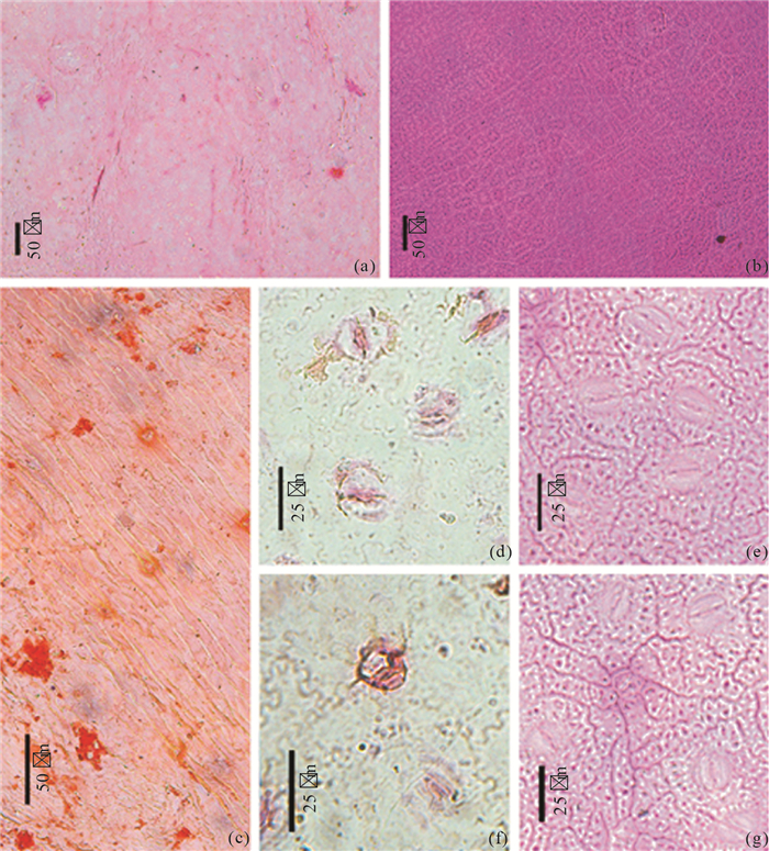
Leaf fossils are collected for this study from the Shengxian Formation in Tiantai, Zhejiang Province. There are abundant compressed angiosperm fossils and a few gymnosperm fossils in the Shengxian Formation. Based on steady macromorphology of leaf including the base, the apex, the vein and so on, one species of Lauraceae plant fossils is studied in detail by analyzing the leaf architecture and cuticle characteristics in this paper. The fossil leaves and living Cinnamomum bejolghota (Buch-Ham.) Sweet are found sharing resemblance on the leaf shape, leaf vein, vein cell, stomata type and the features of trichomes. So the fossil leaves are identified as Cinnamomum bejolghota. Based on cuticle characteristics of fossil leaves and the distribution area and survival environment of living Cinnamomum bejolghota, we come to the following conclusions on the paleoclimate and paleoenviroment in eastern Zhejiang, that it was hotter and moister than present, and the distribution area of Cinnamomum bejolghota moved southward from Miocene.
Leaf fossils are collected for this study from the Shengxian Formation in Tiantai, Zhejiang Province. There are abundant compressed angiosperm fossils and a few gymnosperm fossils in the Shengxian Formation. Based on steady macromorphology of leaf including the base, the apex, the vein and so on, one species of Lauraceae plant fossils is studied in detail by analyzing the leaf architecture and cuticle characteristics in this paper. The fossil leaves and living Cinnamomum bejolghota (Buch-Ham.) Sweet are found sharing resemblance on the leaf shape, leaf vein, vein cell, stomata type and the features of trichomes. So the fossil leaves are identified as Cinnamomum bejolghota. Based on cuticle characteristics of fossil leaves and the distribution area and survival environment of living Cinnamomum bejolghota, we come to the following conclusions on the paleoclimate and paleoenviroment in eastern Zhejiang, that it was hotter and moister than present, and the distribution area of Cinnamomum bejolghota moved southward from Miocene.


2013, 38(3): 471-481.
doi: 10.3799/dqkx.2013.047
Abstract:
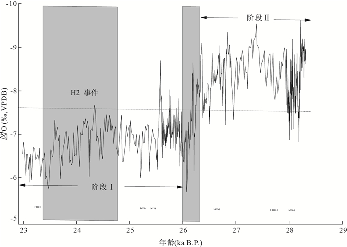
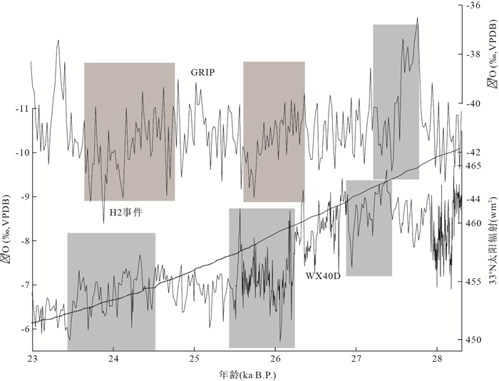
Wanxiang Cave is sensitive to climate change due to its special geographic location, located at the transition of Tibet plateau and Loess plateau. A 10-year resolution oxygen isotope record of stalagmite from the Wanxiang Cave, based on 6 precise 230Th dates and 616 oxygen isotopic measurements provides a detailed history of the Asian Monsoon from 28.3 to 23.0 ka B.P.. A high-resolution oxygen isotopic record reveals decadal-centural oscillations in air temperature in the East Asian monsoon climate area during the early time of marine isotope stadial 2 (MIS2). The most conspicuous feature in the oxygen isotopic record in the period is the particularly cold event synchronized with the penultimate Heinrich event (H2) in the northern Atlantic deep-sea records. This particular cold event, beginning at 24.6 ka B.P., δ18O record demonstrates that the event lasted 1 200 years with gradually cooling, which is different from δ18O record from Hulu Cave and Tian'e Cave—a gradually cooling tendency after the remarkable cooling down. However, the δ18O record from Wanxiang Cave matches well with 33°N insolation and δ18O record from Jintanwan, Hunan Province; The cooling event recorded in Wanxiang Cave is also consistent with δ18O record in GRIP. We maintain that this unique pattern of event recorded in the stalagmite δ18O might be controlled by various factors including solar radiation, expansion of ice raft debrise in the northern Atlantic and sea surface temperature.The particular location of the Wanxiang Cave makes the stalagmite δ18O easily affected by Asian winter monsoon and westly circulation correlated with Polar climate.
Wanxiang Cave is sensitive to climate change due to its special geographic location, located at the transition of Tibet plateau and Loess plateau. A 10-year resolution oxygen isotope record of stalagmite from the Wanxiang Cave, based on 6 precise 230Th dates and 616 oxygen isotopic measurements provides a detailed history of the Asian Monsoon from 28.3 to 23.0 ka B.P.. A high-resolution oxygen isotopic record reveals decadal-centural oscillations in air temperature in the East Asian monsoon climate area during the early time of marine isotope stadial 2 (MIS2). The most conspicuous feature in the oxygen isotopic record in the period is the particularly cold event synchronized with the penultimate Heinrich event (H2) in the northern Atlantic deep-sea records. This particular cold event, beginning at 24.6 ka B.P., δ18O record demonstrates that the event lasted 1 200 years with gradually cooling, which is different from δ18O record from Hulu Cave and Tian'e Cave—a gradually cooling tendency after the remarkable cooling down. However, the δ18O record from Wanxiang Cave matches well with 33°N insolation and δ18O record from Jintanwan, Hunan Province; The cooling event recorded in Wanxiang Cave is also consistent with δ18O record in GRIP. We maintain that this unique pattern of event recorded in the stalagmite δ18O might be controlled by various factors including solar radiation, expansion of ice raft debrise in the northern Atlantic and sea surface temperature.The particular location of the Wanxiang Cave makes the stalagmite δ18O easily affected by Asian winter monsoon and westly circulation correlated with Polar climate.


2013, 38(3): 482-488.
doi: 10.3799/dqkx.2013.048
Abstract:
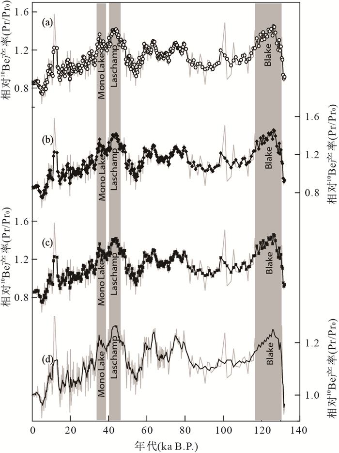
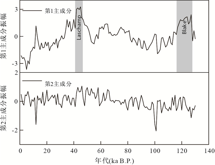
The 10Be records in Chinese loess can't be used for tracing the paleogeomagnetic change because of the significant climate effect, so we need to do research on signal separation. The difficulties are summarized in the reconstruction of the paleogeomagnetic intensity by using the 10Be records in Chinese loess in this paper. Here we present the advantages and shortcomings in our methods used to separate climate effects and geomagnetic modulation effects from 10Be concentration. Based on these methods, principal component analysis (PCA) is used to extract the common signal of 10Be from Luochuan and Xifeng loess sections to further clear up the effect of the climate change, noise and other random signals, which we interpret as variations of the global 10Be production rate of the past 130 ka. The PCA method presented here may be facilitated to solve the difficulties in geological or other signal separation.
The 10Be records in Chinese loess can't be used for tracing the paleogeomagnetic change because of the significant climate effect, so we need to do research on signal separation. The difficulties are summarized in the reconstruction of the paleogeomagnetic intensity by using the 10Be records in Chinese loess in this paper. Here we present the advantages and shortcomings in our methods used to separate climate effects and geomagnetic modulation effects from 10Be concentration. Based on these methods, principal component analysis (PCA) is used to extract the common signal of 10Be from Luochuan and Xifeng loess sections to further clear up the effect of the climate change, noise and other random signals, which we interpret as variations of the global 10Be production rate of the past 130 ka. The PCA method presented here may be facilitated to solve the difficulties in geological or other signal separation.


2013, 38(3): 489-500.
doi: 10.3799/dqkx.2013.049
Abstract:
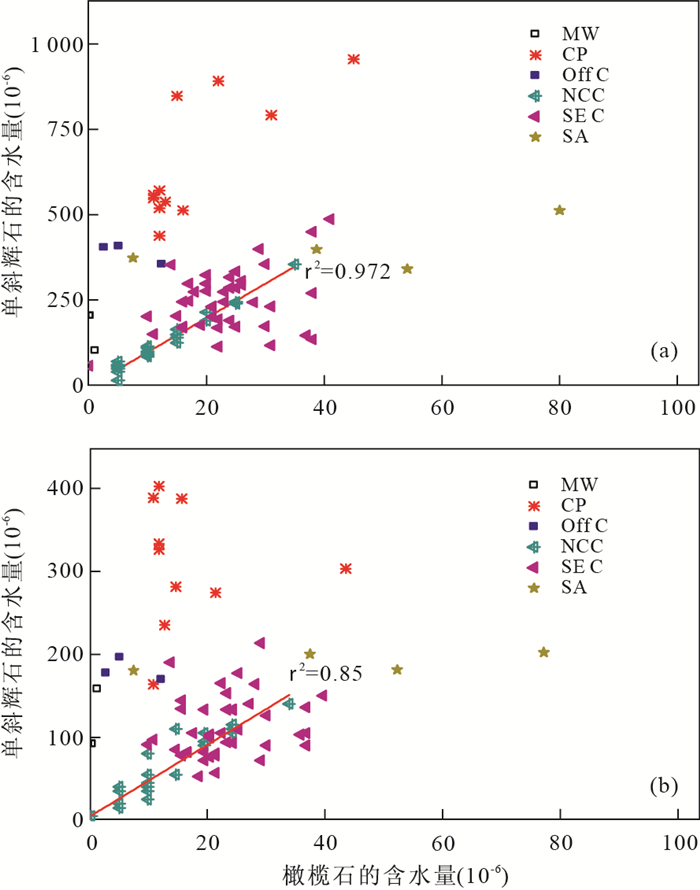
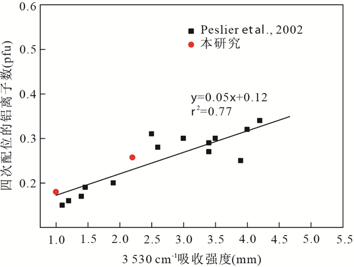
Hydroxyl in minerals from upper mantle peridotite plays an important role in the evolution of the earth's interior. In order to understand the correlation between geological setting and hydroxyl incorporation in lherzolite,OH contents of 13 garnet/spinel lherzolite samples from different geological settings (i.e. stable craton,reactivated craton,mantle plume,subduction zone and UHP terrane) were investigated by fourier transform infrared (FTIR) spectroscopy analysis. The results demonstrate: (1) water contents in olivine and bulk rock follow the trend of UHP terrain >mantle plumb>stable craton >subduction zone >activated craton; (2) garnet lherzolite contains more water than that of spinel lherzolite for samples from the same geological setting,indicating that the upper mantle should be stratified with depth in terms of water distribution; (3) the presence of [Si] deficiency-caused IR peaks at 3 611-3 613 cm-1 together with the absence of [Fe3+] caused peaks at 3 325 cm-1 and 3 355 cm-1 indicates the upper mantle is more reduced with increasing pressure.
Hydroxyl in minerals from upper mantle peridotite plays an important role in the evolution of the earth's interior. In order to understand the correlation between geological setting and hydroxyl incorporation in lherzolite,OH contents of 13 garnet/spinel lherzolite samples from different geological settings (i.e. stable craton,reactivated craton,mantle plume,subduction zone and UHP terrane) were investigated by fourier transform infrared (FTIR) spectroscopy analysis. The results demonstrate: (1) water contents in olivine and bulk rock follow the trend of UHP terrain >mantle plumb>stable craton >subduction zone >activated craton; (2) garnet lherzolite contains more water than that of spinel lherzolite for samples from the same geological setting,indicating that the upper mantle should be stratified with depth in terms of water distribution; (3) the presence of [Si] deficiency-caused IR peaks at 3 611-3 613 cm-1 together with the absence of [Fe3+] caused peaks at 3 325 cm-1 and 3 355 cm-1 indicates the upper mantle is more reduced with increasing pressure.


2013, 38(3): 501-507.
doi: 10.3799/dqkx.2013.050
Abstract:
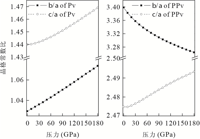
The elastic property and seismic velocity of Post-Perovsikt (PPv) MgSiO3 have been studied using first-principles calculations based on density of functional theory (DFT).Firstly, the stability of PPv-MgSiO3 under high pressure is validated through total energy calculations and the criterion of mechanical stability.The obtained lattice constants are in accordance well with the previous calculated and experimental results.The calculations indicate that the bulk modulus, shear modulus, density and seismic velocity of PPv-MgSiO3 are larger than those of Pv-MgSiO3, which are in agreement with seismic observations.Under hydrostatic pressure, the anisotropy of compressed wave has little change, while that of shear wave is enhanced.For the uniaxial pressure, both compressed and shear anisotropies are increased with strain along the a or c axis, while are decreased with strain along the b axis with respect to that of hydrostatic pressure.This study is useful for explaining the seismic velocity discontinuity and lateral heterogeneity in the D" layer.
The elastic property and seismic velocity of Post-Perovsikt (PPv) MgSiO3 have been studied using first-principles calculations based on density of functional theory (DFT).Firstly, the stability of PPv-MgSiO3 under high pressure is validated through total energy calculations and the criterion of mechanical stability.The obtained lattice constants are in accordance well with the previous calculated and experimental results.The calculations indicate that the bulk modulus, shear modulus, density and seismic velocity of PPv-MgSiO3 are larger than those of Pv-MgSiO3, which are in agreement with seismic observations.Under hydrostatic pressure, the anisotropy of compressed wave has little change, while that of shear wave is enhanced.For the uniaxial pressure, both compressed and shear anisotropies are increased with strain along the a or c axis, while are decreased with strain along the b axis with respect to that of hydrostatic pressure.This study is useful for explaining the seismic velocity discontinuity and lateral heterogeneity in the D" layer.


2013, 38(3): 508-518.
doi: 10.3799/dqkx.2013.051
Abstract:
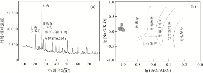
The Qiangtang basin is located between the Jinshajiang suture (JSS) and Bangong-Nujiang suture. It is an important petroliferous basin in the northern Tibet Plateau, China. It is formed by the stacking of many basins of different stages, properties and generations. There have always been a lot of debate about the Late Triassic property of Qiangtang basin, so the Late Triassic Zangxiahe Formation is selected as the research subject in this paper. The Zangxiahe Formation, which is deposited on the northern margin of the Qiangtang basin, is a very thick flysch (> 3 000 m) with sandstone and shale sediments. It is an very important indicator for the Late Triassic property of Qiangtang basin. The X-ray diffraction (XRD), major compositions, rare earth elements and trace elements of the whole rocks and the fission tracks of clastic zircon of the sandstones from Zangxiahe Formation in Qiangtang basin are studied in this paper, which reveals that the tectonic settings of source rock area belong to active continental margin and continental island arc. Combined with the results of previous studies, it is concluded that the main source area is JSS and the major source rocks are the felsic rocks. The felsic rocks are likely the S-COLG which intruded into the JSS in Middle Triassic. The deposition time of the Late Triassic Zangxiahe Formation is the same as the formation time of JSS. So the Late Triassic Qiangtang basin is a peripheral foreland basin.
The Qiangtang basin is located between the Jinshajiang suture (JSS) and Bangong-Nujiang suture. It is an important petroliferous basin in the northern Tibet Plateau, China. It is formed by the stacking of many basins of different stages, properties and generations. There have always been a lot of debate about the Late Triassic property of Qiangtang basin, so the Late Triassic Zangxiahe Formation is selected as the research subject in this paper. The Zangxiahe Formation, which is deposited on the northern margin of the Qiangtang basin, is a very thick flysch (> 3 000 m) with sandstone and shale sediments. It is an very important indicator for the Late Triassic property of Qiangtang basin. The X-ray diffraction (XRD), major compositions, rare earth elements and trace elements of the whole rocks and the fission tracks of clastic zircon of the sandstones from Zangxiahe Formation in Qiangtang basin are studied in this paper, which reveals that the tectonic settings of source rock area belong to active continental margin and continental island arc. Combined with the results of previous studies, it is concluded that the main source area is JSS and the major source rocks are the felsic rocks. The felsic rocks are likely the S-COLG which intruded into the JSS in Middle Triassic. The deposition time of the Late Triassic Zangxiahe Formation is the same as the formation time of JSS. So the Late Triassic Qiangtang basin is a peripheral foreland basin.


2013, 38(3): 519-528.
doi: 10.3799/dqkx.2013.052
Abstract:
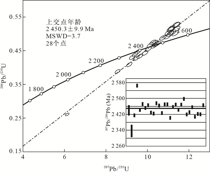
Songduo rock group includes Chashagang rock formation, Mabuku rock formation and Leilongku rock formation, which takes on fault blocks locating in the eastern Lhasa block, and its age has long been argued. The high accurate LA-ICP-MS zircon U-Pb isotope dating of meta-basic volcanic rock from Chashagang rock formation in Gongbujiangda County, Tibet, yielded a U-Pb upper-intercept age of 2 450.3±9.9 Ma. It is suggested a rock-forming age and the oldest isotopic age of basement of Lhasa block, belonging to the Early Paleoproterozoic. According to field investigation and the new data of geochronology, combining with new results from regional geological survey, we propose that "the original Songduo rock group" should be disintergrated, and re-establish a Gongbujiangda rock group. The Songduo rock Group only remain Mabuku rock formation (AnOm) and Leilongku rock Formation (AnOl). It is great significance to redefinite the Precambrian basement framework, compare in region, subdivide tectonic units, and find minerals related with the Precambrian.
Songduo rock group includes Chashagang rock formation, Mabuku rock formation and Leilongku rock formation, which takes on fault blocks locating in the eastern Lhasa block, and its age has long been argued. The high accurate LA-ICP-MS zircon U-Pb isotope dating of meta-basic volcanic rock from Chashagang rock formation in Gongbujiangda County, Tibet, yielded a U-Pb upper-intercept age of 2 450.3±9.9 Ma. It is suggested a rock-forming age and the oldest isotopic age of basement of Lhasa block, belonging to the Early Paleoproterozoic. According to field investigation and the new data of geochronology, combining with new results from regional geological survey, we propose that "the original Songduo rock group" should be disintergrated, and re-establish a Gongbujiangda rock group. The Songduo rock Group only remain Mabuku rock formation (AnOm) and Leilongku rock Formation (AnOl). It is great significance to redefinite the Precambrian basement framework, compare in region, subdivide tectonic units, and find minerals related with the Precambrian.


2013, 38(3): 529-540.
doi: 10.3799/dqkx.2013.053
Abstract:
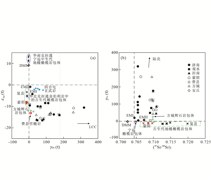
A Re-Os isotopic study of Mesozoic igneous basic to intermediate basic rocks from the western-, eastern- and Yishu fault belt tectonic units in Shandong province, North China Craton (NCC), is carried out. The samples consists of 13 intrusive rocks from the Jinan, Yinan plutons and Guanshui dykes, and 13 volcanic rocks from the Anqiu, Mengyin, Feixian and Fangcheng volcanic successions. Most samples have relatively low Re (0.076×10⁻⁹-0.711×10⁻⁹) and Os (0.006×10⁻⁹-1.030×10⁻⁹) contents and high radiogenic 187Os/188Os ratios, with corresponding initial 187Os/188Os ratio of 0.131 6-0.529 1 and γOs(t) of 4.30-319.00, except for rock MAQ0609 of the Anqiu trachyandesite with initial 187Os/188Os ratio of 1.463 and γOs(t) of 1 060.000. The igneous rocks show a wide range of 0.125 to 2.090 Ga in Os isotope modal age (TMA). On the γOs(t) vs. εNd(t) and (87Sr/86Sr)i vs. γOs(t) diagrams, these rocks are positioned between the lithospheric mantle and crust fields, indicative of a crust-mantle interaction-related origin. All but one Guanshui gabbro (MGS0610) and Feixian basalts of the samples display no clear positive correlation between γOs(t) and (La/Ta)N or (Th/Nb)N, which suggests that the role of crustal assimilation or contamination during the magma ascending was insignificant. Compared with the Paleozoic mantle xenoliths, these mantle-derived rocks have evidently younger Os modal ages, higher Re/Os and 187Os/188Os ratios. These crustal signs are likely to have been resulted from interactions of partial melts derived from delaminated lower crust rocks with ambient mantle under an upper mantle depth. Besides, on the Re/Yb vs. Yb diagram, samples of the Mengyin andesites and Yinan diorites are plotted between the Mesozoic pyroxene xenoliths and crust components, which may be best explained by mantle source rocks metasomatized by partial melts of delaminated eclogitic lower crust. Furthermore, a Mengyin andesite MMY-12 (SiO2=56.4%) has a modal age as old as 2.090 Ga, and high Mg# (64.6) and Os content (0.089×10⁻⁹), which provides an additional evidence for lithospheric thinning-related interaction between the delaminated lower crust and the convecting upper mantle.
A Re-Os isotopic study of Mesozoic igneous basic to intermediate basic rocks from the western-, eastern- and Yishu fault belt tectonic units in Shandong province, North China Craton (NCC), is carried out. The samples consists of 13 intrusive rocks from the Jinan, Yinan plutons and Guanshui dykes, and 13 volcanic rocks from the Anqiu, Mengyin, Feixian and Fangcheng volcanic successions. Most samples have relatively low Re (0.076×10⁻⁹-0.711×10⁻⁹) and Os (0.006×10⁻⁹-1.030×10⁻⁹) contents and high radiogenic 187Os/188Os ratios, with corresponding initial 187Os/188Os ratio of 0.131 6-0.529 1 and γOs(t) of 4.30-319.00, except for rock MAQ0609 of the Anqiu trachyandesite with initial 187Os/188Os ratio of 1.463 and γOs(t) of 1 060.000. The igneous rocks show a wide range of 0.125 to 2.090 Ga in Os isotope modal age (TMA). On the γOs(t) vs. εNd(t) and (87Sr/86Sr)i vs. γOs(t) diagrams, these rocks are positioned between the lithospheric mantle and crust fields, indicative of a crust-mantle interaction-related origin. All but one Guanshui gabbro (MGS0610) and Feixian basalts of the samples display no clear positive correlation between γOs(t) and (La/Ta)N or (Th/Nb)N, which suggests that the role of crustal assimilation or contamination during the magma ascending was insignificant. Compared with the Paleozoic mantle xenoliths, these mantle-derived rocks have evidently younger Os modal ages, higher Re/Os and 187Os/188Os ratios. These crustal signs are likely to have been resulted from interactions of partial melts derived from delaminated lower crust rocks with ambient mantle under an upper mantle depth. Besides, on the Re/Yb vs. Yb diagram, samples of the Mengyin andesites and Yinan diorites are plotted between the Mesozoic pyroxene xenoliths and crust components, which may be best explained by mantle source rocks metasomatized by partial melts of delaminated eclogitic lower crust. Furthermore, a Mengyin andesite MMY-12 (SiO2=56.4%) has a modal age as old as 2.090 Ga, and high Mg# (64.6) and Os content (0.089×10⁻⁹), which provides an additional evidence for lithospheric thinning-related interaction between the delaminated lower crust and the convecting upper mantle.


2013, 38(3): 541-552.
doi: 10.3799/dqkx.2013.054
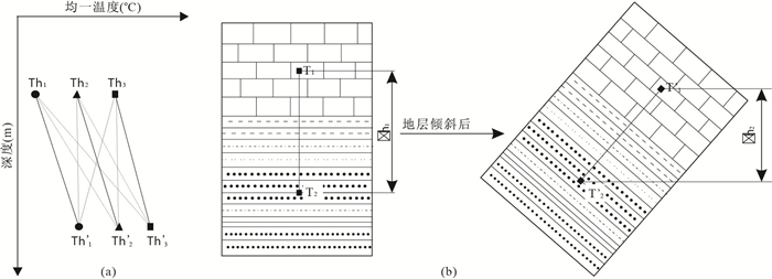
Abstract:
Although many scholars have done a lot of research on the uplift mechanism of Tibet plateau, intercontinental subduction, mid-low crust flowing and magmatic activities, the thermal regime and paleogeothermal gradient evolution in the Mesozoic-Cenozoic sedimentary basins have rarely been studied. But the thermal regime and evolution of paleogeothermal gradient have great significance for the hydrocarbon generation processes and hydrocarbon preservation of the Mesozoic marine source rocks. On the basis of achievements of the previous research on the temperature field of Tibet plateau and evolution of basin types, using the fluid inclusion homogenous temperature, the paleogeothermal gradient evolution curves of the Mesozoic marine basins in Tibet plateau are formed in this paper. And it suggests that the Mesozoic marine basins in the low paleogeothermal gradient (< 3.0 ℃/100 m) when they were in the evolution process from continental margin rift basins to back-arc basins and then to foreland basins during Mesozoic to Eocene, which were beneficial for the generation of mature oil. After that these basins evolved into residual basins and the paleogeothermal gradient rising sharply (~6.5 ℃/100 m) because of continuous and periodic uplifts of the Tibet plateau during Neogene to Quaternary, which resulted in the possibility of that the oil reservoir was cracked into natural gas and secondary hydrocarbon generation of the Mesozoic marine source rocks. Therefore, the paleogeothermal gradient evolution determines the exploration potential for oil in the cooling basin and the exploration potential for gas in the heating basin.
Although many scholars have done a lot of research on the uplift mechanism of Tibet plateau, intercontinental subduction, mid-low crust flowing and magmatic activities, the thermal regime and paleogeothermal gradient evolution in the Mesozoic-Cenozoic sedimentary basins have rarely been studied. But the thermal regime and evolution of paleogeothermal gradient have great significance for the hydrocarbon generation processes and hydrocarbon preservation of the Mesozoic marine source rocks. On the basis of achievements of the previous research on the temperature field of Tibet plateau and evolution of basin types, using the fluid inclusion homogenous temperature, the paleogeothermal gradient evolution curves of the Mesozoic marine basins in Tibet plateau are formed in this paper. And it suggests that the Mesozoic marine basins in the low paleogeothermal gradient (< 3.0 ℃/100 m) when they were in the evolution process from continental margin rift basins to back-arc basins and then to foreland basins during Mesozoic to Eocene, which were beneficial for the generation of mature oil. After that these basins evolved into residual basins and the paleogeothermal gradient rising sharply (~6.5 ℃/100 m) because of continuous and periodic uplifts of the Tibet plateau during Neogene to Quaternary, which resulted in the possibility of that the oil reservoir was cracked into natural gas and secondary hydrocarbon generation of the Mesozoic marine source rocks. Therefore, the paleogeothermal gradient evolution determines the exploration potential for oil in the cooling basin and the exploration potential for gas in the heating basin.


2013, 38(3): 553-560.
doi: 10.3799/dqkx.2013.055
Abstract:
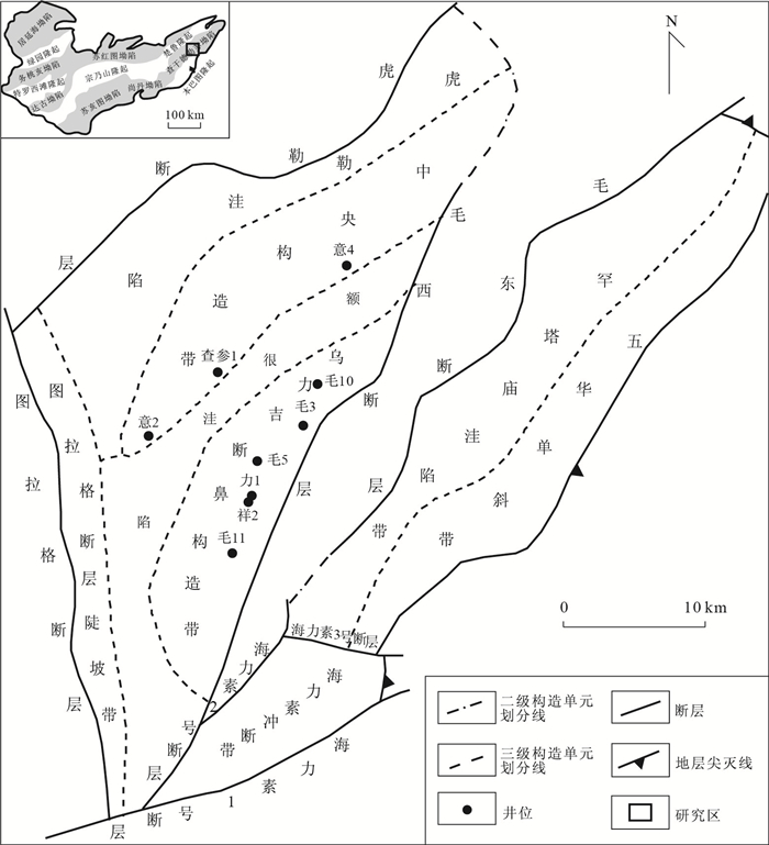
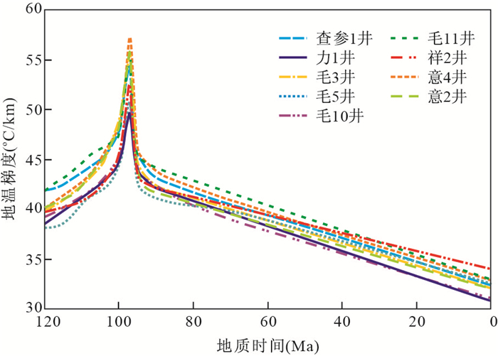
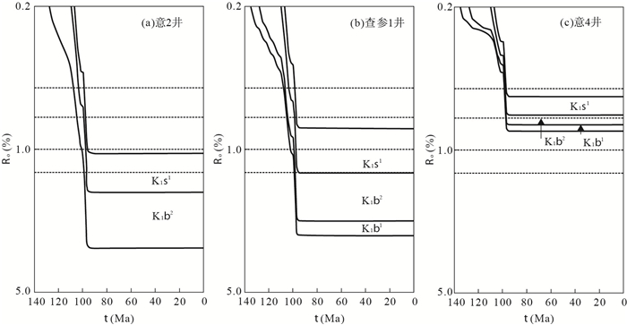
The Chagan sag has the greatest potential for oil and gas exploration among other sags in the Yin'gen-Ejinaqi basin. To reveal the Mesozoic and Cenozoic thermal history and source rock thermal evolution history in the Chagan sag, the thermal history was modeled on basis of vitrinite reflectance data of 9 wells. The modeled results show the thermal gradients increased gradually from the Early Cretaceous Bayin'gebi Formation to the end of the Yin'gen Formation, and the thermal gradients reached maximum values(50-58 ℃/km) at the end of the Yingen Formation.Then the thermal gradients decreased gradually from the Late Cretaceous Wulansuhai Formation to the present day, and the thermal gradients is only 31-34 ℃/km in the present day. Meanwhile, based on the above thermal gradient data, with combination of the depositional and tectonic development history and geochemical parameters of source rocks, maturation histories of 3 sets of source rocks of 9 wells were modeled. The modeled results show the maturation histories were controlled by the palaeogeothermal, and the maturation of 3 sets of source rocks reached maximum values in the late period of the Early Cretaceous.
The Chagan sag has the greatest potential for oil and gas exploration among other sags in the Yin'gen-Ejinaqi basin. To reveal the Mesozoic and Cenozoic thermal history and source rock thermal evolution history in the Chagan sag, the thermal history was modeled on basis of vitrinite reflectance data of 9 wells. The modeled results show the thermal gradients increased gradually from the Early Cretaceous Bayin'gebi Formation to the end of the Yin'gen Formation, and the thermal gradients reached maximum values(50-58 ℃/km) at the end of the Yingen Formation.Then the thermal gradients decreased gradually from the Late Cretaceous Wulansuhai Formation to the present day, and the thermal gradients is only 31-34 ℃/km in the present day. Meanwhile, based on the above thermal gradient data, with combination of the depositional and tectonic development history and geochemical parameters of source rocks, maturation histories of 3 sets of source rocks of 9 wells were modeled. The modeled results show the maturation histories were controlled by the palaeogeothermal, and the maturation of 3 sets of source rocks reached maximum values in the late period of the Early Cretaceous.


2013, 38(3): 561-572.
doi: 10.3799/dqkx.2013.056
Abstract:
Updip pinch-out reservoir is one of the lithologic reservoirs. Identifying updip pinch-out reservoir is a major task of lithological reservoir exploration. In this study, analysis of the 3D seismic reflection, instantaneous phase and acoustic impedance is conducted to identify and interpret the sandstone. It is found that the combined data of acoustic impedance and the instantaneous phase has better detectability and is more reliable indicator of the sandstone distribution than any of these individual seismic data including the 3D seismic reflection, instantaneous phase and acoustic impedance.In Wanchang area, combined analysis of the acoustic impedance and instantaneous phase in the subaqueous slump fans is a valid approach for identifying and interpreting the updip pinch-out sandstone. Two major findings are as follows: (1) Combined analysis of the cores, seismic attribution and the distribution of the synsedimentary faults could exactly identify the distribution of the subaqueous slump fans in the Wanchang area. (2) After identifying updip pinch-out sandstone in subaqueous slump fans using acoustic impedance and the instantaneous phase in the Wanchang area, there are at least two stages updip pinch-out sandstone near well WC1 in subaqueous slump fans which are most potential in Wanchang area.
Updip pinch-out reservoir is one of the lithologic reservoirs. Identifying updip pinch-out reservoir is a major task of lithological reservoir exploration. In this study, analysis of the 3D seismic reflection, instantaneous phase and acoustic impedance is conducted to identify and interpret the sandstone. It is found that the combined data of acoustic impedance and the instantaneous phase has better detectability and is more reliable indicator of the sandstone distribution than any of these individual seismic data including the 3D seismic reflection, instantaneous phase and acoustic impedance.In Wanchang area, combined analysis of the acoustic impedance and instantaneous phase in the subaqueous slump fans is a valid approach for identifying and interpreting the updip pinch-out sandstone. Two major findings are as follows: (1) Combined analysis of the cores, seismic attribution and the distribution of the synsedimentary faults could exactly identify the distribution of the subaqueous slump fans in the Wanchang area. (2) After identifying updip pinch-out sandstone in subaqueous slump fans using acoustic impedance and the instantaneous phase in the Wanchang area, there are at least two stages updip pinch-out sandstone near well WC1 in subaqueous slump fans which are most potential in Wanchang area.


2013, 38(3): 573-580.
doi: 10.3799/dqkx.2013.057
Abstract:
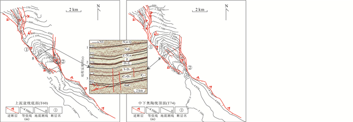
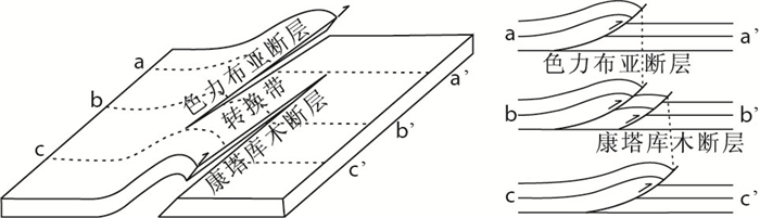
Based on the interpretation of the new drilling and seismic data, the structural characteristics of the Selibuya fault and Kangtakumu fault, which are the boundary faults between the western Bachu uplift and Maigaiti slope, are analyzed in this paper. The Selibuya and Kangtakumu faults are basement-involved thrust faults interacting by soft-linkage. Along the SE strike, the displacement of the Selibuya fault gradually decreases, while the displacement of the Kangtakumu fault increases. The transform zone between the two faults transferred their displacements, and kept the conservation of fault displacements in western part of the Bachu Uplift. The transform zone belongs to the synthetic overlapping zone which is in the evolution stage of complex. There are much secondary faults and fractures, which is good basis for the formation of fractured-type reservoirs and hydrocarbon migration. The transform zone is the favorable objective for petroleum exploration in the Bachu area.
Based on the interpretation of the new drilling and seismic data, the structural characteristics of the Selibuya fault and Kangtakumu fault, which are the boundary faults between the western Bachu uplift and Maigaiti slope, are analyzed in this paper. The Selibuya and Kangtakumu faults are basement-involved thrust faults interacting by soft-linkage. Along the SE strike, the displacement of the Selibuya fault gradually decreases, while the displacement of the Kangtakumu fault increases. The transform zone between the two faults transferred their displacements, and kept the conservation of fault displacements in western part of the Bachu Uplift. The transform zone belongs to the synthetic overlapping zone which is in the evolution stage of complex. There are much secondary faults and fractures, which is good basis for the formation of fractured-type reservoirs and hydrocarbon migration. The transform zone is the favorable objective for petroleum exploration in the Bachu area.


2013, 38(3): 581-591.
doi: 10.3799/dqkx.2013.058
Abstract:
The upper Yangtze platform of South China is rich in marine oil and gas. As located in different tectonic zones, its adjacent areas have distinct deformation styles, which leads to various cap rock and preservation conditions of marine hydrocarbon. Based on revealing the Meso-Cenozoic tectonic deformation characteristics of Sanjiang region in upper Yangtze block, and combined with the evolution of lithofacies and hydrocarbon accumulation factors, this paper discusses on the process that post-tectonic events controls on the distribution of marine hydrocarbon and formation of low mature oil & gas in plateau. It is suggested that early marine source-reservior-cap assemblages were destructed in Indo-China movement which resulted in growth of new reservoir forming assemblages in foreland subsidence as well. During the time of Yansinan movement, the basin rifting led to marine-flooding lacustrine mudstone deposition, not only acting as excellent source rocks, but also as regional cap rocks. From Cretaceous to Paleogene, the reservoir rocks of Jingxing Formation (K1j) and plaster rock grew in the process of basin atrophy. The critical cover of plaster rock is very important to marine over mature cracked gas. After Neogene, the strong strike-slip activity and plateau uplift has been unfavorable to the later preservation of the marine oil and gas, controlling the formation of a series of small mountain intermittent depression basin which are rich in land-based sources and aquatic organic matter, and the source rock are subjected to microbial degradation, generated immature-low mature oil and gas in low thermo evolution stage. This type of oil and gas resources is limited, but it provides a reference for the low evolution oil and gas exploration of the Tibetan Plateau.
The upper Yangtze platform of South China is rich in marine oil and gas. As located in different tectonic zones, its adjacent areas have distinct deformation styles, which leads to various cap rock and preservation conditions of marine hydrocarbon. Based on revealing the Meso-Cenozoic tectonic deformation characteristics of Sanjiang region in upper Yangtze block, and combined with the evolution of lithofacies and hydrocarbon accumulation factors, this paper discusses on the process that post-tectonic events controls on the distribution of marine hydrocarbon and formation of low mature oil & gas in plateau. It is suggested that early marine source-reservior-cap assemblages were destructed in Indo-China movement which resulted in growth of new reservoir forming assemblages in foreland subsidence as well. During the time of Yansinan movement, the basin rifting led to marine-flooding lacustrine mudstone deposition, not only acting as excellent source rocks, but also as regional cap rocks. From Cretaceous to Paleogene, the reservoir rocks of Jingxing Formation (K1j) and plaster rock grew in the process of basin atrophy. The critical cover of plaster rock is very important to marine over mature cracked gas. After Neogene, the strong strike-slip activity and plateau uplift has been unfavorable to the later preservation of the marine oil and gas, controlling the formation of a series of small mountain intermittent depression basin which are rich in land-based sources and aquatic organic matter, and the source rock are subjected to microbial degradation, generated immature-low mature oil and gas in low thermo evolution stage. This type of oil and gas resources is limited, but it provides a reference for the low evolution oil and gas exploration of the Tibetan Plateau.


2013, 38(3): 592-598.
doi: 10.3799/dqkx.2013.059
Abstract:
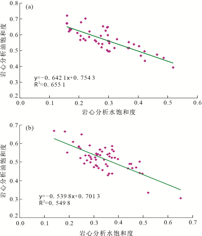
The analysis of oil-water saturation from sealed core wells is important data for evaluation of oil-bearing property of reservoirs. However, the oil-water saturation values from core measuring in laboratory usually deviate from true situation of original formation condition, so these data must be corrected before using. In this paper, the Kexia Group reservoir of First-Middle block in Karamay oilfield is selected as the study object. Firstly, based on the theoretical mode of oil-water saturation the relationship between oil-water saturation under original formation condition and oil-water saturation of sealed core analysis are studied according to the concept of oil-water remaining rate, and then the linear relationship of oil-water saturation values of sealed core analysis and oil-water remaining rate are determined. Based on the slope and intercept of above linear relationship the oil and water loss percentage in total loss of oil-water saturation are respectively established by use of mathematical statistics and mathematical processing methods. Finally, the saturation data can be effectively corrected by oil and water loss percentage. The above-mentioned method is applied to oil-water saturation correction in Kexia Group reservoir and achieves good application results. The using of corrected saturation data greatly improves correlation between core oil-bearing and reservoir electricity and corrected data can better reflect the oil-bearing situation of original formation, then provides accurate basic data for the saturation formula determination and remaining oil evaluation.
The analysis of oil-water saturation from sealed core wells is important data for evaluation of oil-bearing property of reservoirs. However, the oil-water saturation values from core measuring in laboratory usually deviate from true situation of original formation condition, so these data must be corrected before using. In this paper, the Kexia Group reservoir of First-Middle block in Karamay oilfield is selected as the study object. Firstly, based on the theoretical mode of oil-water saturation the relationship between oil-water saturation under original formation condition and oil-water saturation of sealed core analysis are studied according to the concept of oil-water remaining rate, and then the linear relationship of oil-water saturation values of sealed core analysis and oil-water remaining rate are determined. Based on the slope and intercept of above linear relationship the oil and water loss percentage in total loss of oil-water saturation are respectively established by use of mathematical statistics and mathematical processing methods. Finally, the saturation data can be effectively corrected by oil and water loss percentage. The above-mentioned method is applied to oil-water saturation correction in Kexia Group reservoir and achieves good application results. The using of corrected saturation data greatly improves correlation between core oil-bearing and reservoir electricity and corrected data can better reflect the oil-bearing situation of original formation, then provides accurate basic data for the saturation formula determination and remaining oil evaluation.


2013, 38(3): 599-606.
doi: 10.3799/dqkx.2013.060
Abstract:
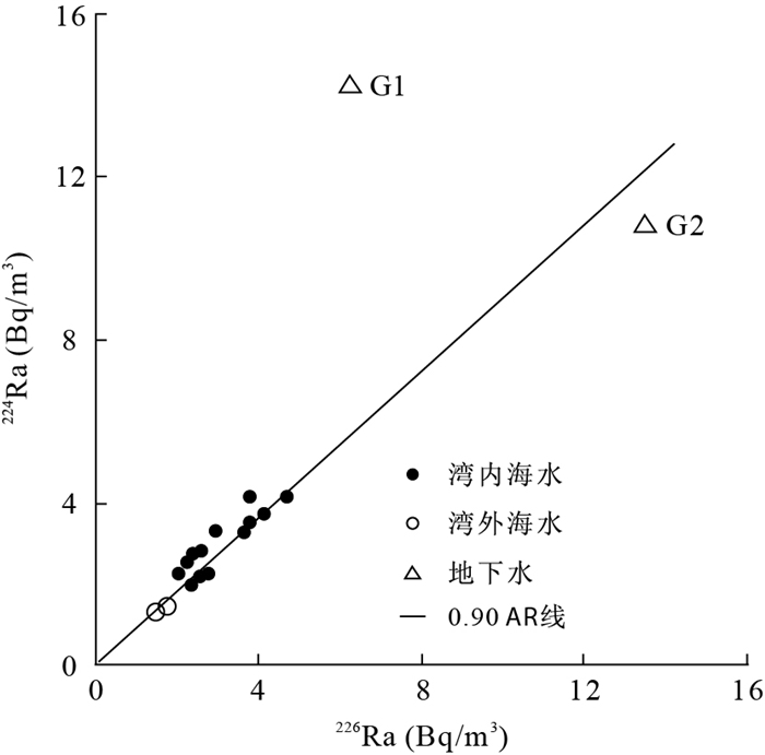
It's very difficult to measure submarine groundwater discharge (SGD) directly, but naturally occurring radium isotopes and radon tracers make it possible to estimate SGD fluxes indirectly. In order to evaluate the residence time of seawater and SGD fluxes in Wuyuan Bay, Xiamen, China, we measured the 224Ra and 226Ra activities in the bay water, open ocean seawater and groundwater, calculated the water parcel ages and average residence time in the Bay based on the differences in half-life between 224Ra and 226Ra, and estimated the SGD fluxes via the mass balance on 224Ra and 226Ra. The water parcel ages range from 0.6 to 2.4 d among thirteen sampling stations, with an average residence time of 1.4 d. The water parcel ages in the bay head relatively get older than those in the bay mouth. The calculated 224Ra and 226Ra fluxes driven by SGD are 5.17×10⁶ Bq/d and 5.28×10⁶ Bq/d, respectively. Both radium fluxes are further converted into SGD fluxes by dividing the activities of groundwater end-member to be 0.21 m3/m2/d (224Ra mass balance model) and 0.23 m3/m2/d (226Ra mass balance model), respectively. The calculated results from two models are so close that their average of 0.22 m3/m2/d can be considered as SGD fluxes in Wuyuan Bay.
It's very difficult to measure submarine groundwater discharge (SGD) directly, but naturally occurring radium isotopes and radon tracers make it possible to estimate SGD fluxes indirectly. In order to evaluate the residence time of seawater and SGD fluxes in Wuyuan Bay, Xiamen, China, we measured the 224Ra and 226Ra activities in the bay water, open ocean seawater and groundwater, calculated the water parcel ages and average residence time in the Bay based on the differences in half-life between 224Ra and 226Ra, and estimated the SGD fluxes via the mass balance on 224Ra and 226Ra. The water parcel ages range from 0.6 to 2.4 d among thirteen sampling stations, with an average residence time of 1.4 d. The water parcel ages in the bay head relatively get older than those in the bay mouth. The calculated 224Ra and 226Ra fluxes driven by SGD are 5.17×10⁶ Bq/d and 5.28×10⁶ Bq/d, respectively. Both radium fluxes are further converted into SGD fluxes by dividing the activities of groundwater end-member to be 0.21 m3/m2/d (224Ra mass balance model) and 0.23 m3/m2/d (226Ra mass balance model), respectively. The calculated results from two models are so close that their average of 0.22 m3/m2/d can be considered as SGD fluxes in Wuyuan Bay.


2013, 38(3): 607-615.
doi: 10.3799/dqkx.2013.061
Abstract:
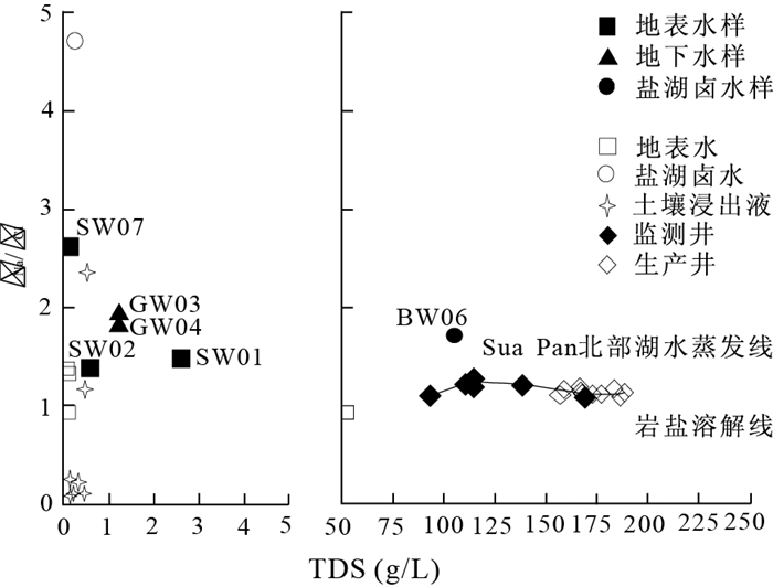
The salt lake of Sua Pan, one of the largest salt lakes in Botswana, is important resources of natural alkali. To identify the sources and genesis of subsurface brine in this salt lake, groundwater and surface water near this lake, in addition to subsurface brine water in the lake and salt crystals from solar salt field were collected and determined. The contents of major cation and anion, the isotope compositions of D, 18O and 37Cl, and the 14C age of groundwater were calculated. It is found that the subsurface brine is characterized by enriched Na and K, and depleted Ca and Mg. Results of D, 18O and 37Cl show that surface water is closely connected with subsurface brine in Sua Pan, while the role of groundwater recharge on it is weak (the difference of 37Cl is 0.04‰-0.06‰). Relationships of TDS-γNa/γCl indicate that leaching of halite affects the formation of this subsurface brine (γNa/γCl≈1), and the age of 14C (about 20 000 years ago)indicates that the fluctuation of ancient climate is considered to be an important factor of the formation of Sua Pan. Based on the above knowledge, inverse simulation of subsurface brine in Sua Pan is modeled by PHREEQC software, which further verifies that salt lake of Sua Pan is mainly the result of strong evaporation and concentration of surface water and halite leaching by groundwater.
The salt lake of Sua Pan, one of the largest salt lakes in Botswana, is important resources of natural alkali. To identify the sources and genesis of subsurface brine in this salt lake, groundwater and surface water near this lake, in addition to subsurface brine water in the lake and salt crystals from solar salt field were collected and determined. The contents of major cation and anion, the isotope compositions of D, 18O and 37Cl, and the 14C age of groundwater were calculated. It is found that the subsurface brine is characterized by enriched Na and K, and depleted Ca and Mg. Results of D, 18O and 37Cl show that surface water is closely connected with subsurface brine in Sua Pan, while the role of groundwater recharge on it is weak (the difference of 37Cl is 0.04‰-0.06‰). Relationships of TDS-γNa/γCl indicate that leaching of halite affects the formation of this subsurface brine (γNa/γCl≈1), and the age of 14C (about 20 000 years ago)indicates that the fluctuation of ancient climate is considered to be an important factor of the formation of Sua Pan. Based on the above knowledge, inverse simulation of subsurface brine in Sua Pan is modeled by PHREEQC software, which further verifies that salt lake of Sua Pan is mainly the result of strong evaporation and concentration of surface water and halite leaching by groundwater.


2013, 38(3): 616-624.
doi: 10.3799/dqkx.2013.062
Abstract:
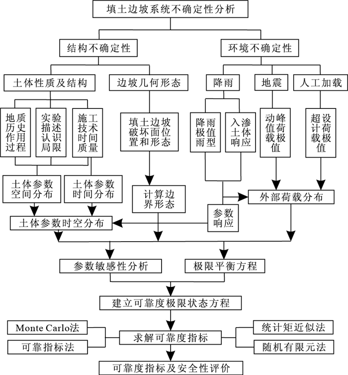
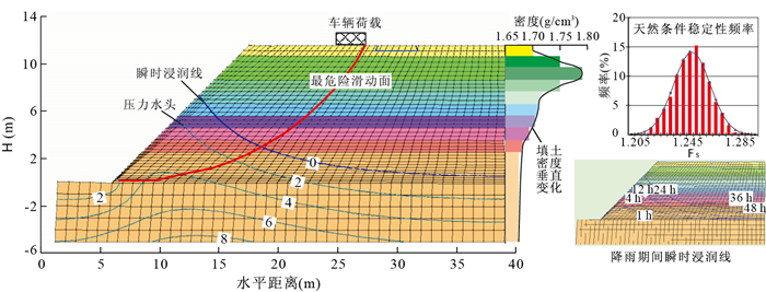
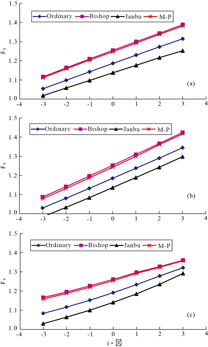
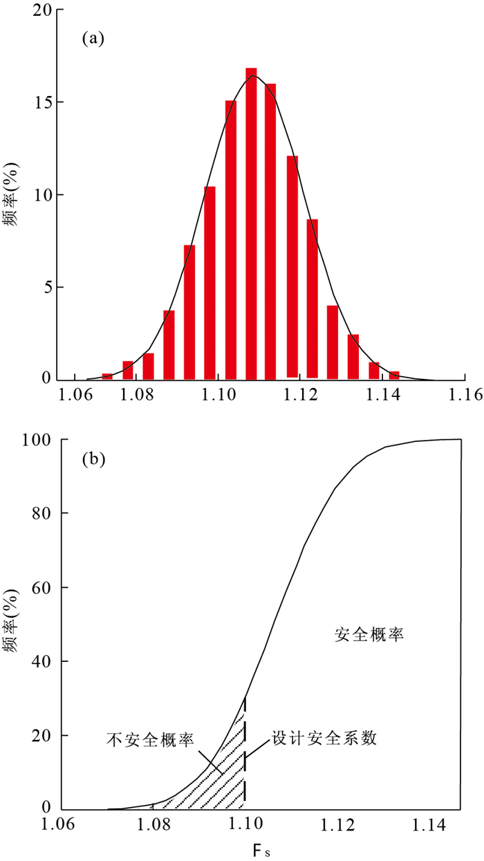
In order to analyze reliability of the stability of fill slopes, first, uncertain factors of stability of slope are discussed on the basis of the reliability theory. Then, the basic process of reliability analysis of fill slope is established, considering multi-variables. Finally, we apply the proposed method to analyze typical fill slope in manganese mine located at Ertang village, Pingle county, Guangxi. Results show that the fill slope uncertainties include two aspects, namely, internal structure and environmental factors. The former is due to the uncertainty of soil and slope geometric characteristics, and the latter is due to the rainfall, earthquakes, artificial load and so on. The reliability analysis contains three steps including analyzing uncertainty of fill slope, establishing the equation of reliability analysis, calculating reliability index and evaluating slope safety. The sensitivity factors for analyzing slope stability is internal friction angle Φ > cohesion C > vehicle load F. When Considering the maximum rainfall of 50 years return period, the stability is lowest at 12 h in one rain course. Its reliability index (β) is 8.79 and the failure probability is 0. According to the safety factor of criterion, the safe probability of the fill slope is 69.84%.
In order to analyze reliability of the stability of fill slopes, first, uncertain factors of stability of slope are discussed on the basis of the reliability theory. Then, the basic process of reliability analysis of fill slope is established, considering multi-variables. Finally, we apply the proposed method to analyze typical fill slope in manganese mine located at Ertang village, Pingle county, Guangxi. Results show that the fill slope uncertainties include two aspects, namely, internal structure and environmental factors. The former is due to the uncertainty of soil and slope geometric characteristics, and the latter is due to the rainfall, earthquakes, artificial load and so on. The reliability analysis contains three steps including analyzing uncertainty of fill slope, establishing the equation of reliability analysis, calculating reliability index and evaluating slope safety. The sensitivity factors for analyzing slope stability is internal friction angle Φ > cohesion C > vehicle load F. When Considering the maximum rainfall of 50 years return period, the stability is lowest at 12 h in one rain course. Its reliability index (β) is 8.79 and the failure probability is 0. According to the safety factor of criterion, the safe probability of the fill slope is 69.84%.


2013, 38(3): 625-631.
doi: 10.3799/dqkx.2013.063
Abstract:
Huangtupo landslide is one of the four largest landslides in the Three Gorges Reservoir area, where the Badong field laboratory is built by Three Gorges Research Center for Geo-hazards, Ministry of Education because it is typical and significant. The geological structure characteristics and formation mechanism of Huangtupo landslide can be clarified by exposing slope structure through the test tunnel excavation. Up to now, the geological structure of No.1 part slide exposed by the test tunnel excavation yield the following results: (1) In the bedrock of the No.1 part slide, the incompetent interlayers develop widely. (2) The excavation of the main test tunnel and the No.3 subsidiary test tunnel reveal that the displaced materials are composed of reddish brown mudstone and siltstone gravels, gray marlite and limestone gravels, and various crack strata. The ground water of the displaced materials is rich and the amount of water seepage is large. (3) The surfaces of rupture develop along the incompetent interlayers and the contacting surface between the stratum and the soil. The distribution of the surfaces of rupture in plane is very close to that obtained in previous studies. However, there exist some differences in the depth of the rupture surfaces. (4) The displacement monitoring data of deep boreholes show that there are creep displacements at the incompetent interlayers and the contacting surface between the stratum and the soil. Therefore, it can be concluded that the No.1 part slide crept along the incompetent interlayers and the contacting surface between the stratum and the soil under the long-term influence of tectonism and gravity, and the No.1 part slide has several surfaces of rupture.
Huangtupo landslide is one of the four largest landslides in the Three Gorges Reservoir area, where the Badong field laboratory is built by Three Gorges Research Center for Geo-hazards, Ministry of Education because it is typical and significant. The geological structure characteristics and formation mechanism of Huangtupo landslide can be clarified by exposing slope structure through the test tunnel excavation. Up to now, the geological structure of No.1 part slide exposed by the test tunnel excavation yield the following results: (1) In the bedrock of the No.1 part slide, the incompetent interlayers develop widely. (2) The excavation of the main test tunnel and the No.3 subsidiary test tunnel reveal that the displaced materials are composed of reddish brown mudstone and siltstone gravels, gray marlite and limestone gravels, and various crack strata. The ground water of the displaced materials is rich and the amount of water seepage is large. (3) The surfaces of rupture develop along the incompetent interlayers and the contacting surface between the stratum and the soil. The distribution of the surfaces of rupture in plane is very close to that obtained in previous studies. However, there exist some differences in the depth of the rupture surfaces. (4) The displacement monitoring data of deep boreholes show that there are creep displacements at the incompetent interlayers and the contacting surface between the stratum and the soil. Therefore, it can be concluded that the No.1 part slide crept along the incompetent interlayers and the contacting surface between the stratum and the soil under the long-term influence of tectonism and gravity, and the No.1 part slide has several surfaces of rupture.


2013, 38(3): 632-640.
doi: 10.3799/dqkx.2013.064
Abstract:
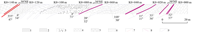
In order to understand the activity characteristics of the Fukang fault in Late-Quaternary, and accurately estimate the seismic hazard of the fault, a geological survey has been conducted along the Fukang fault. By surveying the deformation micro-topography, excavating two large paleoearthquake trenches, and dating a series of samples of thermoluminescence, the quantity activity characteristics of the Ganhezi fault segment of the Fukang fault belt are revealed. The Ganhezi fault segment is a Holocene active fault, with a total length about 33 km. The fault activity is obvious, generating a series of apparent geomorphic traces on the surface. Since the Late-Quaternary, the average vertical slip rate of fault is about 0.34-0.43 mm/a. Since the Mid-Holocene, there were two paleoearthquake events; the strong earthquake recurrence period of the fualt segment is about 2 100-3 750 a. The vertical surface displacement is about 1.5 m and the elapsed time is 4.11 ka of the latest paleoearthquake, corresponding to the paleoearthquake magnitude of between Ms7.2-7.4. The fault has accumulated a high energy so far.
In order to understand the activity characteristics of the Fukang fault in Late-Quaternary, and accurately estimate the seismic hazard of the fault, a geological survey has been conducted along the Fukang fault. By surveying the deformation micro-topography, excavating two large paleoearthquake trenches, and dating a series of samples of thermoluminescence, the quantity activity characteristics of the Ganhezi fault segment of the Fukang fault belt are revealed. The Ganhezi fault segment is a Holocene active fault, with a total length about 33 km. The fault activity is obvious, generating a series of apparent geomorphic traces on the surface. Since the Late-Quaternary, the average vertical slip rate of fault is about 0.34-0.43 mm/a. Since the Mid-Holocene, there were two paleoearthquake events; the strong earthquake recurrence period of the fualt segment is about 2 100-3 750 a. The vertical surface displacement is about 1.5 m and the elapsed time is 4.11 ka of the latest paleoearthquake, corresponding to the paleoearthquake magnitude of between Ms7.2-7.4. The fault has accumulated a high energy so far.


2013, 38(3): 641-648.
doi: 10.3799/dqkx.2013.065
Abstract:
China is the earliest country to study Danxia landforms in the world. "China Danxia", as a geomorphic term, has been recognized by the world with the successful declaration of "China Danxia" world natural heritage. This paper analyzes and discusses the formation conditions and process of Danxia landforms in Baishishan of Guiping, Guangxi on the basis of studying of its spatial distribution and landscape features. The study comes to the following conclusion: (1) Danxia geomorphology is typical and centralized, with its types complete and landscapes unique, having representative Danxia landforms characteristics of "flat tops, steep bodies, slow foothills"; (2) Danxia landforms is sedimentary red clastic rock deposited in intermountain basin in Neogene, which was formed through the inner and outer dynamic action of tectonic movement, such as basin uplift, erosion, dissolution, water cut and gravitational collapse; (3) Danxia geomorphology with the characteristics of new era of strata sedimentation and magnificent shape is rare among all the Danxia landforms in the world, which has high scientific value.
China is the earliest country to study Danxia landforms in the world. "China Danxia", as a geomorphic term, has been recognized by the world with the successful declaration of "China Danxia" world natural heritage. This paper analyzes and discusses the formation conditions and process of Danxia landforms in Baishishan of Guiping, Guangxi on the basis of studying of its spatial distribution and landscape features. The study comes to the following conclusion: (1) Danxia geomorphology is typical and centralized, with its types complete and landscapes unique, having representative Danxia landforms characteristics of "flat tops, steep bodies, slow foothills"; (2) Danxia landforms is sedimentary red clastic rock deposited in intermountain basin in Neogene, which was formed through the inner and outer dynamic action of tectonic movement, such as basin uplift, erosion, dissolution, water cut and gravitational collapse; (3) Danxia geomorphology with the characteristics of new era of strata sedimentation and magnificent shape is rare among all the Danxia landforms in the world, which has high scientific value.


2013, 38(3): 649-654.
doi: 10.3799/dqkx.2013.066
Abstract:
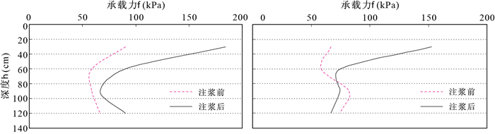
Dams are mainly located at the deep alluvium, where large amount of sand and gravel is adverse to prevention of seepage and maintenance of stability of the dams. Therefore it is necessary to reinforce the dams by grouting, and the primary task is to do research on the laws of diffusion and distribution of the slurry in the alluvial layer. The present study is based on the traditional theory of grouting and the laws of diffusion and distribution of the slurry, the slurry splitting mechanism, the characteristics of soil reinforcement are obtained. In addition, it is found by on-site grouting model tests that the slurry is generally filling and splitting along the interface between the earth and rock, and mainly splitting in the horizontal direction in grouting reinforcement process. To improve the reinforcement effect, the repeated injection should be adopted in grouting process. The study results will facilitate future dam grouting reinforcement projects in alluvial layer.
Dams are mainly located at the deep alluvium, where large amount of sand and gravel is adverse to prevention of seepage and maintenance of stability of the dams. Therefore it is necessary to reinforce the dams by grouting, and the primary task is to do research on the laws of diffusion and distribution of the slurry in the alluvial layer. The present study is based on the traditional theory of grouting and the laws of diffusion and distribution of the slurry, the slurry splitting mechanism, the characteristics of soil reinforcement are obtained. In addition, it is found by on-site grouting model tests that the slurry is generally filling and splitting along the interface between the earth and rock, and mainly splitting in the horizontal direction in grouting reinforcement process. To improve the reinforcement effect, the repeated injection should be adopted in grouting process. The study results will facilitate future dam grouting reinforcement projects in alluvial layer.