2013 Vol. 38, No. 4
Display Method:
 PDF 518KB
2013, 38(4): 663-676.
doi: 10.3799/dqkx.2013.067
Abstract:
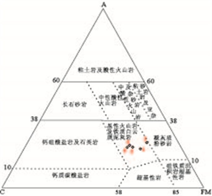
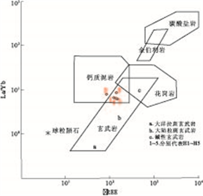
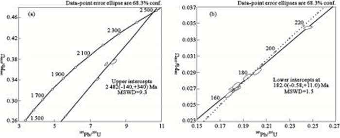
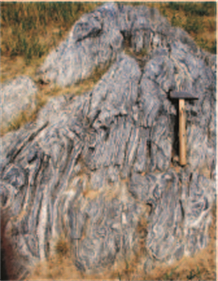
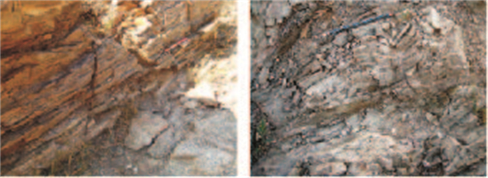
Located at the central of the Anning River discordogenic fault, the binding site of the Songpan-Ganze orogenic belt and the Yangtze block, Dashuigou schiefer has attracted increasing attention of researchers regarding to its special tectonic site and the occurred tellurium deposit. In order to provide chronologic evidences for reconstructing tectonic and magmatic geochronic evolution of areas around Dashuigou and the western margin of the Yangtze block in Shichuan, as well as for locating time of Dashuigou schiefer, zircon ages of the greenschist from Dashuigou were determined by SHRIMP U-Pb dating technique. Five age groups of the zircons with different characteristics of inner texture and cosmetics are obtained and subdivided from the greenschist of Dashuigou schiefer which should contain great proportions of sediments in the protolith. Ages of 2467-2430Ma from remained detrital magma zircons shows the mass transportation of Archaean-early proterozoic basement, whereas ages of 790.5-762.5Ma probably represent the magmatic event around Dashuigou on the background of Rodinia crack and upwelling mantle in early neoproterozoic. Metamorphism and magmation generated by orogenics and post orogenics are documented by ages of 696.8-642.9Ma from the magmatic zircons. Zircons of 262.0-220.0Ma ages are inferred to have been originated from alkalic rock nearby related to the Emeishan movement.216.5-167.1Ma ages of typical new growth and re-crystallized zircons caused by hydrothermal alteration reveal the post-magmatic hydrothermal activity. Dashuigou schiefer is probably allochthonic thrust sheet, and ages from magma zircons and those thermal genetics bound its general locating time to the interval from 220.0Ma to 167.1Ma.
Located at the central of the Anning River discordogenic fault, the binding site of the Songpan-Ganze orogenic belt and the Yangtze block, Dashuigou schiefer has attracted increasing attention of researchers regarding to its special tectonic site and the occurred tellurium deposit. In order to provide chronologic evidences for reconstructing tectonic and magmatic geochronic evolution of areas around Dashuigou and the western margin of the Yangtze block in Shichuan, as well as for locating time of Dashuigou schiefer, zircon ages of the greenschist from Dashuigou were determined by SHRIMP U-Pb dating technique. Five age groups of the zircons with different characteristics of inner texture and cosmetics are obtained and subdivided from the greenschist of Dashuigou schiefer which should contain great proportions of sediments in the protolith. Ages of 2467-2430Ma from remained detrital magma zircons shows the mass transportation of Archaean-early proterozoic basement, whereas ages of 790.5-762.5Ma probably represent the magmatic event around Dashuigou on the background of Rodinia crack and upwelling mantle in early neoproterozoic. Metamorphism and magmation generated by orogenics and post orogenics are documented by ages of 696.8-642.9Ma from the magmatic zircons. Zircons of 262.0-220.0Ma ages are inferred to have been originated from alkalic rock nearby related to the Emeishan movement.216.5-167.1Ma ages of typical new growth and re-crystallized zircons caused by hydrothermal alteration reveal the post-magmatic hydrothermal activity. Dashuigou schiefer is probably allochthonic thrust sheet, and ages from magma zircons and those thermal genetics bound its general locating time to the interval from 220.0Ma to 167.1Ma.


2013, 22(4): 663-676.
doi: 10.3799/dqkx.2013.067
Abstract:
Located at the central of the Anning River discordogenic fault, the binding site of the Songpan-Ganze orogenic belt and the Yangtze block, Dashuigou schiefer has attracted increasing attention of researchers regarding to its special tectonic site and the occurred tellurium deposit. In order to provide chronologic evidences for reconstructing tectonic and magmatic geochronic evolution of areas around Dashuigou and the western margin of the Yangtze block in Shichuan, as well as for locating time of Dashuigou schiefer, zircon ages of the greenschist from Dashuigou were determined by SHRIMP U-Pb dating technique. Five age groups of the zircons with different characteristics of inner texture and cosmetics are obtained and subdivided from the greenschist of Dashuigou schiefer which should contain great proportions of sediments in the protolith. Ages of 2467-2430Ma from remained detrital magma zircons shows the mass transportation of Archaean-early proterozoic basement, whereas ages of 790.5-762.5Ma probably represent the magmatic event around Dashuigou on the background of Rodinia crack and upwelling mantle in early neoproterozoic. Metamorphism and magmation generated by orogenics and post orogenics are documented by ages of 696.8-642.9Ma from the magmatic zircons. Zircons of 262.0-220.0Ma ages are inferred to have been originated from alkalic rock nearby related to the Emeishan movement.216.5-167.1Ma ages of typical new growth and re-crystallized zircons caused by hydrothermal alteration reveal the post-magmatic hydrothermal activity. Dashuigou schiefer is probably allochthonic thrust sheet, and ages from magma zircons and those thermal genetics bound its general locating time to the interval from 220.0Ma to 167.1Ma.
Located at the central of the Anning River discordogenic fault, the binding site of the Songpan-Ganze orogenic belt and the Yangtze block, Dashuigou schiefer has attracted increasing attention of researchers regarding to its special tectonic site and the occurred tellurium deposit. In order to provide chronologic evidences for reconstructing tectonic and magmatic geochronic evolution of areas around Dashuigou and the western margin of the Yangtze block in Shichuan, as well as for locating time of Dashuigou schiefer, zircon ages of the greenschist from Dashuigou were determined by SHRIMP U-Pb dating technique. Five age groups of the zircons with different characteristics of inner texture and cosmetics are obtained and subdivided from the greenschist of Dashuigou schiefer which should contain great proportions of sediments in the protolith. Ages of 2467-2430Ma from remained detrital magma zircons shows the mass transportation of Archaean-early proterozoic basement, whereas ages of 790.5-762.5Ma probably represent the magmatic event around Dashuigou on the background of Rodinia crack and upwelling mantle in early neoproterozoic. Metamorphism and magmation generated by orogenics and post orogenics are documented by ages of 696.8-642.9Ma from the magmatic zircons. Zircons of 262.0-220.0Ma ages are inferred to have been originated from alkalic rock nearby related to the Emeishan movement.216.5-167.1Ma ages of typical new growth and re-crystallized zircons caused by hydrothermal alteration reveal the post-magmatic hydrothermal activity. Dashuigou schiefer is probably allochthonic thrust sheet, and ages from magma zircons and those thermal genetics bound its general locating time to the interval from 220.0Ma to 167.1Ma.
2013, 38(4): 677-688.
doi: 10.3799/dqkx.2013.068
Abstract:
Major and trace elements analysis and LA-ICP-MS zircon U-Pb ages show Toudao, Laoling, Shanglvshuiqiao and Gaotaizi plutons are Early Cretaceous aluminum A-type granites in the Laoling area, South of Jilin Province.Plutons mainly consist of k-feldspar granite, miarolitic k-feldspar granite, granite porphyry and granites.The results of LA-ICP-MS dating are (121-125) Ma.The major elements of granitoids are high in Si, alk and low in Fe, Mg, Ca, and Ti.Trace elements are enriched in incompatible elements such as K, Rb, Th and depleted in Ba, Sr, Ti, Nb, Ta, and P.The granitoids have right-wing type of chondrite-normalized REE patterns and moderate negative Eu anomalies.Geochemical features indicate that granitoids are aluminum A-type granites (A/CNK=(0.82-1.15), A/NK=(1.00-1.28)).Granitoids with relatively low incompatible element ratio values such as Ce/Nb, Y/Nb and Yb/Ta are A1-type anorogenic granite.The formation of A1-type granite indicates Laoling area is in the Anorogenic extensional tectonic setting during Early Cretaceous.
Major and trace elements analysis and LA-ICP-MS zircon U-Pb ages show Toudao, Laoling, Shanglvshuiqiao and Gaotaizi plutons are Early Cretaceous aluminum A-type granites in the Laoling area, South of Jilin Province.Plutons mainly consist of k-feldspar granite, miarolitic k-feldspar granite, granite porphyry and granites.The results of LA-ICP-MS dating are (121-125) Ma.The major elements of granitoids are high in Si, alk and low in Fe, Mg, Ca, and Ti.Trace elements are enriched in incompatible elements such as K, Rb, Th and depleted in Ba, Sr, Ti, Nb, Ta, and P.The granitoids have right-wing type of chondrite-normalized REE patterns and moderate negative Eu anomalies.Geochemical features indicate that granitoids are aluminum A-type granites (A/CNK=(0.82-1.15), A/NK=(1.00-1.28)).Granitoids with relatively low incompatible element ratio values such as Ce/Nb, Y/Nb and Yb/Ta are A1-type anorogenic granite.The formation of A1-type granite indicates Laoling area is in the Anorogenic extensional tectonic setting during Early Cretaceous.


2013, 38(4): 689-714.
doi: 10.3799/dqkx.2013.069
Abstract:
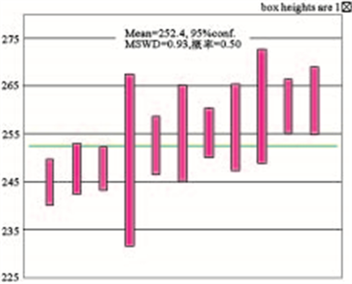
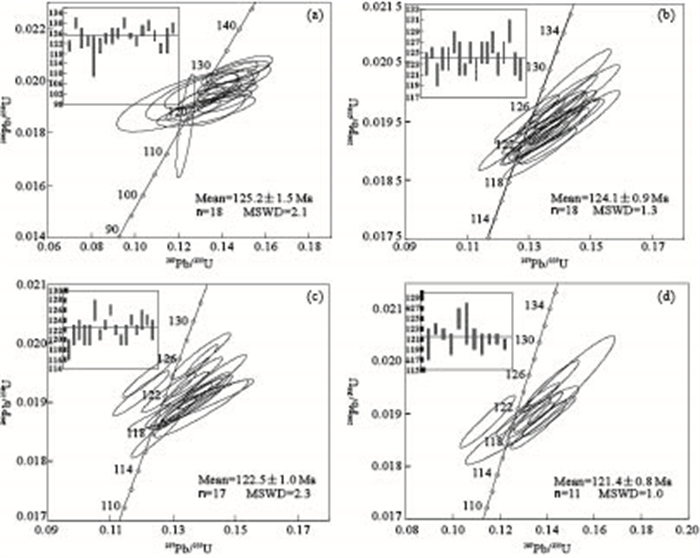
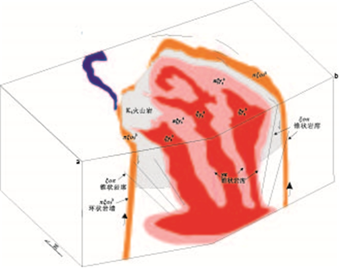
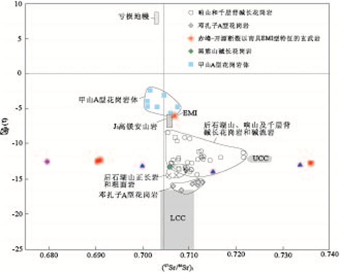
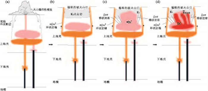
The Houshihushan complex is an alkaline ring complex associated with a collapsed caldera, consisting of a circular screen of alkaline volcanic rocks and post-collapse resurgent intrusions including a ring dyke of porphyritic quartz syenite, a central composite hypabyssal intrusion of nested stocks of drusy alkali-feldspar granite and porphyritic alkali-feldspar granite, and cone sheets of quartz syenite porphyry and granite porphyry. Zircon LA-ICPMS U-Pb analyses yields mean 206Pb/238U ages of 119±3Ma for porphyritic quartz syenite, 121±2Ma for quartz syenite and 121±2Ma for granite porphyry, respectively. Volcanic rocks of the Houshihushan Ring Complex (HRC) have similar ages to those of the intrusive rocks, confirming it as a volcanic-intrusive complex. Porphyritic quartz syenites have high contents of Na2O+K2O (10.0%-10.5%) and K2O (5.21%-5.42%) with positive Eu anomalies (Eu/Eu*=1.05-1.40). Alkali-feldspar granites and porphyries are characterized by enriched Na2O+K2O, FeOtot/MgO, Ga/Al, Zr, Nb and REE (except for Eu) and low abundance of Al2O3, CaO, MgO, Ba, Sr and Eu, indicative of A-type granitic rocks. The porphyries can be classified as aluminous A-type granites, and show high zircon saturation temperatures (880-901℃). All the A-type granites of the HRC posses negative εNd(t) values from -13.9 to -12.2. Porphyritic quartz syenite magmas were derived from partial melting of intermediate to mafic granulites and gneisses in the lower crust that mixed with enriched mantle-derived basaltic magma, with subsequent differentiation of clinopyroxene. Alkali-feldspar granite magmas were produced by mixing of mantle-derived basaltic magmas with upper crustal felsic melts, with fractionation of feldspars. The petrogenetic processes of porphyritic magmas involved partial melting of quartzfeldspathic rocks at shallow crust depths coupled with differentiation of feldspars. We suggest that development of the HRC involved the following four-stage sequence: (1) massive alkaline laves and pyroclastics erupted explosively; (2) the subsided caldera formed because of loss of magma from an underlying magma chamber which reduced magma pressure and facilitated collapse of the roof of the magma chamber along near-vertical ring faults. Magma intruded passively up the opening ring-faults to form the ring dyke of porphyritic quartz syenite during caldera collapse; (3) the high-level magma chamer became overpressured, and hot peralkline A-type granite magma was emplaced as the central stock of porphyritic alkali-feldspar granite. The overlying crust was fractured to generate cone fractures that provided space for the ascent of felsic melts to form cone sheets of quartz syenite porphyry; (4) the chamber resurged and a cogenetic pluton was emplaced as the nested stock of drusy alkali-feldspar granite. Build-up of magma overpressure within the central source chamber imparted upward force to fracture the host rock and form new conical fractures. These fractures were filled with magma to form cone sheets of granite porphyry. The Houshihushan alkaline ring complex formed over a brief time period in an extensional setting related to destruction of the eastern North China Craton during Early Cretaceous, possibly associated with subduction of paleo-Pacific plate.
The Houshihushan complex is an alkaline ring complex associated with a collapsed caldera, consisting of a circular screen of alkaline volcanic rocks and post-collapse resurgent intrusions including a ring dyke of porphyritic quartz syenite, a central composite hypabyssal intrusion of nested stocks of drusy alkali-feldspar granite and porphyritic alkali-feldspar granite, and cone sheets of quartz syenite porphyry and granite porphyry. Zircon LA-ICPMS U-Pb analyses yields mean 206Pb/238U ages of 119±3Ma for porphyritic quartz syenite, 121±2Ma for quartz syenite and 121±2Ma for granite porphyry, respectively. Volcanic rocks of the Houshihushan Ring Complex (HRC) have similar ages to those of the intrusive rocks, confirming it as a volcanic-intrusive complex. Porphyritic quartz syenites have high contents of Na2O+K2O (10.0%-10.5%) and K2O (5.21%-5.42%) with positive Eu anomalies (Eu/Eu*=1.05-1.40). Alkali-feldspar granites and porphyries are characterized by enriched Na2O+K2O, FeOtot/MgO, Ga/Al, Zr, Nb and REE (except for Eu) and low abundance of Al2O3, CaO, MgO, Ba, Sr and Eu, indicative of A-type granitic rocks. The porphyries can be classified as aluminous A-type granites, and show high zircon saturation temperatures (880-901℃). All the A-type granites of the HRC posses negative εNd(t) values from -13.9 to -12.2. Porphyritic quartz syenite magmas were derived from partial melting of intermediate to mafic granulites and gneisses in the lower crust that mixed with enriched mantle-derived basaltic magma, with subsequent differentiation of clinopyroxene. Alkali-feldspar granite magmas were produced by mixing of mantle-derived basaltic magmas with upper crustal felsic melts, with fractionation of feldspars. The petrogenetic processes of porphyritic magmas involved partial melting of quartzfeldspathic rocks at shallow crust depths coupled with differentiation of feldspars. We suggest that development of the HRC involved the following four-stage sequence: (1) massive alkaline laves and pyroclastics erupted explosively; (2) the subsided caldera formed because of loss of magma from an underlying magma chamber which reduced magma pressure and facilitated collapse of the roof of the magma chamber along near-vertical ring faults. Magma intruded passively up the opening ring-faults to form the ring dyke of porphyritic quartz syenite during caldera collapse; (3) the high-level magma chamer became overpressured, and hot peralkline A-type granite magma was emplaced as the central stock of porphyritic alkali-feldspar granite. The overlying crust was fractured to generate cone fractures that provided space for the ascent of felsic melts to form cone sheets of quartz syenite porphyry; (4) the chamber resurged and a cogenetic pluton was emplaced as the nested stock of drusy alkali-feldspar granite. Build-up of magma overpressure within the central source chamber imparted upward force to fracture the host rock and form new conical fractures. These fractures were filled with magma to form cone sheets of granite porphyry. The Houshihushan alkaline ring complex formed over a brief time period in an extensional setting related to destruction of the eastern North China Craton during Early Cretaceous, possibly associated with subduction of paleo-Pacific plate.


Redefinition and Significance of Metamorphism Xilinhot Group in Xilinhot Area, Inner Mongolia, China
2013, 38(4): 715-724.
doi: 10.3799/dqkx.2013.070
Abstract:
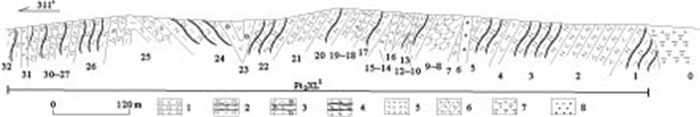
Based on large scale geologic mapping and measuring section, the Xilin Gol complex is divided into three parts: supracrustal rock, Late Proterozoic basic-ultrabasic rock and Early Paleozoic acid intrusive rocks. According to lithologic association and characteristics of deformation and metamorphism, biotite (garnet) plagioclase gneiss intercalated with several layers barred amphibolite, with thin layer magnetite quartzite on its top; medium-coarse biotite plagioclase gneiss and fine-grained felsic gneiss; lithologic association of migmatization banding biotite (hornblende) plagioclase gneiss and garnet monzonitic gneiss intercalated with barred amphibolite; sillimanite biotite plagioclase gneiss, barred biotite plagioclase gneiss, intercalated with garnet bearing biotite quartz schist. Comparison study on the different lithologic association, metamorphic characteristics and depositional environment of Baoyintu Group, Ailegemiao Formatio, Bainaimiao Group and others. This paper proposes to redefine these supercrustal rocks named "Xilinhot Group", which compose the Precambrian metamorphic basement of Xilin Gol micro block. It's important to study the formation and development of Xilin Gol micro block and the evolution of structural relationship between Siberia plate and North China plate.
Based on large scale geologic mapping and measuring section, the Xilin Gol complex is divided into three parts: supracrustal rock, Late Proterozoic basic-ultrabasic rock and Early Paleozoic acid intrusive rocks. According to lithologic association and characteristics of deformation and metamorphism, biotite (garnet) plagioclase gneiss intercalated with several layers barred amphibolite, with thin layer magnetite quartzite on its top; medium-coarse biotite plagioclase gneiss and fine-grained felsic gneiss; lithologic association of migmatization banding biotite (hornblende) plagioclase gneiss and garnet monzonitic gneiss intercalated with barred amphibolite; sillimanite biotite plagioclase gneiss, barred biotite plagioclase gneiss, intercalated with garnet bearing biotite quartz schist. Comparison study on the different lithologic association, metamorphic characteristics and depositional environment of Baoyintu Group, Ailegemiao Formatio, Bainaimiao Group and others. This paper proposes to redefine these supercrustal rocks named "Xilinhot Group", which compose the Precambrian metamorphic basement of Xilin Gol micro block. It's important to study the formation and development of Xilin Gol micro block and the evolution of structural relationship between Siberia plate and North China plate.


2013, 38(4): 725-744.
doi: 10.3799/dqkx.2013.071
Abstract:
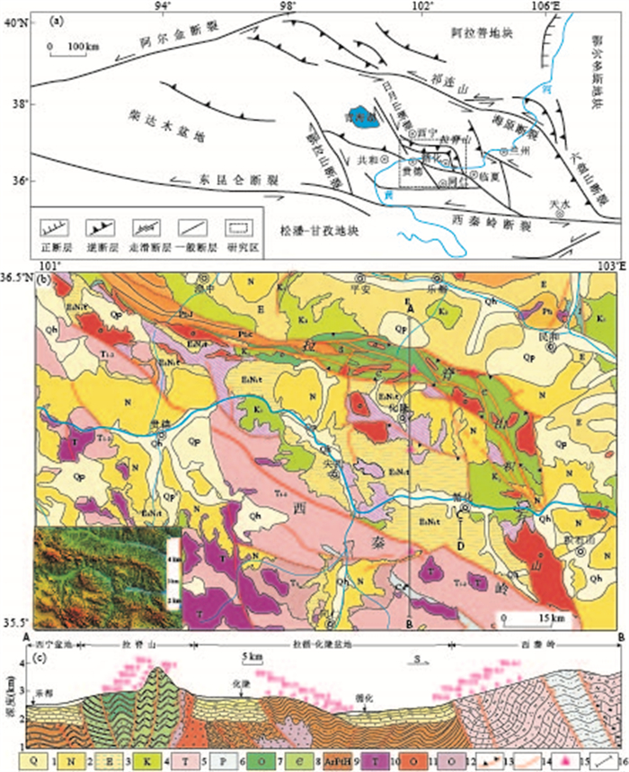
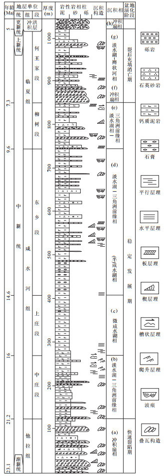
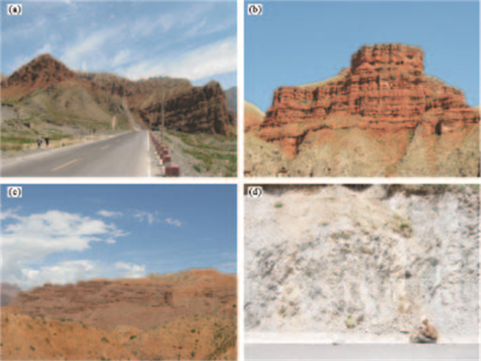
Xunhua-Hualong basin Cenozoic sedimentary strata, basement and surrounding mountains analysis of apatite fission track geochronology reveals the Northeast margin of Qinghai-Tibet plateau experienced three periods of uplift and exhumation events since Late Cretaceous: (1) Basin basement, Laji mountain and West Qinling orogenic belt apatite fission track ages generally record a Late Cretaceous-Eocene relatively rapid regional uplift and exhumation event. Northern margin of West Qinling rapidly uplift at 84Ma, which was controlled by the uplift of the northward thrust; to the North Lamu Gorge in central of Xunhua-Hualong basin uplift at 69Ma; further north rapid uplift stages along Laji mountain is mainly between 40-50Ma, reflecting Paleocene-Eocene rapid uplift gradually extending from south to north. This tectonic uplift event resulted in Xunhua-Hualong basin and Linxia basin missing Paleogene Xining group sedimentary strata that deposits in northern Xining-Minhe basin. The first period of uplift and exhumation ended at about 31Ma, when Xunhua-Hualong basin connected with eastern Linxia basin to a large unified foreland basin of West Qinling, both experience the same tectonic and sedimentary evolution history, therefore Cenozoic oldest Tala group sedimentary strata age in Xunhua-Hualong basin won't exceed the oldest sedimentary strata with Paleomagnetic age of 29Ma in Linxia basin. (2) Late Oligocene about 26Ma Laji mountain began bi-directionally thrust-uplift and may have continued to Early Miocene about 21Ma, and uplifting made Xunhua-Hualong basin become piedmont extrusion foreland basin between Laji mountain and West Qinling, when Xunhua-Hualong basin began to deposit Tala group alluvial fan of thick coarse clastic rocks. By analyzing sedimentary facies, the ancient flow direction and gravel composition of Xianshuihe group and Linxia group sedimentary strata in Xunhua-Hualong basin, it is concluded that Laji mountains experienced the largest bi-directional thrust-uplift event in the Miocene about 8Ma, which led directly to the event of Xunhua-Hualong piedmont extrusion foreland basin turning into mountain basin, which formed basic pattern of basin-mountain landform in northeastern margin of Qinghai-Tibet plateau nowadays.
Xunhua-Hualong basin Cenozoic sedimentary strata, basement and surrounding mountains analysis of apatite fission track geochronology reveals the Northeast margin of Qinghai-Tibet plateau experienced three periods of uplift and exhumation events since Late Cretaceous: (1) Basin basement, Laji mountain and West Qinling orogenic belt apatite fission track ages generally record a Late Cretaceous-Eocene relatively rapid regional uplift and exhumation event. Northern margin of West Qinling rapidly uplift at 84Ma, which was controlled by the uplift of the northward thrust; to the North Lamu Gorge in central of Xunhua-Hualong basin uplift at 69Ma; further north rapid uplift stages along Laji mountain is mainly between 40-50Ma, reflecting Paleocene-Eocene rapid uplift gradually extending from south to north. This tectonic uplift event resulted in Xunhua-Hualong basin and Linxia basin missing Paleogene Xining group sedimentary strata that deposits in northern Xining-Minhe basin. The first period of uplift and exhumation ended at about 31Ma, when Xunhua-Hualong basin connected with eastern Linxia basin to a large unified foreland basin of West Qinling, both experience the same tectonic and sedimentary evolution history, therefore Cenozoic oldest Tala group sedimentary strata age in Xunhua-Hualong basin won't exceed the oldest sedimentary strata with Paleomagnetic age of 29Ma in Linxia basin. (2) Late Oligocene about 26Ma Laji mountain began bi-directionally thrust-uplift and may have continued to Early Miocene about 21Ma, and uplifting made Xunhua-Hualong basin become piedmont extrusion foreland basin between Laji mountain and West Qinling, when Xunhua-Hualong basin began to deposit Tala group alluvial fan of thick coarse clastic rocks. By analyzing sedimentary facies, the ancient flow direction and gravel composition of Xianshuihe group and Linxia group sedimentary strata in Xunhua-Hualong basin, it is concluded that Laji mountains experienced the largest bi-directional thrust-uplift event in the Miocene about 8Ma, which led directly to the event of Xunhua-Hualong piedmont extrusion foreland basin turning into mountain basin, which formed basic pattern of basin-mountain landform in northeastern margin of Qinghai-Tibet plateau nowadays.


2013, 38(4): 745-754.
doi: 10.3799/dqkx.2013.072
Abstract:
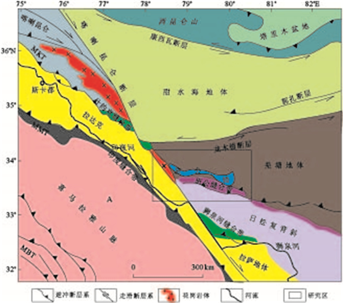
Causes and tectonic evolution of Bangong lake basin are studied based on the results of geological survey, fluvial sedimentary natures, the age of deposition and its distribution law, referring to ETM+ remote sensing interpretation about tectonics and Quaternary sedimentary strata. Analysis of topography, sedimentary and tectonics indicates that Bangong lake basin is a pull-apart faulted basin; according to activity characteristics of the faults around the lake basin and sedimentary response, the evolution of lake basin is devided into four stages: infancy of lake basin open (later than the early Miocene), adolescence of basin expansion (8.1±1Ma), maturity of rapid expansion of the lake basin with lake basin center moving south (later than 0.94Ma) and gerontic age of lake basin asymmetric atrophy (later than 0.23Ma).
Causes and tectonic evolution of Bangong lake basin are studied based on the results of geological survey, fluvial sedimentary natures, the age of deposition and its distribution law, referring to ETM+ remote sensing interpretation about tectonics and Quaternary sedimentary strata. Analysis of topography, sedimentary and tectonics indicates that Bangong lake basin is a pull-apart faulted basin; according to activity characteristics of the faults around the lake basin and sedimentary response, the evolution of lake basin is devided into four stages: infancy of lake basin open (later than the early Miocene), adolescence of basin expansion (8.1±1Ma), maturity of rapid expansion of the lake basin with lake basin center moving south (later than 0.94Ma) and gerontic age of lake basin asymmetric atrophy (later than 0.23Ma).


2013, 38(4): 755-762.
doi: 10.3799/dqkx.2013.073
Abstract:
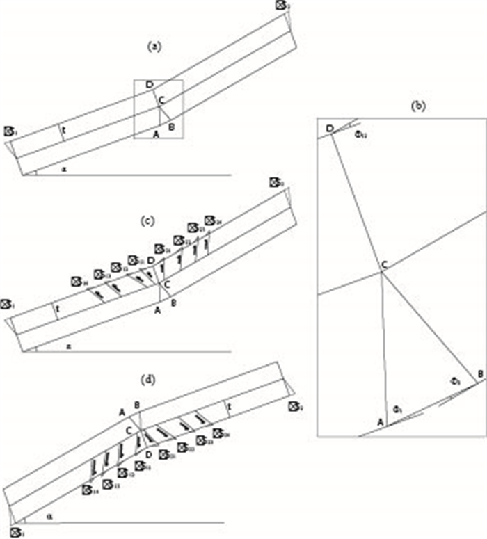
To explore the relationship between the formation of fractures and the deformation of strata, fractures data from outcrops in the Upper Jurassic strata of Lin'an are integrated with geometry modeling in this study. It is found that two main type fractures are secondary structures to the fold, which are referred to as fold accommodation fractures in this paper, and named as D and D' fractures respectively. An angle ranging 44°-80° exists between fractures and stratum layers, with D' fracture directing the motion of local layer and D fracture directing the motion of adjacent layer. The fractures formed primarily because of an increase in bed curvature within fold cores. The relationship between fracture density and layer thickness is established on the basis of geometrical analysis of the fold and we find that fractures density is proportional to the layer thickness.
To explore the relationship between the formation of fractures and the deformation of strata, fractures data from outcrops in the Upper Jurassic strata of Lin'an are integrated with geometry modeling in this study. It is found that two main type fractures are secondary structures to the fold, which are referred to as fold accommodation fractures in this paper, and named as D and D' fractures respectively. An angle ranging 44°-80° exists between fractures and stratum layers, with D' fracture directing the motion of local layer and D fracture directing the motion of adjacent layer. The fractures formed primarily because of an increase in bed curvature within fold cores. The relationship between fracture density and layer thickness is established on the basis of geometrical analysis of the fold and we find that fractures density is proportional to the layer thickness.


2013, 38(4): 763-775.
doi: 10.3799/dqkx.2013.074
Abstract:
Based on 210Pb data of 16 gravity core samples and from the previous study, the spatial pattern of sedimentation rates and its indication to distribution of Yangtze sediment supply in the Yangtze River estuary and its adjacent area were examined. The high accumulation rates were observed at the subaqueous delta off the south branch with the maximum value of 6.3cm/a, generally above 3cm/a. The second highest values distribute on the Hangzhou bay, about 1.7-3.0cm/a in north and much lower in south (0.4-1.0cm/a). Relative higher sedimentation rates, about 2.58cm/a, appear in the northwest of study area. The radial sand ridges along the north Jiangsu coastal line, delta-shelf transitional zone and continental shelf were characterized by low sedimentation rates (< 1cm/a), due to the strong hydrodynamic setting and lack of modern Changjiang material supply. As revealed by this study, a large amount of Yangtze sediment load is deposited around the subaqueous delta and the north Hangzhou Bay. The dispersion of modern Yangtze sediment to East China Sea is constrained to the west of 123°E. The relatively high sedimentation rate in north continental area is mainly contributed by sediment eroded from the abandoned Yellow delta and suspended materials transported by Yellow Sea longshore currents.
Based on 210Pb data of 16 gravity core samples and from the previous study, the spatial pattern of sedimentation rates and its indication to distribution of Yangtze sediment supply in the Yangtze River estuary and its adjacent area were examined. The high accumulation rates were observed at the subaqueous delta off the south branch with the maximum value of 6.3cm/a, generally above 3cm/a. The second highest values distribute on the Hangzhou bay, about 1.7-3.0cm/a in north and much lower in south (0.4-1.0cm/a). Relative higher sedimentation rates, about 2.58cm/a, appear in the northwest of study area. The radial sand ridges along the north Jiangsu coastal line, delta-shelf transitional zone and continental shelf were characterized by low sedimentation rates (< 1cm/a), due to the strong hydrodynamic setting and lack of modern Changjiang material supply. As revealed by this study, a large amount of Yangtze sediment load is deposited around the subaqueous delta and the north Hangzhou Bay. The dispersion of modern Yangtze sediment to East China Sea is constrained to the west of 123°E. The relatively high sedimentation rate in north continental area is mainly contributed by sediment eroded from the abandoned Yellow delta and suspended materials transported by Yellow Sea longshore currents.


2013, 38(4): 776-782.
doi: 10.3799/dqkx.2013.075
Abstract:
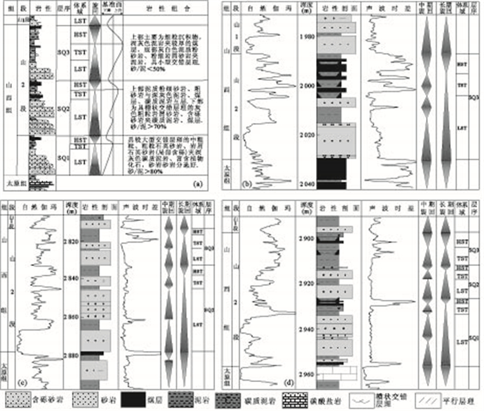
Intra-cratonic basins are the important hydrocarbon-bearing basins in China. However, the previous research of sequence stratigraphy is insufficient to intra-cratonic basin. Based on the sequence stratigraphic research of Shanxi Formation of Ordos basin, one typical intra-cratonic basins of China, the authors develop the source-ward retro-gradational stacking patterns with long-term retrogradation and short-term progradation. The model indicates that (1) sequence stratigraphic architecture of third-order sequence within intra-cratonic basins mainly consists of lowstand systems tract (LST), and lack of transgressive systems tract (TST) and highstand systems tract(HST); (2) the third-order base level cycle has the characteristics of long term transgression and short term regression; (3) the sand-bodies controlled by various order sequence stratigraphic framework show the model of source-ward retro-gradational stacking patterns from base to top.
Intra-cratonic basins are the important hydrocarbon-bearing basins in China. However, the previous research of sequence stratigraphy is insufficient to intra-cratonic basin. Based on the sequence stratigraphic research of Shanxi Formation of Ordos basin, one typical intra-cratonic basins of China, the authors develop the source-ward retro-gradational stacking patterns with long-term retrogradation and short-term progradation. The model indicates that (1) sequence stratigraphic architecture of third-order sequence within intra-cratonic basins mainly consists of lowstand systems tract (LST), and lack of transgressive systems tract (TST) and highstand systems tract(HST); (2) the third-order base level cycle has the characteristics of long term transgression and short term regression; (3) the sand-bodies controlled by various order sequence stratigraphic framework show the model of source-ward retro-gradational stacking patterns from base to top.


2013, 38(4): 783-791.
doi: 10.3799/dqkx.2013.076
Abstract:
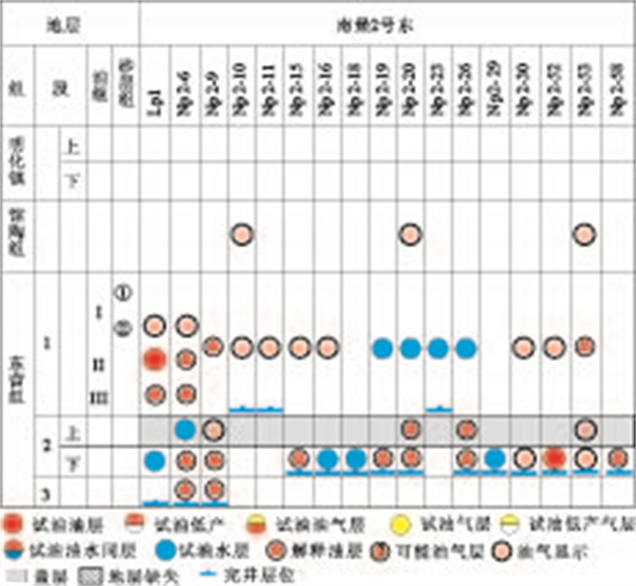
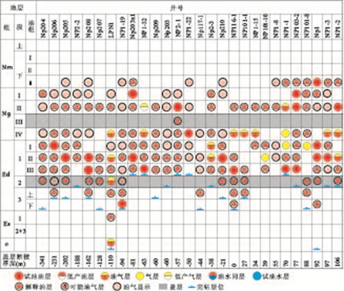
To study oil-gas accumulation law of middle and shallow strata in Nanpu depression, sealing of matching between fault and caprock to oil-gas migrating through faults was studied by the method contrasting between thickness of caprock and fault distance and analyzing the relation between it and oil-gas distribution. The results indicate that there are three grades sealing of regional caprock to oil-gas migration through faults: (1) when thickness of caprock is bigger than fault distance and faulted thickness of caprock is bigger than a fixed value, matching between fault and caprock can seal fully oil-gas migration through faults; (2) when thickness of caprock is less than fault distance and faulted thickness of caprock is less than a fixed value, matching between fault and caprock can partially seal oil-gas migration through faults; (3) when thickness of caprock is less than fault distance and faulted thickness of regional caprock is less than zero, matching between fault and caprock can not seal oil-gas migration through faults. Matching between faults and regional caprock of Ed2 and Ng3 both have a full, partial and no sealing to oil-gas migration through faults, and matching between faults and regional caprock of Nm1 has full sealing to oil-gas migration through faults in Nanpu depression. Controlling of relation of matching among sealing of matching between fault and three regional caprock to oil-gas migrating through faults to oil-gas accumulation horizons and areas is shown in following three aspects: (1) matching between faults and regional caprock of Ed2 in Nanpu2 region has full sealing, oil-gas distributes under it; (2) Matching between faults and regional caprock of Ed2 in Nanpu 1-5 block has partial or no sealing, but matching between faults and regional caprock of Ng3 has full sealing, oil-gas distributes mainl in Ed3 and Ng4; (3) Matching between faults and regional caprock of Ed2 and Ng3 in the part of Nanpu1 and Nanpu4 structures have partial or no sealing, but matching between faults and regional caprock of Nm1 has full sealing, oil-gas distributes from lower to upper.
To study oil-gas accumulation law of middle and shallow strata in Nanpu depression, sealing of matching between fault and caprock to oil-gas migrating through faults was studied by the method contrasting between thickness of caprock and fault distance and analyzing the relation between it and oil-gas distribution. The results indicate that there are three grades sealing of regional caprock to oil-gas migration through faults: (1) when thickness of caprock is bigger than fault distance and faulted thickness of caprock is bigger than a fixed value, matching between fault and caprock can seal fully oil-gas migration through faults; (2) when thickness of caprock is less than fault distance and faulted thickness of caprock is less than a fixed value, matching between fault and caprock can partially seal oil-gas migration through faults; (3) when thickness of caprock is less than fault distance and faulted thickness of regional caprock is less than zero, matching between fault and caprock can not seal oil-gas migration through faults. Matching between faults and regional caprock of Ed2 and Ng3 both have a full, partial and no sealing to oil-gas migration through faults, and matching between faults and regional caprock of Nm1 has full sealing to oil-gas migration through faults in Nanpu depression. Controlling of relation of matching among sealing of matching between fault and three regional caprock to oil-gas migrating through faults to oil-gas accumulation horizons and areas is shown in following three aspects: (1) matching between faults and regional caprock of Ed2 in Nanpu2 region has full sealing, oil-gas distributes under it; (2) Matching between faults and regional caprock of Ed2 in Nanpu 1-5 block has partial or no sealing, but matching between faults and regional caprock of Ng3 has full sealing, oil-gas distributes mainl in Ed3 and Ng4; (3) Matching between faults and regional caprock of Ed2 and Ng3 in the part of Nanpu1 and Nanpu4 structures have partial or no sealing, but matching between faults and regional caprock of Nm1 has full sealing, oil-gas distributes from lower to upper.


2013, 38(4): 792-796.
doi: 10.3799/dqkx.2013.077
Abstract:
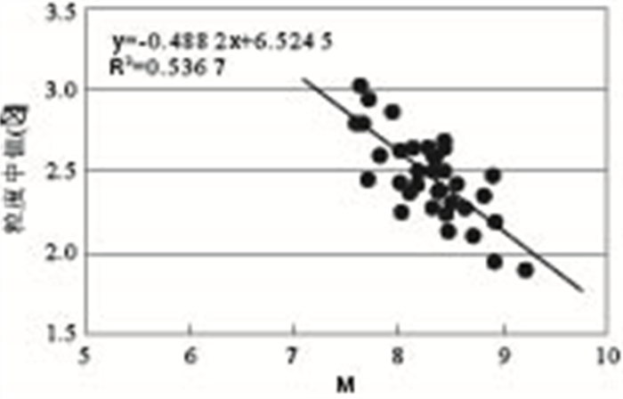
Rock particle-size and grading are the main features of sedimentary rocks, and also the main indicators to evaluate the deposition environment and ancient geographical analysis of the sediment. Meanwhile, it's also the controlling factors that influence sediment's diagenetic environment and physical property. Because of the widely use of PDC bit, there is a greater error between logging lithology and size grade, which has restricted the further development of geologic research. By utilizing GR, CNL, DEN, DT and resistivity curves, we abstract the parameters M, N, which is sensitive to particle size and lithology, and another parameters-the ratio of deep resistivity and shallow resistivity, combining with the particle-size analysis data of core. Then, we establish the inversion model for particle size of sediment through logging geology analysing. The field data processing and contrast of core data has proved this model feasible in inverting the sedimentary particle-size, and providing a sequential size graded profile.
Rock particle-size and grading are the main features of sedimentary rocks, and also the main indicators to evaluate the deposition environment and ancient geographical analysis of the sediment. Meanwhile, it's also the controlling factors that influence sediment's diagenetic environment and physical property. Because of the widely use of PDC bit, there is a greater error between logging lithology and size grade, which has restricted the further development of geologic research. By utilizing GR, CNL, DEN, DT and resistivity curves, we abstract the parameters M, N, which is sensitive to particle size and lithology, and another parameters-the ratio of deep resistivity and shallow resistivity, combining with the particle-size analysis data of core. Then, we establish the inversion model for particle size of sediment through logging geology analysing. The field data processing and contrast of core data has proved this model feasible in inverting the sedimentary particle-size, and providing a sequential size graded profile.


2013, 38(4): 797-806.
doi: 10.3799/dqkx.2013.078
Abstract:
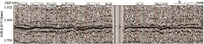
The relationship between T2 reflector fault and hydrocarbon accumulation reservoir of middle-shallow layer is close, which proves genetic mechanism of T2 reflector fault dense zones is important for hydrocarbon exploration. Based on the northern Songliao basin regional seismic interpretation, the analysis of the development characteristics and the formation and evolution of fault, we systematically analyze fault deformation mechanism at different stages, which reveal formation mechanism of T2 reflector fault dense zones and indication of hydrocarbon exploration. This study shows that T2 reflector fault dense zones have been formed through the following three preriods, namely, the initial faulted period, pre-structure in faulted period, and level detachment of plastic mudstone cap rock and EW tension stress field in Quanyi member. Stretch dense zones of SN tension stress mechanism dominates the region. Accommodation and strike slip accommodation dense zones of NE, NW and EW oblique stretch mechanism is fragmentary in distribution. Sinistral compresso-shear deformation field, half grabens during faulted period and basal huge faults jointly control the formation of subprime anticlines and structural inversion belts during reversed period, meanwhile, fault dense zones of structural inversion belts reform and setting as main NW-NNW by counterclockwise rotation. Edge fault in T2 reflector NW-NNW fault dense zones of structural inversion belts and SN fault dense zones of structural non-inversion belts are long-term activity, of which matches with hydrocarbon generation and expulsion phase in time. They are oil-migrating faults of hydrocarbon accumulation reservoir in middle-shallow layer.
The relationship between T2 reflector fault and hydrocarbon accumulation reservoir of middle-shallow layer is close, which proves genetic mechanism of T2 reflector fault dense zones is important for hydrocarbon exploration. Based on the northern Songliao basin regional seismic interpretation, the analysis of the development characteristics and the formation and evolution of fault, we systematically analyze fault deformation mechanism at different stages, which reveal formation mechanism of T2 reflector fault dense zones and indication of hydrocarbon exploration. This study shows that T2 reflector fault dense zones have been formed through the following three preriods, namely, the initial faulted period, pre-structure in faulted period, and level detachment of plastic mudstone cap rock and EW tension stress field in Quanyi member. Stretch dense zones of SN tension stress mechanism dominates the region. Accommodation and strike slip accommodation dense zones of NE, NW and EW oblique stretch mechanism is fragmentary in distribution. Sinistral compresso-shear deformation field, half grabens during faulted period and basal huge faults jointly control the formation of subprime anticlines and structural inversion belts during reversed period, meanwhile, fault dense zones of structural inversion belts reform and setting as main NW-NNW by counterclockwise rotation. Edge fault in T2 reflector NW-NNW fault dense zones of structural inversion belts and SN fault dense zones of structural non-inversion belts are long-term activity, of which matches with hydrocarbon generation and expulsion phase in time. They are oil-migrating faults of hydrocarbon accumulation reservoir in middle-shallow layer.


2013, 38(4): 807-818.
doi: 10.3799/dqkx.2013.079
Abstract:
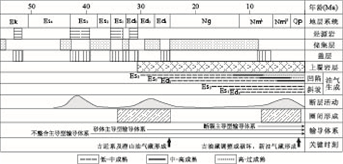
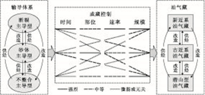
The geological evolution of the Bozhong sub-basin, characterized by rapid subsidence and strong fault activities since the initiation of the Dongying Formation, exerts important effect on the characteristics of hydrocarbon accumulation in this area, which is distinguished from those in other areas in the Bohai Bay Basin. Uplifts around depressions serve as predominant sites for hydrocarbon accumulation, and the distribution and evolution of pathway systems have obviously been controlling hydrocarbon migration and accumulation. Based on clarification of the distribution of hydrocarbon source rocks and petroleum resources in the large-scale Bozhong petroleum system, growing characteristics of all kinds of potential pathways and their spatial relevance are analyzed by means of multiple data, and then three pathway system types controlling hydrocarbon migration and accumulation: fault-dominant, carrier bed-dominant and unconformity-dominant types are identified. Long-term growth faults adjoining uplifts act as the predominant pathways for vertical fluid release and hydrocarbon migration, and control hydrocarbon accumulation in the Neogene reservoirs on uplifts. Especially in the active stage of tectonic movement, the open long-term growth faults must be preferential pathways for the rapid vertical hydrocarbon migration. The interconnected sandbodies in the Paleogene Shahejie and Dongying Formations, directly contacting with active hydrocarbon source rocks, serve as the primary sites and starting stations for the early and late hydrocarbon migration and accumulation, respectively. Therefore, they not only control hydrocarbon accumulation in the Paleogene traps, but also directly impact hydrocarbon supply to the Neogene trap on uplifts to some extent. Unconformity T8, resulted from regionally tectonic transformation in last Mesozoic, serve as pathway for deep lateral hydrocarbon migration and control hydrocarbon accumulation in the buried hill type reservoirs due to its improved permeability attributed to long-term weathering process. Three types of pathway systems all impact even control the times, locations, velocities and scales of hydrocarbon accumulation in various degrees. However, the fault-dominant type pathway system shows the most outstanding effect among them.
The geological evolution of the Bozhong sub-basin, characterized by rapid subsidence and strong fault activities since the initiation of the Dongying Formation, exerts important effect on the characteristics of hydrocarbon accumulation in this area, which is distinguished from those in other areas in the Bohai Bay Basin. Uplifts around depressions serve as predominant sites for hydrocarbon accumulation, and the distribution and evolution of pathway systems have obviously been controlling hydrocarbon migration and accumulation. Based on clarification of the distribution of hydrocarbon source rocks and petroleum resources in the large-scale Bozhong petroleum system, growing characteristics of all kinds of potential pathways and their spatial relevance are analyzed by means of multiple data, and then three pathway system types controlling hydrocarbon migration and accumulation: fault-dominant, carrier bed-dominant and unconformity-dominant types are identified. Long-term growth faults adjoining uplifts act as the predominant pathways for vertical fluid release and hydrocarbon migration, and control hydrocarbon accumulation in the Neogene reservoirs on uplifts. Especially in the active stage of tectonic movement, the open long-term growth faults must be preferential pathways for the rapid vertical hydrocarbon migration. The interconnected sandbodies in the Paleogene Shahejie and Dongying Formations, directly contacting with active hydrocarbon source rocks, serve as the primary sites and starting stations for the early and late hydrocarbon migration and accumulation, respectively. Therefore, they not only control hydrocarbon accumulation in the Paleogene traps, but also directly impact hydrocarbon supply to the Neogene trap on uplifts to some extent. Unconformity T8, resulted from regionally tectonic transformation in last Mesozoic, serve as pathway for deep lateral hydrocarbon migration and control hydrocarbon accumulation in the buried hill type reservoirs due to its improved permeability attributed to long-term weathering process. Three types of pathway systems all impact even control the times, locations, velocities and scales of hydrocarbon accumulation in various degrees. However, the fault-dominant type pathway system shows the most outstanding effect among them.


2013, 38(4): 819-831.
doi: 10.3799/dqkx.2013.080
Abstract:
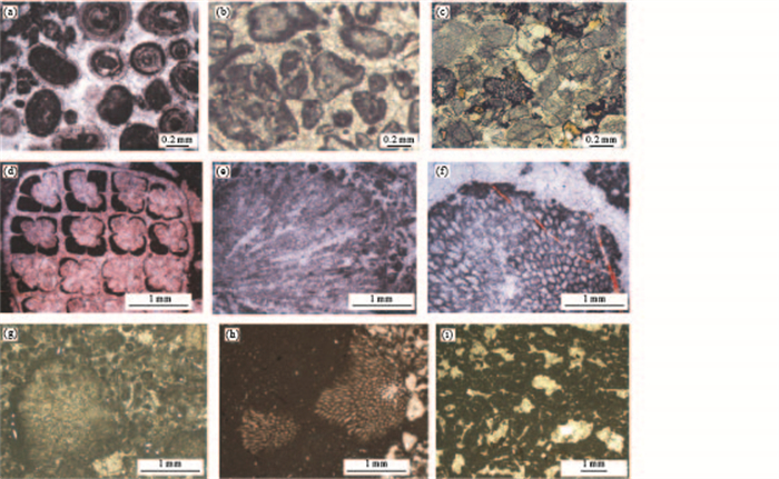
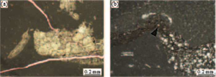
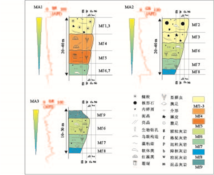
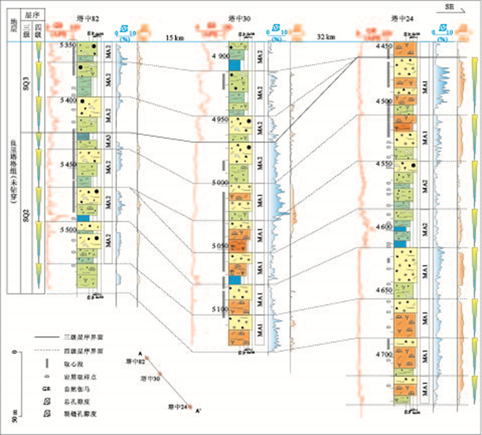
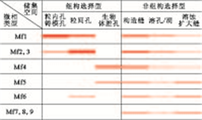
The Lianglitage Formation has been of great scientific interest for being the main reservoir for oil and gas in Tazhong area, Tarim basin. However, researches on depositional microfacies and their controls on reservoir quality are inadequate. Based on cores, thin-sections and well-logging data, detailed microfacies analysis, high-resolution sequences and controlling factors on favorable reservoir are studied in this paper. 9 microfacies (Mf1-Mf9) are recognized in carbonate platform and 3 microfacies associations(MA1-MA3) are established, which are interpreted as platform margin reef and sand bank, platform margin-interior sand bank, and platform interior peri-tidal types respectively. One or more microfacies associations can be developed within a fourth order sequence which is constrained by subordinated flood surface. Depositional model for HST of SQ2 is constructed, based on high-resolution sequences and microfacies analysis and their correlation between wells. The high energy microfacies are the primitive material for favorable reservoir, because they might have been more probably to be dissolved by meteoric water during penecontemporaneous diagenetic progress, and also more easily to be fractured. The reservoir quality of low energy microfacies could have been improved if tectonic fractures, burial dissolution and/or karstification developed.
The Lianglitage Formation has been of great scientific interest for being the main reservoir for oil and gas in Tazhong area, Tarim basin. However, researches on depositional microfacies and their controls on reservoir quality are inadequate. Based on cores, thin-sections and well-logging data, detailed microfacies analysis, high-resolution sequences and controlling factors on favorable reservoir are studied in this paper. 9 microfacies (Mf1-Mf9) are recognized in carbonate platform and 3 microfacies associations(MA1-MA3) are established, which are interpreted as platform margin reef and sand bank, platform margin-interior sand bank, and platform interior peri-tidal types respectively. One or more microfacies associations can be developed within a fourth order sequence which is constrained by subordinated flood surface. Depositional model for HST of SQ2 is constructed, based on high-resolution sequences and microfacies analysis and their correlation between wells. The high energy microfacies are the primitive material for favorable reservoir, because they might have been more probably to be dissolved by meteoric water during penecontemporaneous diagenetic progress, and also more easily to be fractured. The reservoir quality of low energy microfacies could have been improved if tectonic fractures, burial dissolution and/or karstification developed.


2013, 38(4): 832-842.
doi: 10.3799/dqkx.2013.081
Abstract:
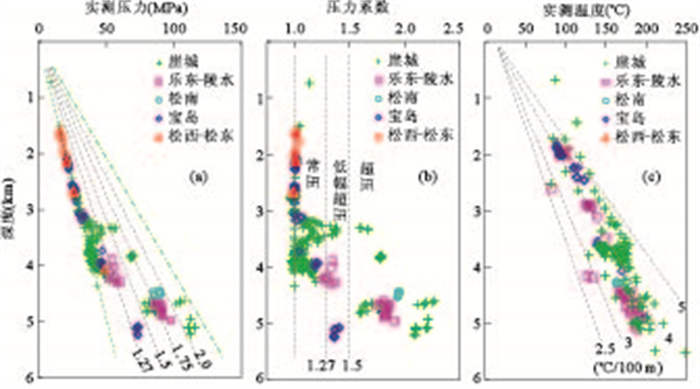
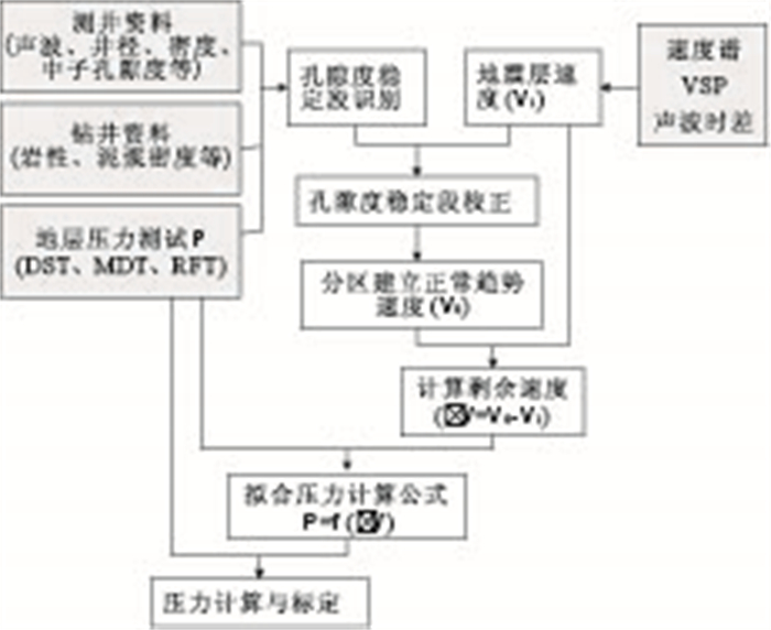
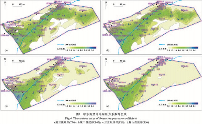
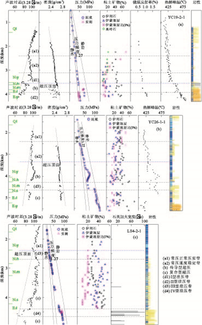
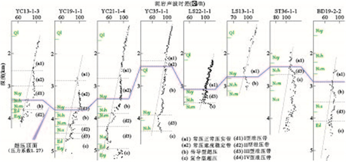
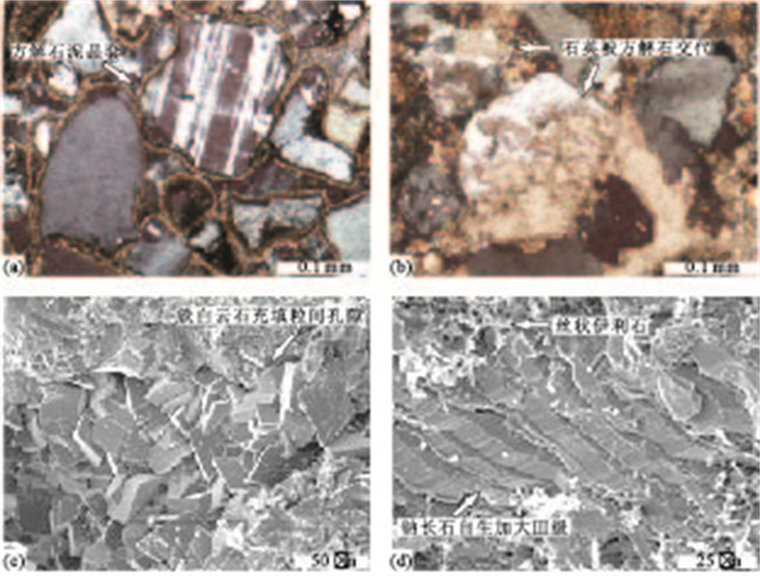
Discharging zones are channels for fluid to move out from inside the overpressure system and favorable sites for petroleum accumulation, which are of great significance to the accumulation of water-soluble gas by exsolution. The overpressure system distribution of Qiongdongnan basin is predicted and divided into three types based on the comprehensive analysis of the velocity spectrum, logging, drilling and formation test data. In addition, four types of discharging zones are identified according to the mineral analysis. The distribution of discharging zones and possible sites for petroleum accumulation are finally discussed. There exists only one overpressure system which is effected by the development of continental slop system and the pressure transfer from Yinggehai basin, the pressure along the slop belt is much stronger and the top surface of overpressure system in the west is shallower than that in the east. Accumulation of water soluble gas in the pressure discharging zones is totally determined by pressure, temperature and the amount of dissolved gas, and it is vital whether there is adequate amount of dissolved gas and sufficient changes in solubility.The accumulation conditions of type II discharging zone are the most favorable one, resulting in more active fluid activities. The favorable sites of type III discharging zone are distributed near the Lingshui low uplift and the northern slop of Baodao sag, along boundary faults and close to the normal pressure zone.
Discharging zones are channels for fluid to move out from inside the overpressure system and favorable sites for petroleum accumulation, which are of great significance to the accumulation of water-soluble gas by exsolution. The overpressure system distribution of Qiongdongnan basin is predicted and divided into three types based on the comprehensive analysis of the velocity spectrum, logging, drilling and formation test data. In addition, four types of discharging zones are identified according to the mineral analysis. The distribution of discharging zones and possible sites for petroleum accumulation are finally discussed. There exists only one overpressure system which is effected by the development of continental slop system and the pressure transfer from Yinggehai basin, the pressure along the slop belt is much stronger and the top surface of overpressure system in the west is shallower than that in the east. Accumulation of water soluble gas in the pressure discharging zones is totally determined by pressure, temperature and the amount of dissolved gas, and it is vital whether there is adequate amount of dissolved gas and sufficient changes in solubility.The accumulation conditions of type II discharging zone are the most favorable one, resulting in more active fluid activities. The favorable sites of type III discharging zone are distributed near the Lingshui low uplift and the northern slop of Baodao sag, along boundary faults and close to the normal pressure zone.


2013, 38(4): 843-852.
doi: 10.3799/dqkx.2013.082
Abstract:
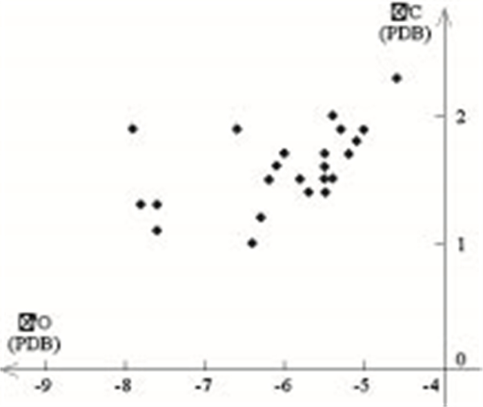
This paper focuses on the diagenetic environments of deep sandstones in the upper Es4 of the palaeogene in Lijin sag, where core samples are obtained. Microscopic observations, including light, fluorescent, and cathodoluminescence microscopy, as well as scanning electron microscopy, are carried out. The contents of clay mineral and some chemical composition are also detected. 2 types of diagenetic environment are classified. The acidic diagenetic environment is indicated by the dissolution of carbonates and feldspar, the development of kaolinite and autogenic quartz at the same time. The alkaline diagenetic environment is marked by feldspar overgrowth, carbonate cement and the dissolution of quartz at the same time. The evolution of diagenetic environment is discussed. Alkaline environment dominated the syndiagenetic stage, which was formed by the sedimentary salt water. Early diagenetic stage went through temporary acidic environment, formed by early hydrocarbon evolution, and mostly alkaline environment, formed by inherited alkaline fluid. The A1 period of middle diagenetic stage (in the depth of 2700-3200m) was dominated by acidic environment, formed by the organic maturation. The A2 period of middle diagenetic stage was dominated by alkaline environment, formed by the alkaline fluid from the deep fault. The B period of middle diagenetic stage was dominated by acidic environment, formed by the continued evolution of second filled oil.
This paper focuses on the diagenetic environments of deep sandstones in the upper Es4 of the palaeogene in Lijin sag, where core samples are obtained. Microscopic observations, including light, fluorescent, and cathodoluminescence microscopy, as well as scanning electron microscopy, are carried out. The contents of clay mineral and some chemical composition are also detected. 2 types of diagenetic environment are classified. The acidic diagenetic environment is indicated by the dissolution of carbonates and feldspar, the development of kaolinite and autogenic quartz at the same time. The alkaline diagenetic environment is marked by feldspar overgrowth, carbonate cement and the dissolution of quartz at the same time. The evolution of diagenetic environment is discussed. Alkaline environment dominated the syndiagenetic stage, which was formed by the sedimentary salt water. Early diagenetic stage went through temporary acidic environment, formed by early hydrocarbon evolution, and mostly alkaline environment, formed by inherited alkaline fluid. The A1 period of middle diagenetic stage (in the depth of 2700-3200m) was dominated by acidic environment, formed by the organic maturation. The A2 period of middle diagenetic stage was dominated by alkaline environment, formed by the alkaline fluid from the deep fault. The B period of middle diagenetic stage was dominated by acidic environment, formed by the continued evolution of second filled oil.


2013, 38(4): 853-858.
doi: 10.3799/dqkx.2013.083
Abstract:
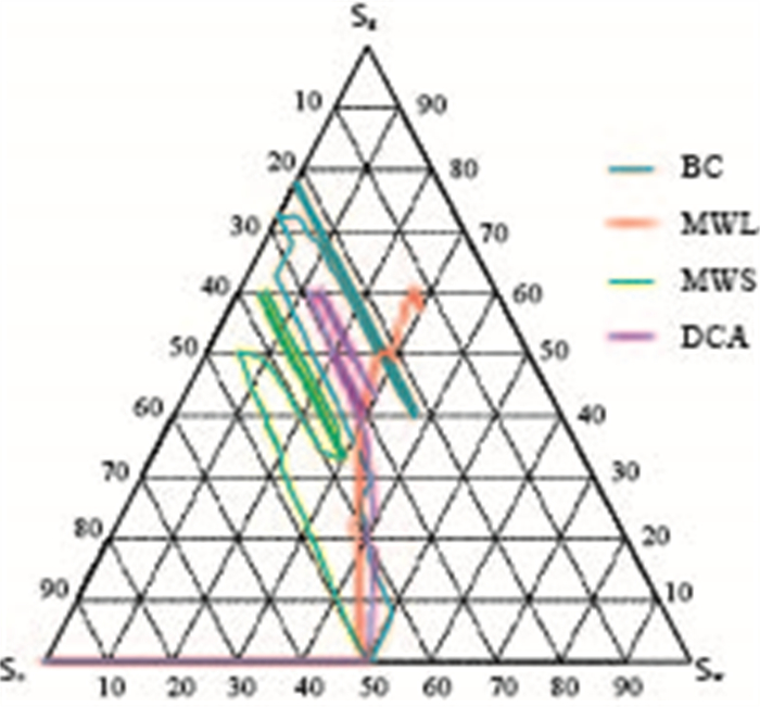
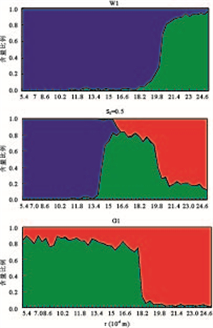
In order to better understand the pore-scale physics of three phase flow during water-alternating-gas (WAG) injection, we simulate the WAG process in different wettability systems based on a 3-D pore-scale network model in this study, and the saturation paths, occupancy statistics and displacement statistics are obtained. The results show that oil is almost displaced during the first 2 WAG cycles; then, saturation and occupancy statistics of fluids reach a steady condition; the existence of double and multiple displacement chains enhances oil recovery. The obtained fluid saturation variation, fluid distribution and displacement type during WAG give good interpretation for the micro displacement mechanism in porous media.
In order to better understand the pore-scale physics of three phase flow during water-alternating-gas (WAG) injection, we simulate the WAG process in different wettability systems based on a 3-D pore-scale network model in this study, and the saturation paths, occupancy statistics and displacement statistics are obtained. The results show that oil is almost displaced during the first 2 WAG cycles; then, saturation and occupancy statistics of fluids reach a steady condition; the existence of double and multiple displacement chains enhances oil recovery. The obtained fluid saturation variation, fluid distribution and displacement type during WAG give good interpretation for the micro displacement mechanism in porous media.


2013, 38(4): 859-869.
doi: 10.3799/dqkx.2013.084
Abstract:
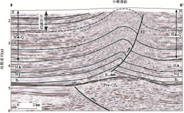
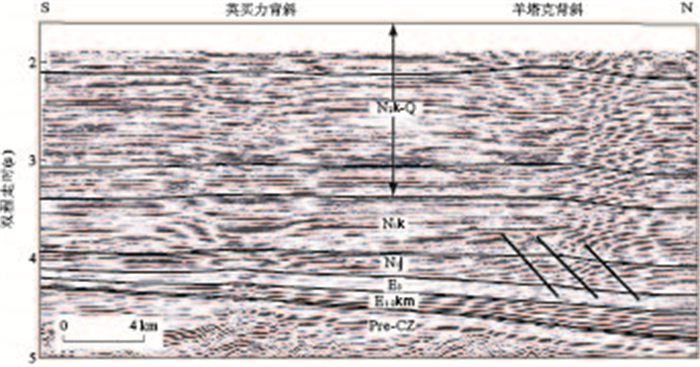
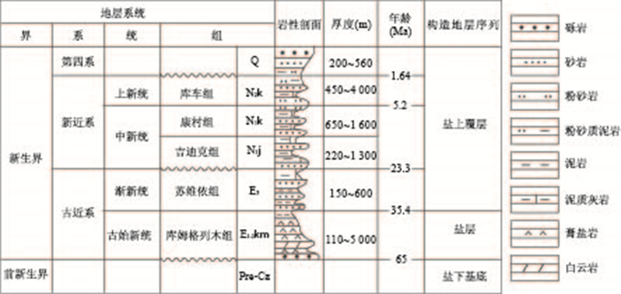
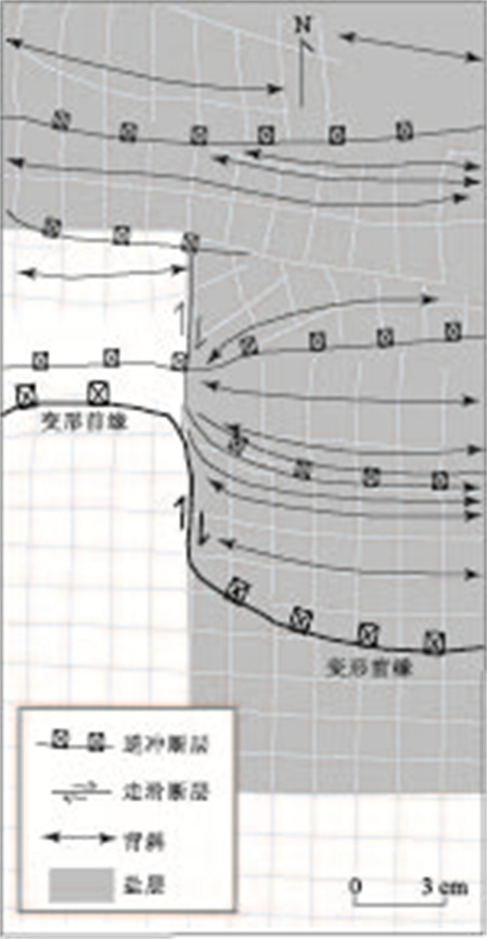
Kalayuergun structural belt (KSB) is the deformation leading edge of Kuqa fold and thrust belt, southern Tianshan, whose subsurface deformation characteristics is still unclear. Based on field observations, digital elevation model, well data and high-quality 2D seismic reflection profiles, we explore the distribution, geometry, kinematics and deformation age of anticlines in the KSB. Combined with the results of previous studies, the deformation controlling factors of the KSB are discussed. KSB extending E-W for about 165km, is a typical compressional structural belt, which is characterized by five elongate anticlines, including Beika, Zhongka, Nanka, Yangtage and Yingmaili anticlines, as well as several blind thrust faults developed at the core of anticlines. Cenozoic deformation characteristics of the KSB are summarized as the following five aspects: (1) Beika anticline is a salt pillow structure; (2) Asymmetric Zhongka and Nanka anticlines have opposite structural vergence, while a displacement transfer zone was formed between them; (3) Yangtage and Yingmaili anticlines are symmetric, low-amplitude detachment folds; (4) The amplitude of anticlines decrease gradually from west to east; (5) The deformation ages were youngling eastward progressively. The results of this study reveal that the major controlling factors of Cenozoic deformation in the KSB are regional compression, salt layer and basement structures.
Kalayuergun structural belt (KSB) is the deformation leading edge of Kuqa fold and thrust belt, southern Tianshan, whose subsurface deformation characteristics is still unclear. Based on field observations, digital elevation model, well data and high-quality 2D seismic reflection profiles, we explore the distribution, geometry, kinematics and deformation age of anticlines in the KSB. Combined with the results of previous studies, the deformation controlling factors of the KSB are discussed. KSB extending E-W for about 165km, is a typical compressional structural belt, which is characterized by five elongate anticlines, including Beika, Zhongka, Nanka, Yangtage and Yingmaili anticlines, as well as several blind thrust faults developed at the core of anticlines. Cenozoic deformation characteristics of the KSB are summarized as the following five aspects: (1) Beika anticline is a salt pillow structure; (2) Asymmetric Zhongka and Nanka anticlines have opposite structural vergence, while a displacement transfer zone was formed between them; (3) Yangtage and Yingmaili anticlines are symmetric, low-amplitude detachment folds; (4) The amplitude of anticlines decrease gradually from west to east; (5) The deformation ages were youngling eastward progressively. The results of this study reveal that the major controlling factors of Cenozoic deformation in the KSB are regional compression, salt layer and basement structures.


2013, 38(4): 870-876.
doi: 10.3799/dqkx.2013.085
Abstract:
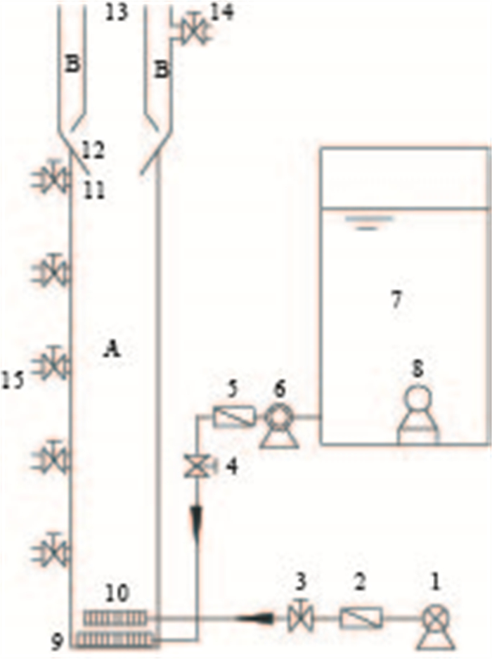
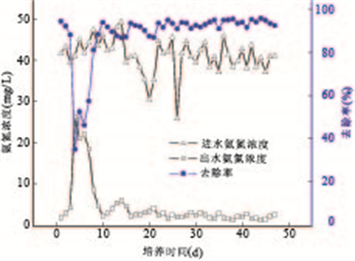
The successful cultivation of aerobic granular sludge with outstanding performance in airlift aerobic granular sludge bed reactor (AGSB) which was inoculated anaerobic granular sludge and aerobic flocculent sludge was performed using a synthetic wastewater mainly consisted of glucose as carbon source. The diameters of the granules ware 0.5-2.0mm and the sludge concentration in the reactor was in 5g/L or so. As the influent COD of 2000mg/L and the COD loading of 4.8kg/(m3·d) were employed, COD removal synthetic maintained more than 96%. Through the scanning electron microscopy observation, aerobic granular sludge was layered structure with a large number of filamentous bacteria winding on the surface, and some short bacillus and holes existing inside. After 47 days of cultivation, when the pharmaceutical wastewater completely replaced the synthetic water with gradually the increased pharmaceutical wastewater in the ratio of water, the COD, NH3-N, TP removal synthetic were more than 90%, 90%, and 70% respectively.
The successful cultivation of aerobic granular sludge with outstanding performance in airlift aerobic granular sludge bed reactor (AGSB) which was inoculated anaerobic granular sludge and aerobic flocculent sludge was performed using a synthetic wastewater mainly consisted of glucose as carbon source. The diameters of the granules ware 0.5-2.0mm and the sludge concentration in the reactor was in 5g/L or so. As the influent COD of 2000mg/L and the COD loading of 4.8kg/(m3·d) were employed, COD removal synthetic maintained more than 96%. Through the scanning electron microscopy observation, aerobic granular sludge was layered structure with a large number of filamentous bacteria winding on the surface, and some short bacillus and holes existing inside. After 47 days of cultivation, when the pharmaceutical wastewater completely replaced the synthetic water with gradually the increased pharmaceutical wastewater in the ratio of water, the COD, NH3-N, TP removal synthetic were more than 90%, 90%, and 70% respectively.


2013, 38(4): 877-886.
doi: 10.3799/dqkx.2013.086
Abstract:
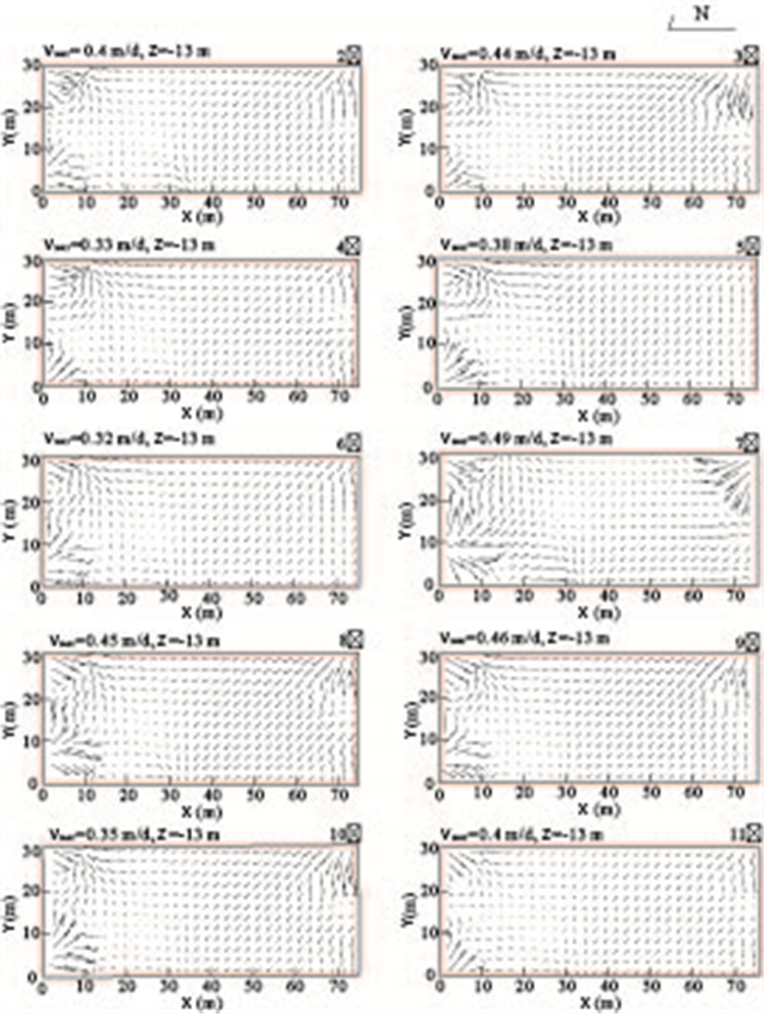
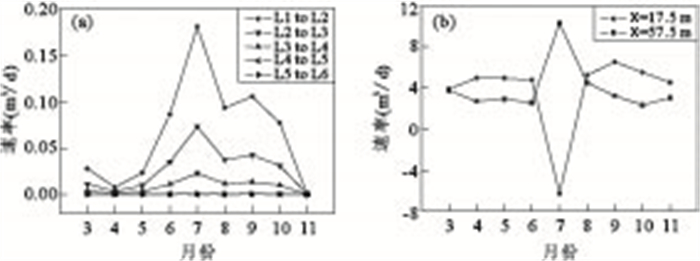
Groundwater flow patterns often play an important role in controlling groundwater hydrogeochemical characteristics. To better understanding of hydrological influences on arsenic transport in groundwater of Datong basin, a transient three dimensional groundwater flow model of riparian zone was conducted based on the monitoring data of Shanyin field site. The model indicates that irrigation diminishes the groundwater depth and horizontal groundwater flow velocities and further accelerates the groundwater flux among different formations. Vertical water exchanges occur frequently among silt layers (L1, L2, L3, L4), clay1 layer (L5) and sand1 layer (L6), while among clay2 layer (L7), sand2 layer (L8), clay3 layer (L9) and sand3 layer (L10), the horizontal groundwater exchanges dominates. The model also presents a possible phenomenon that the vertical infiltration of irrigation water and precipitation from ground surface toward aquifer induces a downward movement of arsenic of vadoze zone sediments, and frequent groundwater exchange greatly promotes the horizontal migration of arsenic in aquifers.
Groundwater flow patterns often play an important role in controlling groundwater hydrogeochemical characteristics. To better understanding of hydrological influences on arsenic transport in groundwater of Datong basin, a transient three dimensional groundwater flow model of riparian zone was conducted based on the monitoring data of Shanyin field site. The model indicates that irrigation diminishes the groundwater depth and horizontal groundwater flow velocities and further accelerates the groundwater flux among different formations. Vertical water exchanges occur frequently among silt layers (L1, L2, L3, L4), clay1 layer (L5) and sand1 layer (L6), while among clay2 layer (L7), sand2 layer (L8), clay3 layer (L9) and sand3 layer (L10), the horizontal groundwater exchanges dominates. The model also presents a possible phenomenon that the vertical infiltration of irrigation water and precipitation from ground surface toward aquifer induces a downward movement of arsenic of vadoze zone sediments, and frequent groundwater exchange greatly promotes the horizontal migration of arsenic in aquifers.


2013, 38(4): 887-897.
doi: 10.3799/dqkx.2013.087
Abstract:
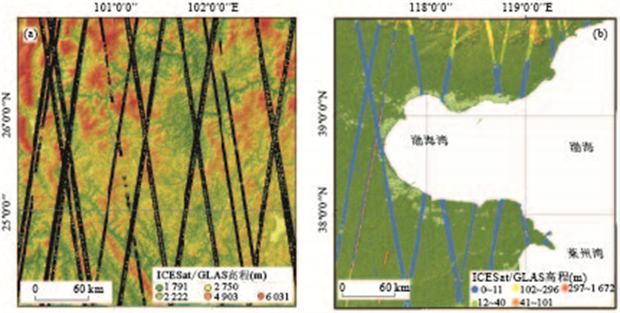
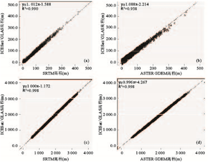
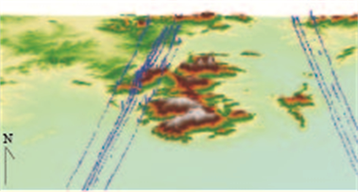
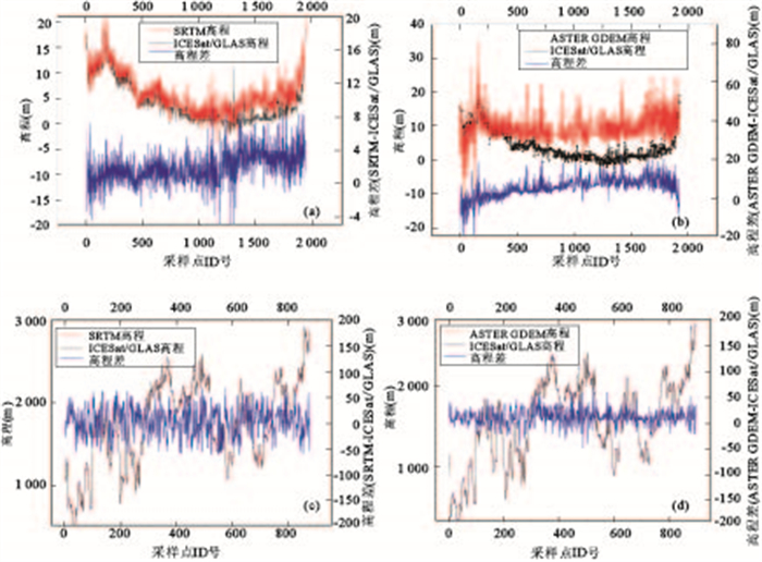
SRTM (shuttle radar topography mission) and ASTER GDEM (advanced spaceborne thermal emission and reflection radiometer global digital elevation model), the most accurate and available global DEM (digital elevation model) data, cover nearly the entire land surface of the earth. However, the precision of these DEM data has not been fully validated. This paper focuses on Chinese typical regions, aiming to verify the elevation precision of SRTM and ASTER GDEM based on ICESat / GLAS (ice, cloud, and land elevation satellite/geoscience laser altimeter system) elevation data by utilization of GIS (geographic information system) spatial analysis, 3D visualization and statistical analysis methods. The results show that SRTM elevation precision reaches 2.39m, and ASTER GDEM precision reaches 4.83m in the low altitude areas where the elevation value is less than 20m. The elevation precision is higher than the specified precision in both cases. However, the precision in Southwest study area is similar to the specified precision. The established linear regression model in the present study has high goodness of fit and significant correlation, but the applicability of the model needs further study.
SRTM (shuttle radar topography mission) and ASTER GDEM (advanced spaceborne thermal emission and reflection radiometer global digital elevation model), the most accurate and available global DEM (digital elevation model) data, cover nearly the entire land surface of the earth. However, the precision of these DEM data has not been fully validated. This paper focuses on Chinese typical regions, aiming to verify the elevation precision of SRTM and ASTER GDEM based on ICESat / GLAS (ice, cloud, and land elevation satellite/geoscience laser altimeter system) elevation data by utilization of GIS (geographic information system) spatial analysis, 3D visualization and statistical analysis methods. The results show that SRTM elevation precision reaches 2.39m, and ASTER GDEM precision reaches 4.83m in the low altitude areas where the elevation value is less than 20m. The elevation precision is higher than the specified precision in both cases. However, the precision in Southwest study area is similar to the specified precision. The established linear regression model in the present study has high goodness of fit and significant correlation, but the applicability of the model needs further study.


2013, 38(4): 898-906.
doi: 10.3799/dqkx.2013.088
Abstract:
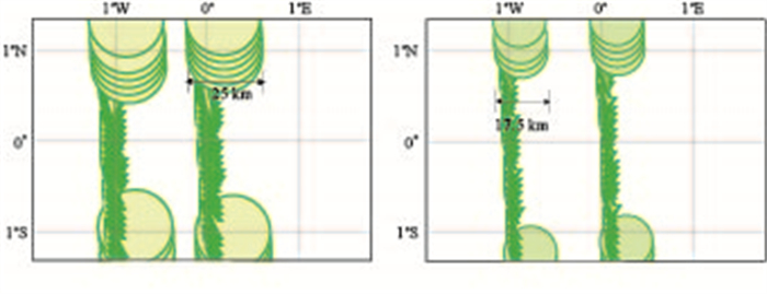
The design difference between Chang' E -1 microwave radiometer (CE-1 MRM) and Chang' E-2 microwave radiometer (CE-2 MRM) is presented in this paper, as well as the data processing algorithm and ground calibration coefficients of CE-2 MRM. Based on the data processing results, the distribution of brightness temperature (TB) of lunar surface is mapped. We propose a normalization model of TB by analyzing the regularity of the TB distribution and compare the result TB obtained by CE-2 MRM with CE-1 MRM. The discrepancy of TB for CE-2 MRM results from different nonlinear coefficients is presented at last. It is concluded that the CE-2 3GHz, 19.35GHz and 37GHz data coincide with earth-based observation, and the discrepancy between CE-1 and CE-2 MRM is smaller than 11K. There may be a systematic error on 7.8GHz channel.
The design difference between Chang' E -1 microwave radiometer (CE-1 MRM) and Chang' E-2 microwave radiometer (CE-2 MRM) is presented in this paper, as well as the data processing algorithm and ground calibration coefficients of CE-2 MRM. Based on the data processing results, the distribution of brightness temperature (TB) of lunar surface is mapped. We propose a normalization model of TB by analyzing the regularity of the TB distribution and compare the result TB obtained by CE-2 MRM with CE-1 MRM. The discrepancy of TB for CE-2 MRM results from different nonlinear coefficients is presented at last. It is concluded that the CE-2 3GHz, 19.35GHz and 37GHz data coincide with earth-based observation, and the discrepancy between CE-1 and CE-2 MRM is smaller than 11K. There may be a systematic error on 7.8GHz channel.