2013 Vol. 38, No. 5
Display Method:
 PDF 357KB
2013, 38(5): 907-915.
doi: 10.3799/dqkx.2013.089
Abstract:
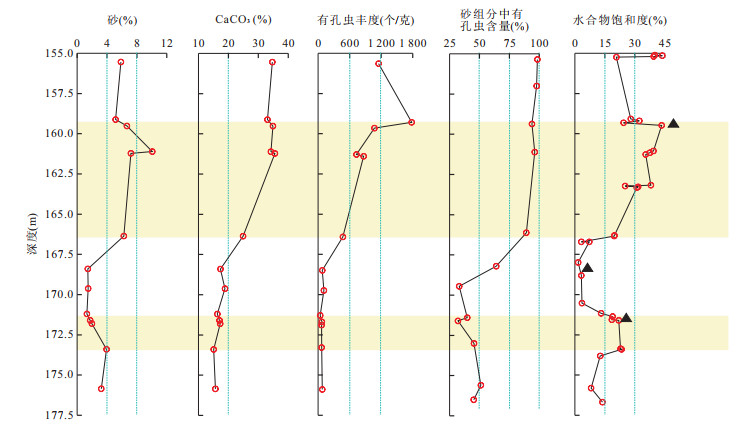
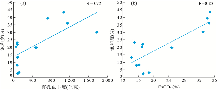
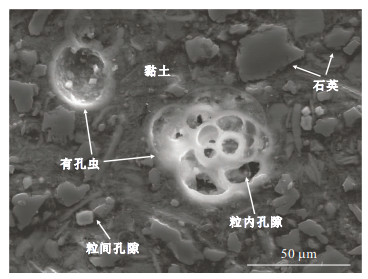
Based on studies of sedimentary features in the sediment interval containing high-saturation gas hydrate(HS-GHZ) in the Shenhu area, this paper presents results of Shenhu gas hydrates drilling site SH7B, at which HS-GHZ is observed at two major sediment intervals: between 155 and 166 m, and between 172 and 177 m. Our results suggest that the fine-grained sediments are foraminifera-contained clayey silt and silt; with very few siliceous microfossils. Two sediment intervals with high abundance of foraminifera coincide with two intervals of HS-GHZs, with high correlation coefficient up to 72%. Scanning electron microscope analysis on microstructure of sediments shows that existing of abundant sand-sized foramineral shells makes obvious contribution to the increase of sand fraction in these sediment intervals and shell-room space of foraminifers (intra-frame pore space) are significantly larger than pore space between silt-sized grains (inter-particle pore space). Only a few numbers of foraminiferal shell-rooms are filled with fine silt- or clay-sized grains or pyrites, suggesting slight influence of post-sedimentary diagenesis on foraminifera shells. In addition, shell-room spaces of foraminifers are generally in round-form with smooth pore-walls, which surely increases volume-containing capability in comparison with irregular and same diameter-sized inter-particle pore space. These evidences suggested that abundant foraminifers do not only increase in porosity of fine-grained sediments, but also provide high volume-containing capability of pore spaces for accumulating of gas hydrate in those two HS-GHZs at site SH7B. Furthermore, HS-GHZs are also well correlated to abundant foraminiferal intervals at two adjacent gas hydrates obtained sites, e.g.sites SH2B and SH3B, in the Shenhu area. All of these results lead to the assumption and explanation that a large portion of gas hydrates should be stored in shell-room spaces of abundant foraminifers in fine-grained sediment layers in Shenhu area, which are different from the results obtained by ODP gas hydrate drillings; and existence of abundant foraminifers is an important sedimentary factor for controlling accumulation and storage of high saturation of gas hydrates in Shenhu area.
Based on studies of sedimentary features in the sediment interval containing high-saturation gas hydrate(HS-GHZ) in the Shenhu area, this paper presents results of Shenhu gas hydrates drilling site SH7B, at which HS-GHZ is observed at two major sediment intervals: between 155 and 166 m, and between 172 and 177 m. Our results suggest that the fine-grained sediments are foraminifera-contained clayey silt and silt; with very few siliceous microfossils. Two sediment intervals with high abundance of foraminifera coincide with two intervals of HS-GHZs, with high correlation coefficient up to 72%. Scanning electron microscope analysis on microstructure of sediments shows that existing of abundant sand-sized foramineral shells makes obvious contribution to the increase of sand fraction in these sediment intervals and shell-room space of foraminifers (intra-frame pore space) are significantly larger than pore space between silt-sized grains (inter-particle pore space). Only a few numbers of foraminiferal shell-rooms are filled with fine silt- or clay-sized grains or pyrites, suggesting slight influence of post-sedimentary diagenesis on foraminifera shells. In addition, shell-room spaces of foraminifers are generally in round-form with smooth pore-walls, which surely increases volume-containing capability in comparison with irregular and same diameter-sized inter-particle pore space. These evidences suggested that abundant foraminifers do not only increase in porosity of fine-grained sediments, but also provide high volume-containing capability of pore spaces for accumulating of gas hydrate in those two HS-GHZs at site SH7B. Furthermore, HS-GHZs are also well correlated to abundant foraminiferal intervals at two adjacent gas hydrates obtained sites, e.g.sites SH2B and SH3B, in the Shenhu area. All of these results lead to the assumption and explanation that a large portion of gas hydrates should be stored in shell-room spaces of abundant foraminifers in fine-grained sediment layers in Shenhu area, which are different from the results obtained by ODP gas hydrate drillings; and existence of abundant foraminifers is an important sedimentary factor for controlling accumulation and storage of high saturation of gas hydrates in Shenhu area.


2013, 38(5): 916-922.
doi: 10.3799/dqkx.2013.090
Abstract:
In this paper, we present the major element compositions of the "Wushan loess", measured by X-ray fluorescence spectrometer. The content of major elements SiO2, Al2O3, TFe2O3, Fe2O3 and TiO2 varies with the content of clay in the profile. Besides the content of these elements displays several obvious circles and could be indicators of climate when the "Wushan loess" deposited. The elements of Si, Al, Fe, K, Mn and Ti show similarity and positive correlation during the weathering process while they are different from Ca and P, with negative correlation. The results reveal that grain size compositions of the sediments could dominate the content of some major elements. Major elements such as Al, Fe and Ti are concentrated in the clay fraction between 0.8 and 2.0 μm instead of the coarse silt and very fine sand fractions (40-100 μm). The UCC-normalized patterns of the "Wushan loess" are almost flat indicating the aeolian origin.
In this paper, we present the major element compositions of the "Wushan loess", measured by X-ray fluorescence spectrometer. The content of major elements SiO2, Al2O3, TFe2O3, Fe2O3 and TiO2 varies with the content of clay in the profile. Besides the content of these elements displays several obvious circles and could be indicators of climate when the "Wushan loess" deposited. The elements of Si, Al, Fe, K, Mn and Ti show similarity and positive correlation during the weathering process while they are different from Ca and P, with negative correlation. The results reveal that grain size compositions of the sediments could dominate the content of some major elements. Major elements such as Al, Fe and Ti are concentrated in the clay fraction between 0.8 and 2.0 μm instead of the coarse silt and very fine sand fractions (40-100 μm). The UCC-normalized patterns of the "Wushan loess" are almost flat indicating the aeolian origin.


2013, 38(5): 923-933.
doi: 10.3799/dqkx.2013.091
Abstract:
To determine provenance of sand-dust fallouts in Harbin area, Heilongjiang Province, the sand-dust fallouts in Harbin and two different grain size fractions (< 11 μm and 11-30 μm) of samples from the potential source areas, including Horqin sandy land and Songneng sandy land, are studied for rare earth element (REE) compositions. The results indicate that ΣREE for sand-dust fallouts in 2002 ranges from 179.07×10⁻⁶ to 200.92×10⁻⁶ with an average value of 189.67×10⁻⁶, ΣREE varied ranges from 166.70×10⁻⁶ to 184.44×10⁻⁶ with an average value of 175.57×10⁻⁶ for sand-dust fallouts in 2007, from 166.91×10⁻⁶ to 182.45×10⁻⁶ with an average value of 174.68×10⁻⁶ in 2008, ΣREE in 2011 is 181.35×10⁻⁶. The REE distribution for all sand-dust fallouts focuses on very narrow scopes, which displays provenance for sand-dust fallouts in Harbin is very stable. The dust falls show very similar REE distribution patterns and characteristic parameters with distinct negative Eu anomalies (δEu value for dust falls in 2002, 2007, 2008 varied from 0.71 to 0.75, δEu value in 2011 was 0.92) and slightly negative Ce anomalies (δCe value was in the range from 0.89 to 0.92 with an average of 0.90). The relatively large amount of evidence, such as REE values and distribution patterns and characteristic parameters and δEu vs. ΣREEs diagram and δEu vs. (LREE/HREE) diagram and (LREE/HREE) vs. LaN diagram, indicate that REE compositions for dust falls in Harbin are quite similar to those of Horqin sandy land (specially 11-30 μm grain size fractions), showing sand-dust in Harbin stems from Horqin sandy land but not Songneng sandy land, and showing material contribution of Horqin sandy land to dust falls in Harbin is mainly 11-30 μm grain-size fractions. It is confirmed that dust falls in Harbin are from Horqin sandy land by relevant meteorological records and meteorological data.
To determine provenance of sand-dust fallouts in Harbin area, Heilongjiang Province, the sand-dust fallouts in Harbin and two different grain size fractions (< 11 μm and 11-30 μm) of samples from the potential source areas, including Horqin sandy land and Songneng sandy land, are studied for rare earth element (REE) compositions. The results indicate that ΣREE for sand-dust fallouts in 2002 ranges from 179.07×10⁻⁶ to 200.92×10⁻⁶ with an average value of 189.67×10⁻⁶, ΣREE varied ranges from 166.70×10⁻⁶ to 184.44×10⁻⁶ with an average value of 175.57×10⁻⁶ for sand-dust fallouts in 2007, from 166.91×10⁻⁶ to 182.45×10⁻⁶ with an average value of 174.68×10⁻⁶ in 2008, ΣREE in 2011 is 181.35×10⁻⁶. The REE distribution for all sand-dust fallouts focuses on very narrow scopes, which displays provenance for sand-dust fallouts in Harbin is very stable. The dust falls show very similar REE distribution patterns and characteristic parameters with distinct negative Eu anomalies (δEu value for dust falls in 2002, 2007, 2008 varied from 0.71 to 0.75, δEu value in 2011 was 0.92) and slightly negative Ce anomalies (δCe value was in the range from 0.89 to 0.92 with an average of 0.90). The relatively large amount of evidence, such as REE values and distribution patterns and characteristic parameters and δEu vs. ΣREEs diagram and δEu vs. (LREE/HREE) diagram and (LREE/HREE) vs. LaN diagram, indicate that REE compositions for dust falls in Harbin are quite similar to those of Horqin sandy land (specially 11-30 μm grain size fractions), showing sand-dust in Harbin stems from Horqin sandy land but not Songneng sandy land, and showing material contribution of Horqin sandy land to dust falls in Harbin is mainly 11-30 μm grain-size fractions. It is confirmed that dust falls in Harbin are from Horqin sandy land by relevant meteorological records and meteorological data.


2013, 38(5): 934-946.
doi: 10.3799/dqkx.2013.092
Abstract:
The Upper Ordovician-Devonian strata are distributed asymmetrically in the North Qilian orogenic belt (NQOB) and are record of the collision process between Central Qilian block and North China plate. Age spectra of detrital zircons from the Upper Ordovician strata in the eastern of belt suggest that sediments in the basement of Upper Ordovician originate from the North Qilian arc and detritus in the upper part of Ordovician come from Central Qilian block and the North Qilian arc to the South and North China plate to the north. This change of source, integrated with ages of synsedimentary zircons, implies that the time of initial collision between Central Qilian block and North China plate is between 470 and 450 Ma. The Lower Silurian strata in the western part of belt preserve a large number of grains from Central Qilian block and North China plate, with the infill of sediments from the North Qilian arc and synorogenic granites, which imply the time of collision in the western part of belt. Compared to Ordovician lithofacies and the time of collision in the eastern and western parts, the asynchronous collision between Central Qilian block and North China plate suggest a "diachronous, unequal margin collision" model. This collisional model resulted in the Central Qilian block thrust onto the North Qilian arc and missed from sediments in the Lower Silurian in the eastern part of belt. Sediments form the North Qilian arc re-appeared in the Lower-Mid Devonian. Combined the distribution and deformation of Silurian and Devonian in the whole belt, the orogeny of NQOB is diachronous in the trending direction due to the "diachronous, unequal margin collision". The eastern sector had stronger tectonic intensity compared to the western sector, which resulted in the re-exposure of the North Qilian arc covered by Central Qilian block during the Early Silurian, infilling of synorogenic granites and recycle of the Mid-Upper Silurian. The Hexi-Corridor basin completed the transition from retroarc basin to remnant retroarc basin, to foreland basin during the Late Ordovician-Devonian.
The Upper Ordovician-Devonian strata are distributed asymmetrically in the North Qilian orogenic belt (NQOB) and are record of the collision process between Central Qilian block and North China plate. Age spectra of detrital zircons from the Upper Ordovician strata in the eastern of belt suggest that sediments in the basement of Upper Ordovician originate from the North Qilian arc and detritus in the upper part of Ordovician come from Central Qilian block and the North Qilian arc to the South and North China plate to the north. This change of source, integrated with ages of synsedimentary zircons, implies that the time of initial collision between Central Qilian block and North China plate is between 470 and 450 Ma. The Lower Silurian strata in the western part of belt preserve a large number of grains from Central Qilian block and North China plate, with the infill of sediments from the North Qilian arc and synorogenic granites, which imply the time of collision in the western part of belt. Compared to Ordovician lithofacies and the time of collision in the eastern and western parts, the asynchronous collision between Central Qilian block and North China plate suggest a "diachronous, unequal margin collision" model. This collisional model resulted in the Central Qilian block thrust onto the North Qilian arc and missed from sediments in the Lower Silurian in the eastern part of belt. Sediments form the North Qilian arc re-appeared in the Lower-Mid Devonian. Combined the distribution and deformation of Silurian and Devonian in the whole belt, the orogeny of NQOB is diachronous in the trending direction due to the "diachronous, unequal margin collision". The eastern sector had stronger tectonic intensity compared to the western sector, which resulted in the re-exposure of the North Qilian arc covered by Central Qilian block during the Early Silurian, infilling of synorogenic granites and recycle of the Mid-Upper Silurian. The Hexi-Corridor basin completed the transition from retroarc basin to remnant retroarc basin, to foreland basin during the Late Ordovician-Devonian.


2013, 38(5): 947-962.
doi: 10.3799/dqkx.2013.093
Abstract:
Middle Devonian Binggou granites from the eastern Kunlun orogen, are characterized by relatively high silicon (SiO2=71.85%-72.77%), total alkali (K2O+Na2O=8.39-8.58), aluminum(A/CNK=0.93-1.03), FeOt/MgO (6.24-7.86) and 104Ga/Al values (3.04-3.60), high LREE, obvious negative Eu anomalies, and notable enrichment of HFSE (Zr, Ga, Y, Hf, etc.), strong depletion of Ba, Sr, P and Ti relative to the primitive mantle, similar to the geochemical features of A-type granites. The LA-ICP-MS Zircon U-Pb analyses yield a weighted mean 206Pb/238U age of 391±3 Ma (MSWD=2.36), considered to be the formation age of the Binggou granites. With a comprehensive consideration on many different indexes, such as whole rock Sr-Nd isotopes, geochemistry, experimental petrology and so on, we conclude that the Binggou granites formed by partial melting of crust materials (meta-greywacke) on the conditions of low pressure and high temperature at the stage of postorogenic stretch. The Binggou granites are younger than the other Paleozoic A-type granites reported in the eastern Kunlun orogen, suggesting the ending proto-tethys and the beginning paleo-tethys.
Middle Devonian Binggou granites from the eastern Kunlun orogen, are characterized by relatively high silicon (SiO2=71.85%-72.77%), total alkali (K2O+Na2O=8.39-8.58), aluminum(A/CNK=0.93-1.03), FeOt/MgO (6.24-7.86) and 104Ga/Al values (3.04-3.60), high LREE, obvious negative Eu anomalies, and notable enrichment of HFSE (Zr, Ga, Y, Hf, etc.), strong depletion of Ba, Sr, P and Ti relative to the primitive mantle, similar to the geochemical features of A-type granites. The LA-ICP-MS Zircon U-Pb analyses yield a weighted mean 206Pb/238U age of 391±3 Ma (MSWD=2.36), considered to be the formation age of the Binggou granites. With a comprehensive consideration on many different indexes, such as whole rock Sr-Nd isotopes, geochemistry, experimental petrology and so on, we conclude that the Binggou granites formed by partial melting of crust materials (meta-greywacke) on the conditions of low pressure and high temperature at the stage of postorogenic stretch. The Binggou granites are younger than the other Paleozoic A-type granites reported in the eastern Kunlun orogen, suggesting the ending proto-tethys and the beginning paleo-tethys.


2013, 38(5): 963-974.
doi: 10.3799/dqkx.2013.094
Abstract:
Carboniferous volcanic rocks are widely distributed in northern Alashan League and its neighboring areas, and their genesis and tectonic setting have always been an issue of controversy. Based on analysis of petrology and petrogeochemistry characteristics of Carboniferous volcanic rocks in the study area, this paper attempts to clarify the palaeo-tectonic setting and provides independent evidence for understanding the properties of Carboniferous basin. The volcanic rocks are dominated by intermediate-acidic volcanic rock. The majority of basalts, basaltic-andesite and andesite fall into sub-alkaline series. Mg# number of this suit ranges from 0.29 to 0.69. These volcanic rocks samples exhibit strong depletion in the high field strength elements Nb, Ta and Ti, and minor enrichment in the LREE. In terms of REE, (La/Yb)N number ranges from 2.19 to 10.10, showing less obvious Eu depletion (δEu=0.81 to 1.08), and slightly right-inclined REE distribution patterns, with higher εNd(t) value (+1.10 to +6.35). The samples show not only the marks of those within plate setting as a whole, but also those of subduction zone. Combining with the regional geological characteristic, we conclude that the Carboniferous magmatic activity in the study area generated in a within-plate setting, with variable degrees of contamination of crust during magma ascending, and probably related to mantle plume event.
Carboniferous volcanic rocks are widely distributed in northern Alashan League and its neighboring areas, and their genesis and tectonic setting have always been an issue of controversy. Based on analysis of petrology and petrogeochemistry characteristics of Carboniferous volcanic rocks in the study area, this paper attempts to clarify the palaeo-tectonic setting and provides independent evidence for understanding the properties of Carboniferous basin. The volcanic rocks are dominated by intermediate-acidic volcanic rock. The majority of basalts, basaltic-andesite and andesite fall into sub-alkaline series. Mg# number of this suit ranges from 0.29 to 0.69. These volcanic rocks samples exhibit strong depletion in the high field strength elements Nb, Ta and Ti, and minor enrichment in the LREE. In terms of REE, (La/Yb)N number ranges from 2.19 to 10.10, showing less obvious Eu depletion (δEu=0.81 to 1.08), and slightly right-inclined REE distribution patterns, with higher εNd(t) value (+1.10 to +6.35). The samples show not only the marks of those within plate setting as a whole, but also those of subduction zone. Combining with the regional geological characteristic, we conclude that the Carboniferous magmatic activity in the study area generated in a within-plate setting, with variable degrees of contamination of crust during magma ascending, and probably related to mantle plume event.


2013, 38(5): 975-982.
doi: 10.3799/dqkx.2013.095
Abstract:
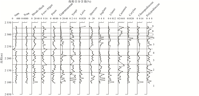
Many samplings, tests and analysis are carried out to study the lacustrine sediments which are more than 200 m thick inside the Diexi ancient dammed lake on Minjing river. The pollen and spore of the sediments and sedimentation time are tested by which the ancient dammed lake sedimentation time and climate-environment characteristics are obtained. It is found that bottom parts of the ancient dammed lake lacustrine sediments were formed 30 000 years ago, while the parts close to the top formed 15 000 years ago. The pollen and spore test results indicate that the sediment section of the ancient dammed lake can be classified into the following 9 climate-environment sections: (1) Cool and semi-moist, needle leave and broad leave mixed forest and grassland climate-environment; (2) cold and dry, needle leave forest and grass land climate-environment; (3) cool and semi-moist, needle leave and broad leave mixed open forest and grassland climate-environment; (4) warm and humid, needle leave and broad leave mixed forest grassland climate-environment; (5) cool and semi-dry, needle leave and broad leave mixed open forest and grassland climate-environment; (6) cool and semi-moist forest and grassland climate-environment; (7) cold and dry, open forest and grassland climate-environment. The evolution characteristics of the Palaeo-climate and Palaeo-environment of the transition area of east edge of Qinghai-Tibetan Plateau to Sichuan basin during time period between 30 000 to 15 000 years ago is described, which can provide information for the regional environment study.
Many samplings, tests and analysis are carried out to study the lacustrine sediments which are more than 200 m thick inside the Diexi ancient dammed lake on Minjing river. The pollen and spore of the sediments and sedimentation time are tested by which the ancient dammed lake sedimentation time and climate-environment characteristics are obtained. It is found that bottom parts of the ancient dammed lake lacustrine sediments were formed 30 000 years ago, while the parts close to the top formed 15 000 years ago. The pollen and spore test results indicate that the sediment section of the ancient dammed lake can be classified into the following 9 climate-environment sections: (1) Cool and semi-moist, needle leave and broad leave mixed forest and grassland climate-environment; (2) cold and dry, needle leave forest and grass land climate-environment; (3) cool and semi-moist, needle leave and broad leave mixed open forest and grassland climate-environment; (4) warm and humid, needle leave and broad leave mixed forest grassland climate-environment; (5) cool and semi-dry, needle leave and broad leave mixed open forest and grassland climate-environment; (6) cool and semi-moist forest and grassland climate-environment; (7) cold and dry, open forest and grassland climate-environment. The evolution characteristics of the Palaeo-climate and Palaeo-environment of the transition area of east edge of Qinghai-Tibetan Plateau to Sichuan basin during time period between 30 000 to 15 000 years ago is described, which can provide information for the regional environment study.


2013, 38(5): 983-994.
doi: 10.3799/dqkx.2013.096
Abstract:
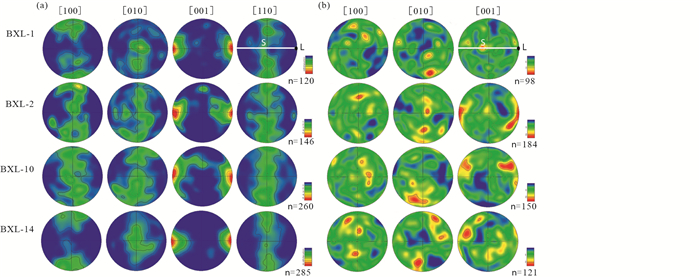
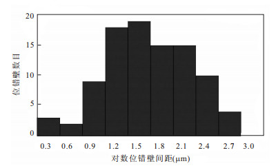
Studies of deformed microstructures of peridotite in ultrahigh-pressure metamorphic belt are conductive to understand rheological property and deformation mechanism of mantle materials derived from plate boundary, then further to explore the effect of microstructures during geodynamic process of the deep subduction and exhumation. Deformed microstructures of garnet wehrlite from Bixiling, Dabie Mountains are systematically studied through optical microscope, electron probe, infrared spectroscopy, electron back scattered diffraction (EBSD) technique and the method of oxidation decoration. Results show that: (1) garnet wehrlite from Bixiling with strong shape preferred orientation (SPO), but only clinopyroxene with strong lattice preferred orientation (LPO) and olivine with weak lattice preferred orientation, which is obviously different from the common characteristics of mantle peridotite which exhibits the stronger fabric in olivine than in clinopyroxene and in addition, reflects that clinopyroxene deforms through dislocation creep but olivine through grain boundary sliding with the adjustment of dislocation; (2) certain content of structural water are contained in clinopyroxene and olivine of garnet wehrlite from Bixiling, clinopyroxene with 124×10-6-247×10-6 and olivine with 38×10-6-80×10-6, which are higher than that in minerals of general peridotite in orogenic belt and may reflect the environment with high water content caused by the contamination of crust material; (3) significant dislocation microstructures developed in olivine and 230-600 MPa of differential stress calculated by the dislocation microstructures which is higher than the steady flow stress of normal upper mantle and indicates that our samples once have experienced the relative low-temperature deforming environment in subduction zone. Comprehensive study shows that the relatively special deforming microstructures in olivine and clinopyroxene from Bixiling attribute to the high pressure, low temperature, high differential stress and structural water content in ultrahigh-pressure metamorphic belt.
Studies of deformed microstructures of peridotite in ultrahigh-pressure metamorphic belt are conductive to understand rheological property and deformation mechanism of mantle materials derived from plate boundary, then further to explore the effect of microstructures during geodynamic process of the deep subduction and exhumation. Deformed microstructures of garnet wehrlite from Bixiling, Dabie Mountains are systematically studied through optical microscope, electron probe, infrared spectroscopy, electron back scattered diffraction (EBSD) technique and the method of oxidation decoration. Results show that: (1) garnet wehrlite from Bixiling with strong shape preferred orientation (SPO), but only clinopyroxene with strong lattice preferred orientation (LPO) and olivine with weak lattice preferred orientation, which is obviously different from the common characteristics of mantle peridotite which exhibits the stronger fabric in olivine than in clinopyroxene and in addition, reflects that clinopyroxene deforms through dislocation creep but olivine through grain boundary sliding with the adjustment of dislocation; (2) certain content of structural water are contained in clinopyroxene and olivine of garnet wehrlite from Bixiling, clinopyroxene with 124×10-6-247×10-6 and olivine with 38×10-6-80×10-6, which are higher than that in minerals of general peridotite in orogenic belt and may reflect the environment with high water content caused by the contamination of crust material; (3) significant dislocation microstructures developed in olivine and 230-600 MPa of differential stress calculated by the dislocation microstructures which is higher than the steady flow stress of normal upper mantle and indicates that our samples once have experienced the relative low-temperature deforming environment in subduction zone. Comprehensive study shows that the relatively special deforming microstructures in olivine and clinopyroxene from Bixiling attribute to the high pressure, low temperature, high differential stress and structural water content in ultrahigh-pressure metamorphic belt.


2013, 38(5): 995-1004.
doi: 10.3799/dqkx.2013.097
Abstract:
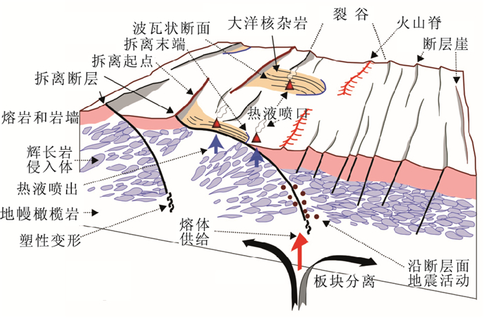
A new type of seafloor spreading mode has recently been well acknowledged among earth science community. It is different from normal magmatic spreading ridge. It is usually found along the slow or ultraslow spreading ridge where the segment is amagmatic or depleted in magma. The plate separation is mostly accommodated by detachment fault slipping. The low-angle large-offset detachment fault will uplift the footwall and exhume lower crust and upper mantle rocks, which is called oceanic core complex. The oceanic core complex, also named as megamullion, is often marked by corrugations and striations parallel to the extension direction. This paper presents the characteristics of this new kind of spreading mode based on in-depth argument about terminology of detachment fault and oceanic core complex. A distribution map of the known oceanic core complex has been composed. The possible methods and techniques that can be used to recognize oceanic core complexes are also discussed in this study, and so does the significance of the new findings and its influence on seafloor hydrothermal activity and mineral deposit.
A new type of seafloor spreading mode has recently been well acknowledged among earth science community. It is different from normal magmatic spreading ridge. It is usually found along the slow or ultraslow spreading ridge where the segment is amagmatic or depleted in magma. The plate separation is mostly accommodated by detachment fault slipping. The low-angle large-offset detachment fault will uplift the footwall and exhume lower crust and upper mantle rocks, which is called oceanic core complex. The oceanic core complex, also named as megamullion, is often marked by corrugations and striations parallel to the extension direction. This paper presents the characteristics of this new kind of spreading mode based on in-depth argument about terminology of detachment fault and oceanic core complex. A distribution map of the known oceanic core complex has been composed. The possible methods and techniques that can be used to recognize oceanic core complexes are also discussed in this study, and so does the significance of the new findings and its influence on seafloor hydrothermal activity and mineral deposit.


2013, 38(5): 1005-1013.
doi: 10.3799/dqkx.2013.098
Abstract:
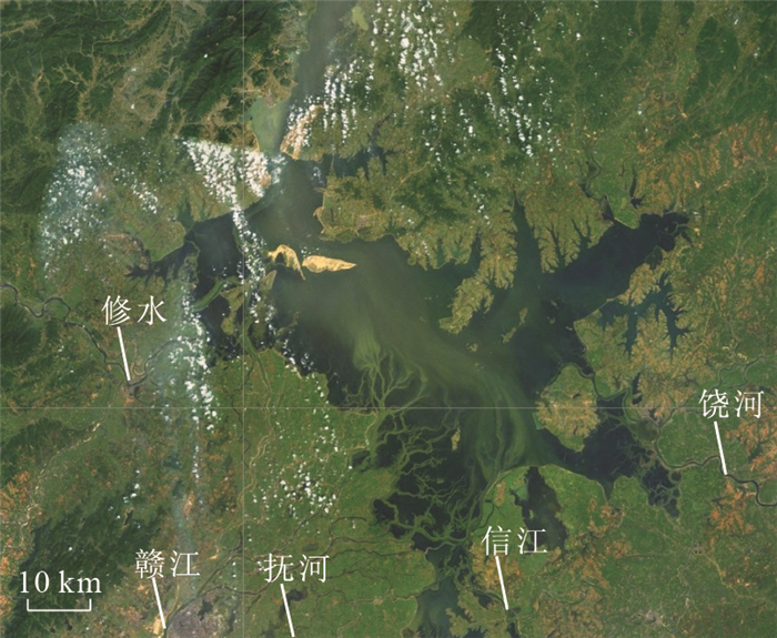
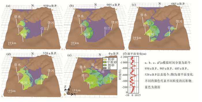
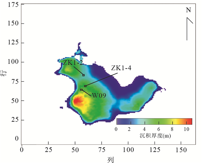
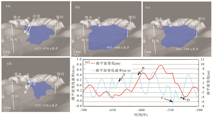
Large-scale shallow-water deltas in lacustrine basins have recently been identified as important reservoir plains in the world. The Poyang Lake, the largest fresh water lake of China, develops a series of modern shallow-water deltas, hence provides a good modern analogue for understanding various key depositional processes that control deltaic development and evolution. This paper uses Sedsim, a three-dimensional stratigraphic forward modelling program, to simulate the development and evolution of the shallow-water deltas in the Poyang Lake by considering a number of key processes and parameters affecting the deltaic deposition over 1200 years. According to our simulation results, the construction of the shallow-water deltas in the Poyang Lake is primarily controlled by the lake level fluctuations, the discharge rate of sediment, and the pre-existing topography/bathymetry. It shows that the sand bodies in the delta front are basically sand sheets, which are mainly distributed near the lake open circulation area due to the shallow water depth of the lake, the gentle slope of the depositional basement and the high frequency of lake-level fluctuations. In addition, the frequency of relative lake level oscillation appears to be a significant controlling factor on the development and divarication of river channels on the upper delta plain. A lower rate of the lake level rise and a faster rate of the lake level fall would cause enhanced river channel development and divarication. This study not only enables us to quantitatively understand the dynamic processes of shallow-water delta systems and the key factors controlling the deltaic development and evolution but also provides a reference model for similar ancient depositional systems in sedimentary basins, where active hydrocarbon exploration is currently being undertaken.
Large-scale shallow-water deltas in lacustrine basins have recently been identified as important reservoir plains in the world. The Poyang Lake, the largest fresh water lake of China, develops a series of modern shallow-water deltas, hence provides a good modern analogue for understanding various key depositional processes that control deltaic development and evolution. This paper uses Sedsim, a three-dimensional stratigraphic forward modelling program, to simulate the development and evolution of the shallow-water deltas in the Poyang Lake by considering a number of key processes and parameters affecting the deltaic deposition over 1200 years. According to our simulation results, the construction of the shallow-water deltas in the Poyang Lake is primarily controlled by the lake level fluctuations, the discharge rate of sediment, and the pre-existing topography/bathymetry. It shows that the sand bodies in the delta front are basically sand sheets, which are mainly distributed near the lake open circulation area due to the shallow water depth of the lake, the gentle slope of the depositional basement and the high frequency of lake-level fluctuations. In addition, the frequency of relative lake level oscillation appears to be a significant controlling factor on the development and divarication of river channels on the upper delta plain. A lower rate of the lake level rise and a faster rate of the lake level fall would cause enhanced river channel development and divarication. This study not only enables us to quantitatively understand the dynamic processes of shallow-water delta systems and the key factors controlling the deltaic development and evolution but also provides a reference model for similar ancient depositional systems in sedimentary basins, where active hydrocarbon exploration is currently being undertaken.


2013, 38(5): 1014-1022.
doi: 10.3799/dqkx.2013.099
Abstract:
The lipid biomarkers of hopanoid acids in cold seep carbonates from the South China Sea continental slope are investigated. In the hopanoid acids, 17β(H), 21β(H)-30-hopanoid acid-17β(H), 21β(H)-33-hopanoid acid are identified with 17β(H), 21β(H)-32-hopanoid acid being the most aboundant. The 17β(H), 21β(H)-32-hopanoic acid depleted in 13C and the δ13C value(-69.8‰) fall close to the range of SRB (sulfate-reducing bacteria)-derived iso-/anteiso-C15:0 (-75.2‰ to -90.0‰) in site1 seep carbonate(TVG3-C2, ANME-2 dominated), suggesting the incorporation of methane-derived carbon. Although they show non-seep isotopic signatures (-30.7‰ to -40.3‰, ANME-1 dominated) in site3 (TVG8-C5) and site2 seep carbonates (TVG13-C3 and TVG14-C2), hopanoids δ13C values fall close to the range of SRB-derived iso-/anteiso-C15:0 (-32.5‰ to -49.8‰). The majority of SRB are not involved in AOM (anaerobic oxidization of methane) possibly because ANME-1 cells often occur as monospecific aggregates.
The lipid biomarkers of hopanoid acids in cold seep carbonates from the South China Sea continental slope are investigated. In the hopanoid acids, 17β(H), 21β(H)-30-hopanoid acid-17β(H), 21β(H)-33-hopanoid acid are identified with 17β(H), 21β(H)-32-hopanoid acid being the most aboundant. The 17β(H), 21β(H)-32-hopanoic acid depleted in 13C and the δ13C value(-69.8‰) fall close to the range of SRB (sulfate-reducing bacteria)-derived iso-/anteiso-C15:0 (-75.2‰ to -90.0‰) in site1 seep carbonate(TVG3-C2, ANME-2 dominated), suggesting the incorporation of methane-derived carbon. Although they show non-seep isotopic signatures (-30.7‰ to -40.3‰, ANME-1 dominated) in site3 (TVG8-C5) and site2 seep carbonates (TVG13-C3 and TVG14-C2), hopanoids δ13C values fall close to the range of SRB-derived iso-/anteiso-C15:0 (-32.5‰ to -49.8‰). The majority of SRB are not involved in AOM (anaerobic oxidization of methane) possibly because ANME-1 cells often occur as monospecific aggregates.


2013, 38(5): 1023-1036.
doi: 10.3799/dqkx.2013.100
Abstract:
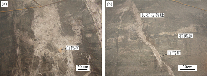
The Laojunshan ore concentration area, containing many tungsten deposits of Nanyangtian, Huashitou and Chayeshan, is one of the few tungsten concentration areas in the western Nanling metallogenic belt. But, its regional ore-forming ages are controversial due to multi-stage tectono-thermal events. In this paper, the scheelite Sm-Nd dating method was used to determine the ore-forming age of the feldspar quartz vein type ore bodies in the Nanyangtian ore field, and the muscovite and biotite Ar-Ar dating method were used to determine the crystallization ages of the regional granitic pegmatites and the metamorphic age of their wall rocks respectively. The dating results show that the feldspar quartz veins type ore bodies formed at 159±14 Ma, younger than the skarn type ore bodies, and the pegmatite crystallization ages and the wall rock's metamorphic ages are 144-141 Ma and 121-112 Ma respectively. So the Late Jurassic-Early Cretaceous tectono-thermal event and tungsten mineralization occurred in Laojunshan area. The metallogenic regularity in the Laojunshan areas illustrates that the regional ore deposits or spots are constrained by the regional granite gneiss and granitic intrusion, and the ore-forming period is consistent with the three ore-forming peaks in the Nanling minerallenic belt. Furthermore, the mineralization features in Laojunshan area are similar with that in the eastern Nanling metallogenic belt, which may be due to the high denudation degree. It is concluded that the great denudation area in the western Nanling region has great potential to find tungsten deposit formed in Late Triassic and Indo-Chinese and Late Jurassic-Early Cretaceous.
The Laojunshan ore concentration area, containing many tungsten deposits of Nanyangtian, Huashitou and Chayeshan, is one of the few tungsten concentration areas in the western Nanling metallogenic belt. But, its regional ore-forming ages are controversial due to multi-stage tectono-thermal events. In this paper, the scheelite Sm-Nd dating method was used to determine the ore-forming age of the feldspar quartz vein type ore bodies in the Nanyangtian ore field, and the muscovite and biotite Ar-Ar dating method were used to determine the crystallization ages of the regional granitic pegmatites and the metamorphic age of their wall rocks respectively. The dating results show that the feldspar quartz veins type ore bodies formed at 159±14 Ma, younger than the skarn type ore bodies, and the pegmatite crystallization ages and the wall rock's metamorphic ages are 144-141 Ma and 121-112 Ma respectively. So the Late Jurassic-Early Cretaceous tectono-thermal event and tungsten mineralization occurred in Laojunshan area. The metallogenic regularity in the Laojunshan areas illustrates that the regional ore deposits or spots are constrained by the regional granite gneiss and granitic intrusion, and the ore-forming period is consistent with the three ore-forming peaks in the Nanling minerallenic belt. Furthermore, the mineralization features in Laojunshan area are similar with that in the eastern Nanling metallogenic belt, which may be due to the high denudation degree. It is concluded that the great denudation area in the western Nanling region has great potential to find tungsten deposit formed in Late Triassic and Indo-Chinese and Late Jurassic-Early Cretaceous.


2013, 38(5): 1037-1046.
doi: 10.3799/dqkx.2013.101
Abstract:
Based on the statistic study of 324 groups of published coal type gas geochemical data from 21 basins or areas from all over the world, stratigraphic distribution, stable carbon and hydrogen isotopic composition, and spatial distribution of coal type gas in various genesis are analyzed. Multiple charts for identifying the genetic types of coal type gas are established. And the feasibility of these charts is demonstrated by an example. The results show that biogenic gases that generated from coal seam are not the same as normal biogas (compared with normal gas). The most significant difference is the δ13C(CH4) value of microbial gases lower than that of normal biogas. The stable isotopic composition of microbial gases fall within the following ranges: δ13C(CH4) < -60‰, while for thermogenic gases, δ13C(CH4) > -40‰. And for mixed gases, δ13C(CH4) ranges from -60‰ to -40‰. There is a tendency that from biogenic gases to thermogenic gases, δ13C(CH4), δ13C(CO2-CH4), δ13C(C2H6-CH4), and CH4/(C2H6+C3H8) gradually become heavier with the increase of the maturity of organic matter. An obvious positive correlation exists among aforementioned parameters. It is concluded that the charts of δ13C(CH4) and δ13C(CO2-CH4), δ13C(CH4) and δ13C(C2H6-CH4), and δ13C(CH4) and CH4/(C2H6+C3H8) are the most reliable charts for classifying the genetic type of coal type gas.
Based on the statistic study of 324 groups of published coal type gas geochemical data from 21 basins or areas from all over the world, stratigraphic distribution, stable carbon and hydrogen isotopic composition, and spatial distribution of coal type gas in various genesis are analyzed. Multiple charts for identifying the genetic types of coal type gas are established. And the feasibility of these charts is demonstrated by an example. The results show that biogenic gases that generated from coal seam are not the same as normal biogas (compared with normal gas). The most significant difference is the δ13C(CH4) value of microbial gases lower than that of normal biogas. The stable isotopic composition of microbial gases fall within the following ranges: δ13C(CH4) < -60‰, while for thermogenic gases, δ13C(CH4) > -40‰. And for mixed gases, δ13C(CH4) ranges from -60‰ to -40‰. There is a tendency that from biogenic gases to thermogenic gases, δ13C(CH4), δ13C(CO2-CH4), δ13C(C2H6-CH4), and CH4/(C2H6+C3H8) gradually become heavier with the increase of the maturity of organic matter. An obvious positive correlation exists among aforementioned parameters. It is concluded that the charts of δ13C(CH4) and δ13C(CO2-CH4), δ13C(CH4) and δ13C(C2H6-CH4), and δ13C(CH4) and CH4/(C2H6+C3H8) are the most reliable charts for classifying the genetic type of coal type gas.


2013, 38(5): 1047-1052.
doi: 10.3799/dqkx.2013.102
Abstract:
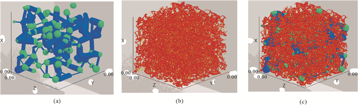
Due to bimodal pore size distribution of carbonate rocks, macro pore network and micro pore network are produced to describe different pore characteristics separately, and carbonate dual pore network is constructed with the coupling of macro pore and micro pore network. Then primary drainage and secondary imbibition process are simulated based on intrusion-percolation theory during the oil-water two phase fluid flow, the capillary pressure and relative permeability model are calculated. At last, the influence of reservoir parameters on relative permeability curve is studied under water-wet conditions by adjusting the network structure parameters. Results show that oil relative permeability curve rises with the increase of micro pore density factor and average coordination number, and oil and water relative permeability curve drops with the increase of dual pore radius ratio. These phenomena are important to the study of carbonate reservoir microscopic flow mechanism.
Due to bimodal pore size distribution of carbonate rocks, macro pore network and micro pore network are produced to describe different pore characteristics separately, and carbonate dual pore network is constructed with the coupling of macro pore and micro pore network. Then primary drainage and secondary imbibition process are simulated based on intrusion-percolation theory during the oil-water two phase fluid flow, the capillary pressure and relative permeability model are calculated. At last, the influence of reservoir parameters on relative permeability curve is studied under water-wet conditions by adjusting the network structure parameters. Results show that oil relative permeability curve rises with the increase of micro pore density factor and average coordination number, and oil and water relative permeability curve drops with the increase of dual pore radius ratio. These phenomena are important to the study of carbonate reservoir microscopic flow mechanism.


2013, 38(5): 1053-1064.
doi: 10.3799/dqkx.2013.103
Abstract:
As the second oil and gas pioneering project progresses, marine strata has become the focus in the field of oil and gas exploration. Lower Yangtze has deposited thick marine strata, and its prototype basin has experienced structural transformation of multi-period times. This paper discusses the boundary under the Yangtze, aiming to conduct a systematic analysis of the entire system. Based on the "TSM" strategy of basin prototype analysis on the basin tectonics, deformation and sedimentary, the residual strata distribution from Late Sinian to Middle Ordovician in the Lower Yangtze and the sedimentary filling during the process are analyzed. The results indicate that the Lower Yangtze has evolved passive continental margin in the Late Sinian-Middle Ordovician, which is characterized mainly by siliceous classic sediments, carbonate sediment and synsedimentary faults, etc.. During this period, carbonate platform developed into trim platform. The platform had lateral growth phenomenon and the sediment of tongue protruding input to the sea basin. Jiangnan fault, a typical synsedimentary fault, shows that the source material of the sediment basin has always been transported from northwest to southeast by the internal one-way transportation in the Lower Yangtze. All these indicate that it was mature passive continental from the Late Sinian to Middle Ordovician.
As the second oil and gas pioneering project progresses, marine strata has become the focus in the field of oil and gas exploration. Lower Yangtze has deposited thick marine strata, and its prototype basin has experienced structural transformation of multi-period times. This paper discusses the boundary under the Yangtze, aiming to conduct a systematic analysis of the entire system. Based on the "TSM" strategy of basin prototype analysis on the basin tectonics, deformation and sedimentary, the residual strata distribution from Late Sinian to Middle Ordovician in the Lower Yangtze and the sedimentary filling during the process are analyzed. The results indicate that the Lower Yangtze has evolved passive continental margin in the Late Sinian-Middle Ordovician, which is characterized mainly by siliceous classic sediments, carbonate sediment and synsedimentary faults, etc.. During this period, carbonate platform developed into trim platform. The platform had lateral growth phenomenon and the sediment of tongue protruding input to the sea basin. Jiangnan fault, a typical synsedimentary fault, shows that the source material of the sediment basin has always been transported from northwest to southeast by the internal one-way transportation in the Lower Yangtze. All these indicate that it was mature passive continental from the Late Sinian to Middle Ordovician.


2013, 38(5): 1065-1072.
doi: 10.3799/dqkx.2013.104
Abstract:
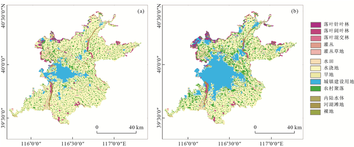
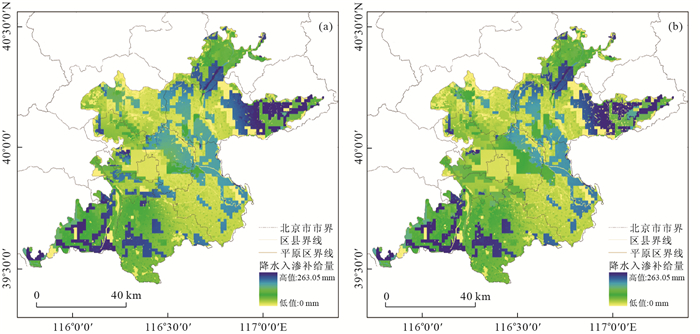
The WetSpass model is used to analyze the impact of urbanization on precipitation infiltration recharge in Beijing Plain combined with the technology of GIS (geographic information system) and RS (remote sense) in this paper. Based on the simulated precipitation infiltration in 1982 and 2007, the influence of land use changing on the precipitation infiltration is quantitatively analyzed by assuming the land-use type in 2007 was the same as that in 1982, and re-running WetSpass model with other input data in 2007. The transfer matrix is used to analyze the mutual transformation relationship of land-use types in the above-mentioned two years, and the statistical function of GIS is used to calculate the groundwater recharge under different land-use types. Results show that the area of irrigable land decreased by 874 km2 from 1982 to 2007, among which 517 km2 turned to the central urban land. The central urban area increased by about 831 km2. The increasing urban area and the decreasing crop area eventually lead to the reduction of the average groundwater recharge. The groundwater recharge decreased by about 3×10⁷ m3 in 2007 compared with the value under the simulated condition. The precipitation infiltration changed obviously in the region around Chaoyang and Fengtai districts characterized by significant urban expansion. This study can be a scientific reference for the groundwater resources protection and city layout of Beijing Plain.
The WetSpass model is used to analyze the impact of urbanization on precipitation infiltration recharge in Beijing Plain combined with the technology of GIS (geographic information system) and RS (remote sense) in this paper. Based on the simulated precipitation infiltration in 1982 and 2007, the influence of land use changing on the precipitation infiltration is quantitatively analyzed by assuming the land-use type in 2007 was the same as that in 1982, and re-running WetSpass model with other input data in 2007. The transfer matrix is used to analyze the mutual transformation relationship of land-use types in the above-mentioned two years, and the statistical function of GIS is used to calculate the groundwater recharge under different land-use types. Results show that the area of irrigable land decreased by 874 km2 from 1982 to 2007, among which 517 km2 turned to the central urban land. The central urban area increased by about 831 km2. The increasing urban area and the decreasing crop area eventually lead to the reduction of the average groundwater recharge. The groundwater recharge decreased by about 3×10⁷ m3 in 2007 compared with the value under the simulated condition. The precipitation infiltration changed obviously in the region around Chaoyang and Fengtai districts characterized by significant urban expansion. This study can be a scientific reference for the groundwater resources protection and city layout of Beijing Plain.


2013, 38(5): 1073-1080, 1090.
doi: 10.3799/dqkx.2013.105
Abstract:
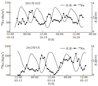
The aim of this paper is to quantify submarine groundwater discharge (SGD) into the northeast coast of Jiaozhou Bay, then estimate the SGD-derived nutrient fluxes. At Dongdayang dock located at the north shoreline of Jiaozhou Bay, the author deployed one in-situ 48 h continuous experiment for measuring 222Rn activity in seawater, in October 2011 and May 2012, respectively. Through establishing 222Rn mass balance model at the observing site, the average SGD rates are assessed to be 6.38 cm/d for October 2011 and 8.29 cm/d for May 2012. Measured results show the SGD rates fluctuate greatly, daily and seasonally, which are mainly controlled by precipitation, tidal pump and wave oscillation. Based on the SGD rates, the SGD-derived nutrient fluxes are calculated to be 47.0×10³-48.6×10³ mol/d for DIN (dissolved inorganic nitrogen), 15.5×10³-17.3×10³ mol/d for the soluble SiO2, and 0.6×10³ mol/d for DIP (dissolved inorganic phosphorus), respectively. These SGD-derived nutrient fluxes contribute to the eutrophication in Jiaozhou Bay to a certain degree which need due attention.
The aim of this paper is to quantify submarine groundwater discharge (SGD) into the northeast coast of Jiaozhou Bay, then estimate the SGD-derived nutrient fluxes. At Dongdayang dock located at the north shoreline of Jiaozhou Bay, the author deployed one in-situ 48 h continuous experiment for measuring 222Rn activity in seawater, in October 2011 and May 2012, respectively. Through establishing 222Rn mass balance model at the observing site, the average SGD rates are assessed to be 6.38 cm/d for October 2011 and 8.29 cm/d for May 2012. Measured results show the SGD rates fluctuate greatly, daily and seasonally, which are mainly controlled by precipitation, tidal pump and wave oscillation. Based on the SGD rates, the SGD-derived nutrient fluxes are calculated to be 47.0×10³-48.6×10³ mol/d for DIN (dissolved inorganic nitrogen), 15.5×10³-17.3×10³ mol/d for the soluble SiO2, and 0.6×10³ mol/d for DIP (dissolved inorganic phosphorus), respectively. These SGD-derived nutrient fluxes contribute to the eutrophication in Jiaozhou Bay to a certain degree which need due attention.


2013, 38(5): 1081-1090.
doi: 10.3799/dqkx.2013.106
Abstract:
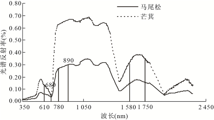
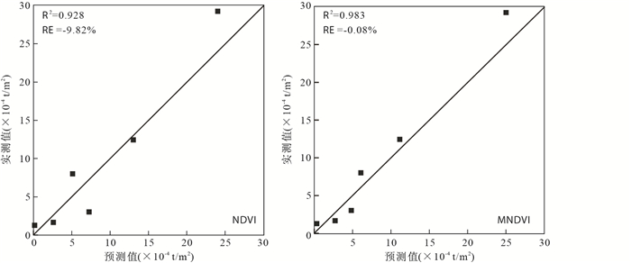
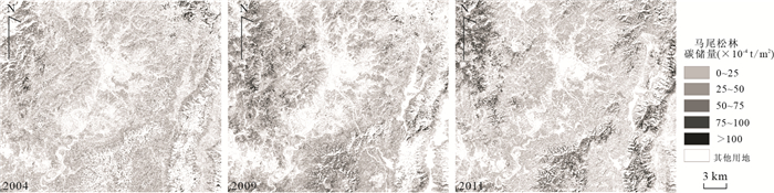
Implementing the ecological restoration by giving priority to planting trees in the eroded area, it is expected to increase the carbon sink of forests. This paper studies the dynamics of Pinus massoniana forest carbon storage of Hetian basin in Changting County of Fujian Province, southeastern China. As Pinus massoniana is the main species used in the ecological restoration, we carried out field surveys with 31 sampling sites in November 2011 to acquire basic data of Pinus massoniana forest in the study area. The regression analysis between the filed-acquired data and the modified normalized difference vegetation index (MNDVI) data derived from a near-synchronised SPOT5 image was performed in order to develop a model to estimate the carbon storage of Pinus massoniana forest in the Hetian basin area. The obtained 2011 model was then calibrated using pseudo-invariant feature (PIF) method to allow the model to be used for estimating the carbon storage of Pinus massoniana forest in 2004 and 2009. As a result, the spatial and temporal dynamics of carbon storage of Pinus massoniana forest in the Hetian basin during 2004 and 2011 were revealed. The results indicate a gradual increase in the carbon storage and carbon density of Pinus massoniana forest in the Hetian basin area in the study period. The carbon storage grew from 9.28×10⁵ t in 2004 to 12.49×10⁵ t in 2011, accompanied by an increase in carbon density from 27.31×10⁻⁴ t/m2 to 35.84×10⁻⁴ t/m2 during the period. This suggests a significant increase of the carbon sink of Pinus massoniana forest in the area, particularly in the last two years from 2009 to 2011.
Implementing the ecological restoration by giving priority to planting trees in the eroded area, it is expected to increase the carbon sink of forests. This paper studies the dynamics of Pinus massoniana forest carbon storage of Hetian basin in Changting County of Fujian Province, southeastern China. As Pinus massoniana is the main species used in the ecological restoration, we carried out field surveys with 31 sampling sites in November 2011 to acquire basic data of Pinus massoniana forest in the study area. The regression analysis between the filed-acquired data and the modified normalized difference vegetation index (MNDVI) data derived from a near-synchronised SPOT5 image was performed in order to develop a model to estimate the carbon storage of Pinus massoniana forest in the Hetian basin area. The obtained 2011 model was then calibrated using pseudo-invariant feature (PIF) method to allow the model to be used for estimating the carbon storage of Pinus massoniana forest in 2004 and 2009. As a result, the spatial and temporal dynamics of carbon storage of Pinus massoniana forest in the Hetian basin during 2004 and 2011 were revealed. The results indicate a gradual increase in the carbon storage and carbon density of Pinus massoniana forest in the Hetian basin area in the study period. The carbon storage grew from 9.28×10⁵ t in 2004 to 12.49×10⁵ t in 2011, accompanied by an increase in carbon density from 27.31×10⁻⁴ t/m2 to 35.84×10⁻⁴ t/m2 during the period. This suggests a significant increase of the carbon sink of Pinus massoniana forest in the area, particularly in the last two years from 2009 to 2011.


2013, 38(5): 1091-1098.
doi: 10.3799/dqkx.2013.107
Abstract:
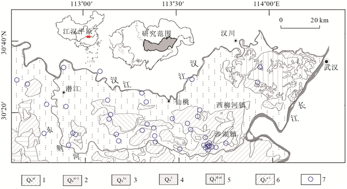
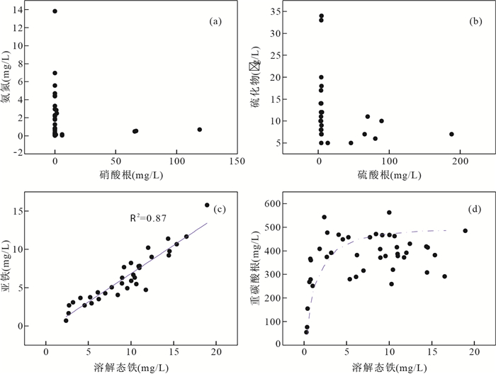
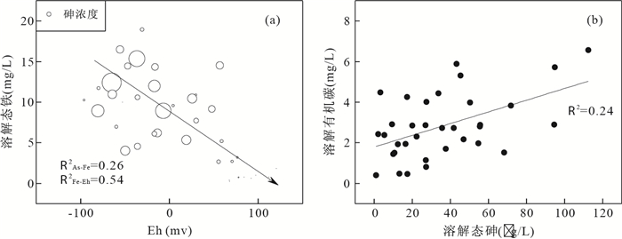
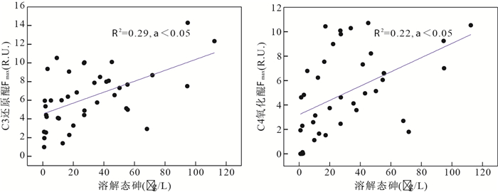
The investigation of redox-sensitive elements characteristics and 3D fluorescent spectroscopy to groundwater from JiangHan plain, were conducted to understand the biogeochemical mechanisms of arsenic mobilization. Groundwater geochemistry indicates that the occurrence of arsenic is closely associated with the geochemical processes of Fe (Ⅲ) reduction and organic matter oxidation. The fluorescent spectroscopy characterization of dissolved organic matter (DOM) shows that the reactive organic matters mediating oxidation-reduction reaction prevail in groundwater and arsenic mobilization is linked with the microbes-mediated reductive dissolution process of iron (hydr)oxides, in which DOM components are probably involved in the process electron shuttle and thus enhance arsenic mobilization through catalyzing the oxidation-reduction process.
The investigation of redox-sensitive elements characteristics and 3D fluorescent spectroscopy to groundwater from JiangHan plain, were conducted to understand the biogeochemical mechanisms of arsenic mobilization. Groundwater geochemistry indicates that the occurrence of arsenic is closely associated with the geochemical processes of Fe (Ⅲ) reduction and organic matter oxidation. The fluorescent spectroscopy characterization of dissolved organic matter (DOM) shows that the reactive organic matters mediating oxidation-reduction reaction prevail in groundwater and arsenic mobilization is linked with the microbes-mediated reductive dissolution process of iron (hydr)oxides, in which DOM components are probably involved in the process electron shuttle and thus enhance arsenic mobilization through catalyzing the oxidation-reduction process.


2013, 38(5): 1099-1106.
doi: 10.3799/dqkx.2013.108
Abstract:
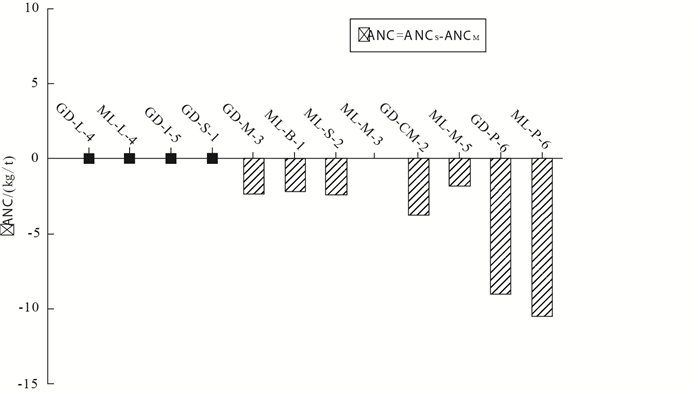
Acid neutralization capacity (ANC) of rocks is an important parameter of static acid generating prediction, and it is also the most controversial parameter. Twelve typical country rocks of Permo-Carboniferous coal-bearing measures from Xishan coal field at Shanxi Province are studied by four evaluation methods of acid neutralization capacity. Filtered Sobek ANC test can effectively eliminate effect of reactive pyrite for ANC determination. The ANC value based on filtered Sobek ANC test is more accurate than that of Modified Sobek ANC test. Sequential Sobek ANC tests are feasible for mudstone and pyrite samples. Mineralogical ANC method is more suitable for evaluating limestone and siderite samples with strong bubbling reaction, but not for mudstone and sandstone samples. The Mineralogical ANC value can't reflect the real acid neutralization capacity of mudstone and sandstone samples. Limestone and siderite samples have strong acid neutralization capacity, and the ANC values of samples do not change with time. Sandstone and mudstone samples have low ANC values, which decrease with time.
Acid neutralization capacity (ANC) of rocks is an important parameter of static acid generating prediction, and it is also the most controversial parameter. Twelve typical country rocks of Permo-Carboniferous coal-bearing measures from Xishan coal field at Shanxi Province are studied by four evaluation methods of acid neutralization capacity. Filtered Sobek ANC test can effectively eliminate effect of reactive pyrite for ANC determination. The ANC value based on filtered Sobek ANC test is more accurate than that of Modified Sobek ANC test. Sequential Sobek ANC tests are feasible for mudstone and pyrite samples. Mineralogical ANC method is more suitable for evaluating limestone and siderite samples with strong bubbling reaction, but not for mudstone and sandstone samples. The Mineralogical ANC value can't reflect the real acid neutralization capacity of mudstone and sandstone samples. Limestone and siderite samples have strong acid neutralization capacity, and the ANC values of samples do not change with time. Sandstone and mudstone samples have low ANC values, which decrease with time.


2013, 38(5): 1107-1115.
doi: 10.3799/dqkx.2013.109
Abstract:
It may be hard to make a reasonable assessment on the combined pollution risk of heavy metals in the sulfide tailings merely by using a single method (e.g. Nemerom index) based on element total content. This paper carries out the comprehensive assessment of the combined pollution risk of Pb, Zn, Cd and As in the sulfide tailings in a mine (northern Guangxi, China), integrating methods such as the geological accumulative index, the potential ecological risk evaluation, and BCR acid extraction procedure. The reference value is taken from the element abundance of the weathering crust of carbonate country rock nearby LTS ore body in the mine. The results display that: (1) Cadmium (strongest ecological risk and mobility in the four elements) and Arsenic (highest pollution level and stronger ecological risk) are major pollution factors in the mine, and should be prevented and controlled; while Zinc (weak ecological risk), and Pb (low pollution level, weak ecological risk and mobility) may be relatively minor. (2) The elements active-acid-extractable content, which is one of the main causes inducing environment damages, correlates variously or inconsistently with its total content. That may be one reason for the problems existing in the assessment methods only based on the factor of element total content.
It may be hard to make a reasonable assessment on the combined pollution risk of heavy metals in the sulfide tailings merely by using a single method (e.g. Nemerom index) based on element total content. This paper carries out the comprehensive assessment of the combined pollution risk of Pb, Zn, Cd and As in the sulfide tailings in a mine (northern Guangxi, China), integrating methods such as the geological accumulative index, the potential ecological risk evaluation, and BCR acid extraction procedure. The reference value is taken from the element abundance of the weathering crust of carbonate country rock nearby LTS ore body in the mine. The results display that: (1) Cadmium (strongest ecological risk and mobility in the four elements) and Arsenic (highest pollution level and stronger ecological risk) are major pollution factors in the mine, and should be prevented and controlled; while Zinc (weak ecological risk), and Pb (low pollution level, weak ecological risk and mobility) may be relatively minor. (2) The elements active-acid-extractable content, which is one of the main causes inducing environment damages, correlates variously or inconsistently with its total content. That may be one reason for the problems existing in the assessment methods only based on the factor of element total content.


2013, 38(5): 1116-1120.
doi: 10.3799/dqkx.2013.110
Abstract:
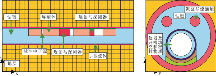
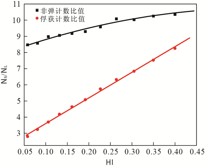
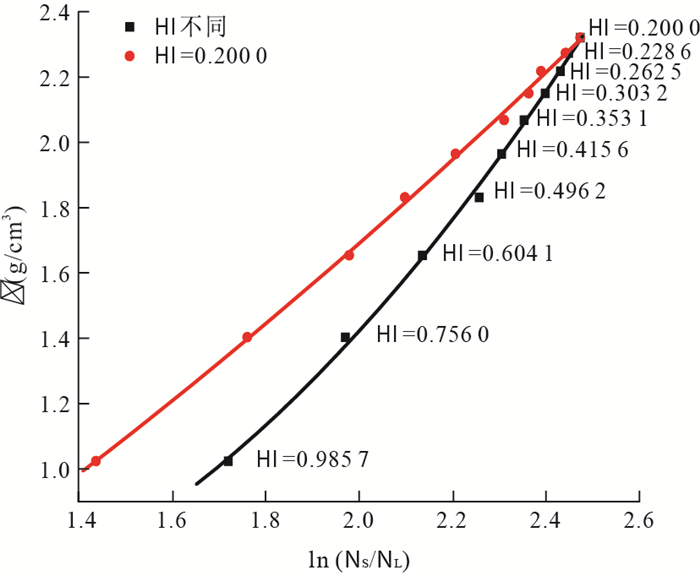
The inelastic and capture gamma ray at different spacing can be recorded with the system of D-T pulsed neutron source and two NaI crystal detectors. The response of inelastic gamma ray counting ratio from near and far detectors and formation density can be obtained after hydrogen index was corrected by the capture gamma ray counts ratio. As a result, the formation density can be measured with pulsed neutron-gamma logging method. The distributions of inelastic and capture gamma ray under different formation conditions are simulated using Monte Carlo method, and then the inelastic gamma ray counting is related to formation density and hydrogen index. Owing to the higher sensitivity of capture gamma ray reflecting to hydrogen index than inelastic gamma ray, the response of formation density and the inelastic gamma ray counting ratio from near and far detectors is founded, which hydrogen index is corrected by capture gamma ray counting. In addition, the binary regression method is utilized to get the density response formula, with which the apparent density after correction is very close to the real one. It is concluded that the formation density can be determined by pulsed neutron gamma logging method while drilling.
The inelastic and capture gamma ray at different spacing can be recorded with the system of D-T pulsed neutron source and two NaI crystal detectors. The response of inelastic gamma ray counting ratio from near and far detectors and formation density can be obtained after hydrogen index was corrected by the capture gamma ray counts ratio. As a result, the formation density can be measured with pulsed neutron-gamma logging method. The distributions of inelastic and capture gamma ray under different formation conditions are simulated using Monte Carlo method, and then the inelastic gamma ray counting is related to formation density and hydrogen index. Owing to the higher sensitivity of capture gamma ray reflecting to hydrogen index than inelastic gamma ray, the response of formation density and the inelastic gamma ray counting ratio from near and far detectors is founded, which hydrogen index is corrected by capture gamma ray counting. In addition, the binary regression method is utilized to get the density response formula, with which the apparent density after correction is very close to the real one. It is concluded that the formation density can be determined by pulsed neutron gamma logging method while drilling.

2013, 38(5): 1121-1127.
doi: 10.3799/dqkx.2013.111
Abstract:
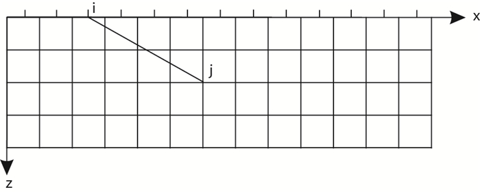
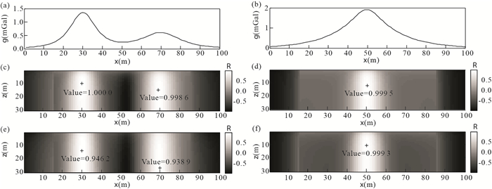
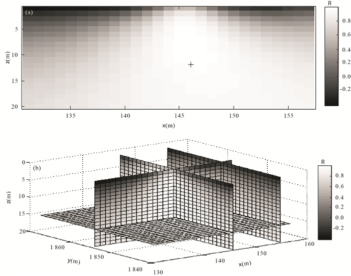
Potential correlation imaging method uses the correlation coefficient of the anomaly generated by the different location of geologic bodies and the observed data to rapidly obtain the location of the causative sources. The existing correlation imaging methods only use the sphere to simulate the shape of the geologic bodies, when the real shape of the source is different from sphere, and the inversion results suffer large errors. To solve this problem, we present improved correlation imaging method, which computes the correlation coefficients of the observed anomaly and the anomalies generated by different types of the model, respectively, and the larger one of the maxima of the correlation coefficients calculated by different models corresponds to the true model. The improved method can both obtain the depth and the nature (structural index) of the source. We use the analytic signal to compute the correlation coefficient of magnetic anomaly, which can avoid the interference of magnetization direction, and the calculation equation is simpler. We try the method on synthetic potential field data, and the inversion results indicate that the method can successfully finish the inversion of potential field data, and produce more stable results. We have also applied it to measured magnetic data, and we obtain the distribution of the unexploited body.
Potential correlation imaging method uses the correlation coefficient of the anomaly generated by the different location of geologic bodies and the observed data to rapidly obtain the location of the causative sources. The existing correlation imaging methods only use the sphere to simulate the shape of the geologic bodies, when the real shape of the source is different from sphere, and the inversion results suffer large errors. To solve this problem, we present improved correlation imaging method, which computes the correlation coefficients of the observed anomaly and the anomalies generated by different types of the model, respectively, and the larger one of the maxima of the correlation coefficients calculated by different models corresponds to the true model. The improved method can both obtain the depth and the nature (structural index) of the source. We use the analytic signal to compute the correlation coefficient of magnetic anomaly, which can avoid the interference of magnetization direction, and the calculation equation is simpler. We try the method on synthetic potential field data, and the inversion results indicate that the method can successfully finish the inversion of potential field data, and produce more stable results. We have also applied it to measured magnetic data, and we obtain the distribution of the unexploited body.


2013, 38(5): 1128-1134.
doi: 10.3799/dqkx.2013.112
Abstract:
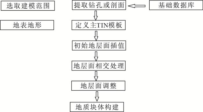
The construction of stratum layer surfaces is the key to stratum modeling. Utilizing the related data resources of quaternary geology, such as surface topographic maps, quaternary geological maps, drilling, sections, and in exact top-down layer order of the quaternary geology, this paper calculates all stratum subareas in turn. Firstly, the overlay analysis of all stratum area charts in a plane map generates the fragmentary polygons set after plane partition intersection, which is called stratum 2D sub-surface template library. Then, the 3D top and bottom stratum models are gained by collecting sub-surfaces from every stratum, using the elevation sample data interpolation of the relevant stratum of drills and sections, which in turn leads to the establishment of then it can 3D geologic body model by topology handler. This method follows the basic flow of the quaternary geological 3D mapping by using the concept of 2D sub-surface template library, transferring the huge computing load from 3D modeling into 2D section by dividing the 3D stratigraphic surface construction into two sections of subarea construction of each stratigraphic surface and stratigraphic sub-surface elevation computing, which enhances the modeling efficiency while 3D stratigraphic modeling precision is guaranteed.
The construction of stratum layer surfaces is the key to stratum modeling. Utilizing the related data resources of quaternary geology, such as surface topographic maps, quaternary geological maps, drilling, sections, and in exact top-down layer order of the quaternary geology, this paper calculates all stratum subareas in turn. Firstly, the overlay analysis of all stratum area charts in a plane map generates the fragmentary polygons set after plane partition intersection, which is called stratum 2D sub-surface template library. Then, the 3D top and bottom stratum models are gained by collecting sub-surfaces from every stratum, using the elevation sample data interpolation of the relevant stratum of drills and sections, which in turn leads to the establishment of then it can 3D geologic body model by topology handler. This method follows the basic flow of the quaternary geological 3D mapping by using the concept of 2D sub-surface template library, transferring the huge computing load from 3D modeling into 2D section by dividing the 3D stratigraphic surface construction into two sections of subarea construction of each stratigraphic surface and stratigraphic sub-surface elevation computing, which enhances the modeling efficiency while 3D stratigraphic modeling precision is guaranteed.


2013, 38(5): 1135-1142.
doi: 10.3799/dqkx.2013.113
Abstract:
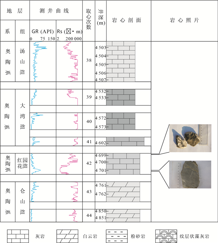
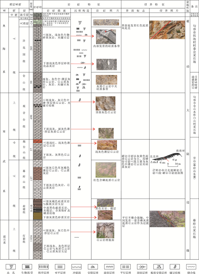
To identify the influence of base level cycle on the differences of the fluvial reservoir physical properties and logging response among the same type of microfacies in different stages of base level cycle, the main controlling factors on the fluvial reservoir physical properties of the channel in the upper member of Guantao Formation of Gudao oilfield are analyzed based on the sediment dynamic analysis of the high resolution stratigraphic sequence and the quantitative analysis of the core testing, statistical data. The control mechanism of base level cycle on the differences of the reservoir differences and logging response among the channel in different stages of base level cycle is identified. The pattern of the reservoir differences and logging response among the channel in different stages of base level cycle is confirmed. The results show that the diversity of sedimentary environment of channel in different stages of base level cycle causes the variation of accommodate space and sediment supply due to the changes of the base level in different scales, the reservoir quality of the upper part of the single channel in short-term base level cycle is lower than that of the basal part, and the logging response of single channel is similar. The reservoir quality of the upper part of the compound channel(formed by different single channels)in middle-term base level cycle is lower than that of the basal part, and the logging response of different single channel is distinct. The reservoir property and logging response among compound channel in the different stages of long-term base level cycle is distributed irregularly.
To identify the influence of base level cycle on the differences of the fluvial reservoir physical properties and logging response among the same type of microfacies in different stages of base level cycle, the main controlling factors on the fluvial reservoir physical properties of the channel in the upper member of Guantao Formation of Gudao oilfield are analyzed based on the sediment dynamic analysis of the high resolution stratigraphic sequence and the quantitative analysis of the core testing, statistical data. The control mechanism of base level cycle on the differences of the reservoir differences and logging response among the channel in different stages of base level cycle is identified. The pattern of the reservoir differences and logging response among the channel in different stages of base level cycle is confirmed. The results show that the diversity of sedimentary environment of channel in different stages of base level cycle causes the variation of accommodate space and sediment supply due to the changes of the base level in different scales, the reservoir quality of the upper part of the single channel in short-term base level cycle is lower than that of the basal part, and the logging response of single channel is similar. The reservoir quality of the upper part of the compound channel(formed by different single channels)in middle-term base level cycle is lower than that of the basal part, and the logging response of different single channel is distinct. The reservoir property and logging response among compound channel in the different stages of long-term base level cycle is distributed irregularly.


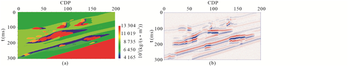
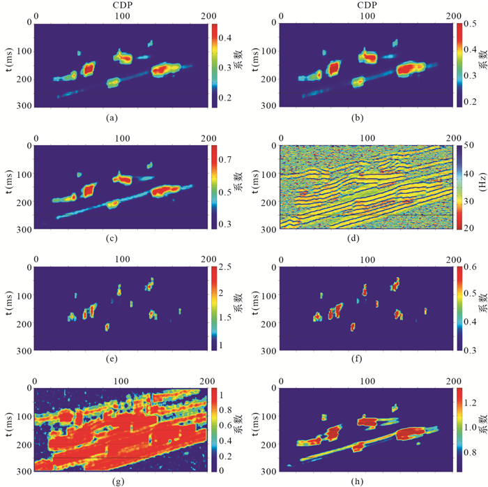
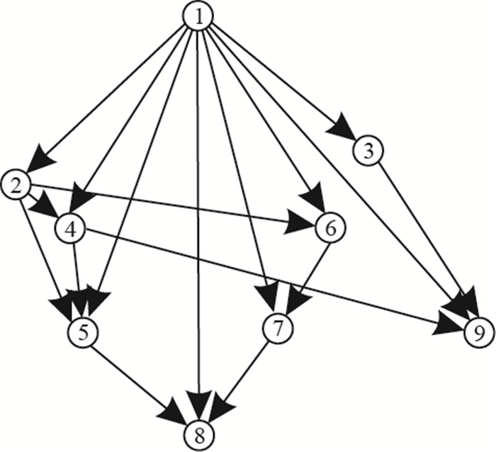
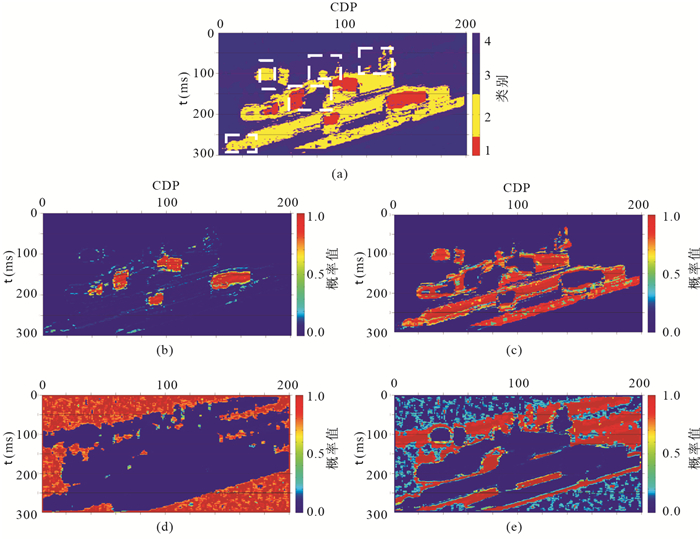
2013, 38(5): 1143-1152.
doi: 10.3799/dqkx.2013.114
Abstract:
There are three challenging issues in traditional seismic facies classification based on seismic attributes. Firstly, it is difficult to introduce priori-information into the processing of classification to enhance the result of seismic facies classification. Secondly, it is difficult to quantitatively evaluate reliability of the result for seismic facies classification. Thirdly, it is difficult to determine the weights of all parameters of Bayesian networks in classification. In order to solve the above-mentioned problems, this paper proposes a new approach of seismic facies classification based on Bayesian networks, which effectively combines the priori-information and probability distribution of the training samples to construct a reasonable classification model, and deduce the probability for each of seismic facies. According to the probability distribution of each seismic facies, we could estimate the reliability of the classification results in a quantitative manner. The principles and workflow are presented in detail for applying Bayesian networks to seismic facies classification. The numerical experiment proves that this method is correct and feasible.
There are three challenging issues in traditional seismic facies classification based on seismic attributes. Firstly, it is difficult to introduce priori-information into the processing of classification to enhance the result of seismic facies classification. Secondly, it is difficult to quantitatively evaluate reliability of the result for seismic facies classification. Thirdly, it is difficult to determine the weights of all parameters of Bayesian networks in classification. In order to solve the above-mentioned problems, this paper proposes a new approach of seismic facies classification based on Bayesian networks, which effectively combines the priori-information and probability distribution of the training samples to construct a reasonable classification model, and deduce the probability for each of seismic facies. According to the probability distribution of each seismic facies, we could estimate the reliability of the classification results in a quantitative manner. The principles and workflow are presented in detail for applying Bayesian networks to seismic facies classification. The numerical experiment proves that this method is correct and feasible.