2013 Vol. 38, No. 6
Display Method:
2013, 38(6): 1153-1168.
doi: 10.3799/dqkx.2013.115
 PDF 1061KB
Abstract:
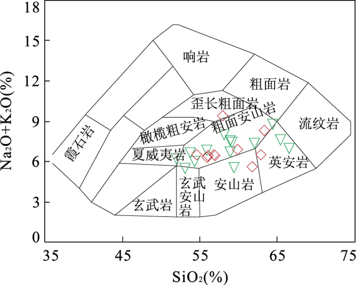
The Middle Jurassic volcanic rocks of Haifanggou formation from the western Liaoning Province is an important component of Mesozoic volcanic rocks in the Yanshan Orogenic belt. The volcanic rocks of Haifanggou formation, which are mainly composed of trachyandesite with dacite and andesite, are metaluminous calc-alkaline and high-K series. Geochemical data indicate that the Middle Jurassic volcanic rocks of Haifanggou from the western Liaoning province have the low Mg adakitic volcanic features, such as SiO2≥51.98%, Al2O3≥15.0%, MgO < 4.18% (Mg# < 0.48), Sr≥436×10-6, Yb≤2.25×10⁻⁶, Y≤23.14×10⁻⁶, Cr≤81.09×10⁻⁶, Ni≤34.66×10⁻⁶, Y/Yb≤14.25, Sr/Y≥39, and Nb/Ta≈20. The rocks are enriched in light rare earth elements (LREE), Ba, U, Sr and Pb, and are depleted in heavy rare earth elements (HREE) and high field strength elements (such as Nb, Ta, Ti), and strongly fractionated ((La/Yb)N≥10.37) with weak negative Eu anomaly or positive Eu anomaly (0.79 to 1.05 in Eu/Eu*). In addition, these adakitic volcanic rocks also have that low (143Nd/144Nd) initial ratios (0.511 603 to 0.511 733, -15.84 to -13.30 in epsilon εNd(t)), moderate (87Sr/86Sr) initial ratios (0.704 9 to 0.705 6, 8.64 to 18.11 in epsilon εSr(t)) and a higher depleted mantle model ages (1.81 to 1.99 Ga in TDM), showing enriched mantle end-member (EMI) characteristics. These features indicate that Haifanggou adakitic magma were derived from the partial melting of a thickened eclogite from the lower crust, and its origin is related to underplating of the basaltic magma. Combining with geochemistry of Mesozoic volcanic rocks in Yanshan Orogenic belt, the Early-Middle Jurassic in the Yanshan orogenic belt is a conversion period from the ancient Asian Ocean tectonic system to the paleo-Pacific tectonic system, while the generation of the Middle Jurassic adakitic volcanic rocks of Haifanggou formation (174 Ma) shows that the Yanshan orogenic belt has come into the evolution stage of the paleo-Pacific tectonic system. The research results can facilitate the understanding of the deep mechanism of Yanshan movement and lithospheric thinning process.
The Middle Jurassic volcanic rocks of Haifanggou formation from the western Liaoning Province is an important component of Mesozoic volcanic rocks in the Yanshan Orogenic belt. The volcanic rocks of Haifanggou formation, which are mainly composed of trachyandesite with dacite and andesite, are metaluminous calc-alkaline and high-K series. Geochemical data indicate that the Middle Jurassic volcanic rocks of Haifanggou from the western Liaoning province have the low Mg adakitic volcanic features, such as SiO2≥51.98%, Al2O3≥15.0%, MgO < 4.18% (Mg# < 0.48), Sr≥436×10-6, Yb≤2.25×10⁻⁶, Y≤23.14×10⁻⁶, Cr≤81.09×10⁻⁶, Ni≤34.66×10⁻⁶, Y/Yb≤14.25, Sr/Y≥39, and Nb/Ta≈20. The rocks are enriched in light rare earth elements (LREE), Ba, U, Sr and Pb, and are depleted in heavy rare earth elements (HREE) and high field strength elements (such as Nb, Ta, Ti), and strongly fractionated ((La/Yb)N≥10.37) with weak negative Eu anomaly or positive Eu anomaly (0.79 to 1.05 in Eu/Eu*). In addition, these adakitic volcanic rocks also have that low (143Nd/144Nd) initial ratios (0.511 603 to 0.511 733, -15.84 to -13.30 in epsilon εNd(t)), moderate (87Sr/86Sr) initial ratios (0.704 9 to 0.705 6, 8.64 to 18.11 in epsilon εSr(t)) and a higher depleted mantle model ages (1.81 to 1.99 Ga in TDM), showing enriched mantle end-member (EMI) characteristics. These features indicate that Haifanggou adakitic magma were derived from the partial melting of a thickened eclogite from the lower crust, and its origin is related to underplating of the basaltic magma. Combining with geochemistry of Mesozoic volcanic rocks in Yanshan Orogenic belt, the Early-Middle Jurassic in the Yanshan orogenic belt is a conversion period from the ancient Asian Ocean tectonic system to the paleo-Pacific tectonic system, while the generation of the Middle Jurassic adakitic volcanic rocks of Haifanggou formation (174 Ma) shows that the Yanshan orogenic belt has come into the evolution stage of the paleo-Pacific tectonic system. The research results can facilitate the understanding of the deep mechanism of Yanshan movement and lithospheric thinning process.


2013, 38(6): 1169-1182.
doi: 10.3799/dqkx.2013.116
Abstract:
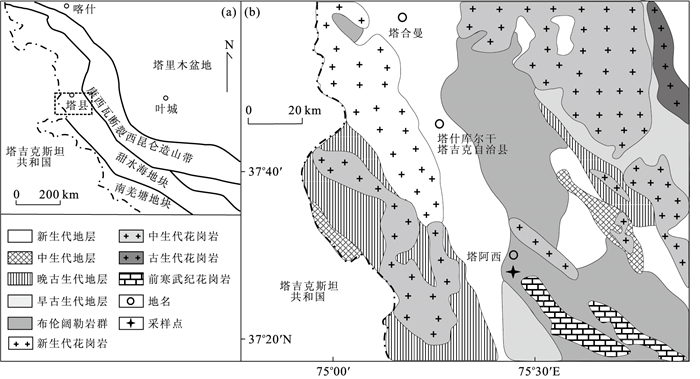
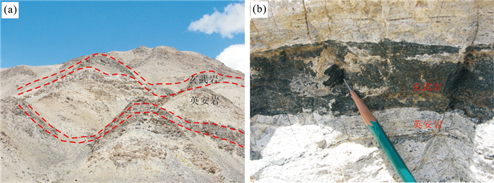
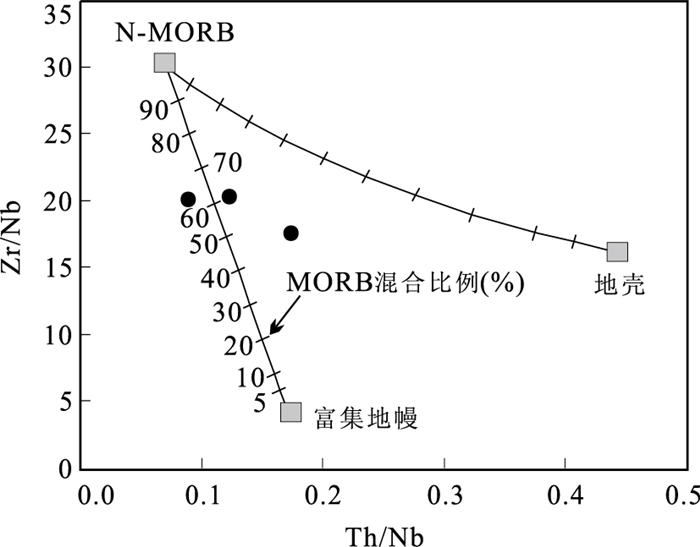
This paper presents petrological and geochemical features and zircon U-Pb age of a suite of bimodal volcanic rocks in the Bulunkuole Group from the Taishuihai Massif, NW China. The zircon U-Pb dating results yield a mean 238U/206Pb age of 521.3±3.3 Ma, representing the extrusion time of the dacites in the Middle Cambrian, which indicates that the previously defined Paleoproterozoic Bulunkuole Group also includes early Paleozoic volcanic rocks. The basalts and dacites belong to low-K affinities. The basalts show enrichment in Rb, Ba, K and LREE, and depletion in Nb-Ta and Th, suggesting that they were derived from a previously metasomatized depleted mantle. The dacites also show more enrichment in LILE and Th, and larger depletion in Nb-Ta, Sr and Ti in comparison with the basalts. Different REE patterns and trace element features between the two rock types, and the absence of differentiation trend from the basalts to dacites, argue against the origin for the dacites as the differentiates of the basalts. Combining the dacites geochemical features and the experimental data suggest that they are melts of lower crustal mafic protoliths heated by contemporaneous underplating basaltic magmas at relatively low pressure conditions. The occurrence of the bimodal volcanic rocks reflects that the region experienced an extensional tectonic-magmatic event during early Paleozoic. The new data suggests that the previously defined "Paleoproterozoic Bulunkuole Group" includes at least three components: (1) the Paleoproterozoic khondalite series; (2) the Indo-Sinian high-pressure metamorphic complexes and (3) the early Paleozoic volcano-sedimentary associations.
This paper presents petrological and geochemical features and zircon U-Pb age of a suite of bimodal volcanic rocks in the Bulunkuole Group from the Taishuihai Massif, NW China. The zircon U-Pb dating results yield a mean 238U/206Pb age of 521.3±3.3 Ma, representing the extrusion time of the dacites in the Middle Cambrian, which indicates that the previously defined Paleoproterozoic Bulunkuole Group also includes early Paleozoic volcanic rocks. The basalts and dacites belong to low-K affinities. The basalts show enrichment in Rb, Ba, K and LREE, and depletion in Nb-Ta and Th, suggesting that they were derived from a previously metasomatized depleted mantle. The dacites also show more enrichment in LILE and Th, and larger depletion in Nb-Ta, Sr and Ti in comparison with the basalts. Different REE patterns and trace element features between the two rock types, and the absence of differentiation trend from the basalts to dacites, argue against the origin for the dacites as the differentiates of the basalts. Combining the dacites geochemical features and the experimental data suggest that they are melts of lower crustal mafic protoliths heated by contemporaneous underplating basaltic magmas at relatively low pressure conditions. The occurrence of the bimodal volcanic rocks reflects that the region experienced an extensional tectonic-magmatic event during early Paleozoic. The new data suggests that the previously defined "Paleoproterozoic Bulunkuole Group" includes at least three components: (1) the Paleoproterozoic khondalite series; (2) the Indo-Sinian high-pressure metamorphic complexes and (3) the early Paleozoic volcano-sedimentary associations.


2013, 38(6): 1183-1196.
doi: 10.3799/dqkx.2013.117
Abstract:
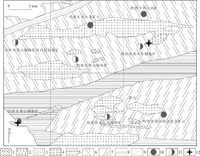
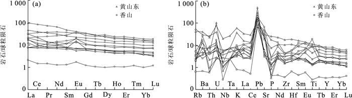
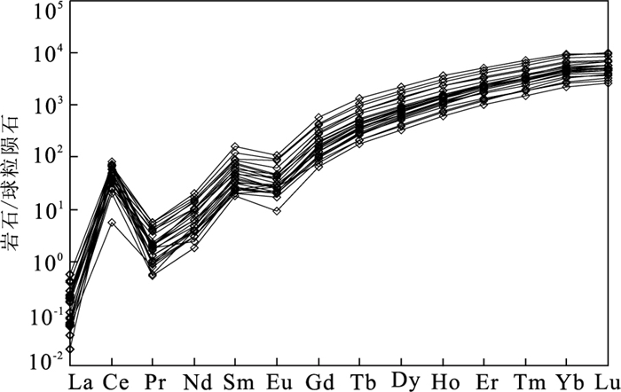
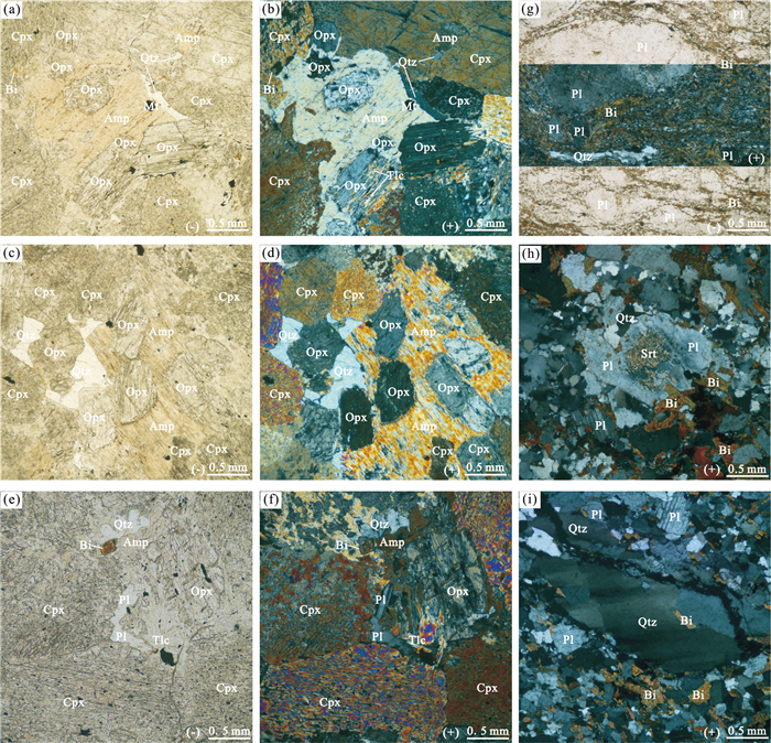
Controlled by the NEE-trending Huangshan-Jingerquan ductile sheer zone, the Huangshandong and Xiangshan mafic-ultramafic complex belongs to the Huangshan-Jingerquan mafic-ultramafic rock belt located in the north of East-Tianshan. Huangshandong is characterized by being of calc-alkalic and tholeiitic series and being composed of pyroxene peridotite and gabbro, whereas Xiangshan mafic-ultramafic rocks are made up of pyroxene peridotite, olivine pyroxenite, hornblende gabbro and diabase, belonging to the tholeiitic series. Both rocks are enriched in large ion lithophile elements (such as K, Sr, Ba) and high field strength elements (such as Pb, U), depleted in high field strength elements (such as Nb, P) and slightly depleted in high field strength elements (such as Zr, Hf). However, they are different in the REE pattern, with Huangshandong showing the enrichment of LREE, similar to OIB features, while the Xiangshan rocks presenting the flat pattern of REE. They are the result of partial melting from the spinel source region and magma experienced olivine, pyroxene, plagioclase and amphibole. But they are subject to crust assimilation contamination to a different extent.Using the LA-ICP-MS method, we obtain the age of Huangshandong and Xiangshan at 277±1.1 Ma and 285±1.1 Ma respectively, which demonstrates they generated from the same tectonic setting, resulted from the lithospheric delamination at the root and the upwelling of asthenosphere in the partial melting of lithospheric mantle, corresponding to post-collision intermittent extension setting.
Controlled by the NEE-trending Huangshan-Jingerquan ductile sheer zone, the Huangshandong and Xiangshan mafic-ultramafic complex belongs to the Huangshan-Jingerquan mafic-ultramafic rock belt located in the north of East-Tianshan. Huangshandong is characterized by being of calc-alkalic and tholeiitic series and being composed of pyroxene peridotite and gabbro, whereas Xiangshan mafic-ultramafic rocks are made up of pyroxene peridotite, olivine pyroxenite, hornblende gabbro and diabase, belonging to the tholeiitic series. Both rocks are enriched in large ion lithophile elements (such as K, Sr, Ba) and high field strength elements (such as Pb, U), depleted in high field strength elements (such as Nb, P) and slightly depleted in high field strength elements (such as Zr, Hf). However, they are different in the REE pattern, with Huangshandong showing the enrichment of LREE, similar to OIB features, while the Xiangshan rocks presenting the flat pattern of REE. They are the result of partial melting from the spinel source region and magma experienced olivine, pyroxene, plagioclase and amphibole. But they are subject to crust assimilation contamination to a different extent.Using the LA-ICP-MS method, we obtain the age of Huangshandong and Xiangshan at 277±1.1 Ma and 285±1.1 Ma respectively, which demonstrates they generated from the same tectonic setting, resulted from the lithospheric delamination at the root and the upwelling of asthenosphere in the partial melting of lithospheric mantle, corresponding to post-collision intermittent extension setting.


2013, 38(6): 1197-1213.
doi: 10.3799/dqkx.2013.118
Abstract:
LA-ICP-MS zircon U-Pb dating and elements geochemical analysis has been carried out for mafic-ultramafic rock from Pingchuan to discuss the petrology characteristics and the time series of diagenesis-mineralization in Pingchuan region and further improve the geochronological framework of diagenesis-mineralization of the Panxi area. The test results show that Huangcaoping gabbro formed in 259.7±1.2 Ma and its capture zircon's crystallization age is 269.8±2.4 Ma, and the subvolcanic's reference diagenetic age is 248± Ma and its metamorphic zircon age is 67± Ma. The results indicate that mafic-ultramafic rock in Pingchuan region is a set of homologous phase sodium-rich tholeiitic rock series, conduciving to the formation of iron-mineralization, outputting in the continental rift environment, magma source coming from the upper mantle spinel lherzolite. The magmatic activity started no later than 269.8±2.4 Ma, and the large-scale magmatic activity occurred at 259.7±1.2 Ma, which constrained the mineralization time of magmatic profiled and volcanic eruptions (underflow) sedimentary, and the subvolcanic diagenetic age limited the upper mineralization time of sub-volcanic hydrothermal, and the metamorphic zircon U-Pb age recorded that Pingchuan region experienced Himalayan intracontinental orogeny. The tectonic-magmatic activity of Pingchuan region is featured with being explosive, phased and metallogenic; the formation of mafic-ultramafic rock in Pingchuan region is probably related to the large-scaled lithospheric thinning; diagenesis-mineralization in Hercynian-Indosinian in Panxi area is the comagmatic product of different phases evolution, controlled by regional uniform deep geodynamics.
LA-ICP-MS zircon U-Pb dating and elements geochemical analysis has been carried out for mafic-ultramafic rock from Pingchuan to discuss the petrology characteristics and the time series of diagenesis-mineralization in Pingchuan region and further improve the geochronological framework of diagenesis-mineralization of the Panxi area. The test results show that Huangcaoping gabbro formed in 259.7±1.2 Ma and its capture zircon's crystallization age is 269.8±2.4 Ma, and the subvolcanic's reference diagenetic age is 248± Ma and its metamorphic zircon age is 67± Ma. The results indicate that mafic-ultramafic rock in Pingchuan region is a set of homologous phase sodium-rich tholeiitic rock series, conduciving to the formation of iron-mineralization, outputting in the continental rift environment, magma source coming from the upper mantle spinel lherzolite. The magmatic activity started no later than 269.8±2.4 Ma, and the large-scale magmatic activity occurred at 259.7±1.2 Ma, which constrained the mineralization time of magmatic profiled and volcanic eruptions (underflow) sedimentary, and the subvolcanic diagenetic age limited the upper mineralization time of sub-volcanic hydrothermal, and the metamorphic zircon U-Pb age recorded that Pingchuan region experienced Himalayan intracontinental orogeny. The tectonic-magmatic activity of Pingchuan region is featured with being explosive, phased and metallogenic; the formation of mafic-ultramafic rock in Pingchuan region is probably related to the large-scaled lithospheric thinning; diagenesis-mineralization in Hercynian-Indosinian in Panxi area is the comagmatic product of different phases evolution, controlled by regional uniform deep geodynamics.


2013, 38(6): 1214-1228.
doi: 10.3799/dqkx.2013.119
Abstract:
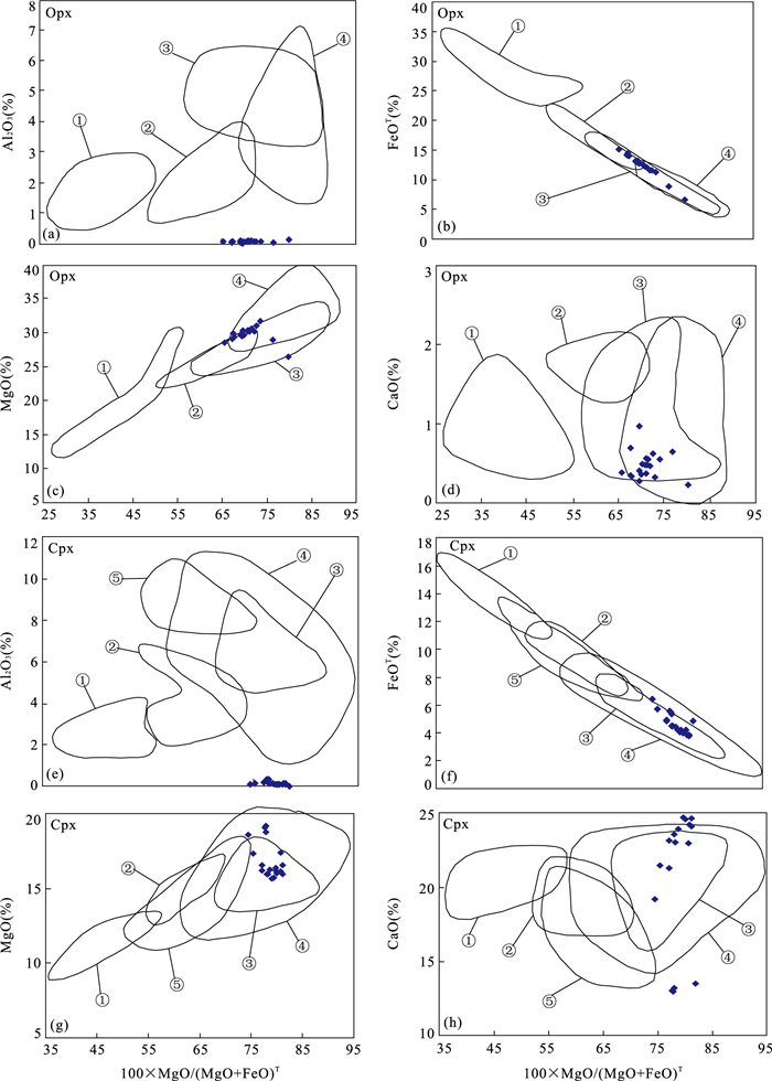
A ultramafic pyroxenite pluton has been discovered in Zhongzaohuo area in the East Kunlun orogen Recently. This paper reports the results of petrological, geochemical and genetic mineralogy research on the pyroxenite pluton. The rock is mainly composed of clinopyroxene, orthopyroxene and amphibole, and minor plagioclase, quartz, biotite and iron opaque minerals. Amphibole and biotite were formed during retrograde metamorphism. The discriminant analysis results suggest that the Opx are magmatogenic, thus the rock should be named pyroxenite rather than granulite. The rock has high MgO, CaO and low Al2O3 and enriched in Rb and Th and depleted in Nb and Ti, showing clear evidence for an enriched mantle source. Field occurrence of the pyroxenite pluton suggests that the pyroxenite pluton was formed after the mylonization of the surrounding rocks. Combined with the tectonic evolution of East Kunlun, we come to the conclusion that the subduction of an Paleo-Tethys(A'nyemaqen) oceanic slab at the Middle Permian led to fluid and Si-rich?melt metasomatism, inducing partial melting of an enriched lithospheric mantle(peridotites) to form the ultramafic pyroxenite magma. The pyroxenite magma underplated the overlying lower crust, captured the metamorphic zircons of the granulite and exchanged some trace elements, but didn't result in the lower crust partial melting to form any felsic magma. The pyroxenite magma emplaced alone eventually.
A ultramafic pyroxenite pluton has been discovered in Zhongzaohuo area in the East Kunlun orogen Recently. This paper reports the results of petrological, geochemical and genetic mineralogy research on the pyroxenite pluton. The rock is mainly composed of clinopyroxene, orthopyroxene and amphibole, and minor plagioclase, quartz, biotite and iron opaque minerals. Amphibole and biotite were formed during retrograde metamorphism. The discriminant analysis results suggest that the Opx are magmatogenic, thus the rock should be named pyroxenite rather than granulite. The rock has high MgO, CaO and low Al2O3 and enriched in Rb and Th and depleted in Nb and Ti, showing clear evidence for an enriched mantle source. Field occurrence of the pyroxenite pluton suggests that the pyroxenite pluton was formed after the mylonization of the surrounding rocks. Combined with the tectonic evolution of East Kunlun, we come to the conclusion that the subduction of an Paleo-Tethys(A'nyemaqen) oceanic slab at the Middle Permian led to fluid and Si-rich?melt metasomatism, inducing partial melting of an enriched lithospheric mantle(peridotites) to form the ultramafic pyroxenite magma. The pyroxenite magma underplated the overlying lower crust, captured the metamorphic zircons of the granulite and exchanged some trace elements, but didn't result in the lower crust partial melting to form any felsic magma. The pyroxenite magma emplaced alone eventually.


2013, 38(6): 1229-1239.
doi: 10.3799/dqkx.2013.120
Abstract:
The CO2 geological storage is an effective approach to mitigate global warming. The Baokang sedimentary system of Changling depression in the south part of Songliao Basin, choosen as the study area for CO2 storage capacity, is explored with sedimentary geology approach. A connected-well's profile map along the flow direction of Baokang System is investigated for the first time. The sedimentary facies, temporal and spatial distribution, sedimentary features, hydrogeology feature and tectonic characteristics of Baokang sedimentary system are studied based on observing cores and identifying rock thin sections under microscope. The results show that Qingshankou to Nenjiang Formation is favorable reservoir-caprock pair for underground CO2 storage and the total amount of potential CO2 storage capacity is estimated as 7.43×10⁹ t, which is about two times the total volume of CO2 emission in China in 2002, or the total volume of CO2 emission in China in 2009.
The CO2 geological storage is an effective approach to mitigate global warming. The Baokang sedimentary system of Changling depression in the south part of Songliao Basin, choosen as the study area for CO2 storage capacity, is explored with sedimentary geology approach. A connected-well's profile map along the flow direction of Baokang System is investigated for the first time. The sedimentary facies, temporal and spatial distribution, sedimentary features, hydrogeology feature and tectonic characteristics of Baokang sedimentary system are studied based on observing cores and identifying rock thin sections under microscope. The results show that Qingshankou to Nenjiang Formation is favorable reservoir-caprock pair for underground CO2 storage and the total amount of potential CO2 storage capacity is estimated as 7.43×10⁹ t, which is about two times the total volume of CO2 emission in China in 2002, or the total volume of CO2 emission in China in 2009.


2013, 38(6): 1240-1252.
doi: 10.3799/dqkx.2013.121
Abstract:
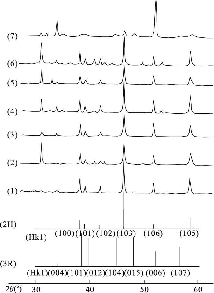
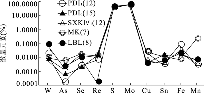
Mesozoic molybdenum deposits are distributed widely in Fujian, and associated with a certain amount of rhenium. This study explores Mesozoic molybdenum deposits in Fujian. It is found by analysis of characteristics of ore petrology and mineralogy of molybdenite of typical molybnum deposits (Pingdi, Shangxikeng, Luobuling, Makeng, etc.) in Fujian Province, five types of the molybdenum deposits have been determined, including the porphyry type, the magmatic hydrothermal type, the volcanic hydrothermal type, the tectonic breccia type and a few skarn type. Our systematic field investigation and petrography study finds that the ores mainly have coarse-medium fine grain, platy texture, small amount of thick tabular texture; the ore mineral(only molybdenite) is of leaden color, obvious polychroism, 2H polymorph (a small amount of 2H+3R, 3R), low contents of impurities including Re((N-N×100)×10-6, most(N-N×10)×10-6), which indicates the ores formed in moderate-high temperature condition and the ore originates from crust-mantle mixed source (most crust source); Mesozoic molybdenum mineralization is of universality in Fujian province; and as a kind of accompanying elements, Re is of some comprehensive utilization value.
Mesozoic molybdenum deposits are distributed widely in Fujian, and associated with a certain amount of rhenium. This study explores Mesozoic molybdenum deposits in Fujian. It is found by analysis of characteristics of ore petrology and mineralogy of molybdenite of typical molybnum deposits (Pingdi, Shangxikeng, Luobuling, Makeng, etc.) in Fujian Province, five types of the molybdenum deposits have been determined, including the porphyry type, the magmatic hydrothermal type, the volcanic hydrothermal type, the tectonic breccia type and a few skarn type. Our systematic field investigation and petrography study finds that the ores mainly have coarse-medium fine grain, platy texture, small amount of thick tabular texture; the ore mineral(only molybdenite) is of leaden color, obvious polychroism, 2H polymorph (a small amount of 2H+3R, 3R), low contents of impurities including Re((N-N×100)×10-6, most(N-N×10)×10-6), which indicates the ores formed in moderate-high temperature condition and the ore originates from crust-mantle mixed source (most crust source); Mesozoic molybdenum mineralization is of universality in Fujian province; and as a kind of accompanying elements, Re is of some comprehensive utilization value.


2013, 38(6): 1253-1262.
doi: 10.3799/dqkx.2013.122
Abstract:
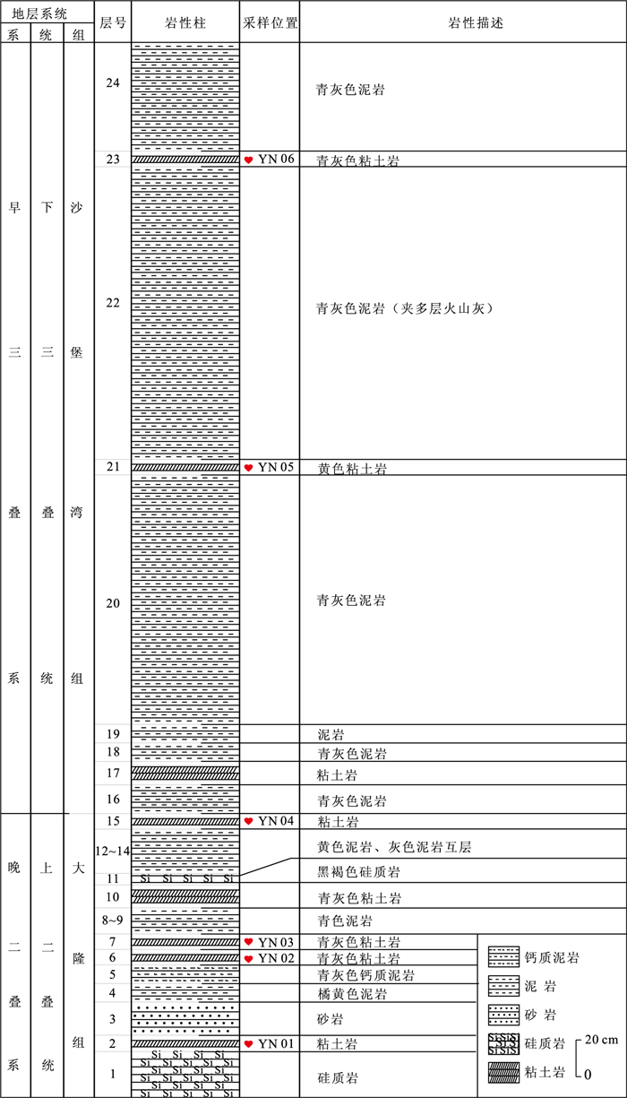
The fine structure and provenance of clays across the Permian-Triassic boundary (PTB) in the Yanlou section were investigated by X-ray diffraction (XRD), scanning electron microscopy (SEM) and differential scanning calorimetry (DSC). The results suggest that the layers have two different provenances. The sample of YN06 exhibits a condensed texture with an oriented arrangement of detrital clay particles and consists mainly of illite and minor chlorite, with irregular outlines or ragged edges. The dehydroxylation temperature occurred at 590 ℃, indicating that clay minerals are composed of trans-vacant (tv) octahedral sheets derived from weathering of detrital illite. Other samples are composed mainly of I-S, illite and minor smectite, chlorite, with dehydroxylation temperature all above 600 ℃, suggesting that clay minerals consist of a mixture of tv and cv sheets and were derived from a mixture of terrigenous and volcanic sources.
The fine structure and provenance of clays across the Permian-Triassic boundary (PTB) in the Yanlou section were investigated by X-ray diffraction (XRD), scanning electron microscopy (SEM) and differential scanning calorimetry (DSC). The results suggest that the layers have two different provenances. The sample of YN06 exhibits a condensed texture with an oriented arrangement of detrital clay particles and consists mainly of illite and minor chlorite, with irregular outlines or ragged edges. The dehydroxylation temperature occurred at 590 ℃, indicating that clay minerals are composed of trans-vacant (tv) octahedral sheets derived from weathering of detrital illite. Other samples are composed mainly of I-S, illite and minor smectite, chlorite, with dehydroxylation temperature all above 600 ℃, suggesting that clay minerals consist of a mixture of tv and cv sheets and were derived from a mixture of terrigenous and volcanic sources.


2013, 38(6): 1263-1270.
doi: 10.3799/dqkx.2013.123
Abstract:
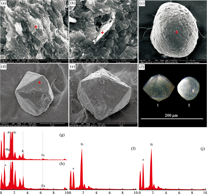
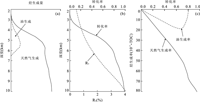
It is very complicated to quantitatively estimate the overpressure caused by natural gas generation in the source rocks with type Ⅲ kerogen firstly due to the small amount of the associated oil to the dominant gas generated and secondly due to the fact that thermal cracking of liquid oil occurs with the increasing depth and temperature. In this paper, a quantitative estimation model for the overpressure change due to natural gas generation is proposed, taking into consideration the episodic natural gas leakage and expulsion, and parameters such as effect of hydrogen index on hydrocarbon generation, thermal cracking of liquid oil to natural gas, the compressibility of kerogen, oil and water, natural gas solution within the water and remaining oil, and so on. In addition, sensitivity analyses of parameters such as residual natural gas coefficient, TOC and hydrogen index have been carried out. Many parameters can affect overpressure due to natural gas generation including source rock porosity, maturity, organic matter abundance, residual natural gas coefficient and so on. Sensitivity analyses indicate that the hydrogen index is the most effective parameter on the pressure change due to natural gas generation in the source rocks and the residual natural gas coefficient has the least effect on the pressure change. Overpressure can be generated when the residual natural gas coefficient is as low to 0.2, suggesting that the pressure seal in the source rock is not the most important parameter for the overpressure development caused by natural gas generation in the source rocks.
It is very complicated to quantitatively estimate the overpressure caused by natural gas generation in the source rocks with type Ⅲ kerogen firstly due to the small amount of the associated oil to the dominant gas generated and secondly due to the fact that thermal cracking of liquid oil occurs with the increasing depth and temperature. In this paper, a quantitative estimation model for the overpressure change due to natural gas generation is proposed, taking into consideration the episodic natural gas leakage and expulsion, and parameters such as effect of hydrogen index on hydrocarbon generation, thermal cracking of liquid oil to natural gas, the compressibility of kerogen, oil and water, natural gas solution within the water and remaining oil, and so on. In addition, sensitivity analyses of parameters such as residual natural gas coefficient, TOC and hydrogen index have been carried out. Many parameters can affect overpressure due to natural gas generation including source rock porosity, maturity, organic matter abundance, residual natural gas coefficient and so on. Sensitivity analyses indicate that the hydrogen index is the most effective parameter on the pressure change due to natural gas generation in the source rocks and the residual natural gas coefficient has the least effect on the pressure change. Overpressure can be generated when the residual natural gas coefficient is as low to 0.2, suggesting that the pressure seal in the source rock is not the most important parameter for the overpressure development caused by natural gas generation in the source rocks.


2013, 38(6): 1271-1280.
doi: 10.3799/dqkx.2013.124
Abstract:
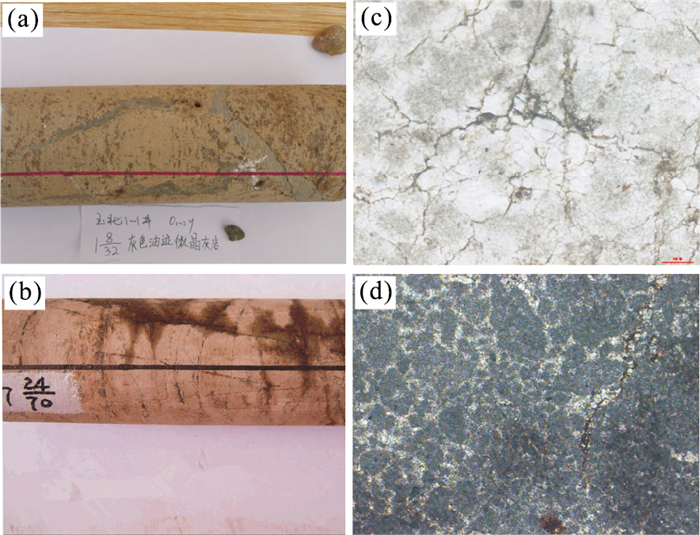
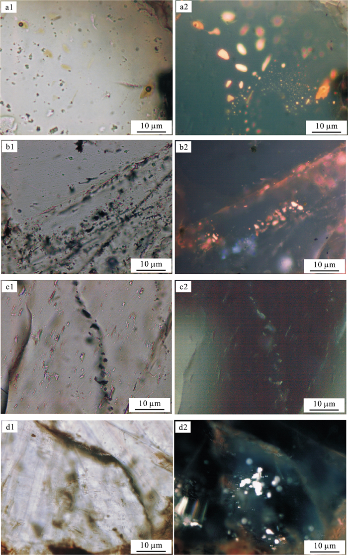
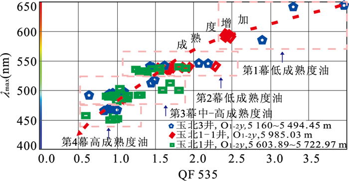
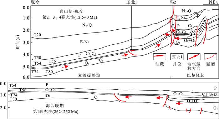
Three types of basic carrier systems are identified for analyzing the hydrocarbon migration and accumulation process of Ordovician reservoir in Yubei area, Southwest Tarim Basin, which are known as fault type, unconformity type and carrier layer type, where the carrier ability is strong in the Middle Part of Yubei area but weak in the Eastern Part. The organic and inorganic fluid inclusion analyses of 25 Ordovician samples from 3 wells in Yubei area indicate that there were two phases of hydrocarbon charging in Ordovician. In the period from 262 Ma to 252 Ma before present (in Late Hercynian), low-mature oil with yellow fluorescence was charged. In the second period from 12.5 Ma to 0 Ma before present (in Late Himalayan), high-maturity oil with blue-white fluorescence was charged. Two groups of hydrocarbon source rocks, namely, the Lower Cambrian source rock and the Upper Cambrian-Lower Ordovician source rock, are developed in Yubei area. The cover is the mudstone and marl of Lower Carboniferous Bachu Formation Strata. The reservoir is the karst weathering of Lower-Middle Ordovician Strata. The cover and reservoir are composed of discontinuous interlayer combinations.
Three types of basic carrier systems are identified for analyzing the hydrocarbon migration and accumulation process of Ordovician reservoir in Yubei area, Southwest Tarim Basin, which are known as fault type, unconformity type and carrier layer type, where the carrier ability is strong in the Middle Part of Yubei area but weak in the Eastern Part. The organic and inorganic fluid inclusion analyses of 25 Ordovician samples from 3 wells in Yubei area indicate that there were two phases of hydrocarbon charging in Ordovician. In the period from 262 Ma to 252 Ma before present (in Late Hercynian), low-mature oil with yellow fluorescence was charged. In the second period from 12.5 Ma to 0 Ma before present (in Late Himalayan), high-maturity oil with blue-white fluorescence was charged. Two groups of hydrocarbon source rocks, namely, the Lower Cambrian source rock and the Upper Cambrian-Lower Ordovician source rock, are developed in Yubei area. The cover is the mudstone and marl of Lower Carboniferous Bachu Formation Strata. The reservoir is the karst weathering of Lower-Middle Ordovician Strata. The cover and reservoir are composed of discontinuous interlayer combinations.


2013, 38(6): 1281-1288.
doi: 10.3799/dqkx.2013.000
Abstract:
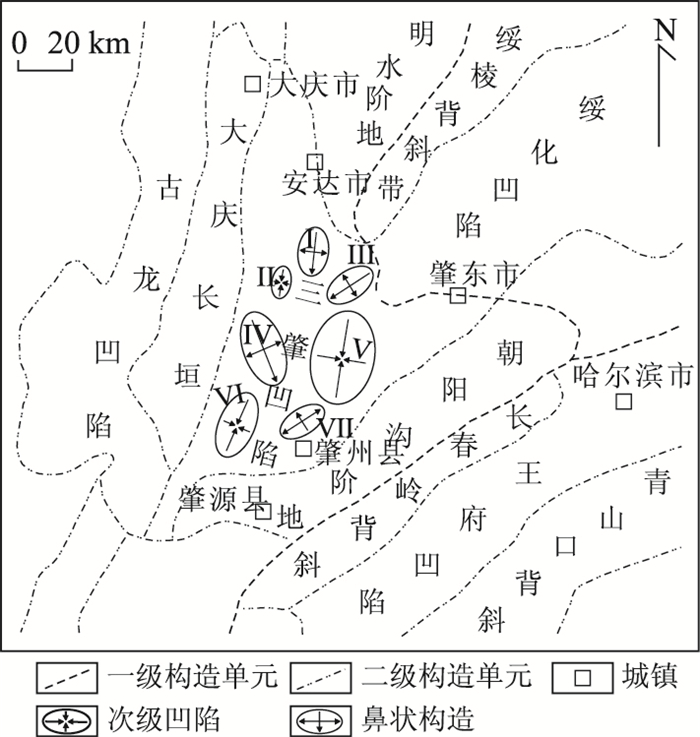
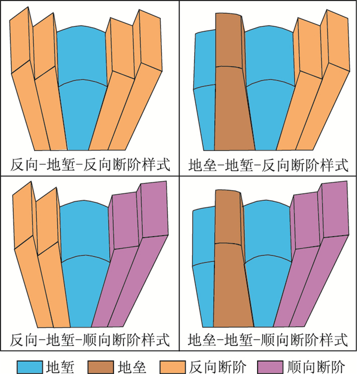
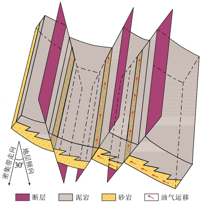
The controlling effect of fault dense belts on the preferred direction of oil-gas migration is discussed and favorable parts of fault dense belts for oil accumulation inside and outside oil source area are discussed based on the characteristics of fault dense belts of Fuyang Formation in Sanzhao Depression, combining with the oil and gas distribution of in Fuyang Formation of study area in this paper. The results show that there are four types of fault dense belts in Fuyang Formation of Sanzhao Depression, namely antithetic-graben-antithetic fault terrace, horst-graben-antithetic fault terrace, antithetic-graben-consequent fault terrace, and horst-graben-consequent fault terrace. The strike of fault dense belt is the preferred direction of oil-gas migration and horsts and antithetic inside oil source area of fault dense belts are favorable parts for oil accumulation where the strikes of fault dense belt and the layer are parallel or small-angle intersection. Inside oil source area horst and antithetic of fault dense belts are favorable parts for oil accumulation. And horsts and antithetic outside oil source area are favorable parts for oil accumulation and the grabens are secondary favorable ones where the angle of the strikes of fault dense belt and layer ranges from 0 to 45 degrees. The antithetic and horsts are preferential for oil accumulation where the angle ranges from 45 to 90 degrees.
The controlling effect of fault dense belts on the preferred direction of oil-gas migration is discussed and favorable parts of fault dense belts for oil accumulation inside and outside oil source area are discussed based on the characteristics of fault dense belts of Fuyang Formation in Sanzhao Depression, combining with the oil and gas distribution of in Fuyang Formation of study area in this paper. The results show that there are four types of fault dense belts in Fuyang Formation of Sanzhao Depression, namely antithetic-graben-antithetic fault terrace, horst-graben-antithetic fault terrace, antithetic-graben-consequent fault terrace, and horst-graben-consequent fault terrace. The strike of fault dense belt is the preferred direction of oil-gas migration and horsts and antithetic inside oil source area of fault dense belts are favorable parts for oil accumulation where the strikes of fault dense belt and the layer are parallel or small-angle intersection. Inside oil source area horst and antithetic of fault dense belts are favorable parts for oil accumulation. And horsts and antithetic outside oil source area are favorable parts for oil accumulation and the grabens are secondary favorable ones where the angle of the strikes of fault dense belt and layer ranges from 0 to 45 degrees. The antithetic and horsts are preferential for oil accumulation where the angle ranges from 45 to 90 degrees.


2013, 38(6): 1289-1298.
doi: 10.3799/dqkx.2013.000
Abstract:
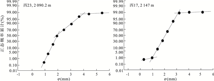
The Chang 8 oil-bearing interval of the Upper Triassic Yanchang Formation in the north-western Ordos Basin was deposited in a stable tectonic setting and it was favorable in terms of geological condition for the shallow-water deltas with the humid climate and the slope gradient at only 0.1°. It is found that shallow water delta was developed during Chang 8 deposition by a great number of core observations, seismic reflection characteristics analysis and modern shallow water lake sediments. It is chcharacterized with low component maturity and middle textural maturity, traction current deposits indicated by grain-size probability curves. In the study area, the mouth bar and the gravity flow deposits are not well developed, and the river has been branched off or diverted frequently due to the lake water obstruction and are widely distributed to a long distance with larger scales. The delta front facies belt is characterized by its wide distribution, the gently connecting of delta plain and delta front with no obvious transition. And three-member structure of the Gilbert Delta is not developed. Therefore, the sandbodies of distributary channels are widely distributed, overlapping vertically, and extending laterally, which is favorable for the formation of lithologic hydrocarbon reservoir.
The Chang 8 oil-bearing interval of the Upper Triassic Yanchang Formation in the north-western Ordos Basin was deposited in a stable tectonic setting and it was favorable in terms of geological condition for the shallow-water deltas with the humid climate and the slope gradient at only 0.1°. It is found that shallow water delta was developed during Chang 8 deposition by a great number of core observations, seismic reflection characteristics analysis and modern shallow water lake sediments. It is chcharacterized with low component maturity and middle textural maturity, traction current deposits indicated by grain-size probability curves. In the study area, the mouth bar and the gravity flow deposits are not well developed, and the river has been branched off or diverted frequently due to the lake water obstruction and are widely distributed to a long distance with larger scales. The delta front facies belt is characterized by its wide distribution, the gently connecting of delta plain and delta front with no obvious transition. And three-member structure of the Gilbert Delta is not developed. Therefore, the sandbodies of distributary channels are widely distributed, overlapping vertically, and extending laterally, which is favorable for the formation of lithologic hydrocarbon reservoir.


2013, 38(6): 1299-1308.
doi: 10.3799/dqkx.2013.127
Abstract:
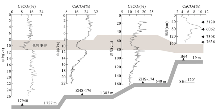
Gas hydrate in the deep sea is closely related to the global warming. One of the most important gas hydrate stability zones (GHSZ) is located in the Shenhu of the northern South China Sea (SCS). All records of carbonate content in cores ZHS-176, ZHS-174, 17940 and MD2905 reveal a carbonate minimum (CM) from 11.3-8.0 ka B.P., which is characterized with an asymmetric pattern of a rapid decrease of 9% value followed by a gradual recovery. The benthic foraminifer δ13C levels in the shells of Cibicidoides wuellerstorfi and Cibicidoides kullenbergi are depleted by 1.4‰ and 0.7‰, respectively, during the CM period. Meanwhile, the mass accumulation rate (MAR) of the organisms suddenly increased nearly twofold on the seabed. These findings indicate a likely release of a large amount of methane from the gas hydrates since the late Younger Dryas (YD). Oxidation and absorption of the methane should have lowered pH of the bottom seawater, thereby triggering a shoaling of the carbonate lysocline. Temperature increasing of the bottom seawater in the northern SCS provides a possibility to induce gas hydrates dissociation.
Gas hydrate in the deep sea is closely related to the global warming. One of the most important gas hydrate stability zones (GHSZ) is located in the Shenhu of the northern South China Sea (SCS). All records of carbonate content in cores ZHS-176, ZHS-174, 17940 and MD2905 reveal a carbonate minimum (CM) from 11.3-8.0 ka B.P., which is characterized with an asymmetric pattern of a rapid decrease of 9% value followed by a gradual recovery. The benthic foraminifer δ13C levels in the shells of Cibicidoides wuellerstorfi and Cibicidoides kullenbergi are depleted by 1.4‰ and 0.7‰, respectively, during the CM period. Meanwhile, the mass accumulation rate (MAR) of the organisms suddenly increased nearly twofold on the seabed. These findings indicate a likely release of a large amount of methane from the gas hydrates since the late Younger Dryas (YD). Oxidation and absorption of the methane should have lowered pH of the bottom seawater, thereby triggering a shoaling of the carbonate lysocline. Temperature increasing of the bottom seawater in the northern SCS provides a possibility to induce gas hydrates dissociation.


2013, 38(6): 1309-1320.
doi: 10.3799/dqkx.2013.000
Abstract:
The sulfate-methane interface (SMI) is an important biogeochemical indication for the area with high methane flux and gas hydrate occurrence. In this paper, 37 surface cores were collected in the Dongsha Area of northern South China Sea, and the characteristics of SO42- and H2S concentrations change of the pore water and CH4 concentration change of the headspaces in the sediments were analyzed. Furthermore, the SMI distribution characteristics were discussed and the methane fluxes were calculated using the sulphate change grades in the Dongsha area of northern South China Sea. The results show that there are two gas hydrate potential areas in the study area. One is the Haiyang-4 site in the southern deep water area, and the other is the Jiulong methane reef in the northern shallow water area. The relatively shallow SMI distribution and high methane flux (3.8×10⁻³-5.9×10⁻³ mmol/(cm2·a)) in the Dongsha area, northern South China Sea are similar to the geochemical characteristics in foreign areas where the gas hydrate occurs. It is convinced that the high methane flux is most probably caused by the occurrence of gas hydrate deposit below the seafloor, which indicates there are gas hydrate reservoirs underneath in the Dongsha area, northern South China Sea.
The sulfate-methane interface (SMI) is an important biogeochemical indication for the area with high methane flux and gas hydrate occurrence. In this paper, 37 surface cores were collected in the Dongsha Area of northern South China Sea, and the characteristics of SO42- and H2S concentrations change of the pore water and CH4 concentration change of the headspaces in the sediments were analyzed. Furthermore, the SMI distribution characteristics were discussed and the methane fluxes were calculated using the sulphate change grades in the Dongsha area of northern South China Sea. The results show that there are two gas hydrate potential areas in the study area. One is the Haiyang-4 site in the southern deep water area, and the other is the Jiulong methane reef in the northern shallow water area. The relatively shallow SMI distribution and high methane flux (3.8×10⁻³-5.9×10⁻³ mmol/(cm2·a)) in the Dongsha area, northern South China Sea are similar to the geochemical characteristics in foreign areas where the gas hydrate occurs. It is convinced that the high methane flux is most probably caused by the occurrence of gas hydrate deposit below the seafloor, which indicates there are gas hydrate reservoirs underneath in the Dongsha area, northern South China Sea.


2013, 38(6): 1321-1326.
doi: 10.3799/dqkx.2013.000
Abstract:
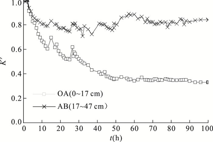
Clogging phenomenon especially physical clogging occurs in aquifer medium during the artificial recharge process when the surface water and rain-flood water are used as recharge water, which has severe impact on the recharge effect. To study the physical clogging mechanism, a simulated experiment is carried out and a mathematical model is used to forecast the occurrence and development process of clogging. The results show that the permeability experiences a large-scale decline at the initial period of recharge, and becomes steadier later; and clogging leads to the non-homogeneity of aquifer: the shorter of the percolation distance, the greater of the clogging level. The suspended particle concentration is supposed to be controlled below 25 mg/L, and periodic backwashing with a frequency of 1 time/day should be taken when the concentration is high in rainy season.
Clogging phenomenon especially physical clogging occurs in aquifer medium during the artificial recharge process when the surface water and rain-flood water are used as recharge water, which has severe impact on the recharge effect. To study the physical clogging mechanism, a simulated experiment is carried out and a mathematical model is used to forecast the occurrence and development process of clogging. The results show that the permeability experiences a large-scale decline at the initial period of recharge, and becomes steadier later; and clogging leads to the non-homogeneity of aquifer: the shorter of the percolation distance, the greater of the clogging level. The suspended particle concentration is supposed to be controlled below 25 mg/L, and periodic backwashing with a frequency of 1 time/day should be taken when the concentration is high in rainy season.


2013, 38(6): 1327-1330.
doi: 10.3799/dqkx.2013.000
Abstract:
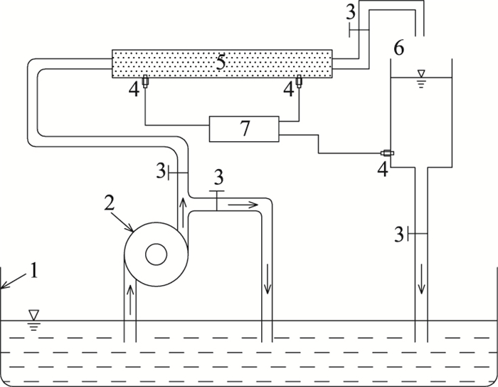
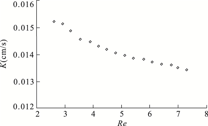
The shared understanding of law on movement of groundwater is that linear Darcy's law is the most basic equation of groundwater seepage. All the mathematical problems of groundwater flow can be derived based on Darcy's law if the the Reynolds number is less than a certain value between 1 and 10 (Re < (1-10)). The experimental data obtained by Darcy are analysed again and similar seepage experiments are carried out with permeable stone porous media. Both results show that even though the Reynolds number is less than a certain value between 1 and 10 (Re < (1-10)), the movement of groundwater would not obey Darcy's law but the nonlinear law. As the Reynolds number increases, the seepage friction grows gradually. It is concluded that Darcy's linear law is the approximate description of nonlinear law when the change of slope is small.
The shared understanding of law on movement of groundwater is that linear Darcy's law is the most basic equation of groundwater seepage. All the mathematical problems of groundwater flow can be derived based on Darcy's law if the the Reynolds number is less than a certain value between 1 and 10 (Re < (1-10)). The experimental data obtained by Darcy are analysed again and similar seepage experiments are carried out with permeable stone porous media. Both results show that even though the Reynolds number is less than a certain value between 1 and 10 (Re < (1-10)), the movement of groundwater would not obey Darcy's law but the nonlinear law. As the Reynolds number increases, the seepage friction grows gradually. It is concluded that Darcy's linear law is the approximate description of nonlinear law when the change of slope is small.


2013, 38(6): 1331-1338.
doi: 10.3799/dqkx.2013.000
Abstract:
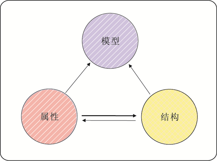
Dynamic ore-body modeling has always been significant but also challenging both in theory and practice. To solve this problem, this paper proposes an alternative method named ore-body Property-Structure (P-S) dynamical modeling. Ore property model in the mining area is firstly built, and then the needed 3D ore-body model is dynamically extracted and constructed according to certain constrained parameters such as mineral industrial indexes. Based on analysis of the driven mechanism in conventional ore-body modeling method and the essential feature of an ore-body in 3D modeling, the principles, characters and operational process of P-S method are discussed in detail. Either the theoretical analysis or practical application proves that the proposed P-S ore-body modeling method is feasible and efficient in high quality ore-body modeling. What's more, it improves the 3D geological modeling theory to some extent.
Dynamic ore-body modeling has always been significant but also challenging both in theory and practice. To solve this problem, this paper proposes an alternative method named ore-body Property-Structure (P-S) dynamical modeling. Ore property model in the mining area is firstly built, and then the needed 3D ore-body model is dynamically extracted and constructed according to certain constrained parameters such as mineral industrial indexes. Based on analysis of the driven mechanism in conventional ore-body modeling method and the essential feature of an ore-body in 3D modeling, the principles, characters and operational process of P-S method are discussed in detail. Either the theoretical analysis or practical application proves that the proposed P-S ore-body modeling method is feasible and efficient in high quality ore-body modeling. What's more, it improves the 3D geological modeling theory to some extent.


2013, 38(6): 1339-1346.
doi: 10.3799/dqkx.2013.000
Abstract:
In this study, we firstly prove by geometry analysis that the edge detection method of tilt angle and theta map share the same theoretical framework, then we uniform them as angle edge detection method. In order to improve the precision and the detectability of details, the angle edge detection method is established based on a standard deviation calculation involving the following two steps. Step 1 is calculation of standard deviation of the three directional derivatives within windows, while Step 2 is calculation of the trigonometric function of inverse sine, cosine angle and arc tangent. The new method is simple and easy to operate. The model tests demonstrate that the improved method can identify the details and detect more anomaly information. The improved methods were applied to Yanji Basin, which not only confirms 12 faults that are already available in the geological information but also finds three larger fractures accordant with the seismic data. The research results provide new geophysical information for the further study of Yanji Basin.
In this study, we firstly prove by geometry analysis that the edge detection method of tilt angle and theta map share the same theoretical framework, then we uniform them as angle edge detection method. In order to improve the precision and the detectability of details, the angle edge detection method is established based on a standard deviation calculation involving the following two steps. Step 1 is calculation of standard deviation of the three directional derivatives within windows, while Step 2 is calculation of the trigonometric function of inverse sine, cosine angle and arc tangent. The new method is simple and easy to operate. The model tests demonstrate that the improved method can identify the details and detect more anomaly information. The improved methods were applied to Yanji Basin, which not only confirms 12 faults that are already available in the geological information but also finds three larger fractures accordant with the seismic data. The research results provide new geophysical information for the further study of Yanji Basin.


2013, 38(6): 1347-1355.
doi: 10.3799/dqkx.2013.000
Abstract:
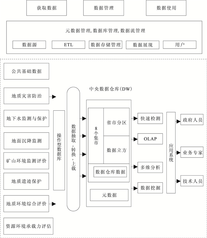
China Institute of Geo-Environment Monitoring is building a national-level geological environment information platform, as an important part of a national data center aiming to collect, integrate and analyze the national geological environment data characterized by its huge size, multi-source, both structured and unstructured storage. In order to extract valuable information from the data center rapidly, a data warehouse based on the concept of big data is applied to integrate operational data into data center for professional analysis. The system running results show that the data warehouse, which consists of 8 data marts (geo-hazard prevention, underground water monitoring and protection, mining geology environment and etc) and each of them can be divided successively into various subjects and sub-subjects by loading data into star schema in multiple dimensions, different levels of granularities and various perspectives, can provide multi-dimensional data analysis and support decision-making, and therefore presents a new strategy on discovering valuable information from geo-environmental data.
China Institute of Geo-Environment Monitoring is building a national-level geological environment information platform, as an important part of a national data center aiming to collect, integrate and analyze the national geological environment data characterized by its huge size, multi-source, both structured and unstructured storage. In order to extract valuable information from the data center rapidly, a data warehouse based on the concept of big data is applied to integrate operational data into data center for professional analysis. The system running results show that the data warehouse, which consists of 8 data marts (geo-hazard prevention, underground water monitoring and protection, mining geology environment and etc) and each of them can be divided successively into various subjects and sub-subjects by loading data into star schema in multiple dimensions, different levels of granularities and various perspectives, can provide multi-dimensional data analysis and support decision-making, and therefore presents a new strategy on discovering valuable information from geo-environmental data.


2013, 38(6): 1356-1362.
doi: 10.3799/dqkx.2013.000
Abstract:
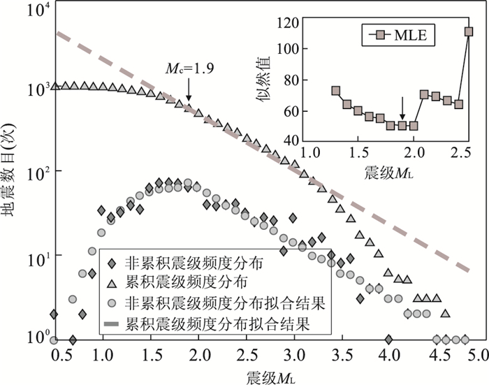
In this paper monitoring capacity of Inner Mongolia seismic network is evaluated, aiming at offering information for scientific layout of seismic stations. We analyze the temporal and spatial character of record stations number, maximum station coverage azimuth and minimum magnitude of completeness (Mc) based on the observation reports and catalogues in Inner Mongolia regions. The results reflect the development of the monitoring capacity. The Mc in Hohhot region was around ML2.0 and over ML3.0 in the juncture of Mongolia and Inner Mongolia during "analogy" era (1990-2001). The monitoring capacity has been improved in the Midwest of Inner Mongolia region and the adjacent areas during "analogy digital parallel" era (2002-2007), with Mc reaching as low as ML2.2 in most of Inner Mongolia and its adjacent areas during "digital" era and the 10th five-year project period (2008-2012) because the layout of stations is more reasonable and the influence of long narrow region shape has been overcome. This study facilitates the future seismic activity analysis and the seismic hazard assessment in this region.
In this paper monitoring capacity of Inner Mongolia seismic network is evaluated, aiming at offering information for scientific layout of seismic stations. We analyze the temporal and spatial character of record stations number, maximum station coverage azimuth and minimum magnitude of completeness (Mc) based on the observation reports and catalogues in Inner Mongolia regions. The results reflect the development of the monitoring capacity. The Mc in Hohhot region was around ML2.0 and over ML3.0 in the juncture of Mongolia and Inner Mongolia during "analogy" era (1990-2001). The monitoring capacity has been improved in the Midwest of Inner Mongolia region and the adjacent areas during "analogy digital parallel" era (2002-2007), with Mc reaching as low as ML2.2 in most of Inner Mongolia and its adjacent areas during "digital" era and the 10th five-year project period (2008-2012) because the layout of stations is more reasonable and the influence of long narrow region shape has been overcome. This study facilitates the future seismic activity analysis and the seismic hazard assessment in this region.


2013, 38(6): 1363-1370.
doi: 10.3799/dqkx.2013.000
Abstract:
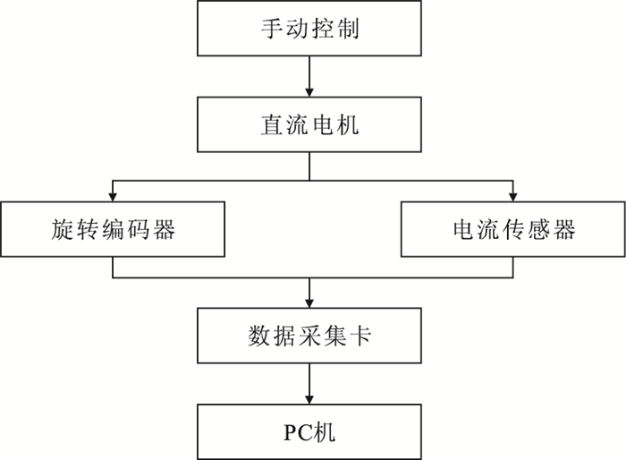
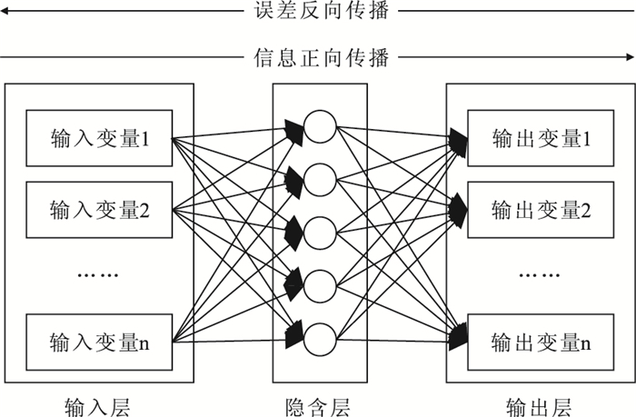
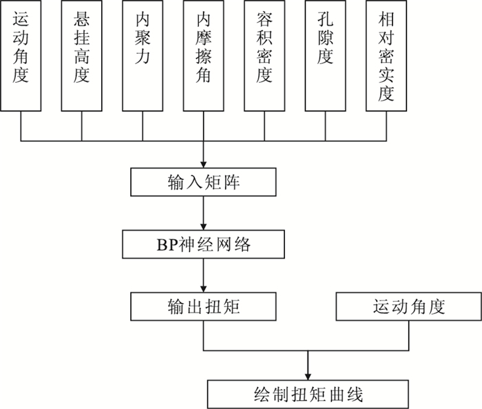
It is very important to start the lunar exploration for the sake of the buildup of comprehensive strength of China. According to a national plan, the main task of Chang'E-3 probe is to sample on the moon and return to the earth. At present, the researches on sampling tools are focused on the designing and simulating the drilling tool and there is little research on the surface sampling tools. A simulated lunar surface sampling tool, which is driven by a DC motor and could measure the torque during the experiments by using the current sensor, is designed for the experiments. Based on six types of lunar soil simulant and parameters, the experimental data shows that the change tendency of the tool torque under different conditions is nearly the same, and the torque curve could be described by four-feature points, whose values change with the different experiments parameters. All normalized data is imported to the BP neural network for learning and training in order to establish the model. The input parameters are divided into three types, including motion parameters (angle and hanging height), type parameters (cohesion and internal friction angle), and dense parameters (density, porosity and relative denseness) and the output parameter is the torque. By comparing the measured data and the output data of the model, it shows that accuracy in both fitting and predicting of the BP neural network is extremely high.
It is very important to start the lunar exploration for the sake of the buildup of comprehensive strength of China. According to a national plan, the main task of Chang'E-3 probe is to sample on the moon and return to the earth. At present, the researches on sampling tools are focused on the designing and simulating the drilling tool and there is little research on the surface sampling tools. A simulated lunar surface sampling tool, which is driven by a DC motor and could measure the torque during the experiments by using the current sensor, is designed for the experiments. Based on six types of lunar soil simulant and parameters, the experimental data shows that the change tendency of the tool torque under different conditions is nearly the same, and the torque curve could be described by four-feature points, whose values change with the different experiments parameters. All normalized data is imported to the BP neural network for learning and training in order to establish the model. The input parameters are divided into three types, including motion parameters (angle and hanging height), type parameters (cohesion and internal friction angle), and dense parameters (density, porosity and relative denseness) and the output parameter is the torque. By comparing the measured data and the output data of the model, it shows that accuracy in both fitting and predicting of the BP neural network is extremely high.