


2014 Vol. 39, No. 12
Display Method:
 PDF 237KB
2014, 39(12): 1751-1762.
doi: 10.3799/dqkx.2014.159
Abstract:
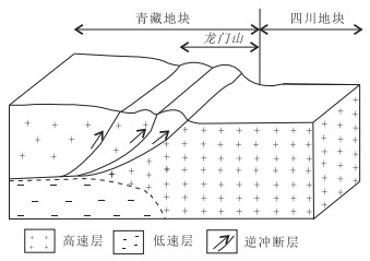
At 16:30 of August 3rd, 2014, an earthquake with a magnitude of Ms 6.5 occurred in Ludian County of Zhaotong City, Yunnan Province (27.1°N, 103.3°E). The depth of the hypocenter is 10 km. Due to this disaster, 617 people were died, 112 people disappeared and 108 840 000 people were injured. According to the superposition effects of the moon declination angle, sunspot extreme year cycles and the two, summed up 2013—2014 years is Yunnan strong earthquake periods of high risk, with the condition for the occurrence of Ms7 earthquake. The following year, forecast method based SW fingerprint information using the earthquake precursory instrument, developed by the end of 2014 211 earthquake prediction table, predict 2014 August Sichuan (26.18°N, 105.33°E) Ms5.3 earthquake will occur. The Ludian Ms 6.5 earthquake occurred on August 3, 2014 indicates that the error of the predicted date is only 1 day, the predicted epicenter is about 226 km away from the actual earthquake epicenter. Besides that the actual magnitude is Ms 1.2 larger than the predicted magnitude. According to the comprehensive analysis in tectonic setting, the S-wave crustal velocity structure and the focus mechanism of the Ludian earthquake, we believe that the Baogunao-Xiaohe left-lateral strike-slip fault triggered the Ludian earthquake, while the junction of the middle-low crust's low-velocity (high-conductivity) body and the Baogunao-Xiaohe fault is the location of the focus releasing the accumulated energy which practically is the epicenter.This provides a new case study of the three-level tectonic model for intraplate earthquakes.
At 16:30 of August 3rd, 2014, an earthquake with a magnitude of Ms 6.5 occurred in Ludian County of Zhaotong City, Yunnan Province (27.1°N, 103.3°E). The depth of the hypocenter is 10 km. Due to this disaster, 617 people were died, 112 people disappeared and 108 840 000 people were injured. According to the superposition effects of the moon declination angle, sunspot extreme year cycles and the two, summed up 2013—2014 years is Yunnan strong earthquake periods of high risk, with the condition for the occurrence of Ms7 earthquake. The following year, forecast method based SW fingerprint information using the earthquake precursory instrument, developed by the end of 2014 211 earthquake prediction table, predict 2014 August Sichuan (26.18°N, 105.33°E) Ms5.3 earthquake will occur. The Ludian Ms 6.5 earthquake occurred on August 3, 2014 indicates that the error of the predicted date is only 1 day, the predicted epicenter is about 226 km away from the actual earthquake epicenter. Besides that the actual magnitude is Ms 1.2 larger than the predicted magnitude. According to the comprehensive analysis in tectonic setting, the S-wave crustal velocity structure and the focus mechanism of the Ludian earthquake, we believe that the Baogunao-Xiaohe left-lateral strike-slip fault triggered the Ludian earthquake, while the junction of the middle-low crust's low-velocity (high-conductivity) body and the Baogunao-Xiaohe fault is the location of the focus releasing the accumulated energy which practically is the epicenter.This provides a new case study of the three-level tectonic model for intraplate earthquakes.


2014, 39(12): 1763-1775.
doi: 10.3799/dqkx.2014.160
Abstract:
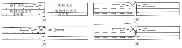
Triangular earthquake domain covering the Qinghai-Tibet Plateau and its adjacent areas is the most significant earthquake-prone area in the continent all overthe world. Stratiform distribution of hypocenters between 10 and 40 km can't be reasonably explained by brittle active faults and the elastic rebound model. To explore unknown seismogenic tectonics and earthquake mechanism, in this paper systematically is discussed the relationship of seismotectonic domain, seismotectonic layer, seismotectonic belt and seismotectonic point of the Qinghai-Tibet Plateau and its adjacent areas systematically is discussed based on the new understanding of continental dynamics and earth system dynamics. This paper elucidates the structural pattern of continental seismotectonic system: lower crustal ductile shear zone is the seismotectonic layer providing earthquake energy; middle crustal ductile-brittle shear zone is the hypocenter layer accumulating earthquake energy; and upper crustal brittle domain releases earthquake energy by faulting. Based on the study of seismotectonic system and tectonic settings upon the Qinghai-Tibet Plateau and its adjacent areas, in this paper further demonstrated the thermal fluid impacting mechanism is demonstrated asthenospheric laminar flow under the mid-ocean ridge driven by upwelling of the wall-like deep mantle magma transports mantle thermal energy and rheological material into continent where thickened asthenosphere diapirism results in incline of the Moho and inhomogeneous solid flow of lower continental crust from basin to mountain, the middle crustal ductile-brittle shear zone between ductile flowing lower crust and the brittle upper crust forms seismogenic layer by thermal energy-strain energy conversion. Hypocenter is located at the impacting point where abnormal flowing thermal fluid in lower crustal flow channel ("thermal river") impacts to the boundary between strong blocks (or layer) and weak blocks (or layer), and 5 different types of earthquakes are divided basen on different thermal tectonic environments and impacting angles. The new earthquake mechanism lays the theoretical foundation for scientific earthquake prediction.
Triangular earthquake domain covering the Qinghai-Tibet Plateau and its adjacent areas is the most significant earthquake-prone area in the continent all overthe world. Stratiform distribution of hypocenters between 10 and 40 km can't be reasonably explained by brittle active faults and the elastic rebound model. To explore unknown seismogenic tectonics and earthquake mechanism, in this paper systematically is discussed the relationship of seismotectonic domain, seismotectonic layer, seismotectonic belt and seismotectonic point of the Qinghai-Tibet Plateau and its adjacent areas systematically is discussed based on the new understanding of continental dynamics and earth system dynamics. This paper elucidates the structural pattern of continental seismotectonic system: lower crustal ductile shear zone is the seismotectonic layer providing earthquake energy; middle crustal ductile-brittle shear zone is the hypocenter layer accumulating earthquake energy; and upper crustal brittle domain releases earthquake energy by faulting. Based on the study of seismotectonic system and tectonic settings upon the Qinghai-Tibet Plateau and its adjacent areas, in this paper further demonstrated the thermal fluid impacting mechanism is demonstrated asthenospheric laminar flow under the mid-ocean ridge driven by upwelling of the wall-like deep mantle magma transports mantle thermal energy and rheological material into continent where thickened asthenosphere diapirism results in incline of the Moho and inhomogeneous solid flow of lower continental crust from basin to mountain, the middle crustal ductile-brittle shear zone between ductile flowing lower crust and the brittle upper crust forms seismogenic layer by thermal energy-strain energy conversion. Hypocenter is located at the impacting point where abnormal flowing thermal fluid in lower crustal flow channel ("thermal river") impacts to the boundary between strong blocks (or layer) and weak blocks (or layer), and 5 different types of earthquakes are divided basen on different thermal tectonic environments and impacting angles. The new earthquake mechanism lays the theoretical foundation for scientific earthquake prediction.


2014, 39(12): 1776-1782.
doi: 10.3799/dqkx.2014.161
Abstract:
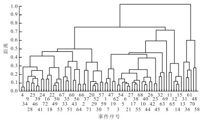
Earthquakes induced by water injection appeared in the border area of Changning, Xingwen and Gongxian counties, Sichuan Province since April, 2006. Up to April 30, 2013, 16 ML≥4.0 earthquakes occurred and the maximum is ML=5.2 on April 25, 2013. In this paper, the earthquake focal mechanism changing process of Changning ML≥3.0 earthquake sequence is studied by calculating correlation coefficient of body wave spectral amplitudes, and the results show that focal mechanisms of sequence events are scattering, furthermore, 12 ML≥4.0 earthquakes' focal mechanisms are calculated by CAP method and they are in disorder also. The following analyses believe that water injection causes the pore pressure of rock body increasing as well as the friction coefficients of pre-existing fault planes decreasing, and those 2 factors lead to Coulomb stress change Δσf increasing, thus induce earthquakes' occurrence. Therefore, the earthquakes induced by water injection occur without obvious enhancement of regional tectonic stress intensity, and there are no obvious restraining effects on the rupture directions of the earthquakes. As a result, the focal mechanisms of those earthquakes appear scattering.
Earthquakes induced by water injection appeared in the border area of Changning, Xingwen and Gongxian counties, Sichuan Province since April, 2006. Up to April 30, 2013, 16 ML≥4.0 earthquakes occurred and the maximum is ML=5.2 on April 25, 2013. In this paper, the earthquake focal mechanism changing process of Changning ML≥3.0 earthquake sequence is studied by calculating correlation coefficient of body wave spectral amplitudes, and the results show that focal mechanisms of sequence events are scattering, furthermore, 12 ML≥4.0 earthquakes' focal mechanisms are calculated by CAP method and they are in disorder also. The following analyses believe that water injection causes the pore pressure of rock body increasing as well as the friction coefficients of pre-existing fault planes decreasing, and those 2 factors lead to Coulomb stress change Δσf increasing, thus induce earthquakes' occurrence. Therefore, the earthquakes induced by water injection occur without obvious enhancement of regional tectonic stress intensity, and there are no obvious restraining effects on the rupture directions of the earthquakes. As a result, the focal mechanisms of those earthquakes appear scattering.


2014, 39(12): 1783-1792.
doi: 10.3799/dqkx.2014.162
Abstract:
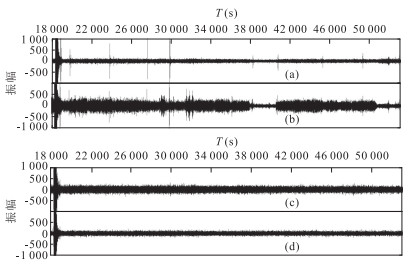
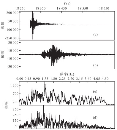
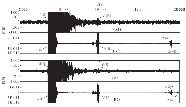
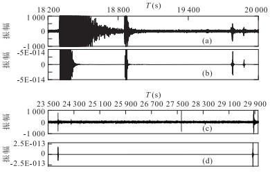
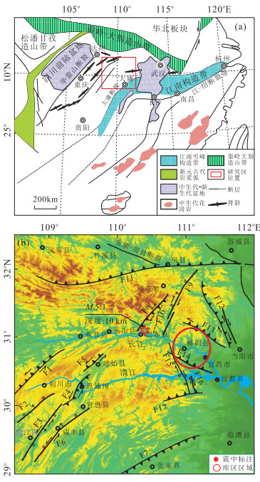
In order to resolve the long-time forward modeling instability and realize the long-time numerical simulation of natural seismic wave field, based on staggered-grid high-order difference method, the 2-D model partitioning way of M-PML is provided, the value of the M-PML absorbing boundary conversion coefficient P and its influence on the absorption capacity and the influence on effective signal made by truncation error are discussed, the 2D elastic wave long time numerical simulation using higher-order finite difference is realized. In addition, combining the data of the 5.5 magnitude earthquake which occurred in Hubei Badong on December 16, 2013 and its aftershock recorded by Wuhan and Zigui Seismograph Stations, the practical significance of the forward modeling method is verified. The results can provide a basis for the research of the propagation law, imaging, phase identification and hypocentral location of natural seismic wave field.
In order to resolve the long-time forward modeling instability and realize the long-time numerical simulation of natural seismic wave field, based on staggered-grid high-order difference method, the 2-D model partitioning way of M-PML is provided, the value of the M-PML absorbing boundary conversion coefficient P and its influence on the absorption capacity and the influence on effective signal made by truncation error are discussed, the 2D elastic wave long time numerical simulation using higher-order finite difference is realized. In addition, combining the data of the 5.5 magnitude earthquake which occurred in Hubei Badong on December 16, 2013 and its aftershock recorded by Wuhan and Zigui Seismograph Stations, the practical significance of the forward modeling method is verified. The results can provide a basis for the research of the propagation law, imaging, phase identification and hypocentral location of natural seismic wave field.


2014, 39(12): 1793-1806.
doi: 10.3799/dqkx.2014.163
Abstract:
On 16 December, 2013, an earthquake of Ms5.1 occurred in the Badong County, the Three Gorges reservoir area, China. Using the EIGEN-6C2 model, the satellite 8-638 order gravity anomalies in this area were studied. The results show that there is a regional low gravity anomaly beneath Badong area at 10 km, which may imply that rock density this area of is lower than its surroundings. Meanwhile, the profiles of crustal velocity structure of this area indicate the existence of two low-velocity layers at depth of 5-9 km and 10-15 km respectively. We believe that the upper layer is closely related to the reservoir seepage and the lower layer may result from the upwelling of the mantle hydrothermal fluid. The low-density layer and the two low-velocity layers provide an evidence for the existence of a possible ductile layer. The occurrence of Badong earthquake is due to the long-term energy accumulation and abrupt release at the deep crust, thus it is a tectonic earthquake. The low-velocity anomaly in the upper crust caused by reservoir seepage decreased the threshold value of fault activities and the change of water load of this reservoir might trigger the Badong earthquake. By comparing the infrasound with seismic waves, we conclude that the infrasound anomalies recorded by the infrasound monitor array are local infrasound.
On 16 December, 2013, an earthquake of Ms5.1 occurred in the Badong County, the Three Gorges reservoir area, China. Using the EIGEN-6C2 model, the satellite 8-638 order gravity anomalies in this area were studied. The results show that there is a regional low gravity anomaly beneath Badong area at 10 km, which may imply that rock density this area of is lower than its surroundings. Meanwhile, the profiles of crustal velocity structure of this area indicate the existence of two low-velocity layers at depth of 5-9 km and 10-15 km respectively. We believe that the upper layer is closely related to the reservoir seepage and the lower layer may result from the upwelling of the mantle hydrothermal fluid. The low-density layer and the two low-velocity layers provide an evidence for the existence of a possible ductile layer. The occurrence of Badong earthquake is due to the long-term energy accumulation and abrupt release at the deep crust, thus it is a tectonic earthquake. The low-velocity anomaly in the upper crust caused by reservoir seepage decreased the threshold value of fault activities and the change of water load of this reservoir might trigger the Badong earthquake. By comparing the infrasound with seismic waves, we conclude that the infrasound anomalies recorded by the infrasound monitor array are local infrasound.


2014, 39(12): 1807-1817.
doi: 10.3799/dqkx.2014.164
Abstract:
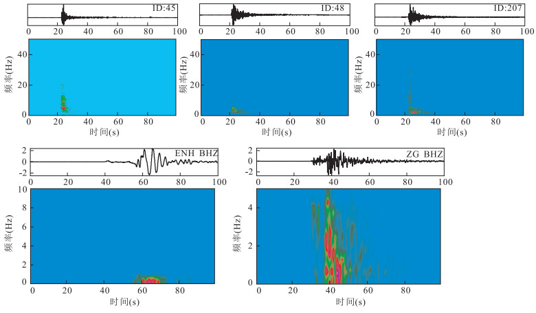
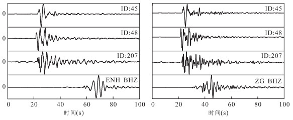
A kind of least-square-error localization algorithm applied on wide spread infrasound network is proposed in this article. Models of cross correlation between distant sensors and atmosphere infrasound propagation are analyzed. The localization error caused by quantity and distribution structure of network and ray tracing of local infrasound in real atmosphere are also calculated. Infrasound coupled by local seismic Rayleigh wave of Lushan (Ya'an) earthquake on April 20th, 2013 is detected by infrasound network and could prove the algorithm and analysis above. Comparing infrasound signals with seismic recording of IRIS global network, we find that they ware well correlated for the corresponding time period in signal travel time, signal correlation (0.6-0.9), particle motion trajectory analysis, etc.. The zone of infrasound source calculated by the least-square-error localizing algorithm is not compact but its center (minimum value determined by least-square-error method) is less than 150 km distant from the epicenter. Due to the less absorption and refraction in atmosphere propagation, local infrasound is easily detected and recognized and could be a possible and feasible way to monitor earthquake and relationship between ground motion and pressure perturbation in atmosphere.
A kind of least-square-error localization algorithm applied on wide spread infrasound network is proposed in this article. Models of cross correlation between distant sensors and atmosphere infrasound propagation are analyzed. The localization error caused by quantity and distribution structure of network and ray tracing of local infrasound in real atmosphere are also calculated. Infrasound coupled by local seismic Rayleigh wave of Lushan (Ya'an) earthquake on April 20th, 2013 is detected by infrasound network and could prove the algorithm and analysis above. Comparing infrasound signals with seismic recording of IRIS global network, we find that they ware well correlated for the corresponding time period in signal travel time, signal correlation (0.6-0.9), particle motion trajectory analysis, etc.. The zone of infrasound source calculated by the least-square-error localizing algorithm is not compact but its center (minimum value determined by least-square-error method) is less than 150 km distant from the epicenter. Due to the less absorption and refraction in atmosphere propagation, local infrasound is easily detected and recognized and could be a possible and feasible way to monitor earthquake and relationship between ground motion and pressure perturbation in atmosphere.


2014, 39(12): 1818-1830.
doi: 10.3799/dqkx.2014.165
Abstract:
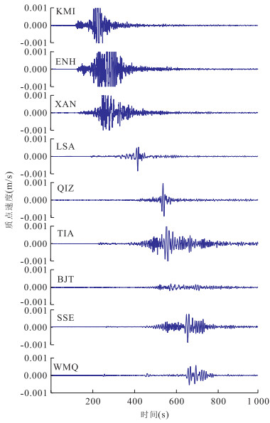
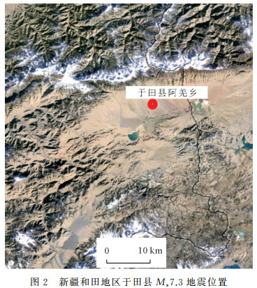
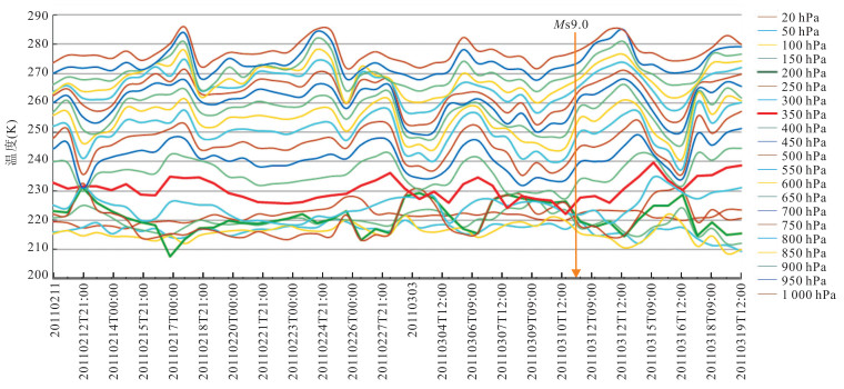
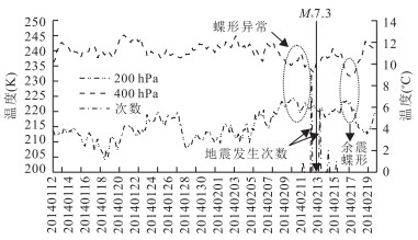
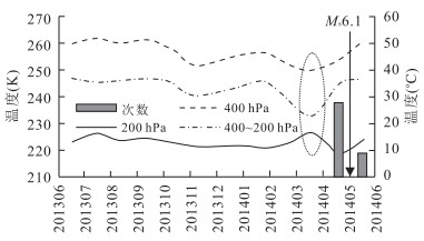
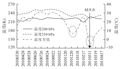
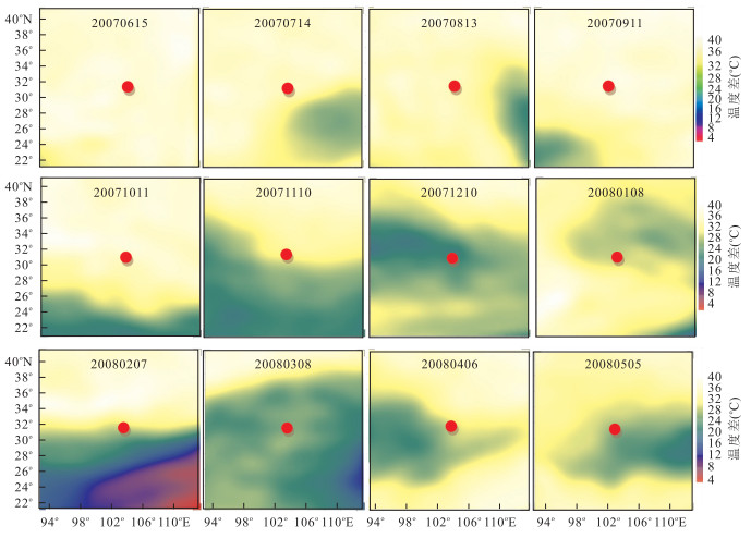
Air temperature variation over the epicenter before terrestrial and marine earthquakes is analyzed and its possibility being applied in short-term and impending earthquake prediction is examined. The data obtained from the National Oceanic and Atmospheric Administration (NOAA) in different height scales with hPa unit are analyzed. Earthquake samples include the earthquakes in Yutian (Ms7.3, February 12th, 2014), Wenchuan (Ms 8.0, May 12th, 2008), Japan (Ms9.0, March 11th, 2011), Chile marine earthquake (Ms 8.0, April 1st, 2014), (Nantou Ms 6.1, March 27th, 2013), and Yingjiang (Ms 6.1, May 30th, 2014). The results show: (1) atmospheric temperature has more consistent trends at 300-1 000 hPa in the epicenter before earthquake; (2) the line charts of 200 hPa and 400 hPa temperature exhibit a graph with approaching and intersection (we can choose other height data such as 350 hPa, 300 hPa, etc. according to various locations) approaching earthquake occurring time. This special curve shape is similar to butterfly wings and be called as "butterfly pattern"; (3) the values of the air temperature difference between 200 hPa and 400 hPa are reduced in contour map near the epicenter area (a few months, weeks or several days before the earthquake). The lowest point of collapse in the contour map of air temperature difference corresponds to epicenter. The regularity is expected to be applied to predict on time and epicenter in short-term and impending earthquake.
Air temperature variation over the epicenter before terrestrial and marine earthquakes is analyzed and its possibility being applied in short-term and impending earthquake prediction is examined. The data obtained from the National Oceanic and Atmospheric Administration (NOAA) in different height scales with hPa unit are analyzed. Earthquake samples include the earthquakes in Yutian (Ms7.3, February 12th, 2014), Wenchuan (Ms 8.0, May 12th, 2008), Japan (Ms9.0, March 11th, 2011), Chile marine earthquake (Ms 8.0, April 1st, 2014), (Nantou Ms 6.1, March 27th, 2013), and Yingjiang (Ms 6.1, May 30th, 2014). The results show: (1) atmospheric temperature has more consistent trends at 300-1 000 hPa in the epicenter before earthquake; (2) the line charts of 200 hPa and 400 hPa temperature exhibit a graph with approaching and intersection (we can choose other height data such as 350 hPa, 300 hPa, etc. according to various locations) approaching earthquake occurring time. This special curve shape is similar to butterfly wings and be called as "butterfly pattern"; (3) the values of the air temperature difference between 200 hPa and 400 hPa are reduced in contour map near the epicenter area (a few months, weeks or several days before the earthquake). The lowest point of collapse in the contour map of air temperature difference corresponds to epicenter. The regularity is expected to be applied to predict on time and epicenter in short-term and impending earthquake.


2014, 39(12): 1831-1841.
doi: 10.3799/dqkx.2014.166
Abstract:
The latest model of the gravitational field was used in the analysis of the gravity anomaly characteristics in the Yutian seismic zone and surrounding regions. The layered crustal structure model (Crust1.0) has been applied to obtain the deep tectonic structure around the seismic zone. This epicenter occurred in the steep variations of the crustal thickness. Contrast to the Ms7.3 earthquake in 2008 in this region, although these two epicenter were located in different 3-D spaces, they are closely related to the changes in the deep crustal structures. Besides, based on the statistical analysis of the relationship between the seismicity of historical earthquakes (Ms≥5.0) and three different gravity anomalies, we found that the free-air gravity anomalies in the seismic zone are in an obvious linear correlation to the topography, while the Bouguer anomaly and isostatic anomaly are distinctly different with the topography. In addition, the total gorizontal gradient (HGM)of the anomalies were calculated and the analytical signal (ASL) was plotted, which suggest that the gradient values are more distinctly correlated. The results show that a significant statistical characteristic exists between the activities of the strong earthquakes (Ms≥7.0) and the gravity anomalies, which may be related to the mass uneven distribution of the deep structure which caused the gravity anomaly.
The latest model of the gravitational field was used in the analysis of the gravity anomaly characteristics in the Yutian seismic zone and surrounding regions. The layered crustal structure model (Crust1.0) has been applied to obtain the deep tectonic structure around the seismic zone. This epicenter occurred in the steep variations of the crustal thickness. Contrast to the Ms7.3 earthquake in 2008 in this region, although these two epicenter were located in different 3-D spaces, they are closely related to the changes in the deep crustal structures. Besides, based on the statistical analysis of the relationship between the seismicity of historical earthquakes (Ms≥5.0) and three different gravity anomalies, we found that the free-air gravity anomalies in the seismic zone are in an obvious linear correlation to the topography, while the Bouguer anomaly and isostatic anomaly are distinctly different with the topography. In addition, the total gorizontal gradient (HGM)of the anomalies were calculated and the analytical signal (ASL) was plotted, which suggest that the gradient values are more distinctly correlated. The results show that a significant statistical characteristic exists between the activities of the strong earthquakes (Ms≥7.0) and the gravity anomalies, which may be related to the mass uneven distribution of the deep structure which caused the gravity anomaly.


2014, 39(12): 1842-1850.
doi: 10.3799/dqkx.2014.167
Abstract:
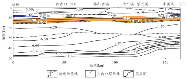
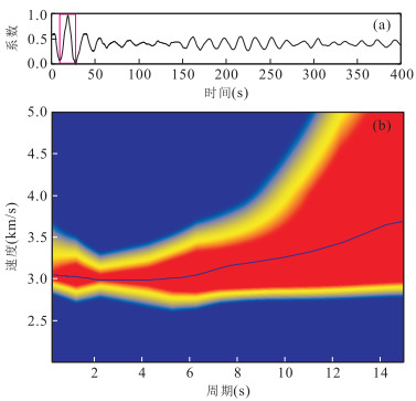
In order to make a better understanding of the stability of the Three Gorges Reservoir region, the profile of S-wave velocity structure along Badong-Maoping-Tumen is presented using the ambient noise data observed at 10 stations from mobile broadband seismic array which is located at Three Gorges Reservoir region. All of available vertical component time series during April and May, 2011 have been cross-correlated to estimate the empirical Green functions. Group velocity dispersion curves were measured by applying multiple filtering technique. Using these dispersion curves, we obtain high resolution pure-path dispersions at 0.5-10 s periods. The S-wave velocity structure, which was reconstructed by inverting the pure-path dispersions, reveals the velocity variations of upper crust at Three Gorges Reservoir region. Main conclusions are as follows. (1)The velocity variations in the study region have a close relationship with the geological structure and the velocity profile suggests an anticline unit which core area is Huangling block. (2)The relative fast velocity variations beneath Jiuwanxi and its surrounding areas may correspond to the geological structure and earthquake activity there. (3) The high velocity of the upper crust in Sandouping indicates that the reservoir dam of Three Gorges is located at a tectonic stable region.
In order to make a better understanding of the stability of the Three Gorges Reservoir region, the profile of S-wave velocity structure along Badong-Maoping-Tumen is presented using the ambient noise data observed at 10 stations from mobile broadband seismic array which is located at Three Gorges Reservoir region. All of available vertical component time series during April and May, 2011 have been cross-correlated to estimate the empirical Green functions. Group velocity dispersion curves were measured by applying multiple filtering technique. Using these dispersion curves, we obtain high resolution pure-path dispersions at 0.5-10 s periods. The S-wave velocity structure, which was reconstructed by inverting the pure-path dispersions, reveals the velocity variations of upper crust at Three Gorges Reservoir region. Main conclusions are as follows. (1)The velocity variations in the study region have a close relationship with the geological structure and the velocity profile suggests an anticline unit which core area is Huangling block. (2)The relative fast velocity variations beneath Jiuwanxi and its surrounding areas may correspond to the geological structure and earthquake activity there. (3) The high velocity of the upper crust in Sandouping indicates that the reservoir dam of Three Gorges is located at a tectonic stable region.


2014, 39(12): 1851-1856.
doi: 10.3799/dqkx.2014.168
Abstract:
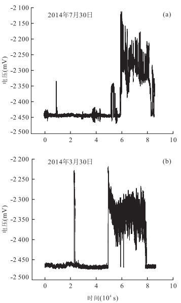
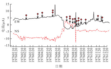
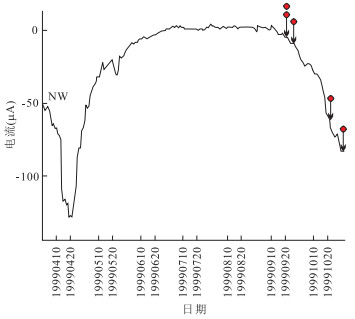
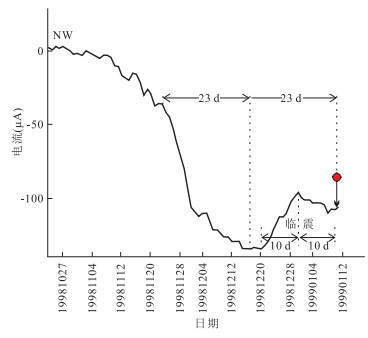
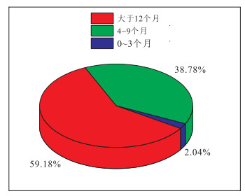
The geoelectric field data recorded for more than thirty years at seismostation in 625 Research Institute of Aviation Industry Corporation of China were analyzed, and eight sets of data including four sets of long-term abnormal signals and four sets of short-term abnormal signals were extracted. The abnormal short-term signals correspond to four Ms > 6.0 earthquakes. The geoelectric field signals have the following characteristics. (1) The long-term geoelectric field curves include precursory information from many earthquakes with different magnitudes and epicenter distances. The near-field and major earthquakes control the trendy of geoelectric field curves. Meanwhile big far earthquakes and small near earthquakes can cause oscillations up and down. (2) In the four short-term signals, we find that the geoelectric field curves show a common pattern of up(down), return, bound and occuring phases. The geoelectric field abnormal forms have similarity and repeatability. This proves that the geoelectric field observation can monitor the impending earthquake precursor. A new method to predict the occurrence-time is found. Based on the number of return days approximately be equal to the number of bound days, the date of occurrence time is the date of return plus the number of bound days. It pushes further the method of geoelectric field short-term earthquake precursor toward practice.
The geoelectric field data recorded for more than thirty years at seismostation in 625 Research Institute of Aviation Industry Corporation of China were analyzed, and eight sets of data including four sets of long-term abnormal signals and four sets of short-term abnormal signals were extracted. The abnormal short-term signals correspond to four Ms > 6.0 earthquakes. The geoelectric field signals have the following characteristics. (1) The long-term geoelectric field curves include precursory information from many earthquakes with different magnitudes and epicenter distances. The near-field and major earthquakes control the trendy of geoelectric field curves. Meanwhile big far earthquakes and small near earthquakes can cause oscillations up and down. (2) In the four short-term signals, we find that the geoelectric field curves show a common pattern of up(down), return, bound and occuring phases. The geoelectric field abnormal forms have similarity and repeatability. This proves that the geoelectric field observation can monitor the impending earthquake precursor. A new method to predict the occurrence-time is found. Based on the number of return days approximately be equal to the number of bound days, the date of occurrence time is the date of return plus the number of bound days. It pushes further the method of geoelectric field short-term earthquake precursor toward practice.


2014, 39(12): 1857-1863.
doi: 10.3799/dqkx.2014.169
Abstract:
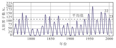
The relationship between solar activity and earthquake in the world was studied by applying a dimensionless function of seismic energy √G to investigate the energy release time series of global large earthquakes (M≥7.0) occurred during the year of 1681—2011. From the study, we find that the distribution and activity of global large earthquake in 4 phases of solar cycle varied with magnitude. We suggest that it can be explained by a model of load-unload response of the earth crustal movement to solar storm. The findings of spatial and temporal distribution characteristics of 10 M≥9.0 super earthquakes in past years of 331 in the world and absence of super earthquake in solar maximum. The results are helpful to predict occurrence of future global large earthquake as reference.
The relationship between solar activity and earthquake in the world was studied by applying a dimensionless function of seismic energy √G to investigate the energy release time series of global large earthquakes (M≥7.0) occurred during the year of 1681—2011. From the study, we find that the distribution and activity of global large earthquake in 4 phases of solar cycle varied with magnitude. We suggest that it can be explained by a model of load-unload response of the earth crustal movement to solar storm. The findings of spatial and temporal distribution characteristics of 10 M≥9.0 super earthquakes in past years of 331 in the world and absence of super earthquake in solar maximum. The results are helpful to predict occurrence of future global large earthquake as reference.


2014, 39(12): 1864-1872.
doi: 10.3799/dqkx.2014.170
Abstract:
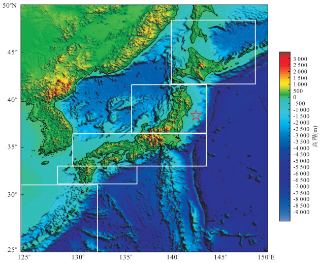
We quoted total 67 seismic events of Ms=6.9-9.0 in past 110 years (during 1900 to March 2011) in five divided regions from north to south in Japan and total 569 moderate-strong earthquakes of Ms≥6.0 in China and its vicinity to study their correlativity. The corresponding comparison was carried out to compare each Japanese earthquake and earthquakes occurred in China and its vicinity within 4 years (predominantly, Ms≥6.0). It is found that there are good correlations between great earthquakes in Japan and moderate-strong earthquakes in China and its vicinity. By studying the correlation characteristics, there are lag intervals, mostly from 6 months to 2 years but no more than 4 years, when earthquakes occurred in China after earthquakes in Japan. The "teleconnection prediction method" to predict the moderate-strong seismic risk regions in China and its vicinity is applied and positive results of 82% correctness (6 false predictions in 34 earthquake regions) are obtained. We try to use a "spider web" model of reverse reaction to explain the correlativity of earthquakes which we studied.
We quoted total 67 seismic events of Ms=6.9-9.0 in past 110 years (during 1900 to March 2011) in five divided regions from north to south in Japan and total 569 moderate-strong earthquakes of Ms≥6.0 in China and its vicinity to study their correlativity. The corresponding comparison was carried out to compare each Japanese earthquake and earthquakes occurred in China and its vicinity within 4 years (predominantly, Ms≥6.0). It is found that there are good correlations between great earthquakes in Japan and moderate-strong earthquakes in China and its vicinity. By studying the correlation characteristics, there are lag intervals, mostly from 6 months to 2 years but no more than 4 years, when earthquakes occurred in China after earthquakes in Japan. The "teleconnection prediction method" to predict the moderate-strong seismic risk regions in China and its vicinity is applied and positive results of 82% correctness (6 false predictions in 34 earthquake regions) are obtained. We try to use a "spider web" model of reverse reaction to explain the correlativity of earthquakes which we studied.


2014, 39(12): 1873-1879.
doi: 10.3799/dqkx.2014.171
Abstract:
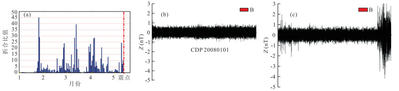
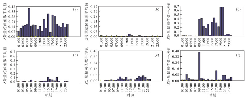
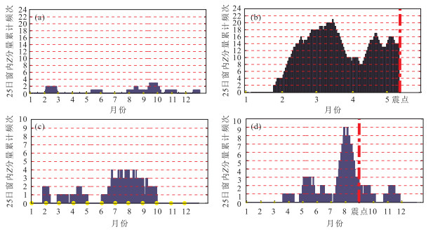
According to the result of geomagnetic data, great abnormal magnetic phenomenon occurring repeatedly before some significant earthquakes were found. This kind of phenomenon occurs about from over forty to a hundred days before. This pre-seismic geomagnetic anomaly lasts long as the magnitude increases. The nature of geomagnetic data before earthquakes has something to do with earthquake prediction and may be applied to precaution against earthquake disasters.
According to the result of geomagnetic data, great abnormal magnetic phenomenon occurring repeatedly before some significant earthquakes were found. This kind of phenomenon occurs about from over forty to a hundred days before. This pre-seismic geomagnetic anomaly lasts long as the magnitude increases. The nature of geomagnetic data before earthquakes has something to do with earthquake prediction and may be applied to precaution against earthquake disasters.


2014, 39(12): 1880-1886.
doi: 10.3799/dqkx.2014.172
Abstract:
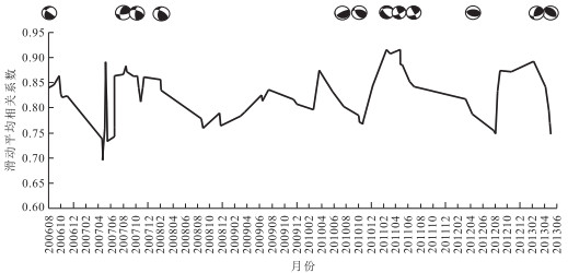
In Yunnan, earthquakes happened frequently, as well as groundwater temperature observation points are mostly centralized for its distribution. It is comprehensively collected for seismic cases on water temperature anomaly before the reform, the relationships of seism with water temperature anomaly duration and abnormal space is researched systematically. The result shows that water temperature anomaly is mainly impending-earthquake anomalies, however it has mid-term tendency anomalies before strong earthquakes. Generally, the greater earthquake magnitude, the vaster anomaly range, earthquakes were occurred during anomaly concentration area. The studying achievement has great significance for earthquake prediction and station setting.
In Yunnan, earthquakes happened frequently, as well as groundwater temperature observation points are mostly centralized for its distribution. It is comprehensively collected for seismic cases on water temperature anomaly before the reform, the relationships of seism with water temperature anomaly duration and abnormal space is researched systematically. The result shows that water temperature anomaly is mainly impending-earthquake anomalies, however it has mid-term tendency anomalies before strong earthquakes. Generally, the greater earthquake magnitude, the vaster anomaly range, earthquakes were occurred during anomaly concentration area. The studying achievement has great significance for earthquake prediction and station setting.


2014, 39(12): 1887-1895.
doi: 10.3799/dqkx.2014.173
Abstract:
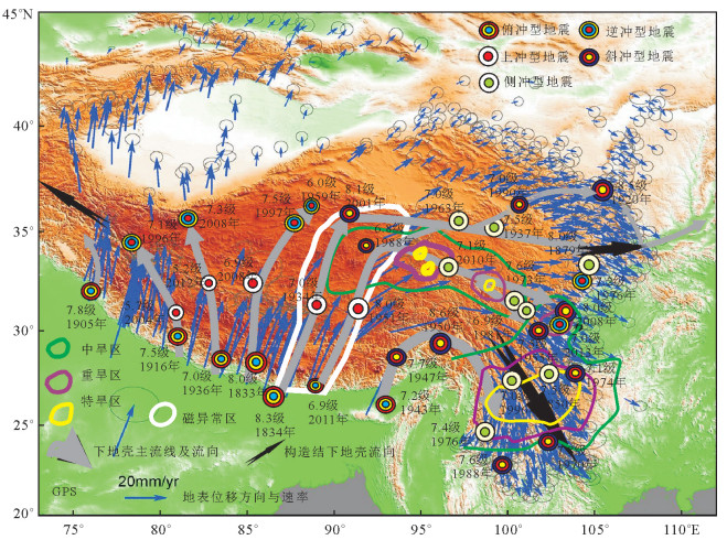
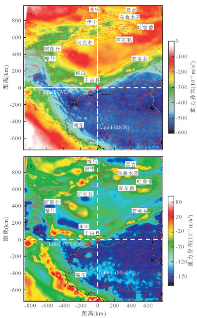
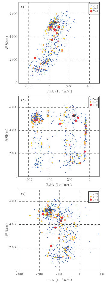
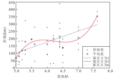
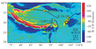
In order to find the relationship among a large (Ms≥7) earthquake, or a giant earthquake (Ms≥8) and the steepest gradient of gravity field and active fault, the free air gravity anomaly map by EIGEN-6C gravity model was calculated, the bouguer gravity anomaly and active fault of the region trends to occur large or giant earthquake is consulted. The spatial distribution of large and giant earthquakes and active fault, gravity anomaly is analyzed. We come to a conclusion that a large or giant earthquake trends to occur at the intersection area of steepest gradient of gravity field and active fault. With the previous study of deep structures in those area, we propose a rheological model to interpret the regularity. It is that the flow of the rheological layer (body) blocked by the brittle rocks cause the gravity anomaly and energy accumulation and release.
In order to find the relationship among a large (Ms≥7) earthquake, or a giant earthquake (Ms≥8) and the steepest gradient of gravity field and active fault, the free air gravity anomaly map by EIGEN-6C gravity model was calculated, the bouguer gravity anomaly and active fault of the region trends to occur large or giant earthquake is consulted. The spatial distribution of large and giant earthquakes and active fault, gravity anomaly is analyzed. We come to a conclusion that a large or giant earthquake trends to occur at the intersection area of steepest gradient of gravity field and active fault. With the previous study of deep structures in those area, we propose a rheological model to interpret the regularity. It is that the flow of the rheological layer (body) blocked by the brittle rocks cause the gravity anomaly and energy accumulation and release.


2014, 39(12): 1896-1902.
doi: 10.3799/dqkx.2014.174
Abstract:
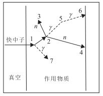
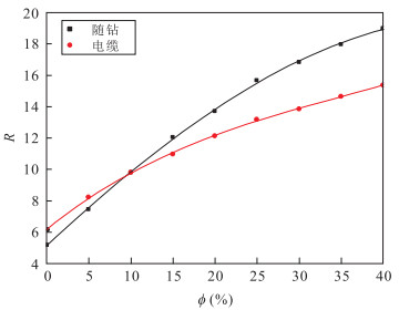
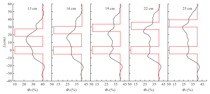
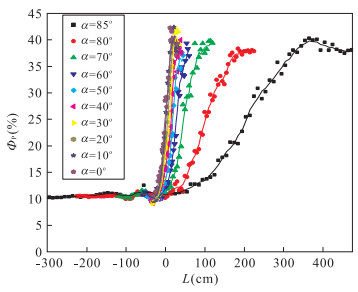
Neutron porosity logging while drilling (LWD) plays an important role in formation evaluation under LWD environment, so it has a great significance to study the logging response characteristic. Monte Carlo method is employed to build formation modeling under LWD conditions, and the response characteristic is simulated. The results reveal that the changing trend of porosity response of neutron logging while drilling is similar to that of wireline under the same conditions, the sensitivity of porosity curve in LWD to porosity is higher than wireline, but the neutron porosity logging response of LWD is affected severely by the drilling collar. The depth of investigation is related to formation porosity, and the depth of investigation and vertical resolution under the conditions in this paper is 28 cm and 19 cm, respectively. In high angle and horizontal wells, the effect of measurement azimuth on neutron porosity curve is slight. When the relative dip α is low, the midpoint of transition area of neutron porosity curve is close to the boundary surface. If α is less than 60°, the effect of the adjacent formation on porosity curve can be ignored.
Neutron porosity logging while drilling (LWD) plays an important role in formation evaluation under LWD environment, so it has a great significance to study the logging response characteristic. Monte Carlo method is employed to build formation modeling under LWD conditions, and the response characteristic is simulated. The results reveal that the changing trend of porosity response of neutron logging while drilling is similar to that of wireline under the same conditions, the sensitivity of porosity curve in LWD to porosity is higher than wireline, but the neutron porosity logging response of LWD is affected severely by the drilling collar. The depth of investigation is related to formation porosity, and the depth of investigation and vertical resolution under the conditions in this paper is 28 cm and 19 cm, respectively. In high angle and horizontal wells, the effect of measurement azimuth on neutron porosity curve is slight. When the relative dip α is low, the midpoint of transition area of neutron porosity curve is close to the boundary surface. If α is less than 60°, the effect of the adjacent formation on porosity curve can be ignored.


2014, 39(12): 1903-1914.
doi: 10.3799/dqkx.2014.175
Abstract:
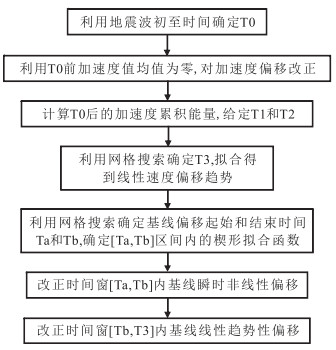
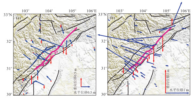
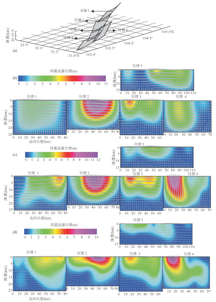
Based on the near-field strong-motion records, the distribution of peak acceleration near the Wenchuan Ms8.0 earthquake exists obvious hanging wall and directivity effect, it is consistent with the distribution of geological hazard caused by Wenchuan earthquake. However, among the crustal co-seismic velocities which are achieved by integrating the acceleration of Wenchuan Ms8.0 earthquake recorded by strong motion seismograph, there is a typical linear offset for some stations, and there are also obvious nonlinear offsets besides linear offset for some other stations. Using the approach of nonlinear baseline correction to process co-seismic records of Wenchuan Ms8.0 earthquake, the co-seismic displacement corrected by the nonlinear approach obviously is in better agreement with actual situation than the linear baseline correction approach. As a constraint of displacement processing results of strong-motion, GPS and InSAR, this paper inverts the distribution of co-seismic dislocation of Wenchuan Ms8.0 earthquake. For the main co-seismic rupture fault of Wenchuan Ms8.0 earthquake (Beichuan-Yingxiu fault), the inversion result of strong-motion is not only nicely characterize the detailed variation of distribution of co-seismic surface rupture on the main fault, but also well reflect the rupture attenuation on northernmost fault. The results show that, strong-motion data could provide valuable results for post-seismic rescue and disaster assessment. In addition, due to data limitations, for the location distribution which inverted from displacement corrected by strong motion, only the southern section of Hanwang fault exists obvious dislocation. It reveals that we should emplace the strong motion seismographs relatively uniform around the potential seismogenic faults, in order to play a better role in the post-seismic emergency rescue.
Based on the near-field strong-motion records, the distribution of peak acceleration near the Wenchuan Ms8.0 earthquake exists obvious hanging wall and directivity effect, it is consistent with the distribution of geological hazard caused by Wenchuan earthquake. However, among the crustal co-seismic velocities which are achieved by integrating the acceleration of Wenchuan Ms8.0 earthquake recorded by strong motion seismograph, there is a typical linear offset for some stations, and there are also obvious nonlinear offsets besides linear offset for some other stations. Using the approach of nonlinear baseline correction to process co-seismic records of Wenchuan Ms8.0 earthquake, the co-seismic displacement corrected by the nonlinear approach obviously is in better agreement with actual situation than the linear baseline correction approach. As a constraint of displacement processing results of strong-motion, GPS and InSAR, this paper inverts the distribution of co-seismic dislocation of Wenchuan Ms8.0 earthquake. For the main co-seismic rupture fault of Wenchuan Ms8.0 earthquake (Beichuan-Yingxiu fault), the inversion result of strong-motion is not only nicely characterize the detailed variation of distribution of co-seismic surface rupture on the main fault, but also well reflect the rupture attenuation on northernmost fault. The results show that, strong-motion data could provide valuable results for post-seismic rescue and disaster assessment. In addition, due to data limitations, for the location distribution which inverted from displacement corrected by strong motion, only the southern section of Hanwang fault exists obvious dislocation. It reveals that we should emplace the strong motion seismographs relatively uniform around the potential seismogenic faults, in order to play a better role in the post-seismic emergency rescue.


2014, 39(12): 1915-1926.
doi: 10.3799/dqkx.2014.176
Abstract:
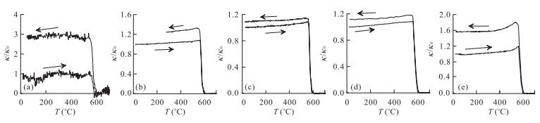
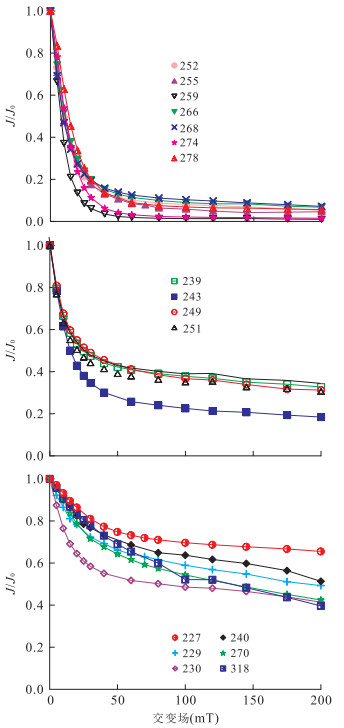
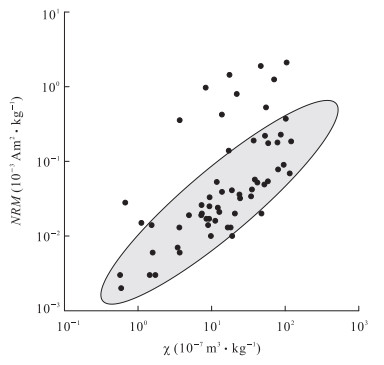
Detailed magnetic studies and mineralogy analysis show that the granitic gneiss has the second highest (only second to the serpentinized garnet peridotite) low-field susceptibility (χ) (0.570×10⁻⁷-120.450×10⁻⁷m3·kg-1, average 29.996×10⁻⁷m3·kg-1) and the lowest natural remanent magnetization (NRM) (0.002×10⁻³-2.109×10⁻³Am2·kg-1, average 0.210×10⁻³Am2·kg-1). Temperature dependence of magnetic susceptibility, alternating field (AF) demagnetization and magnetic hysteresis properties suggest that the magnetic minerals in granitic gneiss are magnetite ± hematite, the magnetites are mainly multi-domain (MD), pseudo-single domain (PSD) magnetites are also presented in small amounts. The grain size of magnetites are obviously larger than that in the completely retrograded eclogites, which have the same magnetic mineral assemblage and experienced amphibolite facies retrograde metamorphism. The formation of MD magnetites are thought to be related with stronger fluid activities during the retrogression. Samples occurring out of the major gneiss subunit and adjacent to the eclogites, which have related high NRM, may reflect fluid movements between felsic and mafic UHPM rocks.
Detailed magnetic studies and mineralogy analysis show that the granitic gneiss has the second highest (only second to the serpentinized garnet peridotite) low-field susceptibility (χ) (0.570×10⁻⁷-120.450×10⁻⁷m3·kg-1, average 29.996×10⁻⁷m3·kg-1) and the lowest natural remanent magnetization (NRM) (0.002×10⁻³-2.109×10⁻³Am2·kg-1, average 0.210×10⁻³Am2·kg-1). Temperature dependence of magnetic susceptibility, alternating field (AF) demagnetization and magnetic hysteresis properties suggest that the magnetic minerals in granitic gneiss are magnetite ± hematite, the magnetites are mainly multi-domain (MD), pseudo-single domain (PSD) magnetites are also presented in small amounts. The grain size of magnetites are obviously larger than that in the completely retrograded eclogites, which have the same magnetic mineral assemblage and experienced amphibolite facies retrograde metamorphism. The formation of MD magnetites are thought to be related with stronger fluid activities during the retrogression. Samples occurring out of the major gneiss subunit and adjacent to the eclogites, which have related high NRM, may reflect fluid movements between felsic and mafic UHPM rocks.


2014, 39(12): 1927-1932.
doi: 10.3799/dqkx.2014.177
Abstract:
Mongolia is an important neighbor of northern China. Western Mongolia ancient tectonic is a major structure in north of north-south tectonic earthquake zone, one important earthquake zone in China. In this paper, surfaces spline (SP) method is used to calculate the geomagnetic data on 119 sites in Mongolia on 2010.0 epoch, and the geomagnetic spatial structure in Mongolia is obtained. The results show that the geomagnetic spatial distribution of magnetic components given by SP model and EMM is similar, but there are some differences in part. These differences can reach ±30' for I, ± 60' for D and ± 500 nT for H, F, X, Y, Z.
Mongolia is an important neighbor of northern China. Western Mongolia ancient tectonic is a major structure in north of north-south tectonic earthquake zone, one important earthquake zone in China. In this paper, surfaces spline (SP) method is used to calculate the geomagnetic data on 119 sites in Mongolia on 2010.0 epoch, and the geomagnetic spatial structure in Mongolia is obtained. The results show that the geomagnetic spatial distribution of magnetic components given by SP model and EMM is similar, but there are some differences in part. These differences can reach ±30' for I, ± 60' for D and ± 500 nT for H, F, X, Y, Z.


