2014 Vol. 39, No. 9
Display Method:
 PDF 1720KB
2014, 39(9): 1243-1257.
doi: 10.3799/dqkx.2014.107
Abstract:
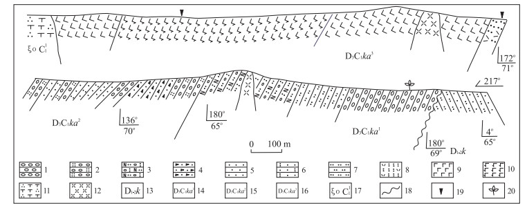
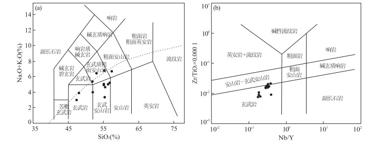
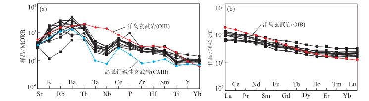
A set of volcanic sedimentary formation outcrops in Wucaiwan, Karamaili area, eastern Junggar, composed of conglomerate, sandstone characterized by molasse in its lower part, and intermediate-basic lava interbedded with intermediate-acidic tuff in its upper part. The volcanic sedimentary formation is categorized into the Lower Carboniferous Songkaersu Formation in 1:200 000 Karamaili Mountain report. The 1:50 000 geological survey finds that a set of coarse conglomerate in the bottom high angle unconformably overlies the Early-Middle Devonian Karamaili Formation and contains plant fossil Prelepidodendron sp. of Late Devonian to Early Carboniferous. The volcanic rocks in the middle-upper part are intruded by post-collision granite of 341.1±4.0 Ma to 340.9±5.1 Ma, and its zircon U-Pb age is 346.8±3.3 Ma obtained by LA-ICP-MS. It indicates that the age of the volcanic sedimentary formation is Late Devonian-Early Carboniferous which might correspond to the Upper Devonian Keankuduke Formation in northern Junggar stratigraphic group. The volcanic rocks consist of basalt, basaltic andesite, and a handful of rhyolitic tuff, belonging to calc-alkaline and high K calc-alkaline series; and they are enriched in LILE and LREE ((La/Yb)N=2.97-6.66), depleted slightly in Nb, Ta, and depleted weakly in Zr, Ti in some samples, with Nb/U=7.43-20.88, Ce/Pb=3.17-12.45. These volcanic rocks show both intraplate and arc volcanic rock geochemistry characteristics, formed in post-collision extensional period after the closure of Karamaili Ocean before the Upper Devonian. This study determines the final amalgamation time of Karamali Ocean, an issue of wide concern.
A set of volcanic sedimentary formation outcrops in Wucaiwan, Karamaili area, eastern Junggar, composed of conglomerate, sandstone characterized by molasse in its lower part, and intermediate-basic lava interbedded with intermediate-acidic tuff in its upper part. The volcanic sedimentary formation is categorized into the Lower Carboniferous Songkaersu Formation in 1:200 000 Karamaili Mountain report. The 1:50 000 geological survey finds that a set of coarse conglomerate in the bottom high angle unconformably overlies the Early-Middle Devonian Karamaili Formation and contains plant fossil Prelepidodendron sp. of Late Devonian to Early Carboniferous. The volcanic rocks in the middle-upper part are intruded by post-collision granite of 341.1±4.0 Ma to 340.9±5.1 Ma, and its zircon U-Pb age is 346.8±3.3 Ma obtained by LA-ICP-MS. It indicates that the age of the volcanic sedimentary formation is Late Devonian-Early Carboniferous which might correspond to the Upper Devonian Keankuduke Formation in northern Junggar stratigraphic group. The volcanic rocks consist of basalt, basaltic andesite, and a handful of rhyolitic tuff, belonging to calc-alkaline and high K calc-alkaline series; and they are enriched in LILE and LREE ((La/Yb)N=2.97-6.66), depleted slightly in Nb, Ta, and depleted weakly in Zr, Ti in some samples, with Nb/U=7.43-20.88, Ce/Pb=3.17-12.45. These volcanic rocks show both intraplate and arc volcanic rock geochemistry characteristics, formed in post-collision extensional period after the closure of Karamaili Ocean before the Upper Devonian. This study determines the final amalgamation time of Karamali Ocean, an issue of wide concern.


2014, 39(9): 1258-1276.
doi: 10.3799/dqkx.2014.108
Abstract:
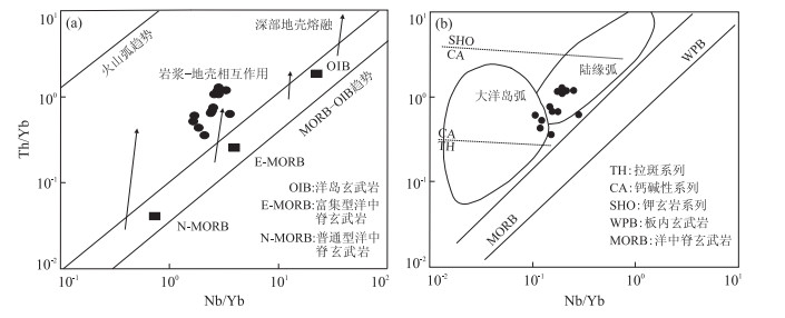
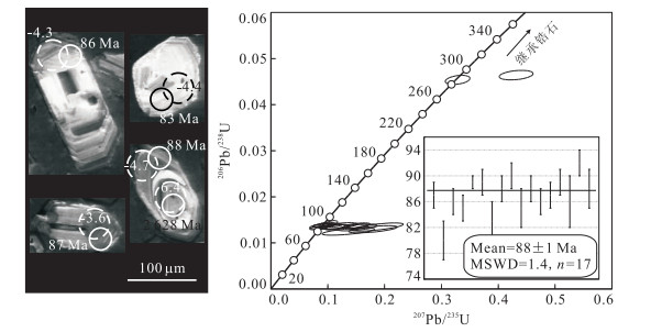
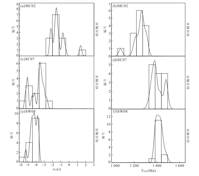
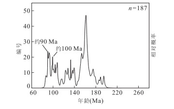
Compared with abundant Precambrian and Early Paleozoic geological records in the Yunkai area, southeast China, Late Yanshanian granitoids are sparsely distributed in the area and are thus reported less. In this study, we present LA-MC-ICP-MS U-Pb age and Hf isotope data of zircons from three representative granites in the Yunkai area, southeastern Guangxi, each from the Michang area, Sanchachong W and Songwang W-Sn-Mo deposits respectively. Zircon U-Pb results indicate that all the granites were formed in Late Yanshanian period, with emplacement ages of 113±1 Ma (Michang biotite granite), 103±1 Ma (Sanchachong biotite granite) and 88±1 Ma (Songwang granite) respectively. The Sanchachong biotite granite and Songwang granite have consistent zircon εHf(t) values (-5.2 to -2.7 and -5.2 to -3.6 respectively) and two-stage Hf modal ages (TDM2) (1.3-1.5 Ga and 1.4-1.5 Ga respectively), indicating that they were formed by reworking of Mesoproterozoic juvenile crust; whereas the Michang biotite granite has relatively higher zircon εHf(t) values of -2.3 to 1.4 and corresponding TDM2 of 1.1-1.3 Ga, which, combined with widespread microgranular mafic enclaves (MMEs) in the granite, suggests that it was formed by mixing of crust- and mantle-derived magmas. In combination of Mesozoic tectono-magmatic evolution in southeast China, the Late Yanshanian magmatism in the Yunkai area was likely related to the rollback and break-off of the subducted Pacific plate during the Cretaceous.
Compared with abundant Precambrian and Early Paleozoic geological records in the Yunkai area, southeast China, Late Yanshanian granitoids are sparsely distributed in the area and are thus reported less. In this study, we present LA-MC-ICP-MS U-Pb age and Hf isotope data of zircons from three representative granites in the Yunkai area, southeastern Guangxi, each from the Michang area, Sanchachong W and Songwang W-Sn-Mo deposits respectively. Zircon U-Pb results indicate that all the granites were formed in Late Yanshanian period, with emplacement ages of 113±1 Ma (Michang biotite granite), 103±1 Ma (Sanchachong biotite granite) and 88±1 Ma (Songwang granite) respectively. The Sanchachong biotite granite and Songwang granite have consistent zircon εHf(t) values (-5.2 to -2.7 and -5.2 to -3.6 respectively) and two-stage Hf modal ages (TDM2) (1.3-1.5 Ga and 1.4-1.5 Ga respectively), indicating that they were formed by reworking of Mesoproterozoic juvenile crust; whereas the Michang biotite granite has relatively higher zircon εHf(t) values of -2.3 to 1.4 and corresponding TDM2 of 1.1-1.3 Ga, which, combined with widespread microgranular mafic enclaves (MMEs) in the granite, suggests that it was formed by mixing of crust- and mantle-derived magmas. In combination of Mesozoic tectono-magmatic evolution in southeast China, the Late Yanshanian magmatism in the Yunkai area was likely related to the rollback and break-off of the subducted Pacific plate during the Cretaceous.


2014, 39(9): 1277-1288, 1300.
doi: 10.3799/dqkx.2014.109
Abstract:
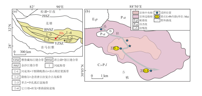
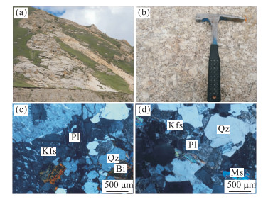
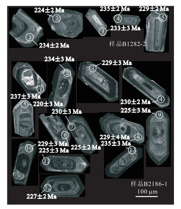
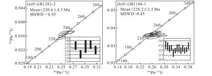
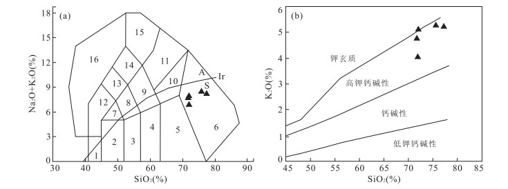
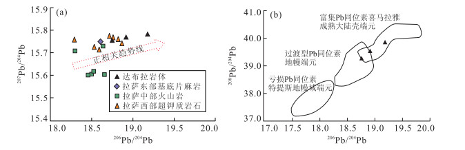
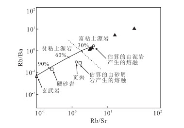
The lithology, LA-ICP-MS zircon U-Pb age, major and trace element geochemistry, Sr-Nd-Pb isotope compositions of Dabula pluton from the middle part of the Gangdise granitoid belt are systematically studied in the paper. Results suggest that the rock type is adamellite, and the pluton is composed of middle-fine grained border facies and middle-coarse grained central facies. The two facies yield weighted mean ages of 230.6±4.3 Ma-228.2±3.5 Ma, with the corresponding age of Late Triassic. The rocks are relatively rich in SiO2 and kalium, with SiO2 content between 71.79%-77.27%; relatively high K(w(K2O)=4.06%-5.26%) and low Ti(w(TiO2)=0.06%-0.40%) contents; A/CNK varies from 1.16-1.19, displaying strong peraluminous characteristics and sharp negative Eu anomalies (δEu=0.06-0.35). Trace element ratio spider diagram displays apparent enrichments of Rb, Th elements, and marked depletions of Ba, Nb, Sr, P and Ti The Sr-Nd isotopes show the granite bodies have the high initial 87Sr/86Sr ratios (0.712 7-0.720 1) and the negative εNd(t) (-10.6) results. Pb isotope feature shows the enrichment of radiogenic Pb. It is concluded that the Dabula pluton was formed by partial melting of mature crustal materials from Gangdise resulted from the underplating of the subduction-related basaltic magmas during the post-collisional extention in the dynamic background associated with the southward Bangong-Nujiang Tethyan seafloor subduction triggered by the collision between the northern Australia and Lhasa terranes.
The lithology, LA-ICP-MS zircon U-Pb age, major and trace element geochemistry, Sr-Nd-Pb isotope compositions of Dabula pluton from the middle part of the Gangdise granitoid belt are systematically studied in the paper. Results suggest that the rock type is adamellite, and the pluton is composed of middle-fine grained border facies and middle-coarse grained central facies. The two facies yield weighted mean ages of 230.6±4.3 Ma-228.2±3.5 Ma, with the corresponding age of Late Triassic. The rocks are relatively rich in SiO2 and kalium, with SiO2 content between 71.79%-77.27%; relatively high K(w(K2O)=4.06%-5.26%) and low Ti(w(TiO2)=0.06%-0.40%) contents; A/CNK varies from 1.16-1.19, displaying strong peraluminous characteristics and sharp negative Eu anomalies (δEu=0.06-0.35). Trace element ratio spider diagram displays apparent enrichments of Rb, Th elements, and marked depletions of Ba, Nb, Sr, P and Ti The Sr-Nd isotopes show the granite bodies have the high initial 87Sr/86Sr ratios (0.712 7-0.720 1) and the negative εNd(t) (-10.6) results. Pb isotope feature shows the enrichment of radiogenic Pb. It is concluded that the Dabula pluton was formed by partial melting of mature crustal materials from Gangdise resulted from the underplating of the subduction-related basaltic magmas during the post-collisional extention in the dynamic background associated with the southward Bangong-Nujiang Tethyan seafloor subduction triggered by the collision between the northern Australia and Lhasa terranes.


2014, 39(9): 1289-1300.
doi: 10.3799/dqkx.2014.110
Abstract:
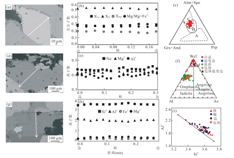
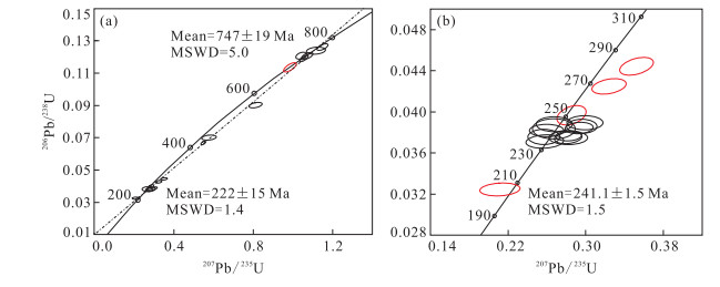
The eclogites in Qianliyan Island, the South Yellow Sea, is important for conducting further research of Dabie-Sulu Orogen. Petrographic and mineralogic studies reveal four main metamorphic stages, including prograde (Stage Ⅰ), eclogite-facies (Stage Ⅱ) metamorphism, and amphibolite-(Stage Ⅲ), greenschist-facies (Stage Ⅳ) retrograde metamorphisms. The metamorphic P-T conditions are estimated as follows: Stage Ⅱ, T=806.3 ℃, P=3.32 GPa; Stage Ⅲ, T=658.68 ℃, P=0.78 GPa; Stage Ⅳ, T < 550 ℃, P < 0.3 GPa. The SHRIMP U-Pb datings of the zircons from eclogites show that the protoliths were formed in Neoproterozoic (about 747±19 Ma), the UHP metamorphism happened in Early Triassic (about 241.1±1.5 Ma), and the amphibolite-facies retrograde metamorphism happened in the end of Triassic (about 205.8 Ma). Using the data mentioned above, metamorphic PTt path of eclogites is constructed. The PTt path shows that the eclogites experienced 2 stages of exhumation and reveals that the Qianliyan uplift is the extension of Sulu Orogen in the South Yellow Sea.
The eclogites in Qianliyan Island, the South Yellow Sea, is important for conducting further research of Dabie-Sulu Orogen. Petrographic and mineralogic studies reveal four main metamorphic stages, including prograde (Stage Ⅰ), eclogite-facies (Stage Ⅱ) metamorphism, and amphibolite-(Stage Ⅲ), greenschist-facies (Stage Ⅳ) retrograde metamorphisms. The metamorphic P-T conditions are estimated as follows: Stage Ⅱ, T=806.3 ℃, P=3.32 GPa; Stage Ⅲ, T=658.68 ℃, P=0.78 GPa; Stage Ⅳ, T < 550 ℃, P < 0.3 GPa. The SHRIMP U-Pb datings of the zircons from eclogites show that the protoliths were formed in Neoproterozoic (about 747±19 Ma), the UHP metamorphism happened in Early Triassic (about 241.1±1.5 Ma), and the amphibolite-facies retrograde metamorphism happened in the end of Triassic (about 205.8 Ma). Using the data mentioned above, metamorphic PTt path of eclogites is constructed. The PTt path shows that the eclogites experienced 2 stages of exhumation and reveals that the Qianliyan uplift is the extension of Sulu Orogen in the South Yellow Sea.


2014, 39(9): 1301-1308.
doi: 10.3799/dqkx.2014.111
Abstract:
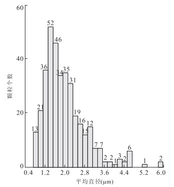
The Particle Phase Analysis (PPA) method by means of Quanta 200 scanning electron microscope (SEM), GENESIS energy disperse spectroscopy (EDS) can analyze particle size and phase automatically. A systematic experimental is carried out to verify the PPA method in this study, using samples of Cenozoic basalts from Datong. We apply the PPA method of EDS to study the thin section and polished section in the geological field for the first time, which yield a series of morphology and chemical composition data of different phases such as phase types, particle number of each phase, average diameter, area, roundness, length-width ratio, chemical composition. The proportion and average particle diameter of each phase can also be obtained as well, overcoming the shortages of traditional method in thin section and polished section. It proves that PPA guarantees significant data for the study of mineralogy, petrology and ore deposit geology.
The Particle Phase Analysis (PPA) method by means of Quanta 200 scanning electron microscope (SEM), GENESIS energy disperse spectroscopy (EDS) can analyze particle size and phase automatically. A systematic experimental is carried out to verify the PPA method in this study, using samples of Cenozoic basalts from Datong. We apply the PPA method of EDS to study the thin section and polished section in the geological field for the first time, which yield a series of morphology and chemical composition data of different phases such as phase types, particle number of each phase, average diameter, area, roundness, length-width ratio, chemical composition. The proportion and average particle diameter of each phase can also be obtained as well, overcoming the shortages of traditional method in thin section and polished section. It proves that PPA guarantees significant data for the study of mineralogy, petrology and ore deposit geology.


2014, 39(9): 1309-1316.
doi: 10.3799/dqkx.2014.112
Abstract:
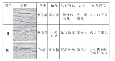
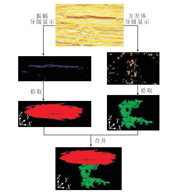
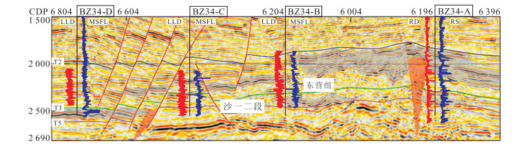
A new method of seismic amplitude and variance cube thresholding display is proposed to enhance the description of the spatial and temporal distribution of volcanics and eruption phases in this paper, on the basis of the contrasting seismic reflections between volcanic channel facies (high continuity and strong seismic amplitude) and overflow facies (low continuity and weak seismic amplitude). Which has been applied and validated in the BZ34-9 block of Huanghekou Sag, Bohai Bay Basin. The study of 3D characterization of volcanics and eruption phases in BZ34-9 block leads to the follows conclusion. (1) Volcanics in the First and Second Members in the Shahejie Formation are located locally in the central part of study area, showing a central eruption style; whereas volcanics in the Dongying Formation are characterized by a widespread distribution in the southern gentle slope of study area, showing central, fissure-central eruption composite style. (2) For the First and Second Members in the Shahejie Formation, volcanic eruption in the eastern part is earlier than that of western part, while the southern one is earlier than that of northern one. (3) For Dongying Formation, volcanic eruption of the southern part is earlier than that of northern part, and the phases of the southern part are also more than those of northern part. (4) Compared to the First and Second Members of the Shahejie Formation, volcanic eruption in the Dongying Formation is characterized by more active, multi-period eruption, and widespread distribution.
A new method of seismic amplitude and variance cube thresholding display is proposed to enhance the description of the spatial and temporal distribution of volcanics and eruption phases in this paper, on the basis of the contrasting seismic reflections between volcanic channel facies (high continuity and strong seismic amplitude) and overflow facies (low continuity and weak seismic amplitude). Which has been applied and validated in the BZ34-9 block of Huanghekou Sag, Bohai Bay Basin. The study of 3D characterization of volcanics and eruption phases in BZ34-9 block leads to the follows conclusion. (1) Volcanics in the First and Second Members in the Shahejie Formation are located locally in the central part of study area, showing a central eruption style; whereas volcanics in the Dongying Formation are characterized by a widespread distribution in the southern gentle slope of study area, showing central, fissure-central eruption composite style. (2) For the First and Second Members in the Shahejie Formation, volcanic eruption in the eastern part is earlier than that of western part, while the southern one is earlier than that of northern one. (3) For Dongying Formation, volcanic eruption of the southern part is earlier than that of northern part, and the phases of the southern part are also more than those of northern part. (4) Compared to the First and Second Members of the Shahejie Formation, volcanic eruption in the Dongying Formation is characterized by more active, multi-period eruption, and widespread distribution.


2014, 39(9): 1317-1322.
doi: 10.3799/dqkx.2014.113
Abstract:
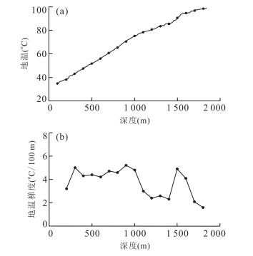
Qinghai Province is characterized by relatively abundant geothermal resources in China, but geothermal energy utilization has been suffering from low efficiency due to the dominant direct use over a long period. Taking Gonghe Basin located in northeastern Qinghai as the study area, we explore the issue in this paper on the basis of the previous geothermal geological and geophysical investigations. A borehole (DR2) with a depth of 1 852 m in the north part of the basin is drilled and geothermal fluid with a temperature up to 84.2 ℃ can be extracted from DR2, based on which the first geothermal power plant in Qinghai with an annual net electricity generation capacity of 114 kW is established. Different from the Yangbajing geothermal power plant in Tibet where high-temperature geothermal fluids are exploited for electricity generation, the Gonghe pilot power plant in Qinghai is a typical example of middle-low-enthalpy geothermal power generation, which leads the optimization of energy structure in Qinghai Province. In general, the geothermal fluids from Gonghe are featured with comparatively high temperatures and discharge rates, and therefore have a great potential for power generation. However, scaling may occur during the exploitation of Gonghe geothermal fluid in view of its chemical composition, which should be addressed in the process.
Qinghai Province is characterized by relatively abundant geothermal resources in China, but geothermal energy utilization has been suffering from low efficiency due to the dominant direct use over a long period. Taking Gonghe Basin located in northeastern Qinghai as the study area, we explore the issue in this paper on the basis of the previous geothermal geological and geophysical investigations. A borehole (DR2) with a depth of 1 852 m in the north part of the basin is drilled and geothermal fluid with a temperature up to 84.2 ℃ can be extracted from DR2, based on which the first geothermal power plant in Qinghai with an annual net electricity generation capacity of 114 kW is established. Different from the Yangbajing geothermal power plant in Tibet where high-temperature geothermal fluids are exploited for electricity generation, the Gonghe pilot power plant in Qinghai is a typical example of middle-low-enthalpy geothermal power generation, which leads the optimization of energy structure in Qinghai Province. In general, the geothermal fluids from Gonghe are featured with comparatively high temperatures and discharge rates, and therefore have a great potential for power generation. However, scaling may occur during the exploitation of Gonghe geothermal fluid in view of its chemical composition, which should be addressed in the process.


2014, 39(9): 1323-1332.
doi: 10.3799/dqkx.2014.114
Abstract:
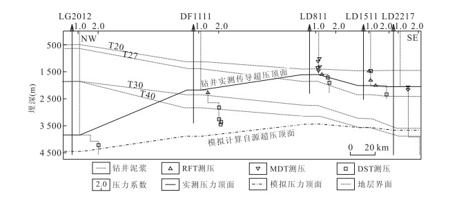
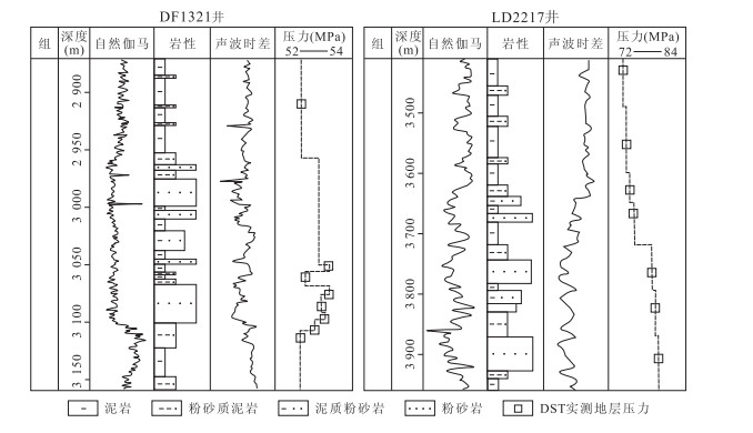
Thermal fluid activity controlled by vertical migration system is one of major geological characteristics in the Yinggehai Basin, which contributes to special hydrocarbon accumulation processes. Combined with a comprehensive interpretation of seismic section, 3D property parameter extractions and thin section observation, The elements of the vertical migration system are analyzed and the diffused and migration overpressure are quantitatively calculated by PetroMod v11 2D software in the paper. It is concluded that. diapir-associated fractures and hydraulic fractures are two main elements of vertical migration system in the basin. The processes vary vertically, with deep migration mainly controlled by hydraulic fractures while the shallow one mainly controlled by diapir-associated fractures in Dongfang area. Fluid activity pierces through the overpressure compartment vertically leading to the diffused overpressure surface being uplifted about 2 000 m in the center of the Yinggehai Basin. 90% of the reservoir remaining pressure comes from migration overpressure at about 3 000 m of the Huangliu Group at present. (3) There are two potential nature gas accumulation zones in the basin, including a top-compartment conductive pressure zone and in-compartment diffused-conductive overpressure zone. As the nature gas reservoir is controlled by hydraulic fracture migration system and has the advantage of being close to the hydrocarbon source kitchen and effective migration, the in-compartment diffused-conductive overpressure zone is the most potential nature gas accumulation zone in the basin.
Thermal fluid activity controlled by vertical migration system is one of major geological characteristics in the Yinggehai Basin, which contributes to special hydrocarbon accumulation processes. Combined with a comprehensive interpretation of seismic section, 3D property parameter extractions and thin section observation, The elements of the vertical migration system are analyzed and the diffused and migration overpressure are quantitatively calculated by PetroMod v11 2D software in the paper. It is concluded that. diapir-associated fractures and hydraulic fractures are two main elements of vertical migration system in the basin. The processes vary vertically, with deep migration mainly controlled by hydraulic fractures while the shallow one mainly controlled by diapir-associated fractures in Dongfang area. Fluid activity pierces through the overpressure compartment vertically leading to the diffused overpressure surface being uplifted about 2 000 m in the center of the Yinggehai Basin. 90% of the reservoir remaining pressure comes from migration overpressure at about 3 000 m of the Huangliu Group at present. (3) There are two potential nature gas accumulation zones in the basin, including a top-compartment conductive pressure zone and in-compartment diffused-conductive overpressure zone. As the nature gas reservoir is controlled by hydraulic fracture migration system and has the advantage of being close to the hydrocarbon source kitchen and effective migration, the in-compartment diffused-conductive overpressure zone is the most potential nature gas accumulation zone in the basin.


2014, 39(9): 1333-1339.
doi: 10.3799/dqkx.2014.115
Abstract:
To ensure safe production of Qinhuangdao 33-1S and 33-2 oilfields, based on the study of test of crushing resistance intensity and regional stress characteristics, a method forecasting pressure required in tension fracture of fault rock is proposed in this paper by using fault rock as a dip rock and contrasting between fault rock and surrounding rock. The new method is tried in forecasting pressures required in tension fracture of fault rock of faults controlling oil accumulation of N1m1 in Qinhuangdao 33-1S and Qinhuangdao 33-2 oilfields. Results indicate that pressures required in tension fracture of fault rock of faults controlling oil accumulation of N1m1 is 25.6-31.3 MPa, with the average value of 29.4 MPa. It is found that safe production can be guaranteed in Qinhuangdao 33-1S and Qinhuangdao 33-2 oilfields if water injecting pressure is smaller than 25.6-31.3 MPa after it is reduced from water injection well to fault. Otherwise, oil might escape to sea bottom from fault.
To ensure safe production of Qinhuangdao 33-1S and 33-2 oilfields, based on the study of test of crushing resistance intensity and regional stress characteristics, a method forecasting pressure required in tension fracture of fault rock is proposed in this paper by using fault rock as a dip rock and contrasting between fault rock and surrounding rock. The new method is tried in forecasting pressures required in tension fracture of fault rock of faults controlling oil accumulation of N1m1 in Qinhuangdao 33-1S and Qinhuangdao 33-2 oilfields. Results indicate that pressures required in tension fracture of fault rock of faults controlling oil accumulation of N1m1 is 25.6-31.3 MPa, with the average value of 29.4 MPa. It is found that safe production can be guaranteed in Qinhuangdao 33-1S and Qinhuangdao 33-2 oilfields if water injecting pressure is smaller than 25.6-31.3 MPa after it is reduced from water injection well to fault. Otherwise, oil might escape to sea bottom from fault.


2014, 39(9): 1340-1348.
doi: 10.3799/dqkx.2014.116
Abstract:
Groundwater in inland arid regions has important functions in vegetation ecology. The water demand of groundwater dependent vegetation ecosystems is an important part of the integrated management of watershed water resources. Advances in studies of ecological function of groundwater resources are reviewed in this paper, and the major key scientific issues in water demand studies of groundwater-dependent vegetation ecosystems in inland arid regions are proposed: ① identification method of groundwater-dependent vegetation ecosystems, ② mechanism of groundwater on vegetation ecosystem, ③ safety limits of the groundwater key attributes, ④ groundwater system structural analysis, ⑤ ecological water allocation plan, ⑥ conceptual model of the relationship on groundwater-natural vegetation system in regional scale. Potential approaches to solve the problems are discussed, which can provide not only ideas for vegetation protection and restoration of ecosystems in arid regions, but also scientific support for improving ecological civilization.
Groundwater in inland arid regions has important functions in vegetation ecology. The water demand of groundwater dependent vegetation ecosystems is an important part of the integrated management of watershed water resources. Advances in studies of ecological function of groundwater resources are reviewed in this paper, and the major key scientific issues in water demand studies of groundwater-dependent vegetation ecosystems in inland arid regions are proposed: ① identification method of groundwater-dependent vegetation ecosystems, ② mechanism of groundwater on vegetation ecosystem, ③ safety limits of the groundwater key attributes, ④ groundwater system structural analysis, ⑤ ecological water allocation plan, ⑥ conceptual model of the relationship on groundwater-natural vegetation system in regional scale. Potential approaches to solve the problems are discussed, which can provide not only ideas for vegetation protection and restoration of ecosystems in arid regions, but also scientific support for improving ecological civilization.


2014, 39(9): 1349-1356.
doi: 10.3799/dqkx.2014.117
Abstract:
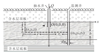
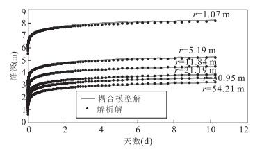
In this paper, three different flow equations, namely, Darcy law, Brinkman equation and Navier-Stoke equation, are employed to simulate the water movement with different flow conditions within and around the wellbore in a confined aquifer. Based on the principles of continuity, three different flow equations are coupled. The coupled model is used to simulate the impact of wellbore in aquifer on the head distribution and water movement. Results indicate that the influence of wellbore increases with the strength of three-dimensional flow and wellbore diameter. In addition, being compared with the sandy soil aquifer, wellbore effect is more obvious in clay or similar aquifers with lower permeability and smaller storage coefficient. By conducting parameter sensitivity analysis, it also can be found that the sensitivity ratio differs in different value zones for the same parameter, while for different parameters, wellbore effect is more sensitive to well diameter than other parameters.
In this paper, three different flow equations, namely, Darcy law, Brinkman equation and Navier-Stoke equation, are employed to simulate the water movement with different flow conditions within and around the wellbore in a confined aquifer. Based on the principles of continuity, three different flow equations are coupled. The coupled model is used to simulate the impact of wellbore in aquifer on the head distribution and water movement. Results indicate that the influence of wellbore increases with the strength of three-dimensional flow and wellbore diameter. In addition, being compared with the sandy soil aquifer, wellbore effect is more obvious in clay or similar aquifers with lower permeability and smaller storage coefficient. By conducting parameter sensitivity analysis, it also can be found that the sensitivity ratio differs in different value zones for the same parameter, while for different parameters, wellbore effect is more sensitive to well diameter than other parameters.


2014, 39(9): 1357-1363.
doi: 10.3799/dqkx.2014.118
Abstract:
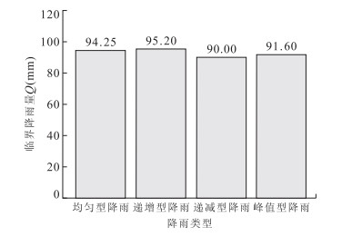
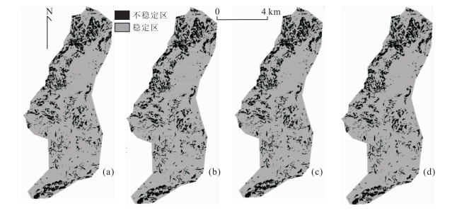
The effect of the rainfall patterns is often ignored in studies of the relationship of rainfall versus shallow stability of landslide. This paper takes four representative rainfall patterns including uniform, delayed, advanced and central ones as the object of study to explore the effect of the rainfall patterns on the height of ground water, based on the hillslope hydrological model proposed by Rosso. And then the infinite slope failure model is applied to establish the stability calculation model for shallow landslide, and the effect of the rainfall patterns on shallow landslide stability is analyzed. Results show that rainfall patterns have strong effect on the stability of shallow landslide, with the delayed rainfall having the lowest safety factor for shallow landslide, followed by uniform rainfall, then central rainfall, and lastly the advanced rainfall. It is found necessary to consider the effect of rainfall patterns for determining of the critical rainfall and analyzing of the susceptibility of shallow landslide in a region.
The effect of the rainfall patterns is often ignored in studies of the relationship of rainfall versus shallow stability of landslide. This paper takes four representative rainfall patterns including uniform, delayed, advanced and central ones as the object of study to explore the effect of the rainfall patterns on the height of ground water, based on the hillslope hydrological model proposed by Rosso. And then the infinite slope failure model is applied to establish the stability calculation model for shallow landslide, and the effect of the rainfall patterns on shallow landslide stability is analyzed. Results show that rainfall patterns have strong effect on the stability of shallow landslide, with the delayed rainfall having the lowest safety factor for shallow landslide, followed by uniform rainfall, then central rainfall, and lastly the advanced rainfall. It is found necessary to consider the effect of rainfall patterns for determining of the critical rainfall and analyzing of the susceptibility of shallow landslide in a region.


2014, 39(9): 1364-1372.
doi: 10.3799/dqkx.2014.119
Abstract:
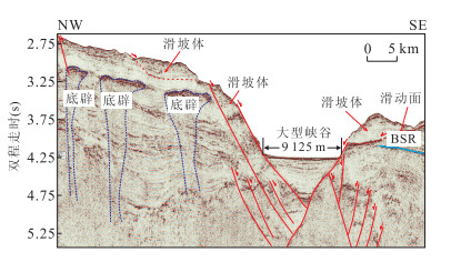
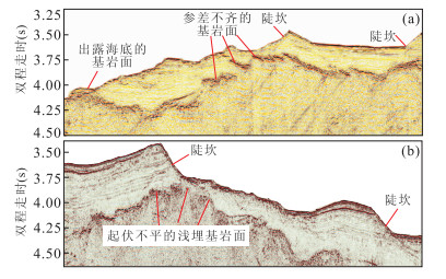
Since Shenhu continental slope in the northern South China Sea is rich in oil and gas resources as well as natural gas hydrate, and its seabed stability is important for oil and gas exploitation and engineering projects. But special study on seabed stability here is far from being enough now. Based on interpretation of 2D seismic data, shallow profiles and multi-beam echo sounder data, this paper focuses on the whole geological environment of this area and identifies 20 different kinds of hazardous geological factors. According to the dynamic source, five hazard types are concluded as follows: tectonic stress-related, gravity-related, hydrodynamics-related, gas effusion-related and soil-related hazards. Each type includes multi-hazardous factors. According to the plan-view distribution of the hazardous geological factors, this area can be divided into the following six hazard regions: intensive areas of buried delta, submarine landslides, volcanism, weak layers, shallow fracture zone and shallow bedrock. Major hazardous factors and their seismic reflection characteristics are presented to provide scientific reference for development of future engineering projects in the study area.
Since Shenhu continental slope in the northern South China Sea is rich in oil and gas resources as well as natural gas hydrate, and its seabed stability is important for oil and gas exploitation and engineering projects. But special study on seabed stability here is far from being enough now. Based on interpretation of 2D seismic data, shallow profiles and multi-beam echo sounder data, this paper focuses on the whole geological environment of this area and identifies 20 different kinds of hazardous geological factors. According to the dynamic source, five hazard types are concluded as follows: tectonic stress-related, gravity-related, hydrodynamics-related, gas effusion-related and soil-related hazards. Each type includes multi-hazardous factors. According to the plan-view distribution of the hazardous geological factors, this area can be divided into the following six hazard regions: intensive areas of buried delta, submarine landslides, volcanism, weak layers, shallow fracture zone and shallow bedrock. Major hazardous factors and their seismic reflection characteristics are presented to provide scientific reference for development of future engineering projects in the study area.


2014, 39(9): 1373-1382.
doi: 10.3799/dqkx.2014.120
Abstract:
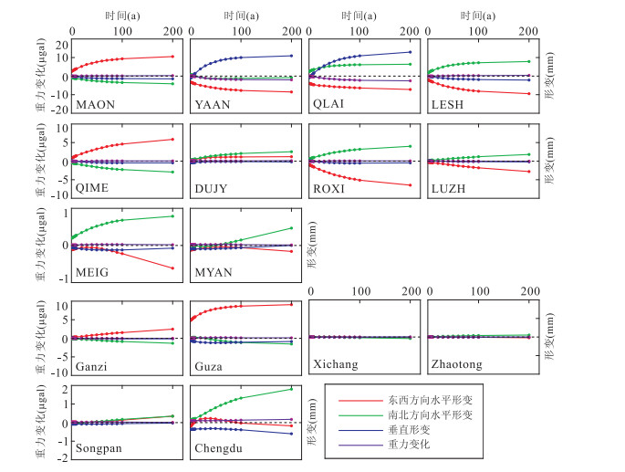
This paper aims at studying the seismogenic process and long-term tectonic process of the source area and explain the post-seismic deformation and gravity data in Lushan earthquake. Based on the layered half-space model, we calculate the co- and post-seismic surface deformations and gravity changes and their time series gained by the GPS and gravity stations, considering regional rheological coefficients, and using the numerical simulation method. It is found that the surface co-seismic deformation shows seismogenic fault is of obvious thrusting characteristics The range of influence of viscoelastic relaxation is significantly enlarged than that of the co-seismic, but changes gradually reduce with the increase of viscousity coefficients. The time-variable curves of the stations show that post-seismic deformation and gravity changes are significant in 50 years after the earthquake, become gentle after 100 years and tend to be stable. The post-seismic observations of the GPS stations are convinced to consider the effect of viscoelastic relaxation except for the MEIG and the MYAN.
This paper aims at studying the seismogenic process and long-term tectonic process of the source area and explain the post-seismic deformation and gravity data in Lushan earthquake. Based on the layered half-space model, we calculate the co- and post-seismic surface deformations and gravity changes and their time series gained by the GPS and gravity stations, considering regional rheological coefficients, and using the numerical simulation method. It is found that the surface co-seismic deformation shows seismogenic fault is of obvious thrusting characteristics The range of influence of viscoelastic relaxation is significantly enlarged than that of the co-seismic, but changes gradually reduce with the increase of viscousity coefficients. The time-variable curves of the stations show that post-seismic deformation and gravity changes are significant in 50 years after the earthquake, become gentle after 100 years and tend to be stable. The post-seismic observations of the GPS stations are convinced to consider the effect of viscoelastic relaxation except for the MEIG and the MYAN.