2015 Vol. 40, No. 10
Display Method:
 PDF 230KB
2015, 40(10): 1607-1615.
doi: 10.3799/dqkx.2015.145
Abstract:
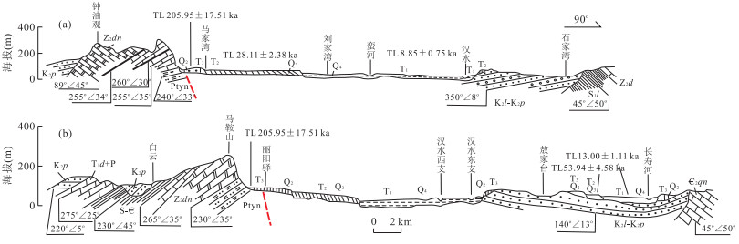
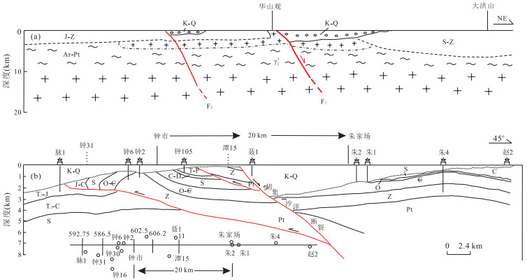
In order to investigate the fault activity and earthquake structure of research area. Field geology, landform survey, fault gouge and terrace dating indicate Huji-shayang fault is characterized by normal faulting and the latest activity time is in late early Pleistocene of Quaternary, approximately 1 136 ka. Furthermore, we make some analysis on relation between regional tectonic stress field and micro-small earthquake activity and fault. Meanwhile, According to field earthquake destroy survey, we draw four earthquake felt area of which size and shape are consistent with strike of the fault. Moreover, we found abnormal phenomenon like fracture and sand-gravel liquefaction in middle Pleistocene reticulate red clay, which suggested a strong shock of magnitude more than 6.0 strike this area of Zhongxiang. Based on these understanding, we discuss the seismogenic structure of Zhongxiang earthquake happening in the year of 1407, 1469, 1603 of magnitude 5.0~5.5. Some conclusion that Hujia-shayang fault controlling Han river garben is possible seismogenic structure of Zhongxiang earthquake can be drawn, which confirm that non-active fault has an ability to produce moderate earthquake in east China.
In order to investigate the fault activity and earthquake structure of research area. Field geology, landform survey, fault gouge and terrace dating indicate Huji-shayang fault is characterized by normal faulting and the latest activity time is in late early Pleistocene of Quaternary, approximately 1 136 ka. Furthermore, we make some analysis on relation between regional tectonic stress field and micro-small earthquake activity and fault. Meanwhile, According to field earthquake destroy survey, we draw four earthquake felt area of which size and shape are consistent with strike of the fault. Moreover, we found abnormal phenomenon like fracture and sand-gravel liquefaction in middle Pleistocene reticulate red clay, which suggested a strong shock of magnitude more than 6.0 strike this area of Zhongxiang. Based on these understanding, we discuss the seismogenic structure of Zhongxiang earthquake happening in the year of 1407, 1469, 1603 of magnitude 5.0~5.5. Some conclusion that Hujia-shayang fault controlling Han river garben is possible seismogenic structure of Zhongxiang earthquake can be drawn, which confirm that non-active fault has an ability to produce moderate earthquake in east China.


2015, 40(10): 1616-1620.
doi: 10.3799/dqkx.2015.146
Abstract:
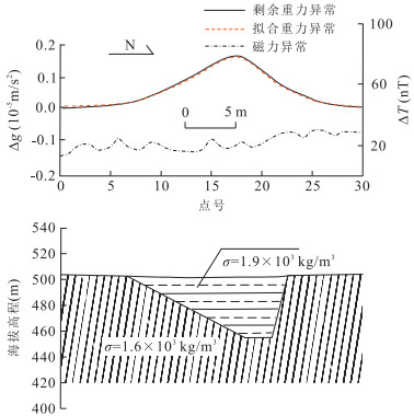
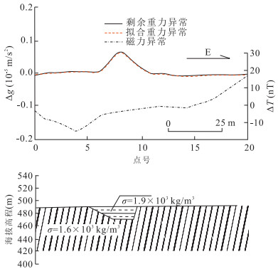
The method validity has been tested on those sites known using high precision gravity and magnetic survey, which are for to explore the distribution of underground relics, to choose geophysical prospecting method and technology being fit to existing character in the area. The test results have showed that the range of ancient construction base site can be confirmed and the underground distribution can be conjectured by using high precision gravity survey. It is valid to explore the accompanying pits burned and also to find the accompanying tombs by using high precision magnetic method. The test results have yet provided the foundation to explore the similar cultural relics in the Emperor Qinshihuang mausoleum area in future.
The method validity has been tested on those sites known using high precision gravity and magnetic survey, which are for to explore the distribution of underground relics, to choose geophysical prospecting method and technology being fit to existing character in the area. The test results have showed that the range of ancient construction base site can be confirmed and the underground distribution can be conjectured by using high precision gravity survey. It is valid to explore the accompanying pits burned and also to find the accompanying tombs by using high precision magnetic method. The test results have yet provided the foundation to explore the similar cultural relics in the Emperor Qinshihuang mausoleum area in future.


2015, 40(10): 1621-1642.
doi: 10.3799/dqkx.2015.147
Abstract:
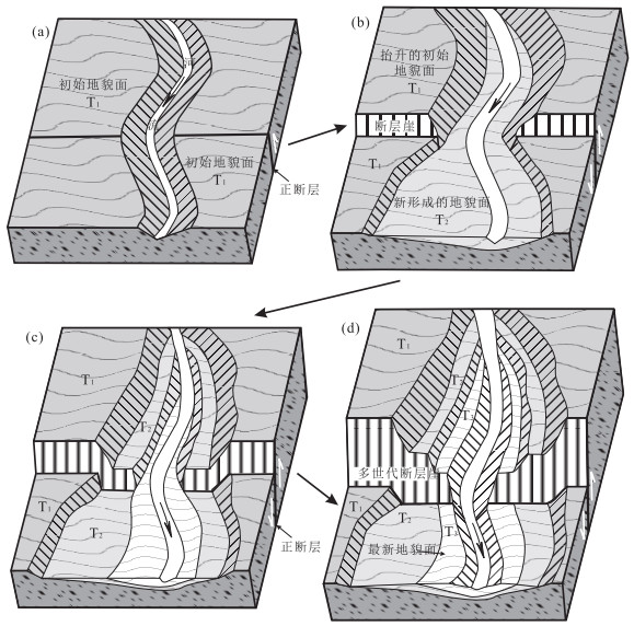
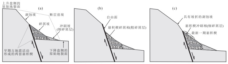
The Angang basin is a typical half-graben of the Nyemo graben group of the central Yadong-Gulu rift in south Tibet. Multiple-generation fault scarps, earthquake-induced large landslides, and colluvial wedges of fault scarps along the west margin boundary normal fault of the graben contain rich information of prehistoric earthquake events and are effective marks to identify prehistoric large earthquakes (M≥7.0). Based on the measured vertical displacements of multiple-generation fault scarps and OSL and 14C dating results of 36 samples from river terraces and fault scarp profiles, it can be estimated that the vertical displacement rate of western main boundary fault zone of Angang graben is 0.8-1.3 mm/a and at least 6 large earthquakes have occurred in the Angang graben since about 23-26 ka. According to the length and the maximum vertical displacement of earthquake fault, the magnitude of such large earthquakes should be in a range of Mw7.0-7.2. The newly study result on paleoearthquake show that the ages of the last two large earthquakes should be about 5.8±1.0 ka and 2.4±0.2 ka before presents respectively, and the average recurrence interval between two large earthquakes would roughly be 3.3-3.6 ka in Angang, but the recurrence interval of large earthquakes in the whole Nyemo graben group should be short and inferred to be 1.0-1.2 ka. Prominent normal faulting and frequent large earthquakes indicate that the large earthquake activity is consistent with clusterd-slip model and are in the seismic active period since about 23-26 ka in the Angang graben and Nyemo graben group.
The Angang basin is a typical half-graben of the Nyemo graben group of the central Yadong-Gulu rift in south Tibet. Multiple-generation fault scarps, earthquake-induced large landslides, and colluvial wedges of fault scarps along the west margin boundary normal fault of the graben contain rich information of prehistoric earthquake events and are effective marks to identify prehistoric large earthquakes (M≥7.0). Based on the measured vertical displacements of multiple-generation fault scarps and OSL and 14C dating results of 36 samples from river terraces and fault scarp profiles, it can be estimated that the vertical displacement rate of western main boundary fault zone of Angang graben is 0.8-1.3 mm/a and at least 6 large earthquakes have occurred in the Angang graben since about 23-26 ka. According to the length and the maximum vertical displacement of earthquake fault, the magnitude of such large earthquakes should be in a range of Mw7.0-7.2. The newly study result on paleoearthquake show that the ages of the last two large earthquakes should be about 5.8±1.0 ka and 2.4±0.2 ka before presents respectively, and the average recurrence interval between two large earthquakes would roughly be 3.3-3.6 ka in Angang, but the recurrence interval of large earthquakes in the whole Nyemo graben group should be short and inferred to be 1.0-1.2 ka. Prominent normal faulting and frequent large earthquakes indicate that the large earthquake activity is consistent with clusterd-slip model and are in the seismic active period since about 23-26 ka in the Angang graben and Nyemo graben group.


2015, 40(10): 1643-1652.
doi: 10.3799/dqkx.2015.148
Abstract:
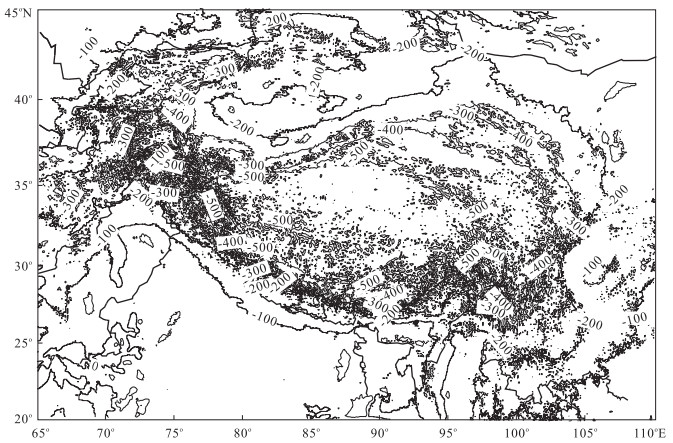
Gravity anomaly data are the results of gravity force field by all underground sources, including information in the shallow and deep parts of the earth. The studies of satellite gravity field have been increased in recent years, which provide important information for the study of deep structures under the Tibetan Plateau. Using EIGEN-6C2 gravity field data, we first analyze the Bouguer gravity anomaly and isostatic gravity anomaly from one to five scale decomposition based on multi-resolution analysis method. Then distribution characteristics of gravity anomaly sources in different depths are evaluated with the help of other geophysical factors, in order to recover the geometric characteristics in different scale. Second, we estimate the approximate depths of the geologic bodies using the power spectral analysis on the decomposed anomalies from first to fifth order. Third, the edge detection method based on Canny operator is employed to identify the undistinguished fractures, to further determine the block boundary in the Tibetan plateau and to divide blocks and sub-blocks that are active tectonically. Final, after sedimentary and lithosphere corrections, the three dimensional Parker-Oldenbarg inverse theory on the Bouguer anomaly is applied to invert Moho depths in Tibetan plateau.
Gravity anomaly data are the results of gravity force field by all underground sources, including information in the shallow and deep parts of the earth. The studies of satellite gravity field have been increased in recent years, which provide important information for the study of deep structures under the Tibetan Plateau. Using EIGEN-6C2 gravity field data, we first analyze the Bouguer gravity anomaly and isostatic gravity anomaly from one to five scale decomposition based on multi-resolution analysis method. Then distribution characteristics of gravity anomaly sources in different depths are evaluated with the help of other geophysical factors, in order to recover the geometric characteristics in different scale. Second, we estimate the approximate depths of the geologic bodies using the power spectral analysis on the decomposed anomalies from first to fifth order. Third, the edge detection method based on Canny operator is employed to identify the undistinguished fractures, to further determine the block boundary in the Tibetan plateau and to divide blocks and sub-blocks that are active tectonically. Final, after sedimentary and lithosphere corrections, the three dimensional Parker-Oldenbarg inverse theory on the Bouguer anomaly is applied to invert Moho depths in Tibetan plateau.


2015, 40(10): 1653-1666.
doi: 10.3799/dqkx.2015.149
Abstract:
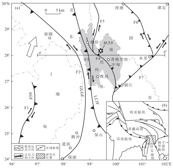
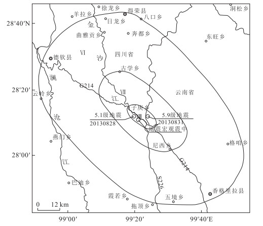
At 08∶04 of August 31st, 2013, an earthquake with a magnitude of Ms 5.9 occurred in Shangrila county of Tibetan Autonomous Prefecture, Yunnan Province (28.1°N, 99.4°E). The depth of the hypocenter is 10 km. The study area is seismically active in history and prone to earthquake in northwestern Yunnan. Then the focal mechanism solutions show that the Diqing Ms 5.9 earthquake is of normal faulting with dextral strike-slip and the attitude of the NW nodal plane is consistent to the Deqin-Zhongdian fault. In this paper, we discuss the bouguer anomaly near the epicenter using EIGEN-6C2 model, and the epicenter is located at the Moho depth undulating position, and place where the crustal thickness is unstable. From the profile of P wave velocity and crustal structure, we know that low-velocity layer exists at the bottom of the upper crust, and the layer is likely to be closely related to seismic energy accumulating and storing. The joint location of the edge of the low-velocity (high conductivity) layer and the Deqin-Zhongdian fractures is the location for the focus to release the accumulating energy. This provides a new case of the three-level tectonic model for intra-plate earthquake.
At 08∶04 of August 31st, 2013, an earthquake with a magnitude of Ms 5.9 occurred in Shangrila county of Tibetan Autonomous Prefecture, Yunnan Province (28.1°N, 99.4°E). The depth of the hypocenter is 10 km. The study area is seismically active in history and prone to earthquake in northwestern Yunnan. Then the focal mechanism solutions show that the Diqing Ms 5.9 earthquake is of normal faulting with dextral strike-slip and the attitude of the NW nodal plane is consistent to the Deqin-Zhongdian fault. In this paper, we discuss the bouguer anomaly near the epicenter using EIGEN-6C2 model, and the epicenter is located at the Moho depth undulating position, and place where the crustal thickness is unstable. From the profile of P wave velocity and crustal structure, we know that low-velocity layer exists at the bottom of the upper crust, and the layer is likely to be closely related to seismic energy accumulating and storing. The joint location of the edge of the low-velocity (high conductivity) layer and the Deqin-Zhongdian fractures is the location for the focus to release the accumulating energy. This provides a new case of the three-level tectonic model for intra-plate earthquake.


2015, 40(10): 1667-1676.
doi: 10.3799/dqkx.2015.150
Abstract:
An instantaneous intense rainfall occurred in the Fengshan County area, Guangxi Province of South China on June 27, 2010. One day later, an strong seismicity with shallow depth and magnitudes less than ML3.0 occurred. It caused severe economic losses. It is not clear whether or not the activity of this shallow earthquake swarm is correlated with the heavy rainfall. Based on the tectonic setting in the study area, the activity characteristics, focal mechanism solutions of the earthquake swarm and its relationship with faults are investigated, and then a stress model is proposed to analysis fault slip triggered by pore-fluid pressure. It is concluded that the activity of this shallow earthquake swarm is highly correlated with the heavy rainfall after a prolonged drought in this region, including the occurrence time, epicenter location and the frequency. Prolonged drought and lack of groundwater in karst areas have a positive effect on the accumulation of stress in the shallow crust. In karst regions, the underground caverns, river and vertical cracks can be propitious to the fast penetration of surface water. Pore pressure changes cause the fault strength weakening, thereby trigger the unlocking and slip on the shallow part of fault. Discrete close overpressure fluid and abnormal stress field formed due to the shallow slip of fault. The shallow seismic activity comes from the slip and collapse of shallow sub-fractures and caves in karst regions.
An instantaneous intense rainfall occurred in the Fengshan County area, Guangxi Province of South China on June 27, 2010. One day later, an strong seismicity with shallow depth and magnitudes less than ML3.0 occurred. It caused severe economic losses. It is not clear whether or not the activity of this shallow earthquake swarm is correlated with the heavy rainfall. Based on the tectonic setting in the study area, the activity characteristics, focal mechanism solutions of the earthquake swarm and its relationship with faults are investigated, and then a stress model is proposed to analysis fault slip triggered by pore-fluid pressure. It is concluded that the activity of this shallow earthquake swarm is highly correlated with the heavy rainfall after a prolonged drought in this region, including the occurrence time, epicenter location and the frequency. Prolonged drought and lack of groundwater in karst areas have a positive effect on the accumulation of stress in the shallow crust. In karst regions, the underground caverns, river and vertical cracks can be propitious to the fast penetration of surface water. Pore pressure changes cause the fault strength weakening, thereby trigger the unlocking and slip on the shallow part of fault. Discrete close overpressure fluid and abnormal stress field formed due to the shallow slip of fault. The shallow seismic activity comes from the slip and collapse of shallow sub-fractures and caves in karst regions.


2015, 40(10): 1677-1688.
doi: 10.3799/dqkx.2015.151
Abstract:
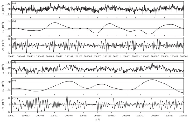
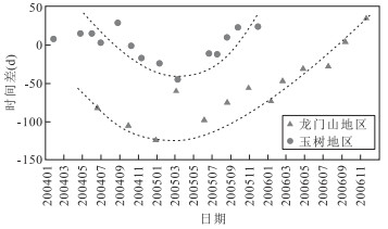
According to the characteristic periods of climate elements, component signals caused by climate and human factors are decomposed and recognized from the volume mixing ratio of methane in the troposphere, using wavelet analysis method. And then, extract the variation of methane concentration signal caused by geological activity (geological methane). On this basis, analyze the relationship between the variation of geological methane concentration and seismic activity, take Longmenshan and Yushu areas for examples. The result shows that there is an obviously corresponding relationship between the variation of geological methane concentration and seismic activity. In addition, 13 peak values of geological methane concentration occurrence in Longmenshan area in 2004—2006, and 14 peaks values occurrence in Yushu area in 2004—2005. In total, 21 cases (78%) of the time difference of geological methane and seismic activity peak are less than 2 months, and the time difference decrease firstly and then increase in February 2005, in these two areas. And, there is a positive correlation between geological methane concentration and seismic activity peak values in Longmenshan area. Finally, preliminary study on the source and variation of geological methane, the results indicate that geological methane comes from upwelling of mantle and crust fluids, and its concentration correlated closely with the temperature and pressure of ductile rheological layer and "microcracks" and "Rupture chain" in mid-upper crust.
According to the characteristic periods of climate elements, component signals caused by climate and human factors are decomposed and recognized from the volume mixing ratio of methane in the troposphere, using wavelet analysis method. And then, extract the variation of methane concentration signal caused by geological activity (geological methane). On this basis, analyze the relationship between the variation of geological methane concentration and seismic activity, take Longmenshan and Yushu areas for examples. The result shows that there is an obviously corresponding relationship between the variation of geological methane concentration and seismic activity. In addition, 13 peak values of geological methane concentration occurrence in Longmenshan area in 2004—2006, and 14 peaks values occurrence in Yushu area in 2004—2005. In total, 21 cases (78%) of the time difference of geological methane and seismic activity peak are less than 2 months, and the time difference decrease firstly and then increase in February 2005, in these two areas. And, there is a positive correlation between geological methane concentration and seismic activity peak values in Longmenshan area. Finally, preliminary study on the source and variation of geological methane, the results indicate that geological methane comes from upwelling of mantle and crust fluids, and its concentration correlated closely with the temperature and pressure of ductile rheological layer and "microcracks" and "Rupture chain" in mid-upper crust.


2015, 40(10): 1689-1700.
doi: 10.3799/dqkx.2015.152
Abstract:
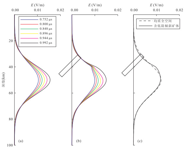
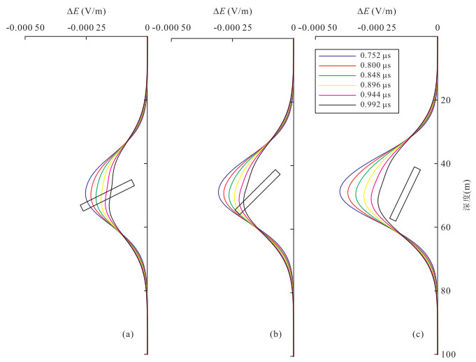
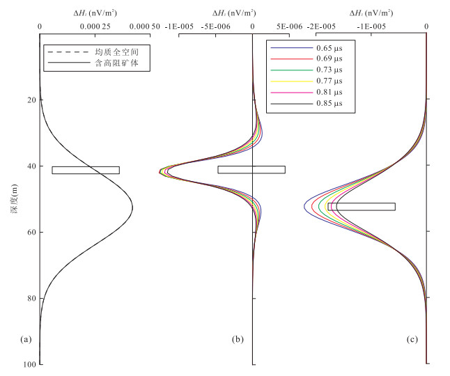
The transient electromagnetic response of conductive orebody is studied so as to provide a reliable basis for the exploration of the transient electromagnetic in borehole. Finite-different time-domain method and Mur absorbing boundary were used to simulate three-dimensional transient electromagnetic field generated by magnetic dipole source, and establishing the geometric model of low resistivity orebody with different depth, different sizes, different dips, as well as high resistivity orebody in the whole space. During the data processing, excluding the impact of conductive whole space to the total response and getting the anomalous secondary field which reflects the target characteristics. The regularity of the geometric model was analyzed, and the result shows that the orebody with different depth, sizes, dips and conductivity have very different response. The method for identification of tabular orbody has a significant effect.
The transient electromagnetic response of conductive orebody is studied so as to provide a reliable basis for the exploration of the transient electromagnetic in borehole. Finite-different time-domain method and Mur absorbing boundary were used to simulate three-dimensional transient electromagnetic field generated by magnetic dipole source, and establishing the geometric model of low resistivity orebody with different depth, different sizes, different dips, as well as high resistivity orebody in the whole space. During the data processing, excluding the impact of conductive whole space to the total response and getting the anomalous secondary field which reflects the target characteristics. The regularity of the geometric model was analyzed, and the result shows that the orebody with different depth, sizes, dips and conductivity have very different response. The method for identification of tabular orbody has a significant effect.


2015, 40(10): 1701-1709.
doi: 10.3799/dqkx.2015.153
Abstract:
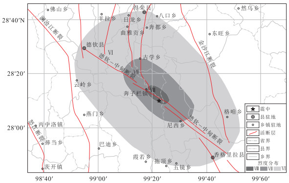
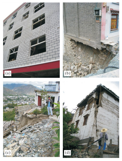
On August 28st and 31st, 2013, two earthquakes with magnitude of 5.1 and 5.9 occurred on the boundary between Deqing County, Yunnan Province, and Derong County, Sichuan Province. In order to evaluate the damage of the earthquake, we investigated on lots of seismo-geological hazards induced by the earthquakes and conducted the field investigation of geological structural section about the fractures near the epicenter. Those two earthquakes successively occurring at the adjacent position led to the intensity of this earthquake higher than that of the same magnitude. The maximum intensity of the 5.9 earthquake is Ⅷ degree and the perceptible area is relatively large. The macroseismic epicenter is about 5.1km from the 5.1 microseismic epicenter is roughly located at the middle of the two microseismic epicenter (28.20°N, 99.36°E). The isoseismic line is shaped as an anomalous ellipse and the orientation of its long axis is NW-SE orientation along the Deqin-Zhongdian fault. According to the field investigation of geological structural section about the fractures near the epicenter, the focal mechanism solution data and the special distribution characteristics of the aftershocks, we preliminary infer that the seismogenic structure is Deqin-Zhongdian fault and the Deqing-Derong 5.9 earthquake is a normal fault type earthquake characterized by strike-slip.
On August 28st and 31st, 2013, two earthquakes with magnitude of 5.1 and 5.9 occurred on the boundary between Deqing County, Yunnan Province, and Derong County, Sichuan Province. In order to evaluate the damage of the earthquake, we investigated on lots of seismo-geological hazards induced by the earthquakes and conducted the field investigation of geological structural section about the fractures near the epicenter. Those two earthquakes successively occurring at the adjacent position led to the intensity of this earthquake higher than that of the same magnitude. The maximum intensity of the 5.9 earthquake is Ⅷ degree and the perceptible area is relatively large. The macroseismic epicenter is about 5.1km from the 5.1 microseismic epicenter is roughly located at the middle of the two microseismic epicenter (28.20°N, 99.36°E). The isoseismic line is shaped as an anomalous ellipse and the orientation of its long axis is NW-SE orientation along the Deqin-Zhongdian fault. According to the field investigation of geological structural section about the fractures near the epicenter, the focal mechanism solution data and the special distribution characteristics of the aftershocks, we preliminary infer that the seismogenic structure is Deqin-Zhongdian fault and the Deqing-Derong 5.9 earthquake is a normal fault type earthquake characterized by strike-slip.


2015, 40(10): 1710-1722.
doi: 10.3799/dqkx.2015.154
Abstract:
In order to investigate seismogenic structure and seismic mechanism of Lushan Mw6.6 earthquake on 20 April 2013, based on focal mechanism solutions of 114 M≥3.0 aftershocks from 20 April to 1 June 2013, we analyzed spatial and temporal distribution characteristic of focal mechanism and stress field. The results are as follows. (1) The focal mechanism types of Lushan M≥3.0 aftershocks show that thrust type is dominant faulting behavior, strike-slip type takes second place, normal type is least, the orientation of P-axis have a good consistency, the dominant direction is near NWW-SEE, dip angle is from 0° to 30°, it shows that aftershock activities are controlled by regional stress field. (2) The orientations of compressive stress (S1) exists obvious space partition difference in Lushan aftershock zone, the epicenter of main shock as boundary, the S1 orientation presents NWW in the south of aftershock zone, and it is anticlockwise rotation from NW to NE in the north of aftershock zone. The dislocation type of causative fault in the north of aftershock zone is mainly characterized by thrust with the component of strike-slip. (3) The change of S1 orientation with time is not obvious, it presents near NWW direction, but its dip angle gradually becomes level, stress tensor variance gradually becomes big, and the focal mechanism is mainly thrust behavior all the time, but it becomes relatively untidy with time, it reflects that seismic source stress field continually adjusts with time. (4) The depth profiles show that angle between S1 direction and causative fault strike is 80°-120° in most area, it is almost perpendicular to fault strike, the trend of focal fault plane is NW, it shows that Lushan earthquake sequence is controlled by near level compressive stress which is perpendicular to causative fault, it belongs to typical thrust fault.
In order to investigate seismogenic structure and seismic mechanism of Lushan Mw6.6 earthquake on 20 April 2013, based on focal mechanism solutions of 114 M≥3.0 aftershocks from 20 April to 1 June 2013, we analyzed spatial and temporal distribution characteristic of focal mechanism and stress field. The results are as follows. (1) The focal mechanism types of Lushan M≥3.0 aftershocks show that thrust type is dominant faulting behavior, strike-slip type takes second place, normal type is least, the orientation of P-axis have a good consistency, the dominant direction is near NWW-SEE, dip angle is from 0° to 30°, it shows that aftershock activities are controlled by regional stress field. (2) The orientations of compressive stress (S1) exists obvious space partition difference in Lushan aftershock zone, the epicenter of main shock as boundary, the S1 orientation presents NWW in the south of aftershock zone, and it is anticlockwise rotation from NW to NE in the north of aftershock zone. The dislocation type of causative fault in the north of aftershock zone is mainly characterized by thrust with the component of strike-slip. (3) The change of S1 orientation with time is not obvious, it presents near NWW direction, but its dip angle gradually becomes level, stress tensor variance gradually becomes big, and the focal mechanism is mainly thrust behavior all the time, but it becomes relatively untidy with time, it reflects that seismic source stress field continually adjusts with time. (4) The depth profiles show that angle between S1 direction and causative fault strike is 80°-120° in most area, it is almost perpendicular to fault strike, the trend of focal fault plane is NW, it shows that Lushan earthquake sequence is controlled by near level compressive stress which is perpendicular to causative fault, it belongs to typical thrust fault.


2015, 40(10): 1723-1740.
doi: 10.3799/dqkx.2015.155
Abstract:
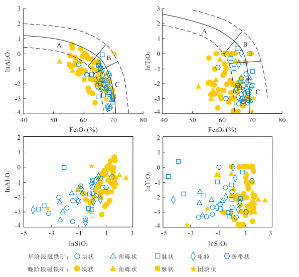
The Songhu iron deposit located in the middle Awulale Fe-Cu metallogenic belt of Western Tianshan. The minralization of Songhu iron deposit included two metallogenic periods which could be further subdivided into six metallogenic stages, i. e., sulfide-k-feldspar stage, hematite-calcite-chlorite stage, magnetite-chlorite-k-feldspar stage(early stage of magnetite), magnetite-sulfide stage(late stage of magnetite), calcite-chalcopyrite stage and supergene period. In order to analyze the characteristics and causes of its components, Electron microprobe analyses show that the magnetites formed in early stage were rich in FeOT and poor in TiO2, Al2O3, MgO, MnO, which are similar to those of contact-metasomatic deposits. High content of SiO2 suggests that the formation of early magnetite was associated with acidic magmatic hydrothermal system. Late magnetite stage was the main minralization stage which was widely superimposed on ores formed during the early stage. Magnetites have lower content of FeOT and higher content of TiO2, MnO, V2O3, MgO, Al2O3. Both ternary plot of TiO2-Al2O3-MgO and Ca+Al+Mn vs. Ti+V discriminant diagram suggest that late magnetites were the product of hydrothermal mineralization. Considering the geological features of ore deposit, we infer that late magnetites are formed in the late magmatic activity or period of inactivity with the participation of sea water.
The Songhu iron deposit located in the middle Awulale Fe-Cu metallogenic belt of Western Tianshan. The minralization of Songhu iron deposit included two metallogenic periods which could be further subdivided into six metallogenic stages, i. e., sulfide-k-feldspar stage, hematite-calcite-chlorite stage, magnetite-chlorite-k-feldspar stage(early stage of magnetite), magnetite-sulfide stage(late stage of magnetite), calcite-chalcopyrite stage and supergene period. In order to analyze the characteristics and causes of its components, Electron microprobe analyses show that the magnetites formed in early stage were rich in FeOT and poor in TiO2, Al2O3, MgO, MnO, which are similar to those of contact-metasomatic deposits. High content of SiO2 suggests that the formation of early magnetite was associated with acidic magmatic hydrothermal system. Late magnetite stage was the main minralization stage which was widely superimposed on ores formed during the early stage. Magnetites have lower content of FeOT and higher content of TiO2, MnO, V2O3, MgO, Al2O3. Both ternary plot of TiO2-Al2O3-MgO and Ca+Al+Mn vs. Ti+V discriminant diagram suggest that late magnetites were the product of hydrothermal mineralization. Considering the geological features of ore deposit, we infer that late magnetites are formed in the late magmatic activity or period of inactivity with the participation of sea water.


2015, 40(10): 1741-1754.
doi: 10.3799/dqkx.2015.156
Abstract:
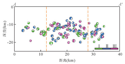
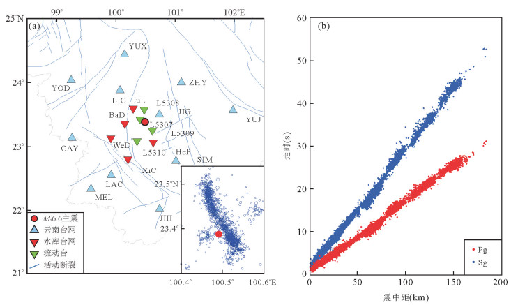
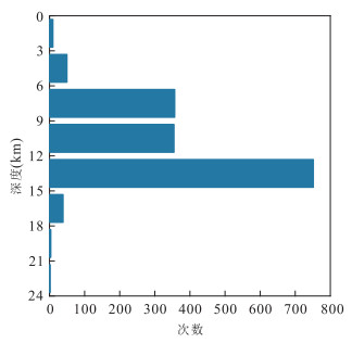
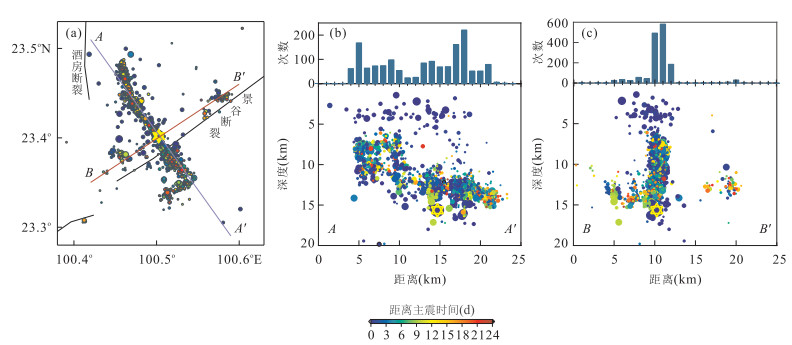
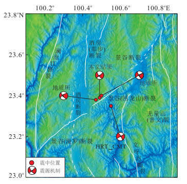
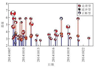
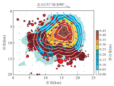
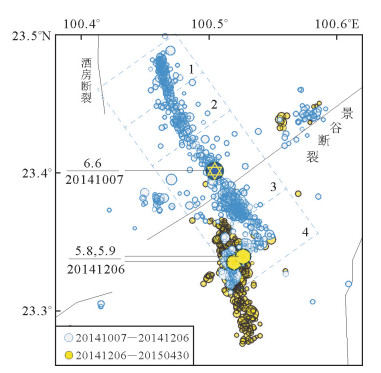
The research of Yunnan Jinggu earthquake is not so intensive. To discuss the seismogenic structure and distribution of sequences of Jinggu Ms6.6 earthquake, 7 October 2014, we relocated the mainshock by using the 3D velocity model of Yunnan and Sichuan province (Loc3dSB), and then relocated the sequences during 7th to 31th October 2014 using the double-difference relocation algorithm, by using and phase data from seismic network of Yunnan province. Furthermore the focal mechanism solutions are derived by using P-wave polarity first-motion and amplitude ratio method. The sequences appear to be strike-slip type mostly, with the principal compressive stress axis trends both NNE and NE directions. And the sequences are distributed dominantly linearly shaped in the NW direction with its southeast endpoint appears deeper than northwest. Both of which indicate that the early major rupture plane is the NW nodal plan, appears to be a right-lateral strike-slip faulting with a small normal component. Meanwhile the linearly shaped distribution and focal mechanisms varies with locations on different segments, with clear end-points and transform segment. Furthermore, aftershocks at SE end-point expand gradually to new geometrically unclear segment, which may indicate another rupture.
The research of Yunnan Jinggu earthquake is not so intensive. To discuss the seismogenic structure and distribution of sequences of Jinggu Ms6.6 earthquake, 7 October 2014, we relocated the mainshock by using the 3D velocity model of Yunnan and Sichuan province (Loc3dSB), and then relocated the sequences during 7th to 31th October 2014 using the double-difference relocation algorithm, by using and phase data from seismic network of Yunnan province. Furthermore the focal mechanism solutions are derived by using P-wave polarity first-motion and amplitude ratio method. The sequences appear to be strike-slip type mostly, with the principal compressive stress axis trends both NNE and NE directions. And the sequences are distributed dominantly linearly shaped in the NW direction with its southeast endpoint appears deeper than northwest. Both of which indicate that the early major rupture plane is the NW nodal plan, appears to be a right-lateral strike-slip faulting with a small normal component. Meanwhile the linearly shaped distribution and focal mechanisms varies with locations on different segments, with clear end-points and transform segment. Furthermore, aftershocks at SE end-point expand gradually to new geometrically unclear segment, which may indicate another rupture.


2015, 40(10): 1755-1766.
doi: 10.3799/dqkx.2015.157
Abstract:
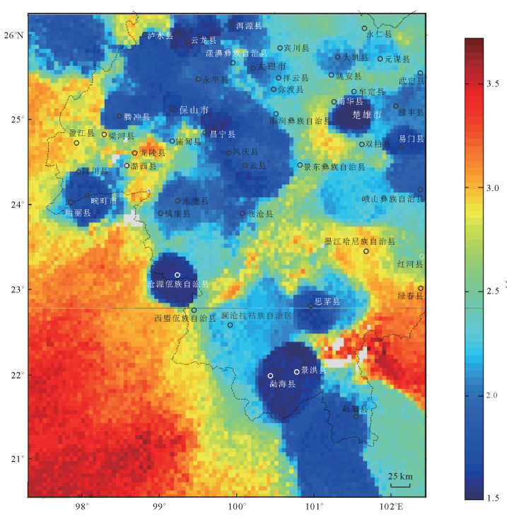
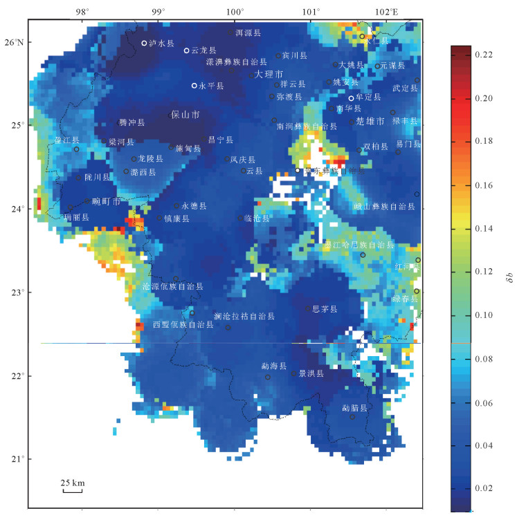
Southwestern Yunnan is located in the southeast edge of the Tibetan plateau, is one of strong continental tectonic activities and frequent earthquake area in our country. In this paper, based on the principle of negative correlation between regional seismic b-value and crust internal stress distribution, we made the b values map by the maximum likelihood method and combined with the feature of regional seism tectonic background and active faults, analysis spatial difference of distribution b values along the fault belt, reflect the level of stress accumulation and activity habits in the different fault belt and the same fault different section, which reflects the spatial difference of seismic risk. The research result shows that the b value of the study area is 0.3 to 1.2, the average value of b is 0.576, δb is 0.046; the distribution b value and different sections in the Fault belt and fracture belt are uneven. The southern section of the LANCANG river fault, NU river fault etc in the low b value area of the study area, it suggests that this region is at a relatively high stress state and the possibility of strong earthquake in the future. On the contrary, Ailaoshan fault belt、the eastern and western section of the Longling-Ruili fault belt etc. in the high b value area of the study area, it suggests that this region is at a relatively low stress state and the possibility of small earthquake in the next few years. The researching methods of this article and its conclusion are available for risk evaluation research and long-term seismicity prediction research as a reference.
Southwestern Yunnan is located in the southeast edge of the Tibetan plateau, is one of strong continental tectonic activities and frequent earthquake area in our country. In this paper, based on the principle of negative correlation between regional seismic b-value and crust internal stress distribution, we made the b values map by the maximum likelihood method and combined with the feature of regional seism tectonic background and active faults, analysis spatial difference of distribution b values along the fault belt, reflect the level of stress accumulation and activity habits in the different fault belt and the same fault different section, which reflects the spatial difference of seismic risk. The research result shows that the b value of the study area is 0.3 to 1.2, the average value of b is 0.576, δb is 0.046; the distribution b value and different sections in the Fault belt and fracture belt are uneven. The southern section of the LANCANG river fault, NU river fault etc in the low b value area of the study area, it suggests that this region is at a relatively high stress state and the possibility of strong earthquake in the future. On the contrary, Ailaoshan fault belt、the eastern and western section of the Longling-Ruili fault belt etc. in the high b value area of the study area, it suggests that this region is at a relatively low stress state and the possibility of small earthquake in the next few years. The researching methods of this article and its conclusion are available for risk evaluation research and long-term seismicity prediction research as a reference.


2015, 40(10): 1767-1780.
doi: 10.3799/dqkx.2015.158
Abstract:
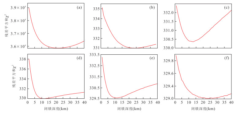
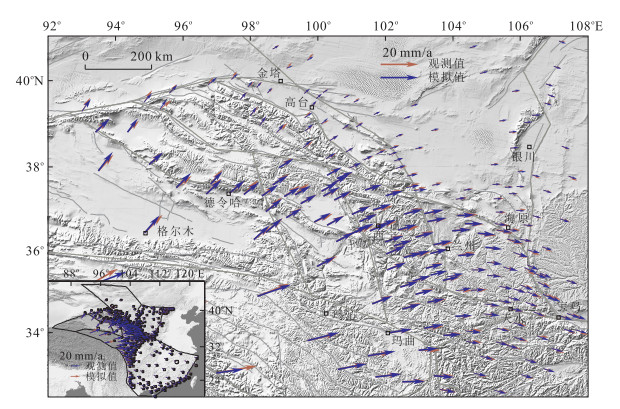
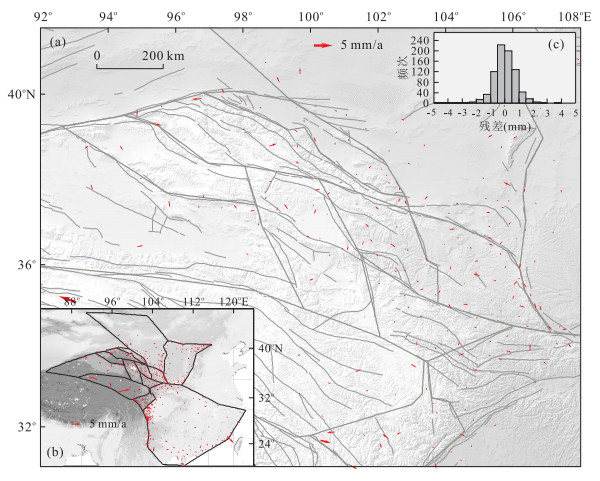
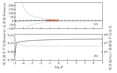
GPS mwasurements can provide a high accuracy of spatio-temporal images, but there aren't enough study about it. We use the spherical linear block theory constrained by geodetic observations from Global Positioning System (GPS) stations to estimate fault slip rates on the Northeastern margin of Tibet plateau and spatially variable coupling on Haiyuan fault in abroad sense. The 3D geometric block model is based on the previous researches of active block. The result provides a new constraint and reference for the geodynamics of present crustal deformation and the middle-long term strong earthquake hazard study in this area.
GPS mwasurements can provide a high accuracy of spatio-temporal images, but there aren't enough study about it. We use the spherical linear block theory constrained by geodetic observations from Global Positioning System (GPS) stations to estimate fault slip rates on the Northeastern margin of Tibet plateau and spatially variable coupling on Haiyuan fault in abroad sense. The 3D geometric block model is based on the previous researches of active block. The result provides a new constraint and reference for the geodynamics of present crustal deformation and the middle-long term strong earthquake hazard study in this area.