2015 Vol. 40, No. 12
Display Method:
 PDF 234KB
2015, 40(12): 1945-1954.
doi: 10.3799/dqkx.2015.175
Abstract:
Huangshan Loess makes a typical example of Northeast China's loess deposition, studying its genesis is the key to reconstruction of both paleoclimate and paleoenvironment of Northeast China. A high resolution and systematic grain size analysis is carried out on "Huangshan Loess" in Harbin area, and the origin of "Huangshan Loess" is discussed in this paper in comparison with many other types of sediment including the modern dust deposition in Harbin area, the loess-palaeosol distributed over the Loess Plateau, the fluvial sediment and Qidingshan Loess in Dalian. The results show that: the 10-50 μm partial group is the "dominant group" of the "Huangshan Loess" whereas the content of < 5 μm partials occupies 23.40%, which is more than the average content of > 50 μm and 5-10 μm particals, corresponding with the composition characteristic of typical eolian loess; The grain-size frequency distribution presents even-number peak and each of these features of grain size parameters are characterized by the atmospheric dust, the average of the σ, SK, KG, Kd, Mz, Md is 1.83, 0.21, 0.86, 2.01, 6.25φ, 5.89φ, respectively; Clay-silt-sand triangular plots of "Huangshan Loess" indicate that it belongs to clayey silt. C-M, L-M, A-M charts and statistical indices of grain size distribution share similarities with various aeolian sediments while obviously differ from fluvial sediments. No one discriminant analysis results is of positive value, which confirms that the "Huangshan Loess" is of the atmospheric sediment just like the aeolian origin of the loess-palaeosol in the Chinese plateau.
Huangshan Loess makes a typical example of Northeast China's loess deposition, studying its genesis is the key to reconstruction of both paleoclimate and paleoenvironment of Northeast China. A high resolution and systematic grain size analysis is carried out on "Huangshan Loess" in Harbin area, and the origin of "Huangshan Loess" is discussed in this paper in comparison with many other types of sediment including the modern dust deposition in Harbin area, the loess-palaeosol distributed over the Loess Plateau, the fluvial sediment and Qidingshan Loess in Dalian. The results show that: the 10-50 μm partial group is the "dominant group" of the "Huangshan Loess" whereas the content of < 5 μm partials occupies 23.40%, which is more than the average content of > 50 μm and 5-10 μm particals, corresponding with the composition characteristic of typical eolian loess; The grain-size frequency distribution presents even-number peak and each of these features of grain size parameters are characterized by the atmospheric dust, the average of the σ, SK, KG, Kd, Mz, Md is 1.83, 0.21, 0.86, 2.01, 6.25φ, 5.89φ, respectively; Clay-silt-sand triangular plots of "Huangshan Loess" indicate that it belongs to clayey silt. C-M, L-M, A-M charts and statistical indices of grain size distribution share similarities with various aeolian sediments while obviously differ from fluvial sediments. No one discriminant analysis results is of positive value, which confirms that the "Huangshan Loess" is of the atmospheric sediment just like the aeolian origin of the loess-palaeosol in the Chinese plateau.


2015, 40(12): 1955-1967.
doi: 10.3799/dqkx.2015.176
Abstract:
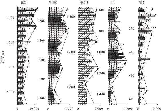
Paleoclimate is one of the main sedimentary dynamic factors for the formation of sequence stratigraphy of continental basin. The Paleogene-Neogene paleoclimate evolution in western sector of northern margin of Qaidam basin and surrounding areas was complex, but now paleoclimate evolution remains controversial. The elements, TOC and C, O stable isotope content of key well cores and rock debris were measured by geochemical methods. Correlation analysis between paleoclimate indicators shows that: Sr/Ba, Rb/Sr, Sr/Ca, TOC and chloride ion content can be the paleoclimate recovery indicators, however, δ13C and δ18O can't indicate the paleoclimate evolution process in the study area. Analysis of rock debris chloride ion data of key wells shows that the paleoclimate evolution process in the study area is arid-humid-arid. From Lulehe Formation to upper Shangganchaigou Formation, the paleoclimate gradually evolved from arid to humid climate, including 7 cycles, and lake water salinity decreased, the climate was humid and water was brackish overall. From Shangganchaigou Formation to Shizigou Formation, the paleoclimate evolved from humid to arid, including 12 cycles, and brackish water changed to medium brackish water.
Paleoclimate is one of the main sedimentary dynamic factors for the formation of sequence stratigraphy of continental basin. The Paleogene-Neogene paleoclimate evolution in western sector of northern margin of Qaidam basin and surrounding areas was complex, but now paleoclimate evolution remains controversial. The elements, TOC and C, O stable isotope content of key well cores and rock debris were measured by geochemical methods. Correlation analysis between paleoclimate indicators shows that: Sr/Ba, Rb/Sr, Sr/Ca, TOC and chloride ion content can be the paleoclimate recovery indicators, however, δ13C and δ18O can't indicate the paleoclimate evolution process in the study area. Analysis of rock debris chloride ion data of key wells shows that the paleoclimate evolution process in the study area is arid-humid-arid. From Lulehe Formation to upper Shangganchaigou Formation, the paleoclimate gradually evolved from arid to humid climate, including 7 cycles, and lake water salinity decreased, the climate was humid and water was brackish overall. From Shangganchaigou Formation to Shizigou Formation, the paleoclimate evolved from humid to arid, including 12 cycles, and brackish water changed to medium brackish water.


2015, 40(12): 1968-1986.
doi: 10.3799/dqkx.2015.177
Abstract:
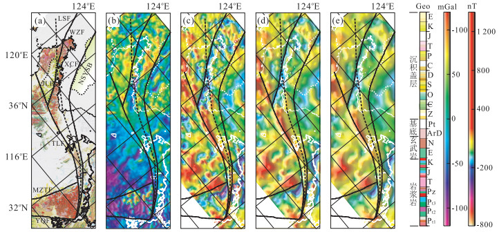
The Lower Yangtze region is an important area including hydrocarbon basins in eastern China, where Cenozoic tectonic deformation is the core of Cenozoic tectonic dynamics. In order to better understand the mechanism of extensional tectonics and the implications, the structure and framework of the Cenozoic fault basin in the Lower Yangtze region are studied. The regional basin structure reveals that the extensional structure is composed of a series of normal faults with totally arc-like changing strikes from NNE, to NE, and to NEE, displaying multidirectional extension and fault depression structure controlled by extensional fault system in the Lower Yangtze region, which can be divided into three extensional regions from south to north: Jiangnan extensional region, Yanjiang-Subei-South Yellow Sea extensional region, and northern South Yellow Sea extensional region. The numerical and structural physical simulations reveal that, subjected to the lateral tectonic stress triggered by the subduction of the Pacific plate beneath the Eurasian plate, the Lower Yangtze block moves laterally and extends regionally, and the Tan-Lu fault slips dextrally, which have formed a tectonic deformation system with dextral strike slip of Tan-Lu fault and lateral extension of Lower Yangtze block. Tectonically, Cenozoic extensional tectonics and formation mechanism of basins in the east of the Daxing'anling-Taihangshan-Wulingshan gravity lineament have been closely related to boundary condition of the Paleo-Pacific plate.
The Lower Yangtze region is an important area including hydrocarbon basins in eastern China, where Cenozoic tectonic deformation is the core of Cenozoic tectonic dynamics. In order to better understand the mechanism of extensional tectonics and the implications, the structure and framework of the Cenozoic fault basin in the Lower Yangtze region are studied. The regional basin structure reveals that the extensional structure is composed of a series of normal faults with totally arc-like changing strikes from NNE, to NE, and to NEE, displaying multidirectional extension and fault depression structure controlled by extensional fault system in the Lower Yangtze region, which can be divided into three extensional regions from south to north: Jiangnan extensional region, Yanjiang-Subei-South Yellow Sea extensional region, and northern South Yellow Sea extensional region. The numerical and structural physical simulations reveal that, subjected to the lateral tectonic stress triggered by the subduction of the Pacific plate beneath the Eurasian plate, the Lower Yangtze block moves laterally and extends regionally, and the Tan-Lu fault slips dextrally, which have formed a tectonic deformation system with dextral strike slip of Tan-Lu fault and lateral extension of Lower Yangtze block. Tectonically, Cenozoic extensional tectonics and formation mechanism of basins in the east of the Daxing'anling-Taihangshan-Wulingshan gravity lineament have been closely related to boundary condition of the Paleo-Pacific plate.


2015, 40(12): 1987-2001.
doi: 10.3799/dqkx.2015.178
Abstract:
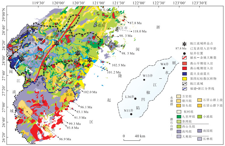
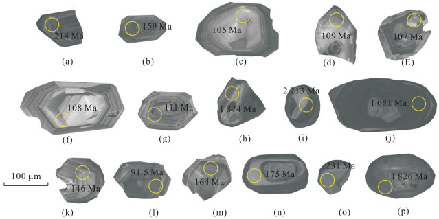
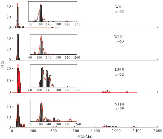
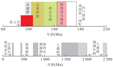
Sedimentary source has a significant impact on the development of oil and gas reservoir. To differentiate the provenance and analyze the lithological composition of the source area of the upper Mingyuefeng Formation in the west slope of Lishui-Jiaojiang sag, 4 detrital zircon samples from 4 drillings were selected for U-Pb isotopic dating, and then provenance analysis was conducted according to the dating results and the age and lithology of potential source. The results suggest that detrital zircons are mainly dominated by magmatic zircons falling into the age ranges of 125-90 Ma, 145-125 Ma and 170-145 Ma, and there are a small amount of metamorphic zircons aged 235-210 Ma and 2 087-1 653 Ma. In the potential source area, volcanic rocks in the age range of 168-94 Ma are in overwhelming majority, and metamorphic rocks older than 210 Ma and intrusive rocks formed in 107.0-87.8 Ma outcrop sporadically, while maybe there are sedimentary rocks of Yongkang Group concentrated locally. The comprehensive analysis shows that the provenance of the northeastern part of the study area was mainly volcanic-sedimentary rocks of Yongkang Group and volcanic of Jiuliping Formation and Late Cretaceous intrusions exposed locally. While in the southwestern part, the source rock was mainly Proterozoic metamorphic rocks and volcanic rocks from Xishantou Formation in addition to Jiuliping Formation, and a small amount of Jurassic volcanic rocks as well., which is more favorable to the development of high-quality reservoir in the southwestern part.
Sedimentary source has a significant impact on the development of oil and gas reservoir. To differentiate the provenance and analyze the lithological composition of the source area of the upper Mingyuefeng Formation in the west slope of Lishui-Jiaojiang sag, 4 detrital zircon samples from 4 drillings were selected for U-Pb isotopic dating, and then provenance analysis was conducted according to the dating results and the age and lithology of potential source. The results suggest that detrital zircons are mainly dominated by magmatic zircons falling into the age ranges of 125-90 Ma, 145-125 Ma and 170-145 Ma, and there are a small amount of metamorphic zircons aged 235-210 Ma and 2 087-1 653 Ma. In the potential source area, volcanic rocks in the age range of 168-94 Ma are in overwhelming majority, and metamorphic rocks older than 210 Ma and intrusive rocks formed in 107.0-87.8 Ma outcrop sporadically, while maybe there are sedimentary rocks of Yongkang Group concentrated locally. The comprehensive analysis shows that the provenance of the northeastern part of the study area was mainly volcanic-sedimentary rocks of Yongkang Group and volcanic of Jiuliping Formation and Late Cretaceous intrusions exposed locally. While in the southwestern part, the source rock was mainly Proterozoic metamorphic rocks and volcanic rocks from Xishantou Formation in addition to Jiuliping Formation, and a small amount of Jurassic volcanic rocks as well., which is more favorable to the development of high-quality reservoir in the southwestern part.


2015, 40(12): 2002-2020.
doi: 10.3799/dqkx.2015.179
Abstract:
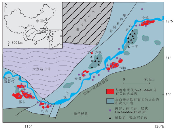
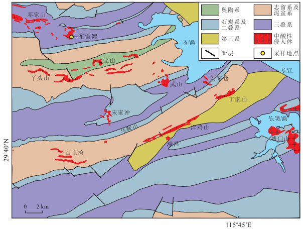
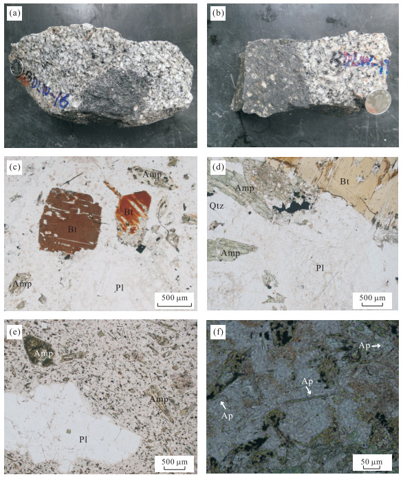
The intermediate-felsic intrusive rocks show a close relationship with mineralization in the Jiurui ore district, however, the studies of these rocks in the Dongleiwan deposit are relatively rare. In this study, we present a detailed study on zircon geochronology, mineral chemistry, whole rock geochemistry, and Sr-Nd-Pb-Hf isotopes of both the intermediate-felsic intrusive rocks and their mafic microgranular enclaves (MMEs). LA-ICP-MS zircon U-Pb dating yields crystallization ages of 144.3-148.7 Ma for the felsic rocks and 146.4-147.1 Ma for the MMEs, indicating they are coeval. All the intrusive rocks from the Dongleiwan deposit are metaluminous with high Mg# (42.5-68.0, with an average of 56.0) and high contents of compatible elements such as V, Cr, Co and Ni. The REE characteristics are LREE enriched and lack any significant Eu anomaly. The trace elements are characterized by enrichment of LILE and depletion of HFSE. The MMEs are characterized by microgranular texture, and contain acicular apatites and K-feldspar phenocrysts. The Dongleiwan rock samples have a narrow Sr-Nd isotopic ratio range with initial 87Sr/86Sr ratios from 0.706 4 to 0.707 9, εNd(t) values from -5.80 to -3.31, and t2DM(Nd) values from 1.2 to 1.4 Ga. The samples show radiogenic Pb isotopic ratios with values of 206Pb/204Pb(17.333 3-18.260 0), 207Pb/204Pb (15.513 5-15.621 0) and 208Pb/204Pb (37.404 1-38.395 4). The zircon Hf isotope analysis shows εHf(t) values of -15.9 to -3.6. These data suggest that the MMEs were probably produced by mixing of mafic and felsic magmas, and the mafic magma was derived from partial melting of delaminated lower crust and may have reacted with surrounded mantle peridotites during its ascent. While the felsic intrusive rocks of this area have been formed by the upwelling of magma which have experienced strong crust-mantle interaction after the delamination of lower crust into the asthenosphere.
The intermediate-felsic intrusive rocks show a close relationship with mineralization in the Jiurui ore district, however, the studies of these rocks in the Dongleiwan deposit are relatively rare. In this study, we present a detailed study on zircon geochronology, mineral chemistry, whole rock geochemistry, and Sr-Nd-Pb-Hf isotopes of both the intermediate-felsic intrusive rocks and their mafic microgranular enclaves (MMEs). LA-ICP-MS zircon U-Pb dating yields crystallization ages of 144.3-148.7 Ma for the felsic rocks and 146.4-147.1 Ma for the MMEs, indicating they are coeval. All the intrusive rocks from the Dongleiwan deposit are metaluminous with high Mg# (42.5-68.0, with an average of 56.0) and high contents of compatible elements such as V, Cr, Co and Ni. The REE characteristics are LREE enriched and lack any significant Eu anomaly. The trace elements are characterized by enrichment of LILE and depletion of HFSE. The MMEs are characterized by microgranular texture, and contain acicular apatites and K-feldspar phenocrysts. The Dongleiwan rock samples have a narrow Sr-Nd isotopic ratio range with initial 87Sr/86Sr ratios from 0.706 4 to 0.707 9, εNd(t) values from -5.80 to -3.31, and t2DM(Nd) values from 1.2 to 1.4 Ga. The samples show radiogenic Pb isotopic ratios with values of 206Pb/204Pb(17.333 3-18.260 0), 207Pb/204Pb (15.513 5-15.621 0) and 208Pb/204Pb (37.404 1-38.395 4). The zircon Hf isotope analysis shows εHf(t) values of -15.9 to -3.6. These data suggest that the MMEs were probably produced by mixing of mafic and felsic magmas, and the mafic magma was derived from partial melting of delaminated lower crust and may have reacted with surrounded mantle peridotites during its ascent. While the felsic intrusive rocks of this area have been formed by the upwelling of magma which have experienced strong crust-mantle interaction after the delamination of lower crust into the asthenosphere.


2015, 40(12): 2021-2036.
doi: 10.3799/dqkx.2015.180
Abstract:
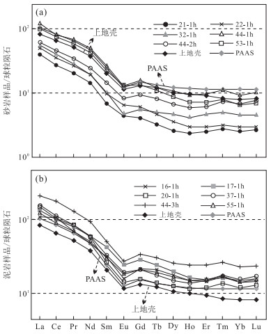
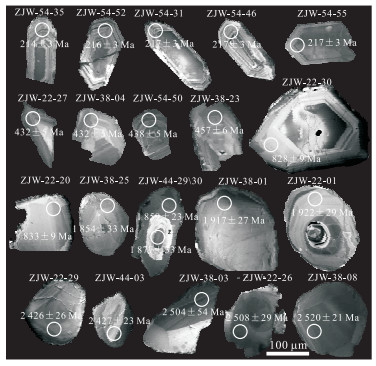
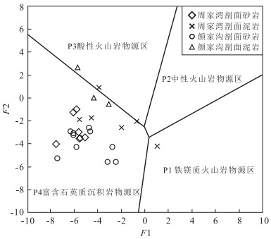
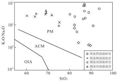
For revealing provenance and tectonic settings of Triassic Xujiahe Formation in Qiyueshan area, Southwest Hubei, detrital compositions, major, trace and rare earth elements, and zircon isotope ages of clastic rocks from Zhoujiawan and Yanjiagou sections were tested and analyzed. All sandstone samples are rich in quartz (Q), poor in lithic fragments (L) and feldspar (F), with an average of 76.15%, 8.90% and 3.45% respectively, Q/(Q+F+L) being averaged at 0.86, featuring with heavy mineral assemblage of zircon-brookite-magnetite-sphene-tourmaline, which suggests an acidic or low-grade metamorphic source. Dickinson discrimination diagrams show provenance mainly from recycled orogen. The sandstones are characterized by low (TFe2O3+MgO)* (1.3%, 1.5%, average for Zhoujiawan and Yanjiagou sections respectively), low TiO2* (0.37%, 0.39%), low Al2O3/SiO2 (0.10, 0.12) and high K2O/Na2O(4.89, 40.01), which are most similar to the characteristics of passive continental margin. The index of compositional variation (ICV: 0.32~0.79, average: 0.56) for mudstones implies the source materials are mainly recycled sediments. The REE patterns, contents and ratios of specific trace elements indicate passive and active continental margin settings during Late Triassic. Detrital zircons can be divided into rounded and euhedral categories. As recycled zircons mostly, rounded zircons (> 500 Ma, n=133) are characterized by "core-edge" or "core-mantle-edge" structure. Three prominent age peaks, i.e. 2 480 Ma, 1 880 Ma and 832 Ma are obtained, suggesting fingerprint of Yangtze craton. Having two prominent age peaks 435 Ma and 217 Ma, cylindrical euhedral zircons (< 500 Ma, n=42) with typical oscillatory zoning possess the characteristics of Xuefeng and Qinling orogens. Combined with provenance and tectonic discrimination diagrams, these characteristics all above suggest that Xujiahe Formation deposited in passive (main) and active continental margin, and its provenances were from Xuefeng orogenic belt (main source) and Qinling orogen.
For revealing provenance and tectonic settings of Triassic Xujiahe Formation in Qiyueshan area, Southwest Hubei, detrital compositions, major, trace and rare earth elements, and zircon isotope ages of clastic rocks from Zhoujiawan and Yanjiagou sections were tested and analyzed. All sandstone samples are rich in quartz (Q), poor in lithic fragments (L) and feldspar (F), with an average of 76.15%, 8.90% and 3.45% respectively, Q/(Q+F+L) being averaged at 0.86, featuring with heavy mineral assemblage of zircon-brookite-magnetite-sphene-tourmaline, which suggests an acidic or low-grade metamorphic source. Dickinson discrimination diagrams show provenance mainly from recycled orogen. The sandstones are characterized by low (TFe2O3+MgO)* (1.3%, 1.5%, average for Zhoujiawan and Yanjiagou sections respectively), low TiO2* (0.37%, 0.39%), low Al2O3/SiO2 (0.10, 0.12) and high K2O/Na2O(4.89, 40.01), which are most similar to the characteristics of passive continental margin. The index of compositional variation (ICV: 0.32~0.79, average: 0.56) for mudstones implies the source materials are mainly recycled sediments. The REE patterns, contents and ratios of specific trace elements indicate passive and active continental margin settings during Late Triassic. Detrital zircons can be divided into rounded and euhedral categories. As recycled zircons mostly, rounded zircons (> 500 Ma, n=133) are characterized by "core-edge" or "core-mantle-edge" structure. Three prominent age peaks, i.e. 2 480 Ma, 1 880 Ma and 832 Ma are obtained, suggesting fingerprint of Yangtze craton. Having two prominent age peaks 435 Ma and 217 Ma, cylindrical euhedral zircons (< 500 Ma, n=42) with typical oscillatory zoning possess the characteristics of Xuefeng and Qinling orogens. Combined with provenance and tectonic discrimination diagrams, these characteristics all above suggest that Xujiahe Formation deposited in passive (main) and active continental margin, and its provenances were from Xuefeng orogenic belt (main source) and Qinling orogen.


2015, 40(12): 2037-2051.
doi: 10.3799/dqkx.2015.181
Abstract:
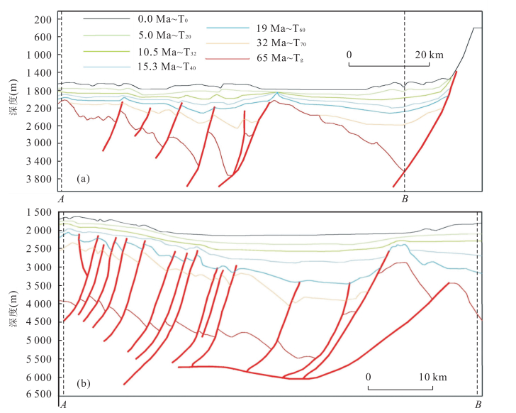
The formation and tectonic framework of a faulted basin are controlled by boundary fault, which have different types of basin evolution under different boundary connection modes. The purpose of this study is to recognize the linkage model of boundary faults of northern Huizhou sag in Zhu Ⅰ depression, Pearl River Mouth basin (PRMB), the South China Sea, which is a representative of global passive continental margin basins. Based on well controlling high-precision 3D seismic survey, the geometry of boundary faults and the framework of "four-order sequences" are determined in PRMB. The fault activities of different boundary fault sections and the spatial change of depocenters during rift episode Ⅰ are analyzed. An evolution model of boundary fault system in northern Huizhou sag, PRMB is established in this study. The results show that the northern bounding faults of northern Huizhou sag have an offset geometry in Early Eocene, characterized by along-strike and transverse two-way linkage. The along-strike linkage is a composite connection-transformation of "soft and hard" linkage, forming a relay ramp and transverse folds which restrict the structural evolution within Huizhou sag and the migration of its depocenters and sequences. The transverse linkage means the multiple-stage linkage of the transfer faults in relay ramp, including three stages, namely, isolated normal faulting, synthetic overlapping and hard linkage, which control the migration and distribution of depositional system within the relay ramp. This paper presents a unique case of spatial evolution, complex linkage and transformation model of boundary faults in a rift basin, which can facilitate further studies on the response relationship among the boundary fault, sedimentary sequence, sag evolution and regional dynamics mechanism.
The formation and tectonic framework of a faulted basin are controlled by boundary fault, which have different types of basin evolution under different boundary connection modes. The purpose of this study is to recognize the linkage model of boundary faults of northern Huizhou sag in Zhu Ⅰ depression, Pearl River Mouth basin (PRMB), the South China Sea, which is a representative of global passive continental margin basins. Based on well controlling high-precision 3D seismic survey, the geometry of boundary faults and the framework of "four-order sequences" are determined in PRMB. The fault activities of different boundary fault sections and the spatial change of depocenters during rift episode Ⅰ are analyzed. An evolution model of boundary fault system in northern Huizhou sag, PRMB is established in this study. The results show that the northern bounding faults of northern Huizhou sag have an offset geometry in Early Eocene, characterized by along-strike and transverse two-way linkage. The along-strike linkage is a composite connection-transformation of "soft and hard" linkage, forming a relay ramp and transverse folds which restrict the structural evolution within Huizhou sag and the migration of its depocenters and sequences. The transverse linkage means the multiple-stage linkage of the transfer faults in relay ramp, including three stages, namely, isolated normal faulting, synthetic overlapping and hard linkage, which control the migration and distribution of depositional system within the relay ramp. This paper presents a unique case of spatial evolution, complex linkage and transformation model of boundary faults in a rift basin, which can facilitate further studies on the response relationship among the boundary fault, sedimentary sequence, sag evolution and regional dynamics mechanism.


2015, 40(12): 2052-2066.
doi: 10.3799/dqkx.2015.182
Abstract:
In order to research the role of carbonate platform in the evolution of basin, the development of the carbonate platform and its correlation with the Cenozoic tectonic subsidence characteristics in the Reed Bank area in the southern South China Sea are explored in this study. The rate and amount of tectonic subsidence, and the tectonics are analyzed on the basis of two multi-channel seismic profiles across the Reed Bank area in NW-SE direction. Detailed seismic interpretations prove the occurrence of a wide distributed carbonate platform developed between the Late Oligocene to Early Miocene, which was submerged after the Middle Miocene. Reconstruction of the tectonic subsidence history shows that the tectonic subsidence was controlled by the tectonic activities in different periods, and could be divided into 5 episodes: the slow subsidence episode (Paleocene to Early Oligocene, rifting stage), the uplift and erosion episode (Late Oligocene to Early Miocene, drifting stage), the accelerating subsidence episode(the latest Early Miocene, post-drift stage 1), the intensive subsidence episode(Miocene, post-drift stage 2), and the steady subsidence episode (Late Miocene to present, post-rift stage 3). The development stage of the carbonate platform was consistent with the drifting stage of the South China Sea, during which the tectonic subsidence analysis suggests an uplift and erosion characteristics. This stable shallow water environment was favorable to the development of carbonates. During the drifting stage, large-scale mantle under the oceanic basin and the lateral temperature gradients under the continental margin might have triggered a secondary mantle convection under the rifted Reed Bank basin, resulting in the uplift and erosion activities in this stage, and the wide-development of carbonate platform.
In order to research the role of carbonate platform in the evolution of basin, the development of the carbonate platform and its correlation with the Cenozoic tectonic subsidence characteristics in the Reed Bank area in the southern South China Sea are explored in this study. The rate and amount of tectonic subsidence, and the tectonics are analyzed on the basis of two multi-channel seismic profiles across the Reed Bank area in NW-SE direction. Detailed seismic interpretations prove the occurrence of a wide distributed carbonate platform developed between the Late Oligocene to Early Miocene, which was submerged after the Middle Miocene. Reconstruction of the tectonic subsidence history shows that the tectonic subsidence was controlled by the tectonic activities in different periods, and could be divided into 5 episodes: the slow subsidence episode (Paleocene to Early Oligocene, rifting stage), the uplift and erosion episode (Late Oligocene to Early Miocene, drifting stage), the accelerating subsidence episode(the latest Early Miocene, post-drift stage 1), the intensive subsidence episode(Miocene, post-drift stage 2), and the steady subsidence episode (Late Miocene to present, post-rift stage 3). The development stage of the carbonate platform was consistent with the drifting stage of the South China Sea, during which the tectonic subsidence analysis suggests an uplift and erosion characteristics. This stable shallow water environment was favorable to the development of carbonates. During the drifting stage, large-scale mantle under the oceanic basin and the lateral temperature gradients under the continental margin might have triggered a secondary mantle convection under the rifted Reed Bank basin, resulting in the uplift and erosion activities in this stage, and the wide-development of carbonate platform.


2015, 40(12): 2067-2080.
doi: 10.3799/dqkx.2015.183
Abstract:
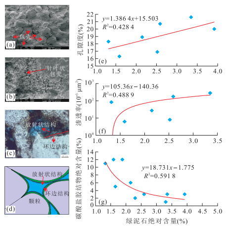
The genesis of high-quality reservoirs is the crucial problem to determine the effective exploration and development for the middle and deep burial reservoirs. This study focuses on the fan delta front reservoir in the lower part of the fourth member of the Shahejie Formation in Bonan subsag. Core and thin section observation, physical property testing and other technical methods were used to analyze the genetic mechanism of high-quality reservoirs of the fan delta front through drilling core, well logging and logging, three-dimension seismic and other materials. The results show that the properties of the reservoirs are mainly controlled by the original properties of different sedimentation facies, the types and influences of diagenesis, the strength and occurrence time of the overpressure and hydrocarbon charging, the fluid migration through fault or unconformity as well as the effect of evaporation. The development of high-quality reservoirs is the result of specific "source-fluid-sink" diagenesis system. Four factors determine the development of high-quality reservoirs. The first is the favorable sedimentary condition and the second is the favorable migration channels, such as fault, unconformity, high porosity and permeability reservoirs between reservoirs and source rocks. Thirdly, shorter migration path between reservoirs and source rocks, and besides, adequate source of fluid, hydrocarbon charging and formation overpressure are also important.
The genesis of high-quality reservoirs is the crucial problem to determine the effective exploration and development for the middle and deep burial reservoirs. This study focuses on the fan delta front reservoir in the lower part of the fourth member of the Shahejie Formation in Bonan subsag. Core and thin section observation, physical property testing and other technical methods were used to analyze the genetic mechanism of high-quality reservoirs of the fan delta front through drilling core, well logging and logging, three-dimension seismic and other materials. The results show that the properties of the reservoirs are mainly controlled by the original properties of different sedimentation facies, the types and influences of diagenesis, the strength and occurrence time of the overpressure and hydrocarbon charging, the fluid migration through fault or unconformity as well as the effect of evaporation. The development of high-quality reservoirs is the result of specific "source-fluid-sink" diagenesis system. Four factors determine the development of high-quality reservoirs. The first is the favorable sedimentary condition and the second is the favorable migration channels, such as fault, unconformity, high porosity and permeability reservoirs between reservoirs and source rocks. Thirdly, shorter migration path between reservoirs and source rocks, and besides, adequate source of fluid, hydrocarbon charging and formation overpressure are also important.


2015, 40(12): 2081-2090.
doi: 10.3799/dqkx.2015.184
Abstract:
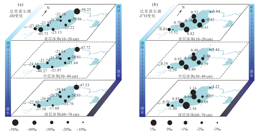
Utilizing the environmental isotopes, which exist widely as one proxy of lake water evolution process, has become one important direction in lake sciences.In this paper, a total of 77 samples of lake water, ice and precipitation water were collected in Dali-Nor Lake, which locates in cold-arid areas of Inner Mongolia; and changes of δD and δ18O and their responses to freezing process in Dali-Nor Lake are analyzed. The comparison of the changes of δD and δ18O among lake ice, lake water and precipitate water shows that: (1) Following the freezing process, the values of ΔδD, Δδ18O between bottom (65 cm) and surface (15 cm) ice layers are both above zero.But in fast stage and stable stage during lake ice forming, the change range of water stable isotopes is different.Meanwhile, the values of δD and δ18O in water under the ice are about 13.85 ‰ and 2.23 ‰ lighter than those in lake ice.In addition, the river inflows have more obvious influence on value changes of δD and δ18O among different sites in winter than in summer. (2) The δD and δ18O values of water (both summer and winter) and ice are both in right side of the global meteoric water line (GMWL) and local meteoric water line (LMWL), which shows that the evaporation process has certain influence on the fractional distillation of water stable isotopes before the lake ice formed. On the other hand, the values of δD and δ18O in lake ice and winter lake water have the same slope range and both in right side of the values of δD and δ18O in summer lake water, which shows that the freezing process has obvious influence on the fractional distillation of water stable isotopes during the lake ice forming process.
Utilizing the environmental isotopes, which exist widely as one proxy of lake water evolution process, has become one important direction in lake sciences.In this paper, a total of 77 samples of lake water, ice and precipitation water were collected in Dali-Nor Lake, which locates in cold-arid areas of Inner Mongolia; and changes of δD and δ18O and their responses to freezing process in Dali-Nor Lake are analyzed. The comparison of the changes of δD and δ18O among lake ice, lake water and precipitate water shows that: (1) Following the freezing process, the values of ΔδD, Δδ18O between bottom (65 cm) and surface (15 cm) ice layers are both above zero.But in fast stage and stable stage during lake ice forming, the change range of water stable isotopes is different.Meanwhile, the values of δD and δ18O in water under the ice are about 13.85 ‰ and 2.23 ‰ lighter than those in lake ice.In addition, the river inflows have more obvious influence on value changes of δD and δ18O among different sites in winter than in summer. (2) The δD and δ18O values of water (both summer and winter) and ice are both in right side of the global meteoric water line (GMWL) and local meteoric water line (LMWL), which shows that the evaporation process has certain influence on the fractional distillation of water stable isotopes before the lake ice formed. On the other hand, the values of δD and δ18O in lake ice and winter lake water have the same slope range and both in right side of the values of δD and δ18O in summer lake water, which shows that the freezing process has obvious influence on the fractional distillation of water stable isotopes during the lake ice forming process.


2015, 40(12): 2091-2102.
doi: 10.3799/dqkx.2015.185
Abstract:
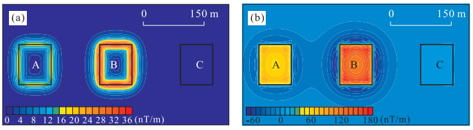
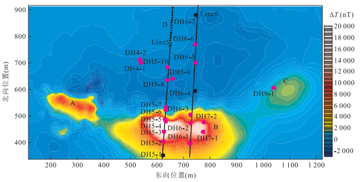
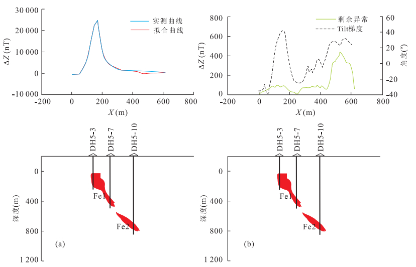
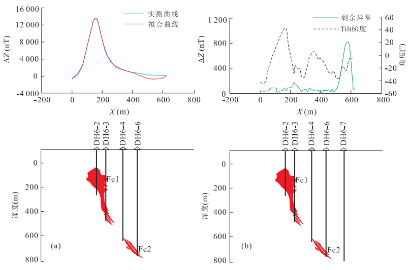
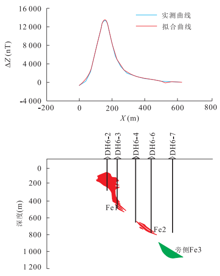
In order to slove the "singularity" problem of Tilt angle, an improved tilt angle method to detect the field source boundaries is proposed in this paper. Theoretical simulations reveal that improved Tilt angle method inherits the properties of the 1st order vertical derivative and traditional tilt gradient that identifies boundaries by zero value line and it is better for the deep weak anomalies identification than other methods such as the total module of horizontal gradient. Besides, the improved Tilt angle method avoids the abnormal degeneration due to its clear physical significance. Magnetic anomalies of the Weigang iron-ore deposit is analyzed and anomaly D is significantly enhanced except for three main anomalies of A, B, C, which indicates that the weak anomaly D is caused by deep concealed orebodies. The orebody depth is found as 1 000-1 200 m, based on the interactive inversion results of the 2.5 dimension. DH6-6 drilled hole is located in line 6, exactly on the east side of anomaly D, which coincides with the boring drilling of thin ore body. No-mine DH6-7 drilled hole is located at the outside of the weak anomaly area. It is possible that iron orebodies may be discovered if a drilled hole is arranged to the west and the north of Line 5.
In order to slove the "singularity" problem of Tilt angle, an improved tilt angle method to detect the field source boundaries is proposed in this paper. Theoretical simulations reveal that improved Tilt angle method inherits the properties of the 1st order vertical derivative and traditional tilt gradient that identifies boundaries by zero value line and it is better for the deep weak anomalies identification than other methods such as the total module of horizontal gradient. Besides, the improved Tilt angle method avoids the abnormal degeneration due to its clear physical significance. Magnetic anomalies of the Weigang iron-ore deposit is analyzed and anomaly D is significantly enhanced except for three main anomalies of A, B, C, which indicates that the weak anomaly D is caused by deep concealed orebodies. The orebody depth is found as 1 000-1 200 m, based on the interactive inversion results of the 2.5 dimension. DH6-6 drilled hole is located in line 6, exactly on the east side of anomaly D, which coincides with the boring drilling of thin ore body. No-mine DH6-7 drilled hole is located at the outside of the weak anomaly area. It is possible that iron orebodies may be discovered if a drilled hole is arranged to the west and the north of Line 5.


2015, 40(12): 2103-2109.
doi: 10.3799/dqkx.2015.186
Abstract:
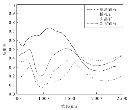
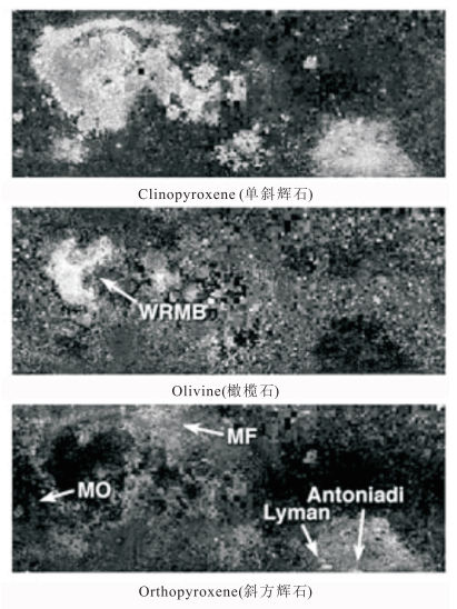
There are a variety of geological structures in the Oceanus Procellarum, including 43 craters, some famous lunar mares like Mare Imbrium and Mare Frigoris, and so on. Since the Oceanus Procellarum is the candidate landing area of lunar exploration for some countries, it is important to carry out the inversion of the minerals in the dark matter of craters of the area to facilitate research, exploration and utilization of lunar resources in the future. In addition, distribution of minerals on lunar surface is important since it concerns the origin and evolution of the moon. In this paper, the Oceanus Procellarum is taken as study area, the minerals in the dark matter of crater are inversed according to the spectra absorption characteristics in the visible and near-infrared bands of different minerals like clinopyroxene, orthopyroxene, olivine and spinel from M3 (moon mineralogy mapper) data by spectral feature fitting. The mafic minerals extracted from the Oceanus Procellarum are relatively concentrated. The content of pyroxene is more than spinel and olivine. And the geological significance and relationship among olivine, spinel and other extracted minerals in the vicinity are analyzed. A comparison of the mapping results of the optical model of Lucey on Clementine data reveals that the distribution of inversion results is consistent. In this paper, the extracted olivine distributed concentratively, but there is no large scale distribution, it is associated with the study area of this article.
There are a variety of geological structures in the Oceanus Procellarum, including 43 craters, some famous lunar mares like Mare Imbrium and Mare Frigoris, and so on. Since the Oceanus Procellarum is the candidate landing area of lunar exploration for some countries, it is important to carry out the inversion of the minerals in the dark matter of craters of the area to facilitate research, exploration and utilization of lunar resources in the future. In addition, distribution of minerals on lunar surface is important since it concerns the origin and evolution of the moon. In this paper, the Oceanus Procellarum is taken as study area, the minerals in the dark matter of crater are inversed according to the spectra absorption characteristics in the visible and near-infrared bands of different minerals like clinopyroxene, orthopyroxene, olivine and spinel from M3 (moon mineralogy mapper) data by spectral feature fitting. The mafic minerals extracted from the Oceanus Procellarum are relatively concentrated. The content of pyroxene is more than spinel and olivine. And the geological significance and relationship among olivine, spinel and other extracted minerals in the vicinity are analyzed. A comparison of the mapping results of the optical model of Lucey on Clementine data reveals that the distribution of inversion results is consistent. In this paper, the extracted olivine distributed concentratively, but there is no large scale distribution, it is associated with the study area of this article.


2015, 40(12): 2110-2118.
doi: 10.3799/dqkx.2015.187
Abstract:
At present, borehole magnetic gradient is one of the commonly used methods for the detection of deeply buried metal pipelines, which is controversial due to its unsystematic theoretic basis and absence of quantitative analysis. In view of these challenges, this paper aims to present our study involving the following three aspects. (1) The relationships of the vertical component, horizontal component between the magnetic fields of surface and boreholes were derived, and the borehole magnetic gradient formula of deep underground pipeline was deduced, starting from the strength of the magnetic field of infinite horizontal cylinder and the transformation of coordinate system. (2) The relationship of the magnetic gradient changes with the inclination of effective magnetization and the position of hole was simulated according to the formula of magnetic gradient. (3) Three kinds of relationship were determined based on the statistical analysis of the forward modeling data, namely, (a) the relationship between maximum ratio of magnetic gradient and the inclination of magnetic gradient, (b) the relationship of the horizontal position of deep underground pipelines, the extreme distance of magnetic gradient and the inclination of magnetic gradient, (c) the relationship of the ratio of distance between the depth of deep underground pipelines, the depth corresponding to the maximum absolute value of magnetic gradient, the extreme distance of magnetic gradient with the inclination of magnetic gradient. These relationships constitute the estimation formula to estimate the depth and horizontal position of deep underground pipelines. Finally, an example of estimating the depth and horizontal position of deep underground pipeline is given. The feasibility of the method is shown by the results of forward modeling based on the estimation results.
At present, borehole magnetic gradient is one of the commonly used methods for the detection of deeply buried metal pipelines, which is controversial due to its unsystematic theoretic basis and absence of quantitative analysis. In view of these challenges, this paper aims to present our study involving the following three aspects. (1) The relationships of the vertical component, horizontal component between the magnetic fields of surface and boreholes were derived, and the borehole magnetic gradient formula of deep underground pipeline was deduced, starting from the strength of the magnetic field of infinite horizontal cylinder and the transformation of coordinate system. (2) The relationship of the magnetic gradient changes with the inclination of effective magnetization and the position of hole was simulated according to the formula of magnetic gradient. (3) Three kinds of relationship were determined based on the statistical analysis of the forward modeling data, namely, (a) the relationship between maximum ratio of magnetic gradient and the inclination of magnetic gradient, (b) the relationship of the horizontal position of deep underground pipelines, the extreme distance of magnetic gradient and the inclination of magnetic gradient, (c) the relationship of the ratio of distance between the depth of deep underground pipelines, the depth corresponding to the maximum absolute value of magnetic gradient, the extreme distance of magnetic gradient with the inclination of magnetic gradient. These relationships constitute the estimation formula to estimate the depth and horizontal position of deep underground pipelines. Finally, an example of estimating the depth and horizontal position of deep underground pipeline is given. The feasibility of the method is shown by the results of forward modeling based on the estimation results.


2015, 40(12): 2119-2124.
doi: 10.3799/dqkx.2015.188
Abstract:
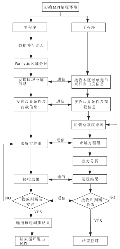
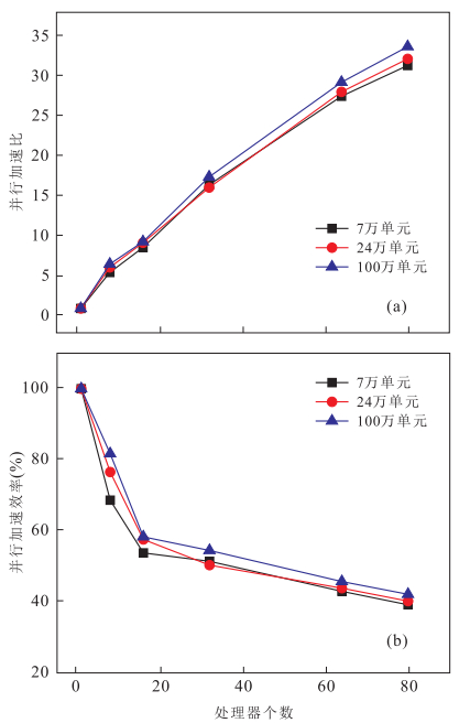
With the expansion of the scale of geotechnical engineering, the increase of the complexity and diversity of the calculation parameters and the improvement of calculation accuracy, the requirement of computer computing power is higher, but a single processor can't meet this kind of large-scale computing.Key issues involving the data input, domain decomposition technique, iteration solution algorithm of linear system, and post processing for large scale geotechnical engineering using parallel finite element method based on high performance computation platform are presented in this paper. The study includes a case analysis of a tunnel evacuation in the following procedure. A new feature was employed so that massive data can be read in parallel, and parallel software, i.e. ParMetis was used to decompose the domain, then the pre-process was in completely parallel. The preconditioned conjugate gradient method based on Jacobi preconditioner was applied to solve linear system. In post processing, the parallel visual model was obtained through the Paraview software. A 3D tunnel excavation was simulated in DeepComp 7000 system, on basis of which the parallel performance is analyzed and evaluated, Verified by domain decomposition algorithm and the feasibility of the method of solving the system equations, and has high speedup ratio and parallel efficiency.
With the expansion of the scale of geotechnical engineering, the increase of the complexity and diversity of the calculation parameters and the improvement of calculation accuracy, the requirement of computer computing power is higher, but a single processor can't meet this kind of large-scale computing.Key issues involving the data input, domain decomposition technique, iteration solution algorithm of linear system, and post processing for large scale geotechnical engineering using parallel finite element method based on high performance computation platform are presented in this paper. The study includes a case analysis of a tunnel evacuation in the following procedure. A new feature was employed so that massive data can be read in parallel, and parallel software, i.e. ParMetis was used to decompose the domain, then the pre-process was in completely parallel. The preconditioned conjugate gradient method based on Jacobi preconditioner was applied to solve linear system. In post processing, the parallel visual model was obtained through the Paraview software. A 3D tunnel excavation was simulated in DeepComp 7000 system, on basis of which the parallel performance is analyzed and evaluated, Verified by domain decomposition algorithm and the feasibility of the method of solving the system equations, and has high speedup ratio and parallel efficiency.