


2015 Vol. 40, No. 3
Display Method:
2015, 40(3): 397-406.
doi: 10.3799/dqkx.2015.031
 PDF 1698KB
Abstract:
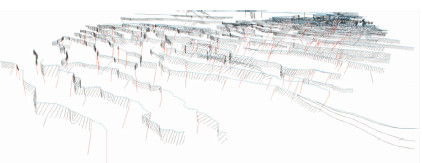
Three-dimensional geological mapping is a pioneering job in frontiers without much experience. It is far more challenging to work out three-dimensional geological structure in a square area with certain scale for complex orogenic and metallogenic belts, where geophysical and drilling data are relatively limited. In this paper, we put forward a framework of the three-dimensional geological mapping and visualization for bedrocks of orogenic belts based on our three-dimensional geological mapping practice in the northwest Karamay, western Junggar. We emphasize that the basic data involved in visual modeling for a certain square area and scale are primarily based on the network of systematic surface geological sections and then the extension for the deep geological bodies which are based on geological-geophysical-drilling united constraints. With the combination of surface geological sections and geophysical/drilling data, three-climension geological texture from surface to certain depths at a certain confidence level can be traced. That is to say that three-dimensional numerical models of geological structures can be constructed by utilizing the rich data of classical "surface regional geological mapping" with the combination of geophysical/drilling data.
Three-dimensional geological mapping is a pioneering job in frontiers without much experience. It is far more challenging to work out three-dimensional geological structure in a square area with certain scale for complex orogenic and metallogenic belts, where geophysical and drilling data are relatively limited. In this paper, we put forward a framework of the three-dimensional geological mapping and visualization for bedrocks of orogenic belts based on our three-dimensional geological mapping practice in the northwest Karamay, western Junggar. We emphasize that the basic data involved in visual modeling for a certain square area and scale are primarily based on the network of systematic surface geological sections and then the extension for the deep geological bodies which are based on geological-geophysical-drilling united constraints. With the combination of surface geological sections and geophysical/drilling data, three-climension geological texture from surface to certain depths at a certain confidence level can be traced. That is to say that three-dimensional numerical models of geological structures can be constructed by utilizing the rich data of classical "surface regional geological mapping" with the combination of geophysical/drilling data.


2015, 40(3): 407-418, 424.
doi: 10.3799/dqkx.2015.032
Abstract:
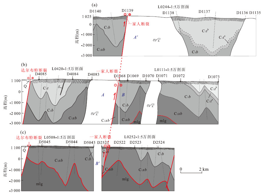
Three-dimensional geological mapping in the complicated orogenic belts is still in the testing stage due to inadequate geophysical and drill-hole data in the region. In this paper, we propose a method of three-dimensional geological modelling by using the measured natural profiles and the geophysical profiles under the constraints of detailed surface geological investigation data and the geology-geophysics-drilling data. The modelling reliability is evaluated based on the accuracy of the data and the spatial resolution. The surface structures are constrained by the surface geological information, including the attitudes, stratigraphic sequence and thickness, fold morphology, fault feature, and the local and regional conceptual geological models. The deep geological structures are mainly based on the geophysical profile data, in combination with proper drilling data which act as not only a test of the reliability of the geophysical interpretation but also an enhancement of the model. This paper takes the three-dimensional geological mapping of the Houshan area in Karamay as an example and discusses the detailed procedure in realizing the above-mentioned scheme, which shows both high efficiency and operability.
Three-dimensional geological mapping in the complicated orogenic belts is still in the testing stage due to inadequate geophysical and drill-hole data in the region. In this paper, we propose a method of three-dimensional geological modelling by using the measured natural profiles and the geophysical profiles under the constraints of detailed surface geological investigation data and the geology-geophysics-drilling data. The modelling reliability is evaluated based on the accuracy of the data and the spatial resolution. The surface structures are constrained by the surface geological information, including the attitudes, stratigraphic sequence and thickness, fold morphology, fault feature, and the local and regional conceptual geological models. The deep geological structures are mainly based on the geophysical profile data, in combination with proper drilling data which act as not only a test of the reliability of the geophysical interpretation but also an enhancement of the model. This paper takes the three-dimensional geological mapping of the Houshan area in Karamay as an example and discusses the detailed procedure in realizing the above-mentioned scheme, which shows both high efficiency and operability.


2015, 40(3): 419-424.
doi: 10.3799/dqkx.2015.033
Abstract:
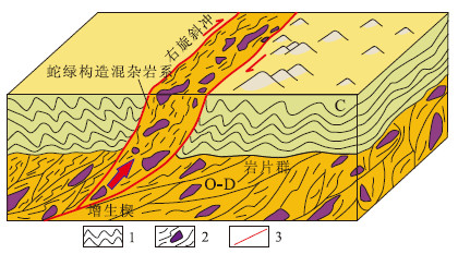
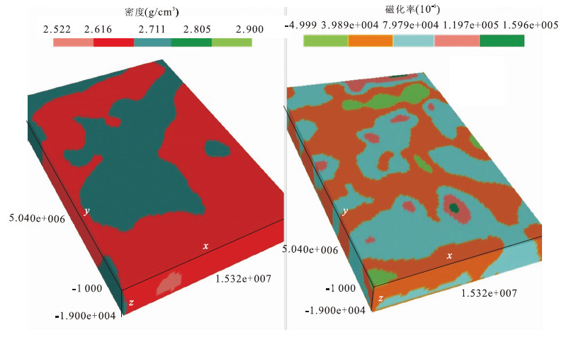
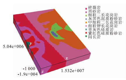
Inadequate geological sampling information is a major constraint for 3D geological modeling of the deep geological body. Since it is relatively easier to acquire the deep geophysical data, the visualization model of the geophysical data can be formed effectively. In this study, a 3D geological modeling method by the geophysical data collected in the geological survey is proposed. It involves firstly extracting the mapping function from geophysical data to the geological property by geophysical experiment on the samples, and then integrating the visualization models constructed from multi-source geophysical data for interpretation, and finally converting the interpreted visualization model to the 3D geological model. The method proves feasible for solutions on 3D modeling concerning deep geological bodies in the project.
Inadequate geological sampling information is a major constraint for 3D geological modeling of the deep geological body. Since it is relatively easier to acquire the deep geophysical data, the visualization model of the geophysical data can be formed effectively. In this study, a 3D geological modeling method by the geophysical data collected in the geological survey is proposed. It involves firstly extracting the mapping function from geophysical data to the geological property by geophysical experiment on the samples, and then integrating the visualization models constructed from multi-source geophysical data for interpretation, and finally converting the interpreted visualization model to the 3D geological model. The method proves feasible for solutions on 3D modeling concerning deep geological bodies in the project.


2015, 40(3): 425-430.
doi: 10.3799/dqkx.2015.034
Abstract:
The structure and access interfaces of data are designed by reference to external schema changes in traditional management and application of geological data, for which application programs have to be modified in case of any external schema changes, even if there are not much variations in business logic. To tackle the issue, control dictionary tables are proposed in this study by analyzing the characteristics of different geological attribute data and generalizing external schema of geological databases based on view mechanism of relation databases, which is used in character-set formed from determinant attributes needed for geological business analysis and evaluation. Meanwhile, data access interfaces are designed according to the data structures of the control dictionary tables which abstract the object-oriented data model of geological professions and map the relation between the data model and geological data. It is shown that it is only necessary to modify the mapping relations between control dictionary and external schema rather than applications to realize the expansion of geological databases dynamically, in which the control dictionary separates the operation of geological data by users and from the processing by computers as a middleware, thus ensuring the logic independence of program and data layers.
The structure and access interfaces of data are designed by reference to external schema changes in traditional management and application of geological data, for which application programs have to be modified in case of any external schema changes, even if there are not much variations in business logic. To tackle the issue, control dictionary tables are proposed in this study by analyzing the characteristics of different geological attribute data and generalizing external schema of geological databases based on view mechanism of relation databases, which is used in character-set formed from determinant attributes needed for geological business analysis and evaluation. Meanwhile, data access interfaces are designed according to the data structures of the control dictionary tables which abstract the object-oriented data model of geological professions and map the relation between the data model and geological data. It is shown that it is only necessary to modify the mapping relations between control dictionary and external schema rather than applications to realize the expansion of geological databases dynamically, in which the control dictionary separates the operation of geological data by users and from the processing by computers as a middleware, thus ensuring the logic independence of program and data layers.


2015, 40(3): 431-440.
doi: 10.3799/dqkx.2015.035
Abstract:
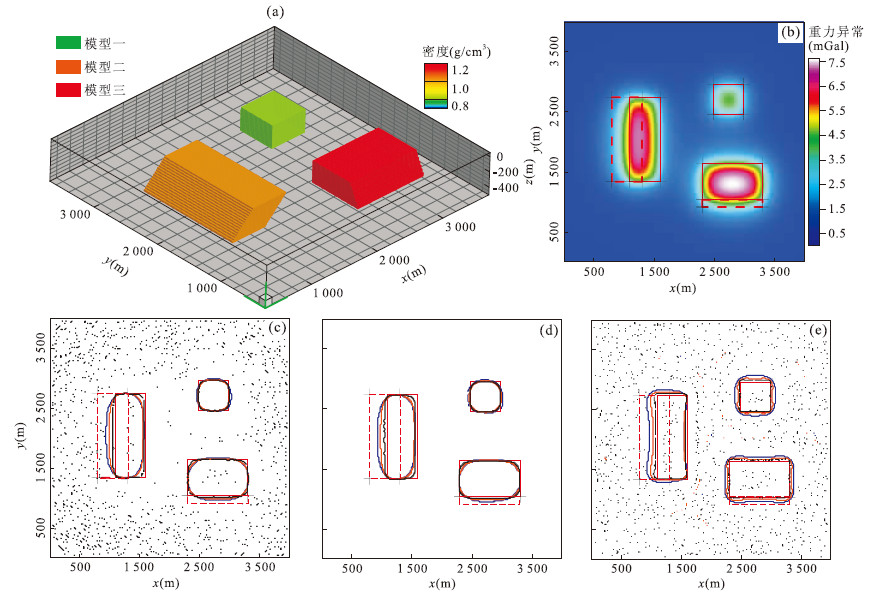
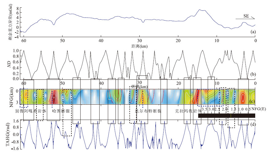
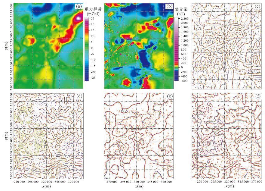
In this paper, four edge-detection methods including normalized deviation (ND) method, a new one proposed by us, are studied for their applications in 3-D mapping. The ND method is featured with low sensitivity to the noise, high accuracy and detailed results. On the basis of the theoretical framework of these methods, we tested their accuracy with synthetic models and gained more information of the geological boundaries by the combination of different methods and edge detecting on multi-scale, which shows good performance. Then we used them in field data of the Karamay back mountain area to get the distribution of faults and rock masses, strikes and depths. The spatial features of some major faults and rock masses are described, which delivers useful information for the 3-D geological mapping of the study area.
In this paper, four edge-detection methods including normalized deviation (ND) method, a new one proposed by us, are studied for their applications in 3-D mapping. The ND method is featured with low sensitivity to the noise, high accuracy and detailed results. On the basis of the theoretical framework of these methods, we tested their accuracy with synthetic models and gained more information of the geological boundaries by the combination of different methods and edge detecting on multi-scale, which shows good performance. Then we used them in field data of the Karamay back mountain area to get the distribution of faults and rock masses, strikes and depths. The spatial features of some major faults and rock masses are described, which delivers useful information for the 3-D geological mapping of the study area.


2015, 40(3): 441-447.
doi: 10.3799/dqkx.2015.036
Abstract:
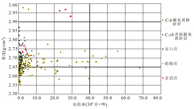
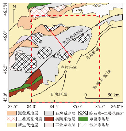
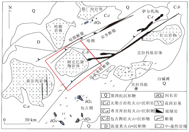
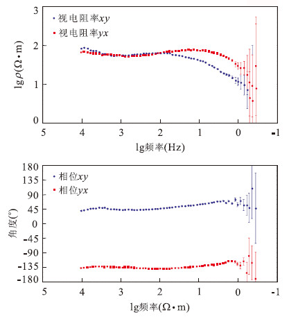
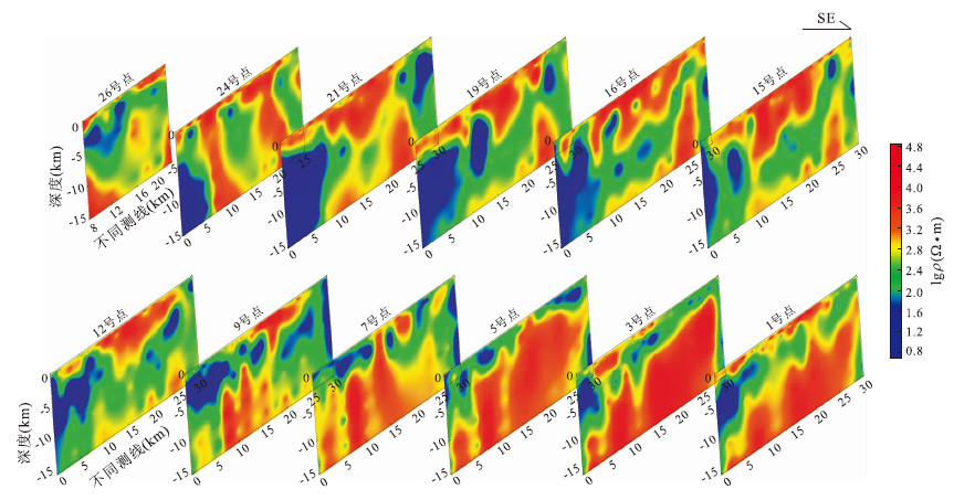
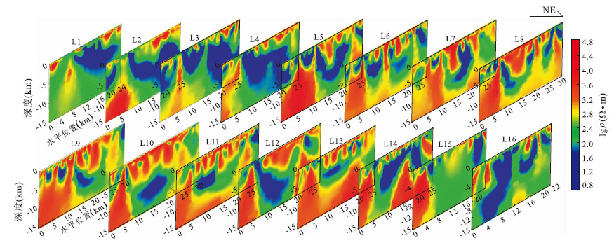
To investigate three-dimensional electrical features of Akebasitao rock mass and the structure of Darbut fault, we used audio magnetotelluric sounding for geological mapping exploration of three-dimensional nature in the region and display the results of the two-dimensional Occam inversion in three dimensions. The results indicate that there are two magma channels in southeast and northwest parts in two sides of Darbut fault. The southeast intrusive rock mass is large in size and only partly connected to Akebasitao rock mass since it was cut by Darbut fault. The magma channel in northwest is directly connected to rock mass as a reverse cone pyramid which is larger in shadow part and getting smaller in the deep, which resulted from the magma intrusion into the middle of the survey area. The rock mass can be 7-8 km deep in the middle part and there are low resistance materials below the rock mass. It is concluded that Darbut fault in this area strikes northeast-southwest to northwest, with big inclination angle, as steep as 5 to 10 km and the lower part of fault is connected to the low resistance material below the rock mass.
To investigate three-dimensional electrical features of Akebasitao rock mass and the structure of Darbut fault, we used audio magnetotelluric sounding for geological mapping exploration of three-dimensional nature in the region and display the results of the two-dimensional Occam inversion in three dimensions. The results indicate that there are two magma channels in southeast and northwest parts in two sides of Darbut fault. The southeast intrusive rock mass is large in size and only partly connected to Akebasitao rock mass since it was cut by Darbut fault. The magma channel in northwest is directly connected to rock mass as a reverse cone pyramid which is larger in shadow part and getting smaller in the deep, which resulted from the magma intrusion into the middle of the survey area. The rock mass can be 7-8 km deep in the middle part and there are low resistance materials below the rock mass. It is concluded that Darbut fault in this area strikes northeast-southwest to northwest, with big inclination angle, as steep as 5 to 10 km and the lower part of fault is connected to the low resistance material below the rock mass.


2015, 40(3): 448-460,503.
doi: 10.3799/dqkx.2015.037
Abstract:
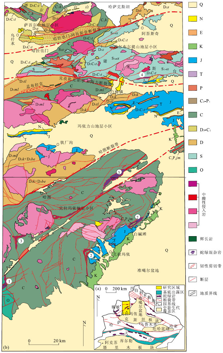
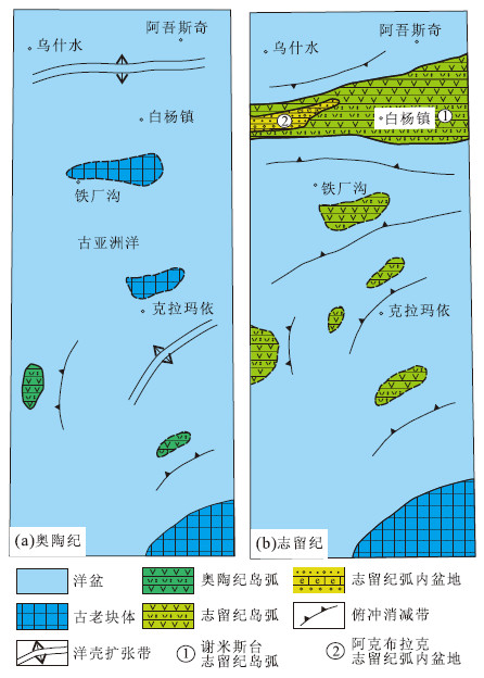
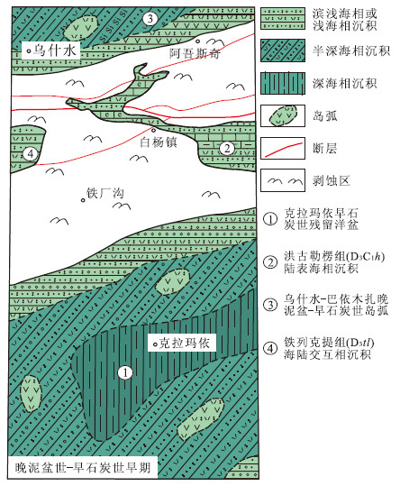
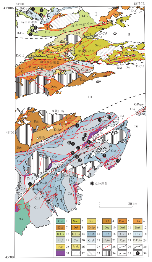
Paleozoic substance formations are widespread in Karamay-Emin area of western Junggar in Xinjiang, recording evolution information of Paleo-Asian Ocean. During Paleozoic, and especially the Late Paleozoic, this region has experienced a complex ocean-land transition process. Thus, a series of ophiolitic mélanges with nearly east-west and northeastern trends, and subduction-accretionary complexes of the ancient continental margin have been developed, resulting in the complicated rock formation system in the study area. To better probe into the ancient geographical attributes and structural framework between Silurian and Devonian in western Junggar, we define the tectonic paleogeographic properties of Silurian and Devonian in Karamay-Emin area and discuss arc-basin tectonic framework from Silurian to Devonian in western Junggar based on geological survey and relevant data in this study. The authors suggest that Paleo-Asian Ocean in the Karamay-Emin area began intense subducting in Silurian and widely subduction-collage stage with archipelago arc-basin system in Devonian. Paleo-Asian Ocean along the Karamay-Emin area started its residual oceanic basin evolutionary stage after Devonian.
Paleozoic substance formations are widespread in Karamay-Emin area of western Junggar in Xinjiang, recording evolution information of Paleo-Asian Ocean. During Paleozoic, and especially the Late Paleozoic, this region has experienced a complex ocean-land transition process. Thus, a series of ophiolitic mélanges with nearly east-west and northeastern trends, and subduction-accretionary complexes of the ancient continental margin have been developed, resulting in the complicated rock formation system in the study area. To better probe into the ancient geographical attributes and structural framework between Silurian and Devonian in western Junggar, we define the tectonic paleogeographic properties of Silurian and Devonian in Karamay-Emin area and discuss arc-basin tectonic framework from Silurian to Devonian in western Junggar based on geological survey and relevant data in this study. The authors suggest that Paleo-Asian Ocean in the Karamay-Emin area began intense subducting in Silurian and widely subduction-collage stage with archipelago arc-basin system in Devonian. Paleo-Asian Ocean along the Karamay-Emin area started its residual oceanic basin evolutionary stage after Devonian.


2015, 40(3): 461-484.
doi: 10.3799/dqkx.2015.038
Abstract:
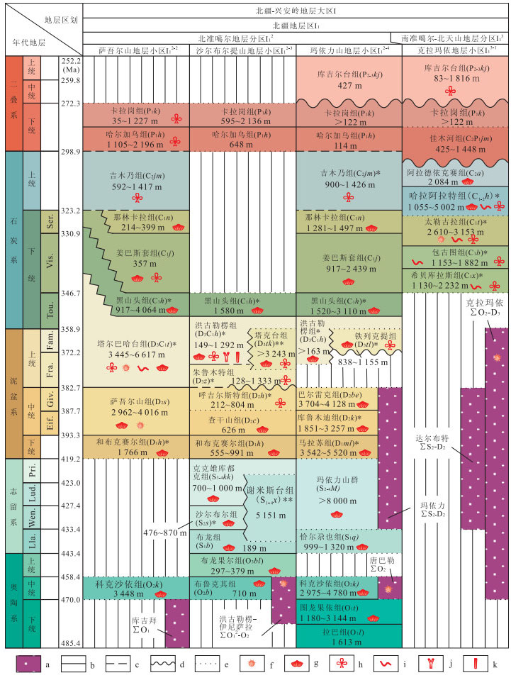
Both general and special stratigraphic regionalizations have been worked out in this study according to (1) geotectonic environments and sedimentary association types; (2) stratigraphic sequences and contact relationships; (3) paleogeographic framework and paleoenvironmental conditions; (4) paleontological taxa and paleobiogeography; (5) deformational and metamorphic specialty of strata, as well as (6) boundary types of stratigraphic regionalization and their criterion. Both general and special stratigraphic regionalizations can be subdivided into four hierarchies of the stratomegaregion, stratoregion, stratosubregion, and stratomicroregion. The Paleozoic strata of western Junggar can be divided into four stratomicroregions from north to south, i. e. the Saur Mountains, Shaerbuerti Mountains, Mayili Mountains and Karamay stratomicroregions based on the mentioned-above six aspects, and new data and progresses gained in recent studies. Paleozoic western Junggar is featured by its archipelagic ocean and soft-collisional orogenics in tectonopaleogeography. The Late Silurian till Early Carboniferous represents the prime of such tectonic pattern and regimes, forming the Paleozoic stratigraphic regionalization. Western Junggar emerged from ocean and stepped into an intracontinental orogenic period from the Late Carboniferous to Permian, announcing a gradual disappearance of stratigraphic regionalization. In paleobiogeography, the Early Paleozoic of western Junggar is distinguished by its mixed fauna between the Pacific and Atlantic biomegaprovinces, and also different from the bioprovince represented by the Tuvaella fauna in the southern part of the Siberian plate. The fossil assemblages of western Junggar during the Silurian to Devonian periods show a prominent relevance to the tropical-subtropical palaeo-tethys biomegaprovince.However, an Angara flora typical of the north temperate zone dominates the Late Carboniferous to Permian continental strata in western Junggar. In sedimentary paleogeography, the processing facies of Paleozoic western Junggar include both normal and event sedimentary facies, with the latter particularly developed such as volcanic eruption, volcanic overflow and seismite facies, which reflects its active tectonic background. The environmental facies comprise palaeo-continental, fluvial, littoral-shallow-marine and bathyal-abyssal facies.
Both general and special stratigraphic regionalizations have been worked out in this study according to (1) geotectonic environments and sedimentary association types; (2) stratigraphic sequences and contact relationships; (3) paleogeographic framework and paleoenvironmental conditions; (4) paleontological taxa and paleobiogeography; (5) deformational and metamorphic specialty of strata, as well as (6) boundary types of stratigraphic regionalization and their criterion. Both general and special stratigraphic regionalizations can be subdivided into four hierarchies of the stratomegaregion, stratoregion, stratosubregion, and stratomicroregion. The Paleozoic strata of western Junggar can be divided into four stratomicroregions from north to south, i. e. the Saur Mountains, Shaerbuerti Mountains, Mayili Mountains and Karamay stratomicroregions based on the mentioned-above six aspects, and new data and progresses gained in recent studies. Paleozoic western Junggar is featured by its archipelagic ocean and soft-collisional orogenics in tectonopaleogeography. The Late Silurian till Early Carboniferous represents the prime of such tectonic pattern and regimes, forming the Paleozoic stratigraphic regionalization. Western Junggar emerged from ocean and stepped into an intracontinental orogenic period from the Late Carboniferous to Permian, announcing a gradual disappearance of stratigraphic regionalization. In paleobiogeography, the Early Paleozoic of western Junggar is distinguished by its mixed fauna between the Pacific and Atlantic biomegaprovinces, and also different from the bioprovince represented by the Tuvaella fauna in the southern part of the Siberian plate. The fossil assemblages of western Junggar during the Silurian to Devonian periods show a prominent relevance to the tropical-subtropical palaeo-tethys biomegaprovince.However, an Angara flora typical of the north temperate zone dominates the Late Carboniferous to Permian continental strata in western Junggar. In sedimentary paleogeography, the processing facies of Paleozoic western Junggar include both normal and event sedimentary facies, with the latter particularly developed such as volcanic eruption, volcanic overflow and seismite facies, which reflects its active tectonic background. The environmental facies comprise palaeo-continental, fluvial, littoral-shallow-marine and bathyal-abyssal facies.


2015, 40(3): 485-503.
doi: 10.3799/dqkx.2015.039
Abstract:
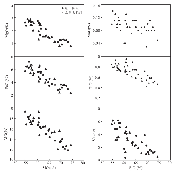
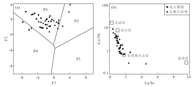
The geochemistry and detrital zircon characteristics of the sediments play an important role in the study of sedimentary provenance and their tectonic settings. This paper presents petrography and geochemical study of the Early Carboniferous Baogutu Group and Tailegula Group clastic rocks in Karamay area, western Junggar, NW Xinjiang. Geochemical data show that the sedimentary rocks have SiO2 contents (54.64%-73.14%), relatively high Al2O3 contents (11.89%-19.36%) and high (TFe2O3+MgO) contents (3.97%-9.99%), indicating low chemical maturity. Their total rare earth element contents vary between 83×10-6 and 252×10-6, characterized by no Ce anomaly and slightly negative Eu anomalies, which is similar to those of sandstones formed at oceanic island arc setting. U-Pb dating results of detrital zircons show that Baogutu Group has 340 and 440 Ma two peak values. Detrital zircons of Tailegula Group show only one peak (325 Ma) and suggests that they were sourced from the Early Carboniferous rocks. Discrimination diagrams of the major and trace elements show that the provenance and tectonic settings of Early Carboniferous Baogutu and Tailegula groups sedimentary rocks were formed from the oceanic island arc and continental island arc acidic volcanic rocks, with minor mafic volcanic rocks.
The geochemistry and detrital zircon characteristics of the sediments play an important role in the study of sedimentary provenance and their tectonic settings. This paper presents petrography and geochemical study of the Early Carboniferous Baogutu Group and Tailegula Group clastic rocks in Karamay area, western Junggar, NW Xinjiang. Geochemical data show that the sedimentary rocks have SiO2 contents (54.64%-73.14%), relatively high Al2O3 contents (11.89%-19.36%) and high (TFe2O3+MgO) contents (3.97%-9.99%), indicating low chemical maturity. Their total rare earth element contents vary between 83×10-6 and 252×10-6, characterized by no Ce anomaly and slightly negative Eu anomalies, which is similar to those of sandstones formed at oceanic island arc setting. U-Pb dating results of detrital zircons show that Baogutu Group has 340 and 440 Ma two peak values. Detrital zircons of Tailegula Group show only one peak (325 Ma) and suggests that they were sourced from the Early Carboniferous rocks. Discrimination diagrams of the major and trace elements show that the provenance and tectonic settings of Early Carboniferous Baogutu and Tailegula groups sedimentary rocks were formed from the oceanic island arc and continental island arc acidic volcanic rocks, with minor mafic volcanic rocks.


2015, 40(3): 504-520.
doi: 10.3799/dqkx.2015.040
Abstract:
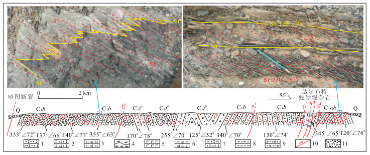
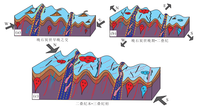
Detailed deformation analyses of the Zaire-Hala'alate Mountains show the following three different directional trends of regional structural features developed in the northwest margin of the Junggar basin: the south-north (S-N), northeast to southwest (NE-SW) and east-west (E-W) directions. The deformation sequences demonstrate that nearly S-N fold-thrust structures were developed during the early Late Carboniferous. During the late Late Carboniferous, nearly S-N tectonic orientation was transformed into the NE-SW direction by dragging. Meanwhile, the Darbut and Karamay ophiolitic mélanges were emplaced into the overlying Carboniferous strata by pulling-out under the control of dextral strike slip shearing or lateral wedge extrusion. Subsequently, NE-SW extensional faults, represented by the Darbut fault, were developed during the late Late Carboniferous to Permian, accompanied by extensive intrusion of intermediate to mafic dykes and granites. Between the end Permian and the Early Triassic, widespread E-W cleavages and thrust nappes in the Hala'alate Mountains were developed, and the Darbut sinistral strike slip fault was activated. From the Carboniferous to the Permian, the western Junggar underwent complicated evolutional processes including subduction, collision and intra-continental deformation, with multiphase tectonic overprints of compression and extension. The tectonic evolution history in the study area fully exhibits the regional geodynamic processes in the tectonic transformation deformation.
Detailed deformation analyses of the Zaire-Hala'alate Mountains show the following three different directional trends of regional structural features developed in the northwest margin of the Junggar basin: the south-north (S-N), northeast to southwest (NE-SW) and east-west (E-W) directions. The deformation sequences demonstrate that nearly S-N fold-thrust structures were developed during the early Late Carboniferous. During the late Late Carboniferous, nearly S-N tectonic orientation was transformed into the NE-SW direction by dragging. Meanwhile, the Darbut and Karamay ophiolitic mélanges were emplaced into the overlying Carboniferous strata by pulling-out under the control of dextral strike slip shearing or lateral wedge extrusion. Subsequently, NE-SW extensional faults, represented by the Darbut fault, were developed during the late Late Carboniferous to Permian, accompanied by extensive intrusion of intermediate to mafic dykes and granites. Between the end Permian and the Early Triassic, widespread E-W cleavages and thrust nappes in the Hala'alate Mountains were developed, and the Darbut sinistral strike slip fault was activated. From the Carboniferous to the Permian, the western Junggar underwent complicated evolutional processes including subduction, collision and intra-continental deformation, with multiphase tectonic overprints of compression and extension. The tectonic evolution history in the study area fully exhibits the regional geodynamic processes in the tectonic transformation deformation.


2015, 40(3): 521-534.
doi: 10.3799/dqkx.2015.041
Abstract:
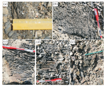
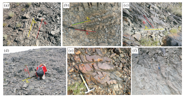
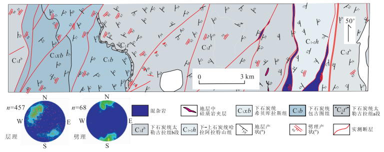
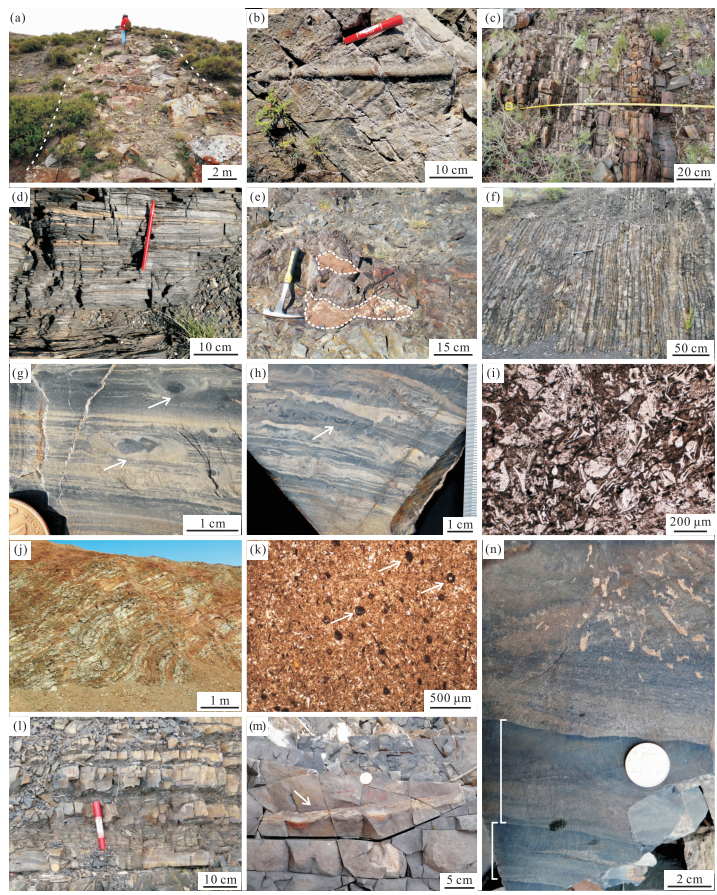
Cleavage is a type of penetrative planar rock feature produced under certain stress fields, commonly normal to the direction of maximum compression. Detailed investigation into the physical characteristics and sequences of different cleavages can facilitate the understanding of the regional deformational history, and further the tectonic evolution of a given area. Three categories of cleavages have been recognized through systematic observations of the penetrative cleavages developed in the Carboniferous turbidites in the Zaire Mountains of western Junggar: (1) relatively earlier cleavages associated with the tectonic emplacement of ophiolites; (2) later fault-related cleavages developed along major faults, such as the Darbut and Hatu faults; (3) cleavages with rather consistent east-west strike across region, and at various angles to bedding planes, which denote a widespread north-south regional compression. The earlier cleavages were formed during the Early-Late Late Carboniferous, when the older (Ordovician to Devonian) ophiolites got emplaced into the overlying younger (Carboniferous) strata due to the oblique convergence of different blocks and closing of ocean basins. The fault-related cleavages were related to extensive sinistral strike slip along NE-SW trending faults during the Permian-Triassic. The east-west cleavages didn t affect Mesozoic strata (the oldest of Late Triassic) in the region and crosscut granite porphyry veins dated as 305±15 Ma. In the consideration of the extensional tectonic background of the area from the Late Carboniferous to Perimain, the east-west cleavages probably lasted from the latest Permian to Middle Triassic, roughly concurrent with the fault-related cleavages of the second type, both of which signify an intracontinental north-south compression concurred with the southward movement of the Siberian plate.
Cleavage is a type of penetrative planar rock feature produced under certain stress fields, commonly normal to the direction of maximum compression. Detailed investigation into the physical characteristics and sequences of different cleavages can facilitate the understanding of the regional deformational history, and further the tectonic evolution of a given area. Three categories of cleavages have been recognized through systematic observations of the penetrative cleavages developed in the Carboniferous turbidites in the Zaire Mountains of western Junggar: (1) relatively earlier cleavages associated with the tectonic emplacement of ophiolites; (2) later fault-related cleavages developed along major faults, such as the Darbut and Hatu faults; (3) cleavages with rather consistent east-west strike across region, and at various angles to bedding planes, which denote a widespread north-south regional compression. The earlier cleavages were formed during the Early-Late Late Carboniferous, when the older (Ordovician to Devonian) ophiolites got emplaced into the overlying younger (Carboniferous) strata due to the oblique convergence of different blocks and closing of ocean basins. The fault-related cleavages were related to extensive sinistral strike slip along NE-SW trending faults during the Permian-Triassic. The east-west cleavages didn t affect Mesozoic strata (the oldest of Late Triassic) in the region and crosscut granite porphyry veins dated as 305±15 Ma. In the consideration of the extensional tectonic background of the area from the Late Carboniferous to Perimain, the east-west cleavages probably lasted from the latest Permian to Middle Triassic, roughly concurrent with the fault-related cleavages of the second type, both of which signify an intracontinental north-south compression concurred with the southward movement of the Siberian plate.


2015, 40(3): 535-547.
doi: 10.3799/dqkx.2015.042
Abstract:
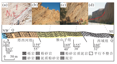
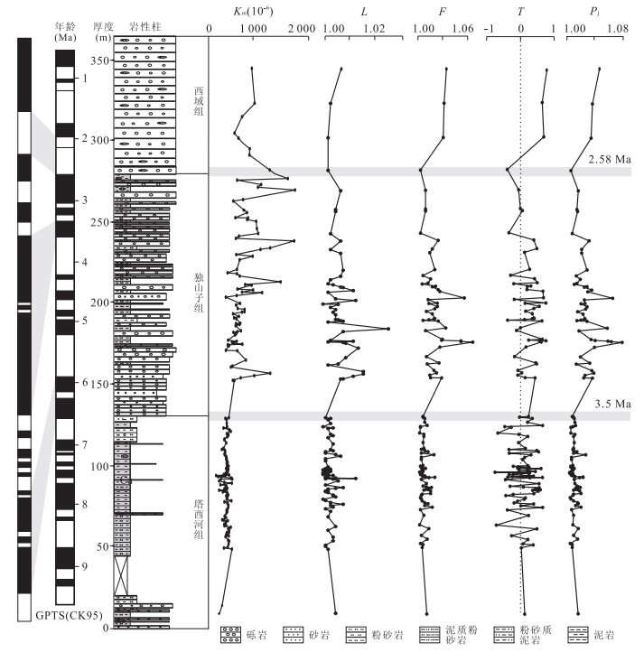
Through the results of detailed sedimentological and magnetic fabric study, on the Heshituoluogai basin, northwestern Junggar, we discussed the tectonic evolution since 7 Ma ago in the northwestern Junggar. The Baiyanghe section can be divided into Taxihe Formation, Dushanzi Formation and Xiyu Formation from bottom to up, corresponding to the lacustrine facies, fan delta facies and gravelly braided river facies. Paleocurrent and provenance analysis shows that the provenance of the section comes from the northern mountains nearby the basin. On the basis of the sedimentterological and magnetic fabric results, we divided the tectonic-sedimentary evolution of northwestern Junggar into three stages since 7 Ma ago: Ⅰ(6.80-3.50 Ma), lacustrine facies, lowest magnetic susceptibility and magnetic fabric parameters with small changes, indicating a stable tectonic environment, small topographic elevation difference or far provenance area; Ⅱ(3.50-2.58 Ma), fan delta facies, significant increase of the sedimentation rate, magnetic fabric parameters and magnetic susceptibility all suggest that the northwestern Junggar mountains underwent intense tectonic uplift; Ⅲ(< 2.58 Ma), gravelly braided river facies, magnetic fabric parameters and magnetic susceptibility increases further, which coused by tectonic uplift and climate change together. The tectonic uplift of the northwestern Junggar mountains occured at 3.50 Ma is almost synchronous with the uplift of the Tianshan Mountains and the Tibetan plateau occurred at 3.00-4.00 Ma, which is influenced by the far-filed effects of the India-Asia intracontinental subduction extrusion.
Through the results of detailed sedimentological and magnetic fabric study, on the Heshituoluogai basin, northwestern Junggar, we discussed the tectonic evolution since 7 Ma ago in the northwestern Junggar. The Baiyanghe section can be divided into Taxihe Formation, Dushanzi Formation and Xiyu Formation from bottom to up, corresponding to the lacustrine facies, fan delta facies and gravelly braided river facies. Paleocurrent and provenance analysis shows that the provenance of the section comes from the northern mountains nearby the basin. On the basis of the sedimentterological and magnetic fabric results, we divided the tectonic-sedimentary evolution of northwestern Junggar into three stages since 7 Ma ago: Ⅰ(6.80-3.50 Ma), lacustrine facies, lowest magnetic susceptibility and magnetic fabric parameters with small changes, indicating a stable tectonic environment, small topographic elevation difference or far provenance area; Ⅱ(3.50-2.58 Ma), fan delta facies, significant increase of the sedimentation rate, magnetic fabric parameters and magnetic susceptibility all suggest that the northwestern Junggar mountains underwent intense tectonic uplift; Ⅲ(< 2.58 Ma), gravelly braided river facies, magnetic fabric parameters and magnetic susceptibility increases further, which coused by tectonic uplift and climate change together. The tectonic uplift of the northwestern Junggar mountains occured at 3.50 Ma is almost synchronous with the uplift of the Tianshan Mountains and the Tibetan plateau occurred at 3.00-4.00 Ma, which is influenced by the far-filed effects of the India-Asia intracontinental subduction extrusion.


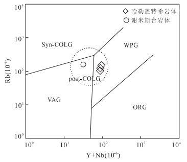
2015, 40(3): 548-562.
doi: 10.3799/dqkx.2015.043
Abstract:
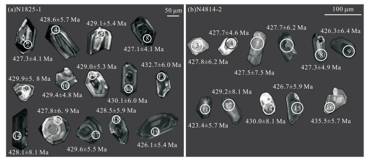
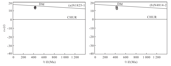
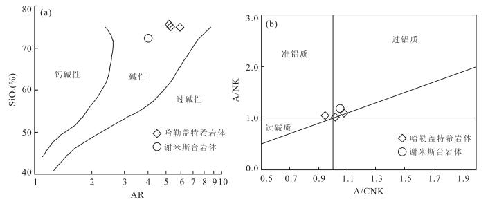
LA-ICP-MS U-Pb zircon age, geochemistry and Lu-Hf isotopic data for Xiemisitai and Halegaitexi granitic plutons in the western Junggar are presented in this paper, aiming to determine their forming ages, source regions and tectonic settings. LA-ICP-MS zircon yields 427.6±2.3 Ma for Xiemisitai alkali feldspar granites and 428.6±2.5 Ma for Halegaitexi alkali feldspar granites, respectively. Xiemisitai alkali feldspar granites are characterized as the Ⅰ-type granite, while Halegaitexi alkali feldspar granites have geochemical characteristics similar to the A-type granite. Zircon Lu-Hf isotopic compositions indicate that εHf(t)=12.4-14.5, two-stage model ages (tDM2) range from 497 to 603 Ma. The petrogenesis of Ⅰ-type and A-type granites were results of different evolutive phases of the same source magma in the compressible to extendable period of the post-collisional phase, which may be derived as follows. The southward subductional Irtysh-Zaysan Oceanic crust subductioned to the asthenospheric mantle which is the bottom of Boshchekul-Chingiz volcanic arc, resulted in the asthenospheric mafic magma underplating the lower crust. Then, the lower juvenile basaltic crust derived from the depleted mantle underwent different degrees of partial melting and fractional crystallization to a certain extent to generate the Ⅰ-type and A2-type granites.
LA-ICP-MS U-Pb zircon age, geochemistry and Lu-Hf isotopic data for Xiemisitai and Halegaitexi granitic plutons in the western Junggar are presented in this paper, aiming to determine their forming ages, source regions and tectonic settings. LA-ICP-MS zircon yields 427.6±2.3 Ma for Xiemisitai alkali feldspar granites and 428.6±2.5 Ma for Halegaitexi alkali feldspar granites, respectively. Xiemisitai alkali feldspar granites are characterized as the Ⅰ-type granite, while Halegaitexi alkali feldspar granites have geochemical characteristics similar to the A-type granite. Zircon Lu-Hf isotopic compositions indicate that εHf(t)=12.4-14.5, two-stage model ages (tDM2) range from 497 to 603 Ma. The petrogenesis of Ⅰ-type and A-type granites were results of different evolutive phases of the same source magma in the compressible to extendable period of the post-collisional phase, which may be derived as follows. The southward subductional Irtysh-Zaysan Oceanic crust subductioned to the asthenospheric mantle which is the bottom of Boshchekul-Chingiz volcanic arc, resulted in the asthenospheric mafic magma underplating the lower crust. Then, the lower juvenile basaltic crust derived from the depleted mantle underwent different degrees of partial melting and fractional crystallization to a certain extent to generate the Ⅰ-type and A2-type granites.


2015, 24(3): 548-562.
doi: 10.3799/dqkx.2015.043
Abstract:
LAICPMS UPb zircon age, geochemistry and LuHf isotopic data for Xiemisitai and Halegaitexi granitic plutons in the western Junggar are presented in this paper, aiming to determine their forming ages, source regions and tectonic settings. LAICPMS zircon yields 427.6±2.3Ma for Xiemisitai alkali feldspar granites and 428.6±2.5Ma for Halegaitexi alkali feldspar granites, respectively. Xiemisitai alkali feldspar granites are characterized as the Ⅰtype granite, while Halegaitexi alkali feldspar granites have geochemical characteristics similar to the Atype granite. Zircon LuHf isotopic compositions indicate that εHf(t)=12.4-14.5, twostage model ages (tDM2) range from 497 to 603Ma. The petrogenesis of Ⅰtype and Atype granites were results of different evolutive phases of the same source magma in the compressible to extendable period of the postcollisional phase, which may be derived as follows. The southward subductional IrtyshZaysan Oceanic crust subductioned to the asthenospheric mantle which is the bottom of BoshchekulChingiz volcanic arc, resulted in the asthenospheric mafic magma underplating the lower crust. Then, the lower juvenile basaltic crust derived from the depleted mantle underwent different degrees of partial melting and fractional crystallization to a certain extent to generate the Ⅰtype and A2type granites.
LAICPMS UPb zircon age, geochemistry and LuHf isotopic data for Xiemisitai and Halegaitexi granitic plutons in the western Junggar are presented in this paper, aiming to determine their forming ages, source regions and tectonic settings. LAICPMS zircon yields 427.6±2.3Ma for Xiemisitai alkali feldspar granites and 428.6±2.5Ma for Halegaitexi alkali feldspar granites, respectively. Xiemisitai alkali feldspar granites are characterized as the Ⅰtype granite, while Halegaitexi alkali feldspar granites have geochemical characteristics similar to the Atype granite. Zircon LuHf isotopic compositions indicate that εHf(t)=12.4-14.5, twostage model ages (tDM2) range from 497 to 603Ma. The petrogenesis of Ⅰtype and Atype granites were results of different evolutive phases of the same source magma in the compressible to extendable period of the postcollisional phase, which may be derived as follows. The southward subductional IrtyshZaysan Oceanic crust subductioned to the asthenospheric mantle which is the bottom of BoshchekulChingiz volcanic arc, resulted in the asthenospheric mafic magma underplating the lower crust. Then, the lower juvenile basaltic crust derived from the depleted mantle underwent different degrees of partial melting and fractional crystallization to a certain extent to generate the Ⅰtype and A2type granites.
2015, 40(3): 563-572.
doi: 10.3799/dqkx.2015.044
Abstract:
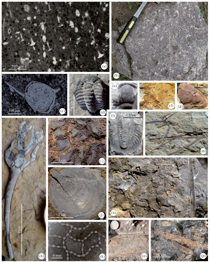
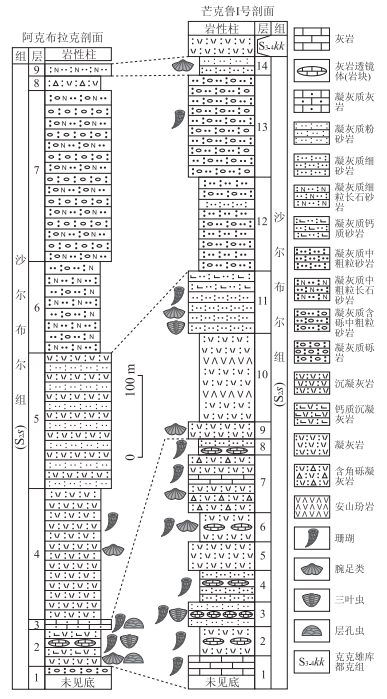
Abundant Wenlock animal fossils are found in the succession of the volcanoclastic rocks intercalated with limestones which were considered as the Late Devonian Ta'erbahatai Formation, including corals Halysites hoboksarensis, H. sp., Mesofavosites sp., brachiopods Atrypa sp., Eospirifer radiates, trilobites Encrinuroides sp., Encrinurus sp.1, E. sp.2, Cheirurus sp., Sthenarocalymene sp., Machaeridia Lepidocoleus sp., stromatoporoids and so on. Based on lithological association and stratal correlation, the succession is re-assigned to the Wenlock Shaerbuer Formation, where abundant facies indicators were discovered. Main facies indicators include reefoid corals and stromatoporoids, graded bedding, convolute bedding, flame structure and storm deposits. It is concluded that the Wenlock Shaerbuer Formation was formed in the open platform environment with volcanic activities in tropical and subtropical zones.
Abundant Wenlock animal fossils are found in the succession of the volcanoclastic rocks intercalated with limestones which were considered as the Late Devonian Ta'erbahatai Formation, including corals Halysites hoboksarensis, H. sp., Mesofavosites sp., brachiopods Atrypa sp., Eospirifer radiates, trilobites Encrinuroides sp., Encrinurus sp.1, E. sp.2, Cheirurus sp., Sthenarocalymene sp., Machaeridia Lepidocoleus sp., stromatoporoids and so on. Based on lithological association and stratal correlation, the succession is re-assigned to the Wenlock Shaerbuer Formation, where abundant facies indicators were discovered. Main facies indicators include reefoid corals and stromatoporoids, graded bedding, convolute bedding, flame structure and storm deposits. It is concluded that the Wenlock Shaerbuer Formation was formed in the open platform environment with volcanic activities in tropical and subtropical zones.


2015, 40(3): 573-587.
doi: 10.3799/dqkx.2015.045
Abstract:
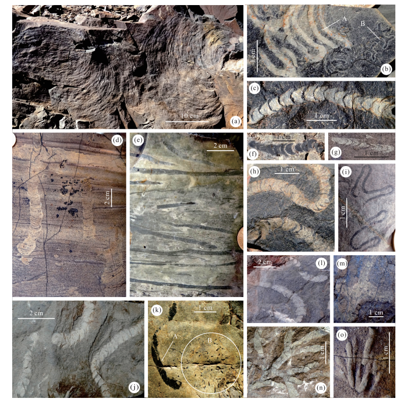
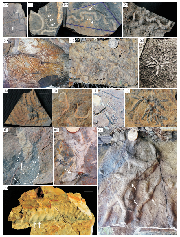
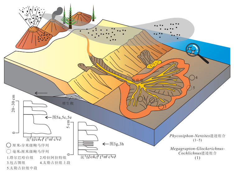
The flysch trace fossils of western Junggar, Xinjiang, NW China are mainly distributed in the Upper Devonian-Lower Carboniferous Ta'erbahatai Formation and Baogutu, Tailegula and Hala'alate formations of the Carboniferous. Characteristic trace fossils include Phycosiphon, Nereites, Megagrapton, Glockerichnus, Cochlichnus, Lophoctenium, Gordia, Chondrites, Zoophycos, Scolicia, Thalassinoides, forming two characteristic trace fossil assemblages of the Nereites ichnofacies: the Phycosiphon-Nereites and Megagrapton-Glockerichnus-Cochlichnus ichnoassemblages. The Baogutu and Tailegula formations represent the medial-distal submarine fan fringe-basin plain environments, while the Hala'alate and Ta'erbahatai formations are chiefly medial-distal submarine fan lobe deposits. The distribution of flysch trace fossils in western Junggar is closely linked to the thickness of the Bouma sequences. In millimetre to centimetre Bouma sequences, there are only scarce and blur traces of Phycosiphon or Nereites, while in centimetre to decimetre Bouma sequences, Phycosiphon and Nereites of various diametres and transitional morphologies occur, which might be produced by conspecific trace makers in an ontogenetic series. The thickness of a single Bouma sequence in submarine fan related environments determines if there is enough time for a mature benthic fauna to develop (with a series of young and old individuals).
The flysch trace fossils of western Junggar, Xinjiang, NW China are mainly distributed in the Upper Devonian-Lower Carboniferous Ta'erbahatai Formation and Baogutu, Tailegula and Hala'alate formations of the Carboniferous. Characteristic trace fossils include Phycosiphon, Nereites, Megagrapton, Glockerichnus, Cochlichnus, Lophoctenium, Gordia, Chondrites, Zoophycos, Scolicia, Thalassinoides, forming two characteristic trace fossil assemblages of the Nereites ichnofacies: the Phycosiphon-Nereites and Megagrapton-Glockerichnus-Cochlichnus ichnoassemblages. The Baogutu and Tailegula formations represent the medial-distal submarine fan fringe-basin plain environments, while the Hala'alate and Ta'erbahatai formations are chiefly medial-distal submarine fan lobe deposits. The distribution of flysch trace fossils in western Junggar is closely linked to the thickness of the Bouma sequences. In millimetre to centimetre Bouma sequences, there are only scarce and blur traces of Phycosiphon or Nereites, while in centimetre to decimetre Bouma sequences, Phycosiphon and Nereites of various diametres and transitional morphologies occur, which might be produced by conspecific trace makers in an ontogenetic series. The thickness of a single Bouma sequence in submarine fan related environments determines if there is enough time for a mature benthic fauna to develop (with a series of young and old individuals).


2015, 40(3): 588-596.
doi: 10.3799/dqkx.2015.046
Abstract:
The Devonian Famennian conodont and chondrichthy have been found from the newly established Taketai Formation which previously was assigned to the Early Carboniferous Hebukehe Formation in Halayemen region, western Junggar. Conodont fossils include 3 genera, 6 species and 1 indeterminate species: Icriodus alternatus alternatus, Icriodus cornutus, Icriodus expansus, Icriodus sp.1, Icriodus sp.2, Polygnathus krestovnikovi, Polygnathus procerus, Polygnathus makhlinae, Polygnathus sp.1, Polygnathus sp.2, Polygnathus sp.3, Ancyrognathus sp.. Chondrichthyes include 2 genera: Protacrodus sp. and Phoebodus sp.. It indicates that Taketai Formation belongs to early Famennian of Late Devonian.
The Devonian Famennian conodont and chondrichthy have been found from the newly established Taketai Formation which previously was assigned to the Early Carboniferous Hebukehe Formation in Halayemen region, western Junggar. Conodont fossils include 3 genera, 6 species and 1 indeterminate species: Icriodus alternatus alternatus, Icriodus cornutus, Icriodus expansus, Icriodus sp.1, Icriodus sp.2, Polygnathus krestovnikovi, Polygnathus procerus, Polygnathus makhlinae, Polygnathus sp.1, Polygnathus sp.2, Polygnathus sp.3, Ancyrognathus sp.. Chondrichthyes include 2 genera: Protacrodus sp. and Phoebodus sp.. It indicates that Taketai Formation belongs to early Famennian of Late Devonian.


2015, 24(3): 588-596.
doi: 10.3799/dqkx.2015.046
Abstract:
The Devonian Famennian conodont and chondrichthy have been found from the newly established Taketai Formation which previously was assigned to the Early Carboniferous Hebukehe Formation in Halayemen region, western Junggar. Conodont fossils include 3 genera, 6 species and 1 indeterminate species: Icriodus alternatus alternatus, Icriodus cornutus, Icriodus expansus, Icriodus sp.1, Icriodus sp.2, Polygnathus krestovnikovi, Polygnathus procerus, Polygnathus makhlinae, Polygnathus sp.1, Polygnathus sp.2, Polygnathus sp.3, Ancyrognathus sp.. Chondrichthyes include 2 genera: Protacrodus sp. and Phoebodus sp.. It indicates that Taketai Formation belongs to early Famennian of Late Devonian.
The Devonian Famennian conodont and chondrichthy have been found from the newly established Taketai Formation which previously was assigned to the Early Carboniferous Hebukehe Formation in Halayemen region, western Junggar. Conodont fossils include 3 genera, 6 species and 1 indeterminate species: Icriodus alternatus alternatus, Icriodus cornutus, Icriodus expansus, Icriodus sp.1, Icriodus sp.2, Polygnathus krestovnikovi, Polygnathus procerus, Polygnathus makhlinae, Polygnathus sp.1, Polygnathus sp.2, Polygnathus sp.3, Ancyrognathus sp.. Chondrichthyes include 2 genera: Protacrodus sp. and Phoebodus sp.. It indicates that Taketai Formation belongs to early Famennian of Late Devonian.
