2015 Vol. 40, No. 6
Display Method:
2015, 40(6): 941-952.
doi: 10.3799/dqkx.2015.079
 PDF 3783KB
Abstract:
Late Carboniferous-Early Permian post-collision plutons are extensively distributed throughout the West Junggar, Xinjiang, China, of which the Akebasitao pluton is the most distinguished one. However, investigations on the three-dimensional configuration and emplacement mechanism of the pluton remain relatively insufficient. A multidisciplinary approach, including field structure and audio magnetotelluric sounding, has been adopted for study on the Akebasitao pluton. The geological features and the audio magnetotelluric sounding exploration suggest that the pluton, with an asymmetrical mushroom-shape and slightly oblique movement of magma from NW to SE, formed in the post-orogenic extensional environment.What is more, the three-dimensional configuartion of the pluton reveals that the West Junggar was of post-orogenic extensional environment in the Late Carboniferous to Early Permian. This study has important implication for three-dimensional shape of those post-collision plutons that are widely developped in West Junggar.
Late Carboniferous-Early Permian post-collision plutons are extensively distributed throughout the West Junggar, Xinjiang, China, of which the Akebasitao pluton is the most distinguished one. However, investigations on the three-dimensional configuration and emplacement mechanism of the pluton remain relatively insufficient. A multidisciplinary approach, including field structure and audio magnetotelluric sounding, has been adopted for study on the Akebasitao pluton. The geological features and the audio magnetotelluric sounding exploration suggest that the pluton, with an asymmetrical mushroom-shape and slightly oblique movement of magma from NW to SE, formed in the post-orogenic extensional environment.What is more, the three-dimensional configuartion of the pluton reveals that the West Junggar was of post-orogenic extensional environment in the Late Carboniferous to Early Permian. This study has important implication for three-dimensional shape of those post-collision plutons that are widely developped in West Junggar.


2015, 40(6): 953-964, 1060.
doi: 10.3799/dqkx.2015.080
Abstract:
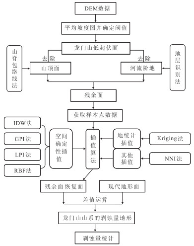
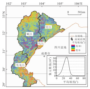
Longmen Shan located at the eastern margin of Tibetan Plateau represents the steepest gradient of the Tibetan Plateau edges. To assess the large-scale denudation volume in Longmen Shan, Late Cenozoic, surface denudation is quantitatively calculated along several large drainage basins such as Qingyijiang, Minjiang, Tuojiang, and Fujiang rivers by using digital elevation models (DEM) data, and residual surface method with paleo-residual surface DEM minus modern surface topography in this study. It is found that the Late Cenozoic denudation volume of upper reaches in Longmen Shan drainage basin is between 80 500 and 92 800 km3. Minjiang River has the largest contribution ratio to denudation in Longmen Shan (33.9%-37.1%), followed by Fujiang (33.6%-38.4%) and Qingyijiang Rivers (24.1%-31.9%), and Tuojiang River has minimum contribution (0.4%-0.6%). A rapid erosional removal from the Longmen Shan by repeated great seismic events like the Wenchuan earthquake on May 12th, 2008, may be a main reason of the surface erosion in Late Cenozoic Longmen Shan along the eastern margin of Tibetan Plateau.
Longmen Shan located at the eastern margin of Tibetan Plateau represents the steepest gradient of the Tibetan Plateau edges. To assess the large-scale denudation volume in Longmen Shan, Late Cenozoic, surface denudation is quantitatively calculated along several large drainage basins such as Qingyijiang, Minjiang, Tuojiang, and Fujiang rivers by using digital elevation models (DEM) data, and residual surface method with paleo-residual surface DEM minus modern surface topography in this study. It is found that the Late Cenozoic denudation volume of upper reaches in Longmen Shan drainage basin is between 80 500 and 92 800 km3. Minjiang River has the largest contribution ratio to denudation in Longmen Shan (33.9%-37.1%), followed by Fujiang (33.6%-38.4%) and Qingyijiang Rivers (24.1%-31.9%), and Tuojiang River has minimum contribution (0.4%-0.6%). A rapid erosional removal from the Longmen Shan by repeated great seismic events like the Wenchuan earthquake on May 12th, 2008, may be a main reason of the surface erosion in Late Cenozoic Longmen Shan along the eastern margin of Tibetan Plateau.


2015, 40(6): 965-981.
doi: 10.3799/dqkx.2015.081
Abstract:
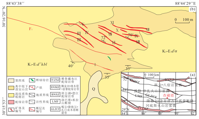
The Gerizhuotuo complex intrusion, a typical 'stitching pluton' with its long axis cutting regional structural lines, is significant in tectonic geochronology for providing an upper-age for the timing of plate collision. The zircon U-Pb dating results indicate that the pluton was formed in 227-224 Ma. Geochemically, porphyritic granite falls into the high-K calc-alkaline series, with high Sr(479-573 μg/g) and low Yb(1.03-1.20 μg/g) and Mg#(48.7-51.8), being of the characteristics of adakitic rocks. The in situ zircon εHf(t) value varies from -2.40 to 2.98, which suggests that the primary magma was derived from partial melting of lower crustal materials. Diorite also shows high-K calc-alkaline affinitie, with a Ti/Yb ratio ranging from 1 930 to 2 178, Nb/Ta ratio ranging from 15.9 to 17.4. It is suggested that a mixture, between basaltic magma derived from partial melting of metasomatized mantle and acidic magma derived from crustal material, produced the dioritic magma. It is concluded that the pluton was formed in a post-collisional tensional environment.
The Gerizhuotuo complex intrusion, a typical 'stitching pluton' with its long axis cutting regional structural lines, is significant in tectonic geochronology for providing an upper-age for the timing of plate collision. The zircon U-Pb dating results indicate that the pluton was formed in 227-224 Ma. Geochemically, porphyritic granite falls into the high-K calc-alkaline series, with high Sr(479-573 μg/g) and low Yb(1.03-1.20 μg/g) and Mg#(48.7-51.8), being of the characteristics of adakitic rocks. The in situ zircon εHf(t) value varies from -2.40 to 2.98, which suggests that the primary magma was derived from partial melting of lower crustal materials. Diorite also shows high-K calc-alkaline affinitie, with a Ti/Yb ratio ranging from 1 930 to 2 178, Nb/Ta ratio ranging from 15.9 to 17.4. It is suggested that a mixture, between basaltic magma derived from partial melting of metasomatized mantle and acidic magma derived from crustal material, produced the dioritic magma. It is concluded that the pluton was formed in a post-collisional tensional environment.


2015, 40(6): 982-994.
doi: 10.3799/dqkx.2015.082
Abstract:
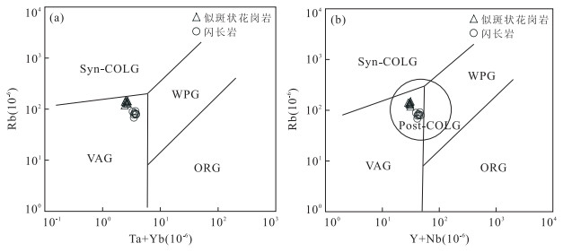
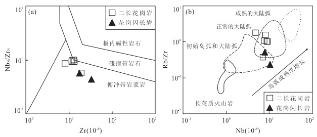
The tectonic evolution of southern Khanka block is very complex, and there is not enough of the precise chronological evidence and systematic geochemical studies. Zircon U-Pb dating results show that the granites from southern Xingkai block were intruded at the end of Late Triassic (202-205 Ma) in a transition stage of paleo-Asian Ocean and paleo-Pacific tectonic system. It is found that the monzonitic granites and granodiorites are all characterized with enriched silicon (SiO2=69.61%-77.27%), weakly supersaturated aluminum (Al2O3=12.70%-15.28%) and relatively enriched potassium (AKI=0.64-0.88), which indicates that the granites are fractionated Ⅰ-type granites, taking into account of the presence of amphibole and low zircon saturation temperature (TZr=679-787 ℃). 176Hf/177Hf ratios are high (0.282 773-0.282 913); εHf(t) is positive (4.39-9.32), and two-stage Hf model ages are young (0.65-0.96 Ga), which shows that its source material is from the depleted mantle of new-born young crust of Neoproterozoic. It is concluded that the granite was formed in the context of the initial western Pacific subduction into active continental margin based on the age of the rock formation, and other rock features.
The tectonic evolution of southern Khanka block is very complex, and there is not enough of the precise chronological evidence and systematic geochemical studies. Zircon U-Pb dating results show that the granites from southern Xingkai block were intruded at the end of Late Triassic (202-205 Ma) in a transition stage of paleo-Asian Ocean and paleo-Pacific tectonic system. It is found that the monzonitic granites and granodiorites are all characterized with enriched silicon (SiO2=69.61%-77.27%), weakly supersaturated aluminum (Al2O3=12.70%-15.28%) and relatively enriched potassium (AKI=0.64-0.88), which indicates that the granites are fractionated Ⅰ-type granites, taking into account of the presence of amphibole and low zircon saturation temperature (TZr=679-787 ℃). 176Hf/177Hf ratios are high (0.282 773-0.282 913); εHf(t) is positive (4.39-9.32), and two-stage Hf model ages are young (0.65-0.96 Ga), which shows that its source material is from the depleted mantle of new-born young crust of Neoproterozoic. It is concluded that the granite was formed in the context of the initial western Pacific subduction into active continental margin based on the age of the rock formation, and other rock features.


2015, 40(6): 995-1005.
doi: 10.3799/dqkx.2015.083
Abstract:
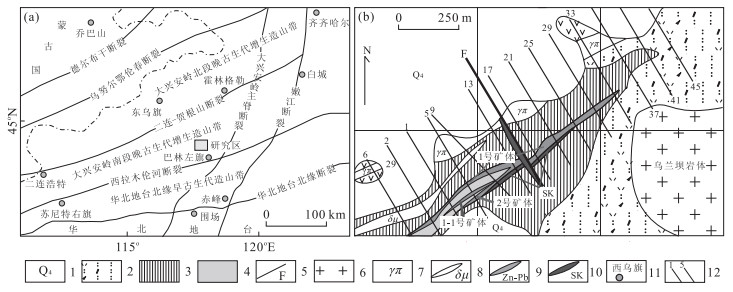
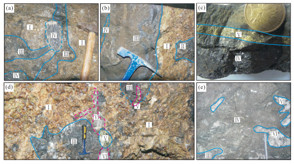
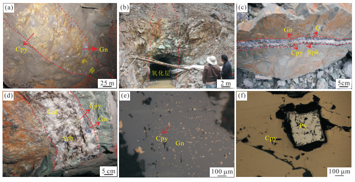
Hongling lead-zinc deposit is one of the representative large deposits in southeastern Inner Mongolia. Presently, there's very little research on geochemical characteristics and evolution of ore-form fluids, and ore genesis. The fluid inclusions are systemly researched in this paper, The results show that there are three types of primary fluid inclusions in garnet of garnet-skarn stage (Ⅰ) including halite-bearing three-phase, aqueous two-phase as well as vapor-rich two-phase; there are two types of primary fluid inclusions in quartz of stage (Ⅱ) including aqueous two-phase as well as vapor-rich two-phase. It is found in our microthermometric study that the ore-forming fluid is of high temperature, high salinity and immiscible NaCl-H2O type solutions and the boiling process plays important role in the precipitation of Pb, Zn, and Cu. Quartz of mineralization stage Ⅲ to Ⅳ of quartz-sulfide epochs contains only aqueous two-phase of fluid inclusions. The homogenization temperature of this type of fluid inclusions is obviously lower than that of skarn epoch, while the salinity does not obviously change. The homogenization temperatures of fluid inclusions show a rising trend with salinities displaying a dropping trend of stage Ⅳ, and it may be caused by adding of high temperature, low salinity type fluid. The dropping of homogenization temperatures and salinities of ore-forming fluids from mineralization stages Ⅴ to Ⅵ suggests that meteoric water continuously joining into the ore-forming fluid. Overall, the ore-forming fluids of quartz-sulfide epoch is of medium-low temperature and low salinity NaCl-H2O type solutions. C, H, O isotope study of fluid inclusions shows that the ore-forming fluids of skarn epoch mainly came from magmatic water and that of quartz-sulfide epoch came from mixed magmatic water and meteoric water, whereas at the latest stage of mineralization, the ore-forming fluids mainly came from meteoric water. The study of S, Pb isotopes implies that the ore-forming materials posed a deep source feature.
Hongling lead-zinc deposit is one of the representative large deposits in southeastern Inner Mongolia. Presently, there's very little research on geochemical characteristics and evolution of ore-form fluids, and ore genesis. The fluid inclusions are systemly researched in this paper, The results show that there are three types of primary fluid inclusions in garnet of garnet-skarn stage (Ⅰ) including halite-bearing three-phase, aqueous two-phase as well as vapor-rich two-phase; there are two types of primary fluid inclusions in quartz of stage (Ⅱ) including aqueous two-phase as well as vapor-rich two-phase. It is found in our microthermometric study that the ore-forming fluid is of high temperature, high salinity and immiscible NaCl-H2O type solutions and the boiling process plays important role in the precipitation of Pb, Zn, and Cu. Quartz of mineralization stage Ⅲ to Ⅳ of quartz-sulfide epochs contains only aqueous two-phase of fluid inclusions. The homogenization temperature of this type of fluid inclusions is obviously lower than that of skarn epoch, while the salinity does not obviously change. The homogenization temperatures of fluid inclusions show a rising trend with salinities displaying a dropping trend of stage Ⅳ, and it may be caused by adding of high temperature, low salinity type fluid. The dropping of homogenization temperatures and salinities of ore-forming fluids from mineralization stages Ⅴ to Ⅵ suggests that meteoric water continuously joining into the ore-forming fluid. Overall, the ore-forming fluids of quartz-sulfide epoch is of medium-low temperature and low salinity NaCl-H2O type solutions. C, H, O isotope study of fluid inclusions shows that the ore-forming fluids of skarn epoch mainly came from magmatic water and that of quartz-sulfide epoch came from mixed magmatic water and meteoric water, whereas at the latest stage of mineralization, the ore-forming fluids mainly came from meteoric water. The study of S, Pb isotopes implies that the ore-forming materials posed a deep source feature.


2015, 40(6): 1006-1016.
doi: 10.3799/dqkx.2015.084
Abstract:
Chazangcuo Cu-Pb-Zn deposit, hosted by the Linzizong Group volcanic rocks in the west of Gangdese metallogenic belt, is a copper polymetallic deposit discovered in recent years. So far, the genesis of the deposit is still lack of clear understanding. The results of C, H, O, S, Pb isotopic analysis show that the δ13CV-PDB values range from -5.60‰ to -2.40‰, δDV-SMOW values range from -111.00‰ to -68.00‰, and δ18OV-SMOW values range from -8.65‰ to 0.27‰, indicating that the ore-forming fluid mainly derived from the magma hydrothermal in the early time, however, with the mineralization continuing, the proportion of atmospheric precipitation gradually turned larger. δ34SCDT values range from 0.50‰ to 2.50‰ and possess the distribution characteristics of tower, indicating that the sulfur isotope derived from the single magma source. Lead isotope ratios are relatively stable and have large μ values (more than 9.58), possessing the characteristics of the upper crust lead. The lead isotope characteristics are similar to the ore sulfides from the deposits in the north subzone of Gangdese metallogenic belt, but obviously different from the lead isotope characteristics of volcanic rocks of Dianzhong Formation. Therefore, the authors infer that the source of ore-forming materials mainly came from the magmatic source of the upper crust. Combining with the geological characteristics of Chazangcuo deposit, and contrasting the typical magmatic hydrothermal vein-type deposit at home and abroad, the authors think that it belongs to the typical magmatic hydrothermal vein-type deposit.
Chazangcuo Cu-Pb-Zn deposit, hosted by the Linzizong Group volcanic rocks in the west of Gangdese metallogenic belt, is a copper polymetallic deposit discovered in recent years. So far, the genesis of the deposit is still lack of clear understanding. The results of C, H, O, S, Pb isotopic analysis show that the δ13CV-PDB values range from -5.60‰ to -2.40‰, δDV-SMOW values range from -111.00‰ to -68.00‰, and δ18OV-SMOW values range from -8.65‰ to 0.27‰, indicating that the ore-forming fluid mainly derived from the magma hydrothermal in the early time, however, with the mineralization continuing, the proportion of atmospheric precipitation gradually turned larger. δ34SCDT values range from 0.50‰ to 2.50‰ and possess the distribution characteristics of tower, indicating that the sulfur isotope derived from the single magma source. Lead isotope ratios are relatively stable and have large μ values (more than 9.58), possessing the characteristics of the upper crust lead. The lead isotope characteristics are similar to the ore sulfides from the deposits in the north subzone of Gangdese metallogenic belt, but obviously different from the lead isotope characteristics of volcanic rocks of Dianzhong Formation. Therefore, the authors infer that the source of ore-forming materials mainly came from the magmatic source of the upper crust. Combining with the geological characteristics of Chazangcuo deposit, and contrasting the typical magmatic hydrothermal vein-type deposit at home and abroad, the authors think that it belongs to the typical magmatic hydrothermal vein-type deposit.


2015, 40(6): 1017-1033.
doi: 10.3799/dqkx.2015.085
Abstract:
Kuluketage block is one of the best areas for Precambrian geology studies in Xinjiang, however, the regional metallogeny of the research area is still too poon. In this paper, all the published literatures are summarized. Then, the geology of main ore deposits and the classified metallogenic series in this block are systematically described. The following seven tectonothermal periods are distinguished: Archean crust nucleus growing stage (3.3-3.0 Ga), Neoarchean-Paleoproterozoic crust growth and transformation stage (2.6-2.3 Ga), middle-late Paleoproterozoic crust transformation stage (2.1-1.8 Ga), Late Mesoproterozoic to Early Neoproterozoic orogeny stage (1.1-0.86 Ga), Middle Neoproterozoic orogenic extensional stage (830-800 Ma), middle-late Neoproterozoic intracontinental breakup stage (770-630 Ma) and Early Paleozoic land building stage. Mineralization mainly occurred at Paleoproterozoic, Neoproterozoic and Early Paleozoic. According to the ore-forming tectonic settings, ore-bearing rock formations and ore deposit genesis, six typical metallogenic series are identified in our study, including Fe-P-Cu-Au metallogenic series formed at Paleoproterozoic crust growth and transformation stage, Cu-Au metallogenic series formed at Early Neoproterozoic orogeny stage, Cu-Mo-Au-Fe-P-REE metallogenic series formed at Neoproterozoic post-collision stage, Cu-Ni metallogenic series formed at Neoproterozic rifting stage, Ag-V-Mo-Au-U-P metallogenic series formed at Early Paleozoic sedimentary basin and Cu-Au metallogenic series formed at Early Paleozoic arc subduction stage.
Kuluketage block is one of the best areas for Precambrian geology studies in Xinjiang, however, the regional metallogeny of the research area is still too poon. In this paper, all the published literatures are summarized. Then, the geology of main ore deposits and the classified metallogenic series in this block are systematically described. The following seven tectonothermal periods are distinguished: Archean crust nucleus growing stage (3.3-3.0 Ga), Neoarchean-Paleoproterozoic crust growth and transformation stage (2.6-2.3 Ga), middle-late Paleoproterozoic crust transformation stage (2.1-1.8 Ga), Late Mesoproterozoic to Early Neoproterozoic orogeny stage (1.1-0.86 Ga), Middle Neoproterozoic orogenic extensional stage (830-800 Ma), middle-late Neoproterozoic intracontinental breakup stage (770-630 Ma) and Early Paleozoic land building stage. Mineralization mainly occurred at Paleoproterozoic, Neoproterozoic and Early Paleozoic. According to the ore-forming tectonic settings, ore-bearing rock formations and ore deposit genesis, six typical metallogenic series are identified in our study, including Fe-P-Cu-Au metallogenic series formed at Paleoproterozoic crust growth and transformation stage, Cu-Au metallogenic series formed at Early Neoproterozoic orogeny stage, Cu-Mo-Au-Fe-P-REE metallogenic series formed at Neoproterozoic post-collision stage, Cu-Ni metallogenic series formed at Neoproterozic rifting stage, Ag-V-Mo-Au-U-P metallogenic series formed at Early Paleozoic sedimentary basin and Cu-Au metallogenic series formed at Early Paleozoic arc subduction stage.


2015, 40(6): 1034-1051.
doi: 10.3799/dqkx.2015.086
Abstract:
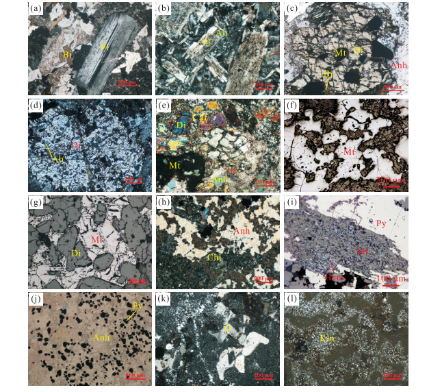
The inheritance of elements migration can't be definitely revealed by traditional methods from Nihe iron ore deposit, which has a multi-stage hydrothermal superimposed alteration process. The quantitative features of the main and trace element migration in the process of hydrothermal alteration is presented in the paper by exploring its prospecting significance by adopting the early alteration rock for original rock and then fitting the best concentration equation between slightly late alteration rock with immobile elements by isocon diagram method. It is found that the cations precipitation sequence is roughly from Na to Ca, Mg, Fe, P to Ca, Fe and to Al, Si in Nihe iron deposit. As elements into and out of the system are continuous complementary for both early to late alterations, the alteration and mineralization are considered as a continuous process. The extensive albitization is a sign of Na qualitative precipitation, marking the beginning of iron ore mineralization. Anhydrite-diopside mineralization is the result of Ca, Mg and Fe qualitative precipitation which is the ore-closing and ore-hosting alteration. Secondary quartzite and kaolinization is the Al, Si qualitative precipitation migrated from early alteration, which is the long-distance indicative alteration of magnetite.
The inheritance of elements migration can't be definitely revealed by traditional methods from Nihe iron ore deposit, which has a multi-stage hydrothermal superimposed alteration process. The quantitative features of the main and trace element migration in the process of hydrothermal alteration is presented in the paper by exploring its prospecting significance by adopting the early alteration rock for original rock and then fitting the best concentration equation between slightly late alteration rock with immobile elements by isocon diagram method. It is found that the cations precipitation sequence is roughly from Na to Ca, Mg, Fe, P to Ca, Fe and to Al, Si in Nihe iron deposit. As elements into and out of the system are continuous complementary for both early to late alterations, the alteration and mineralization are considered as a continuous process. The extensive albitization is a sign of Na qualitative precipitation, marking the beginning of iron ore mineralization. Anhydrite-diopside mineralization is the result of Ca, Mg and Fe qualitative precipitation which is the ore-closing and ore-hosting alteration. Secondary quartzite and kaolinization is the Al, Si qualitative precipitation migrated from early alteration, which is the long-distance indicative alteration of magnetite.


2015, 40(6): 1052-1060.
doi: 10.3799/dqkx.2015.087
Abstract:
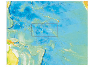
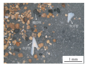
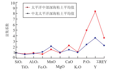
REE resources from deep-sea sediments is a kind of newly discovered and latent REE resources deposited on the ocean floor. Mineral component, major element and rare earth element analysis of 90 pelagic clay samples by piston core from the central Pacific have been conducted and compared with the geochemical chemistry of pelagic sediments from the central North Pacifc and Minami-Torishima area in the western North Pacific in this study. The results show that the pelagic clay from the central Pacific is rich in phillipsite, P, and REY, and significant fish teeth debris are contained in detrital component of pelagic clay; CaO and P2O5, CaO, P2O5 and ∑REY are positively correlated, and characterized by clear Ce negative anomaly and certain HREE enrichment and Y positive anomaly in REE distribution. The REY enrichment of pelagic clay from the central Pacific is mainly caused by excess phosphate component which may have resulted from the fish teeth debris mixed in the pelagic clay. The REY enrichment mechanism of REY-rich pelagic sediments in the North Pacific with no hydrothermal effect shows uniformity and universality, which can be attributed to the admixture of high-REY phosphate in the pelagic clay.
REE resources from deep-sea sediments is a kind of newly discovered and latent REE resources deposited on the ocean floor. Mineral component, major element and rare earth element analysis of 90 pelagic clay samples by piston core from the central Pacific have been conducted and compared with the geochemical chemistry of pelagic sediments from the central North Pacifc and Minami-Torishima area in the western North Pacific in this study. The results show that the pelagic clay from the central Pacific is rich in phillipsite, P, and REY, and significant fish teeth debris are contained in detrital component of pelagic clay; CaO and P2O5, CaO, P2O5 and ∑REY are positively correlated, and characterized by clear Ce negative anomaly and certain HREE enrichment and Y positive anomaly in REE distribution. The REY enrichment of pelagic clay from the central Pacific is mainly caused by excess phosphate component which may have resulted from the fish teeth debris mixed in the pelagic clay. The REY enrichment mechanism of REY-rich pelagic sediments in the North Pacific with no hydrothermal effect shows uniformity and universality, which can be attributed to the admixture of high-REY phosphate in the pelagic clay.


2015, 40(6): 1061-1071.
doi: 10.3799/dqkx.2015.088
Abstract:
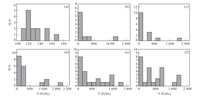
In order to clarify the controlling effects of tectonic activities on the sediment supply and sedimentary filling, the sediment supply of the Huizhou depression is quantitatively studied by analyzing the changes in the shape and chronology of the detrital zircons of eight samples from different formations, with LA-ICPMS zircon U-Pb dating as the main measuring method. The southern provenance areas, Dongsha Massif and the internal uplifts of the basin, are predominantly composed of Mesozoic igneous rocks, while northern provenance areas, South China folded belt, are characterized by complicated lithology and geochronology. The results show that the content of Mesozoic zircon grains decreases while that of Precambrian-Paleozoic zircon grains increases and then prevails gradually from the Lower Wenchang Formation to the Upper Wenchang Formation and to the Enping Formation, confirming that the area provenance system switched a south provenance in the basin to a north provenance out of the basin gradually. The evolution of Huizhou depression in Paleogene can be divided into three rifted stages: periods ⅠA, ⅠB and Ⅱ. During period ⅠA (Lower Wenchang Formation), the southern faults of depression suffered strong activities. All zircon grains are derived from Mesozoic, indicating sediments derived from the southern provenance areas. The related sedimentary facies are characterized by fan delta and middle-deep lake under the conditions of southern steep slope of Huizhou depression. During period IB, corresponding to Upper Wenchang Formation, the tectonic activities are characterized by high subsidence rates in the northern fault zones. The content of Mesozoic grains is 68%, whereas the content of Precambrian-Paleozoic zircon grains is up to 32%, which indicates that sediments are derived from both northern and southern provenance areas. The related sedimentary facies have the characteristics of fan delta, braided river delta and middle-deep lake. During period Ⅱ (Enping Formation), the northern faults stayed active. The content of Precambrian-Paleozoic zircon grains increases to 64% while that of Mesozoic grains decreases to 36%, which indicates that northern provenance areas play a dominant role in this stage. In addition, the related sedimentary facies are characterized by shallower braided river delta, beach bar and thin coal seam.
In order to clarify the controlling effects of tectonic activities on the sediment supply and sedimentary filling, the sediment supply of the Huizhou depression is quantitatively studied by analyzing the changes in the shape and chronology of the detrital zircons of eight samples from different formations, with LA-ICPMS zircon U-Pb dating as the main measuring method. The southern provenance areas, Dongsha Massif and the internal uplifts of the basin, are predominantly composed of Mesozoic igneous rocks, while northern provenance areas, South China folded belt, are characterized by complicated lithology and geochronology. The results show that the content of Mesozoic zircon grains decreases while that of Precambrian-Paleozoic zircon grains increases and then prevails gradually from the Lower Wenchang Formation to the Upper Wenchang Formation and to the Enping Formation, confirming that the area provenance system switched a south provenance in the basin to a north provenance out of the basin gradually. The evolution of Huizhou depression in Paleogene can be divided into three rifted stages: periods ⅠA, ⅠB and Ⅱ. During period ⅠA (Lower Wenchang Formation), the southern faults of depression suffered strong activities. All zircon grains are derived from Mesozoic, indicating sediments derived from the southern provenance areas. The related sedimentary facies are characterized by fan delta and middle-deep lake under the conditions of southern steep slope of Huizhou depression. During period IB, corresponding to Upper Wenchang Formation, the tectonic activities are characterized by high subsidence rates in the northern fault zones. The content of Mesozoic grains is 68%, whereas the content of Precambrian-Paleozoic zircon grains is up to 32%, which indicates that sediments are derived from both northern and southern provenance areas. The related sedimentary facies have the characteristics of fan delta, braided river delta and middle-deep lake. During period Ⅱ (Enping Formation), the northern faults stayed active. The content of Precambrian-Paleozoic zircon grains increases to 64% while that of Mesozoic grains decreases to 36%, which indicates that northern provenance areas play a dominant role in this stage. In addition, the related sedimentary facies are characterized by shallower braided river delta, beach bar and thin coal seam.


2015, 40(6): 1072-1082.
doi: 10.3799/dqkx.2015.089
Abstract:
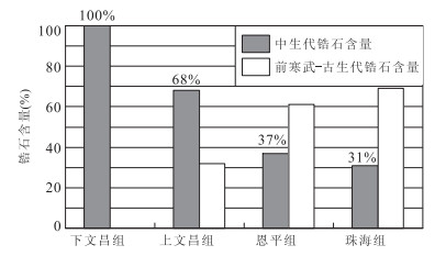
There are plenty of oil in Xihu depression of East China Sea basin, however, few scholars pay attention to the origin and genesis of oil. The samples of source rocks and oil were measured by gas chromatography and Fourier transform infrared spectroscopy (FTIR), and the origin of oil and genesis of condensate and high-wax light oil are discussed based on the analysis of geochemical characteristics. The results suggest that coal measure source rocks of the Pinghu Formation are at the mature stage of thermal evolution. Carbonaceous mudstone and coal mainly came from terrestrial organism, with kerogen type Ⅲ. Dark mudstone mainly came from both terrestrial organism and aquatic organism, with kerogen type Ⅱ-Ⅲ. Genetic potential of carbonaceous mudstone and coal is significantly higher than that of mudstone. The crude oil is mainly divided into condensate with low density and wax and high-wax light oil, and light hydrocarbon displays obvious different compositions. Most of the oil is of humic type with some oil being both humic and sapropelic. Oil is at the medium mature stage. Most oil is derived from carbonaceous mudstone and coal in the Pinghu Formation, whereas only a small amount of oil is derived from dark mudstone. Physical properties of condensate and light oil and their difference of light hydrocarbon composition are unrelated with source rocks. Condensate was produced under the evaporation fractionation effect and from the oil which had been generated from the kerogen at the mature stage. High-wax light oil is residual oil from evaporation fractionation effect, and some oil has experienced mixing.
There are plenty of oil in Xihu depression of East China Sea basin, however, few scholars pay attention to the origin and genesis of oil. The samples of source rocks and oil were measured by gas chromatography and Fourier transform infrared spectroscopy (FTIR), and the origin of oil and genesis of condensate and high-wax light oil are discussed based on the analysis of geochemical characteristics. The results suggest that coal measure source rocks of the Pinghu Formation are at the mature stage of thermal evolution. Carbonaceous mudstone and coal mainly came from terrestrial organism, with kerogen type Ⅲ. Dark mudstone mainly came from both terrestrial organism and aquatic organism, with kerogen type Ⅱ-Ⅲ. Genetic potential of carbonaceous mudstone and coal is significantly higher than that of mudstone. The crude oil is mainly divided into condensate with low density and wax and high-wax light oil, and light hydrocarbon displays obvious different compositions. Most of the oil is of humic type with some oil being both humic and sapropelic. Oil is at the medium mature stage. Most oil is derived from carbonaceous mudstone and coal in the Pinghu Formation, whereas only a small amount of oil is derived from dark mudstone. Physical properties of condensate and light oil and their difference of light hydrocarbon composition are unrelated with source rocks. Condensate was produced under the evaporation fractionation effect and from the oil which had been generated from the kerogen at the mature stage. High-wax light oil is residual oil from evaporation fractionation effect, and some oil has experienced mixing.


2015, 40(6): 1083-1092.
doi: 10.3799/dqkx.2015.090
Abstract:
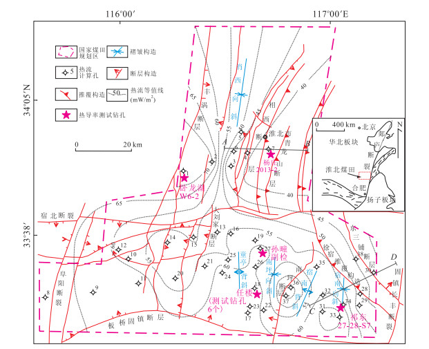
The problem of high temperature in Huaibei coalfield is going to be more and more terrible, however, the research on the characteristics of geothermal field and the distribution of terrestrial heat flow in this region is extremely rare. On the basis of systematical analysis of temperature logging data of surface boreholes and the tested data of temperature of surrounding rock of underground roadway in Huaibei coalfield, combining the tested results of thermal conductivity of 72 rock samples, the current geothermal gradient and terrestrial heat flow in this region are comprehensively expounded. The study shows that the mode of current geothermal gradient in Huaibei coalfield is between 1.80 and 2.80 ℃/100 m and the average is 2.42 ℃/100 m. The terrestrial heat flow value ranges from 39.52 to 74.12 mW/m2 and the average is 55.72 mW/m2. The geothermal gradient and the terrestrial heat flow value are lower than those in Huainan coalfield and other basins in North China. Terrestrial heat flow is controlled by geothermal gradient obviously. The variation of geothermal distribution is similar to the distribution of geothermal gradient and it shows as a whole that the temperature in the south is higher than that in the north and the temperature in the west is also higher than that in the east. The analysis shows that the distribution of current geothermal field and heat flow in the region is mainly controlled by regional geological background and regional tectonic framework.
The problem of high temperature in Huaibei coalfield is going to be more and more terrible, however, the research on the characteristics of geothermal field and the distribution of terrestrial heat flow in this region is extremely rare. On the basis of systematical analysis of temperature logging data of surface boreholes and the tested data of temperature of surrounding rock of underground roadway in Huaibei coalfield, combining the tested results of thermal conductivity of 72 rock samples, the current geothermal gradient and terrestrial heat flow in this region are comprehensively expounded. The study shows that the mode of current geothermal gradient in Huaibei coalfield is between 1.80 and 2.80 ℃/100 m and the average is 2.42 ℃/100 m. The terrestrial heat flow value ranges from 39.52 to 74.12 mW/m2 and the average is 55.72 mW/m2. The geothermal gradient and the terrestrial heat flow value are lower than those in Huainan coalfield and other basins in North China. Terrestrial heat flow is controlled by geothermal gradient obviously. The variation of geothermal distribution is similar to the distribution of geothermal gradient and it shows as a whole that the temperature in the south is higher than that in the north and the temperature in the west is also higher than that in the east. The analysis shows that the distribution of current geothermal field and heat flow in the region is mainly controlled by regional geological background and regional tectonic framework.


2015, 40(6): 1093-1100.
doi: 10.3799/dqkx.2015.091
Abstract:
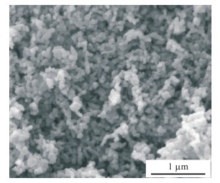
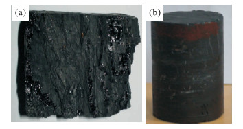
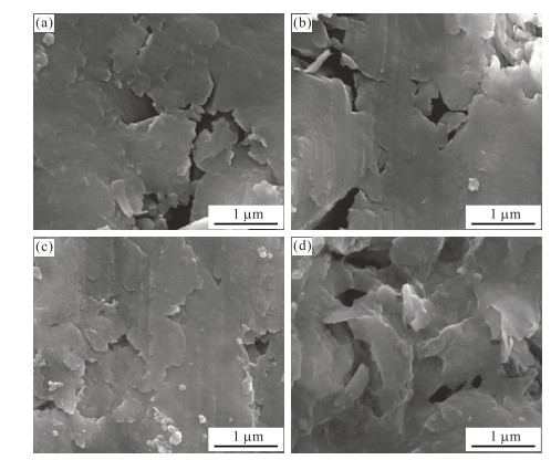
It's difficult to block a mass of nanoscale pores in the low-porosity and low-permeability coalbed methane (CBM) reservoirs using traditional temporary plugging additives. The performances of reducing formation damage to low-porosity and low-permeability CBM reservoirs using calcium carbonate nanoparticles (nCaCO3) are evaluated in this study through microscope investigation of coal rocks, the basic performance tests of drilling fluid, mud cake removal tests, pore size distribution tests and gas permeability tests of coal rocks. It is found that only when nCaCO3 are dispersed to nano-scaled state in water solution could it temporally plug the low permeability coal rocks. However, nCaCO3 based degradable drilling fluid not only blocks the microscale pores in low-porosity and low-permeability coal rock, but also blocks the nanoscale pores. With the double unplugging technology of biological enzyme plus low concentration hydrochloric acid on the nCaCO3 based drilling fluid, the permeability recovery rate of coal rocks ranges from 77.17% to 97.98%. The reservoir protective effect on reservoir proves good. It is shown that the pore size distribution test could be used in the investigation on temporally plugging performance of nanoparticles to low-porosity and low-permeability reservoirs on nanoscale. This study may offer a technical support to facilitate future applications of nCaCO3 in drilling and completion process of low porosity and low permeability coal seams and shale formation.
It's difficult to block a mass of nanoscale pores in the low-porosity and low-permeability coalbed methane (CBM) reservoirs using traditional temporary plugging additives. The performances of reducing formation damage to low-porosity and low-permeability CBM reservoirs using calcium carbonate nanoparticles (nCaCO3) are evaluated in this study through microscope investigation of coal rocks, the basic performance tests of drilling fluid, mud cake removal tests, pore size distribution tests and gas permeability tests of coal rocks. It is found that only when nCaCO3 are dispersed to nano-scaled state in water solution could it temporally plug the low permeability coal rocks. However, nCaCO3 based degradable drilling fluid not only blocks the microscale pores in low-porosity and low-permeability coal rock, but also blocks the nanoscale pores. With the double unplugging technology of biological enzyme plus low concentration hydrochloric acid on the nCaCO3 based drilling fluid, the permeability recovery rate of coal rocks ranges from 77.17% to 97.98%. The reservoir protective effect on reservoir proves good. It is shown that the pore size distribution test could be used in the investigation on temporally plugging performance of nanoparticles to low-porosity and low-permeability reservoirs on nanoscale. This study may offer a technical support to facilitate future applications of nCaCO3 in drilling and completion process of low porosity and low permeability coal seams and shale formation.


2015, 40(6): 1101-1106.
doi: 10.3799/dqkx.2015.092
Abstract:
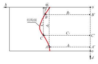
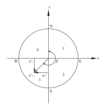
The rock mass mechanical properties and stability of rock engineering are remarkably affected by the occurrence of rock discontinuities. The relative 2D coordinates (d, h) of three non-collinear points at the discontinuity can be accurately derived from setting-out sketch of TV picture of borehole wall. The relative 3D coordinates (x, y, z) of these points and the normal vector of the plane which are determined by them can be obtained using space analytic geometry method., The z-axis and y-axis are rotated toward vertical (z′-axis) and north direction (y′-axis) respectively according to the space geometric relationship of borehole wall and the occurrence of slope and discontinuity without changing the original point and using space coordinate transformation, and the new normal vector of discontinuity in transformed 3D coordinates can also be obtained. Based on the dependency of normal vector, inclination direction and dip angle of discontinuities, a 3D geometrical model can be established, by which the local discontinuity occurrence of any borehole on any flat slope can be determined efficiently.
The rock mass mechanical properties and stability of rock engineering are remarkably affected by the occurrence of rock discontinuities. The relative 2D coordinates (d, h) of three non-collinear points at the discontinuity can be accurately derived from setting-out sketch of TV picture of borehole wall. The relative 3D coordinates (x, y, z) of these points and the normal vector of the plane which are determined by them can be obtained using space analytic geometry method., The z-axis and y-axis are rotated toward vertical (z′-axis) and north direction (y′-axis) respectively according to the space geometric relationship of borehole wall and the occurrence of slope and discontinuity without changing the original point and using space coordinate transformation, and the new normal vector of discontinuity in transformed 3D coordinates can also be obtained. Based on the dependency of normal vector, inclination direction and dip angle of discontinuities, a 3D geometrical model can be established, by which the local discontinuity occurrence of any borehole on any flat slope can be determined efficiently.