2015 Vol. 40, No. 7
Display Method:
 PDF 245KB
2015, 40(7): 1107-1120.
doi: 10.3799/dqkx.2015.093
Abstract:
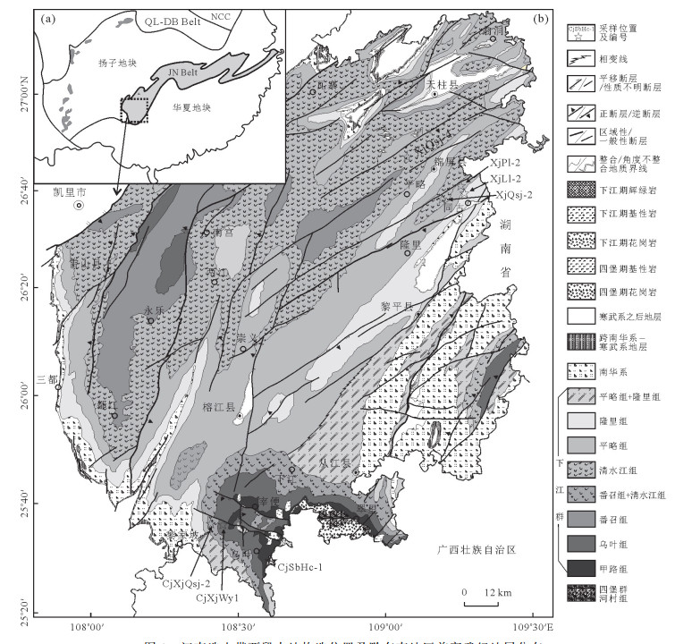
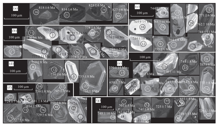
Xiajiang Group in the Southeast Guizhou Province, as the western part of the Jiangnan orogen belt, consists of Precambrian low metamorphic terrisenous clastic sequence interlayer volcaniclastic rocks. But its age and stratigraphic correlation of the Precambrian are still controversial due to absence of lithologic marked bed and fossils and insufficient geochronological data. On the basis of detailed regional geology mapping of the sections, and zircon LA-ICP-MS geochronological study on tuff, tuffaceous and clastic rock of the Precambrian stratum in the study area, high resolution geological data to constrain the age of the Sibao and Xiajiang groups were obtained. It is found that the youngest weighted average ages of 819.8±6.4Ma from the clastic rock at the top of the Hechun Fm., Sibao Gp., for constraining the boundary age between the Sibao and Xiajiang groups. The Xiajiang Gp. can be divided into Wuye, Qingshuijiang, Pinglue and Longli formations from bottom to top. Tuffaceous clastic samples collected from each of the formation yield a series of age (779.5Ma, 764.0-756.0Ma, 733.9Ma and 725.0Ma) to represent the sedimentary times of these four formations. Based on these data, it is proposed that the depositional age of the Xiajiang and Sibao groups is limited to the Neoproterozoic. Combined with the field observation that the Longli and Chang'an formations are continuous deposits and the global low latitude glaciation event of Nanhuaian began from 717.4Ma, the sedimentary time of the Xiajiang Group can be constrained from 815Ma to 717Ma. Besides, the regional magmatic events further constrain the ages of the formations in the Xiajiang Group. The division and the stratigraphic correlation of the Xiajiang Group and the coeval strata help us to comprehend the evolution of the Xiajiang basin.
Xiajiang Group in the Southeast Guizhou Province, as the western part of the Jiangnan orogen belt, consists of Precambrian low metamorphic terrisenous clastic sequence interlayer volcaniclastic rocks. But its age and stratigraphic correlation of the Precambrian are still controversial due to absence of lithologic marked bed and fossils and insufficient geochronological data. On the basis of detailed regional geology mapping of the sections, and zircon LA-ICP-MS geochronological study on tuff, tuffaceous and clastic rock of the Precambrian stratum in the study area, high resolution geological data to constrain the age of the Sibao and Xiajiang groups were obtained. It is found that the youngest weighted average ages of 819.8±6.4Ma from the clastic rock at the top of the Hechun Fm., Sibao Gp., for constraining the boundary age between the Sibao and Xiajiang groups. The Xiajiang Gp. can be divided into Wuye, Qingshuijiang, Pinglue and Longli formations from bottom to top. Tuffaceous clastic samples collected from each of the formation yield a series of age (779.5Ma, 764.0-756.0Ma, 733.9Ma and 725.0Ma) to represent the sedimentary times of these four formations. Based on these data, it is proposed that the depositional age of the Xiajiang and Sibao groups is limited to the Neoproterozoic. Combined with the field observation that the Longli and Chang'an formations are continuous deposits and the global low latitude glaciation event of Nanhuaian began from 717.4Ma, the sedimentary time of the Xiajiang Group can be constrained from 815Ma to 717Ma. Besides, the regional magmatic events further constrain the ages of the formations in the Xiajiang Group. The division and the stratigraphic correlation of the Xiajiang Group and the coeval strata help us to comprehend the evolution of the Xiajiang basin.


2015, 40(7): 1121-1128.
doi: 10.3799/dqkx.2015.094
Abstract:
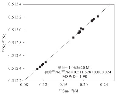
A series of strongly-deformed mafic-ultramafic rocks occur at the Kongling high-grade metamorphic terrain in Yangtze continental nucleus, scattering in the Miaowan Formation in layers and podiforms. This metamafic-ultramafic rock association is of great significance to the early tectonic evolution of Yantgze block. In this study, ID-TIMS whole-rock Sm-Nd isochron dating is carried out for the serpentinized harzburgite and amphibolite from this rock suite. The results indicate that the serpentinized harzburgite was formed at 1063±12Ma, showing that it is feasible to date tiny amount of heavily-altered ultramafic rocks by means of the Sm-Nd isotopic system. The comparatively uniform Nd isotopic composition (with εNd(t) value ranging from 6.90 to 7.32) indicates that they were formed in a closed system. Two-stage Nd modal age of 1.13-1.09Ga is close to their emplacement time, implying an origin of partial melting from depleted asthenospheric mantle. Combined with documented work on late Mesoproterozoic to early Neoproterozoic tectonic-magmatic events in the area, it is suggested that the Yangtze block may have been composed of several microcontinents at that time. There could have been an ocean separating the Yangtze continental nucleus from western Yangtze continental segment.
A series of strongly-deformed mafic-ultramafic rocks occur at the Kongling high-grade metamorphic terrain in Yangtze continental nucleus, scattering in the Miaowan Formation in layers and podiforms. This metamafic-ultramafic rock association is of great significance to the early tectonic evolution of Yantgze block. In this study, ID-TIMS whole-rock Sm-Nd isochron dating is carried out for the serpentinized harzburgite and amphibolite from this rock suite. The results indicate that the serpentinized harzburgite was formed at 1063±12Ma, showing that it is feasible to date tiny amount of heavily-altered ultramafic rocks by means of the Sm-Nd isotopic system. The comparatively uniform Nd isotopic composition (with εNd(t) value ranging from 6.90 to 7.32) indicates that they were formed in a closed system. Two-stage Nd modal age of 1.13-1.09Ga is close to their emplacement time, implying an origin of partial melting from depleted asthenospheric mantle. Combined with documented work on late Mesoproterozoic to early Neoproterozoic tectonic-magmatic events in the area, it is suggested that the Yangtze block may have been composed of several microcontinents at that time. There could have been an ocean separating the Yangtze continental nucleus from western Yangtze continental segment.


2015, 40(7): 1129-1147.
doi: 10.3799/dqkx.2015.095
Abstract:
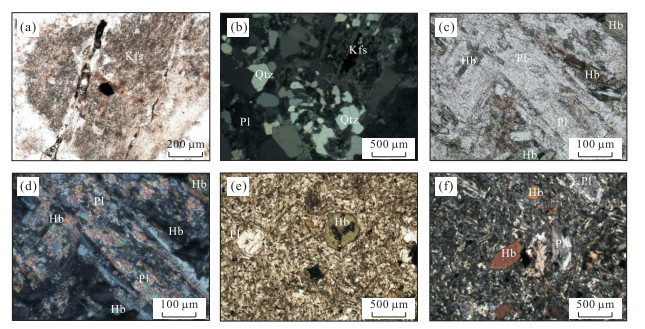
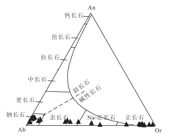
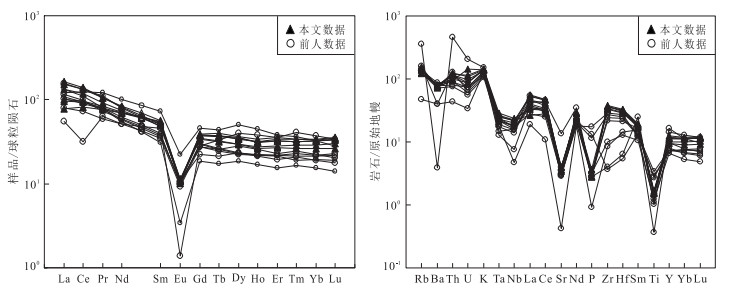
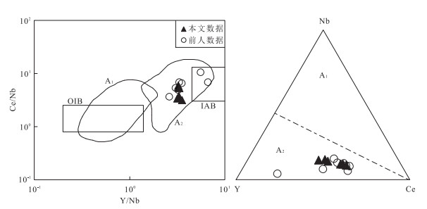
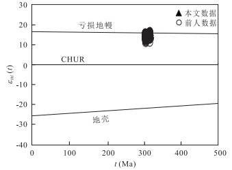
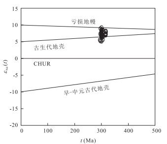
The basement of Junggar basin has been disputed for years, the geochemical characteristics of the granites are indicative of the lower crust, our research shows that, the Hongshan alkali feldspar granites from the West Junggar region, Xingjiang, are characterized by high SiO2, low Al2O3, high total alkali, metalumious, and LREE along with significant negative Eu anomalies, enrichment of large ion lithophile elements (such as Th, Rb and K) and high field-strength elements (such as Zr and Hf), strong depletion of Sr, Ba, P and Ti, showing geochemical features reminiscent of A-type granites. It can further infer that it was formed in post-collisional extensional environment. Zircon U-Pb dating by SIMS and LA-ICP-MS yield ages of 315.7±2.4Ma and 317.8±3.8Ma, suggesting that the pluton was emplaced at early Late Carboniferous, which is contemporary with the timing of the Late Paleozoic post-collisional magmatism in the region. Mineral thermometry implies that the pluton formed at a temperature from 680 to 860℃. On the other hand, zircon Lu-Hf and Sr-Nd isotopic features show a depleted mantle-like signature, suggesting that the magma was sourced from juvenile crust.
The basement of Junggar basin has been disputed for years, the geochemical characteristics of the granites are indicative of the lower crust, our research shows that, the Hongshan alkali feldspar granites from the West Junggar region, Xingjiang, are characterized by high SiO2, low Al2O3, high total alkali, metalumious, and LREE along with significant negative Eu anomalies, enrichment of large ion lithophile elements (such as Th, Rb and K) and high field-strength elements (such as Zr and Hf), strong depletion of Sr, Ba, P and Ti, showing geochemical features reminiscent of A-type granites. It can further infer that it was formed in post-collisional extensional environment. Zircon U-Pb dating by SIMS and LA-ICP-MS yield ages of 315.7±2.4Ma and 317.8±3.8Ma, suggesting that the pluton was emplaced at early Late Carboniferous, which is contemporary with the timing of the Late Paleozoic post-collisional magmatism in the region. Mineral thermometry implies that the pluton formed at a temperature from 680 to 860℃. On the other hand, zircon Lu-Hf and Sr-Nd isotopic features show a depleted mantle-like signature, suggesting that the magma was sourced from juvenile crust.


2015, 40(7): 1148-1162.
doi: 10.3799/dqkx.2015.096
Abstract:
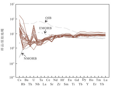
OIB-type basalts outcropped in the Buqingshan tectonic mélange belt, southern margin of East Kunlun, are closely related to mantle plume petrogeneticly. The MOR-type basalts are also another types of seamount basalts developed in the Paleotethys ocean. The Delisitannan basalts in Buqinshan area are located in the southern margin of the East Kunlun region. Field investigations show that the basalts are composed of pillow basalts, fumarolic-amygdaloidal basalts, breccia basalts and massive basalts, which are covered by lamellar fuchsia silicon mudstone. Geochemical data show that the basalts are subdivided into abyssal tholeiite and oceanic ridge tholeiite series. The contents of REE range from 34.51×10⁻⁶-61.60×10⁻⁶, LREE/HREE=0.89-1.37, (La/Yb)N=0.30-0.56. The chondrite-normalized REE pattern shows left-dipped incline and weak negative Eu abnormity (δEu=0.90-1.18), which is identical to NMORB REE distribution pattern. The Delisitannan basalts are aschistic in HSFE (Nb, Ta, Zr, Hf), and Zr/Nb ratios range from 24.59-57.69, Nb/La ratios range from 0.45-0.94, Hf/Ta ratio ranges from 18.29-31.94, which are all similar to those of NMORB basalts, and are obviously different from EMORB and OIB basalts. All of the trace element characteristics indicate that the basalts formed in an NMORB tectonic environment. The petrogenesis study shows that the rocks originated from depleted mantle, and are the product of 10% partial melting of mantle lherzolite roughly.
OIB-type basalts outcropped in the Buqingshan tectonic mélange belt, southern margin of East Kunlun, are closely related to mantle plume petrogeneticly. The MOR-type basalts are also another types of seamount basalts developed in the Paleotethys ocean. The Delisitannan basalts in Buqinshan area are located in the southern margin of the East Kunlun region. Field investigations show that the basalts are composed of pillow basalts, fumarolic-amygdaloidal basalts, breccia basalts and massive basalts, which are covered by lamellar fuchsia silicon mudstone. Geochemical data show that the basalts are subdivided into abyssal tholeiite and oceanic ridge tholeiite series. The contents of REE range from 34.51×10⁻⁶-61.60×10⁻⁶, LREE/HREE=0.89-1.37, (La/Yb)N=0.30-0.56. The chondrite-normalized REE pattern shows left-dipped incline and weak negative Eu abnormity (δEu=0.90-1.18), which is identical to NMORB REE distribution pattern. The Delisitannan basalts are aschistic in HSFE (Nb, Ta, Zr, Hf), and Zr/Nb ratios range from 24.59-57.69, Nb/La ratios range from 0.45-0.94, Hf/Ta ratio ranges from 18.29-31.94, which are all similar to those of NMORB basalts, and are obviously different from EMORB and OIB basalts. All of the trace element characteristics indicate that the basalts formed in an NMORB tectonic environment. The petrogenesis study shows that the rocks originated from depleted mantle, and are the product of 10% partial melting of mantle lherzolite roughly.


2015, 40(7): 1163-1176.
doi: 10.3799/dqkx.2015.097
Abstract:
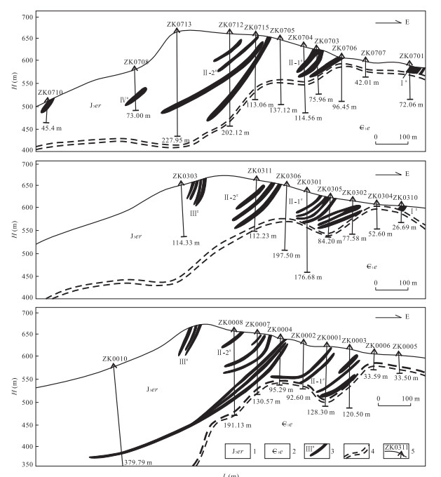
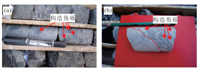
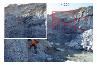
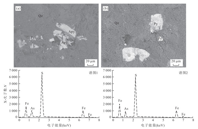
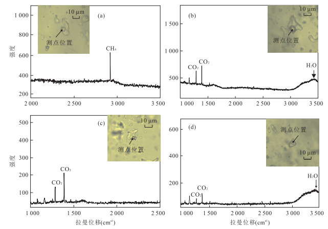
Uncertainty of genesis and ore-controlling condition are always the key restriction of ore-search breakthrough to Shabaosi gold deposit. For the metallogenic background, most scholars believe that it formed in the compressional setting of orogenic process, but few observe that related to the extensional tectonic system. In order to re-determine the genesis of Shabaosi gold deposit, ore-controlling structure, characteristics of ore-forming fluid and source of ore-forming materials are studied in this paper based on the detailed field investigation. The results of the study show that the ore bodies occuring in the tensional fractures are controlled by the large-scale detachment fault. As-bearing pyrite is discovered by SEM for the first time born with arsenopyrite and pyrite in the early metallogenic stage, which indicates that Shabaosi gold deposit formed in mesothermal or slightly meso-hypothermal environment. Fluid inclusions in quartz grains are well developed mainly in gas-liquid phase. The fluid of major metallogenic stage is characterized by moderate homogenization temperature (peak 200-260℃), low salinity (average 5.56 % NaCl equiv.) and low density (average 0.87g/cm3). Bubbles (vapor-phase) of the ore-forming fluid, belonging to H2O-CO2-CH4 system, are mainly composed of H2O, CO2 and CH4. The sulphur are mainly derived from the magma with the δ34S of pyrite in the early metallogenic stage ranges of -1.3‰ to 5.6‰, while a little are from strata. The salinity of ore-forming fluid descends as the temperature reduces. The mixing of different fluids leads the precipitation of ore-forming materials. Comprehensive studies suggest that Shabaosi gold deposit belongs to mesothermal vein gold deposit controlled by detachment fault, which is related to the tectonic setting of intensive crustal extension and the crust evolution involving enormous mantle derived materials in the late Yanshanian period.
Uncertainty of genesis and ore-controlling condition are always the key restriction of ore-search breakthrough to Shabaosi gold deposit. For the metallogenic background, most scholars believe that it formed in the compressional setting of orogenic process, but few observe that related to the extensional tectonic system. In order to re-determine the genesis of Shabaosi gold deposit, ore-controlling structure, characteristics of ore-forming fluid and source of ore-forming materials are studied in this paper based on the detailed field investigation. The results of the study show that the ore bodies occuring in the tensional fractures are controlled by the large-scale detachment fault. As-bearing pyrite is discovered by SEM for the first time born with arsenopyrite and pyrite in the early metallogenic stage, which indicates that Shabaosi gold deposit formed in mesothermal or slightly meso-hypothermal environment. Fluid inclusions in quartz grains are well developed mainly in gas-liquid phase. The fluid of major metallogenic stage is characterized by moderate homogenization temperature (peak 200-260℃), low salinity (average 5.56 % NaCl equiv.) and low density (average 0.87g/cm3). Bubbles (vapor-phase) of the ore-forming fluid, belonging to H2O-CO2-CH4 system, are mainly composed of H2O, CO2 and CH4. The sulphur are mainly derived from the magma with the δ34S of pyrite in the early metallogenic stage ranges of -1.3‰ to 5.6‰, while a little are from strata. The salinity of ore-forming fluid descends as the temperature reduces. The mixing of different fluids leads the precipitation of ore-forming materials. Comprehensive studies suggest that Shabaosi gold deposit belongs to mesothermal vein gold deposit controlled by detachment fault, which is related to the tectonic setting of intensive crustal extension and the crust evolution involving enormous mantle derived materials in the late Yanshanian period.


2015, 40(7): 1177-1186.
doi: 10.3799/dqkx.2015.098
Abstract:
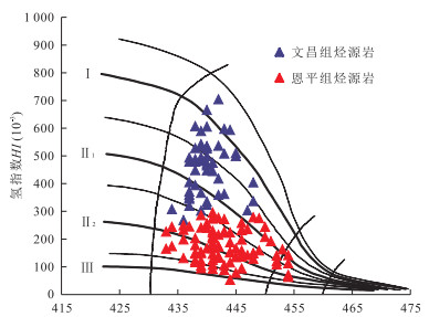
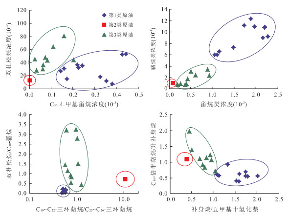
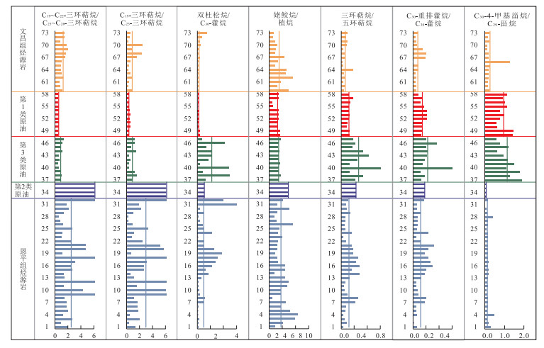
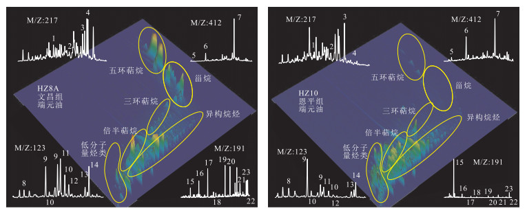
Study of the contribution from Enping Formation to oil accumulation in Zhuyi depression has an important application value to the enlargement of exploration area and the discovery of new reserves, and the related research is less. In this paper, the correlation of oil and source rock in Zhu Ⅰ depression, Pearl River Mouth Basin is discussed first, and then the relative contribution of source rock in the Eocene to Oligocene Enping Formation (Ee) was investigated by combining end-member oil mixing experiment and biomarkers absolute concentrations. Oil-source correlation results show that the oils in Zhu Ⅰ depression can be divided into three classes. The first class derived from Eocene deep-water lacustrine Wenchang Formation (Ew) mainly distributes in Huilu low uplift, Panyu 4 sag and Liuhua uplift, etc. The second class derived from the Ee distributes only in the northern of Huizhou sag. The third class (mixed oils) derived from both the Ew and the Ee distributes in the southern of Huizhou sag and Enping sag. End-member oil mixing experiment shows that the plate established by concentration and geochemical indexes, such as steranes and terpanes concentration, was suitable to indicate the relative contribution of two types of source rock in Zhu Ⅰ depression. Results show that mudstones in the Ew was the main source rock in Zhu Ⅰ depression, the relative contribution of the Ee is only appear in the Huizhou sag and Enping sag.
Study of the contribution from Enping Formation to oil accumulation in Zhuyi depression has an important application value to the enlargement of exploration area and the discovery of new reserves, and the related research is less. In this paper, the correlation of oil and source rock in Zhu Ⅰ depression, Pearl River Mouth Basin is discussed first, and then the relative contribution of source rock in the Eocene to Oligocene Enping Formation (Ee) was investigated by combining end-member oil mixing experiment and biomarkers absolute concentrations. Oil-source correlation results show that the oils in Zhu Ⅰ depression can be divided into three classes. The first class derived from Eocene deep-water lacustrine Wenchang Formation (Ew) mainly distributes in Huilu low uplift, Panyu 4 sag and Liuhua uplift, etc. The second class derived from the Ee distributes only in the northern of Huizhou sag. The third class (mixed oils) derived from both the Ew and the Ee distributes in the southern of Huizhou sag and Enping sag. End-member oil mixing experiment shows that the plate established by concentration and geochemical indexes, such as steranes and terpanes concentration, was suitable to indicate the relative contribution of two types of source rock in Zhu Ⅰ depression. Results show that mudstones in the Ew was the main source rock in Zhu Ⅰ depression, the relative contribution of the Ee is only appear in the Huizhou sag and Enping sag.


2015, 40(7): 1187-1196.
doi: 10.3799/dqkx.2015.099
Abstract:
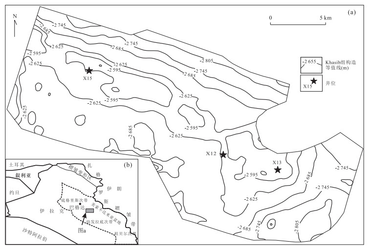
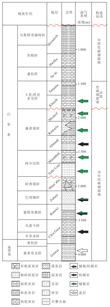
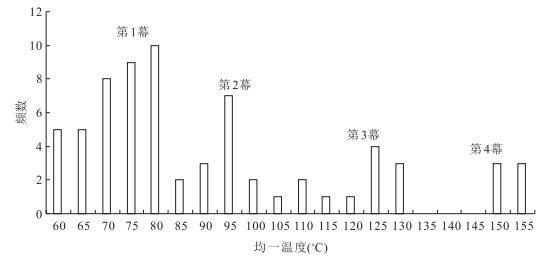
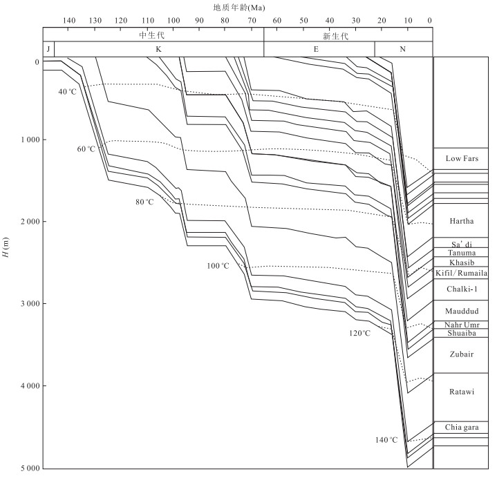
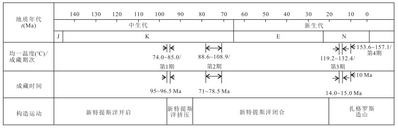
The uncertainty of pool-forming rule of AHDEB oilfield in Iraq has influenced the oilfiled development. Combining with burial history, the study of fluid inclusion is effective to reveal the hydrocarbon charging period and time. The samples collected from Cretaceous reservoirs of AHDEB oil field in Iraq were used to study the characteristics of fluid inclusion. Based on the observation of thin sections and the fluorescence color, measurement of μFT-IR and homogenization temperature, combining with analysis of geologic setting, the hydrocarbon charging periods were researched. The results show that the fluorescence colors of oil inclusion were mainly green and yellow-green, while minor light yellow and yellowish-brown. It is found by the measurement of μFT-IR of oil inclusion that there are 2 types of maturity based on the value of CH2a/CH3a, Xinc and Xstd. The data of burial history, thermal evolution history and the homogenization temperature indicate that there might be four terms of oil accumulation. The first term of oil charging occurred at 95.0-96.5Ma, equivalent to early Late-Cretaceous, and the second term occurred at 71.0-78.5Ma, equivalent to late Late-Cretaceous, which were consistent with the small scale of hydrocarbon generation by producing heavy oil that in turn was oxidized to asphalt. The third term of oil charging occurred at 14.0-15.0Ma, equivalently Middle Miocene, which was the main accumulation, being consistent with the peak of hydrocarbon generation. The forth term occurred at 10.0Ma, which was the charging event related to the third term.
The uncertainty of pool-forming rule of AHDEB oilfield in Iraq has influenced the oilfiled development. Combining with burial history, the study of fluid inclusion is effective to reveal the hydrocarbon charging period and time. The samples collected from Cretaceous reservoirs of AHDEB oil field in Iraq were used to study the characteristics of fluid inclusion. Based on the observation of thin sections and the fluorescence color, measurement of μFT-IR and homogenization temperature, combining with analysis of geologic setting, the hydrocarbon charging periods were researched. The results show that the fluorescence colors of oil inclusion were mainly green and yellow-green, while minor light yellow and yellowish-brown. It is found by the measurement of μFT-IR of oil inclusion that there are 2 types of maturity based on the value of CH2a/CH3a, Xinc and Xstd. The data of burial history, thermal evolution history and the homogenization temperature indicate that there might be four terms of oil accumulation. The first term of oil charging occurred at 95.0-96.5Ma, equivalent to early Late-Cretaceous, and the second term occurred at 71.0-78.5Ma, equivalent to late Late-Cretaceous, which were consistent with the small scale of hydrocarbon generation by producing heavy oil that in turn was oxidized to asphalt. The third term of oil charging occurred at 14.0-15.0Ma, equivalently Middle Miocene, which was the main accumulation, being consistent with the peak of hydrocarbon generation. The forth term occurred at 10.0Ma, which was the charging event related to the third term.


2015, 40(7): 1197-1214.
doi: 10.3799/dqkx.2015.100
Abstract:
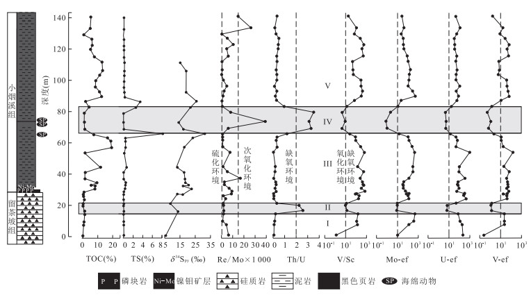
The evolution of atmospheric and oceanic oxygen content played an important role in the metazoans' radiation around Ediacaran-Cambrian transition. To explore the vertical stratigraphic evolution and controls of the redox ocean state, primary productivity and seawater sulfate levels during the Terreneuvian epoch, South China, Lijiatuo section, a well-exposed one that is located in the slope and basin environment and consists of mudstones of Xiaoyanxi Formation and cherts of Liuchapo Formation, is selected as the study area for an in-depth analysis of the trace elements, total organic carbon(TOC), organic carbon isotopes, total sulfur(TS) and the sulfur isotope of the pyrite. Based on the ratios of V/Sc, Th/U and the enrichment factors of Mo, U, V, Ni and Cu in the Lijiatuo section, five oxic-anoxic cycles are identified across the Terreneuvian epoch. Except for the middle-upper Liuchapo Formation and the middle Xiaoyanxi Formation, the rest parts of the Lijiatuo section are under anoxic conditions. The Re/Mo ratios demonstrate that the oxic environment of the middle Xiaoyanxi Formation is accompanied by transient sulfidic conditions, and the rest parts of the section are under anoxic and non-sulfidic conditions. All the TOC and the enrichment factors of Ba, Ni, Cu, Zn and Cd demonstrate that both the sink and burial flux of organic matter of Liuchapo Formation are lower than those of the overlying Xiaoyanxi Formation. The highest sink and burial fluxes of organic matter in the Xiaoyanxi Formation appeare in its lower parts, however, whereas the lowest sink and burial fluxes of organic matter in the Xiaoyanxi Formation appeare in its middle parts. The proxies of TOC/TS, TS and the vertical trend of sulfur isotope of pyrite show that the majority of the Lijiatuo section is under low seawater sulfate levels. The low seawater sulfate level was the dominating control for the depletion of free H2S in the majority of the anoxic depositional environment of Lijiatuo section during Terreneuvian epoch. The rise of the atmospheric oxygen content was the principal driver for the coupled, transient oxic and near sulfidic environment in the middle Xiaoyanxi Formation.
The evolution of atmospheric and oceanic oxygen content played an important role in the metazoans' radiation around Ediacaran-Cambrian transition. To explore the vertical stratigraphic evolution and controls of the redox ocean state, primary productivity and seawater sulfate levels during the Terreneuvian epoch, South China, Lijiatuo section, a well-exposed one that is located in the slope and basin environment and consists of mudstones of Xiaoyanxi Formation and cherts of Liuchapo Formation, is selected as the study area for an in-depth analysis of the trace elements, total organic carbon(TOC), organic carbon isotopes, total sulfur(TS) and the sulfur isotope of the pyrite. Based on the ratios of V/Sc, Th/U and the enrichment factors of Mo, U, V, Ni and Cu in the Lijiatuo section, five oxic-anoxic cycles are identified across the Terreneuvian epoch. Except for the middle-upper Liuchapo Formation and the middle Xiaoyanxi Formation, the rest parts of the Lijiatuo section are under anoxic conditions. The Re/Mo ratios demonstrate that the oxic environment of the middle Xiaoyanxi Formation is accompanied by transient sulfidic conditions, and the rest parts of the section are under anoxic and non-sulfidic conditions. All the TOC and the enrichment factors of Ba, Ni, Cu, Zn and Cd demonstrate that both the sink and burial flux of organic matter of Liuchapo Formation are lower than those of the overlying Xiaoyanxi Formation. The highest sink and burial fluxes of organic matter in the Xiaoyanxi Formation appeare in its lower parts, however, whereas the lowest sink and burial fluxes of organic matter in the Xiaoyanxi Formation appeare in its middle parts. The proxies of TOC/TS, TS and the vertical trend of sulfur isotope of pyrite show that the majority of the Lijiatuo section is under low seawater sulfate levels. The low seawater sulfate level was the dominating control for the depletion of free H2S in the majority of the anoxic depositional environment of Lijiatuo section during Terreneuvian epoch. The rise of the atmospheric oxygen content was the principal driver for the coupled, transient oxic and near sulfidic environment in the middle Xiaoyanxi Formation.


2015, 40(7): 1215-1225.
doi: 10.3799/dqkx.2015.101
Abstract:
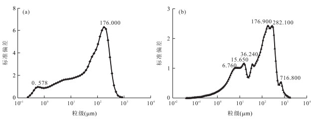
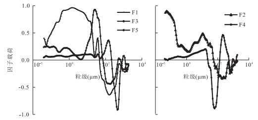
Sediment environment sensitive granularity is one of the important methods of the ancient environment study, but there are very few complete quaternary sediment core deep hole to extract environmentally sensitive granularity component and analysis in the north China plain regions. Grain size versus standard deviation, and principal component analyses have been applied to extract sensitive grain size components from sediment samples of G1 and G2 in Tianjin Bohai bay. Comparison of extraction results of the two methods shows both differences and compatibility. The thinner the thickness of sediment bedding is, the more obvious the compatibility is. It is found that principal component analyses can provide better description while grain size versus standard deviation is not suitable for the deep hole extraction. Six and three environmentally sensitive granularity component peaks appear in G1 and G2 holes, which are 6.70μm, 15.65μm, 36.24μm, 176.90μm, 282.10μm, 716.80μm for G1, 0.578μm and 176.000μm for G2 respectively, indicating different sediment sources and sedimentary spatial environment for G1 and G2. Compared with G1 hole, the sedimentary environment of G2 is more stable with stronger deposit strength, which can be used to reconstruct the palaeoenvironment.
Sediment environment sensitive granularity is one of the important methods of the ancient environment study, but there are very few complete quaternary sediment core deep hole to extract environmentally sensitive granularity component and analysis in the north China plain regions. Grain size versus standard deviation, and principal component analyses have been applied to extract sensitive grain size components from sediment samples of G1 and G2 in Tianjin Bohai bay. Comparison of extraction results of the two methods shows both differences and compatibility. The thinner the thickness of sediment bedding is, the more obvious the compatibility is. It is found that principal component analyses can provide better description while grain size versus standard deviation is not suitable for the deep hole extraction. Six and three environmentally sensitive granularity component peaks appear in G1 and G2 holes, which are 6.70μm, 15.65μm, 36.24μm, 176.90μm, 282.10μm, 716.80μm for G1, 0.578μm and 176.000μm for G2 respectively, indicating different sediment sources and sedimentary spatial environment for G1 and G2. Compared with G1 hole, the sedimentary environment of G2 is more stable with stronger deposit strength, which can be used to reconstruct the palaeoenvironment.


2015, 40(7): 1226-1236.
doi: 10.3799/dqkx.2015.102
Abstract:
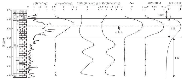
As a reliable proxy for paleoclimate and paleoenvironment, magnetic parameter could provide valuable data for the research of global environmental changes and climatic processes. A detailed study has been carried out on rock magnetism in order to reveal the change of climate and environment and its reasons across Guadalupian-Lopingian (G-L) boundary at Tieqiao section in Laibin area, Guangxi, China. The results show that the dominant magnetic minerals from Tieqiao section are paramagnetic minerals with a small amount of magnetite and hematite as well. There is a remarkable change in the properties of rock magnetism near the G-L boundary. Magnetic susceptibility increases first and then decreases. Magnetic carriers show the trend of being transformed from hard magnetic minerals (hematite) to soft magnetic mineral (magnetite) and then turning to hard magnetic minerals (hematite). All of these changes occur within 4m-thick strata interval above and below the G-L boundary, and synchronize with the fluctuation of sea-level and ancient seawater temperature during late Middle Permian. The significant changes in magnetic parameters for Middle-Late Permian carbonates suggest that the migration and conversion of magnetic minerals between different spheres in earth system has shifted, which resulted from the climatic and environmental changes. High sea-level during Late Guadalupian and Early Lopingian resulted in the decrease in terrigenous supply in South China. Therefore, the magnetic carriers in Tieqiao section mainly are hematite through aeolian transportation during this period. However, pronounced regression during the Middle-Late Permian transition led to the expansion of exposed land area. Meanwhile, land plants experienced widespread extinction, which led to increased sediment source. The magnetic carriers in contemporaneous sediments of Tieqiao section are mainly fluvial magnetite.
As a reliable proxy for paleoclimate and paleoenvironment, magnetic parameter could provide valuable data for the research of global environmental changes and climatic processes. A detailed study has been carried out on rock magnetism in order to reveal the change of climate and environment and its reasons across Guadalupian-Lopingian (G-L) boundary at Tieqiao section in Laibin area, Guangxi, China. The results show that the dominant magnetic minerals from Tieqiao section are paramagnetic minerals with a small amount of magnetite and hematite as well. There is a remarkable change in the properties of rock magnetism near the G-L boundary. Magnetic susceptibility increases first and then decreases. Magnetic carriers show the trend of being transformed from hard magnetic minerals (hematite) to soft magnetic mineral (magnetite) and then turning to hard magnetic minerals (hematite). All of these changes occur within 4m-thick strata interval above and below the G-L boundary, and synchronize with the fluctuation of sea-level and ancient seawater temperature during late Middle Permian. The significant changes in magnetic parameters for Middle-Late Permian carbonates suggest that the migration and conversion of magnetic minerals between different spheres in earth system has shifted, which resulted from the climatic and environmental changes. High sea-level during Late Guadalupian and Early Lopingian resulted in the decrease in terrigenous supply in South China. Therefore, the magnetic carriers in Tieqiao section mainly are hematite through aeolian transportation during this period. However, pronounced regression during the Middle-Late Permian transition led to the expansion of exposed land area. Meanwhile, land plants experienced widespread extinction, which led to increased sediment source. The magnetic carriers in contemporaneous sediments of Tieqiao section are mainly fluvial magnetite.


2015, 40(7): 1237-1247.
doi: 10.3799/dqkx.2015.103
Abstract:
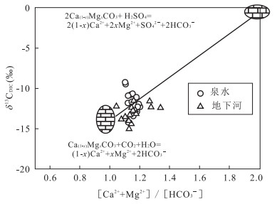
Quantitative evaluation of the impact of sulfuric acid to karst carbon sink not only improves the estimation accuracy of karst carbon sinks, but also facilitates research on global climate change. In this paper, Guilin karst area affected by acid rain is selected for studying. The results of testing and analysis of the chemical composition and inorganic carbon isotope in 14 karst spring and 15 subterraneans show that in both karst spring and subterranean, Mg2+ and Ca2+ are the main negative ions, and HCO3- is the main positive ion, which were accounted for more than 90% of negative ion and positive ion respectively, and SO42- has a lower content, which content range was 0.004-0.213mmol/L and the composition ratio was 0.12%-6.11%; The δ13CDIC, [Ca2++Mg2+]/[HCO3-] are more inclined to carbonate dissolution endmember, and the longer distance from sulfuric acid dissolution endmember indicates the limited impact of sulfuric acid dissolution of carbonate rocks involved in groundwater inorganic carbon (DIC) and δ13CDIC. Same as the situation of Sr2+/Ca2+ values, δ13CDIC could reflect the run-off condition of groundwater to some degree. Using the stoichiometry method calculate, the average proportion of DIC(HCO3-H2SO4) produced by sulfuric acid gained by stoichiometric relationship is 22.64%, accounts for 13.04%, while that produced by carbonic acid accounts for 86.96%, of which 43.48% comes from the soil atmosphere. Deducting DIC contribution of sulfuric acid to the groundwater, 13.04% karst carbon sink will be reduced.
Quantitative evaluation of the impact of sulfuric acid to karst carbon sink not only improves the estimation accuracy of karst carbon sinks, but also facilitates research on global climate change. In this paper, Guilin karst area affected by acid rain is selected for studying. The results of testing and analysis of the chemical composition and inorganic carbon isotope in 14 karst spring and 15 subterraneans show that in both karst spring and subterranean, Mg2+ and Ca2+ are the main negative ions, and HCO3- is the main positive ion, which were accounted for more than 90% of negative ion and positive ion respectively, and SO42- has a lower content, which content range was 0.004-0.213mmol/L and the composition ratio was 0.12%-6.11%; The δ13CDIC, [Ca2++Mg2+]/[HCO3-] are more inclined to carbonate dissolution endmember, and the longer distance from sulfuric acid dissolution endmember indicates the limited impact of sulfuric acid dissolution of carbonate rocks involved in groundwater inorganic carbon (DIC) and δ13CDIC. Same as the situation of Sr2+/Ca2+ values, δ13CDIC could reflect the run-off condition of groundwater to some degree. Using the stoichiometry method calculate, the average proportion of DIC(HCO3-H2SO4) produced by sulfuric acid gained by stoichiometric relationship is 22.64%, accounts for 13.04%, while that produced by carbonic acid accounts for 86.96%, of which 43.48% comes from the soil atmosphere. Deducting DIC contribution of sulfuric acid to the groundwater, 13.04% karst carbon sink will be reduced.


2015, 40(7): 1248-1253.
doi: 10.3799/dqkx.2015.104
Abstract:
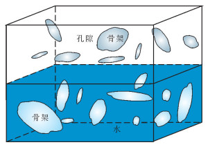
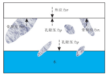
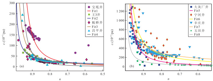
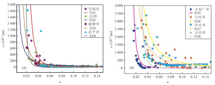
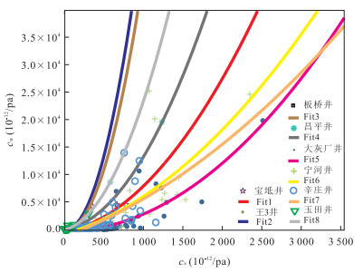
The study of porosity and rock compressibility etc has important application value in the evaluation of the elastic capacity and dynamic geological reserves of the reservoir. Water level digital data of 8 wells provided by the National Earthquake Precursor Network Center are studied to explore the relationship of porosity and volume compression coefficient between solid skeleton and water in artesian well aquifer medium under undrained condition. The results show that there exists a power function relation between the porosity and the solid skeleton volume compression coefficient and water volume compression coefficient in the aquifer. In the first quadrant, each well aquifer solid skeleton volume compression coefficient increases with increasing porosity, whereas the volume compression coefficient of water decreases with the increase of porosity, with one of two quadratic polynomial relationships between the solid skeleton and water volume compression coefficient in the aquifer. The volume compression coefficient of water in the aquifer is larger than that of the solid skeleton, and water is more easily compressed. In addition, the compression coefficient of limestone skeleton is relatively smaller than that of sandstone.
The study of porosity and rock compressibility etc has important application value in the evaluation of the elastic capacity and dynamic geological reserves of the reservoir. Water level digital data of 8 wells provided by the National Earthquake Precursor Network Center are studied to explore the relationship of porosity and volume compression coefficient between solid skeleton and water in artesian well aquifer medium under undrained condition. The results show that there exists a power function relation between the porosity and the solid skeleton volume compression coefficient and water volume compression coefficient in the aquifer. In the first quadrant, each well aquifer solid skeleton volume compression coefficient increases with increasing porosity, whereas the volume compression coefficient of water decreases with the increase of porosity, with one of two quadratic polynomial relationships between the solid skeleton and water volume compression coefficient in the aquifer. The volume compression coefficient of water in the aquifer is larger than that of the solid skeleton, and water is more easily compressed. In addition, the compression coefficient of limestone skeleton is relatively smaller than that of sandstone.
2015, 40(7): 1254-1265.
doi: 10.3799/dqkx.2015.105
Abstract:
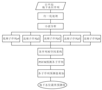
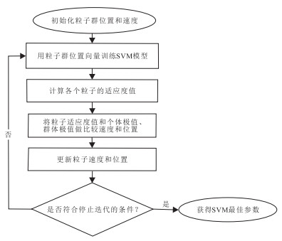
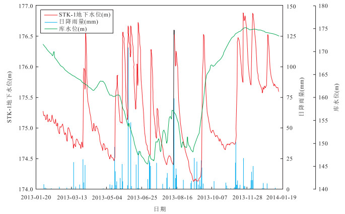
It is of great significance to predict the dynamic evolution process of landslide underground water level for landslide stability analysis. For the problem that the evolution process of groundwater level in reservoir landslide is a highly non-linear and non-stationary time series affected by many factors, to predict landslide groundwater level time series, a coupling model based on phase space reconstruction and wavelet analysis-support vector machine (WA-PSVM) optimized by particle swarm optimization is proposed. Firstly, the groundwater level time series was decomposed into several different frequency components to transform the non-stationary groundwater level time series into stationary time series. Secondly, the PSVM model was established for each component prediction based on the phase-space reconstruction. At last, the final prediction result was obtained by adding the predicted values of all frequency components. Taking daily average groundwater level time series of STK-1 hydrology hole on Sanzhouxi Landslide in the Three Gorges Reservoir Area for example, the influencing factors of landslide groundwater level fluctuation were analyzed and WA-PSVM model was used to predict the STK-1 groundwater level values. Meanwhile, the single PSVM model and wavelet analysis-back propagation neural network (WA-BP) model were also used for groundwater level prediction. The results show that reservoir water level fluctuation and rainfall are the main factors of groundwater level fluctuation in the reservoir landslide leading edge. We also find that the root-mean-square error (RMSE) of the proposed model for groundwater level time series prediction in STK-1 hydrology holes is 0.073m, the goodness of fit is 0.966, respectively. The prediction accuracy of WA-PSVM model is higher than the single PSVM model and WA-BP model. What is more, WA-PSVM model solves the non-linear and non-stationary problem. WA-PSVM model also has a high operating efficiency and strong applicability without considering the impacts of reservoir water level fluctuation and seasonal rainfall.
It is of great significance to predict the dynamic evolution process of landslide underground water level for landslide stability analysis. For the problem that the evolution process of groundwater level in reservoir landslide is a highly non-linear and non-stationary time series affected by many factors, to predict landslide groundwater level time series, a coupling model based on phase space reconstruction and wavelet analysis-support vector machine (WA-PSVM) optimized by particle swarm optimization is proposed. Firstly, the groundwater level time series was decomposed into several different frequency components to transform the non-stationary groundwater level time series into stationary time series. Secondly, the PSVM model was established for each component prediction based on the phase-space reconstruction. At last, the final prediction result was obtained by adding the predicted values of all frequency components. Taking daily average groundwater level time series of STK-1 hydrology hole on Sanzhouxi Landslide in the Three Gorges Reservoir Area for example, the influencing factors of landslide groundwater level fluctuation were analyzed and WA-PSVM model was used to predict the STK-1 groundwater level values. Meanwhile, the single PSVM model and wavelet analysis-back propagation neural network (WA-BP) model were also used for groundwater level prediction. The results show that reservoir water level fluctuation and rainfall are the main factors of groundwater level fluctuation in the reservoir landslide leading edge. We also find that the root-mean-square error (RMSE) of the proposed model for groundwater level time series prediction in STK-1 hydrology holes is 0.073m, the goodness of fit is 0.966, respectively. The prediction accuracy of WA-PSVM model is higher than the single PSVM model and WA-BP model. What is more, WA-PSVM model solves the non-linear and non-stationary problem. WA-PSVM model also has a high operating efficiency and strong applicability without considering the impacts of reservoir water level fluctuation and seasonal rainfall.


2015, 40(7): 1266-1275.
doi: 10.3799/dqkx.2015.106
Abstract:
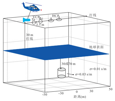
Coils attitude influence and attitude corrections method for frequency domain airborne electromagnetic system are pioneering jobs in frontiers without much experience. The coils of towed helicopter frequency airborne electromagnetic method are mounted in a bird, coils attitude changes a lot relatively, so attitude corrections improve the precision of data processing. It is important to impove data processing level for airborne electromagnetic method. Attitude variations of helicopter bird frequency electromagnetic system transmitting and receiving coils, result in electromagnetic data error which is produced by underground geologic body and received by the electromagnetic sensor. Analog computation is used in this study to work out the frequency domain airborne electromagnetic response by 3D frequency domain finite difference method. The response of horizontal co-plane and vertical coaxial systems from different frequencies and different types of sensor rotation is analyzed. The results show that the measurement error from vertical coaxial system is greater than that of horizontal co-plane system. The measurement error caused by the change of rotation angles is more remarkable than higher frequencies. The vertical coaxial system is mainly affected by pitch rotation, whereas the horizontal co-plane system is mainly affected by roll and pitch rotation, and the latter has great influence in the same rotation angle. On the basis of previous work of calibrating attitude error, this paper effectively wipes out response error from attitude changing of coils.
Coils attitude influence and attitude corrections method for frequency domain airborne electromagnetic system are pioneering jobs in frontiers without much experience. The coils of towed helicopter frequency airborne electromagnetic method are mounted in a bird, coils attitude changes a lot relatively, so attitude corrections improve the precision of data processing. It is important to impove data processing level for airborne electromagnetic method. Attitude variations of helicopter bird frequency electromagnetic system transmitting and receiving coils, result in electromagnetic data error which is produced by underground geologic body and received by the electromagnetic sensor. Analog computation is used in this study to work out the frequency domain airborne electromagnetic response by 3D frequency domain finite difference method. The response of horizontal co-plane and vertical coaxial systems from different frequencies and different types of sensor rotation is analyzed. The results show that the measurement error from vertical coaxial system is greater than that of horizontal co-plane system. The measurement error caused by the change of rotation angles is more remarkable than higher frequencies. The vertical coaxial system is mainly affected by pitch rotation, whereas the horizontal co-plane system is mainly affected by roll and pitch rotation, and the latter has great influence in the same rotation angle. On the basis of previous work of calibrating attitude error, this paper effectively wipes out response error from attitude changing of coils.


2015, 40(7): 1276-1286.
doi: 10.3799/dqkx.2015.107
Abstract:
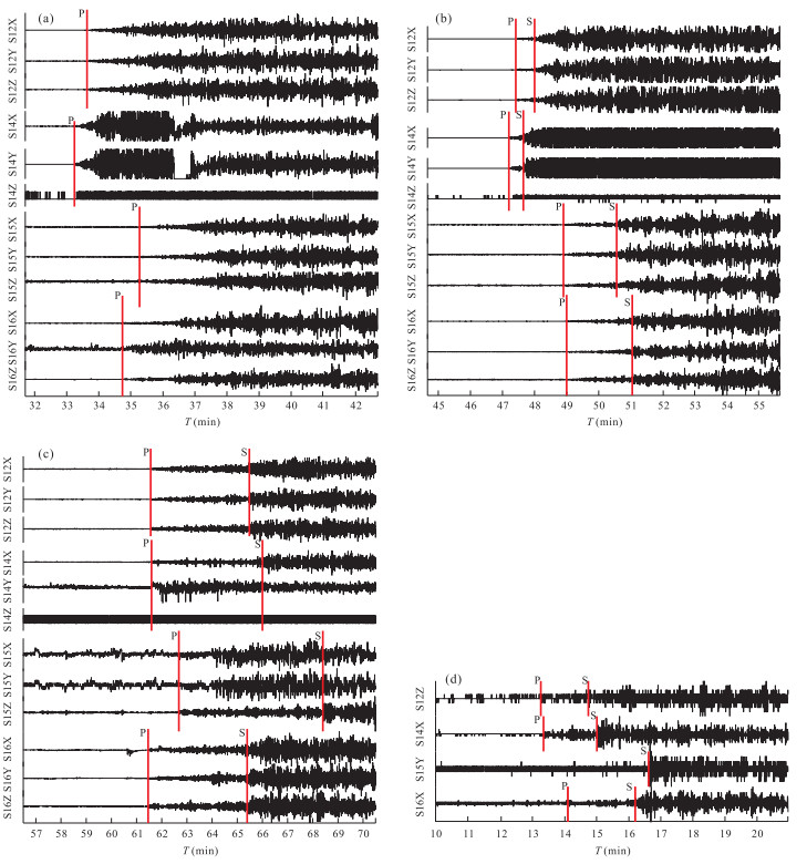
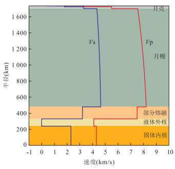
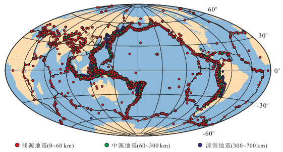
Existing parameters for tomography and relevant research about the moonquakes are not necessarily accurate due to he low precision of moonquake location resulted from outdated velocity models published during last century. However, the accuracy of lunar velocity model and stratigraphic structure has been improved greatly thanks to latest studies on lunar internal structure. This paper selects new arrival times from Apollo moonquake data, and relocates the moonquakes using Geiger method based on the latest lunar velocity model. In addition, the differences of distribution and mechanism between moonquakes and earthquakes are analyzed. This study can offer more information for further research of moonquakes and lunar internal structure.
Existing parameters for tomography and relevant research about the moonquakes are not necessarily accurate due to he low precision of moonquake location resulted from outdated velocity models published during last century. However, the accuracy of lunar velocity model and stratigraphic structure has been improved greatly thanks to latest studies on lunar internal structure. This paper selects new arrival times from Apollo moonquake data, and relocates the moonquakes using Geiger method based on the latest lunar velocity model. In addition, the differences of distribution and mechanism between moonquakes and earthquakes are analyzed. This study can offer more information for further research of moonquakes and lunar internal structure.