2015 Vol. 40, No. 9
Display Method:
 PDF 256KB
2015, 40(9): 1441-1457.
doi: 10.3799/dqkx.2015.131
Abstract:
Understanding about genesis of the Early Permian basic-ultrabasic rocks in the northern margin of North China craton are varied, with one of the influential viewpoints suggesting that they are related with activities of "Andes-type continental margin", which is discussed in this paper based on researches of the cumulates in east Hebei Province. Early Permian basic-ultrabasic cumulates controlled by Fengning-Longhua lithospheric faults are distributed discontinuously in the northern margin of North China craton. The SHRIMP Zircon U-Pb ages from cumulates are 280-300 Ma. Petrographic studies confirm that the complexes consist of a suite of cumulates including dunite, pyroxenite, amphibolite, gabbro, diorite, anorthosite, and so on, which in turn can be further divided into layered and circular ones, both with obvious cumulate texture. Mineralogical studies show that hornblende, pyroxene, and phlogolite in cumulates all are characterized by mantle sourced components of high Mg and high Cr. Sr/Ba ratio of cumulates with different components does not change with their melting degrees, showing that cumulates possess a fractional crystallization trend. Similar REE patterns and transition group elements reveal their consanguinity. Comparison of cumulates of the Late Paleozoic with those of the Early Mesozoic from the concerned area indicates that these Early Permian cumulates have characteristics of an initial-rift magma, which offers the earliest evidence of the transformation from the stable to the active one of continental crust of North China craton. Viewed from broader regions, activities of this period in this area are driven by deeper geodynamics.
Understanding about genesis of the Early Permian basic-ultrabasic rocks in the northern margin of North China craton are varied, with one of the influential viewpoints suggesting that they are related with activities of "Andes-type continental margin", which is discussed in this paper based on researches of the cumulates in east Hebei Province. Early Permian basic-ultrabasic cumulates controlled by Fengning-Longhua lithospheric faults are distributed discontinuously in the northern margin of North China craton. The SHRIMP Zircon U-Pb ages from cumulates are 280-300 Ma. Petrographic studies confirm that the complexes consist of a suite of cumulates including dunite, pyroxenite, amphibolite, gabbro, diorite, anorthosite, and so on, which in turn can be further divided into layered and circular ones, both with obvious cumulate texture. Mineralogical studies show that hornblende, pyroxene, and phlogolite in cumulates all are characterized by mantle sourced components of high Mg and high Cr. Sr/Ba ratio of cumulates with different components does not change with their melting degrees, showing that cumulates possess a fractional crystallization trend. Similar REE patterns and transition group elements reveal their consanguinity. Comparison of cumulates of the Late Paleozoic with those of the Early Mesozoic from the concerned area indicates that these Early Permian cumulates have characteristics of an initial-rift magma, which offers the earliest evidence of the transformation from the stable to the active one of continental crust of North China craton. Viewed from broader regions, activities of this period in this area are driven by deeper geodynamics.


2015, 40(9): 1458-1479.
doi: 10.3799/dqkx.2015.132
Abstract:
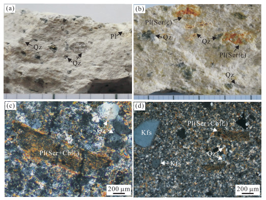
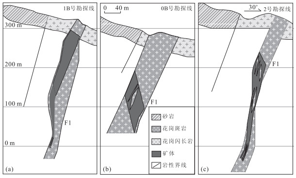
The Qinzhou Bay-Hangzhou Bay suture zone is an important porphyry copper metallogenic belt in southern China. Previous studies suggest that the ages of regional diagenesis and mineralization are mainly concentrated in the Late-Middle Jurassic (180-155 Ma), and the ore-bearing granite porphyry shows distinctly crust-mantle contamination. The Baoshan copper deposit is a porphyry-type Cu deposit newly discovered in the Dayaoshan region in the southwestern of the Qinhang metallogenic belt in recent years. The granite porphyry is dominated as small stock into Sheshan granodiorite, including two outcropped and one concealed magmatic emplacement. And the copper ore body is all hosted in the Baoshan concealed granite porphyry. In this paper, laser ablation (MC)-ICPMS U-Pb dating and Hf isotopic compositions of zircons from three granite porphyry samples in the Baoshan copper deposit are presented. Highly precise U-Pb results indicate that zircons from one concealed and two outcropped granite porphyries give weighted mean 206Pb/238U age of 91.1±0.6 Ma (1σ), 91.3±0.8 Ma (1σ) and 90.1±1.0 Ma (1σ), respectively. And the zircons crystallized in the late Yanshannian granites give εHf (91 Ma) values ranging from -8.74 to -5.13 and Hf model ages (TDM2) of 1 210-1 394 Ma. U-Pb and Hf isotopic data can be interpreted as the crystallization time of these granites and the mineralization age, indicating it was formed in the ~91 Ma and may be developed by reworking of Mesoproterozoic crust closely related to partial melting. Together with other published geochronological data, it is proposed that the late Yanshannian magmatite and related Cu (Au)-W-Mo deposit are widely developed in the Dayaoshan and its adjacent areas. Moreover, two epochs of porphyry copper mineralization are confirmed in this study, including the Middle-Late Jurassic and the Late Cretaceous, in the Qinhang metallogenic belt, and it is concluded that Late Cretaceous mineralization possibly resulted from the post-collisional crustal extension setting in the continental margin of the South China.
The Qinzhou Bay-Hangzhou Bay suture zone is an important porphyry copper metallogenic belt in southern China. Previous studies suggest that the ages of regional diagenesis and mineralization are mainly concentrated in the Late-Middle Jurassic (180-155 Ma), and the ore-bearing granite porphyry shows distinctly crust-mantle contamination. The Baoshan copper deposit is a porphyry-type Cu deposit newly discovered in the Dayaoshan region in the southwestern of the Qinhang metallogenic belt in recent years. The granite porphyry is dominated as small stock into Sheshan granodiorite, including two outcropped and one concealed magmatic emplacement. And the copper ore body is all hosted in the Baoshan concealed granite porphyry. In this paper, laser ablation (MC)-ICPMS U-Pb dating and Hf isotopic compositions of zircons from three granite porphyry samples in the Baoshan copper deposit are presented. Highly precise U-Pb results indicate that zircons from one concealed and two outcropped granite porphyries give weighted mean 206Pb/238U age of 91.1±0.6 Ma (1σ), 91.3±0.8 Ma (1σ) and 90.1±1.0 Ma (1σ), respectively. And the zircons crystallized in the late Yanshannian granites give εHf (91 Ma) values ranging from -8.74 to -5.13 and Hf model ages (TDM2) of 1 210-1 394 Ma. U-Pb and Hf isotopic data can be interpreted as the crystallization time of these granites and the mineralization age, indicating it was formed in the ~91 Ma and may be developed by reworking of Mesoproterozoic crust closely related to partial melting. Together with other published geochronological data, it is proposed that the late Yanshannian magmatite and related Cu (Au)-W-Mo deposit are widely developed in the Dayaoshan and its adjacent areas. Moreover, two epochs of porphyry copper mineralization are confirmed in this study, including the Middle-Late Jurassic and the Late Cretaceous, in the Qinhang metallogenic belt, and it is concluded that Late Cretaceous mineralization possibly resulted from the post-collisional crustal extension setting in the continental margin of the South China.


2015, 40(9): 1480-1496.
doi: 10.3799/dqkx.2015.133
Abstract:
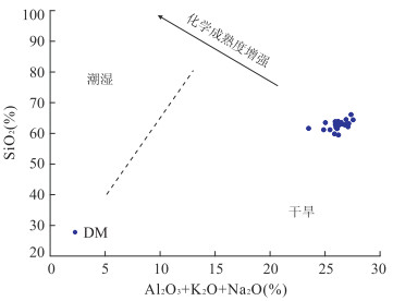
Fine mudstone can record and reflect geological aspects of source and sedimentary area. A set of lacustrine dolomite-bearing mudstones is developed in Lower Shahejie Formation of Tanggu area. To understand its tectonic setting, depositional setting, weathering and provenance, the geochemical characteristics of 25 rock samples were analyzed thoroughly. With dolomite-free modification, different indices and diagrams reveal identical geological information. Active continental margin setting (Andean-type) is revealed by the combination of high ∑REE(154.0×10⁻⁶-219.3×10⁻⁶), moderate negative Eu anomaly (0.64-0.73) and tectonic setting discriminant diagram (K2O/Na2O-SiO2, SiO2/Al2O3-K2O/Na2O, and discriminant function bivariate diagram). SiO2-(K2O+Na2O+Al2O3) bivariate discriminant diagram, equivalent B(200.17-313.21) and approximate degree of pyritization (DOPapx) (0.02~0.38), authigenic U(0.14-1.22), U/Th(0.17-0.44) indicate arid, saline and oxic depositional condition respectively. Chemical index of alteration (CIA)(51.26-65.74), plagioclase index of alteration (PIA)(51.65-78.06), modified index of composition variation (ICVm)(0.67-1.24) and A-CN-K diagram reflect mild to moderate weathering of source rock. Discriminant function diagram, K-Rb bivariate diagram, A-CN-K diagram, Al2O3/TiO2 index(23.37-28.58), REE pattern similar to upper continental crust (UCC) and negative Eu anomaly deduce the felsic rocks as the major source for the dolomite-bearing mudstones. Under such geological constrain, it is concluded that the source materials are mostly derived from Yanshan fold and thrust belt.
Fine mudstone can record and reflect geological aspects of source and sedimentary area. A set of lacustrine dolomite-bearing mudstones is developed in Lower Shahejie Formation of Tanggu area. To understand its tectonic setting, depositional setting, weathering and provenance, the geochemical characteristics of 25 rock samples were analyzed thoroughly. With dolomite-free modification, different indices and diagrams reveal identical geological information. Active continental margin setting (Andean-type) is revealed by the combination of high ∑REE(154.0×10⁻⁶-219.3×10⁻⁶), moderate negative Eu anomaly (0.64-0.73) and tectonic setting discriminant diagram (K2O/Na2O-SiO2, SiO2/Al2O3-K2O/Na2O, and discriminant function bivariate diagram). SiO2-(K2O+Na2O+Al2O3) bivariate discriminant diagram, equivalent B(200.17-313.21) and approximate degree of pyritization (DOPapx) (0.02~0.38), authigenic U(0.14-1.22), U/Th(0.17-0.44) indicate arid, saline and oxic depositional condition respectively. Chemical index of alteration (CIA)(51.26-65.74), plagioclase index of alteration (PIA)(51.65-78.06), modified index of composition variation (ICVm)(0.67-1.24) and A-CN-K diagram reflect mild to moderate weathering of source rock. Discriminant function diagram, K-Rb bivariate diagram, A-CN-K diagram, Al2O3/TiO2 index(23.37-28.58), REE pattern similar to upper continental crust (UCC) and negative Eu anomaly deduce the felsic rocks as the major source for the dolomite-bearing mudstones. Under such geological constrain, it is concluded that the source materials are mostly derived from Yanshan fold and thrust belt.


2015, 40(9): 1497-1504.
doi: 10.3799/dqkx.2015.134
Abstract:
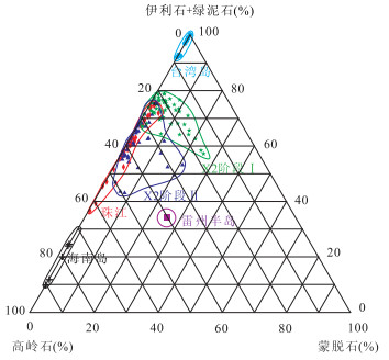
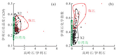
The influence of Hainan Island has been ignored in the previous researches of sediment provenance in the continental shelf of the northern South China Sea. Therefore, the sediment provenances on the basis of lithology, grain-size, AMS14C dating, clay mineral analysis that were carried out for Core X2 located in the continental shelf of the Hainan Island in the South China Sea are discussed in the paper. The results show that Core X2 is separated into two stages, namely the upper one and the lower one. The lower one(Ⅰ, 240-120 cm) is mainly composed of clay silt while the upper one (Ⅱ, 120-0 cm) consists mainly of silty sand. Clay minerals in Core X2 mainly consist of illite and kaolinite, with associated chlorite and smectite. The comparison of clay mineral assemblages between sediments at Core X2 and other potential provenances indicates that predominant illite and chlorite may have been originated from Taiwan and the Pearl River, whereas kaolinite may has been provided mainly by Hainan Island and the Pearl River; smectite was derived mainly from Leiqiong area. It shows that materials on Hainan Island have certain influence on the continental shelf in the northern South China Sea. The coarsening of the sediment and the higher content of the kaolinite mean that Hainan Island provides more materials than other provenances in stage Ⅰ, which may have been resulted from climatic variation and enhancement from human activities since 4 ka.
The influence of Hainan Island has been ignored in the previous researches of sediment provenance in the continental shelf of the northern South China Sea. Therefore, the sediment provenances on the basis of lithology, grain-size, AMS14C dating, clay mineral analysis that were carried out for Core X2 located in the continental shelf of the Hainan Island in the South China Sea are discussed in the paper. The results show that Core X2 is separated into two stages, namely the upper one and the lower one. The lower one(Ⅰ, 240-120 cm) is mainly composed of clay silt while the upper one (Ⅱ, 120-0 cm) consists mainly of silty sand. Clay minerals in Core X2 mainly consist of illite and kaolinite, with associated chlorite and smectite. The comparison of clay mineral assemblages between sediments at Core X2 and other potential provenances indicates that predominant illite and chlorite may have been originated from Taiwan and the Pearl River, whereas kaolinite may has been provided mainly by Hainan Island and the Pearl River; smectite was derived mainly from Leiqiong area. It shows that materials on Hainan Island have certain influence on the continental shelf in the northern South China Sea. The coarsening of the sediment and the higher content of the kaolinite mean that Hainan Island provides more materials than other provenances in stage Ⅰ, which may have been resulted from climatic variation and enhancement from human activities since 4 ka.


2015, 40(9): 1505-1516.
doi: 10.3799/dqkx.2015.135
Abstract:
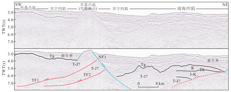
There are folds and thrust faults in Mesozoic strata in the northern continental margin of the South China Sea, however, their geneses are still in controversy. In this study, 2D seismic profiles in the southeast region of the Pearl River Mouth basin (PRMB) are interpreted. Two northeastwards thrusting faults with approximately NW-SE strike are identified in the area of Yunli lower uplift, Xingli rise and Xingning sag, and two approximately north-south striking compressional strike-slip faults are distinguished in the southern area of Dongsha uplift. The 4 faults mentioned above are about 130, 110, 55 and 58 km long, respectively. It can be concluded that the Liyue (Reed) Bank-Palawan block which lies in the southern continental margin of the SCS underwent a soft collision with South China continental margin in Middle Jurassic to Early Cretaceous, and they finally united and sutured in Late Cretaceous approximately along Liwan to Xingning sags. The afore-mentioned 4 faults may be the circumstantial evidences for the final uniting and suturing between the Liyue Bank-Palawan block and the South China continental margin in the Late Cretaceous. Because of the retreat of the Pacific subducting slab in the Late Cretaceous, the overriding South China continental margin regionally and isostatically uplifted before it began to rift in the latest Cretaceous, whereas the coeval collision between the Liyue Bank-Palawan block and the South China continental margin was localized in the southeast of the PRMB.
There are folds and thrust faults in Mesozoic strata in the northern continental margin of the South China Sea, however, their geneses are still in controversy. In this study, 2D seismic profiles in the southeast region of the Pearl River Mouth basin (PRMB) are interpreted. Two northeastwards thrusting faults with approximately NW-SE strike are identified in the area of Yunli lower uplift, Xingli rise and Xingning sag, and two approximately north-south striking compressional strike-slip faults are distinguished in the southern area of Dongsha uplift. The 4 faults mentioned above are about 130, 110, 55 and 58 km long, respectively. It can be concluded that the Liyue (Reed) Bank-Palawan block which lies in the southern continental margin of the SCS underwent a soft collision with South China continental margin in Middle Jurassic to Early Cretaceous, and they finally united and sutured in Late Cretaceous approximately along Liwan to Xingning sags. The afore-mentioned 4 faults may be the circumstantial evidences for the final uniting and suturing between the Liyue Bank-Palawan block and the South China continental margin in the Late Cretaceous. Because of the retreat of the Pacific subducting slab in the Late Cretaceous, the overriding South China continental margin regionally and isostatically uplifted before it began to rift in the latest Cretaceous, whereas the coeval collision between the Liyue Bank-Palawan block and the South China continental margin was localized in the southeast of the PRMB.


2015, 40(9): 1517-1528.
doi: 10.3799/dqkx.2015.136
Abstract:
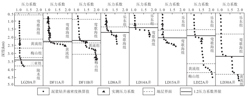
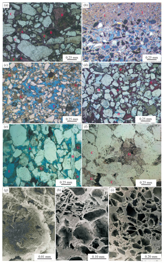
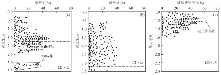
As to the Yinggehai basin, there is much room for further studies on the following issues including the distribution of abnormal pressure, the interaction of fluid and rock under the condition of abnormal pressure and the effect on diagenetic evolution. A systematic analysis on the distribution of overpressure, the effect on geological fluid activities and diagenetic evolution in Yinggehai basin is carried out by means of microscopy, scanning electron microscopy, isotope analysis and fluid inclusion homogenization temperature measurement based on the previous studies.The results show follows: (1) Overpressure drives the deep thermal fluid to release up. The thermal fluid which contains carbonate minerals is driven to the top interface of the overpressure and then deposits again with the changing pressure and temperature. The thermal fluid forms tight plugged zone of carbonate cementation with high content. (2) The overpressure reduces the material sources of carbonate cements and quartz secondary enlargement by inhibiting the transformation of clay minerals, so that the primary pores can be effectively preserved. (3) The reservoirs in LD block generally contain high content of CO2. In condition of overpressure, the solubility of CO2 in the fluid increases, which generates a large number of H+. On the other hand, overpressure increases the space and time for the release of organic acids in LD block and promotes the dissolution. It is concluded that the main reason for the high porosity in middle-deep overpressure reservoir of study area is that the overpressure constrains the forming of carbonate cement, and the other reason is that the decrease of compaction and the promotion of secondary pores.
As to the Yinggehai basin, there is much room for further studies on the following issues including the distribution of abnormal pressure, the interaction of fluid and rock under the condition of abnormal pressure and the effect on diagenetic evolution. A systematic analysis on the distribution of overpressure, the effect on geological fluid activities and diagenetic evolution in Yinggehai basin is carried out by means of microscopy, scanning electron microscopy, isotope analysis and fluid inclusion homogenization temperature measurement based on the previous studies.The results show follows: (1) Overpressure drives the deep thermal fluid to release up. The thermal fluid which contains carbonate minerals is driven to the top interface of the overpressure and then deposits again with the changing pressure and temperature. The thermal fluid forms tight plugged zone of carbonate cementation with high content. (2) The overpressure reduces the material sources of carbonate cements and quartz secondary enlargement by inhibiting the transformation of clay minerals, so that the primary pores can be effectively preserved. (3) The reservoirs in LD block generally contain high content of CO2. In condition of overpressure, the solubility of CO2 in the fluid increases, which generates a large number of H+. On the other hand, overpressure increases the space and time for the release of organic acids in LD block and promotes the dissolution. It is concluded that the main reason for the high porosity in middle-deep overpressure reservoir of study area is that the overpressure constrains the forming of carbonate cement, and the other reason is that the decrease of compaction and the promotion of secondary pores.


2015, 40(9): 1529-1537.
doi: 10.3799/dqkx.2015.137
Abstract:
There is significant relationship among deep paleo-fluid flows and modification of carbonate reservoirs and hydrocarbon migration and accumulation. In this study, 11 samples of the Ordovician in Guchengxu uplift have been employed to make diagenetic observation and fluid inclusion measurement. The analyzed results indicate that there are three events of paleo-fluid flows in the Middle and Lower Ordovician of Guchengxu uplift. (1) The first event of paleo-fluid flows is represented by the first generation of calcite cement filling in high angle and meshy fractures. It is estimated that the calcite cement precipitated during late Caledonian tectonic movement. (2) The second event of paleo-fluid flows is represented by the second generation of hydrothermal dolomites. It is estimated that the saddle dolomite precipitated during the Permian volcanic activities. (3) The third event of paleo-fluid flows is represented by the third generation of calcite cement filling in the central residual spaces of the fractures and vugs. It records the gas accumulation during the later Himalayan. The bitumen distributed along the side of first generation calcite cement implies that the early charging oil accompanied with the first event of paleo-fluid flow had been damaged. The second event of paleo-fluid flow played a role of dolomitization which was in favor of the Ordovician reservoir improvement. The third event of paleo-fluid flow is associated with natural gas filling. It is concluded that the later Himalayan charging natural gases are the favorable exploration target in this area.
There is significant relationship among deep paleo-fluid flows and modification of carbonate reservoirs and hydrocarbon migration and accumulation. In this study, 11 samples of the Ordovician in Guchengxu uplift have been employed to make diagenetic observation and fluid inclusion measurement. The analyzed results indicate that there are three events of paleo-fluid flows in the Middle and Lower Ordovician of Guchengxu uplift. (1) The first event of paleo-fluid flows is represented by the first generation of calcite cement filling in high angle and meshy fractures. It is estimated that the calcite cement precipitated during late Caledonian tectonic movement. (2) The second event of paleo-fluid flows is represented by the second generation of hydrothermal dolomites. It is estimated that the saddle dolomite precipitated during the Permian volcanic activities. (3) The third event of paleo-fluid flows is represented by the third generation of calcite cement filling in the central residual spaces of the fractures and vugs. It records the gas accumulation during the later Himalayan. The bitumen distributed along the side of first generation calcite cement implies that the early charging oil accompanied with the first event of paleo-fluid flow had been damaged. The second event of paleo-fluid flow played a role of dolomitization which was in favor of the Ordovician reservoir improvement. The third event of paleo-fluid flow is associated with natural gas filling. It is concluded that the later Himalayan charging natural gases are the favorable exploration target in this area.


2015, 40(9): 1538-1548.
doi: 10.3799/dqkx.2015.138
Abstract:
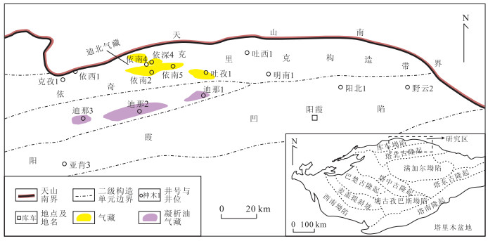
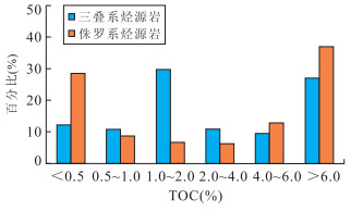
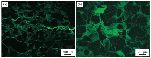
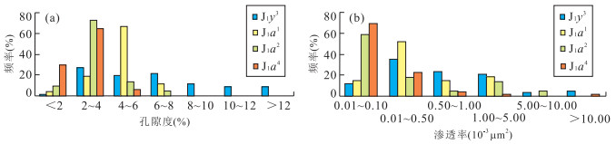
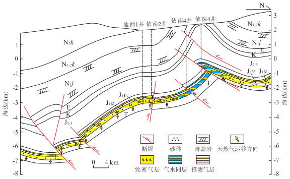
Tight sandstone gas of the Lower Jurassic is widely developed in Dibei area in the Kuqa depression. Therefore, the research of its enriched mechanism is of great significance. The data of the cores, rock slice, laser confocal scanning, displacement pressure, fluid inclusion petrological observation and microthermometric analysis are utilized to explore the enriched mechanism of the natural gas. Results show that: (1) the gas-source condition of Dibei area is superior and natural gas charged in short time; (2) fracture-pore type reservoir is widely developed and reservoir property is superior; (3) several thick mudstones and gypsum mantles cover the natural gas reservoirs and the conservation condition of the natural gas is superior; (4) composite fault-sand body pathway system is well developed and the natural gas accumulated with high-efficiency; (5) Dibei area is characterized by "early-stage accumulation of oil and late-stage accumulation of gas". The natural gas charged in the period of Kuqa age (5-0 Ma) and reservoir desificated in the period of early Kangcun period (8 Ma), which means that the period of reservoir desification was earlier than the period of bulk natural gas charging. Controlled by tectonic movement, the accumulating processes of the natural gas are separated into three phases: charged with oil at the early-middle periods of the Miocence; charged with the superposition of deep basin gas reservoir in Pliocene; charged with adjustment, modification and re-enrichment in Xiyu period. The study of enriched mechanism of the natural gas in Dibei area can facilitate the exploration for potential tight sandstone gas.
Tight sandstone gas of the Lower Jurassic is widely developed in Dibei area in the Kuqa depression. Therefore, the research of its enriched mechanism is of great significance. The data of the cores, rock slice, laser confocal scanning, displacement pressure, fluid inclusion petrological observation and microthermometric analysis are utilized to explore the enriched mechanism of the natural gas. Results show that: (1) the gas-source condition of Dibei area is superior and natural gas charged in short time; (2) fracture-pore type reservoir is widely developed and reservoir property is superior; (3) several thick mudstones and gypsum mantles cover the natural gas reservoirs and the conservation condition of the natural gas is superior; (4) composite fault-sand body pathway system is well developed and the natural gas accumulated with high-efficiency; (5) Dibei area is characterized by "early-stage accumulation of oil and late-stage accumulation of gas". The natural gas charged in the period of Kuqa age (5-0 Ma) and reservoir desificated in the period of early Kangcun period (8 Ma), which means that the period of reservoir desification was earlier than the period of bulk natural gas charging. Controlled by tectonic movement, the accumulating processes of the natural gas are separated into three phases: charged with oil at the early-middle periods of the Miocence; charged with the superposition of deep basin gas reservoir in Pliocene; charged with adjustment, modification and re-enrichment in Xiyu period. The study of enriched mechanism of the natural gas in Dibei area can facilitate the exploration for potential tight sandstone gas.


2015, 40(9): 1549-1555.
doi: 10.3799/dqkx.2015.139
Abstract:
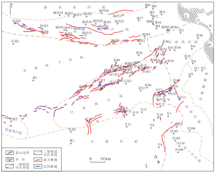
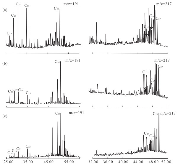
The area from Di'nan arch to Fubei slope is located in the east of the Junggar basin which includes several old apophysis and is favorable to capture hydrocarbon since there are several hydrocarbon depressions with mudstone and coals of Jurassic, which leading to complex oil-source. The contribution of the coals to the oil of Shishugou and Tugulu through the hydrocarbon generating conditions is discussed in this paper. The Jurassic coal is scattered in the area with a thickness of mere 30 m. In addition, its maceral is generally composed of inertinite. The hydrocarbon supplying ability of the coal is relatively weak compared with that of the Jurassic mudstone. Comparison of the characteristics of biomarkers from the coal-measure source rock and crude oils indicates that the contribution from Jurassic coal-measure mudstone derived oil is relatively large. It is found that the Cretaceous oil comes from the Permian mudstone and the Jurassic oil comes from both Permian and Jurassic mudstones.
The area from Di'nan arch to Fubei slope is located in the east of the Junggar basin which includes several old apophysis and is favorable to capture hydrocarbon since there are several hydrocarbon depressions with mudstone and coals of Jurassic, which leading to complex oil-source. The contribution of the coals to the oil of Shishugou and Tugulu through the hydrocarbon generating conditions is discussed in this paper. The Jurassic coal is scattered in the area with a thickness of mere 30 m. In addition, its maceral is generally composed of inertinite. The hydrocarbon supplying ability of the coal is relatively weak compared with that of the Jurassic mudstone. Comparison of the characteristics of biomarkers from the coal-measure source rock and crude oils indicates that the contribution from Jurassic coal-measure mudstone derived oil is relatively large. It is found that the Cretaceous oil comes from the Permian mudstone and the Jurassic oil comes from both Permian and Jurassic mudstones.


2015, 40(9): 1556-1565.
doi: 10.3799/dqkx.2015.140
Abstract:
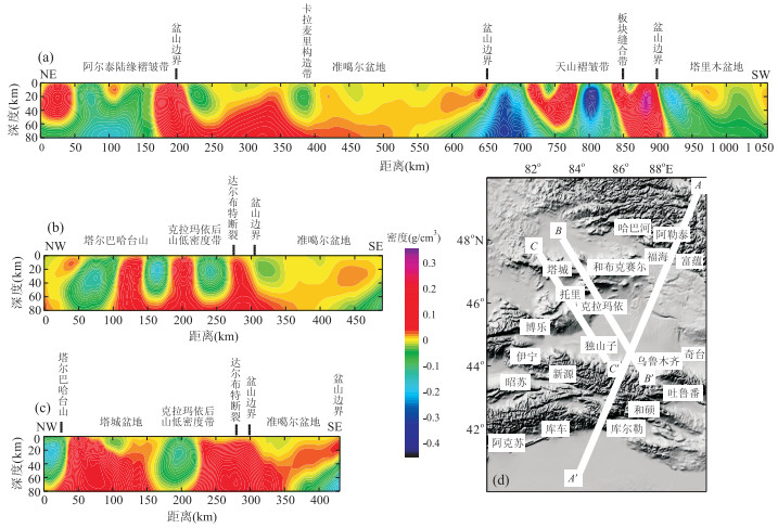
Structures in the crust and uppermost mantle beneath western Junggar and its surroundings, the key to better understanding of the tectonic evolution of the Junggar basin, are studied in this paper. Firstly, the Bouguer gravity anomaly is calculated from the satellite gravitational field model. Then 3D inversion technique is utilized, and the density imaging is operated in the crust and uppermost mantle beneath the western Junggar and its surroundings and finally the anomalous density structure at the depth range of 0-80 km is obtained. Crustal density distribution in the ancient oceanic crust of the Junggar indicates the possible subductions under the Siberian plate northeastwardly and the western Junggar northwestwardly. Density distribution in the uppermost mantle suggests that the relatively low density beneath Altay fold belt may have resulted from the thick sialic layer of the ancient continent, and Kazakhstan plate & Junggar basin are dominated by a relatively whole high-density structure while the significant density changes beneath the Tianshan fold belt describe the ultra-crustal deep faults and also the nicks of the tectonic activities and the lithospheric deformations.
Structures in the crust and uppermost mantle beneath western Junggar and its surroundings, the key to better understanding of the tectonic evolution of the Junggar basin, are studied in this paper. Firstly, the Bouguer gravity anomaly is calculated from the satellite gravitational field model. Then 3D inversion technique is utilized, and the density imaging is operated in the crust and uppermost mantle beneath the western Junggar and its surroundings and finally the anomalous density structure at the depth range of 0-80 km is obtained. Crustal density distribution in the ancient oceanic crust of the Junggar indicates the possible subductions under the Siberian plate northeastwardly and the western Junggar northwestwardly. Density distribution in the uppermost mantle suggests that the relatively low density beneath Altay fold belt may have resulted from the thick sialic layer of the ancient continent, and Kazakhstan plate & Junggar basin are dominated by a relatively whole high-density structure while the significant density changes beneath the Tianshan fold belt describe the ultra-crustal deep faults and also the nicks of the tectonic activities and the lithospheric deformations.


2015, 40(9): 1566-1575.
doi: 10.3799/dqkx.2015.141
Abstract:
In order to investigate the material migration of crust and mantle after the formation of large impact basins, a study on the undulation of crust-mantle interface, using new lunar gravity data is carried out. This has an important significance for the research of the formation and evolution of impact basin. The forward modeling of the gravity anomaly established by filling mare basalts in Sinus Iridum-Mare Imbrium basin area shows that the gravity anomaly only accounts for about 8% in the amplitude of total Bouguer gravity anomaly, while the rest 92% is mainly related to the perturbation of crust-mantle interface. The edge detection of the Bouguer gravity anomaly at different observing heights in Sinus Iridum-Mare Imbrium area indicates that the crust-mantle interface beneath the area of Sinus Iridum-Mare Imbrium northwest leans to the center of Mare Imbrium with increasing depth. It is concluded that extra mantle uplifts to Sinus Iridum area in the crust-mantle interface may have been caused by the impact forming Mare Imbrium basin. This or the later Sinus Iridum impact may have induced a second effect on the crust-mantle structure beneath Mare Imbrium basin. During the lunar mantle rebounds, there may have been a force dragging the mantle beneath the Mare Imbrium toward the Sinus Iridum area.
In order to investigate the material migration of crust and mantle after the formation of large impact basins, a study on the undulation of crust-mantle interface, using new lunar gravity data is carried out. This has an important significance for the research of the formation and evolution of impact basin. The forward modeling of the gravity anomaly established by filling mare basalts in Sinus Iridum-Mare Imbrium basin area shows that the gravity anomaly only accounts for about 8% in the amplitude of total Bouguer gravity anomaly, while the rest 92% is mainly related to the perturbation of crust-mantle interface. The edge detection of the Bouguer gravity anomaly at different observing heights in Sinus Iridum-Mare Imbrium area indicates that the crust-mantle interface beneath the area of Sinus Iridum-Mare Imbrium northwest leans to the center of Mare Imbrium with increasing depth. It is concluded that extra mantle uplifts to Sinus Iridum area in the crust-mantle interface may have been caused by the impact forming Mare Imbrium basin. This or the later Sinus Iridum impact may have induced a second effect on the crust-mantle structure beneath Mare Imbrium basin. During the lunar mantle rebounds, there may have been a force dragging the mantle beneath the Mare Imbrium toward the Sinus Iridum area.


2015, 40(9): 1576-1584.
doi: 10.3799/dqkx.2015.142
Abstract:
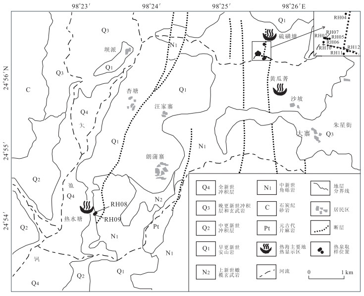
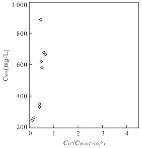
High temperature geothermal system contains plenty of geothermal resources. In order to further understand the high temperature geothermal system, taking the Rehai geothermal field of Tengchong as a typical study area and the geochemical compositions of Rehai hot springs as basic data, the temperature of parent geothermal fluid (PGF) below Rehai is estimated by use of multiple geochemical models, based on which the cooling processes of PGF during its ascent to surface are analyzed as well. The geothermal waters discharged from both Liuhuangtang and Reshuitang of Rehai originate from the same deep reservoir where a parent geothermal fluid with Cl- concentration of 265 mg/L and temperature of 336 ℃ was identified. The Dagunguo spring with the highest vent temperature at Rehai was formed via direct adiabatic cooling of PGF, whereas the other neutral springs are primarily the results of mixing between PGF and shallow cold groundwater, although boiling was also involved after the mixing. Above the deep reservoir containing PGF, there exist many geothermal reservoirs with temperatures higher than 200 ℃. The formation of these reservoirs is possibly controlled by the faults with different stretching directions at Rehai.
High temperature geothermal system contains plenty of geothermal resources. In order to further understand the high temperature geothermal system, taking the Rehai geothermal field of Tengchong as a typical study area and the geochemical compositions of Rehai hot springs as basic data, the temperature of parent geothermal fluid (PGF) below Rehai is estimated by use of multiple geochemical models, based on which the cooling processes of PGF during its ascent to surface are analyzed as well. The geothermal waters discharged from both Liuhuangtang and Reshuitang of Rehai originate from the same deep reservoir where a parent geothermal fluid with Cl- concentration of 265 mg/L and temperature of 336 ℃ was identified. The Dagunguo spring with the highest vent temperature at Rehai was formed via direct adiabatic cooling of PGF, whereas the other neutral springs are primarily the results of mixing between PGF and shallow cold groundwater, although boiling was also involved after the mixing. Above the deep reservoir containing PGF, there exist many geothermal reservoirs with temperatures higher than 200 ℃. The formation of these reservoirs is possibly controlled by the faults with different stretching directions at Rehai.


2015, 40(9): 1585-1597.
doi: 10.3799/dqkx.2015.143
Abstract:
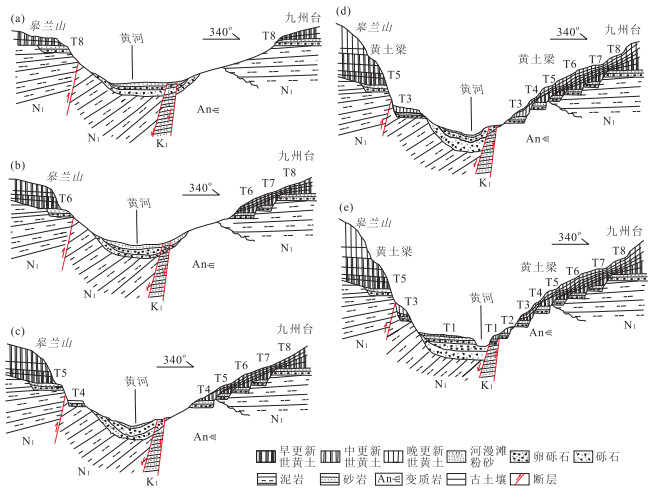
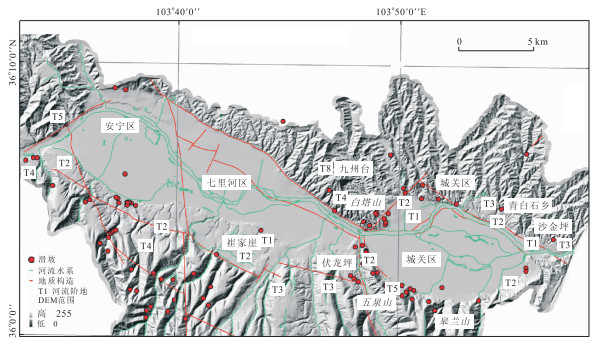
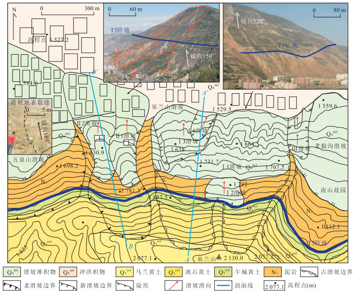
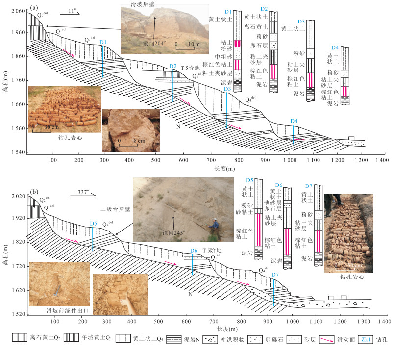
In order to explore the relationship between the geological settings and the development of the slides, and mechanisms of landslides induced by evolution of the Yellow River terrace in Lanzhou, the development phase characters of the Yellow River valley evolution in Lanzhou, control effect of the valley evolution to landslides and landslide formation model are studied in this paper based on extensive analysis of regional engineering geology data, combined with Quaternary geomorphology and engineering geology. It is found that: (1) the control effect of landslides in Lanzhou induced by the Yellow River valley evolution shows phase in time and zonation in space. The landslides have different development modes and formation mechanisms in different phases of river valley evolution. (2) The major inducing factors of terrace landslides are intense neotectonics uplifting, strong incision of the Yellow River and relative moisture paleoclimate during the terraces formed. The weak intercalated layers formed in Tertiary mudstone stratum may induce large scale loess-mudstone landslides while it may develop small-middle scale landslides and collapses in the loess layer. The landslides may lead to the deficiency of partial terraces during the river valley evolution.
In order to explore the relationship between the geological settings and the development of the slides, and mechanisms of landslides induced by evolution of the Yellow River terrace in Lanzhou, the development phase characters of the Yellow River valley evolution in Lanzhou, control effect of the valley evolution to landslides and landslide formation model are studied in this paper based on extensive analysis of regional engineering geology data, combined with Quaternary geomorphology and engineering geology. It is found that: (1) the control effect of landslides in Lanzhou induced by the Yellow River valley evolution shows phase in time and zonation in space. The landslides have different development modes and formation mechanisms in different phases of river valley evolution. (2) The major inducing factors of terrace landslides are intense neotectonics uplifting, strong incision of the Yellow River and relative moisture paleoclimate during the terraces formed. The weak intercalated layers formed in Tertiary mudstone stratum may induce large scale loess-mudstone landslides while it may develop small-middle scale landslides and collapses in the loess layer. The landslides may lead to the deficiency of partial terraces during the river valley evolution.


2015, 40(9): 1598-1606.
doi: 10.3799/dqkx.2015.144
Abstract:
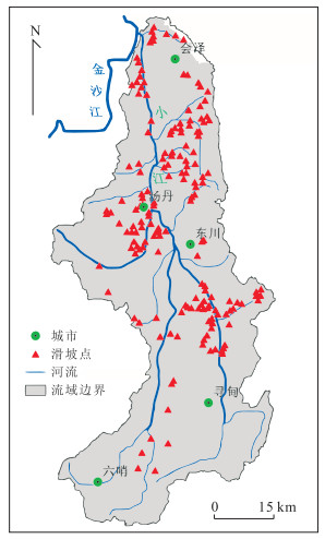
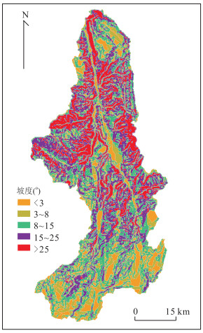
It's a top priority to estimate risk of landslides for landslide disaster prevention and disaster reduction. In this paper, taking Xiaojiang ravine, a frequent debris flow occurring area as the study area, a classification assessment system of landslide risk is built by selecting 3 evaluation indexes including slope, cohesive force and internal friction angle based on the geographic information system support. Moreover, the projection pursuit technique is applied to evaluate landslide risk classification. According to linear projection of index factors of evaluation samples, the projection pursuit model to classification evaluation of landslide risk is built and the classification map of landslide risk zoning is drawn by the optimal projection direction of the projection characteristic value. The results show that the area ratio of extremely high risk zone, high risk zone, medium risk zone, low risk zone, extremely low risk zone in the study area is 14.28∶9.41∶69.12∶7.00∶0.19. A total of 60 landslides were verified in the study area according to the established evaluation index system of level 5. The high and extremly high risk zones cover 23.69% of the study area, but the actual number of soil landslides is 45, and the number of soil landslides in those risk zones is 75.00% of the total. The number of soil landslides in medium risk level and above risk zones is 96.67% of the total. The statistical results of landslide risk point density in the classification map of landslide risk zoning show that the density of landslides' volume increases rapidly with the increase of risk level. The evaluation results are relatively more consistent with actual situation and more reasonable compared with the measured results. The model proves to be a new perspective for landslide risk prediction.
It's a top priority to estimate risk of landslides for landslide disaster prevention and disaster reduction. In this paper, taking Xiaojiang ravine, a frequent debris flow occurring area as the study area, a classification assessment system of landslide risk is built by selecting 3 evaluation indexes including slope, cohesive force and internal friction angle based on the geographic information system support. Moreover, the projection pursuit technique is applied to evaluate landslide risk classification. According to linear projection of index factors of evaluation samples, the projection pursuit model to classification evaluation of landslide risk is built and the classification map of landslide risk zoning is drawn by the optimal projection direction of the projection characteristic value. The results show that the area ratio of extremely high risk zone, high risk zone, medium risk zone, low risk zone, extremely low risk zone in the study area is 14.28∶9.41∶69.12∶7.00∶0.19. A total of 60 landslides were verified in the study area according to the established evaluation index system of level 5. The high and extremly high risk zones cover 23.69% of the study area, but the actual number of soil landslides is 45, and the number of soil landslides in those risk zones is 75.00% of the total. The number of soil landslides in medium risk level and above risk zones is 96.67% of the total. The statistical results of landslide risk point density in the classification map of landslide risk zoning show that the density of landslides' volume increases rapidly with the increase of risk level. The evaluation results are relatively more consistent with actual situation and more reasonable compared with the measured results. The model proves to be a new perspective for landslide risk prediction.