2016 Vol. 41, No. 10
Display Method:
 PDF 1452KB
2016, 41(10): 1619-1629.
doi: 10.3799/dqkx.2016.120
Abstract:
The resource of gas hydrate in South China Sea is plentiful. It redound to resource development by investigating how the gas hydrate decompose. A sedimentology and geochemistry study has been done in gas-hydrate-bearing borehole sediment collected at site GMGS08 within the gas hydrate drilling area in the northeastern South China Sea. Results show that 11 layers of authigenic carbonate and bivalve bioclast, and 2 layers of carbonate limestone are distributed from top to bottom in hole GMGS08. Authigenic carbonate and bivalve bioclast primarily occurred in soupy structure sediments with high water content. The δ13C values of authigenic carbonate ranged from -41.36×10⁻³ to -56.74×10⁻³ except one sample with a higher δ13C value of -38.85×10⁻³, and the δ18O values were apparently heavy ranging from 2.94×10⁻³ to 5.37×10⁻³, suggesting they were attributed to gas hydrate dissociation via microbial anaerobic oxidation of methane, which was predominantly biogenic gas. The δ13C values of organic carbon varied from -21.33×10⁻³ to -82.44×10⁻³, in which the δ13C negative excursion intervals corresponded to authigenic carbonate layers. According to the distribution of authigenic carbonate, it is concluded that at least 6 episodes of gas hydrate release existed in geologic record, and the varying sizes of authigenic carbonate among the layers indicated the intensity of methane flux in each episode was different.
The resource of gas hydrate in South China Sea is plentiful. It redound to resource development by investigating how the gas hydrate decompose. A sedimentology and geochemistry study has been done in gas-hydrate-bearing borehole sediment collected at site GMGS08 within the gas hydrate drilling area in the northeastern South China Sea. Results show that 11 layers of authigenic carbonate and bivalve bioclast, and 2 layers of carbonate limestone are distributed from top to bottom in hole GMGS08. Authigenic carbonate and bivalve bioclast primarily occurred in soupy structure sediments with high water content. The δ13C values of authigenic carbonate ranged from -41.36×10⁻³ to -56.74×10⁻³ except one sample with a higher δ13C value of -38.85×10⁻³, and the δ18O values were apparently heavy ranging from 2.94×10⁻³ to 5.37×10⁻³, suggesting they were attributed to gas hydrate dissociation via microbial anaerobic oxidation of methane, which was predominantly biogenic gas. The δ13C values of organic carbon varied from -21.33×10⁻³ to -82.44×10⁻³, in which the δ13C negative excursion intervals corresponded to authigenic carbonate layers. According to the distribution of authigenic carbonate, it is concluded that at least 6 episodes of gas hydrate release existed in geologic record, and the varying sizes of authigenic carbonate among the layers indicated the intensity of methane flux in each episode was different.


2016, 41(10): 1630-1654.
doi: 10.3799/dqkx.2016.121
Abstract:
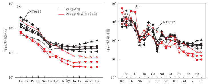
Neoproterozoic sedimentary sequences from the Yangtze block are completely developed and widely distributed. The Nantuo tillites in the Three Gorge area are glacial diamictites from the northern Yangtze block in the Nanhua period, which unconformably overlie the Neoproterozoic Huangling granites. The compositions of the Nantuo tillites are complicated, and the sedimentary time and components of source are rarely studied and remain in dispute. Zircon U-Pb dating results of the Nantuo tillite in this study yield youngest zircon age of 706±7 Ma. Combining with previous results about zircon U-Pb ages of the tuff from basal Doushantuo Formation and top of Datangpo Formation, the sedimentary ages of the Nantuo Formation are limited to 654-635 Ma, which can be equal to that of Marinoan. The peaks of zircon U-Pb age-spectrum are ~3.0 Ga, 2.5-2.3 Ga, 2.05-1.95 Ga and 900-700 Ma respectively, which indicate four crustal-reworking events in the Yangtze block. The ages of Paleoproterozoic and Archean are similar to that of the Kongling complex, meanwhile, 900-800 Ma and 800-700 Ma are the same as that of the Huangling granites nearby and the rocks from northern margin of the Yangtze block. The trace elements and isotope compositions of moraine sandstones show obvious differentiation, maybe due to the different degrees of mixture by materials from the northern margin of the Yangtze block, the Huangling granite and the Kongling Complex. Granitic conglomerates in the Nantuo tillites have different features of trace elements, low REE contents and depleted HREE. Associated with zircon U-Pb age and signature of Sr-Nd isotopes, these granitic conglomerates probably mainly came from the Huangling batholith and the Kongling Complex. The provenance characteristics of the Nantuo tillites reflect intensive rift related magma activities in the Yangtze block during the Neoproterozoic time, which causes the terrain featuring "lower in the south and higher in the north".
Neoproterozoic sedimentary sequences from the Yangtze block are completely developed and widely distributed. The Nantuo tillites in the Three Gorge area are glacial diamictites from the northern Yangtze block in the Nanhua period, which unconformably overlie the Neoproterozoic Huangling granites. The compositions of the Nantuo tillites are complicated, and the sedimentary time and components of source are rarely studied and remain in dispute. Zircon U-Pb dating results of the Nantuo tillite in this study yield youngest zircon age of 706±7 Ma. Combining with previous results about zircon U-Pb ages of the tuff from basal Doushantuo Formation and top of Datangpo Formation, the sedimentary ages of the Nantuo Formation are limited to 654-635 Ma, which can be equal to that of Marinoan. The peaks of zircon U-Pb age-spectrum are ~3.0 Ga, 2.5-2.3 Ga, 2.05-1.95 Ga and 900-700 Ma respectively, which indicate four crustal-reworking events in the Yangtze block. The ages of Paleoproterozoic and Archean are similar to that of the Kongling complex, meanwhile, 900-800 Ma and 800-700 Ma are the same as that of the Huangling granites nearby and the rocks from northern margin of the Yangtze block. The trace elements and isotope compositions of moraine sandstones show obvious differentiation, maybe due to the different degrees of mixture by materials from the northern margin of the Yangtze block, the Huangling granite and the Kongling Complex. Granitic conglomerates in the Nantuo tillites have different features of trace elements, low REE contents and depleted HREE. Associated with zircon U-Pb age and signature of Sr-Nd isotopes, these granitic conglomerates probably mainly came from the Huangling batholith and the Kongling Complex. The provenance characteristics of the Nantuo tillites reflect intensive rift related magma activities in the Yangtze block during the Neoproterozoic time, which causes the terrain featuring "lower in the south and higher in the north".


2016, 41(10): 1655-1664.
doi: 10.3799/dqkx.2016.524
Abstract:
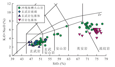
The Okinawa Trough is a young back-arc basin at its early back-arc spreading stage, and is a natural laboratory for understanding the formation and evolution of back-arc basins and crust-mantle interaction processes under this tectonic setting. However, with the gradually deepening of research work, the rock series of volcanic rocks from the Okinawa Trough are becoming an important and urgent need to solve problem. Based on the geochemical compositions of some pumices determined recently by authors and the petrologic and geochemical data of volcanic lavas from the Okinawa Trough in literatures, the rock series of volcanic rocks from the Okinawa Trough have been determined in detail. The tectonic significance of volcanic rocks and the genesis relationship between pumices and basalts have also been discussed. The magmatism in the Okinawa Trough is bimodal, being comprised dominantly of basic basalts and acidic rhyolites, accompanied by minor intermediate rocks. The basalts are mainly olivine tholeiitic basalts, which belong to subalkalic series, and the pumices are mostly rhyodacite or rhyolite, which belong to subalkalic series too. According to the geochemical compositions, basalts are not only similar to those from the mid-ocean ridge but also from the island arc tectonic environment. They are different from those occurring at mid-ocean ridge spreading center or mature back-arc basins, but with distinct geochemical features associated with distinct tectonic environment their occurred, a back-arc basin at early spreading stage. The acid pumice, a widely distributed rock type in Okinawa Trough, is characterized by the geochemical compositions that are typical for volcanic rocks from island arcs. The magma of intermediate-acidic pumices, with same sources as associated basalts, may be formed by fractional crystallization of basalt magma.
The Okinawa Trough is a young back-arc basin at its early back-arc spreading stage, and is a natural laboratory for understanding the formation and evolution of back-arc basins and crust-mantle interaction processes under this tectonic setting. However, with the gradually deepening of research work, the rock series of volcanic rocks from the Okinawa Trough are becoming an important and urgent need to solve problem. Based on the geochemical compositions of some pumices determined recently by authors and the petrologic and geochemical data of volcanic lavas from the Okinawa Trough in literatures, the rock series of volcanic rocks from the Okinawa Trough have been determined in detail. The tectonic significance of volcanic rocks and the genesis relationship between pumices and basalts have also been discussed. The magmatism in the Okinawa Trough is bimodal, being comprised dominantly of basic basalts and acidic rhyolites, accompanied by minor intermediate rocks. The basalts are mainly olivine tholeiitic basalts, which belong to subalkalic series, and the pumices are mostly rhyodacite or rhyolite, which belong to subalkalic series too. According to the geochemical compositions, basalts are not only similar to those from the mid-ocean ridge but also from the island arc tectonic environment. They are different from those occurring at mid-ocean ridge spreading center or mature back-arc basins, but with distinct geochemical features associated with distinct tectonic environment their occurred, a back-arc basin at early spreading stage. The acid pumice, a widely distributed rock type in Okinawa Trough, is characterized by the geochemical compositions that are typical for volcanic rocks from island arcs. The magma of intermediate-acidic pumices, with same sources as associated basalts, may be formed by fractional crystallization of basalt magma.


2016, 41(10): 1665-1682.
doi: 10.3799/dqkx.2016.122
Abstract:
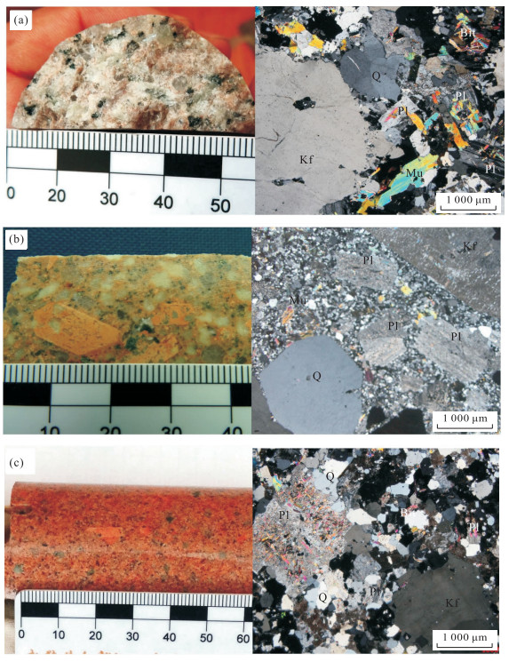
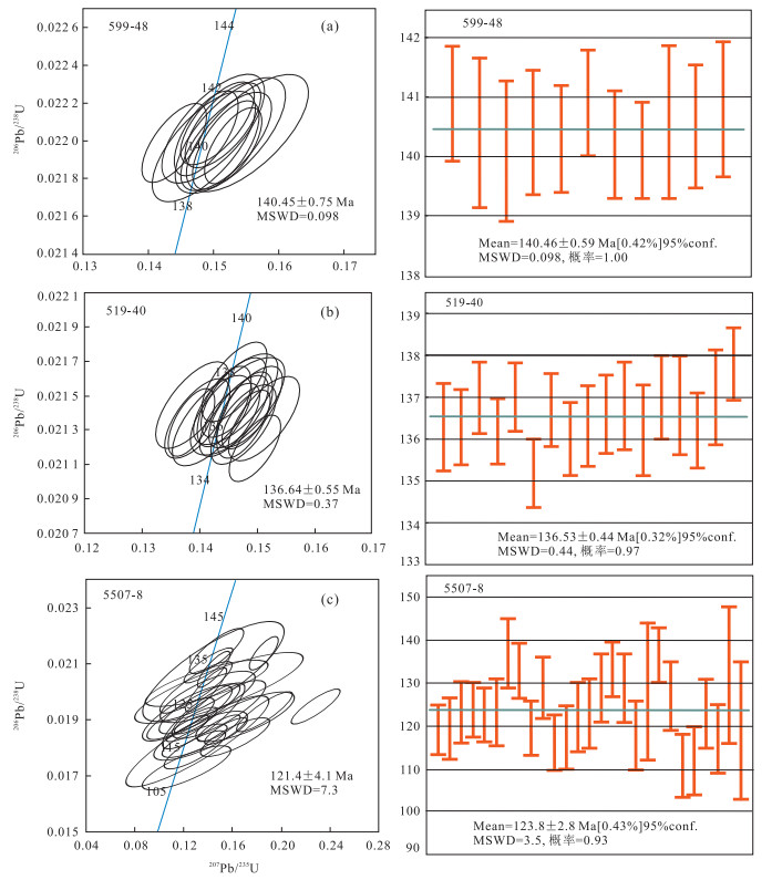
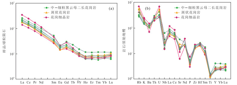
The Shiyaogou granite is a related to the molybdenum mineralization hidden granite, which is found for the first time in the Xionger Mountain at the East Qinling, southern margin of North China landmass. The lithology of the granite is mainly medium-fine biotite monzogranite and porphyritic granite, and the LA-ICP-MS zircon U-Pb dating results indicate that it was formed in the early Cretaceous(140.45±0.75 Ma-136.64±0.55 Ma). The geochemical data show that the granite is characterized by SiO2(70.27%-73.22%), Al2O3(12.71%-14.96%), MgO(0.23%-0.54%), the total alkaline(K2O+Na2O) ranging from 6.43% to 11.78wt%, which suggests that the granite has high silicon and rich alkali characteristics. The Rittmann Index (δ) ranges from 2.11 to 3.02, and AR ranges from 1.48 to 5.73, which shows the granite is calc-alkaline series. The A/CNK value is 0.95-1.01, and shows a Aluminum-peraluminous Ⅰ-type granite characteristic. The ∑REE of the granite ranges form 147×10-6 to 322×10-6, the ratio of LREE/HREE ranges from 15.2 to 25.2, and the value of LaN/YbN ranges from 19.10×10⁻⁶ to 50.50×10⁻⁶. The chonrite standardized distribution pattern is characterized by enrichment of LREE in the right-dipping type with medium-weak negative Eu anomalies(δEu=0.53-0.71, average 0.62). The trace elements are characterized by the value of Sr(133×10-6-759×10-6, average 371×10-6), the low value of Y and Yb(Y=10.02×10⁻⁶-18.80×10⁻⁶, average 12.57×10⁻⁶; Yb=1.16×10⁻⁶-2.02×10⁻⁶, average 1.40×10⁻⁶), and the lower ratio of Sr/Y(12.77-61.66, average 30.44). The geochemical characteristics reflect the granite melt experienced feldspar fractional crystallization in the magma. The initial isotopic Sr ratio(Isr=0.707 44-0.713 84), the initial epsilon Sr(εSr(t)= 44.1-134.9) and Nd(εNd(t)=-12.96 to -13.46) disclose the Shiyaogou hidden granite has a magma homology with the Mesozoic Heyu granite. The Nd model ages(tDM2) of the granites are concentrated in 2.00-2.01 Ga. All the isotopic data suggest the granite formed by the melting of the South Qinling and Yangtze block crystalline basement and with participation of Taihua and Xionger groups. The regional geology and geochemical characteristics suggest that the formtion of the Shiyaogou granite experienced two stages: Before Jurassic, the crust of East Qinling thickened with the subduction-collision of South Qinling and Yangtze Block under the North China block; In the Jurassic and Cretaceous, when the extrusion environment changed to the extension condition, with the decompression and warming, partial melting of the middle-lower continental crust, finally formed the Shiyaogou granite in the Early Cretaceous.
The Shiyaogou granite is a related to the molybdenum mineralization hidden granite, which is found for the first time in the Xionger Mountain at the East Qinling, southern margin of North China landmass. The lithology of the granite is mainly medium-fine biotite monzogranite and porphyritic granite, and the LA-ICP-MS zircon U-Pb dating results indicate that it was formed in the early Cretaceous(140.45±0.75 Ma-136.64±0.55 Ma). The geochemical data show that the granite is characterized by SiO2(70.27%-73.22%), Al2O3(12.71%-14.96%), MgO(0.23%-0.54%), the total alkaline(K2O+Na2O) ranging from 6.43% to 11.78wt%, which suggests that the granite has high silicon and rich alkali characteristics. The Rittmann Index (δ) ranges from 2.11 to 3.02, and AR ranges from 1.48 to 5.73, which shows the granite is calc-alkaline series. The A/CNK value is 0.95-1.01, and shows a Aluminum-peraluminous Ⅰ-type granite characteristic. The ∑REE of the granite ranges form 147×10-6 to 322×10-6, the ratio of LREE/HREE ranges from 15.2 to 25.2, and the value of LaN/YbN ranges from 19.10×10⁻⁶ to 50.50×10⁻⁶. The chonrite standardized distribution pattern is characterized by enrichment of LREE in the right-dipping type with medium-weak negative Eu anomalies(δEu=0.53-0.71, average 0.62). The trace elements are characterized by the value of Sr(133×10-6-759×10-6, average 371×10-6), the low value of Y and Yb(Y=10.02×10⁻⁶-18.80×10⁻⁶, average 12.57×10⁻⁶; Yb=1.16×10⁻⁶-2.02×10⁻⁶, average 1.40×10⁻⁶), and the lower ratio of Sr/Y(12.77-61.66, average 30.44). The geochemical characteristics reflect the granite melt experienced feldspar fractional crystallization in the magma. The initial isotopic Sr ratio(Isr=0.707 44-0.713 84), the initial epsilon Sr(εSr(t)= 44.1-134.9) and Nd(εNd(t)=-12.96 to -13.46) disclose the Shiyaogou hidden granite has a magma homology with the Mesozoic Heyu granite. The Nd model ages(tDM2) of the granites are concentrated in 2.00-2.01 Ga. All the isotopic data suggest the granite formed by the melting of the South Qinling and Yangtze block crystalline basement and with participation of Taihua and Xionger groups. The regional geology and geochemical characteristics suggest that the formtion of the Shiyaogou granite experienced two stages: Before Jurassic, the crust of East Qinling thickened with the subduction-collision of South Qinling and Yangtze Block under the North China block; In the Jurassic and Cretaceous, when the extrusion environment changed to the extension condition, with the decompression and warming, partial melting of the middle-lower continental crust, finally formed the Shiyaogou granite in the Early Cretaceous.


2016, 41(10): 1683-1695.
doi: 10.3799/dqkx.2016.506
Abstract:
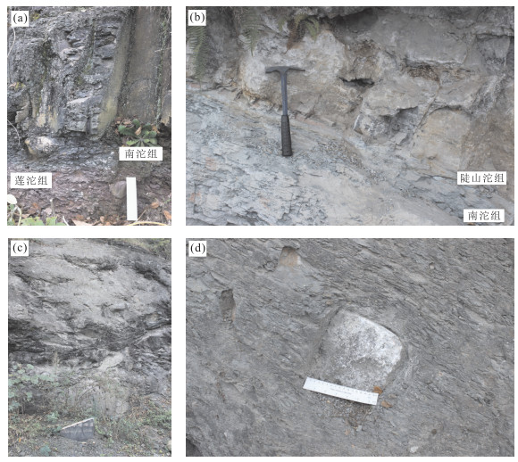
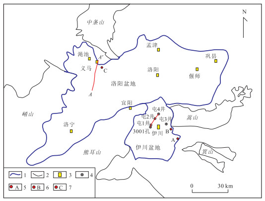
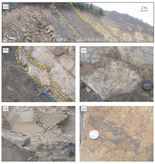
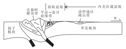
By using the data of core, well logging and outcrop, the sedimentary characteristics and evolution law of Triassic system, Luoyi District are studied. It is found that there are three sedimentary facies including meandering river, delta and lacustrine developed in Triassic period. The middle and lower Triassic system mainly developed meandering river, while the upper Triassic system developed delta and lacustrine sedimentary facies along with the expansion of the lake area and the rising of the lake surface. The evolution law of sedimentary system is controlled by the Indosinian movement during middle Triassic. This movement caused the Yangtze plate to subduct to the North China plate, uplifted the surrounding of Luoyi District and made the sedimentary of deep-water lake in Luoyi District. By contrasting the sedimentary characteristics and stratigraphic trap of Luoyi District with those of Ordos basin, the exploration potential of Luoyi District is proved. The study of the sedimentary characteristics and evolution of Luoyi District provides more favorable geological evidences for the future exploration in the region.
By using the data of core, well logging and outcrop, the sedimentary characteristics and evolution law of Triassic system, Luoyi District are studied. It is found that there are three sedimentary facies including meandering river, delta and lacustrine developed in Triassic period. The middle and lower Triassic system mainly developed meandering river, while the upper Triassic system developed delta and lacustrine sedimentary facies along with the expansion of the lake area and the rising of the lake surface. The evolution law of sedimentary system is controlled by the Indosinian movement during middle Triassic. This movement caused the Yangtze plate to subduct to the North China plate, uplifted the surrounding of Luoyi District and made the sedimentary of deep-water lake in Luoyi District. By contrasting the sedimentary characteristics and stratigraphic trap of Luoyi District with those of Ordos basin, the exploration potential of Luoyi District is proved. The study of the sedimentary characteristics and evolution of Luoyi District provides more favorable geological evidences for the future exploration in the region.


2016, 41(10): 1696-1708.
doi: 10.3799/dqkx.2016.501
Abstract:
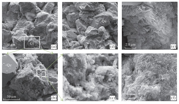
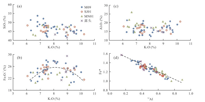
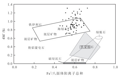
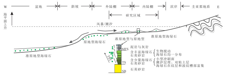
Glauconitic sandstones in Napo UT Member of Cretaceous developed widely in the Oriente Basin, Ecuador. Petrographic, mineralogical, geochemical, and spatial and temporal investigations of glauconite can reveal its composition, maturity, formation and genetic types, which, together with geological constraints, can better the understanding of the significance of sedimentary geology. Using the microscopy, X-ray diffraction (XRD), electron probe microanalyzer (EPMA) and Qemscan, petrography, mineral composition and major elements were analyzed systematically. Glauconite in UT Member shows dark green and curved rosette-like nanostructure and has high K2O content (8 wt%), indicating it evolved to highly evolved and formed at low sedimentation rate in marine environment. Chemical composition and spatial and temporal attributes of glauconite reveal its characteristics of intrasequential (parautochthonous) glaucony, and indicate as well that it has undergone transport of storm surges and/or tidal currents processes. All evidences, including upward increasement of glauconite content, maturity variation, and similarity of morphology and chemical composition between samples from the outcrop and within the basin, indicate characteristics of parautochthonous glaucony. Upward increasement of glauconite content also suggests that the parautochthonous glauconite formed in the outer shelf shifted landward, indicating the relative sea-level rise during the marine transgressive setting. Widespread distribution of contemporaneous/para-contemporaneous glauconites usually represents the epeiric sea environment with stable tectonic setting.
Glauconitic sandstones in Napo UT Member of Cretaceous developed widely in the Oriente Basin, Ecuador. Petrographic, mineralogical, geochemical, and spatial and temporal investigations of glauconite can reveal its composition, maturity, formation and genetic types, which, together with geological constraints, can better the understanding of the significance of sedimentary geology. Using the microscopy, X-ray diffraction (XRD), electron probe microanalyzer (EPMA) and Qemscan, petrography, mineral composition and major elements were analyzed systematically. Glauconite in UT Member shows dark green and curved rosette-like nanostructure and has high K2O content (8 wt%), indicating it evolved to highly evolved and formed at low sedimentation rate in marine environment. Chemical composition and spatial and temporal attributes of glauconite reveal its characteristics of intrasequential (parautochthonous) glaucony, and indicate as well that it has undergone transport of storm surges and/or tidal currents processes. All evidences, including upward increasement of glauconite content, maturity variation, and similarity of morphology and chemical composition between samples from the outcrop and within the basin, indicate characteristics of parautochthonous glaucony. Upward increasement of glauconite content also suggests that the parautochthonous glauconite formed in the outer shelf shifted landward, indicating the relative sea-level rise during the marine transgressive setting. Widespread distribution of contemporaneous/para-contemporaneous glauconites usually represents the epeiric sea environment with stable tectonic setting.


2016, 41(10): 1709-1722.
doi: 10.3799/dqkx.2016.123
Abstract:
The Permian-Triassic extinction event, which was associated with major global environmental changes, was the most significant one in the Phanerozoic. However, fossil records around the Permian-Triassic boundary in the terrestrial section are not complete compared with those in the marine section, and the precise time framework is not available. Thus the study of the Permian-Triassic boundary in terrestrial section has been hot and complicated. The Jinzhong section located in the eastern margin of the Kangdian Continent, near the transitional facies zone of the Permian and Triassic, can be compared with the marine section and terrestrial section at the same time in this period. The Jinzhong section has abundant fossils, including bivalve (4 genus 6 species), conchostracans (2 genus 4 species), plant fossils (9 genus) and brachiopods (1 genus).According to the age of the conchostracans fossil assemblages Euestheria gutta-Palaeolimnadia xuanweiensis, the plant fossil assemblages Annalepis sp.-Peltaspermum sp. and the bivalve fossil assemblages Pteria ussurica variabilis-Neoschizodus orbicularis, the Permian-Triassic boundary in the Jinzhong section is at the bottom of Kayitou Formation. In addition, the conchostracans fossil assemblages Euestheria gutta-Palaeolimnadia xuanweiensis and the bivalve fossil assemblages Pteria ussurica variabilis-Neoschizodus orbicularis can be used as a reliable marker of early Triassic in stratigraphic division and correlation in the marine-continental transitional facies in South China.
The Permian-Triassic extinction event, which was associated with major global environmental changes, was the most significant one in the Phanerozoic. However, fossil records around the Permian-Triassic boundary in the terrestrial section are not complete compared with those in the marine section, and the precise time framework is not available. Thus the study of the Permian-Triassic boundary in terrestrial section has been hot and complicated. The Jinzhong section located in the eastern margin of the Kangdian Continent, near the transitional facies zone of the Permian and Triassic, can be compared with the marine section and terrestrial section at the same time in this period. The Jinzhong section has abundant fossils, including bivalve (4 genus 6 species), conchostracans (2 genus 4 species), plant fossils (9 genus) and brachiopods (1 genus).According to the age of the conchostracans fossil assemblages Euestheria gutta-Palaeolimnadia xuanweiensis, the plant fossil assemblages Annalepis sp.-Peltaspermum sp. and the bivalve fossil assemblages Pteria ussurica variabilis-Neoschizodus orbicularis, the Permian-Triassic boundary in the Jinzhong section is at the bottom of Kayitou Formation. In addition, the conchostracans fossil assemblages Euestheria gutta-Palaeolimnadia xuanweiensis and the bivalve fossil assemblages Pteria ussurica variabilis-Neoschizodus orbicularis can be used as a reliable marker of early Triassic in stratigraphic division and correlation in the marine-continental transitional facies in South China.


2016, 41(10): 1723-1734.
doi: 10.3799/dqkx.2016.509
Abstract:
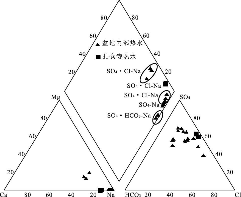
In order to further study the occurrence state and origin of geothermal resources in Guide basin, the hydrochemistry, hydrogen and oxygen isotope data from the study area are collected to analyze the geochemical properties and evolution of geothermal water and to calculate the geothermal reservoir temperature of high-temperature field. Hydrochemistry analysis of geothermal fluids show that the high-temperature thermal water is mainly of SO4·Cl-Na type, and the low-temperature thermal water is mainly of SO4-Na、SO4·HCO3-Na. There is a positive correlation between Li, F, Sr, As and Cl in Zhacangsi thermal field, which indicates the possible same origin, and the positive correlation between SiO2 and Cl confirms the deep hot source of geothermal resources. The δD values range from-59‰ to-87‰, the δ18O values range from-8.6‰ to 12.2‰, and they are all distributed near the local meteoric water line, which suggests the thermal water in study area is recharged from the atmospheric precipitation mainly. The temperature and depths of geothermal reservoir of Zhacangsi thermal field are calculated using reasonable geothermometers. The Na-K-Mg equilibrium diagram reflects that the cold water mixing action occurred in Zhacangsi thermal field during the hot water rising process, the cold water mix proportions and the geothermal reservoir temperature before the cold water mixed are obtained using Si-enthalpy model. The geothermal reservoir temperature of Zhacangsi thermal field is about 133 °C calculated by multi mineral balance method and geothermometers, which is close to the shallow reservoir temperature, the depth of the thermal cycle is about 1 800 m; while the geothermal reservoir average temperature of Zhacangsi geothermal field is 222 °C before the cold water mixed and the cold water in geothermal fluid mixed with 60%-68% analyzed by Si-enthalpy model, which is close to the deep geothermal reservoir temperature, the depth of the thermal cycle is about 3 200 m. It is concluded that there are two geothermal reservoirs in Zhacangsi thermal field within the depth of 4 000 m This paper can facilitate further study of genetical mechanism of the high-temperature geothermal systems and provide guidance for exploration and drilling in the area.
In order to further study the occurrence state and origin of geothermal resources in Guide basin, the hydrochemistry, hydrogen and oxygen isotope data from the study area are collected to analyze the geochemical properties and evolution of geothermal water and to calculate the geothermal reservoir temperature of high-temperature field. Hydrochemistry analysis of geothermal fluids show that the high-temperature thermal water is mainly of SO4·Cl-Na type, and the low-temperature thermal water is mainly of SO4-Na、SO4·HCO3-Na. There is a positive correlation between Li, F, Sr, As and Cl in Zhacangsi thermal field, which indicates the possible same origin, and the positive correlation between SiO2 and Cl confirms the deep hot source of geothermal resources. The δD values range from-59‰ to-87‰, the δ18O values range from-8.6‰ to 12.2‰, and they are all distributed near the local meteoric water line, which suggests the thermal water in study area is recharged from the atmospheric precipitation mainly. The temperature and depths of geothermal reservoir of Zhacangsi thermal field are calculated using reasonable geothermometers. The Na-K-Mg equilibrium diagram reflects that the cold water mixing action occurred in Zhacangsi thermal field during the hot water rising process, the cold water mix proportions and the geothermal reservoir temperature before the cold water mixed are obtained using Si-enthalpy model. The geothermal reservoir temperature of Zhacangsi thermal field is about 133 °C calculated by multi mineral balance method and geothermometers, which is close to the shallow reservoir temperature, the depth of the thermal cycle is about 1 800 m; while the geothermal reservoir average temperature of Zhacangsi geothermal field is 222 °C before the cold water mixed and the cold water in geothermal fluid mixed with 60%-68% analyzed by Si-enthalpy model, which is close to the deep geothermal reservoir temperature, the depth of the thermal cycle is about 3 200 m. It is concluded that there are two geothermal reservoirs in Zhacangsi thermal field within the depth of 4 000 m This paper can facilitate further study of genetical mechanism of the high-temperature geothermal systems and provide guidance for exploration and drilling in the area.


2016, 41(10): 1735-1744.
doi: 10.3799/dqkx.2016.124
Abstract:
In order to further study the occurrence state and origin of geothermal resources in Guide basin, the hydrochemistry, hydrogen and oxygen isotope data from the study area are collected to analyze the geochemical properties and evolution of geothermal water and to calculate the geothermal reservoir temperature of high-temperature field. Hydrochemistry analysis of geothermal fluids show that the high-temperature thermal water is mainly of SO4·Cl-Na type, and the low-temperature thermal water is mainly of SO4-Na、SO4·HCO3-Na. There is a positive correlation between Li, F, Sr, As and Cl in Zhacangsi thermal field, which indicates the possible same origin, and the positive correlation between SiO2 and Cl confirms the deep hot source of geothermal resources. The δD values range from-59‰ to-87‰, the δ18O values range from-8.6‰ to 12.2‰, and they are all distributed near the local meteoric water line, which suggests the thermal water in study area is recharged from the atmospheric precipitation mainly. The temperature and depths of geothermal reservoir of Zhacangsi thermal field are calculated using reasonable geothermometers. The Na-K-Mg equilibrium diagram reflects that the cold water mixing action occurred in Zhacangsi thermal field during the hot water rising process, the cold water mix proportions and the geothermal reservoir temperature before the cold water mixed are obtained using Si-enthalpy model. The geothermal reservoir temperature of Zhacangsi thermal field is about 133 ℃ calculated by multi mineral balance method and geothermometers, which is close to the shallow reservoir temperature, the depth of the thermal cycle is about 1 800 m; while the geothermal reservoir average temperature of Zhacangsi geothermal field is 222 ℃ before the cold water mixed and the cold water in geothermal fluid mixed with 60%-68% analyzed by Si-enthalpy model, which is close to the deep geothermal reservoir temperature, the depth of the thermal cycle is about 3 200 m. It is concluded that there are two geothermal reservoirs in Zhacangsi thermal field within the depth of 4 000 m This paper can facilitate further study of genetical mechanism of the high-temperature geothermal systems and provide guidance for exploration and drilling in the area.
In order to further study the occurrence state and origin of geothermal resources in Guide basin, the hydrochemistry, hydrogen and oxygen isotope data from the study area are collected to analyze the geochemical properties and evolution of geothermal water and to calculate the geothermal reservoir temperature of high-temperature field. Hydrochemistry analysis of geothermal fluids show that the high-temperature thermal water is mainly of SO4·Cl-Na type, and the low-temperature thermal water is mainly of SO4-Na、SO4·HCO3-Na. There is a positive correlation between Li, F, Sr, As and Cl in Zhacangsi thermal field, which indicates the possible same origin, and the positive correlation between SiO2 and Cl confirms the deep hot source of geothermal resources. The δD values range from-59‰ to-87‰, the δ18O values range from-8.6‰ to 12.2‰, and they are all distributed near the local meteoric water line, which suggests the thermal water in study area is recharged from the atmospheric precipitation mainly. The temperature and depths of geothermal reservoir of Zhacangsi thermal field are calculated using reasonable geothermometers. The Na-K-Mg equilibrium diagram reflects that the cold water mixing action occurred in Zhacangsi thermal field during the hot water rising process, the cold water mix proportions and the geothermal reservoir temperature before the cold water mixed are obtained using Si-enthalpy model. The geothermal reservoir temperature of Zhacangsi thermal field is about 133 ℃ calculated by multi mineral balance method and geothermometers, which is close to the shallow reservoir temperature, the depth of the thermal cycle is about 1 800 m; while the geothermal reservoir average temperature of Zhacangsi geothermal field is 222 ℃ before the cold water mixed and the cold water in geothermal fluid mixed with 60%-68% analyzed by Si-enthalpy model, which is close to the deep geothermal reservoir temperature, the depth of the thermal cycle is about 3 200 m. It is concluded that there are two geothermal reservoirs in Zhacangsi thermal field within the depth of 4 000 m This paper can facilitate further study of genetical mechanism of the high-temperature geothermal systems and provide guidance for exploration and drilling in the area.


2016, 41(10): 1745-1757.
doi: 10.3799/dqkx.2016.503
Abstract:
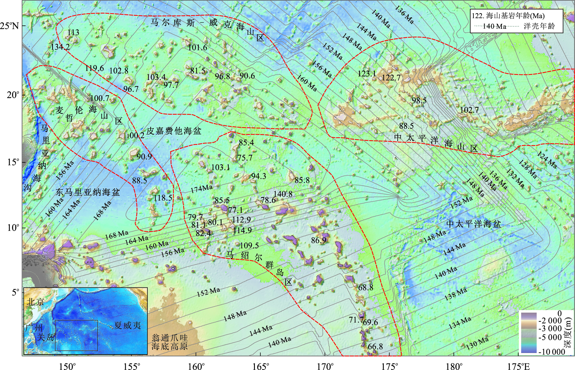
In order to discuss the differences of the formation mechanism between REE and PGE of the Co-rich Crust, in this study, rare earth elements (REE) and platinum-group elements (PGE) of the Co-rich Crusts from West Pacific Ocean Seamounts are compared and analyzed. The results show that ΣREY of Co-rich crusts ranges from 1 433.7×10⁻⁶ to 2 888.0×10⁻⁶, in which Ce accounts for nearly 50%. After being shale-normalized, REE patterns display relatively flat models but significant positive Ce anomalies. According to REE patterns and previous Nd isotope results, REE of Co-rich crusts have an affinity with continental crust attribution. Co-rich Crusts are also enriched in PGE and have rather high Pt content (115.5×10⁻⁹~1132.0×10-9), high (Pt/Pd)N and (Pt/Os)N ratios, with good correlation between Ir and Pt, Rh and Pt. After being chondrite-normalized, PGE patterns show relatively consistent models characterized by Os to Pt gradual enrichment and Pd element strong loss. Previous Os isotope of Co-rich crusts studies indicate provenance supply changes from mantle source to continental crust source, but the relative amounts of PGE internal elements remain stable in a certain extent. Our studies suggest that Co-rich crusts are selective when enriching rare earth. Ce positive anomaly in Co-rich crusts and Ce loss in seawater is probably due to the fact that Ce in seawater is favored by Co-rich crusts. Ce loss in seawater doesn t change REE patterns of the newly formed Co-rich crusts, and the reason is probably that there is large number of authigenic phosphates characterized by negative anomaly of Ce, which are similar to seawater. In theory, the supply of rare earth in seawater should reach equilibrium with consumption of rare earth in seawater by oxides and phosphates. Importantly in this reaction, the choice of oxides of REE is more active, and phosphates show more inheritance. Despite the provenance supply changing, PGE patterns of Co-rich crusts are still stable. So the fractionation of PGE from seawater to Co-rich Crusts can also be considered for selective PGE absorption. For preference of Pt and Ir, exclusion of Pd and Os, Co-rich Crusts form a unique pattern of PGE.
In order to discuss the differences of the formation mechanism between REE and PGE of the Co-rich Crust, in this study, rare earth elements (REE) and platinum-group elements (PGE) of the Co-rich Crusts from West Pacific Ocean Seamounts are compared and analyzed. The results show that ΣREY of Co-rich crusts ranges from 1 433.7×10⁻⁶ to 2 888.0×10⁻⁶, in which Ce accounts for nearly 50%. After being shale-normalized, REE patterns display relatively flat models but significant positive Ce anomalies. According to REE patterns and previous Nd isotope results, REE of Co-rich crusts have an affinity with continental crust attribution. Co-rich Crusts are also enriched in PGE and have rather high Pt content (115.5×10⁻⁹~1132.0×10-9), high (Pt/Pd)N and (Pt/Os)N ratios, with good correlation between Ir and Pt, Rh and Pt. After being chondrite-normalized, PGE patterns show relatively consistent models characterized by Os to Pt gradual enrichment and Pd element strong loss. Previous Os isotope of Co-rich crusts studies indicate provenance supply changes from mantle source to continental crust source, but the relative amounts of PGE internal elements remain stable in a certain extent. Our studies suggest that Co-rich crusts are selective when enriching rare earth. Ce positive anomaly in Co-rich crusts and Ce loss in seawater is probably due to the fact that Ce in seawater is favored by Co-rich crusts. Ce loss in seawater doesn t change REE patterns of the newly formed Co-rich crusts, and the reason is probably that there is large number of authigenic phosphates characterized by negative anomaly of Ce, which are similar to seawater. In theory, the supply of rare earth in seawater should reach equilibrium with consumption of rare earth in seawater by oxides and phosphates. Importantly in this reaction, the choice of oxides of REE is more active, and phosphates show more inheritance. Despite the provenance supply changing, PGE patterns of Co-rich crusts are still stable. So the fractionation of PGE from seawater to Co-rich Crusts can also be considered for selective PGE absorption. For preference of Pt and Ir, exclusion of Pd and Os, Co-rich Crusts form a unique pattern of PGE.


2016, 41(10): 1758-1770.
doi: 10.3799/dqkx.2016.527
Abstract:
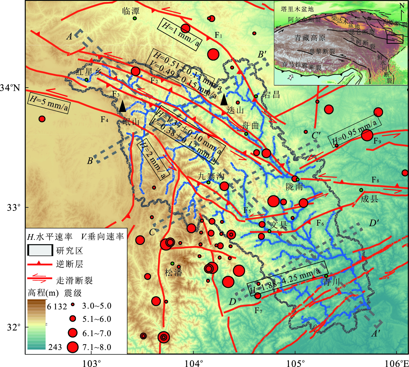
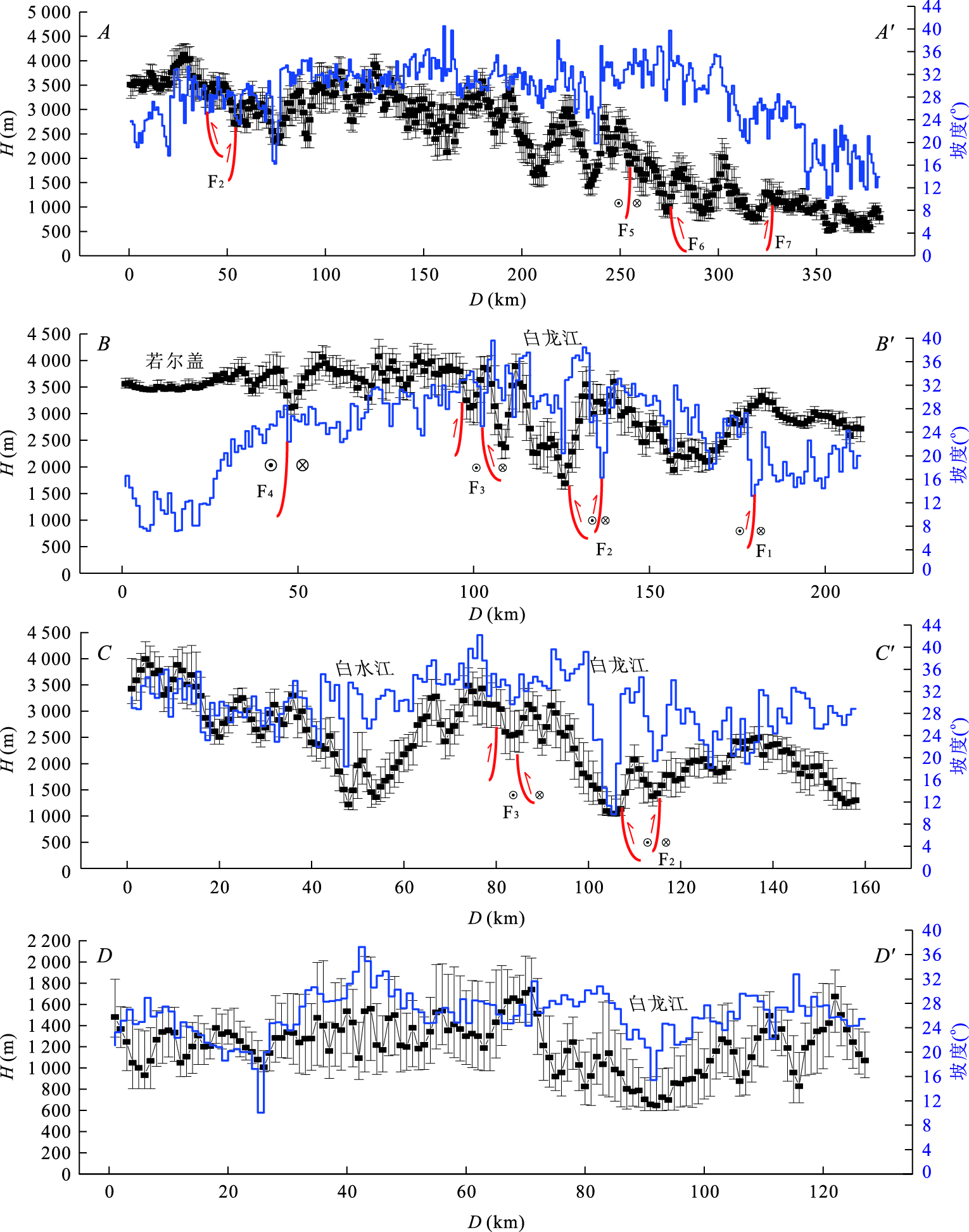
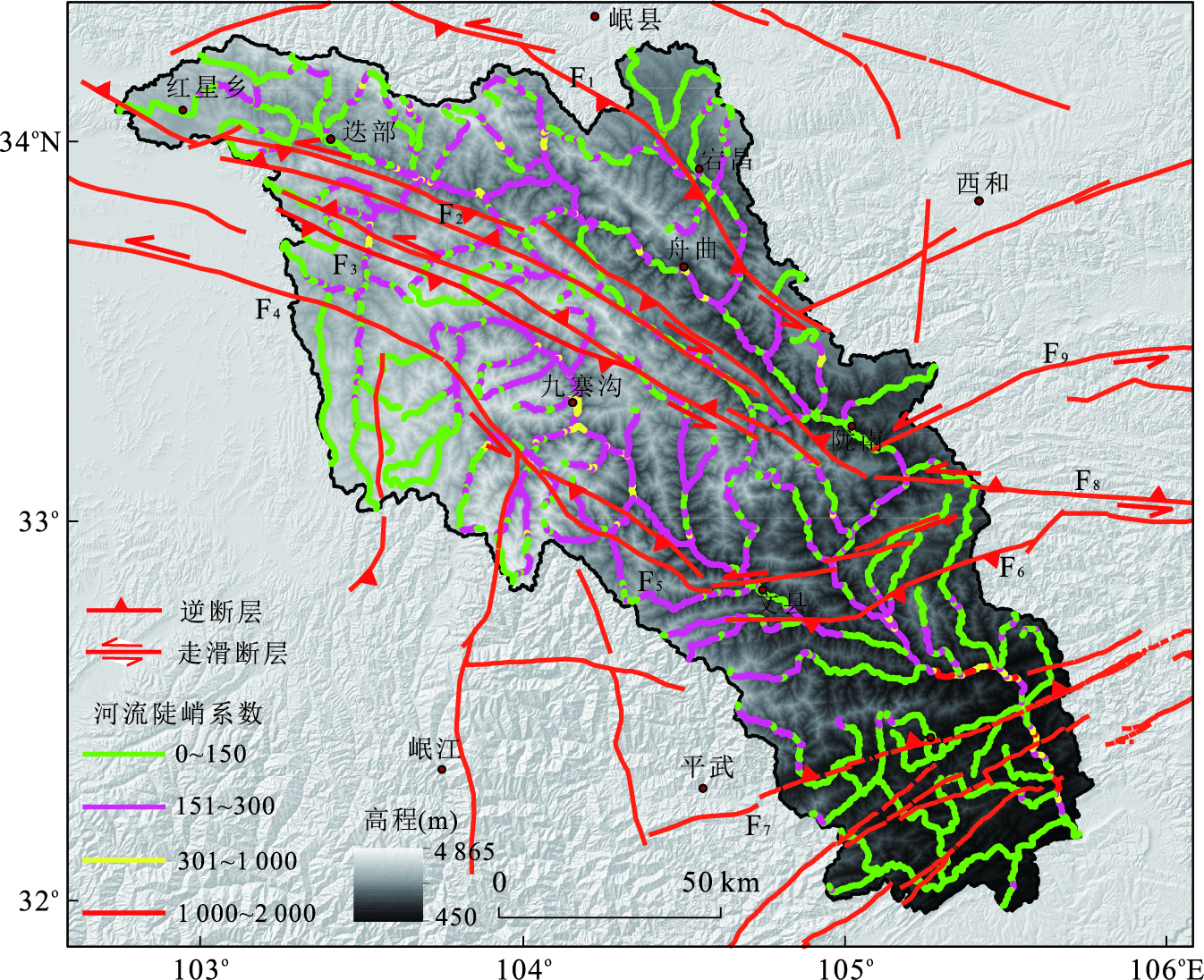
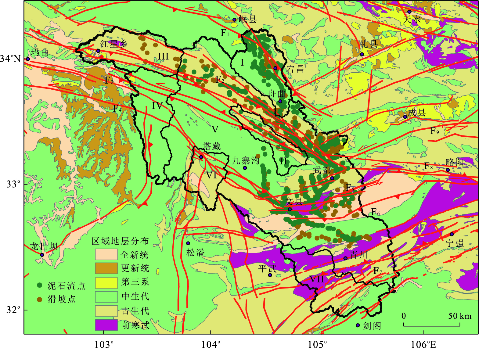
Active tectonics is one of the factor that impacts the geological disaster. In this paper, the control factors of the geological disasters (landslide and debris flow) in Bailongjiang drainage basin are studied. Based on SRTM-3 Digital Elevation Model, we make use of ArcGIS spatial analysis techniques and Matlab scripts to extract various geomorphic parameters in Bailongjiang drainage basin systematically, such as the macro landform information, seven fitting S-A graphics of four graded rivers. Combined with neotectonic features, active faults, lithological distribution and rainfall condition, the control factors of geodisasters are analyzed. The results show that the convex fitting S-A graphics represents that the material output is bigger than the material input; on the contrary, the concave fitting S-A graphics represents that the material output is less than the material input; among which, the material input performs mountain uplift and the concrete manifestation of material output is landslide, debris flow disaster produced in emergency. In addition, mylonitization or half mylonitization strata distribution controlled by regional tectonic movement is the essential factors for geological disasters. Affected by the comprehensive factors above, it is concluded that geological disasters usually occurs in the region that elevation changes rapidly, high relief amplitude and high slope distribution and different sub-basin topography caused by regional differences in uplift control the area where geological disasters occur frequently, that is, geological disasters occur frequently in the sub-basin where material output is bigger than material input and the sub-basin where material input is bigger than material output doesn't show the geological disasters distribution point.
Active tectonics is one of the factor that impacts the geological disaster. In this paper, the control factors of the geological disasters (landslide and debris flow) in Bailongjiang drainage basin are studied. Based on SRTM-3 Digital Elevation Model, we make use of ArcGIS spatial analysis techniques and Matlab scripts to extract various geomorphic parameters in Bailongjiang drainage basin systematically, such as the macro landform information, seven fitting S-A graphics of four graded rivers. Combined with neotectonic features, active faults, lithological distribution and rainfall condition, the control factors of geodisasters are analyzed. The results show that the convex fitting S-A graphics represents that the material output is bigger than the material input; on the contrary, the concave fitting S-A graphics represents that the material output is less than the material input; among which, the material input performs mountain uplift and the concrete manifestation of material output is landslide, debris flow disaster produced in emergency. In addition, mylonitization or half mylonitization strata distribution controlled by regional tectonic movement is the essential factors for geological disasters. Affected by the comprehensive factors above, it is concluded that geological disasters usually occurs in the region that elevation changes rapidly, high relief amplitude and high slope distribution and different sub-basin topography caused by regional differences in uplift control the area where geological disasters occur frequently, that is, geological disasters occur frequently in the sub-basin where material output is bigger than material input and the sub-basin where material input is bigger than material output doesn't show the geological disasters distribution point.


2016, 41(10): 1771-1780.
doi: 10.3799/dqkx.2016.525
Abstract:
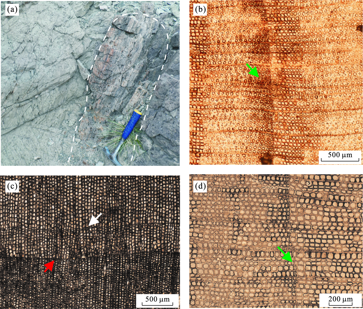
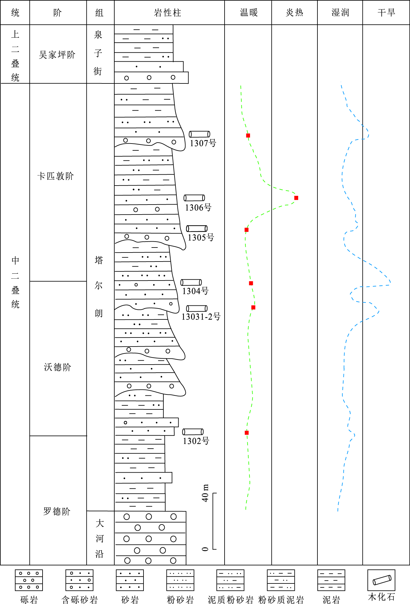
The collection of fossil wood growth rings data is helpful for rebuilding paleoclimate. Based on the statistical analysis of fossil wood growth rings from Middle Permian Taerlang Formation in the northeast edge of Tuha basin, the paleoclimate evolution of Middle Permian is reconstructed for the first time. The analysis of fossil wood growth rings shows that this area was subject to north subtropical climate with obvious seasonal variations during the Middle Permian. The paleoclimate was relatively warm, but intermittent hot climate had occurred. The low percentage of latewood and the abrupt transition between earlywood and latewood of some growth rings reflect that the seasonal variations were very obvious during the period of trees' growth. The paleoclimate was prevailed by a subtropical monsoon climate with hot and humid summer and dry and cold winter. The relatively high mean sensitivity (MS average of 0.4) of fossil woods indicates that trees were influenced by monsoon climate during the growth period, and the environment was very unstable with uneven annual precipitation. The change of consecutive growth ring width and the existence of false rings implies that the climate changed frequently and generally was humid with arid and semi-arid fluctuations.
The collection of fossil wood growth rings data is helpful for rebuilding paleoclimate. Based on the statistical analysis of fossil wood growth rings from Middle Permian Taerlang Formation in the northeast edge of Tuha basin, the paleoclimate evolution of Middle Permian is reconstructed for the first time. The analysis of fossil wood growth rings shows that this area was subject to north subtropical climate with obvious seasonal variations during the Middle Permian. The paleoclimate was relatively warm, but intermittent hot climate had occurred. The low percentage of latewood and the abrupt transition between earlywood and latewood of some growth rings reflect that the seasonal variations were very obvious during the period of trees' growth. The paleoclimate was prevailed by a subtropical monsoon climate with hot and humid summer and dry and cold winter. The relatively high mean sensitivity (MS average of 0.4) of fossil woods indicates that trees were influenced by monsoon climate during the growth period, and the environment was very unstable with uneven annual precipitation. The change of consecutive growth ring width and the existence of false rings implies that the climate changed frequently and generally was humid with arid and semi-arid fluctuations.


2016, 41(10): 1781-1793.
doi: 10.3799/dqkx.2016.125
Abstract:
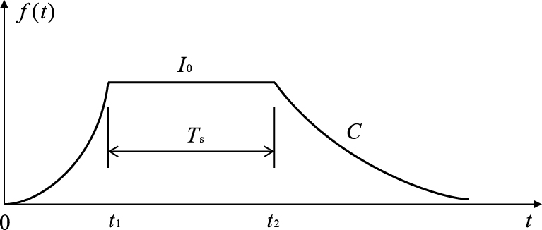
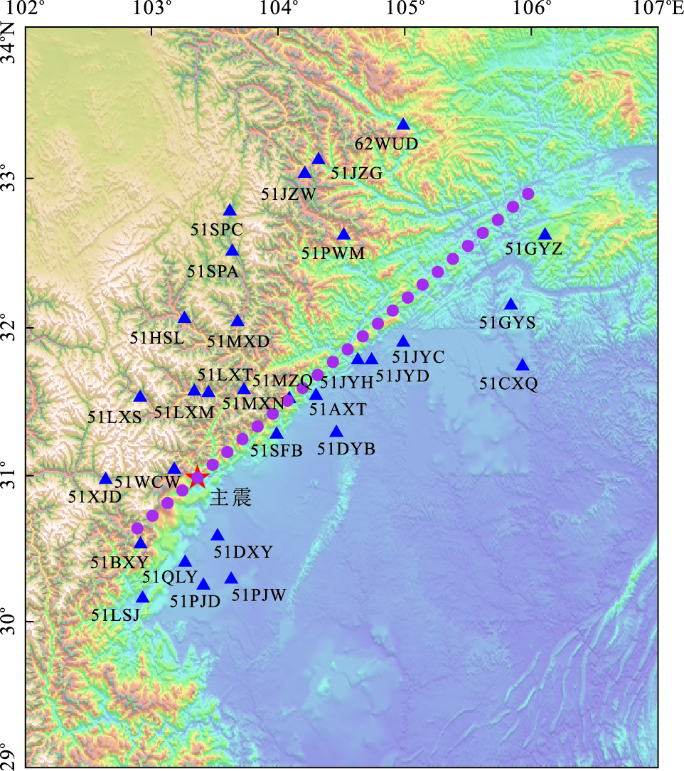
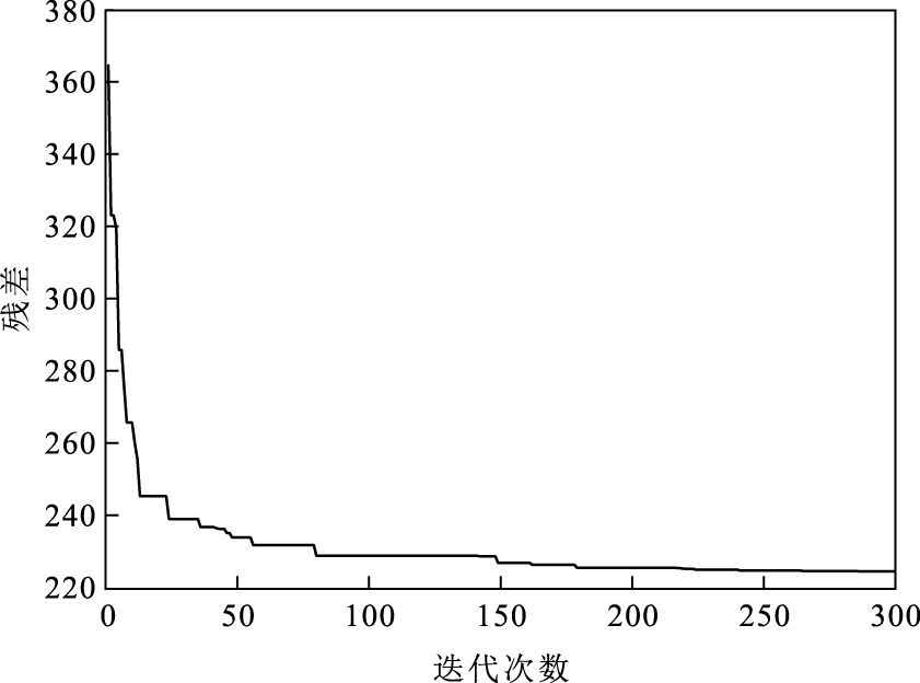
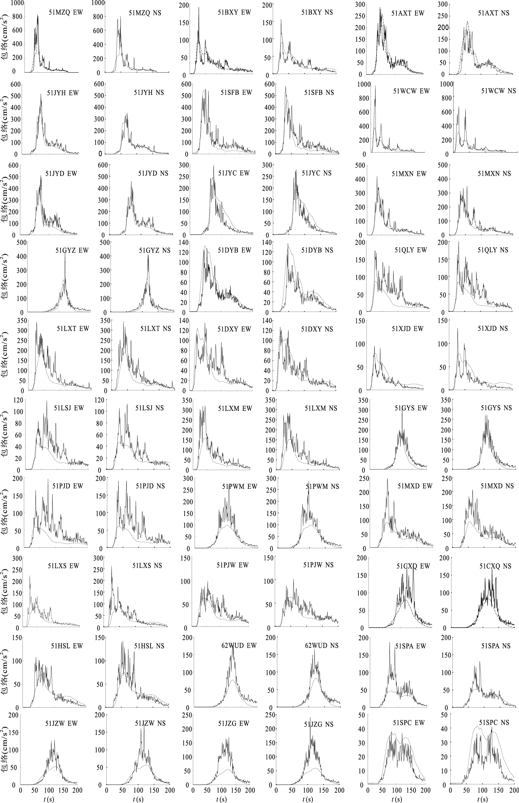
It s helpful for studying earthquake disaster by estimating seismic oscillation reasonably in Wenchuan area. Based on the line source model, the high-frequency ( > 1 Hz) wave radiation areas on the Wenchuan earthquake fault plane are inversed by the differential evolution method, using the acceleration envelopes attenuation relationship of Lushan earthquake and envelopes of 30 near-field stations acceleration seismograms in Wenchuan earthquake. The results indicate that the high-frequency wave radiation areas are very nonuniform, with most of the High-frequency waves radiated in: (1) the surface rupture areas, including Yingxiu, Beichuan and Nanba areas; (2) the areas close to the boundaries of the asperities, including that with epicentral distance from 60 to 90 km northeast of epicenter, and areas 30 km northeast of Beichuan and Nanba; (3) the area within 30 km length near the fault northeastern tip. Both high and low frequency wave radiation were much higher in areas with large surface rupture. Utilizing the inversed high-frequency wave radiation areas and the acceleration envelopes attenuation relationship, near-field accelerations are synthesized. The accelerations in areas with no seismic records are synthesized by the synthetic envelopes and a stationary stochastic process extracted from its near station with similar site conditions. The results could be used as the earthquake input for analyzing seismic damage of structures in Wenchuan earthquake.
It s helpful for studying earthquake disaster by estimating seismic oscillation reasonably in Wenchuan area. Based on the line source model, the high-frequency ( > 1 Hz) wave radiation areas on the Wenchuan earthquake fault plane are inversed by the differential evolution method, using the acceleration envelopes attenuation relationship of Lushan earthquake and envelopes of 30 near-field stations acceleration seismograms in Wenchuan earthquake. The results indicate that the high-frequency wave radiation areas are very nonuniform, with most of the High-frequency waves radiated in: (1) the surface rupture areas, including Yingxiu, Beichuan and Nanba areas; (2) the areas close to the boundaries of the asperities, including that with epicentral distance from 60 to 90 km northeast of epicenter, and areas 30 km northeast of Beichuan and Nanba; (3) the area within 30 km length near the fault northeastern tip. Both high and low frequency wave radiation were much higher in areas with large surface rupture. Utilizing the inversed high-frequency wave radiation areas and the acceleration envelopes attenuation relationship, near-field accelerations are synthesized. The accelerations in areas with no seismic records are synthesized by the synthetic envelopes and a stationary stochastic process extracted from its near station with similar site conditions. The results could be used as the earthquake input for analyzing seismic damage of structures in Wenchuan earthquake.


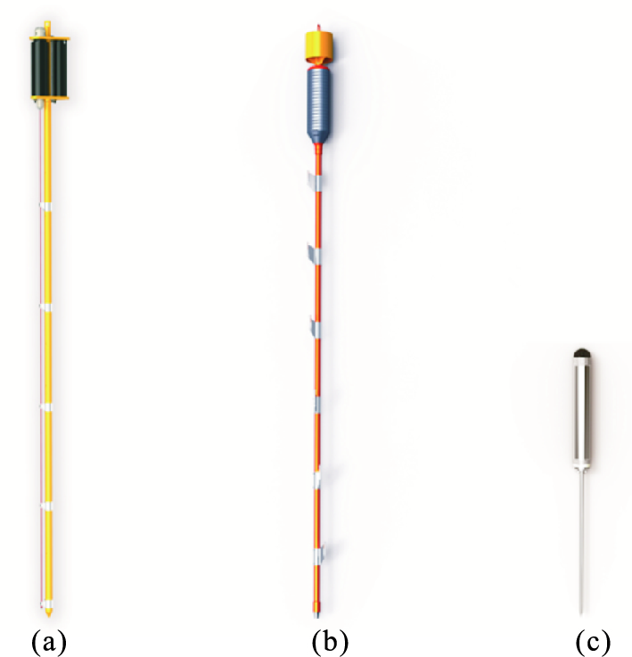
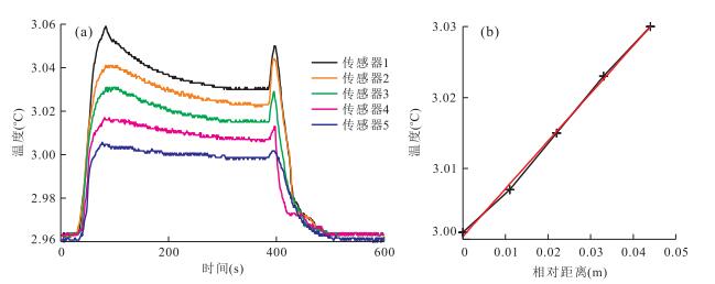
2016, 41(10): 1794-1802.
doi: 10.3799/dqkx.2016.126
Abstract:
A seafloor fluid-seep area is generally small, and is characterized by rich mineral resources, active fluid seep and complex geological background. In order to reveal fluid flowing features and to explore mineral resources in fluid-seep areas, precise measurement of heat flow in fluid seep areas is important. This paper describes technical parameters of common heat flow probes and general characteristics of heat flow in seafloor fluid-seep areas. Recent marine geological survey has proved that a heat flow probe operated by a robot has been successfully applied for quick and precise measurement of the heat flow in the seafloor fluid-seep area.
A seafloor fluid-seep area is generally small, and is characterized by rich mineral resources, active fluid seep and complex geological background. In order to reveal fluid flowing features and to explore mineral resources in fluid-seep areas, precise measurement of heat flow in fluid seep areas is important. This paper describes technical parameters of common heat flow probes and general characteristics of heat flow in seafloor fluid-seep areas. Recent marine geological survey has proved that a heat flow probe operated by a robot has been successfully applied for quick and precise measurement of the heat flow in the seafloor fluid-seep area.