2016 Vol. 41, No. 11
Display Method:
 PDF 233KB
2016, 41(11): 1803-1829.
doi: 10.3799/dqkx.2016.550
Abstract:
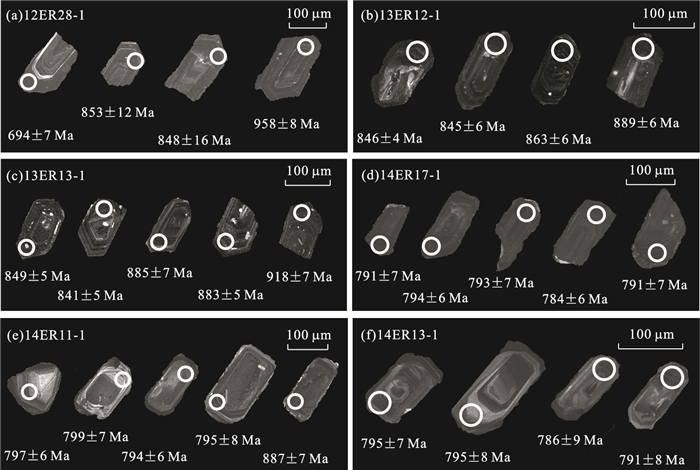
This paper presents LA-ICP-MS zircon U-Pb dating, major and trace elements, and Hf isotope data of the Neoproterozoic granitoids in the Erguna Massif with the aim of constraining the Neoproterozoic tectonic evolution and tectonic attribution of the Erguna Massif. Zircons from these granitoids are of magmatic origin in accordance with CL images and high Th/U ratios (0.17-1.46). The zircon dating results, together with previously published age data, demonstrate that the Neoproterozoic magmatisms in the Erguna Massif can be subdivided into seven stages: about 929 Ma, about 887 Ma, about 850 Ma, about 819 Ma, about 792 Ma, about 764 Ma and about 738 Ma. Geochemically, about 887 Ma granites are similar to those of post-collisional granites, whereas 850-737 Ma granitoids are similar generally to A-type granites, except for some samples (collected from Mohe, Amuer, Bishui and Shiwei plutons) which are similar to I-type granites. Zircon Hf isotopic compositions indicate that their primary magmas could have originated not only by partial melting of a depleted lower crust that accreated during the Meso-Neoproterozoic (TDM2=884-1 563 Ma), with a contribution of ancient crustal material in their petrogenesis, but also by partial melting of the residual ancient mafic crustal material. These geochemical data, combined with the published data and the global magmatic-tectonic-thermal events, indicate that Neoproterozoic magmatic events within the Erguna Massif recorded crustal evolution as a result of the assembly and breakup of the Rodinia supercontinent: magmatisms between 927 Ma and 880 Ma were the result of collision-orogeny during the stage of assembly of the Rodinia supercontinent, whereas the 850-737 Ma magmatisms recorded the breakup of the Rodinia supercontinent. The Erguna Massif has an affinity to the adjacent massifs (e.g. Central Mongolia and Tuva massifs) near the southern margin of the Siberian block, and is similar to the Tarim and South China blocks at least in terms of these Neoproterozoic magmatic events, but obviously different from the North China and Siberian blocks.
This paper presents LA-ICP-MS zircon U-Pb dating, major and trace elements, and Hf isotope data of the Neoproterozoic granitoids in the Erguna Massif with the aim of constraining the Neoproterozoic tectonic evolution and tectonic attribution of the Erguna Massif. Zircons from these granitoids are of magmatic origin in accordance with CL images and high Th/U ratios (0.17-1.46). The zircon dating results, together with previously published age data, demonstrate that the Neoproterozoic magmatisms in the Erguna Massif can be subdivided into seven stages: about 929 Ma, about 887 Ma, about 850 Ma, about 819 Ma, about 792 Ma, about 764 Ma and about 738 Ma. Geochemically, about 887 Ma granites are similar to those of post-collisional granites, whereas 850-737 Ma granitoids are similar generally to A-type granites, except for some samples (collected from Mohe, Amuer, Bishui and Shiwei plutons) which are similar to I-type granites. Zircon Hf isotopic compositions indicate that their primary magmas could have originated not only by partial melting of a depleted lower crust that accreated during the Meso-Neoproterozoic (TDM2=884-1 563 Ma), with a contribution of ancient crustal material in their petrogenesis, but also by partial melting of the residual ancient mafic crustal material. These geochemical data, combined with the published data and the global magmatic-tectonic-thermal events, indicate that Neoproterozoic magmatic events within the Erguna Massif recorded crustal evolution as a result of the assembly and breakup of the Rodinia supercontinent: magmatisms between 927 Ma and 880 Ma were the result of collision-orogeny during the stage of assembly of the Rodinia supercontinent, whereas the 850-737 Ma magmatisms recorded the breakup of the Rodinia supercontinent. The Erguna Massif has an affinity to the adjacent massifs (e.g. Central Mongolia and Tuva massifs) near the southern margin of the Siberian block, and is similar to the Tarim and South China blocks at least in terms of these Neoproterozoic magmatic events, but obviously different from the North China and Siberian blocks.


2016, 41(11): 1830-1844.
doi: 10.3799/dqkx.2016.127
Abstract:
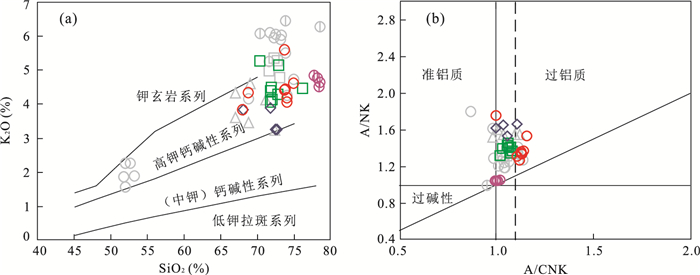
In order to research the Variscan tectonic evolution features of Dachaidan region in North Qaidam, this paper presents LA-ICP-MS zircon U-Pb dating, geochemical and Hf isotopic data of the granite porphyry from Tanjianshan intrusion in Dachaidan region, with the aim of constraining its formation time, petrogenesis and the regional tectonic setting. The LA-ICP-MS U-Pb dating results of zircons from the granite porphyry indicate that the intrusion formed in the Late Devonian Epoch (356.0±2.8 Ma, MSWD=0.53). Geochemically, these rocks fall into the calc-alkaline to middle-K calc-alkaline series, with an A/CNK ratio of 0.97-1.10, which are weakly peraluminous granites, being of the characteristics of I type granitoids, enriched in LILE(such as K, Ba, Rb), LREE, Th and U, relatively depleted in HFSE (such as Ta, Nb, Ti, P). The εHf(t) values of the granite porphyry vary from ±5.43 to ±8.38, and two-stage model ages (TDM2) range from 1 017 to 1 284 Ma. These characteristics suggest that the primary magma was derived from the remelting of juvenile crustal materials in Mesoproterozoic. In context of its regional geological background, we conclude the granite porphyry from Tanjianshan intrusion were formed extensional tectonic setting after the collision between Qaidam block and Qilian block.
In order to research the Variscan tectonic evolution features of Dachaidan region in North Qaidam, this paper presents LA-ICP-MS zircon U-Pb dating, geochemical and Hf isotopic data of the granite porphyry from Tanjianshan intrusion in Dachaidan region, with the aim of constraining its formation time, petrogenesis and the regional tectonic setting. The LA-ICP-MS U-Pb dating results of zircons from the granite porphyry indicate that the intrusion formed in the Late Devonian Epoch (356.0±2.8 Ma, MSWD=0.53). Geochemically, these rocks fall into the calc-alkaline to middle-K calc-alkaline series, with an A/CNK ratio of 0.97-1.10, which are weakly peraluminous granites, being of the characteristics of I type granitoids, enriched in LILE(such as K, Ba, Rb), LREE, Th and U, relatively depleted in HFSE (such as Ta, Nb, Ti, P). The εHf(t) values of the granite porphyry vary from ±5.43 to ±8.38, and two-stage model ages (TDM2) range from 1 017 to 1 284 Ma. These characteristics suggest that the primary magma was derived from the remelting of juvenile crustal materials in Mesoproterozoic. In context of its regional geological background, we conclude the granite porphyry from Tanjianshan intrusion were formed extensional tectonic setting after the collision between Qaidam block and Qilian block.


2016, 41(11): 1845-1862.
doi: 10.3799/dqkx.2016.128
Abstract:
The study region locates in the southwest margin of Central Asian Orogenic belt, which recorded several volcanic events of different tectonic environment. The volcanic rocks from Late Carboniferous Batamayineishan Formation includes the alkaline series and sub-alkaline series, which formed in 320.2±4.2 Ma. They have a SiO2 interrupt ranging from 56% to 67.5%. The basaltic rocks and the felsic rocks are closely associated. They show a typical characteristic of bimodal volcanic rocks. Their geochemistry and isotope characteristics suggesting that the basaltic rocks come from a depleted mantle source whereas the felsic rocks come from a source due to anatectic melting of the lower crust and show characteristic of A-type granites. The assemblages of volcanic rocks and the geochemical information of volcanic rocks from Batamayineishan Formation indicate they formed in apost-collision environment. Combining the research results ofthis region, the authors consider the Batamayineishan Formation were generated mainly in the end stage of post-collision of Kalamaili orogenic, which began after cessation of collision, and involved extensional detachment of the thickened lithosphere, leading to extension and thinning of the crust.
The study region locates in the southwest margin of Central Asian Orogenic belt, which recorded several volcanic events of different tectonic environment. The volcanic rocks from Late Carboniferous Batamayineishan Formation includes the alkaline series and sub-alkaline series, which formed in 320.2±4.2 Ma. They have a SiO2 interrupt ranging from 56% to 67.5%. The basaltic rocks and the felsic rocks are closely associated. They show a typical characteristic of bimodal volcanic rocks. Their geochemistry and isotope characteristics suggesting that the basaltic rocks come from a depleted mantle source whereas the felsic rocks come from a source due to anatectic melting of the lower crust and show characteristic of A-type granites. The assemblages of volcanic rocks and the geochemical information of volcanic rocks from Batamayineishan Formation indicate they formed in apost-collision environment. Combining the research results ofthis region, the authors consider the Batamayineishan Formation were generated mainly in the end stage of post-collision of Kalamaili orogenic, which began after cessation of collision, and involved extensional detachment of the thickened lithosphere, leading to extension and thinning of the crust.


2016, 41(11): 1863-1882.
doi: 10.3799/dqkx.2016.129
Abstract:
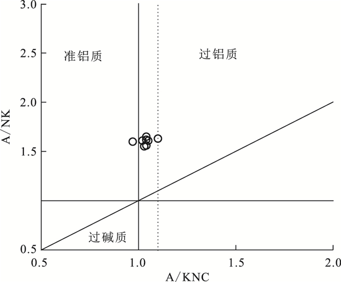
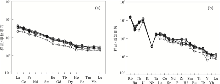
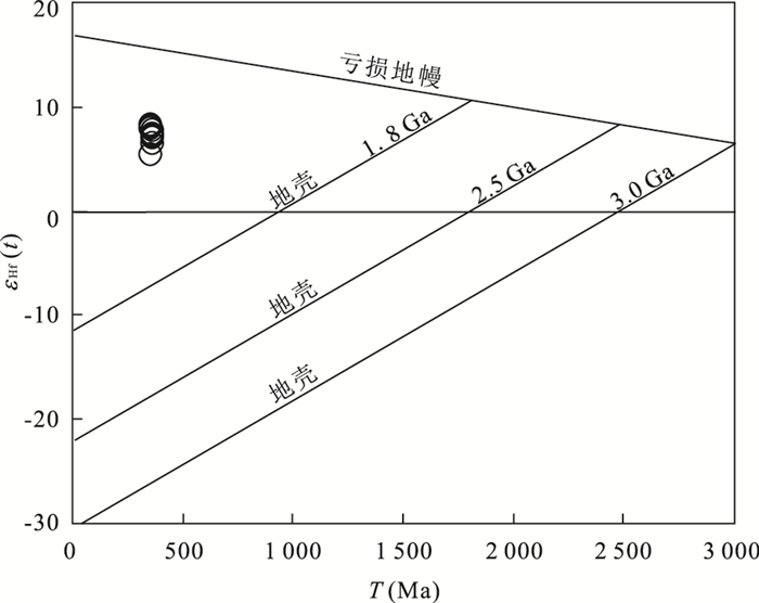
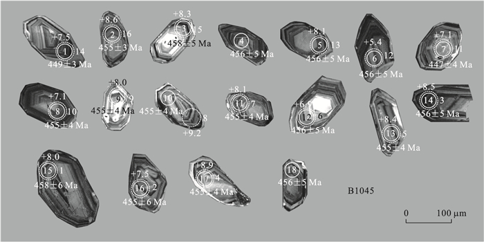
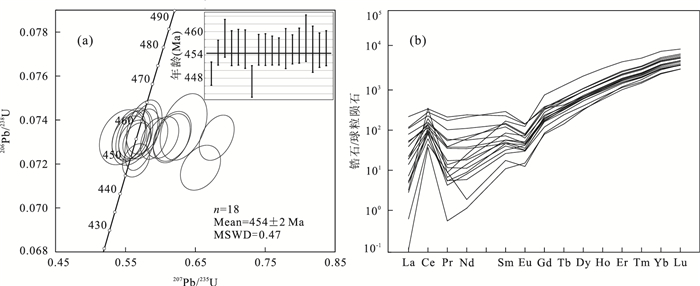
The Aowade granodiorited in the east-end of Kunnan terrain, a part of Kunlun Orogenic belt, belongs to Proto-Tethyan tectonic domain. Detailed study of the granodiorite can offer important information to constrain the evolution of the Proto-Tethys Ocean. Detailer study of the granodiorite can offer important information to constrain the evolution of the Proto-Tethys Ocean. In this study, LA-ICP-MS zircon U-Pb dating yields a weighted mean age of 454±2 Ma for the intrusion. It is characterized by low K2O/Na2O (0.92-2.68) and Mg# (39-43), and the A/CNK is between 1.00 and 1.03. The REE exhibits right-dipping patterns with negative anomalies of Eu/Eu*(0.48-0.96) and high (La/Yb)N ratios. LILE(Rb, Ba, K, La, Sr) is enriched in this intrusion, while HFSE(Nb, Ta, P, Ti) is depleted relative to the primitive mantle, and the concentrations of transition elements such as Cr and Ni are low. The ratios of Sr/Y (average of 55) are relatively high. All the samples have high initial 87Sr/86Sr values (0.705 9-0.706 3) and εHf(t) (+5.4 to +9.2), but with relatively low εNd(t)(-4.1 to -1.9) and old two stage model age (T2DMNd=1.3-1.5 Ga). In combination with the lithology, geochemical signature and isotopic compositions of the intrusion, we propose that the Aowade granodiorite was derived from melting of the subducted oceanic crust with minor involvement of continent crust. The possible residual of the source region is garnet amphibolite. Fractional crystallization of pyroxene, amphibole and plagioclase may have also occurred during the evolution of magma. Integrating evidences from the geodynamic setting of the Aowade granodiorite, the ophiolites in the Kunzhong structure zone, and the metamorphic rocks, arc-related igneous rocks on either side of the Kunzhong structure zone, it is concluded that the Aowade granodiorite was formed during the subduction of Proto-Tethys Ocean, which further reveals the nature of bidirectional subduction of the Proto-Tethys in the Late Ordovician.
The Aowade granodiorited in the east-end of Kunnan terrain, a part of Kunlun Orogenic belt, belongs to Proto-Tethyan tectonic domain. Detailed study of the granodiorite can offer important information to constrain the evolution of the Proto-Tethys Ocean. Detailer study of the granodiorite can offer important information to constrain the evolution of the Proto-Tethys Ocean. In this study, LA-ICP-MS zircon U-Pb dating yields a weighted mean age of 454±2 Ma for the intrusion. It is characterized by low K2O/Na2O (0.92-2.68) and Mg# (39-43), and the A/CNK is between 1.00 and 1.03. The REE exhibits right-dipping patterns with negative anomalies of Eu/Eu*(0.48-0.96) and high (La/Yb)N ratios. LILE(Rb, Ba, K, La, Sr) is enriched in this intrusion, while HFSE(Nb, Ta, P, Ti) is depleted relative to the primitive mantle, and the concentrations of transition elements such as Cr and Ni are low. The ratios of Sr/Y (average of 55) are relatively high. All the samples have high initial 87Sr/86Sr values (0.705 9-0.706 3) and εHf(t) (+5.4 to +9.2), but with relatively low εNd(t)(-4.1 to -1.9) and old two stage model age (T2DMNd=1.3-1.5 Ga). In combination with the lithology, geochemical signature and isotopic compositions of the intrusion, we propose that the Aowade granodiorite was derived from melting of the subducted oceanic crust with minor involvement of continent crust. The possible residual of the source region is garnet amphibolite. Fractional crystallization of pyroxene, amphibole and plagioclase may have also occurred during the evolution of magma. Integrating evidences from the geodynamic setting of the Aowade granodiorite, the ophiolites in the Kunzhong structure zone, and the metamorphic rocks, arc-related igneous rocks on either side of the Kunzhong structure zone, it is concluded that the Aowade granodiorite was formed during the subduction of Proto-Tethys Ocean, which further reveals the nature of bidirectional subduction of the Proto-Tethys in the Late Ordovician.


2016, 41(11): 1883-1892.
doi: 10.3799/dqkx.2016.130
Abstract:
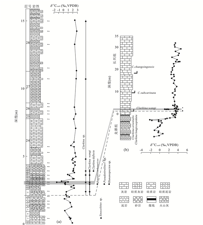
The research of conodont biostratigraphy and carbon isotope change at the Dawoling section provides basic materials for the exploration of creatures and environment change in the Wuchiapingian-Changhsigian period. The Dawoling section at Yuanjia Town, Jiahe county, Hunan Province, recorded basinal deposition during the Late Permian. The Talung Formation is well-exposed and displays siliceous rock, siliceous limestone, limestone and claystone. Three conodont taxa (one is undetermined) of genus Clarkina: C. wangi, C. deflecta and C. sp. are identified, and these enable the tentative assignment of a C. wangi Zone overlain by a C. changxingensis-C. deflecta assemblage Zone. The Wuchiapingian-Changhsingian boundary (Wuchiapingian-Changhsingian boundary, WCB) is placed at the first occurrence (FO) of C. wangi at the base of bed 11 at this Dawoling section. A rapid negative shift from 2.18‰ to -1.39‰ in carbonate carbon isotope in beds 13-15 correlates well with the Changhsingian GSSP(Global Stratotype Section and Point) section at Meishan in Zhejiang and the Shangsi section of Sichuan. Therefore, this negative excursion could be a regionally correlation horizon in south China.
The research of conodont biostratigraphy and carbon isotope change at the Dawoling section provides basic materials for the exploration of creatures and environment change in the Wuchiapingian-Changhsigian period. The Dawoling section at Yuanjia Town, Jiahe county, Hunan Province, recorded basinal deposition during the Late Permian. The Talung Formation is well-exposed and displays siliceous rock, siliceous limestone, limestone and claystone. Three conodont taxa (one is undetermined) of genus Clarkina: C. wangi, C. deflecta and C. sp. are identified, and these enable the tentative assignment of a C. wangi Zone overlain by a C. changxingensis-C. deflecta assemblage Zone. The Wuchiapingian-Changhsingian boundary (Wuchiapingian-Changhsingian boundary, WCB) is placed at the first occurrence (FO) of C. wangi at the base of bed 11 at this Dawoling section. A rapid negative shift from 2.18‰ to -1.39‰ in carbonate carbon isotope in beds 13-15 correlates well with the Changhsingian GSSP(Global Stratotype Section and Point) section at Meishan in Zhejiang and the Shangsi section of Sichuan. Therefore, this negative excursion could be a regionally correlation horizon in south China.


2016, 41(11): 1893-1908.
doi: 10.3799/dqkx.2016.131
Abstract:
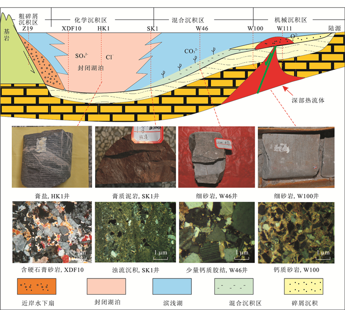
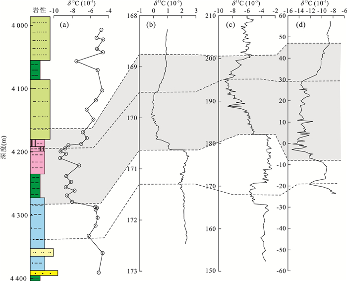
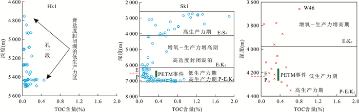
Paleocene Eocene climate (PETM) events in Early Paleogene period on the Earth had serious impact on the global carbon cycle process and the terrestrial and marine ecological environment system. In this paper, on the basis of general thin-sections, elemental analysis, carbon isotope, TOC et al., the impact of Paleocene Eocene lake environment of Jiyang rifted basin, Bohai bay on the temporal and spatial variation and response of "PETM" is studied, and it is found Jiyang basin experienced early multicycle evolution processes, detrital material and chemical differentiation occurred at the same time in lacustrine basin, and terrestrial weathering and chemical sedimentary differentiation indicates the change of extreme climate. In this period, the lake water experienced gradual salinization characterized by the spatial zoning and time-evolution stage, which is a direct response to the occurrence of hot climate events. Time-space evolution of the lake was subject to "PETM" events. The lake was not fully salty in the early events with prosperous plankton. Early phytoplankton absorption of 12CO2 led to the higher productivity in the ancient Lake, which dropped to a minimum with the lake turning increasingly salty and more difficult for the survival. δ13C of lacustrine sedimentary records are in obvious negative bias due to excessive 12C absorption and precipitation, resulting in, a maximum of 5‰. It is confirmed that global "PETM" events affected the time-space evolution and differentiation process of material in Jiyang depression during Paleocene-Eocene.
Paleocene Eocene climate (PETM) events in Early Paleogene period on the Earth had serious impact on the global carbon cycle process and the terrestrial and marine ecological environment system. In this paper, on the basis of general thin-sections, elemental analysis, carbon isotope, TOC et al., the impact of Paleocene Eocene lake environment of Jiyang rifted basin, Bohai bay on the temporal and spatial variation and response of "PETM" is studied, and it is found Jiyang basin experienced early multicycle evolution processes, detrital material and chemical differentiation occurred at the same time in lacustrine basin, and terrestrial weathering and chemical sedimentary differentiation indicates the change of extreme climate. In this period, the lake water experienced gradual salinization characterized by the spatial zoning and time-evolution stage, which is a direct response to the occurrence of hot climate events. Time-space evolution of the lake was subject to "PETM" events. The lake was not fully salty in the early events with prosperous plankton. Early phytoplankton absorption of 12CO2 led to the higher productivity in the ancient Lake, which dropped to a minimum with the lake turning increasingly salty and more difficult for the survival. δ13C of lacustrine sedimentary records are in obvious negative bias due to excessive 12C absorption and precipitation, resulting in, a maximum of 5‰. It is confirmed that global "PETM" events affected the time-space evolution and differentiation process of material in Jiyang depression during Paleocene-Eocene.


Geochemical Characteristics of Crude Oil and Oil-Source Correlation in the Western Fushan Depression
2016, 41(11): 1909-1920.
doi: 10.3799/dqkx.2016.132
Abstract:
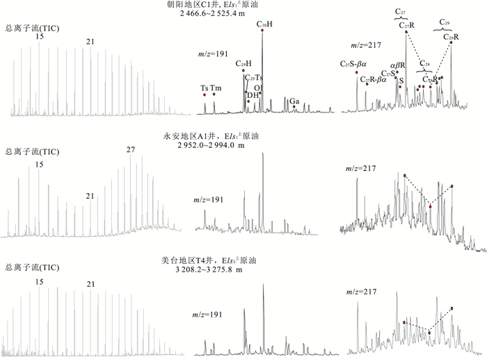
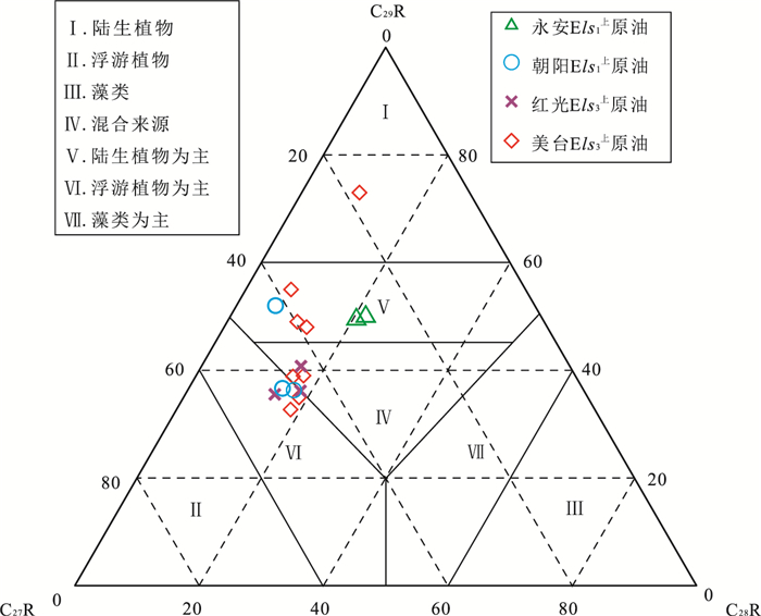
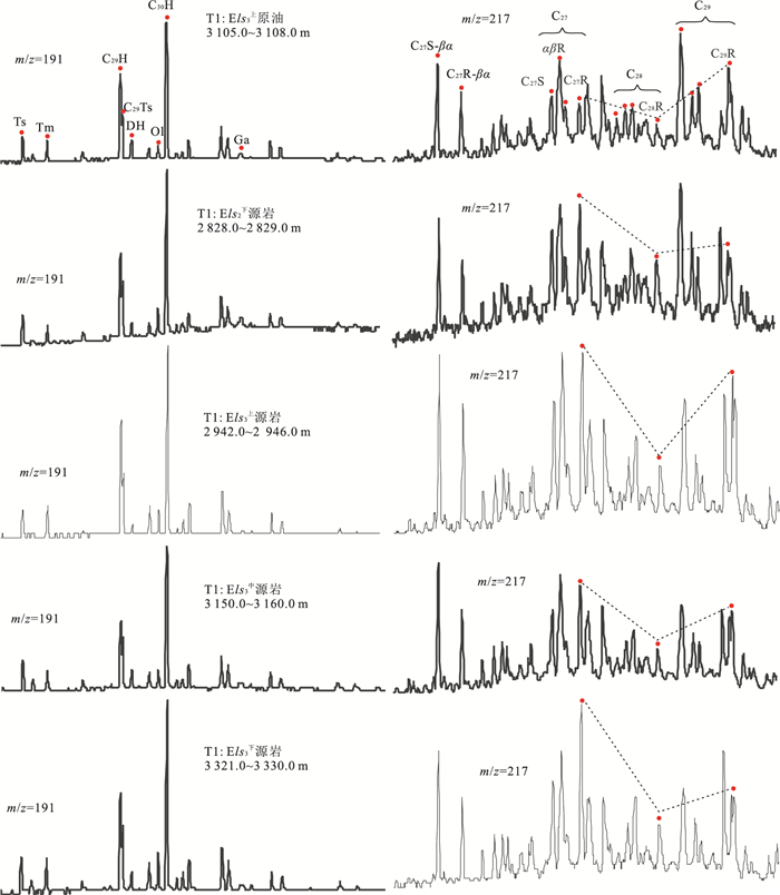
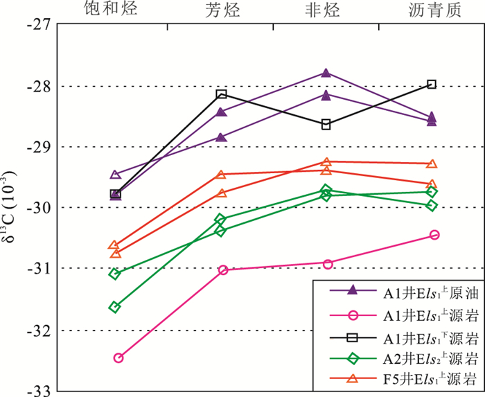
Fushan depression is a small and resource-rich petroltferous depression, and becomes one of the significant petroleum units in Beibuwan Basin. Making full use of organic geochemical data from source rock and oil, the paper focuses on the geochemical characteristics of crude oil in the western Fushan depression which few documents mentioned, and probes into the source of typical reservoirs. It is shown that the petroleum is mainly light oil with high content of saturated hydrocarbon and aromatic and low content of asphaltene and non-hydrocarbon matter. The kerogen is made up of terrestrial higher plants mixed with lower aquatic organisms, and is typical of the hybrid sources just as that of continental basin. The feature of kerogen from different area and layers are diversity. The sedimentary environment is partial oxidation and freshwater lacustrine. Combined with maturity of petroleum, the crude oil can be classified as three categories. The first class of oil is characteristic of medium maturity and low content of Ol occurred in the upper part of Third Member of Liushagang Formation (Els3). The second class is found in upper part of First Member in Liushanggang Formation (Els1) in Yong'an area, with high maturity and high content of Oleane (Ol). The third class also comes from upper part of Els1 in Chaoyang area, and its maturity is low with the medium content of Ol. Further studies on the oil-source correlation indicated that the oil in Els3 originates from the source rock in the Els3 and lower part of Els2 in Meitai and Hongguang area, and the source rock from Els1 in Yong'an area is the main oil source for the oil in Els1.
Fushan depression is a small and resource-rich petroltferous depression, and becomes one of the significant petroleum units in Beibuwan Basin. Making full use of organic geochemical data from source rock and oil, the paper focuses on the geochemical characteristics of crude oil in the western Fushan depression which few documents mentioned, and probes into the source of typical reservoirs. It is shown that the petroleum is mainly light oil with high content of saturated hydrocarbon and aromatic and low content of asphaltene and non-hydrocarbon matter. The kerogen is made up of terrestrial higher plants mixed with lower aquatic organisms, and is typical of the hybrid sources just as that of continental basin. The feature of kerogen from different area and layers are diversity. The sedimentary environment is partial oxidation and freshwater lacustrine. Combined with maturity of petroleum, the crude oil can be classified as three categories. The first class of oil is characteristic of medium maturity and low content of Ol occurred in the upper part of Third Member of Liushagang Formation (Els3). The second class is found in upper part of First Member in Liushanggang Formation (Els1) in Yong'an area, with high maturity and high content of Oleane (Ol). The third class also comes from upper part of Els1 in Chaoyang area, and its maturity is low with the medium content of Ol. Further studies on the oil-source correlation indicated that the oil in Els3 originates from the source rock in the Els3 and lower part of Els2 in Meitai and Hongguang area, and the source rock from Els1 in Yong'an area is the main oil source for the oil in Els1.


2016, 41(11): 1921-1934.
doi: 10.3799/dqkx.2016.133
Abstract:
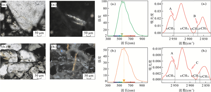
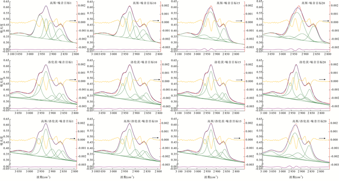
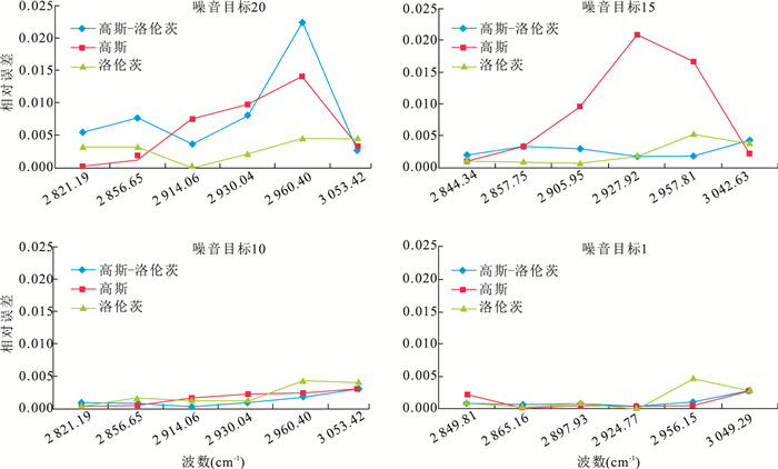
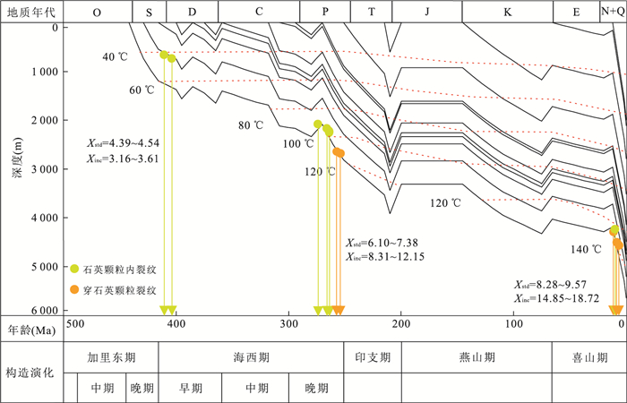
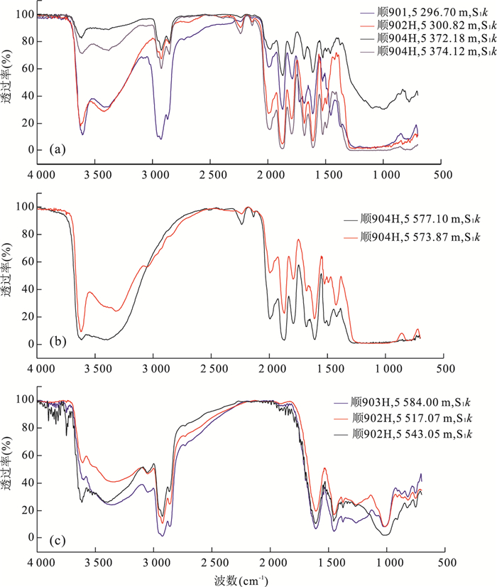
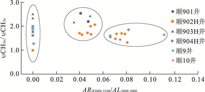
Curve-fitting analysis of micro FT-IR, in the theory of Gaussian, Lorentz function or their combination (Gaussian-Lorentz) model, can break through the limit of overlapping spectra resulting from complicated structures of samples (e.g. individual oil inclusion and bitumens). Hence, curve-fitting analysis of micro FT-IR was used for analyzing maturity of individual oil inclusion and the origin of bitumens in Shuntuoguole area of Tazhong northeastern slope systematically, and four conclusions have been obtained: firstly, curve-fitting analysis of micro FT-IR may be more accurate for calculating absorption peaks, and some easily neglected peaks can be detected by this method in contrast with the method of interval oriented by Pironon. Secondly, Gaussian-Lorentz fitting is more approaching to actual spectra and the lower noise level is corresponding to better fit but requiring longer computation time. As a result, Gaussian-Lorentz fitting with 1~10 noise level is preferred. Thirdly, based on inclusion system analysis and burial history projection with homogenization temperature, infrared parameters (e.g. CH2a/CH3a, Xinc and Xstd) reveal three hydrocarbon charging events occurred, including Late Caledonian, Late Hercynian and the Himalaya. Finally, micro FT-IR is an effective means for analyzing multi-hydrocarbon charging events and complicated origin of bitumens undergoing biodegradation, oxidative degradation and water eluviation quantitatively in study area.
Curve-fitting analysis of micro FT-IR, in the theory of Gaussian, Lorentz function or their combination (Gaussian-Lorentz) model, can break through the limit of overlapping spectra resulting from complicated structures of samples (e.g. individual oil inclusion and bitumens). Hence, curve-fitting analysis of micro FT-IR was used for analyzing maturity of individual oil inclusion and the origin of bitumens in Shuntuoguole area of Tazhong northeastern slope systematically, and four conclusions have been obtained: firstly, curve-fitting analysis of micro FT-IR may be more accurate for calculating absorption peaks, and some easily neglected peaks can be detected by this method in contrast with the method of interval oriented by Pironon. Secondly, Gaussian-Lorentz fitting is more approaching to actual spectra and the lower noise level is corresponding to better fit but requiring longer computation time. As a result, Gaussian-Lorentz fitting with 1~10 noise level is preferred. Thirdly, based on inclusion system analysis and burial history projection with homogenization temperature, infrared parameters (e.g. CH2a/CH3a, Xinc and Xstd) reveal three hydrocarbon charging events occurred, including Late Caledonian, Late Hercynian and the Himalaya. Finally, micro FT-IR is an effective means for analyzing multi-hydrocarbon charging events and complicated origin of bitumens undergoing biodegradation, oxidative degradation and water eluviation quantitatively in study area.


2016, 41(11): 1935-1949.
doi: 10.3799/dqkx.2016.134
Abstract:
During the early stage of the Palaeogene, the Shaleitian uplift and its surrounding areas constituted a complete source-to-sink system. In this paper, we analysze the characteristics of Pre-Palaeogene bedrocks and sediment-dispersal patterns of the source-to-sink systems based on detritus, thin section, zircon and integrated seismic-logging data analysis. The results show that the Shaleitian uplift was filled by Archeozoic and Proterozoic metamorphic rock sediments, and Lower Palaeozoic carbonate rocks stacked with southward Mesozoic igneous rocks. The bedrocks mainly consist of Proterozoic metamorphic rocks in the southern part of eastern Shaleitian uplift, while the Lower Palaeozoic carbonate rocks in the northern part of western Shaleitian uplift. Based on the palaeogeomorphology, it is found a sand-rich area corresponds to a complete source-to-sink coupling system in the rift basin, and the stacked style and size of sandbodies in the sink are jointly controlled by the composition of bedrocks, catchment areas, sediment-transport pathways, fracture system and detritus accommodation space. It is concluded thateffective source-to-sink systems are mainly located in the southern part of the eastern Shaleitian uplift through comparative analysis of the coupling relationship among the various controls with sandbodies properties in the Shaleitian uplift and surrounding areas.
During the early stage of the Palaeogene, the Shaleitian uplift and its surrounding areas constituted a complete source-to-sink system. In this paper, we analysze the characteristics of Pre-Palaeogene bedrocks and sediment-dispersal patterns of the source-to-sink systems based on detritus, thin section, zircon and integrated seismic-logging data analysis. The results show that the Shaleitian uplift was filled by Archeozoic and Proterozoic metamorphic rock sediments, and Lower Palaeozoic carbonate rocks stacked with southward Mesozoic igneous rocks. The bedrocks mainly consist of Proterozoic metamorphic rocks in the southern part of eastern Shaleitian uplift, while the Lower Palaeozoic carbonate rocks in the northern part of western Shaleitian uplift. Based on the palaeogeomorphology, it is found a sand-rich area corresponds to a complete source-to-sink coupling system in the rift basin, and the stacked style and size of sandbodies in the sink are jointly controlled by the composition of bedrocks, catchment areas, sediment-transport pathways, fracture system and detritus accommodation space. It is concluded thateffective source-to-sink systems are mainly located in the southern part of the eastern Shaleitian uplift through comparative analysis of the coupling relationship among the various controls with sandbodies properties in the Shaleitian uplift and surrounding areas.


Lithosphere Anisotropy of Prydz Bay, Antarctica: From Ocean Bottom Seismometer Long Term Observation
2016, 41(11): 1950-1958.
doi: 10.3799/dqkx.2016.135
Abstract:
In order to understand better the stress field and dynamics characteristic of the lithosphere at Prydz bay in the Antarctica, rotation-correlation shear wave splitting method is used to study 5 earthquakes recorded by three ocean bottom seismometers recovered at Prydz bay during the 31th Chinese Antarctic Research Expedition to obtain the anisotropy characteristics of the continent and ocean transition of Prydz bay in this paper. Our inversion results show strong anisotropy in the lithosphere of Prydz bay with spatial differences in small scale. The fast shear wave polarization directions are from N40°E to N60°E, fast and slow shear wave times delay are from 0.2 s to 1.3 s. We think that the anisotropy at the oceanic part is dominated by the mantle flow of mid-ocean ridge spreading, while the continental part is dominated by the relic structural fabric of the ancient lithosphere at the top of the upper mantle, and the middle zone with shallower and thinner anisotropy layer may be influenced by the both reasons above.
In order to understand better the stress field and dynamics characteristic of the lithosphere at Prydz bay in the Antarctica, rotation-correlation shear wave splitting method is used to study 5 earthquakes recorded by three ocean bottom seismometers recovered at Prydz bay during the 31th Chinese Antarctic Research Expedition to obtain the anisotropy characteristics of the continent and ocean transition of Prydz bay in this paper. Our inversion results show strong anisotropy in the lithosphere of Prydz bay with spatial differences in small scale. The fast shear wave polarization directions are from N40°E to N60°E, fast and slow shear wave times delay are from 0.2 s to 1.3 s. We think that the anisotropy at the oceanic part is dominated by the mantle flow of mid-ocean ridge spreading, while the continental part is dominated by the relic structural fabric of the ancient lithosphere at the top of the upper mantle, and the middle zone with shallower and thinner anisotropy layer may be influenced by the both reasons above.


2016, 41(11): 1959-1965.
doi: 10.3799/dqkx.2016.136
Abstract:
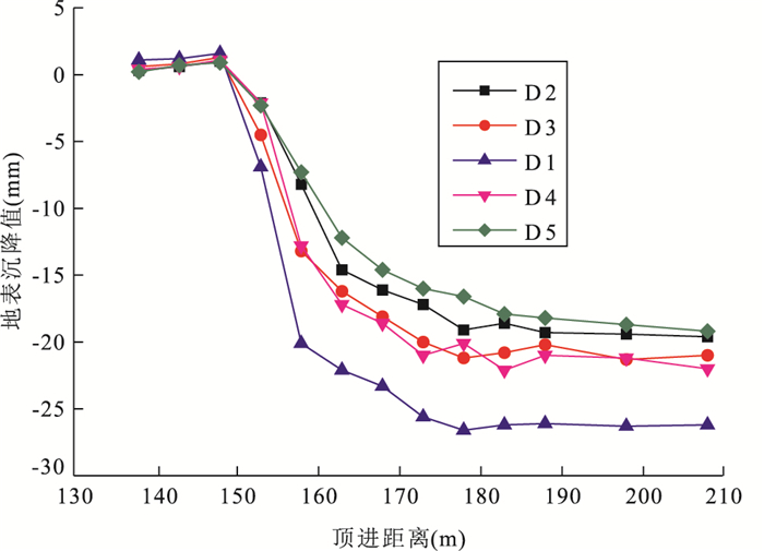
This paper discusses the engineering of a rectangulan pipe jacking project for the construction of the Shenzhuang Road-Shangding Road underpass in Zhengzhou.Roads inevitably deform excavation of a new large tunnel nearby in an urban underground engineering project. It is of great significanceto analyze the characteristics of ground surface deformation and their laws change to reduce the environmental impact of tunnel construction. Combined with the engineering practice of Zhengzhou Shen Zhuang Road-Shangding Road Underpass in Zhongzhou road tunnel engineering of rectangular pipe jacking.In-situ measured statistical analysis of ground surface deformation and the numerical simulation method of dynamic process of jacking pipe jacking construction analysis, it is found in this study the laws of the surface variation in the process of tunnel excavation.Numerical simulation can be applied to predict the influence of pipe jacking construction of existing road, to optimize the construction method and technical parameters, on basis of which the corresponding control measures can be put forward.The effectiveness of the forecast analysis has been verifiedthrough the engineering deformation monitoring data in this study.
This paper discusses the engineering of a rectangulan pipe jacking project for the construction of the Shenzhuang Road-Shangding Road underpass in Zhengzhou.Roads inevitably deform excavation of a new large tunnel nearby in an urban underground engineering project. It is of great significanceto analyze the characteristics of ground surface deformation and their laws change to reduce the environmental impact of tunnel construction. Combined with the engineering practice of Zhengzhou Shen Zhuang Road-Shangding Road Underpass in Zhongzhou road tunnel engineering of rectangular pipe jacking.In-situ measured statistical analysis of ground surface deformation and the numerical simulation method of dynamic process of jacking pipe jacking construction analysis, it is found in this study the laws of the surface variation in the process of tunnel excavation.Numerical simulation can be applied to predict the influence of pipe jacking construction of existing road, to optimize the construction method and technical parameters, on basis of which the corresponding control measures can be put forward.The effectiveness of the forecast analysis has been verifiedthrough the engineering deformation monitoring data in this study.


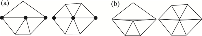
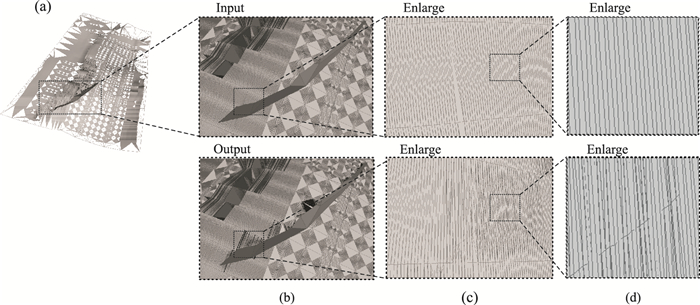
2016, 41(11): 1966-1976.
doi: 10.3799/dqkx.2016.137
Abstract:
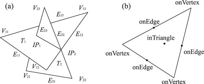
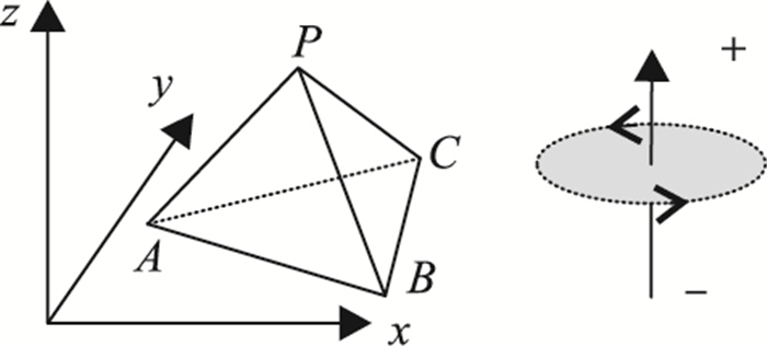
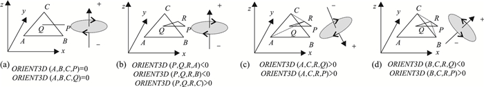
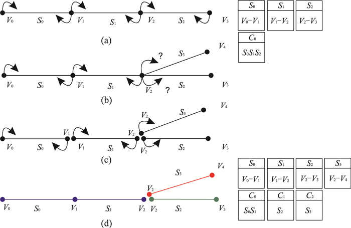
The complexity of 3D geological model and the singular spatial relationship among geological intersection objects greatly influenced the robustness and the reliability of intersection algorithm. An efficient and reliable intersection algorithm of complex geological model is proposed in this paper. Firstly, an intersection point topological structure is built to store the relative position between intersection point and adjacent elements. Then combining the exact predicates method, a complete edge/triangle intersection classification figure is designed which records 27 kinds of intersection cases and corresponding intersection point positions; in the process of re-triangulation, the designed adjustment mechanisms make full use of associated spatial relationship as the constraints, adding an additional level of reliability to the algorithm. The experimental results show that our algorithm efficiently handled the degenerate/self-intersection cases in triangular mesh and the tangency/co-planar/near co-planar triangles special cases in intersection process, and could provide a reference for 3D complex geological model intersection analysis.
The complexity of 3D geological model and the singular spatial relationship among geological intersection objects greatly influenced the robustness and the reliability of intersection algorithm. An efficient and reliable intersection algorithm of complex geological model is proposed in this paper. Firstly, an intersection point topological structure is built to store the relative position between intersection point and adjacent elements. Then combining the exact predicates method, a complete edge/triangle intersection classification figure is designed which records 27 kinds of intersection cases and corresponding intersection point positions; in the process of re-triangulation, the designed adjustment mechanisms make full use of associated spatial relationship as the constraints, adding an additional level of reliability to the algorithm. The experimental results show that our algorithm efficiently handled the degenerate/self-intersection cases in triangular mesh and the tangency/co-planar/near co-planar triangles special cases in intersection process, and could provide a reference for 3D complex geological model intersection analysis.