2016 Vol. 41, No. 12
Display Method:
 PDF 273KB
2016, 41(12): 1977-1994.
doi: 10.3799/dqkx.2016.138
Abstract:
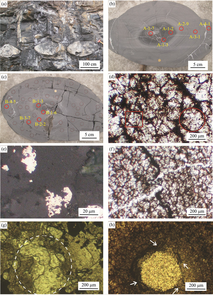
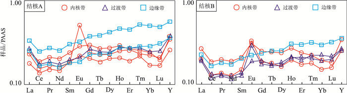
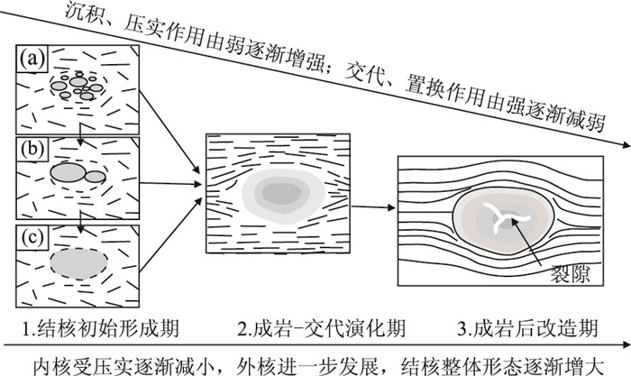
The carbonate nodules with strongly negative δ13C anomalies are widely developed in the black muddy shale in the forth member of the Doushantuo Formation from the Sinian System in the Zigui area, Yangtze Craton. Whether they were related to leakage of gas hydrate deserves further studies. Studies of sedimentary structure, petrography and geochemistry of these carbonate nodules show that these nodules have typical oscillatory zoning, sparry sphere structure, framboidal pyrite and agglomerate fabrics, which are related to venting system. The carbonate nodules display obvious negative δ13C anomalies (-5.65‰ to -6.76‰), strong enrichment of U and Mo elements (UEF=8-26, MoEF=99-320) and Y/Ho ratios between 31.05 and 37.31. Their REE distributions display gentle left-sloping patterns and their major and trace elements such as K, Sc, V, Cr, Co, Ni, Rb, Sr, Ba, Th, U and Mo indicate a hypoxia and sulfidic setting, which is consistent with characteristics and formation environment of cold seep carbonates. SiO2, MgO, CaO and CO2 contents of oscillatory zoning within the nodules show continuously increase or decrease changes, respectively. They reflect three stages of continuous evolution processes including primary formation, subsequent diagenesis-metasomatism and final diagenetic reworking. Accordingly, it can be proposed that these carbonate nodules were ultimately developed as decomposition, diagenesis and metasomatism of the low temperature stored solid gas hydrate sediment in the black muddy shale when the temperature became higher after the Neoproterozoic Gaskiers glaciation (582-551 Ma). This study provides an important record that confirms existence of the ancient natural gas hydrate and offers an important geological evidence for exploring shale gas (methane gas) reservoirs in the Sinian System and Lower Paleozoic sedimentary covers in the Yangtze Craton of South China.
The carbonate nodules with strongly negative δ13C anomalies are widely developed in the black muddy shale in the forth member of the Doushantuo Formation from the Sinian System in the Zigui area, Yangtze Craton. Whether they were related to leakage of gas hydrate deserves further studies. Studies of sedimentary structure, petrography and geochemistry of these carbonate nodules show that these nodules have typical oscillatory zoning, sparry sphere structure, framboidal pyrite and agglomerate fabrics, which are related to venting system. The carbonate nodules display obvious negative δ13C anomalies (-5.65‰ to -6.76‰), strong enrichment of U and Mo elements (UEF=8-26, MoEF=99-320) and Y/Ho ratios between 31.05 and 37.31. Their REE distributions display gentle left-sloping patterns and their major and trace elements such as K, Sc, V, Cr, Co, Ni, Rb, Sr, Ba, Th, U and Mo indicate a hypoxia and sulfidic setting, which is consistent with characteristics and formation environment of cold seep carbonates. SiO2, MgO, CaO and CO2 contents of oscillatory zoning within the nodules show continuously increase or decrease changes, respectively. They reflect three stages of continuous evolution processes including primary formation, subsequent diagenesis-metasomatism and final diagenetic reworking. Accordingly, it can be proposed that these carbonate nodules were ultimately developed as decomposition, diagenesis and metasomatism of the low temperature stored solid gas hydrate sediment in the black muddy shale when the temperature became higher after the Neoproterozoic Gaskiers glaciation (582-551 Ma). This study provides an important record that confirms existence of the ancient natural gas hydrate and offers an important geological evidence for exploring shale gas (methane gas) reservoirs in the Sinian System and Lower Paleozoic sedimentary covers in the Yangtze Craton of South China.


2016, 41(12): 1995-2007.
doi: 10.3799/dqkx.2016.139
Abstract:
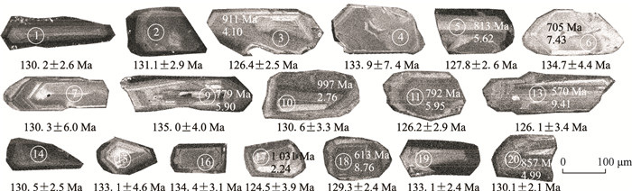
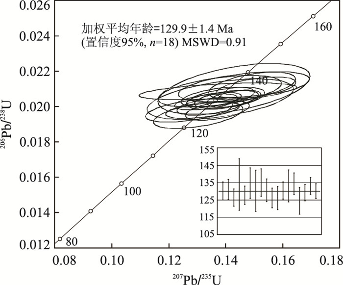
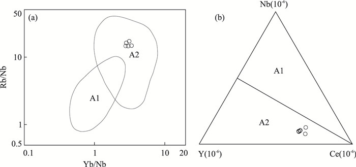
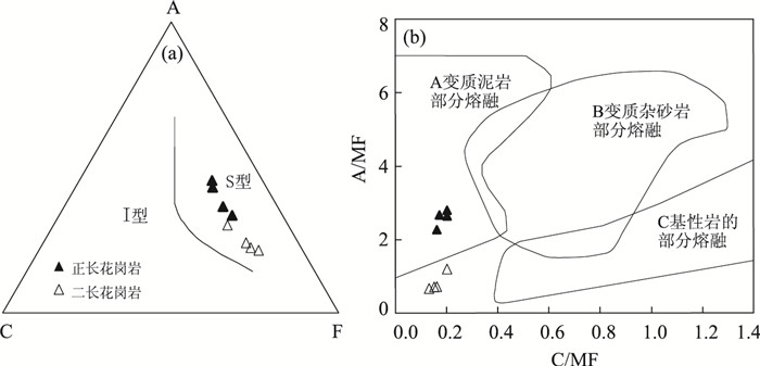
The tectonic setting of Da Hinggan Mountains area at the Late Mesozoic has always been controversial, this paper presents zircon U-Pb age, geochemistry and Hf isotopic data of Hudugeshaorong pluton in order to discuss its formation time and tectonic background. Hudugeshaorong pluton is mainly composed of porphyritic biotite monzogranite with LA-ICP-MS zircon U-Pb age of 129.9±1.4 Ma (MSWD=0.91), indicating it was intruded at the Early Cretaceous. This granite pluton is high in SiO2, Na2O, K2O and low in CaO, MgO, enriched in Rb, K, Th, U and Zr, and depleted in Ba, Sr, P and Ti. Rare earth elements show light REE enrichment (LREE/HREE=6.90-9.39) with obvious negative Eu anomalies (δEu=0.35-0.44), the ratio of 10 000×[w(Ga)/w(Al)] is between 2.08 and 3.05, showing that it is typical A-type granite. Hf isotopic analysis results show a positive εHf(t) values (2.24-9.41), two-stage model ages ranging from 1 030 Ma to 570 Ma, with an average age of 809 Ma. Combining with Th/U and Nb/Ta, we suggest that the primary magma was derived from the partial melting of the Neoproterozoic crust. Hudugeshaorong granite indicates that the study area was in an extensional environment during the Early Cretaceous, we suggest it is more likely related to the closure of the Mongol-Okhotsk Ocean.
The tectonic setting of Da Hinggan Mountains area at the Late Mesozoic has always been controversial, this paper presents zircon U-Pb age, geochemistry and Hf isotopic data of Hudugeshaorong pluton in order to discuss its formation time and tectonic background. Hudugeshaorong pluton is mainly composed of porphyritic biotite monzogranite with LA-ICP-MS zircon U-Pb age of 129.9±1.4 Ma (MSWD=0.91), indicating it was intruded at the Early Cretaceous. This granite pluton is high in SiO2, Na2O, K2O and low in CaO, MgO, enriched in Rb, K, Th, U and Zr, and depleted in Ba, Sr, P and Ti. Rare earth elements show light REE enrichment (LREE/HREE=6.90-9.39) with obvious negative Eu anomalies (δEu=0.35-0.44), the ratio of 10 000×[w(Ga)/w(Al)] is between 2.08 and 3.05, showing that it is typical A-type granite. Hf isotopic analysis results show a positive εHf(t) values (2.24-9.41), two-stage model ages ranging from 1 030 Ma to 570 Ma, with an average age of 809 Ma. Combining with Th/U and Nb/Ta, we suggest that the primary magma was derived from the partial melting of the Neoproterozoic crust. Hudugeshaorong granite indicates that the study area was in an extensional environment during the Early Cretaceous, we suggest it is more likely related to the closure of the Mongol-Okhotsk Ocean.


2016, 41(12): 2008-2018.
doi: 10.3799/dqkx.2016.140
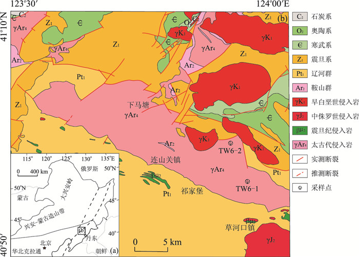
Abstract:
The fine chronology and geochemistry of the Lianshanguan granite complex in Benxi are scarce, and the Neoarchean magmatism in the Liaodong area is less and the study is relatively weak. The Lianshanguan area at Benxi in East Liaoning is the favorable metallogenic area for endogenous uranium deposits within uranium concentration area. Uranium deposits near the contact zone with the region mainly occur in Lianshanguan granitic complex and Langzishan Formation of Liaohe Group or Anshan Group, indicating close relationship between the rock and uranium mineralization. In Lianshanguan area, light flesh red syenogranite yields an SHRIMP U-Pb age of 2 512±14 Ma, white streak-shape monzonitic granite yields an SHRIMP U-Pb age of 2 510±15 Ma, and emplacement age of granitic complex is Neoarchean. Syenogranites show SiO2 of 69.28%-72.70%, K2O of 6.24%-7.12%, Na2O of 2.77%-3.09%, Al2O3 of 13.68%-15.92%. Monzonitic granites show SiO2 of 65.53%-71.01%, K2O of 2.95%-3.90%, Na2O of 3.57%-4.23%, Al2O3 of 14.13%-14.90%. Lianshanguan granitic complex contains muscovite and shows 1.09-1.16 (average 1.12) of A/CNK, 1.37-2.28 of corundum (C), no negative correlation between P2O5 and SiO2, so it is characterized by high potassium S-type granite. rare earth elements show higher content, strong fractional distillation between light and heavy rare earth elements, from positive to negative Eu anomaly (δEu=3.55-0.36), loss of Nb, Ta, P, Ti high field strength elements, enrichment of Rb, Th, K and other large-ion lithophile elements. The εHf(t) is -15.19 to -0.47, single-stage Hf model ages TDM are 2 826-3 400 Ma, and two-stage Hf model ages TDMC are 2 931-3 650 Ma. The Lianshanguan granitic complex in Liaodong area may be formed by deep-melting of Middle-Archean and Paleozoic crustal materials (mainly metamorphic mudstones and miscellaneous sandstones) under high-temperature and medium-pressure conditions, and may occur in the post-collision environment. It indicates that North China Craton micro-land collage was completed.
The fine chronology and geochemistry of the Lianshanguan granite complex in Benxi are scarce, and the Neoarchean magmatism in the Liaodong area is less and the study is relatively weak. The Lianshanguan area at Benxi in East Liaoning is the favorable metallogenic area for endogenous uranium deposits within uranium concentration area. Uranium deposits near the contact zone with the region mainly occur in Lianshanguan granitic complex and Langzishan Formation of Liaohe Group or Anshan Group, indicating close relationship between the rock and uranium mineralization. In Lianshanguan area, light flesh red syenogranite yields an SHRIMP U-Pb age of 2 512±14 Ma, white streak-shape monzonitic granite yields an SHRIMP U-Pb age of 2 510±15 Ma, and emplacement age of granitic complex is Neoarchean. Syenogranites show SiO2 of 69.28%-72.70%, K2O of 6.24%-7.12%, Na2O of 2.77%-3.09%, Al2O3 of 13.68%-15.92%. Monzonitic granites show SiO2 of 65.53%-71.01%, K2O of 2.95%-3.90%, Na2O of 3.57%-4.23%, Al2O3 of 14.13%-14.90%. Lianshanguan granitic complex contains muscovite and shows 1.09-1.16 (average 1.12) of A/CNK, 1.37-2.28 of corundum (C), no negative correlation between P2O5 and SiO2, so it is characterized by high potassium S-type granite. rare earth elements show higher content, strong fractional distillation between light and heavy rare earth elements, from positive to negative Eu anomaly (δEu=3.55-0.36), loss of Nb, Ta, P, Ti high field strength elements, enrichment of Rb, Th, K and other large-ion lithophile elements. The εHf(t) is -15.19 to -0.47, single-stage Hf model ages TDM are 2 826-3 400 Ma, and two-stage Hf model ages TDMC are 2 931-3 650 Ma. The Lianshanguan granitic complex in Liaodong area may be formed by deep-melting of Middle-Archean and Paleozoic crustal materials (mainly metamorphic mudstones and miscellaneous sandstones) under high-temperature and medium-pressure conditions, and may occur in the post-collision environment. It indicates that North China Craton micro-land collage was completed.


2016, 41(12): 2019-2030.
doi: 10.3799/dqkx.2016.141
Abstract:
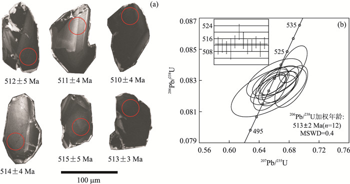
The Urad Zhongqi area of western Inner Mongolia crosses the North China Plate margin and Xing'an-Mongolia Orogenic Belt, which distributed regional basic rock massif occurred as small stocks, and a lack of reliable data of intrusion age. This paper reports LA-ICP-MS zircon U-Pb dating, geochemical and Hf isotopic data of Hadahushu mafic intrusion in Urad Zhongqi area, with the aim of constraining its petrogenesis and the beginning time of subduction of the Paleo-Asian oceanic plate. LA-ICP-MS U-Pb dating results of zircons from the mafic intrusion indicate that the intrusion formed at the Late Cambrian (513±2 Ma). The geochemical characteristics of these rocks indicate that they are the calc-alkaline series, and are characterized by enrichment in LILE (such as K, Ba, Rb), relatively depleted in HFSE (such as Nb, Ta, Zr, Ti) and LREE. The εHf(t) values and one-stage model ages (TDM1) of zircons from the rock vary from 14.15 to 15.03 and from 518 to 556 Ma, respectively. These characteristics suggest that the primary magma was derived from the depleted lithospheric mantle source. Based on the previous study, we conclude that the formation of mafic intrusion was related to the subduction of the Paleo-Asian oceanic plate.
The Urad Zhongqi area of western Inner Mongolia crosses the North China Plate margin and Xing'an-Mongolia Orogenic Belt, which distributed regional basic rock massif occurred as small stocks, and a lack of reliable data of intrusion age. This paper reports LA-ICP-MS zircon U-Pb dating, geochemical and Hf isotopic data of Hadahushu mafic intrusion in Urad Zhongqi area, with the aim of constraining its petrogenesis and the beginning time of subduction of the Paleo-Asian oceanic plate. LA-ICP-MS U-Pb dating results of zircons from the mafic intrusion indicate that the intrusion formed at the Late Cambrian (513±2 Ma). The geochemical characteristics of these rocks indicate that they are the calc-alkaline series, and are characterized by enrichment in LILE (such as K, Ba, Rb), relatively depleted in HFSE (such as Nb, Ta, Zr, Ti) and LREE. The εHf(t) values and one-stage model ages (TDM1) of zircons from the rock vary from 14.15 to 15.03 and from 518 to 556 Ma, respectively. These characteristics suggest that the primary magma was derived from the depleted lithospheric mantle source. Based on the previous study, we conclude that the formation of mafic intrusion was related to the subduction of the Paleo-Asian oceanic plate.


2016, 41(12): 2031-2040.
doi: 10.3799/dqkx.2016.142
Abstract:
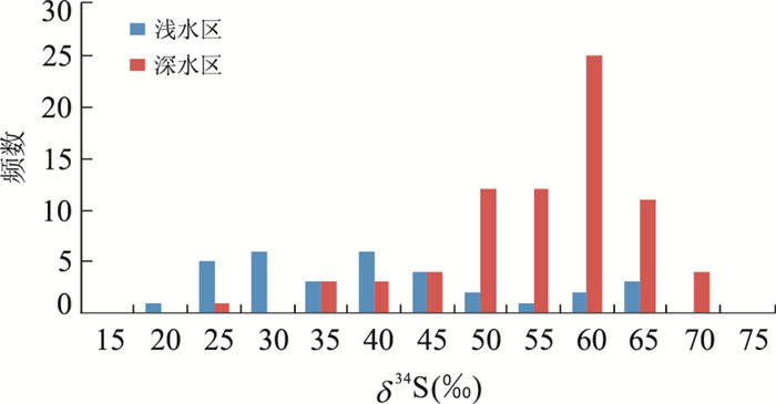
Songtao area, East Guizhou Province, is an important area rich in manganese ore deposit, of which there are relatively big differences between pyrite δ34S values. This paper focuses on the sulfur isotope composition of pyrite from dialogite samples in Lijiawan, Daotuo and Xixibao areas in Songtao. CF-IRSM results indicate two obvious characteristics: (1) the pyrites mostly have extremely high δ34S values, which vary between 47.69‰-66.76‰; (2) the δ34S values of pyrites in shallow water Lijiawan area (47.69‰-59.15‰) are obviously lower than those in deep water Daotuo area (53.85‰-62.86‰) in the same basin, and the δ34S values of pyrites in central facies (53.85‰-66.76‰) are obviously higher than those in transition facies (47.69‰-59.15‰), the sulfur isotope compositions of pyrites have distinctive depth gradient effect. The extremely high δ34S values and distinctive depth gradient features of pyrites in Mn deposit in Datangpo Formation indicate that the ocean has extremely low sulfate concentration and obvious stratified phenomenon. The deep ocean has not been completely oxidized at the beginning of interglacial period after Neoproterozoic sturtian glaciation.
Songtao area, East Guizhou Province, is an important area rich in manganese ore deposit, of which there are relatively big differences between pyrite δ34S values. This paper focuses on the sulfur isotope composition of pyrite from dialogite samples in Lijiawan, Daotuo and Xixibao areas in Songtao. CF-IRSM results indicate two obvious characteristics: (1) the pyrites mostly have extremely high δ34S values, which vary between 47.69‰-66.76‰; (2) the δ34S values of pyrites in shallow water Lijiawan area (47.69‰-59.15‰) are obviously lower than those in deep water Daotuo area (53.85‰-62.86‰) in the same basin, and the δ34S values of pyrites in central facies (53.85‰-66.76‰) are obviously higher than those in transition facies (47.69‰-59.15‰), the sulfur isotope compositions of pyrites have distinctive depth gradient effect. The extremely high δ34S values and distinctive depth gradient features of pyrites in Mn deposit in Datangpo Formation indicate that the ocean has extremely low sulfate concentration and obvious stratified phenomenon. The deep ocean has not been completely oxidized at the beginning of interglacial period after Neoproterozoic sturtian glaciation.


2016, 41(12): 2041-2060.
doi: 10.3799/dqkx.2016.528
Abstract:
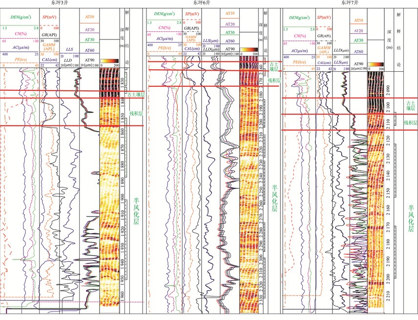
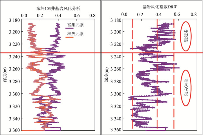
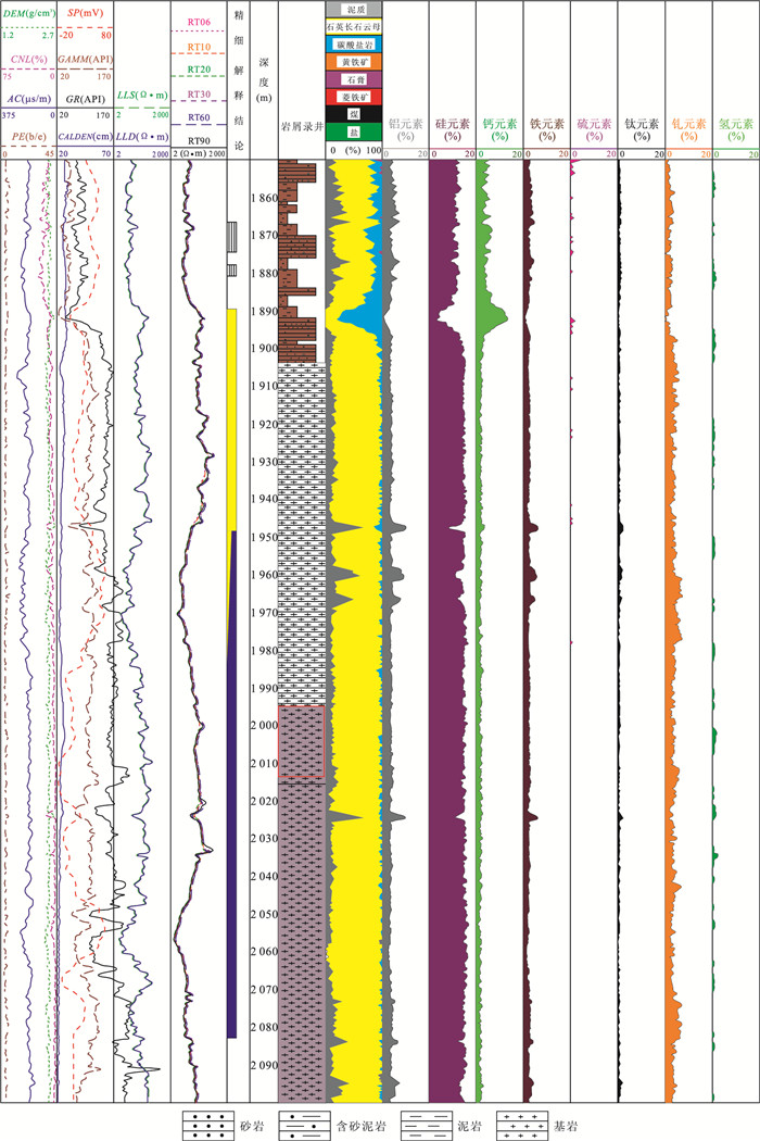
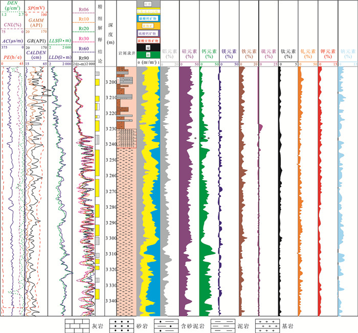
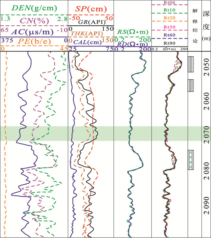
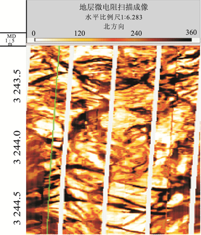
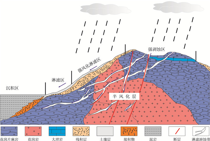
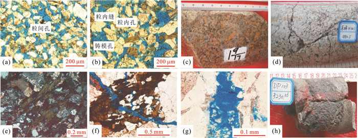
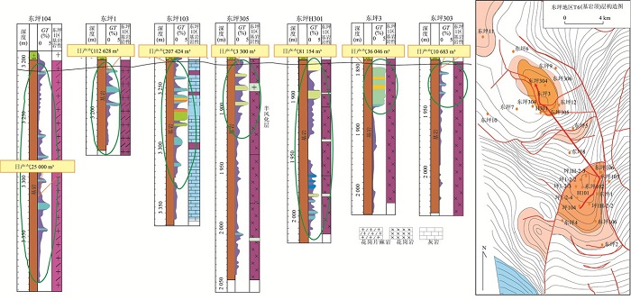
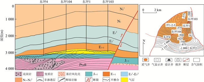
In recent years, many scholars have begun to pay attention to the basement reservoir, but there is no report about the study of weathering crust of basement. In this paper, structural characteristics of bedrock weathering crust and its relationship with oil and gas accumulate are systematically studied in Dongping area in the Qaidam Basin, combining with the geological data, logging and geochemical data. It is found that establishment of granitic bedrock weathering indexes based on Al2O3, CaO, Na2O, and K2O can ensure accurate identification of the ancient soil layer, elurium, semi-weathered layer, and unweathered layer. According to the imaging logging response characteristics and logging curves can well identify paleocrust characteristics, there are three types of tight reservoir space in weathering crusts of Dongping area: rock erosion holes, matrix mineral dissolved pores, and cracks in bedrock. Weathering crust on the base up gradually develops porosity, large semi-weathered rock porosity to the middle, and large pores mainly from semi-weathered rock to weathering exclusion soil, the pore size becomes smaller, and gradually to micro pore-based. In the longitudinal direction, porosity and degree of weathering and tectonic development, the burial depth and distance from the stress relief center have some relevance. The presence of weathering crust, greatly improves the reservoir properties, extends the bearing area, increases the gas-bearing system, which has important theoretical values and scientific significance to the granitic bedrock stratigraphic reservoirs and deep oil and gas exploration.
In recent years, many scholars have begun to pay attention to the basement reservoir, but there is no report about the study of weathering crust of basement. In this paper, structural characteristics of bedrock weathering crust and its relationship with oil and gas accumulate are systematically studied in Dongping area in the Qaidam Basin, combining with the geological data, logging and geochemical data. It is found that establishment of granitic bedrock weathering indexes based on Al2O3, CaO, Na2O, and K2O can ensure accurate identification of the ancient soil layer, elurium, semi-weathered layer, and unweathered layer. According to the imaging logging response characteristics and logging curves can well identify paleocrust characteristics, there are three types of tight reservoir space in weathering crusts of Dongping area: rock erosion holes, matrix mineral dissolved pores, and cracks in bedrock. Weathering crust on the base up gradually develops porosity, large semi-weathered rock porosity to the middle, and large pores mainly from semi-weathered rock to weathering exclusion soil, the pore size becomes smaller, and gradually to micro pore-based. In the longitudinal direction, porosity and degree of weathering and tectonic development, the burial depth and distance from the stress relief center have some relevance. The presence of weathering crust, greatly improves the reservoir properties, extends the bearing area, increases the gas-bearing system, which has important theoretical values and scientific significance to the granitic bedrock stratigraphic reservoirs and deep oil and gas exploration.


2016, 41(12): 2061-2074.
doi: 10.3799/dqkx.2016.143
Abstract:
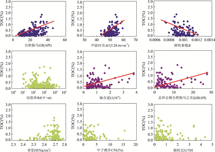
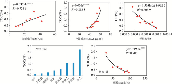
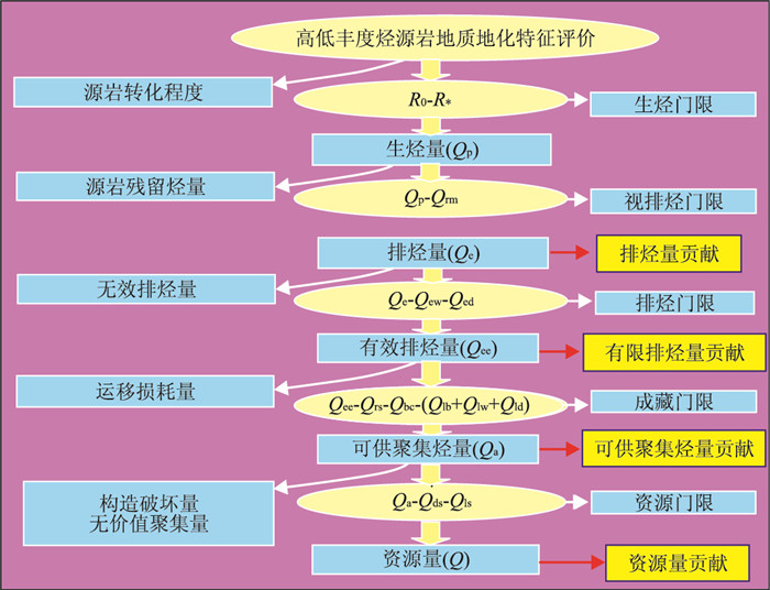
As oil and gas exploration is conducted in deep and super-deep layers, effectiveness and contribution to oil-gas accumulation of carbonate rocks with high thermal evolution and low organic matter abundance (TOC≤0.5%) in deep layer need to be reevaluated. This is a key scientific issue for oil and gas exploration in carbonate rocks in China. Taking Tazhong area as an example, a qualitative discriminating criterion for carbonate source rocks was established by determining the lower limit of TOC, analyzing logging response and influencing factors of organic matter abundance. Geochemical and geological characteristics of carbonate source rocks with low TOC (CSRLTOC) in Tazhong area were studied, and their contribution to oil-gas accumulation was evaluated by numerical simulation and hydrocarbon generation potential. Results show that the lower limit of TOC for effective carbonate source rocks with immature, mature, high mature and over mature stages are TOC=0.50%, TOC=0.30%, TOC=0.20% and TOC=0.15%, respectively. The log responses of carbonate source rocks have some differences from those for mudstone. The relationship of TOC, natural gamma, acoustic slowness and elastic parameter are better. The organic matter abundance is influenced by sedimentary environment, color of rock, and lithology. Based on above results, the discriminating criterion was established. In the Tazhong area, the CSRLTOC is less than none source rocks, with 24-500 m, accounting for 37% of the total thickness. The thickness of CSRLTOC is 1.54 to 5.92 times of those source rocks with high TOC (TOC > 5%).On the basis of the amounts of hydrocarbon expulsion, the amounts of effective hydrocarbon expulsion, the amounts of hydrocarbon accumulation and the amounts of oil-gas resources, the contributions of the CSRLTOC to oil-gas accumulation are 32.6%, 27.4%, 30.7% and 29.6%, respectively. Therefore, CSRLTOC should not be neglected in the theoretical research and resource evaluation.
As oil and gas exploration is conducted in deep and super-deep layers, effectiveness and contribution to oil-gas accumulation of carbonate rocks with high thermal evolution and low organic matter abundance (TOC≤0.5%) in deep layer need to be reevaluated. This is a key scientific issue for oil and gas exploration in carbonate rocks in China. Taking Tazhong area as an example, a qualitative discriminating criterion for carbonate source rocks was established by determining the lower limit of TOC, analyzing logging response and influencing factors of organic matter abundance. Geochemical and geological characteristics of carbonate source rocks with low TOC (CSRLTOC) in Tazhong area were studied, and their contribution to oil-gas accumulation was evaluated by numerical simulation and hydrocarbon generation potential. Results show that the lower limit of TOC for effective carbonate source rocks with immature, mature, high mature and over mature stages are TOC=0.50%, TOC=0.30%, TOC=0.20% and TOC=0.15%, respectively. The log responses of carbonate source rocks have some differences from those for mudstone. The relationship of TOC, natural gamma, acoustic slowness and elastic parameter are better. The organic matter abundance is influenced by sedimentary environment, color of rock, and lithology. Based on above results, the discriminating criterion was established. In the Tazhong area, the CSRLTOC is less than none source rocks, with 24-500 m, accounting for 37% of the total thickness. The thickness of CSRLTOC is 1.54 to 5.92 times of those source rocks with high TOC (TOC > 5%).On the basis of the amounts of hydrocarbon expulsion, the amounts of effective hydrocarbon expulsion, the amounts of hydrocarbon accumulation and the amounts of oil-gas resources, the contributions of the CSRLTOC to oil-gas accumulation are 32.6%, 27.4%, 30.7% and 29.6%, respectively. Therefore, CSRLTOC should not be neglected in the theoretical research and resource evaluation.


2016, 41(12): 2075-2087.
doi: 10.3799/dqkx.2016.144
Abstract:
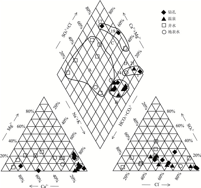
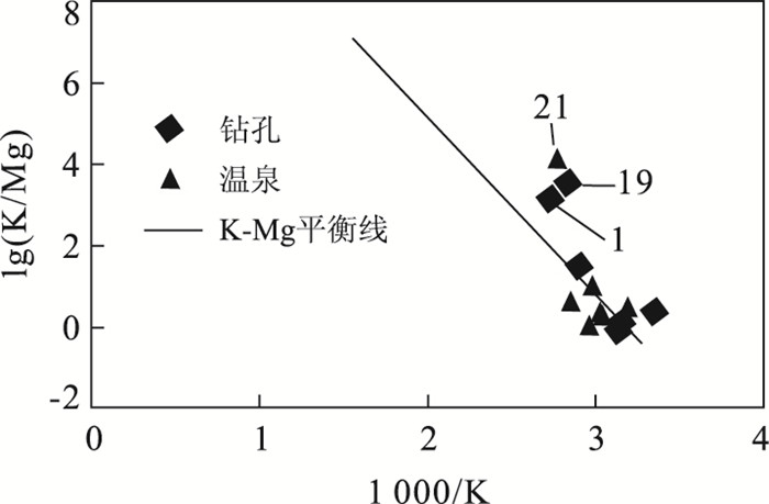
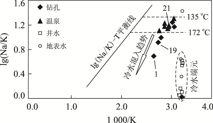
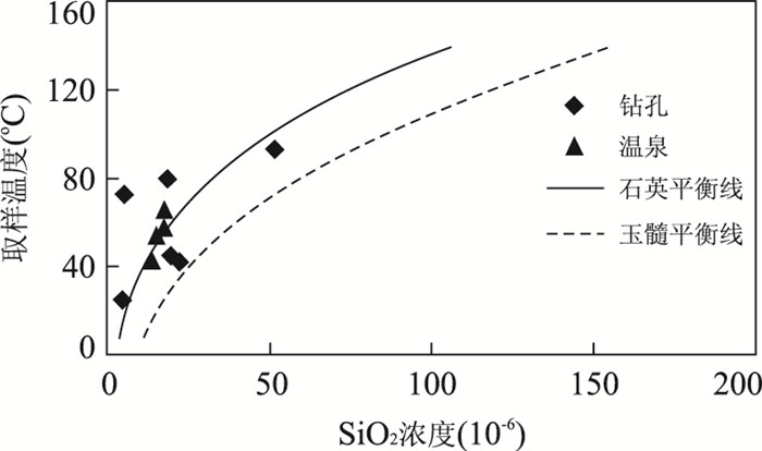
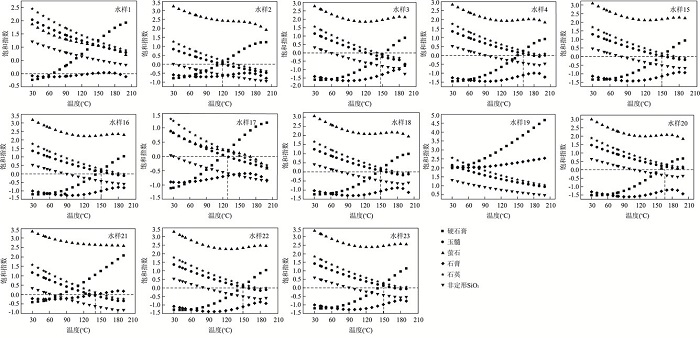
The estimated temperatures by traditional geochemical geothermometers and borehole temperatures are always different in practice. It is important to decide the equilibrium between minerals and fluids, determine the application of geothermometers for calculating heat exchanging temperatures, and choose the most suitable results. In this study, both Na-K-Mg triangular diagram and PHREEQCI code that simulate minerals saturation indexes were used to judge the equilibrium state between hot waters and minerals. The results show that: (1) the 23 water samples collected from the deep geothermal system in west coastal area of Guangdong Province are characterized by middle-low temperatures with weak alkalinity, high content of fluoride derived from the water-rock interaction between underground water and granite, and the transition of hydrochemical type from HCO3·Cl-Ca·Na to Cl-Na in groundwater from inland to coastal area; (2) Hydrochemical geothermometer temperature estimations show that the mixture of shallow water with deep water leads to the lower silica geothermometer temperatures than the actual ones. Only sample 21 with a subsurface equilibrium temperature at 150-170 ℃ can be calculated by cation geothermometers. K-Mg geothermometers yield minimum temperatures of heat exchange for samples 1 and 19 at 136.2 and 151.6 ℃, respectively. log(Q/K)-T plot proves better for other samples. The mixing (with cold water) process occurs when thermal waters ascend to the surface after a deep circle.
The estimated temperatures by traditional geochemical geothermometers and borehole temperatures are always different in practice. It is important to decide the equilibrium between minerals and fluids, determine the application of geothermometers for calculating heat exchanging temperatures, and choose the most suitable results. In this study, both Na-K-Mg triangular diagram and PHREEQCI code that simulate minerals saturation indexes were used to judge the equilibrium state between hot waters and minerals. The results show that: (1) the 23 water samples collected from the deep geothermal system in west coastal area of Guangdong Province are characterized by middle-low temperatures with weak alkalinity, high content of fluoride derived from the water-rock interaction between underground water and granite, and the transition of hydrochemical type from HCO3·Cl-Ca·Na to Cl-Na in groundwater from inland to coastal area; (2) Hydrochemical geothermometer temperature estimations show that the mixture of shallow water with deep water leads to the lower silica geothermometer temperatures than the actual ones. Only sample 21 with a subsurface equilibrium temperature at 150-170 ℃ can be calculated by cation geothermometers. K-Mg geothermometers yield minimum temperatures of heat exchange for samples 1 and 19 at 136.2 and 151.6 ℃, respectively. log(Q/K)-T plot proves better for other samples. The mixing (with cold water) process occurs when thermal waters ascend to the surface after a deep circle.


2016, 41(12): 2088-2099.
doi: 10.3799/dqkx.2016.514
Abstract:
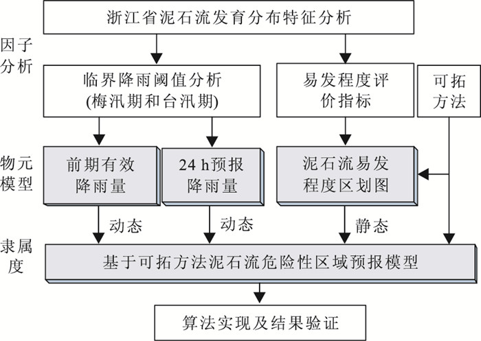
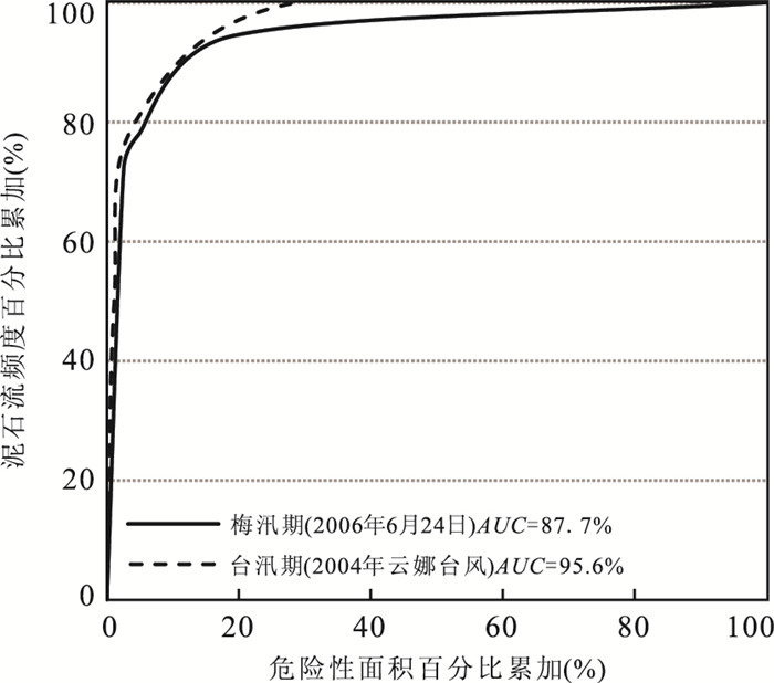
Debris flow is one of the major geohazards that may lead to mass injuries or casualties in Southeast China, however, studies on the development law and predictions need to be furthered. This study presents the characteristics of debris flow development and spatial-temporal distribution in Zhejiang Province based on the results of small drainage geohazards survey. It is found that the debris flows mainly occur in Meiyu period (i.e. 27.4%) and typhoon season (i.e. 70.1%). Generally, the debris flows in typhoon season are mostly distributed in southeast Zhejiang, whereas those in Meiyu period are distributed in west. Based on that, rainfall thresholds of different raining seasons have been determined. Separate forecasting models based on extension method have been established taking small drainage as assessment unit, where the susceptibility map, 24-hour forecast rainfall and effective antecedent precipitation are employed as model inputs. Two debris flows, occurred in Yunna typhoon period in 2004 and in Meiyu period in June, 2006, were selected to validate the established forecasting models. The results in terms of hazard intensity (R) and receiver operating characteristiccurve (ROC) confirm the feasibility of the proposed scheme for debris flow forecasting.
Debris flow is one of the major geohazards that may lead to mass injuries or casualties in Southeast China, however, studies on the development law and predictions need to be furthered. This study presents the characteristics of debris flow development and spatial-temporal distribution in Zhejiang Province based on the results of small drainage geohazards survey. It is found that the debris flows mainly occur in Meiyu period (i.e. 27.4%) and typhoon season (i.e. 70.1%). Generally, the debris flows in typhoon season are mostly distributed in southeast Zhejiang, whereas those in Meiyu period are distributed in west. Based on that, rainfall thresholds of different raining seasons have been determined. Separate forecasting models based on extension method have been established taking small drainage as assessment unit, where the susceptibility map, 24-hour forecast rainfall and effective antecedent precipitation are employed as model inputs. Two debris flows, occurred in Yunna typhoon period in 2004 and in Meiyu period in June, 2006, were selected to validate the established forecasting models. The results in terms of hazard intensity (R) and receiver operating characteristiccurve (ROC) confirm the feasibility of the proposed scheme for debris flow forecasting.


2016, 41(12): 2100-2108.
doi: 10.3799/dqkx.2016.145
Abstract:
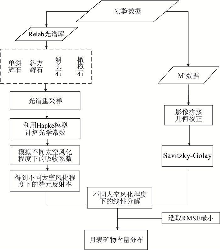
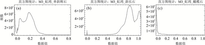
The inversion of lunar minerals is critical to study the Moon's geological origin and evolution. Space weathering generally occurs on the surface of the Moon with an assignable influence on the pure mineral spectra, which obscures the reflectance spectra feature of minerals and reduces the overall reflectance. The effect of space weathering should be removed when accurately investigating the lunar minerals using remote sensing technology. The level of the space weathering is proportional to the mass fraction of submicroscopic metallic iron (SMFe). In this paper, the authors firstly transform the bidirectional reflectance into the isotropic single scattering albedo of four endmember minerals (clinopyroxene, orthopyroxene, plagioclase and olivine) in the Relab spectral library based on Hapke radiative transfer model, secondly, calculate the optical constants and absorption coefficient of each mineral, then simulate the reflectance spectra of these minerals under six space weathering levels according to SMFe mass fraction, thus we obtain endmember mineral reflectance under different space weathering levels. Finally we inverse mineral abundance with six multi-endmember linear unmixing models and the M3 (moon mineralogy mapper) hyperspectral data and obtain the inversion abundance and distribution of pyroxene, plagioclase and olivine in Lunar Sinus Iridum. The results show that using multi-endmember linear unmixing method can effectively simulate the effects of space weathering on mineral spectra, and it is an useful way of mineral identification and abundance inversion with hyperspectral under the space weathering.
The inversion of lunar minerals is critical to study the Moon's geological origin and evolution. Space weathering generally occurs on the surface of the Moon with an assignable influence on the pure mineral spectra, which obscures the reflectance spectra feature of minerals and reduces the overall reflectance. The effect of space weathering should be removed when accurately investigating the lunar minerals using remote sensing technology. The level of the space weathering is proportional to the mass fraction of submicroscopic metallic iron (SMFe). In this paper, the authors firstly transform the bidirectional reflectance into the isotropic single scattering albedo of four endmember minerals (clinopyroxene, orthopyroxene, plagioclase and olivine) in the Relab spectral library based on Hapke radiative transfer model, secondly, calculate the optical constants and absorption coefficient of each mineral, then simulate the reflectance spectra of these minerals under six space weathering levels according to SMFe mass fraction, thus we obtain endmember mineral reflectance under different space weathering levels. Finally we inverse mineral abundance with six multi-endmember linear unmixing models and the M3 (moon mineralogy mapper) hyperspectral data and obtain the inversion abundance and distribution of pyroxene, plagioclase and olivine in Lunar Sinus Iridum. The results show that using multi-endmember linear unmixing method can effectively simulate the effects of space weathering on mineral spectra, and it is an useful way of mineral identification and abundance inversion with hyperspectral under the space weathering.


2016, 41(12): 2109-2117.
doi: 10.3799/dqkx.2016.146
Abstract:
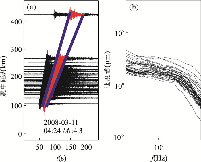
North China basin is one of the active seismic regions in the mainland of China. Studies of Lg wave attenuation and site responses can be used for tectonic interpretation, seismic hazard assessment and earthquake prediction. A combined inversion method based on seismic spectral ratios is an effective method for estimating attenuation and site responses. In this paper, a random resampling method is used to check stability of the solutions. Over 1 000 vertical seismograms with signal-to-noise ratio greater than two from 149 events were analyzed. The seismograms are recorded in the distance range of 100-600 km, the earthquakes occurred between 2004 and 2008 in the region and varied in magnitude between 1.7 and 5.3 (ML).The ray-paths cover the region ranging from 38°N to 41°N and 114°E to 120°E.Fourier spectral amplitudes are measured from Lg phases windowed between the group velocity limits 2.60 and 3.65 km/s. The inversion is performed in a frequency range of 1-7 Hz with an interval of 0.2 Hz. The region displays low Q0 and a strong frequency dependence characterized by function Q=125±4.4f0.86±0.03. The result is consistent with the geology of the active tectonic region. The rock sites show small amplification. For soil sites, the amplification of low-frequency waves is higher than that for high-frequency waves. For the stations with more amplification, the corresponding error bar is great. This may indicate that the instability of the bases of these stations reduces the stability of the solution.
North China basin is one of the active seismic regions in the mainland of China. Studies of Lg wave attenuation and site responses can be used for tectonic interpretation, seismic hazard assessment and earthquake prediction. A combined inversion method based on seismic spectral ratios is an effective method for estimating attenuation and site responses. In this paper, a random resampling method is used to check stability of the solutions. Over 1 000 vertical seismograms with signal-to-noise ratio greater than two from 149 events were analyzed. The seismograms are recorded in the distance range of 100-600 km, the earthquakes occurred between 2004 and 2008 in the region and varied in magnitude between 1.7 and 5.3 (ML).The ray-paths cover the region ranging from 38°N to 41°N and 114°E to 120°E.Fourier spectral amplitudes are measured from Lg phases windowed between the group velocity limits 2.60 and 3.65 km/s. The inversion is performed in a frequency range of 1-7 Hz with an interval of 0.2 Hz. The region displays low Q0 and a strong frequency dependence characterized by function Q=125±4.4f0.86±0.03. The result is consistent with the geology of the active tectonic region. The rock sites show small amplification. For soil sites, the amplification of low-frequency waves is higher than that for high-frequency waves. For the stations with more amplification, the corresponding error bar is great. This may indicate that the instability of the bases of these stations reduces the stability of the solution.


2016, 41(12): 2119-2126.
doi: 10.3799/dqkx.2016.147
Abstract:
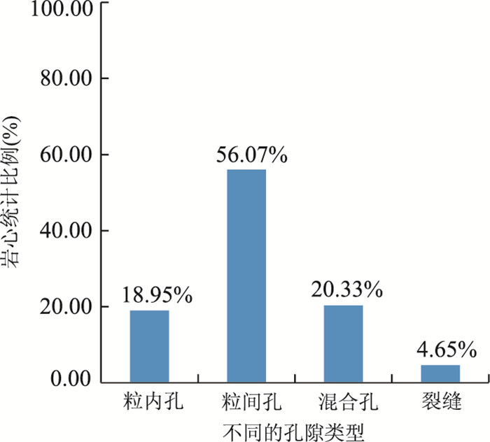
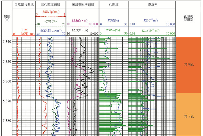
There is no strict general mathematical relationship between the porosity and permeability of the carbonate reservoir in Changxing Formation and Feixianguan Formation in Puguang area, which results in difficulty of reservoir permeability calculation. In this study, we establish a model to solve this issue. By the analysis of the logging data, conventional slices, casting slices and core physical properties in this area, it is found that the carbonate rock pore type is the main factor influencing the porosity and permeability relationship. Based on the conventional logging data, the more sensitive logging characteristics of pore structure are constructed: AC/DEN (the ratio of acoustic transit-time and density) and LLD/LLS (the ratio of deep lateral resistivity and shallow lateral resistivity) are used to identify the carbonate pore types; then the poroperm relationship model is established according to different pore types to calculate the reservoir permeability in this area.The site data processing results show that the model calculated permeability is in good agreement with the core analysis permeability, also the law among wells is consistent, and the reservoir porosity and permeability model that based on the pore structure can well determine the reservoir permeability.
There is no strict general mathematical relationship between the porosity and permeability of the carbonate reservoir in Changxing Formation and Feixianguan Formation in Puguang area, which results in difficulty of reservoir permeability calculation. In this study, we establish a model to solve this issue. By the analysis of the logging data, conventional slices, casting slices and core physical properties in this area, it is found that the carbonate rock pore type is the main factor influencing the porosity and permeability relationship. Based on the conventional logging data, the more sensitive logging characteristics of pore structure are constructed: AC/DEN (the ratio of acoustic transit-time and density) and LLD/LLS (the ratio of deep lateral resistivity and shallow lateral resistivity) are used to identify the carbonate pore types; then the poroperm relationship model is established according to different pore types to calculate the reservoir permeability in this area.The site data processing results show that the model calculated permeability is in good agreement with the core analysis permeability, also the law among wells is consistent, and the reservoir porosity and permeability model that based on the pore structure can well determine the reservoir permeability.


2016, 41(12): 2127-2135.
doi: 10.3799/dqkx.2016.148
Abstract:
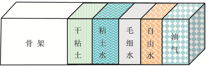
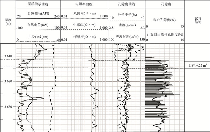
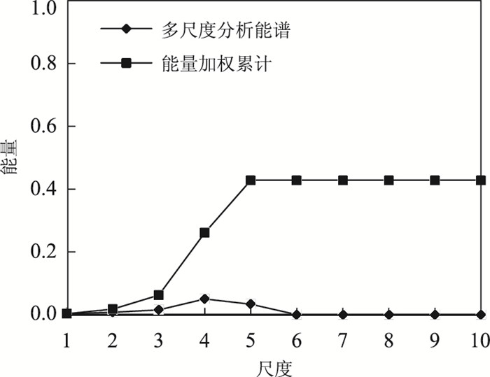
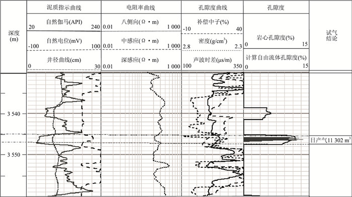
With the characteristics such as low porosity, low permeability, strong heterogeneity, tight sandstone, and complexlogging response of tight sandstone reservoirs, the gas identification and evaluation are difficult with multiple solutions. The peak energy and a weighted cumulative quantitative are applied in the paper to analyze features of multi-scale wavelet and wavelet packet analysis based on three-water model, cores, geological and gas test data in tight sandstone gas reservoirs. Then the appropriate method of multi-scale wavelet energy spectrum of tight sandstone gas reservoirsis selected to identify tight sandstone gas in Sulige region, which achieved good effect.
With the characteristics such as low porosity, low permeability, strong heterogeneity, tight sandstone, and complexlogging response of tight sandstone reservoirs, the gas identification and evaluation are difficult with multiple solutions. The peak energy and a weighted cumulative quantitative are applied in the paper to analyze features of multi-scale wavelet and wavelet packet analysis based on three-water model, cores, geological and gas test data in tight sandstone gas reservoirs. Then the appropriate method of multi-scale wavelet energy spectrum of tight sandstone gas reservoirsis selected to identify tight sandstone gas in Sulige region, which achieved good effect.


2016, 41(12): 2136-2146.
doi: 10.3799/dqkx.2016.149
Abstract:
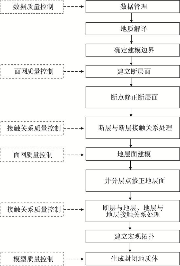
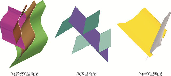
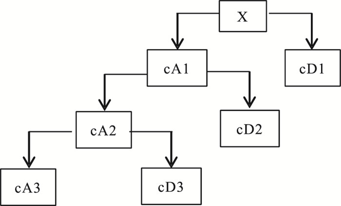
Three dimensional structural modeling is the core content of the 3-D geological modeling, which mainly reveals the geometry and topology of geological structure. The increasing importance of 3-D structural modeling technique in all geological fields induces higher requirements, that is, the modeling should be capable of addressing more complex geological conditions, allowing for more precise characterization of geological structures. This paper starts with the demand of 3-D structural modeling in actual geological application, explains three essential elements systematically, puts forward geological criteria and geospatial data model, and hence improves the modeling theory. Difficulties and key technology associated with 3-D structural modeling are discussed, the future development trend and direction are predicted through analysis of advantages and disadvantages of various modeling methods used by modern 3-D structural modeling.
Three dimensional structural modeling is the core content of the 3-D geological modeling, which mainly reveals the geometry and topology of geological structure. The increasing importance of 3-D structural modeling technique in all geological fields induces higher requirements, that is, the modeling should be capable of addressing more complex geological conditions, allowing for more precise characterization of geological structures. This paper starts with the demand of 3-D structural modeling in actual geological application, explains three essential elements systematically, puts forward geological criteria and geospatial data model, and hence improves the modeling theory. Difficulties and key technology associated with 3-D structural modeling are discussed, the future development trend and direction are predicted through analysis of advantages and disadvantages of various modeling methods used by modern 3-D structural modeling.