2016 Vol. 41, No. 2
column
Display Method:
 PDF 236KB
2016, 41(2): 177-188.
doi: 10.3799/dqkx.2016.014
Abstract:
The "Datangpo type" manganese deposits in Guizhou-Hunan-Chongqing border area is an important manganese resource base since its hundreds of million tons of sedimentary rhodochrosite accounts for about half of manganese resource of China. In this paper, based on the study about the formation system of Nanhua period and stratigraphic regionalization, we find under the background of Rodinia supercontinent breakup, the Nanhua rift basin (level I) consisted of the Wuling and Xuefeng secondary rift basin and the Tianzhu-Huaihua uplift. Wuling secondary rift basin controlled and formed the manganese metallogenic area in the Guizhou-Hunan-Chongqing border area, and its inside consisted of three level Ⅲ depression basins, one level Ⅲ uplift and sixteen level IV rift basins. The three level Ⅲ depression basins controlled Songtao-Guzhang, Yiping-Zhijiang and Xikou-Xiaochayuan secondary manganese metallogenic area. Among them, the Songtao-Guzhang depression basin (Level Ⅲ) is the rifting center of the Wuling secondary rift basin, where the manganese mineralization is strong, and the quantity of resource is huge, which has became a world-level manganese concentrated area. The IV rift basins controlled and formed the manganese deposits in the target area. It's suggested that the syn-sedimentary fault in Nanhua period is the premise of manganese deposit formation, fifteen syn-sedimentary faults, the controlled depression basins and the major manganese in the target area are distinguished and recovered. The syn-sedimentary fault is not only the transporting tunnel of deep manganese material and ancient natural gas but also the link of inside system and surface system of ancient natural gas seepage sedimentary-type manganese metallogenic system.
The "Datangpo type" manganese deposits in Guizhou-Hunan-Chongqing border area is an important manganese resource base since its hundreds of million tons of sedimentary rhodochrosite accounts for about half of manganese resource of China. In this paper, based on the study about the formation system of Nanhua period and stratigraphic regionalization, we find under the background of Rodinia supercontinent breakup, the Nanhua rift basin (level I) consisted of the Wuling and Xuefeng secondary rift basin and the Tianzhu-Huaihua uplift. Wuling secondary rift basin controlled and formed the manganese metallogenic area in the Guizhou-Hunan-Chongqing border area, and its inside consisted of three level Ⅲ depression basins, one level Ⅲ uplift and sixteen level IV rift basins. The three level Ⅲ depression basins controlled Songtao-Guzhang, Yiping-Zhijiang and Xikou-Xiaochayuan secondary manganese metallogenic area. Among them, the Songtao-Guzhang depression basin (Level Ⅲ) is the rifting center of the Wuling secondary rift basin, where the manganese mineralization is strong, and the quantity of resource is huge, which has became a world-level manganese concentrated area. The IV rift basins controlled and formed the manganese deposits in the target area. It's suggested that the syn-sedimentary fault in Nanhua period is the premise of manganese deposit formation, fifteen syn-sedimentary faults, the controlled depression basins and the major manganese in the target area are distinguished and recovered. The syn-sedimentary fault is not only the transporting tunnel of deep manganese material and ancient natural gas but also the link of inside system and surface system of ancient natural gas seepage sedimentary-type manganese metallogenic system.


2016, 41(2): 189-198.
doi: 10.3799/dqkx.2016.015
Abstract:
Shuangwang gold deposit is one of the largest crisis mines in Qinling area with special genetic type, and it is urgent for us to undertake prospecting. But different scholars have some controversy over the evolution of the metallogenic tectonic as well as over the ore-controlling mechanism in this deposit. This paper studies the relationship of spatial distribution among the breccia bodies, fractures and fissures, and gold grade taking KT5 ore body in the deposit for an example. The regularity of gold enrichment and its implications to metallogenic tectonics are discussed, combined with trend surface analysis. According to mineralization characteristics and the age of the mafic dyke swarms in the mine area, it is suggested that the ore-forming process happened mainly in Indosinian. Under the compressive stress from north to south during Indosinian orogenesis in Qinling area, two sides of the metallogenic fault sheared obliquely with rightward contortion in the early stage, which formed the rudiment of breccia belt. In the intermediate stage, earthquake and associated hydraulic fracturing, which were induced along with the fault movement, produced the main breccia bodies together with fractures and fissures; in the gold mineragenetic process, the brecciation trailed off, while the fractures and fissures developed continuously, and they played important roles of the main pathway as well as advantaged ore-forming space for metallogenic fluid, so the gold enrichment revealed planar distribution, and the change of the fractures and fissures occurrence was the basic factor that resulted in Au precipitation. In the late stage, the extension changed to east-west, and the mafic dyke swarms intruded in the setting, which were altered by metallogenic fluid.
Shuangwang gold deposit is one of the largest crisis mines in Qinling area with special genetic type, and it is urgent for us to undertake prospecting. But different scholars have some controversy over the evolution of the metallogenic tectonic as well as over the ore-controlling mechanism in this deposit. This paper studies the relationship of spatial distribution among the breccia bodies, fractures and fissures, and gold grade taking KT5 ore body in the deposit for an example. The regularity of gold enrichment and its implications to metallogenic tectonics are discussed, combined with trend surface analysis. According to mineralization characteristics and the age of the mafic dyke swarms in the mine area, it is suggested that the ore-forming process happened mainly in Indosinian. Under the compressive stress from north to south during Indosinian orogenesis in Qinling area, two sides of the metallogenic fault sheared obliquely with rightward contortion in the early stage, which formed the rudiment of breccia belt. In the intermediate stage, earthquake and associated hydraulic fracturing, which were induced along with the fault movement, produced the main breccia bodies together with fractures and fissures; in the gold mineragenetic process, the brecciation trailed off, while the fractures and fissures developed continuously, and they played important roles of the main pathway as well as advantaged ore-forming space for metallogenic fluid, so the gold enrichment revealed planar distribution, and the change of the fractures and fissures occurrence was the basic factor that resulted in Au precipitation. In the late stage, the extension changed to east-west, and the mafic dyke swarms intruded in the setting, which were altered by metallogenic fluid.


2016, 41(2): 199-217.
doi: 10.3799/dqkx.2016.016
Abstract:
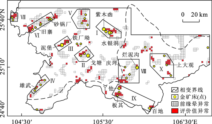
The study of the denudation degree of the Carlin-type gold deposits (ore fields-ore deposits-ore occurrences) in southwest Guizhou Province could facilitate future exploration. Present research is based on hydrothermal halo zoning percolation theory, the general unbiased feature of the space between gold deposits and secondary anomalies as well as the mineralization zoning of the ore-forming elements. The sequence of element zoning which could reflect the common features of ore-forming elements dispersed flow and primary halos in regional scale dimension is firstly constructed.Then, the contrast values of geochemical strength between the front and rear halo in zoning sequence are obtained on the basis of singularity analysis of stream sediment geochemical dataset collected in this region. The evaluating indicators of denudation degree are established and classified into four different levels as low-light-medium-high according to the data structures of contrast values.In addition, the evaluating indicators are applied to comprehensive evaluation combined with the geological characteristics of deposits, ore fields and their surroundings. In this paper, the results of denudation degree related to the ten ore fields and fifteen major gold deposits are presented. Our research reveals that the Youjiang ore fields have lower degree of denudation than the Yangtze one. Furthermore, the degree of denudation is apparently positively correlated with the amount of resources.The medium to superlarge sized gold deposits such as Nibao deposit, Zimudang deposit, Shuiyindong deposit, Yata deposit and Lannigou deposit are characterized with the low-to light-denudation degree.While the relatively small sized deposits such as Banqi deposit, Getang deposit, Laowanchang deposit are with the high degree of denudation. The evaluation results are consistent with those of the previous exploration work and may be extended to the areas undergone basic prospection.In addition, it is found that the anomalies of the contrast value are the main sign of the evaluation for obtaining prospecting breakthrough and deep area ore-prospecting of existing deposits. Fourteen districts of deep ore with high prospecting potential are proposed in this study, including the Shuiyindong deposits and its eastern deep area, the contact zone between Permian and Triassic strata in the northwestern part of Getang deposit and the deep part of the Shangdaguan ore occurrence.
The study of the denudation degree of the Carlin-type gold deposits (ore fields-ore deposits-ore occurrences) in southwest Guizhou Province could facilitate future exploration. Present research is based on hydrothermal halo zoning percolation theory, the general unbiased feature of the space between gold deposits and secondary anomalies as well as the mineralization zoning of the ore-forming elements. The sequence of element zoning which could reflect the common features of ore-forming elements dispersed flow and primary halos in regional scale dimension is firstly constructed.Then, the contrast values of geochemical strength between the front and rear halo in zoning sequence are obtained on the basis of singularity analysis of stream sediment geochemical dataset collected in this region. The evaluating indicators of denudation degree are established and classified into four different levels as low-light-medium-high according to the data structures of contrast values.In addition, the evaluating indicators are applied to comprehensive evaluation combined with the geological characteristics of deposits, ore fields and their surroundings. In this paper, the results of denudation degree related to the ten ore fields and fifteen major gold deposits are presented. Our research reveals that the Youjiang ore fields have lower degree of denudation than the Yangtze one. Furthermore, the degree of denudation is apparently positively correlated with the amount of resources.The medium to superlarge sized gold deposits such as Nibao deposit, Zimudang deposit, Shuiyindong deposit, Yata deposit and Lannigou deposit are characterized with the low-to light-denudation degree.While the relatively small sized deposits such as Banqi deposit, Getang deposit, Laowanchang deposit are with the high degree of denudation. The evaluation results are consistent with those of the previous exploration work and may be extended to the areas undergone basic prospection.In addition, it is found that the anomalies of the contrast value are the main sign of the evaluation for obtaining prospecting breakthrough and deep area ore-prospecting of existing deposits. Fourteen districts of deep ore with high prospecting potential are proposed in this study, including the Shuiyindong deposits and its eastern deep area, the contact zone between Permian and Triassic strata in the northwestern part of Getang deposit and the deep part of the Shangdaguan ore occurrence.


2016, 41(2): 218-233.
doi: 10.3799/dqkx.2016.017
Abstract:
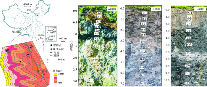
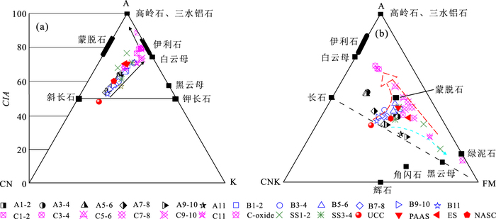
Black shales are special sedimentary rocks that contain significant amounts of organic matter and sulfide minerals; whereas, less is known about the elemental mobility and weathering mechanism in black shales during chemical weathering. For understanding the chemical weathering processes of black shale in different geographic locations, a number of Shuijingtuo Formation black shale samples were collected from three weathering profiles, namely, profile A (mid-ridge), profile B (near mountaintop), and profile C (valley) at Chengkou County, northeastern Chongqing Province in this study. The major element concentration, mineral composition, and bulk density of each sample were analyzed by XRF, XRD and chemical analysis methods. The results of geochemical analysis indicate that these weathering profiles were significantly depleted of Ca, Mg and Na in all samples but enriched in Al on the surface weathering zone by calculated mass transfer coefficient (τ) and mass transfer flux (Mj, flux) in all samples. From the perspective of mineralogy, the calcite, dolomite and plagioclase were dissolved in acid solution produced from pyrite and organic matter, and the illite, gypsum and Fe-oxides were formed during chemical weathering process. From the graphical representations of Na/K-CIA, K/Ca*-Al/Na, A-CN-K, and A-CNK-FM show that profile A is located in the weak chemical weathering stage of Ca removal. Profile B has reached the weak to moderate chemical weathering stage and being initial stage of Ca and Na removal. Profile C has undergone the early stage of Ca and Na removal, and reached the Si removal (desilication) stage of moderate to strong chemical weathering. Different chemical weathering indexes of CIA, CIW, PIA, and MWPI were calculated in three profiles, showing that the chemical weathering sequence in all profiles is C > B > A.
Black shales are special sedimentary rocks that contain significant amounts of organic matter and sulfide minerals; whereas, less is known about the elemental mobility and weathering mechanism in black shales during chemical weathering. For understanding the chemical weathering processes of black shale in different geographic locations, a number of Shuijingtuo Formation black shale samples were collected from three weathering profiles, namely, profile A (mid-ridge), profile B (near mountaintop), and profile C (valley) at Chengkou County, northeastern Chongqing Province in this study. The major element concentration, mineral composition, and bulk density of each sample were analyzed by XRF, XRD and chemical analysis methods. The results of geochemical analysis indicate that these weathering profiles were significantly depleted of Ca, Mg and Na in all samples but enriched in Al on the surface weathering zone by calculated mass transfer coefficient (τ) and mass transfer flux (Mj, flux) in all samples. From the perspective of mineralogy, the calcite, dolomite and plagioclase were dissolved in acid solution produced from pyrite and organic matter, and the illite, gypsum and Fe-oxides were formed during chemical weathering process. From the graphical representations of Na/K-CIA, K/Ca*-Al/Na, A-CN-K, and A-CNK-FM show that profile A is located in the weak chemical weathering stage of Ca removal. Profile B has reached the weak to moderate chemical weathering stage and being initial stage of Ca and Na removal. Profile C has undergone the early stage of Ca and Na removal, and reached the Si removal (desilication) stage of moderate to strong chemical weathering. Different chemical weathering indexes of CIA, CIW, PIA, and MWPI were calculated in three profiles, showing that the chemical weathering sequence in all profiles is C > B > A.


2016, 41(2): 234-251.
doi: 10.3799/dqkx.2016.018
Abstract:
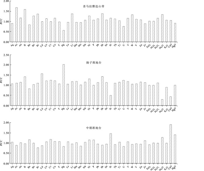
Large amounts of high quality basic geochemical data covering a land area of about 6 900 000 square kilometers have been gained by regional geochemical survey mainly featuring stream sediment measurement since 1978 in China. The development and utilization of the comparative data in different areas and different ranges is an important part of the research of dispersion of element enrichment, metallogenic tendency, and anomaly evaluation. Based on the total original data of the national 1:200 000 stream sediment survey, background values of 39 elements in stream sediments are calculated for the nationwide 9 tectonic units, 12 landscape areas and 19 metallogenic belts. The median of the data set after disposable eliminating outliers from a data population with X±3S as the critical value is used as an estimate value of geochemical background values. Different element distributions and characters of background values of the nationwide tectonic units, landscape areas and metallogenic belts are discussed. The results show that geochemical distributions of elements are different among various landscapes, metallogenic belts and tectonic units because of different geological backgrounds and landscape conditions. It shows there are different regional distribution characteristics and the different distribution patterns. These background values can be used as basic data for comparison for further development and utilization of regional geochemical data.
Large amounts of high quality basic geochemical data covering a land area of about 6 900 000 square kilometers have been gained by regional geochemical survey mainly featuring stream sediment measurement since 1978 in China. The development and utilization of the comparative data in different areas and different ranges is an important part of the research of dispersion of element enrichment, metallogenic tendency, and anomaly evaluation. Based on the total original data of the national 1:200 000 stream sediment survey, background values of 39 elements in stream sediments are calculated for the nationwide 9 tectonic units, 12 landscape areas and 19 metallogenic belts. The median of the data set after disposable eliminating outliers from a data population with X±3S as the critical value is used as an estimate value of geochemical background values. Different element distributions and characters of background values of the nationwide tectonic units, landscape areas and metallogenic belts are discussed. The results show that geochemical distributions of elements are different among various landscapes, metallogenic belts and tectonic units because of different geological backgrounds and landscape conditions. It shows there are different regional distribution characteristics and the different distribution patterns. These background values can be used as basic data for comparison for further development and utilization of regional geochemical data.


2016, 41(2): 325-330.
doi: 10.3799/dqkx.2016.024
Abstract:
The iron colloids in groundwater are associated with contaminants such as arsenate in transport processes, but the mechanism underlying the process is not clear. In this study, batch static adsorption and desorption experiments were conducted to investigate the effect of FeS colloids on desorption of As(Ⅴ) adsorbed on Fe2O3-coated sand, as well as the influences of HA, H2PO4- and HCO3- on the desorption. Results show that FeS colloids at low concentrations desorbed As (V) mainly by competing adsorption sites on the surface of Fe2O3-sand, while desorption at high concentrations is mainly due to the competitive adsorption for As (V) with Fe2O3-sand. As HA (humic acid), H2PO4- and HCO3- could desorb As (V) from Fe2O3-sand, As (V) desorption by FeS colloids was reduced. The results may better our understanding of the mechanisms of the arsenate release from sediments into groundwater.
The iron colloids in groundwater are associated with contaminants such as arsenate in transport processes, but the mechanism underlying the process is not clear. In this study, batch static adsorption and desorption experiments were conducted to investigate the effect of FeS colloids on desorption of As(Ⅴ) adsorbed on Fe2O3-coated sand, as well as the influences of HA, H2PO4- and HCO3- on the desorption. Results show that FeS colloids at low concentrations desorbed As (V) mainly by competing adsorption sites on the surface of Fe2O3-sand, while desorption at high concentrations is mainly due to the competitive adsorption for As (V) with Fe2O3-sand. As HA (humic acid), H2PO4- and HCO3- could desorb As (V) from Fe2O3-sand, As (V) desorption by FeS colloids was reduced. The results may better our understanding of the mechanisms of the arsenate release from sediments into groundwater.


2016, 41(2): 331-342.
doi: 10.3799/dqkx.2016.025
Abstract:
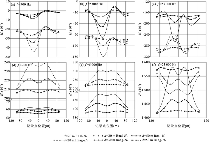
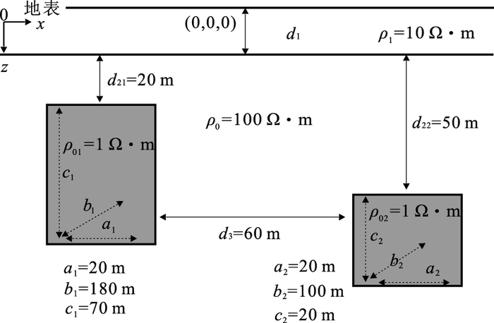
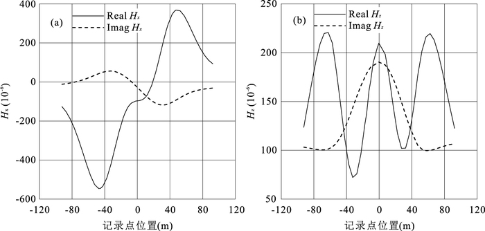
The finite-element method and application in EM exploration are well-developed. However, applications of the technology are focused mostly on ground and marine EM. Little attention has been put on airborne EM. Based on the previous research, we work on three-dimensional (3D) modeling for airborne systems by vector finite-element. We apply double-curl inhomogeneous vector Helmholtz equation for the second field and obtain the variational equations by using the generalized variational principle. By dividing the model domain into hexahedral elements and putting the field on the edge, we use linear interpolation for each element and put them together to set up the linear equations. For the multiple-source problem of AEM, we use the MUMPS solver that could achieve satisfying results both on speed and accuracy. We test the stability of our algorithm on a single abnormal body model first and check the practicability of the algorithm by simulating on typical geoelectrical models. The model results show that the overburden and the vertical contacting zone have great influence on the AEM responses.
The finite-element method and application in EM exploration are well-developed. However, applications of the technology are focused mostly on ground and marine EM. Little attention has been put on airborne EM. Based on the previous research, we work on three-dimensional (3D) modeling for airborne systems by vector finite-element. We apply double-curl inhomogeneous vector Helmholtz equation for the second field and obtain the variational equations by using the generalized variational principle. By dividing the model domain into hexahedral elements and putting the field on the edge, we use linear interpolation for each element and put them together to set up the linear equations. For the multiple-source problem of AEM, we use the MUMPS solver that could achieve satisfying results both on speed and accuracy. We test the stability of our algorithm on a single abnormal body model first and check the practicability of the algorithm by simulating on typical geoelectrical models. The model results show that the overburden and the vertical contacting zone have great influence on the AEM responses.


2016, 41(2): 343-350.
doi: 10.3799/dqkx.2016.026
Abstract:
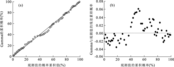
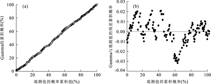
Loess landslide is the most catastrophic geohazard in the northwest area of China. Frequency distribution plays an important role in prediction and risk assessment of landslides since it can be used to find out certain distribution laws in different landslides. In this paper, the loess landslide distribution is studied by using method of grain size analysis theory, and the authors put forward the concept of landslide size diameter and use the Gamma distribution curve to fit size-frequency of landslides in different landforms of the loess plateau. The results show that: (1) At the regional scale, landslides can be viewed as "particles" widely distributed in the area, regional landslide scale percentage and its distribution can be obtained by application of grain size analysis theories and methods; (2) At log-log coordinates, frequency curve has a "rollover effect", and the Gamma distribution function describes well the size frequency distribution of landslides; (3) The loess landslide scale variation or discrete degree decreases from loess tableland to loess hill in Baota district which is mainly covered by loess ridge suffering most serious threat of the landslide disasters both in number and size.
Loess landslide is the most catastrophic geohazard in the northwest area of China. Frequency distribution plays an important role in prediction and risk assessment of landslides since it can be used to find out certain distribution laws in different landslides. In this paper, the loess landslide distribution is studied by using method of grain size analysis theory, and the authors put forward the concept of landslide size diameter and use the Gamma distribution curve to fit size-frequency of landslides in different landforms of the loess plateau. The results show that: (1) At the regional scale, landslides can be viewed as "particles" widely distributed in the area, regional landslide scale percentage and its distribution can be obtained by application of grain size analysis theories and methods; (2) At log-log coordinates, frequency curve has a "rollover effect", and the Gamma distribution function describes well the size frequency distribution of landslides; (3) The loess landslide scale variation or discrete degree decreases from loess tableland to loess hill in Baota district which is mainly covered by loess ridge suffering most serious threat of the landslide disasters both in number and size.


2016, 41(2): 351-360.
doi: 10.3799/dqkx.2016.027
Abstract:
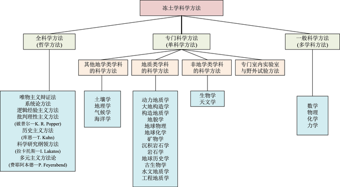
Frozen soil is categorized as a "special" soil type in soil science. We use principles of philosophy to describe research issues, system types, discipline structure, research objectives and research methodology for geocryology in this paper, on the basis of problem types of geology and Russian theories of engineering geology. First, frozen soil is redefined, and then the research objectives of frozen soil are illustrated from their morphological diversity; secondly, three problem types in the field of frozen soil are generalized as follows: "issues of today", "issues of yesterday" and "issues of tomorrow"; thirdly, the research system of geocryology is divided into the permafrost-engineering system, and the permafrost-environment system, according to its system types and the dynamic change among engineering, frozen soil and environment, and the interaction and mutual conditioning of its various subsystems (circle) are expounded; fourthly, the prospection of theory and practice of geocryology is discussed in the framework of discipline structure of general engineering geology; finally the research methods of geocryology are classified, and the interrelation between the frozen soil and other disciplines is explained.
Frozen soil is categorized as a "special" soil type in soil science. We use principles of philosophy to describe research issues, system types, discipline structure, research objectives and research methodology for geocryology in this paper, on the basis of problem types of geology and Russian theories of engineering geology. First, frozen soil is redefined, and then the research objectives of frozen soil are illustrated from their morphological diversity; secondly, three problem types in the field of frozen soil are generalized as follows: "issues of today", "issues of yesterday" and "issues of tomorrow"; thirdly, the research system of geocryology is divided into the permafrost-engineering system, and the permafrost-environment system, according to its system types and the dynamic change among engineering, frozen soil and environment, and the interaction and mutual conditioning of its various subsystems (circle) are expounded; fourthly, the prospection of theory and practice of geocryology is discussed in the framework of discipline structure of general engineering geology; finally the research methods of geocryology are classified, and the interrelation between the frozen soil and other disciplines is explained.


2016, 41(2): 252-264.
doi: 10.3799/dqkx.2016.019
Abstract:
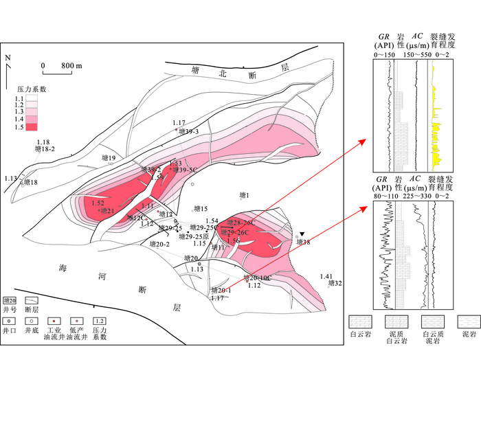
The\begin{document} ${{\text{E}}_{1}}s_{3}^{5}$ \end{document}
The


Geotectonic Setting of Coal-Bearing Basins Being Transformed into Coal-and Gas-(Oil-) Bearing Basins
2016, 41(2): 265-278.
doi: 10.3799/dqkx.2016.020
Abstract:
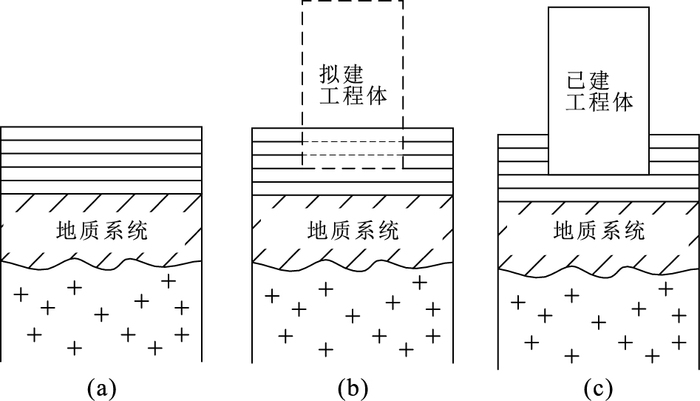
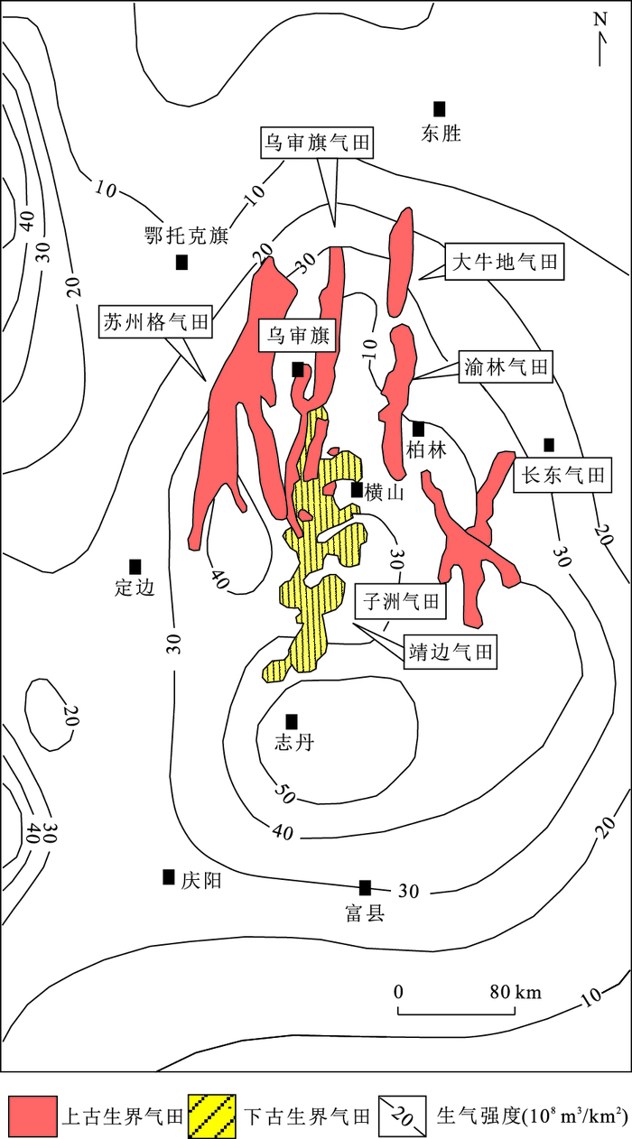
The development of large coal-bearing gas fields is a major part of the rapid growth of the nature gas resource and production in China, this paper discusses the forming geotectonic setting affecting the hydrocarbon accumulation during and after the coal-bearing strata source rocks depositon period based on the distribution features of large coal-bearing gas fields, aiming to clarify the exploration potential of the large coal-related gas fields in China. It is found that potential coal-related basins being transformed into the coal-and gas-(oil-) bearing basins share the following key factors with different tectonic evolutions: there should mainly be stable subsidence both during and after the deposition of coal-bearing strata, and the various geotectonisms should effectively be matching to each other, and ensuring the total gas accumulation should be much larger than the total gas dissipation. The longer the above-mentioned geotectonic process is and the better matched the geotectonic factors are, the more favorable to large coal-and gas-(oil-) bearing basin formation. The coal-related basins are confirmed to be the most promising ones for future exploration due to the fact that they are major gas-source rocks and they remain the major exploration targets for large gas fields ensuring sharp increase of the production of natural gas industry.
The development of large coal-bearing gas fields is a major part of the rapid growth of the nature gas resource and production in China, this paper discusses the forming geotectonic setting affecting the hydrocarbon accumulation during and after the coal-bearing strata source rocks depositon period based on the distribution features of large coal-bearing gas fields, aiming to clarify the exploration potential of the large coal-related gas fields in China. It is found that potential coal-related basins being transformed into the coal-and gas-(oil-) bearing basins share the following key factors with different tectonic evolutions: there should mainly be stable subsidence both during and after the deposition of coal-bearing strata, and the various geotectonisms should effectively be matching to each other, and ensuring the total gas accumulation should be much larger than the total gas dissipation. The longer the above-mentioned geotectonic process is and the better matched the geotectonic factors are, the more favorable to large coal-and gas-(oil-) bearing basin formation. The coal-related basins are confirmed to be the most promising ones for future exploration due to the fact that they are major gas-source rocks and they remain the major exploration targets for large gas fields ensuring sharp increase of the production of natural gas industry.


2016, 41(2): 279-292.
doi: 10.3799/dqkx.2016.021
Abstract:
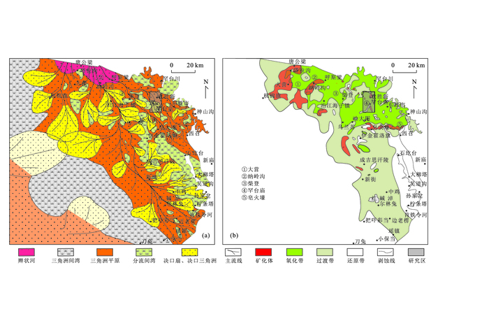
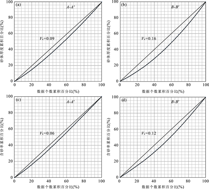
Uranium reservoir heterogeneity plays an important role in the process of uranium mineralization. However, people have not been recognized and need further study on the uranium reservoir heterogeneity of Hantaimiao region in Ordos Basin. By plane mapping and statistical analysis of quantitative heterogeneity parameters is study area, it shows that the heterogeneity of uranium reservoir sand body can be quantitatively characterized by sandstone thickness, sandstone percentage, sandstone grain size, number and cumulative thickness of clay isolated barrier beds, and original organic carbon content. It is found that uranium reservoir heterogeneity is weak at the central axis area of braided distributary channel sand body; and becomes strong at the both edges of the central axis area of sand body and the downstream area. Through the comprehensive analysis of the relationship between quantitative heterogeneity parameters and uranium mineralization information, uranium reservoir heterogeneity is divided into class I (weak), class II (medium) and class III (strong). The uranium mineralization in class II reservoirs is the most active. And the quantitative evaluation index system for uranium reservoir heterogeneity, which is comprehensively evaluated by multi parameters, is established ultimately. It is generally held in previous qualitative research that uranium reservoir heterogeneity controls uranium mineralization process and also affects the in-situ leaching uranium process. This quantitative evaluation index system will be able to predict more accurately the uranium target area and to optimize the project deployment of in-situ leaching uranium, improving the efficiency of the exploration and mining of uranium.
Uranium reservoir heterogeneity plays an important role in the process of uranium mineralization. However, people have not been recognized and need further study on the uranium reservoir heterogeneity of Hantaimiao region in Ordos Basin. By plane mapping and statistical analysis of quantitative heterogeneity parameters is study area, it shows that the heterogeneity of uranium reservoir sand body can be quantitatively characterized by sandstone thickness, sandstone percentage, sandstone grain size, number and cumulative thickness of clay isolated barrier beds, and original organic carbon content. It is found that uranium reservoir heterogeneity is weak at the central axis area of braided distributary channel sand body; and becomes strong at the both edges of the central axis area of sand body and the downstream area. Through the comprehensive analysis of the relationship between quantitative heterogeneity parameters and uranium mineralization information, uranium reservoir heterogeneity is divided into class I (weak), class II (medium) and class III (strong). The uranium mineralization in class II reservoirs is the most active. And the quantitative evaluation index system for uranium reservoir heterogeneity, which is comprehensively evaluated by multi parameters, is established ultimately. It is generally held in previous qualitative research that uranium reservoir heterogeneity controls uranium mineralization process and also affects the in-situ leaching uranium process. This quantitative evaluation index system will be able to predict more accurately the uranium target area and to optimize the project deployment of in-situ leaching uranium, improving the efficiency of the exploration and mining of uranium.


2016, 41(2): 293-316.
doi: 10.3799/dqkx.2016.022
Abstract:
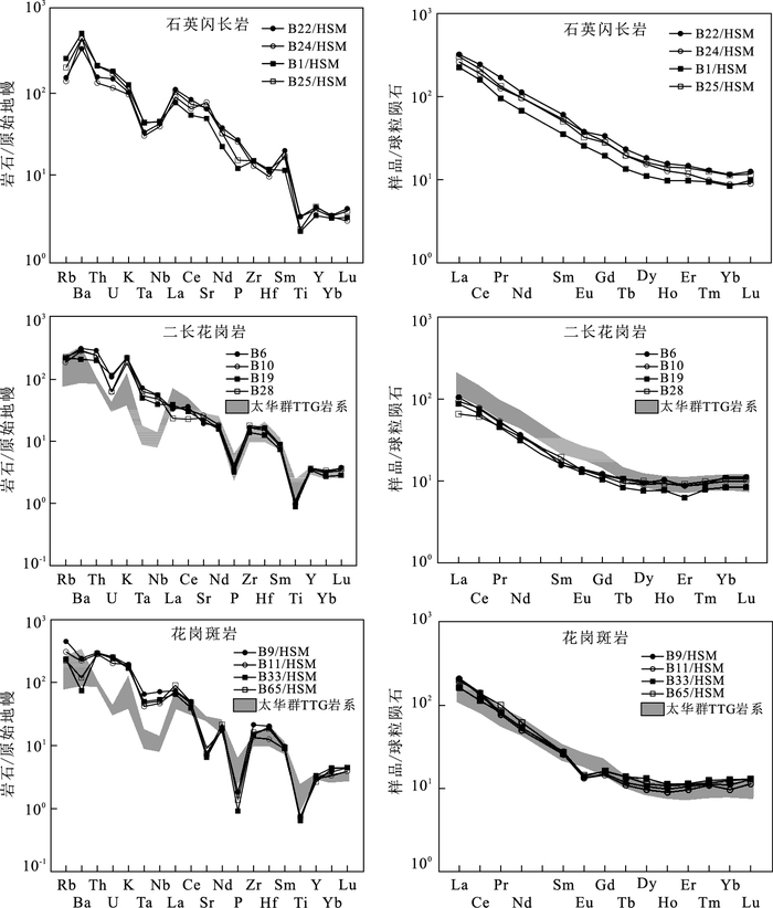
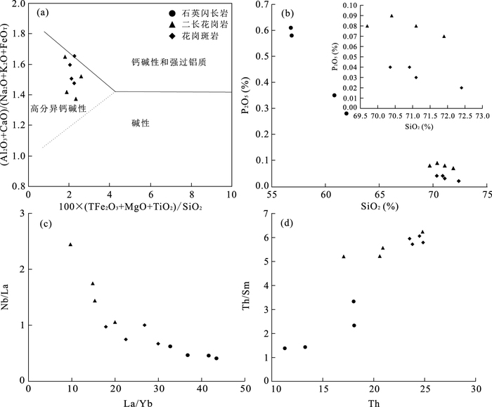
The Huoshenmiao pluton located in the west of the Luanchuan ore district, southern margin of the North China Craton (NCC) is mainly composed of quartz diorite, monzo-granite and granite porphyry. The Huoshenmiao pluton is closely related to the Huoshenmiao Mo deposit. While the degree of research on the Huoshenmiao pluton is very low, which seriously restrict the understanding of the genesis of the Huoshenmiao Mo deposit. Three types of rock including quartz diorite, monzo-granite and granite porphyry has been researched by zircon U-Pb chronology, geochemistry and Hf isotope. The forming ages of quartz diorite, monzo-granite and granite porphyry are 150.3±0.6Ma, 146.0±0.6Ma and 145.1±0.5Ma respectively, and are products of the second magmatism of the Luanchuan ore district, Late Jurassic. Geochemistry and zircon Hf isotope show that the Huoshenmiao pluton belongs to I-type granite, and it results from ascending magma formed by partial melting of different source regions. The quartz diorite stems from remelting of the enriched mantle, while the monzo-granite and granite porphyry are the products of mafic magma derived from remelting of the enriched mantle mixed with felsic magma derived from remelting of the Taihua TTG.
The Huoshenmiao pluton located in the west of the Luanchuan ore district, southern margin of the North China Craton (NCC) is mainly composed of quartz diorite, monzo-granite and granite porphyry. The Huoshenmiao pluton is closely related to the Huoshenmiao Mo deposit. While the degree of research on the Huoshenmiao pluton is very low, which seriously restrict the understanding of the genesis of the Huoshenmiao Mo deposit. Three types of rock including quartz diorite, monzo-granite and granite porphyry has been researched by zircon U-Pb chronology, geochemistry and Hf isotope. The forming ages of quartz diorite, monzo-granite and granite porphyry are 150.3±0.6Ma, 146.0±0.6Ma and 145.1±0.5Ma respectively, and are products of the second magmatism of the Luanchuan ore district, Late Jurassic. Geochemistry and zircon Hf isotope show that the Huoshenmiao pluton belongs to I-type granite, and it results from ascending magma formed by partial melting of different source regions. The quartz diorite stems from remelting of the enriched mantle, while the monzo-granite and granite porphyry are the products of mafic magma derived from remelting of the enriched mantle mixed with felsic magma derived from remelting of the Taihua TTG.


2016, 41(2): 317-324.
doi: 10.3799/dqkx.2016.023
Abstract:
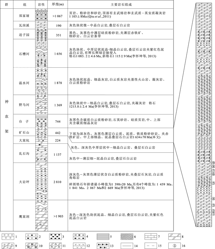
The Shennongjia Group, located on the northern margin of the Yangtze Craton, shows a series of well-preserved succession of the Mesoproterozoic carbonate strata. However, geochronological data collected from this area are limited. In this study, we report a Pb-Pb isochron age for the Kuangshishan Formation of the Shennongjia Group. The 206Pb/204Pb ratios of the dolostone of the Kuangshishan Formation show wide variations from 18.753 to 23.106. On the contrary, the 207Pb/204Pb ratios and the 208Pb/204Pb ratios have a limited range from 15.606 to 16.046 and 37.793 to 38.599, respectively. 8 dolostone samples data show an obvious linear relationship between 206Pb/204Pb and 207Pb/204Pb, yielding a Pb-Pb isochron age of 1632±75Ma (MSWD=8.7) which represent the depositional age for the Kuangshishan Formation. This age accords well with previous published data, indicating that a precise stratigraphic age of the ancient carbonate strata can be obtained through Pb-Pb dating technique. Combined with previous researches, we suggest that the age span of the Shennongjia Group is 1600 to 1100Ma of Mesoproterozoic.
The Shennongjia Group, located on the northern margin of the Yangtze Craton, shows a series of well-preserved succession of the Mesoproterozoic carbonate strata. However, geochronological data collected from this area are limited. In this study, we report a Pb-Pb isochron age for the Kuangshishan Formation of the Shennongjia Group. The 206Pb/204Pb ratios of the dolostone of the Kuangshishan Formation show wide variations from 18.753 to 23.106. On the contrary, the 207Pb/204Pb ratios and the 208Pb/204Pb ratios have a limited range from 15.606 to 16.046 and 37.793 to 38.599, respectively. 8 dolostone samples data show an obvious linear relationship between 206Pb/204Pb and 207Pb/204Pb, yielding a Pb-Pb isochron age of 1632±75Ma (MSWD=8.7) which represent the depositional age for the Kuangshishan Formation. This age accords well with previous published data, indicating that a precise stratigraphic age of the ancient carbonate strata can be obtained through Pb-Pb dating technique. Combined with previous researches, we suggest that the age span of the Shennongjia Group is 1600 to 1100Ma of Mesoproterozoic.