2016 Vol. 41, No. 3
Display Method:
 PDF 279KB
2016, 41(3): 361-372.
doi: 10.3799/dqkx.2016.028
Abstract:
Compared with the sequences of marine basins, sequence stratigraphic architecture of non-marine basins is characterized by multi-variation and uncertainty. Migrated sequence stratigraphic architecture is one non-normal type in the evolution of continental lacustrine rift basin, which is rare documented. Based on the sequence stratigraphic units analysis of Paleogene Wenchang Formation of Huizhou and Enping sags, Zhu Ⅰ Depression, Pearl River Mouth Basin, this paper defined the concept of migrated sequence stratigraphic architecture and divided into autogenic and allogenic migration. Autogenic migrated sequences are mainly controlled by horizontal displacement of low-angle syndepositional normal fault, whereas allogenic migrated sequences are controlled by the different tectonic activation episodes of boundary fault on both sides of the basin. In other words, autogenic and allogenic migrated sequences are controlled by one and two syndepositional boundary fault, respectively. During the lateral migration of sequences, reservoirs and source rocks controlled by sequence stratigraphic units at multiple scales also migrate and stack laterally. This helps the high-efficient configuration of hydrocarbon accumulation factors (e.g., source rock, reservoir, and seal) to generate reservoir combination with multiple blocks and multiple strata.
Compared with the sequences of marine basins, sequence stratigraphic architecture of non-marine basins is characterized by multi-variation and uncertainty. Migrated sequence stratigraphic architecture is one non-normal type in the evolution of continental lacustrine rift basin, which is rare documented. Based on the sequence stratigraphic units analysis of Paleogene Wenchang Formation of Huizhou and Enping sags, Zhu Ⅰ Depression, Pearl River Mouth Basin, this paper defined the concept of migrated sequence stratigraphic architecture and divided into autogenic and allogenic migration. Autogenic migrated sequences are mainly controlled by horizontal displacement of low-angle syndepositional normal fault, whereas allogenic migrated sequences are controlled by the different tectonic activation episodes of boundary fault on both sides of the basin. In other words, autogenic and allogenic migrated sequences are controlled by one and two syndepositional boundary fault, respectively. During the lateral migration of sequences, reservoirs and source rocks controlled by sequence stratigraphic units at multiple scales also migrate and stack laterally. This helps the high-efficient configuration of hydrocarbon accumulation factors (e.g., source rock, reservoir, and seal) to generate reservoir combination with multiple blocks and multiple strata.


2016, 41(3): 373-384.
doi: 10.3799/dqkx.2016.029
Abstract:
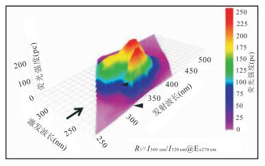
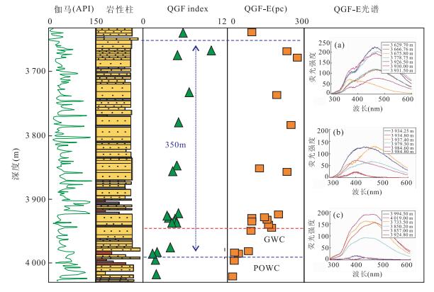
Quantitative fluorescence techniques, including a suite of techniques, such as quantitative grain fluorescence (QGF), quantitative grain fluorescence on extract (QGF-E), QGF plus (QGF+), total scanning fluorescence (TSF), and TSF on crushed inclusion extracts (iTSF), have been widely applied in studying hydrocarbon charge history and accumulations. The techniques can be used to delineate the current (residual) oil zone and palaeo oil zone, reconstruct hydrocarbon accumulation history, identify oil migration pathways, and determine oil properties. Compared with the petrographic and organic geochemical methods, the fluorescence techniques have the advantages of extremely sensitive, easy to use and fast turn-around. In this paper, we present the principles, sample preparation procedures, key parameters and some field application examples in hydrocarbon accumulation studies, including (1) the palaeo and residual oil zone delineation and reservoir evolution history reconstruction using the QGF and QGF-E techniques; (2) evaluating tight oil reservoir zones, which are difficult to be detected by well logging data using the QGF-E technique; (3) cross-correlation between TSF, iTSF, QGF+ spectral signatures and other geochemical parameters to detect geochemical characteristics of crude oils, core and oil inclusion extracts. Some pitfalls and other potential application of the techniques are also discussed.
Quantitative fluorescence techniques, including a suite of techniques, such as quantitative grain fluorescence (QGF), quantitative grain fluorescence on extract (QGF-E), QGF plus (QGF+), total scanning fluorescence (TSF), and TSF on crushed inclusion extracts (iTSF), have been widely applied in studying hydrocarbon charge history and accumulations. The techniques can be used to delineate the current (residual) oil zone and palaeo oil zone, reconstruct hydrocarbon accumulation history, identify oil migration pathways, and determine oil properties. Compared with the petrographic and organic geochemical methods, the fluorescence techniques have the advantages of extremely sensitive, easy to use and fast turn-around. In this paper, we present the principles, sample preparation procedures, key parameters and some field application examples in hydrocarbon accumulation studies, including (1) the palaeo and residual oil zone delineation and reservoir evolution history reconstruction using the QGF and QGF-E techniques; (2) evaluating tight oil reservoir zones, which are difficult to be detected by well logging data using the QGF-E technique; (3) cross-correlation between TSF, iTSF, QGF+ spectral signatures and other geochemical parameters to detect geochemical characteristics of crude oils, core and oil inclusion extracts. Some pitfalls and other potential application of the techniques are also discussed.


2016, 41(3): 385-393.
doi: 10.3799/dqkx.2016.030
Abstract:
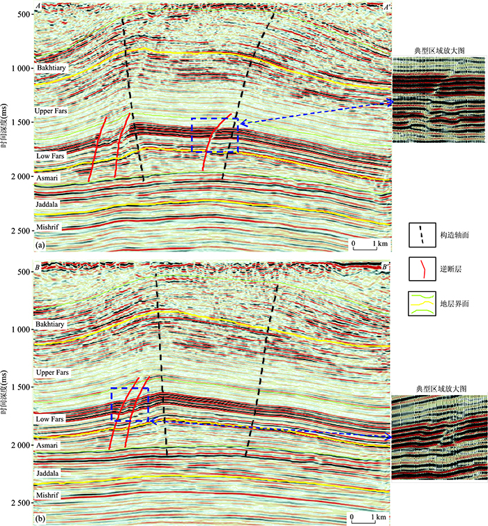
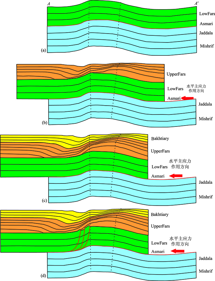
Zagros basin is one of the most important basins in the international petroleum industry because of its rich oil and gas resources and the complex structure system, and it is crucial to the understanding of the structural characteristics of Zagros basin as to whether oblique-thrust fault-related-fold exist or not. Based on the fault-related-fold theories, and by using the dip angle domain analysis and fold axial plane analysis methods, geometric analysis of the structure of Buzurgan anticline in Zagros basin was carried out, and the time structure of T0 diagrams, the time domain horizontal slices and the seismic profiles parallel to the strike of the fault of Buzurgan anticline were made. On this basis, relying on the geometric feature recognition of oblique-thrust fault-related-fold, the geometry deformation style of oblique-thrust fault-related-fold of Buzurgan anticline was systematically interpreted. And the forming processes of the Buzurgan oblique-thrust fault-related-fold in Zagros basin were reproduced by using the forward balanced cross section technique, the rationality and reliability of the above-mentioned interpretation about the Buzurgan oblique-thrust fault-related-fold was eventually validated.
Zagros basin is one of the most important basins in the international petroleum industry because of its rich oil and gas resources and the complex structure system, and it is crucial to the understanding of the structural characteristics of Zagros basin as to whether oblique-thrust fault-related-fold exist or not. Based on the fault-related-fold theories, and by using the dip angle domain analysis and fold axial plane analysis methods, geometric analysis of the structure of Buzurgan anticline in Zagros basin was carried out, and the time structure of T0 diagrams, the time domain horizontal slices and the seismic profiles parallel to the strike of the fault of Buzurgan anticline were made. On this basis, relying on the geometric feature recognition of oblique-thrust fault-related-fold, the geometry deformation style of oblique-thrust fault-related-fold of Buzurgan anticline was systematically interpreted. And the forming processes of the Buzurgan oblique-thrust fault-related-fold in Zagros basin were reproduced by using the forward balanced cross section technique, the rationality and reliability of the above-mentioned interpretation about the Buzurgan oblique-thrust fault-related-fold was eventually validated.


2016, 41(3): 394-402.
doi: 10.3799/dqkx.2016.031
Abstract:
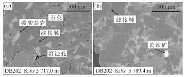
The tight sandstone reservoirs below the salt and gypsum unit in the Dabei area of the Kuqa foreland basin are characterized by deep burial, low porosity and permeability, which produce natural gas and minor light oil. The relationship between tight sandstone reservoir formation and petroleum charge in the Dabei area of the Kuqa foreland basin are studied by combining the porosity evolution of the tight sandstone reservoirs based on the analysis the tight sandstone reservoirs characters, natural gas and light oil maturity, and petroleum charge history. The pore space of the tight sandstone reservoirs below the salt and gypsum unit in the Dabei area are dominated by secondary intergranular dissolution pores, most of which are filled by bitumen and have an excellent interconnectivity. Strong compaction is the important cause for the development of the tight sandstone reservoirs and carbonate cements should form before the Kuqa formation deposition to cause the porosity decreasing. The presence of widespread bitumen observed in the K1bs tight sandstone reservoir, organic geochemistry characters of light oil and gas, results of fluid inclusions investigation indicate that there had been two episodes of oil and one episode of gas charge in the tight sandstone reservoir. The late episode of oil charge identified in the tight sandstone reservoir is estimated to be at around 5-4 Ma, responding to the beginning of Kuqa formation deposition. The timing of the natural gas charge is estimated at around 3-2 Ma and are belong to the period of the uplift and erosion. The tight sandstone reservoirs below the salt and gypsum unit in the Dabei area of the Kuqa foreland basin have shallower burial deep and higher porosity during the period of oil charge than natural gas charge because the sandstone reservoirs had experienced strong compaction and cause the formation of tight sandstone reservoirs.
The tight sandstone reservoirs below the salt and gypsum unit in the Dabei area of the Kuqa foreland basin are characterized by deep burial, low porosity and permeability, which produce natural gas and minor light oil. The relationship between tight sandstone reservoir formation and petroleum charge in the Dabei area of the Kuqa foreland basin are studied by combining the porosity evolution of the tight sandstone reservoirs based on the analysis the tight sandstone reservoirs characters, natural gas and light oil maturity, and petroleum charge history. The pore space of the tight sandstone reservoirs below the salt and gypsum unit in the Dabei area are dominated by secondary intergranular dissolution pores, most of which are filled by bitumen and have an excellent interconnectivity. Strong compaction is the important cause for the development of the tight sandstone reservoirs and carbonate cements should form before the Kuqa formation deposition to cause the porosity decreasing. The presence of widespread bitumen observed in the K1bs tight sandstone reservoir, organic geochemistry characters of light oil and gas, results of fluid inclusions investigation indicate that there had been two episodes of oil and one episode of gas charge in the tight sandstone reservoir. The late episode of oil charge identified in the tight sandstone reservoir is estimated to be at around 5-4 Ma, responding to the beginning of Kuqa formation deposition. The timing of the natural gas charge is estimated at around 3-2 Ma and are belong to the period of the uplift and erosion. The tight sandstone reservoirs below the salt and gypsum unit in the Dabei area of the Kuqa foreland basin have shallower burial deep and higher porosity during the period of oil charge than natural gas charge because the sandstone reservoirs had experienced strong compaction and cause the formation of tight sandstone reservoirs.


2016, 41(3): 403-415.
doi: 10.3799/dqkx.2016.032
Abstract:
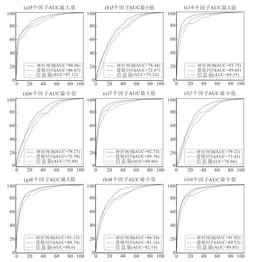
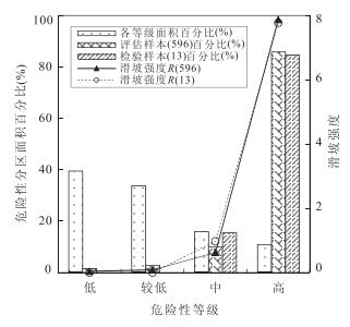
A plenty of landslide susceptibility mapping studies in south west China have been reported in literatures. However, the assessment studies of rainfall-triggered landslides in south east China are still limited, particularly for those dominated by plum rains. Based on GIS and grid analysis, a study case in Cunan county is selected for demonstrating the comparison of applying three methods for landslide susceptibility assessment. They include artificial neural networks (ANN), logistic regression (LGR) and information model (IFM). The landslide inventory includes totally 596 landslides, which is established based on the results of remote sensing interpretation and detail survey. Totally 32 models are established by altering different combinations of controlling factors (CFs) out of totally 9 factors, including elevation, slope angle, slope aspect, slope curvature, lithology, distance from faults, distance from roads, distance from construction lands and vegetation. The indicator of Area Under Curve (AUC) is used for model evaluation. The ANN model could achieve the AUC of 93.75%, which outperforms LGR and IFM with the AUC of 89.76% and 90.06%, respectively. It also performs well in prediction to achieve the AUC of 94.75% compared to those (i.e. 94.33% and 77.21%) from LGR and IFM, where 13 landslides occurred in 2014 during plum-rain season are used for verification. The results of susceptibility zoning based on the derived susceptibility map using ANN also show reasonable, indicating the increases of landslide intensity with the increasing of susceptibility levels. Overall, this study demonstrates the best practices of applying different methods in rainfall-triggered landslide susceptibility assessment, which could be the reference for similar studies elsewhere in west Zhejiang province.
A plenty of landslide susceptibility mapping studies in south west China have been reported in literatures. However, the assessment studies of rainfall-triggered landslides in south east China are still limited, particularly for those dominated by plum rains. Based on GIS and grid analysis, a study case in Cunan county is selected for demonstrating the comparison of applying three methods for landslide susceptibility assessment. They include artificial neural networks (ANN), logistic regression (LGR) and information model (IFM). The landslide inventory includes totally 596 landslides, which is established based on the results of remote sensing interpretation and detail survey. Totally 32 models are established by altering different combinations of controlling factors (CFs) out of totally 9 factors, including elevation, slope angle, slope aspect, slope curvature, lithology, distance from faults, distance from roads, distance from construction lands and vegetation. The indicator of Area Under Curve (AUC) is used for model evaluation. The ANN model could achieve the AUC of 93.75%, which outperforms LGR and IFM with the AUC of 89.76% and 90.06%, respectively. It also performs well in prediction to achieve the AUC of 94.75% compared to those (i.e. 94.33% and 77.21%) from LGR and IFM, where 13 landslides occurred in 2014 during plum-rain season are used for verification. The results of susceptibility zoning based on the derived susceptibility map using ANN also show reasonable, indicating the increases of landslide intensity with the increasing of susceptibility levels. Overall, this study demonstrates the best practices of applying different methods in rainfall-triggered landslide susceptibility assessment, which could be the reference for similar studies elsewhere in west Zhejiang province.


2016, 41(3): 416-424.
doi: 10.3799/dqkx.2016.033
Abstract:
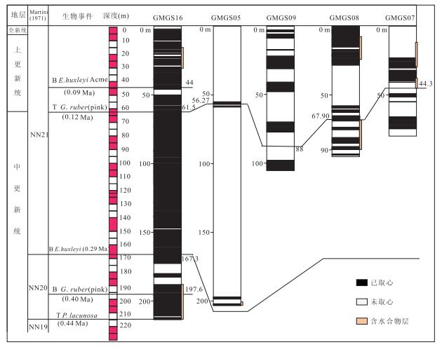
Middle Pleistocene to Holocene calcareous nannofossils and foraminifera biostratigraphy in 5 sites (GMGS05、GMGS07、GMGS08、GMGS09 and GMGS16) from the Dongsha gas hydrate drilling area of the northeastern South China Sea have been studied. A total of 3 nannofossils events and 2 foraminifera events from middle Pleistocene to Holocene were recognized. The oldest sediments recovered are in an age of middle Pleistocene, younger than 0.50 Ma, the age assigned for gas hydrate occurrence zone is middle Pleistocene to Holocene in sites GMGS05、GMGS07、GMGS08 and GMGS16.Sedimentation rates varied from 36.9 cm/ka to 73.3 cm/ka, and reaching the highest average value 54.2 cm/ka since 0.12 Ma in the Dongsha gas hydrate drilling area. The mean sedimentation rate has been 47.4 cm/ka since 0.44 Ma.The results suggested that the gas hydrate drilling area is located at sedimentary body with high sedimentation rate, which is advantageous to gas hydrate formation. This conclusion is consistent with the previous research.
Middle Pleistocene to Holocene calcareous nannofossils and foraminifera biostratigraphy in 5 sites (GMGS05、GMGS07、GMGS08、GMGS09 and GMGS16) from the Dongsha gas hydrate drilling area of the northeastern South China Sea have been studied. A total of 3 nannofossils events and 2 foraminifera events from middle Pleistocene to Holocene were recognized. The oldest sediments recovered are in an age of middle Pleistocene, younger than 0.50 Ma, the age assigned for gas hydrate occurrence zone is middle Pleistocene to Holocene in sites GMGS05、GMGS07、GMGS08 and GMGS16.Sedimentation rates varied from 36.9 cm/ka to 73.3 cm/ka, and reaching the highest average value 54.2 cm/ka since 0.12 Ma in the Dongsha gas hydrate drilling area. The mean sedimentation rate has been 47.4 cm/ka since 0.44 Ma.The results suggested that the gas hydrate drilling area is located at sedimentary body with high sedimentation rate, which is advantageous to gas hydrate formation. This conclusion is consistent with the previous research.


2016, 41(3): 425-432.
doi: 10.3799/dqkx.2016.034
Abstract:
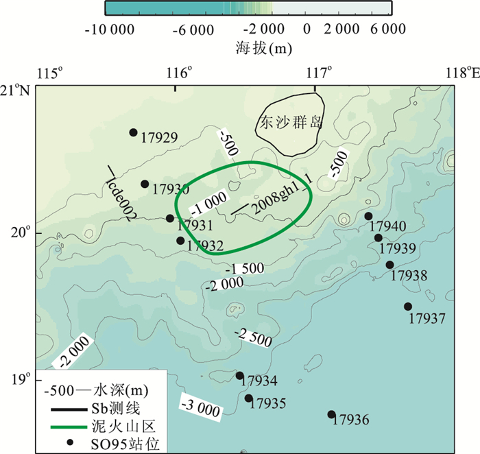
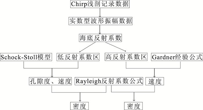
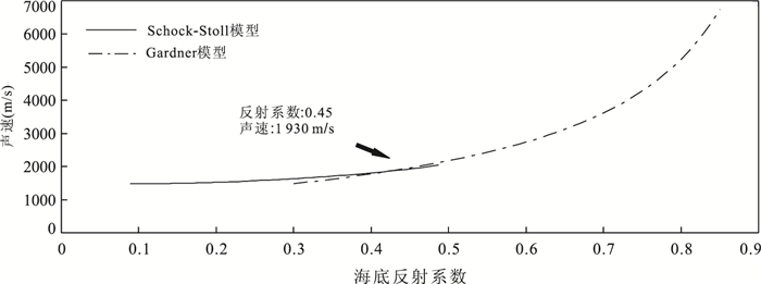
Mud volcanoes are imaged from Chirp sub-bottom profiles across the southwest of Dongsha Islands. In order to quantify the physical properties of the seabed, this paper studies the inversion of the Chirp sub-bottom data. First, reflection coefficients of the seabed are calculated, the results show that the reflection magnitudes of the seabed vary from 0.1-0.8. The physical properties (velocity, density, porosity etc.) of the seabed are obtained by the Schock-Stoll Model and the empirical relationships among the physical properties for the part reflection coefficients smaller than 0.45, and the physical properties (velocity and density) of the seabed are obtained by Gardner empirical equation for the part reflection coefficients larger than 0.45. Results of the inversion show that the physical properties vary greatly with the maximum velocity of 5 237 m/s and density of 2.673 g/cm3. The Chirp data-based physical properties highly coincide with the laboratory measurements for sampled sediments, thus provides us a remote acoustic method for estimating the physical properties of the seabed.
Mud volcanoes are imaged from Chirp sub-bottom profiles across the southwest of Dongsha Islands. In order to quantify the physical properties of the seabed, this paper studies the inversion of the Chirp sub-bottom data. First, reflection coefficients of the seabed are calculated, the results show that the reflection magnitudes of the seabed vary from 0.1-0.8. The physical properties (velocity, density, porosity etc.) of the seabed are obtained by the Schock-Stoll Model and the empirical relationships among the physical properties for the part reflection coefficients smaller than 0.45, and the physical properties (velocity and density) of the seabed are obtained by Gardner empirical equation for the part reflection coefficients larger than 0.45. Results of the inversion show that the physical properties vary greatly with the maximum velocity of 5 237 m/s and density of 2.673 g/cm3. The Chirp data-based physical properties highly coincide with the laboratory measurements for sampled sediments, thus provides us a remote acoustic method for estimating the physical properties of the seabed.


2016, 41(3): 433-440.
doi: 10.3799/dqkx.2016.035
Abstract:
Among the unconventional gas supply sources, tight-sand gas constitutes a significant percentage, which is the most available part under current technology. It can be divided into two types, continuous-type and trap-type. Geological and geochemical differences in characteristics on migration, accumulation, and distribution between trap-type and continuous-type tight-sand gas were compared systematically. Through physical simulation experiments, the dynamic genetic mechanism of near-source accumulation of continuous-type tight-sand gas was revealed. Trap-type tight-sand gas is the result of natural gas accumulation for a long migration distance with a good conducting system, causing an obvious fractionation on gas composition and carbon isotope and resulting in the following characteristics-"convergence in conventional traps, with edge and bottom water, high-quality sealing". Continuous-type tight-sand gas is the result of near-source cumulative accumulation. Consequently, the gas composition and carbon isotope fractionation effect is unconspicuous, and discreteness exists among carbon isotopes in the same area. Different from trap-type, the continuous-type tight-sand gas exhibits the following characteristics such as "continuous distribution, near-source aggregation, complex or inverted gas / water distribution". The near-source accumulation of continuous-type tight-sand gas is consequence of counterbalance between force and resistance when gas migrates in nanoscale pore-throats developed in tight sandstone reservoirs. Before the natural gas migrates to the critical gas-water interface, it is separated into gas system and water system by the inversed gas-water interface. The gas migration force is abnormal gas pressure, while the need to generate buoyancy cannot be met. The gas migration resistances include overburden formation water pressure and capillary pressure. The magic trap of continuous-type tight-sand gas can be considered unconventional dynamic trap which core contents can be summarized as "(almost) nanoscale pore-throat, gas migrate follows the piston principle, buoyancy does not work, balance between force and resistance determines gas-water interface".
Among the unconventional gas supply sources, tight-sand gas constitutes a significant percentage, which is the most available part under current technology. It can be divided into two types, continuous-type and trap-type. Geological and geochemical differences in characteristics on migration, accumulation, and distribution between trap-type and continuous-type tight-sand gas were compared systematically. Through physical simulation experiments, the dynamic genetic mechanism of near-source accumulation of continuous-type tight-sand gas was revealed. Trap-type tight-sand gas is the result of natural gas accumulation for a long migration distance with a good conducting system, causing an obvious fractionation on gas composition and carbon isotope and resulting in the following characteristics-"convergence in conventional traps, with edge and bottom water, high-quality sealing". Continuous-type tight-sand gas is the result of near-source cumulative accumulation. Consequently, the gas composition and carbon isotope fractionation effect is unconspicuous, and discreteness exists among carbon isotopes in the same area. Different from trap-type, the continuous-type tight-sand gas exhibits the following characteristics such as "continuous distribution, near-source aggregation, complex or inverted gas / water distribution". The near-source accumulation of continuous-type tight-sand gas is consequence of counterbalance between force and resistance when gas migrates in nanoscale pore-throats developed in tight sandstone reservoirs. Before the natural gas migrates to the critical gas-water interface, it is separated into gas system and water system by the inversed gas-water interface. The gas migration force is abnormal gas pressure, while the need to generate buoyancy cannot be met. The gas migration resistances include overburden formation water pressure and capillary pressure. The magic trap of continuous-type tight-sand gas can be considered unconventional dynamic trap which core contents can be summarized as "(almost) nanoscale pore-throat, gas migrate follows the piston principle, buoyancy does not work, balance between force and resistance determines gas-water interface".


2016, 41(3): 441-451.
doi: 10.3799/dqkx.2016.036
Abstract:
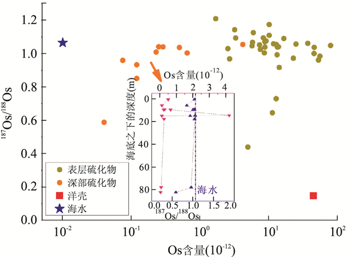
The hydrothermal fluids occur along the mid-ocean ridges are capable of transporting a great amount Os from deep interior of the earth where it is relatively enriched to the ocean floor, this process plays a significant role in the global cycling of Os. The geochemical behavior of Os during the various stages of the hydrothermal circulation, its distribution and evolution features and source contributions are estimated basing on the chemical speciation, concentrations and isotopic compositions of Os in the sources for the hydrothermal systems and the hydrothermal deposits. The Os data from the sediment-free mid-ocean ridge systems indicated that there is a nearly complete Os isotope exchange between the interacting seawater and the oceanic crust during the hydrothermal circulation, the behavior of Os appears to be controlled by the relative proportions of seawater and crustal composition in the different tectonic areas. Reactions of seawater with surrounding rock result in the radiogenic Os removing from seawater to the altered host rock, and the nonradiogenic Os lost from the wall rock to the hydrothermal fluid. The hydrothermal deposits accumulated above the seafloor carry Os which is predominately seawater-derived, the Os of the hydrothermal products beneath the the seafloor reflecting mixing of seawater-derived and ocean crust-derived Os.
The hydrothermal fluids occur along the mid-ocean ridges are capable of transporting a great amount Os from deep interior of the earth where it is relatively enriched to the ocean floor, this process plays a significant role in the global cycling of Os. The geochemical behavior of Os during the various stages of the hydrothermal circulation, its distribution and evolution features and source contributions are estimated basing on the chemical speciation, concentrations and isotopic compositions of Os in the sources for the hydrothermal systems and the hydrothermal deposits. The Os data from the sediment-free mid-ocean ridge systems indicated that there is a nearly complete Os isotope exchange between the interacting seawater and the oceanic crust during the hydrothermal circulation, the behavior of Os appears to be controlled by the relative proportions of seawater and crustal composition in the different tectonic areas. Reactions of seawater with surrounding rock result in the radiogenic Os removing from seawater to the altered host rock, and the nonradiogenic Os lost from the wall rock to the hydrothermal fluid. The hydrothermal deposits accumulated above the seafloor carry Os which is predominately seawater-derived, the Os of the hydrothermal products beneath the the seafloor reflecting mixing of seawater-derived and ocean crust-derived Os.


2016, 41(3): 452-462.
doi: 10.3799/dqkx.2016.037
Abstract:
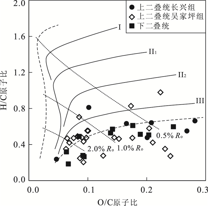
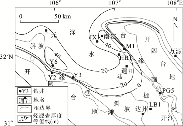
The natural gases from the Changxing Formation (P2ch) in the Yuanba gas field are mainly derived from oil cracking, but the volume of oil-cracking-gas has not been evaluated quantitatively and the source of the paleo-oil has not been studied systematically. Solid bitumen, commonly developed in the P2ch reservoirs, is a direct product of oil cracking which had finished before the regional uplift and structure deformation in the Yuanba gas field. As a result, the paleo-oil zone can be recognized by the solid bitumen. Basing on the lateral and vertical distribution of solid bitumen, seven reliable and four probable paleo-oil reservoirs have been found out. The paleo-oil accumulated in these reservoirs by volumetric method is about 6.14×10⁸ t, and the corresponding oil-cracking-gas is about 3 807.08×10⁸ m3. The volume of oil-cracking-gas is much larger than the natural gas found in the Yuanba gas field, which indicates that the oil-cracking-gas can supply sufficient gases for the present gas reservoirs, and further proves that the natural gases are mainly derived from oil cracking. The δ13C correlation of solid bitumen and kerogens from different source rocks, and total organic carbon (TOC) data show that the paleo-oil was derived from type-Ⅱ source rock mainly in the Upper Permian Wujiaping Formation, and then in the Changxing/Dalong Formation. The latter is mainly developed in Guangyuan-Nanjiang-Tongjiang area, and the hydrocarbon generated by this source rock cannot be neglected during the natural gas exploration in this area.
The natural gases from the Changxing Formation (P2ch) in the Yuanba gas field are mainly derived from oil cracking, but the volume of oil-cracking-gas has not been evaluated quantitatively and the source of the paleo-oil has not been studied systematically. Solid bitumen, commonly developed in the P2ch reservoirs, is a direct product of oil cracking which had finished before the regional uplift and structure deformation in the Yuanba gas field. As a result, the paleo-oil zone can be recognized by the solid bitumen. Basing on the lateral and vertical distribution of solid bitumen, seven reliable and four probable paleo-oil reservoirs have been found out. The paleo-oil accumulated in these reservoirs by volumetric method is about 6.14×10⁸ t, and the corresponding oil-cracking-gas is about 3 807.08×10⁸ m3. The volume of oil-cracking-gas is much larger than the natural gas found in the Yuanba gas field, which indicates that the oil-cracking-gas can supply sufficient gases for the present gas reservoirs, and further proves that the natural gases are mainly derived from oil cracking. The δ13C correlation of solid bitumen and kerogens from different source rocks, and total organic carbon (TOC) data show that the paleo-oil was derived from type-Ⅱ source rock mainly in the Upper Permian Wujiaping Formation, and then in the Changxing/Dalong Formation. The latter is mainly developed in Guangyuan-Nanjiang-Tongjiang area, and the hydrocarbon generated by this source rock cannot be neglected during the natural gas exploration in this area.


2016, 41(3): 463-474.
doi: 10.3799/dqkx.2016.038
Abstract:
Rare earth elements (REE) were analyzed by ICP-MS analysis in 138 surface sediments samples collected from in the eastern Bohai and northern Yellow Seas, China. The results indicated that the REE UCC normalization distribution pattern in surface sediments in the eastern Bohai and northern Yellow Seas was similar to that in Chinese loess, and also those of coastal rivers including the Yalu River, the Yellow River and other rivers, indicating that the sediments in study area were mainly derived from the mainland substance. Provenance discrimination results showed that the sediments in the Shandong Peninsula and southwestern shore were mainly derived from the Yellow River, the area affected by the coastal current of the Shandong Peninsula and near shore tidal current; REE composition characteristics of sediment in the eastern part in the study area were similar to the Yalu River sediments, indicating that the sediments of the eastern study area may be supplied by the Yalu River. Sediments of the western part of the study area were mainly derived from the Yellow River and Liaoning coast material input, the local presence of the Luanhe River, Liuguhe River substance. The material of southeast in the study area mainly derived from the Yellow River. The REE contents and parameters of characteristic value were analyzed by the Q cluster analysis, the study area can be divided into four different regions, Namely region in the eastern part of the North Yellow Sea (Ⅰ), the Shandong Peninsula inshore surrounding area (Ⅱ), middle area in the eastern Bohai Sea (Ⅲ) and distributions in the northwest and southeast of the study area (Ⅳ).
Rare earth elements (REE) were analyzed by ICP-MS analysis in 138 surface sediments samples collected from in the eastern Bohai and northern Yellow Seas, China. The results indicated that the REE UCC normalization distribution pattern in surface sediments in the eastern Bohai and northern Yellow Seas was similar to that in Chinese loess, and also those of coastal rivers including the Yalu River, the Yellow River and other rivers, indicating that the sediments in study area were mainly derived from the mainland substance. Provenance discrimination results showed that the sediments in the Shandong Peninsula and southwestern shore were mainly derived from the Yellow River, the area affected by the coastal current of the Shandong Peninsula and near shore tidal current; REE composition characteristics of sediment in the eastern part in the study area were similar to the Yalu River sediments, indicating that the sediments of the eastern study area may be supplied by the Yalu River. Sediments of the western part of the study area were mainly derived from the Yellow River and Liaoning coast material input, the local presence of the Luanhe River, Liuguhe River substance. The material of southeast in the study area mainly derived from the Yellow River. The REE contents and parameters of characteristic value were analyzed by the Q cluster analysis, the study area can be divided into four different regions, Namely region in the eastern part of the North Yellow Sea (Ⅰ), the Shandong Peninsula inshore surrounding area (Ⅱ), middle area in the eastern Bohai Sea (Ⅲ) and distributions in the northwest and southeast of the study area (Ⅳ).


2016, 41(3): 475-486.
doi: 10.3799/dqkx.2016.039
Abstract:
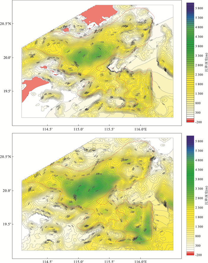
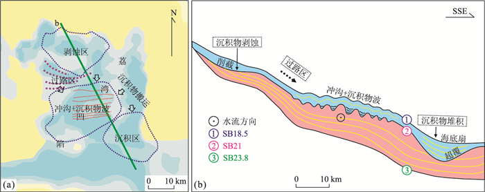
Liwan sag is an ultra deep water sag in the southernmost of the Pearl River Mouth Basin (PRMB), whose structural characteristics and sedimentary process is the important part of passive margin evolution. Using seismic stratigraphy, structures and sedimentation analysis were carried out on high-resolution 2D/3D seismic data in the Liwan Sag of the PRMB. A significant geological boundary with obvious characteristics in the Zhujiang Formation could be identified and traced—SB21. Above the sequence boundary, four types of deposition were identified: the denudation zone in the north, the sediment passing zone in the central-north, the superimposition zone of sediment waves over gulliesin the central-south, the sediment accumulation zone in the South. It's suggested that the various depositional pattern has a close relationship with the tectonic movement—Baiyun Movement—which happened in 23.8 Ma. The tectonic movement caused the differential subsidence of Liwan Sag. Accelerated subsidence happened in the central and south of the sag, and the relative uplift in the north and east. The former sedimentation equilibrium was destroyed and led to redistribution of the sediments. Sediments migrate from the northern denudation zone and migrated along the passing zone and finally deposited at the accumulation zone. We inferred that the gullies which move from east to the west were related to the differential subsidence during this period. The differential subsidence caused topographic gradient change between the NS-trending uplift and the sag center. The study of the sedimentary reflection characteristics at the boundary SB21 reveals the complicated sedimentary process and its driving mechanism in ultra deep water area, which will make great contibution to the tectonic sedimentary process in larger areas.
Liwan sag is an ultra deep water sag in the southernmost of the Pearl River Mouth Basin (PRMB), whose structural characteristics and sedimentary process is the important part of passive margin evolution. Using seismic stratigraphy, structures and sedimentation analysis were carried out on high-resolution 2D/3D seismic data in the Liwan Sag of the PRMB. A significant geological boundary with obvious characteristics in the Zhujiang Formation could be identified and traced—SB21. Above the sequence boundary, four types of deposition were identified: the denudation zone in the north, the sediment passing zone in the central-north, the superimposition zone of sediment waves over gulliesin the central-south, the sediment accumulation zone in the South. It's suggested that the various depositional pattern has a close relationship with the tectonic movement—Baiyun Movement—which happened in 23.8 Ma. The tectonic movement caused the differential subsidence of Liwan Sag. Accelerated subsidence happened in the central and south of the sag, and the relative uplift in the north and east. The former sedimentation equilibrium was destroyed and led to redistribution of the sediments. Sediments migrate from the northern denudation zone and migrated along the passing zone and finally deposited at the accumulation zone. We inferred that the gullies which move from east to the west were related to the differential subsidence during this period. The differential subsidence caused topographic gradient change between the NS-trending uplift and the sag center. The study of the sedimentary reflection characteristics at the boundary SB21 reveals the complicated sedimentary process and its driving mechanism in ultra deep water area, which will make great contibution to the tectonic sedimentary process in larger areas.


2016, 41(3): 487-498.
doi: 10.3799/dqkx.2016.040
Abstract:
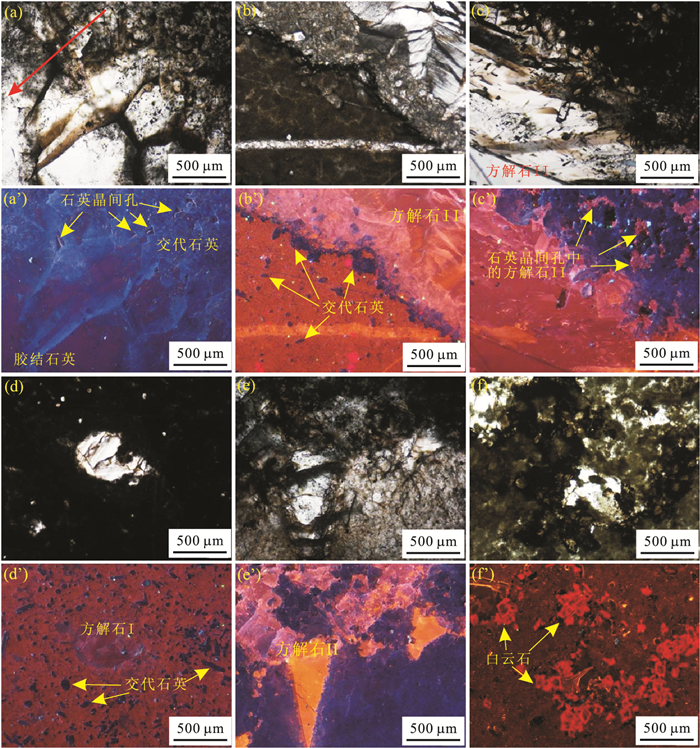
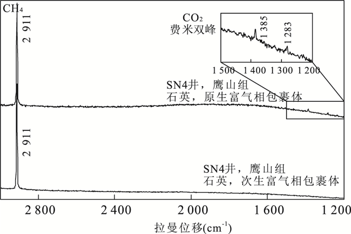
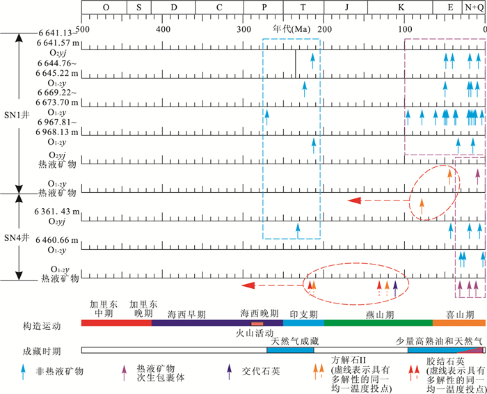
Natural gas allumulation has become one of the hot spots in the current research. In this paper, 44 samples of the Ordovician in Shunnan area have been employed to make diagenetic observation, fluid inclusions measurement, carbon and oxygen isotope measurement and Raman spectrum, aiming to recognize the hydrothermal fluid flows and speculate the time of the hydrothermal fluid flows and the accumulation of the oil and gas. The silicified limestone and the calcite, quartz cement in the cracks and caves are the products of hydrothermal fluids, accompanied with the first stage of gas accumulation during late Hercynian-Indosinian. The second stage of gas accumulation produced during Himalayan. Hydrothermal activities not only promote the gas accumulation during Hercynian, but also play a positive role in improve and preserve the reservoir spaces.
Natural gas allumulation has become one of the hot spots in the current research. In this paper, 44 samples of the Ordovician in Shunnan area have been employed to make diagenetic observation, fluid inclusions measurement, carbon and oxygen isotope measurement and Raman spectrum, aiming to recognize the hydrothermal fluid flows and speculate the time of the hydrothermal fluid flows and the accumulation of the oil and gas. The silicified limestone and the calcite, quartz cement in the cracks and caves are the products of hydrothermal fluids, accompanied with the first stage of gas accumulation during late Hercynian-Indosinian. The second stage of gas accumulation produced during Himalayan. Hydrothermal activities not only promote the gas accumulation during Hercynian, but also play a positive role in improve and preserve the reservoir spaces.


2016, 41(3): 499-507.
doi: 10.3799/dqkx.2016.041
Abstract:
The characteristics of saline stratum in Hengshui have always been concerned. In order to discuss the paleoenvironment and the paleoclimate in Hengshui area, grain size and pore water stable isotope (δD, δ18O) of clay collected from Hengshui saline stratum(thickness of 130 m) by drilling were analyzed. The standard deviation of sediment grain size shows that the hydrodynamic strength changed from weak to strong and then to weak, there is a deep gravel layer in 90-65 m, which reflects a strong hydrodynamic strength and a humid clime. The TDS and δ18O reflect the affect of atmospheric precipitation and human irrigation above 6 m, specially for the human irrigation. The mean value of δ18O at depth of 130-90 m is -11.5‰, and it is -12.1‰ and -10.6‰ at depth of 65-29 m and 23-0 m. The δ18O of aquifer at 90-65 m is -9.8‰, and -8.2‰ of 29-23 m. The δ18O of clay pore water is negative compared with the aquifer groundwater, reflecting that the clay pore water saves paleoenvironment information. The δ18O at depth of 65-29 m firstly increases and than decreases reflecting the temperature firstly increases and than decreases; the δ18O at depth of 65-29 m reflects a low temperature; the δ18O at depth of 23-0 m is relatively stable, but is positive overall, indicating a warm climate in Holocene.
The characteristics of saline stratum in Hengshui have always been concerned. In order to discuss the paleoenvironment and the paleoclimate in Hengshui area, grain size and pore water stable isotope (δD, δ18O) of clay collected from Hengshui saline stratum(thickness of 130 m) by drilling were analyzed. The standard deviation of sediment grain size shows that the hydrodynamic strength changed from weak to strong and then to weak, there is a deep gravel layer in 90-65 m, which reflects a strong hydrodynamic strength and a humid clime. The TDS and δ18O reflect the affect of atmospheric precipitation and human irrigation above 6 m, specially for the human irrigation. The mean value of δ18O at depth of 130-90 m is -11.5‰, and it is -12.1‰ and -10.6‰ at depth of 65-29 m and 23-0 m. The δ18O of aquifer at 90-65 m is -9.8‰, and -8.2‰ of 29-23 m. The δ18O of clay pore water is negative compared with the aquifer groundwater, reflecting that the clay pore water saves paleoenvironment information. The δ18O at depth of 65-29 m firstly increases and than decreases reflecting the temperature firstly increases and than decreases; the δ18O at depth of 65-29 m reflects a low temperature; the δ18O at depth of 23-0 m is relatively stable, but is positive overall, indicating a warm climate in Holocene.


2016, 41(3): 508-522.
doi: 10.3799/dqkx.2016.042
Abstract:
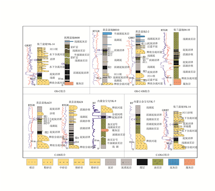
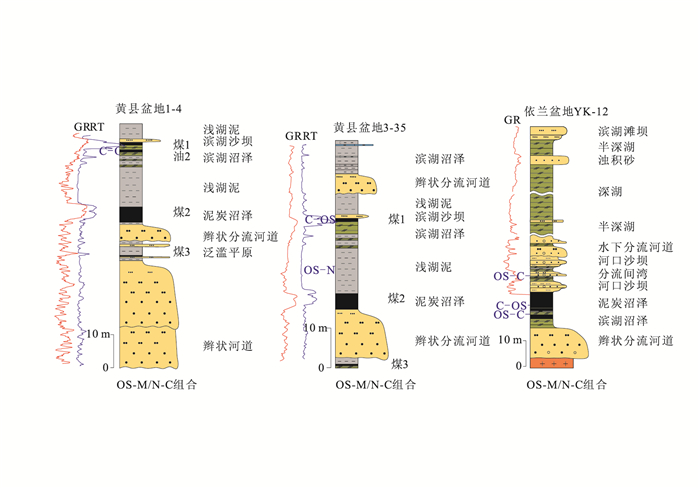
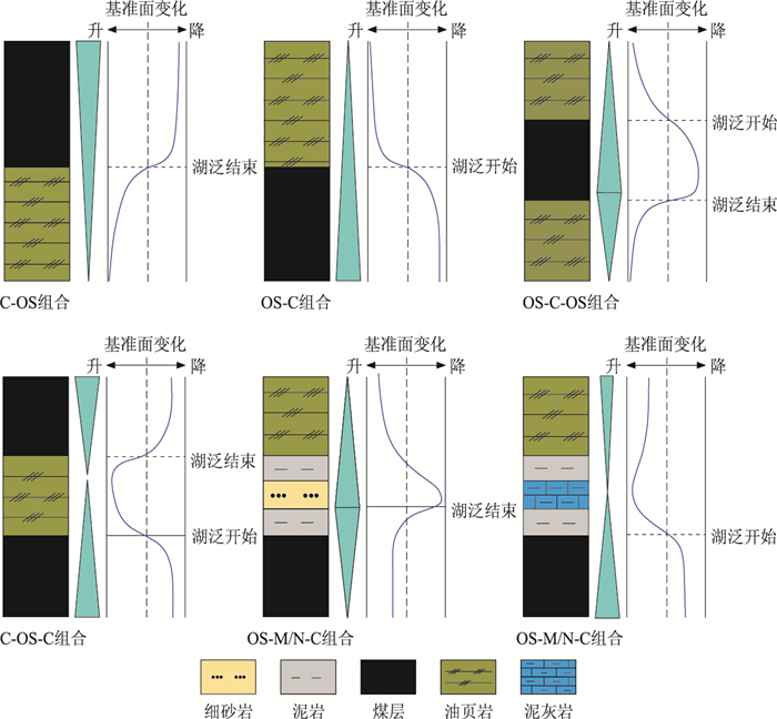
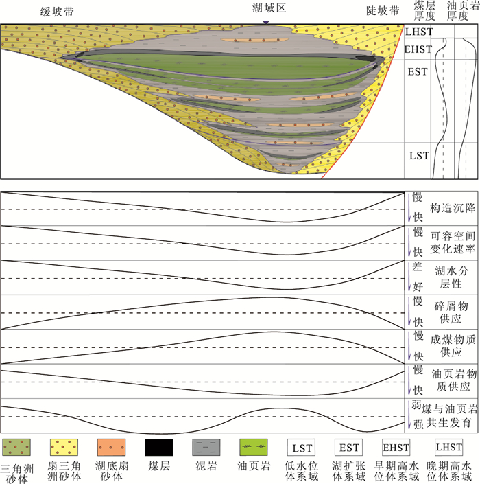
In order to research the geological phenomenon of coal and oil shale paragenetic development in continental fault basin, sedimentology, tectonics, energy geology, sequence stratigraphy related theories and methods are used for studying coal and oil shale paragenetic development characteristics. The study found that five types of coal and oil shale association exist in continental fault basin; The development of coal seam and oil shale similarly need stable tectonic and fewer terrigenous detrital material supply, and organic matter composition both contain higher plants debris and algae in paragenetic coal seam and oil shale; The basin basement episodic tectonic activity mainly controls the sedimentary environment development and evolution of coal seam and oil shale; The climate conditions, terrigenous detrital material supply and organic matter supply are secondary control effect; In sequence stratigraphic framework, all kinds of coal and oil shale symbiosis combination could developed in lake expand system tracts, from early to late, from the lakeside to center, the thickness of coal seam gradually reduce, and the thickness of the oil shale gradually increase; In early high water system tracts, the large thickness and stable distribution of oil shale and coal paragenetic assemblage was mainly developed. Visible, the factors of basin basement episodic tectonic activity, sedimentary environment evolution, climate condition, terrigenous detrital material supply, organic matter supply factors collectively control the coal and oil shale paragenetic development characteristics in continental fault basin, and those paragenetic assemblage mainly appear in lake expand system tracts and early high water system tracts.
In order to research the geological phenomenon of coal and oil shale paragenetic development in continental fault basin, sedimentology, tectonics, energy geology, sequence stratigraphy related theories and methods are used for studying coal and oil shale paragenetic development characteristics. The study found that five types of coal and oil shale association exist in continental fault basin; The development of coal seam and oil shale similarly need stable tectonic and fewer terrigenous detrital material supply, and organic matter composition both contain higher plants debris and algae in paragenetic coal seam and oil shale; The basin basement episodic tectonic activity mainly controls the sedimentary environment development and evolution of coal seam and oil shale; The climate conditions, terrigenous detrital material supply and organic matter supply are secondary control effect; In sequence stratigraphic framework, all kinds of coal and oil shale symbiosis combination could developed in lake expand system tracts, from early to late, from the lakeside to center, the thickness of coal seam gradually reduce, and the thickness of the oil shale gradually increase; In early high water system tracts, the large thickness and stable distribution of oil shale and coal paragenetic assemblage was mainly developed. Visible, the factors of basin basement episodic tectonic activity, sedimentary environment evolution, climate condition, terrigenous detrital material supply, organic matter supply factors collectively control the coal and oil shale paragenetic development characteristics in continental fault basin, and those paragenetic assemblage mainly appear in lake expand system tracts and early high water system tracts.


2016, 41(3): 523-532.
doi: 10.3799/dqkx.2016.043
Abstract:
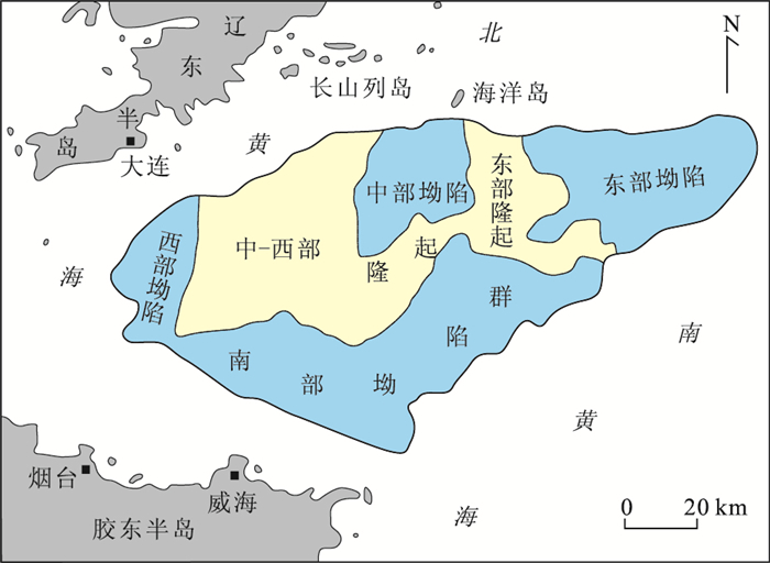
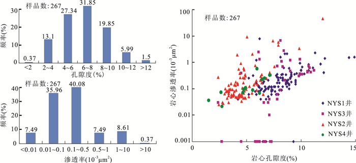
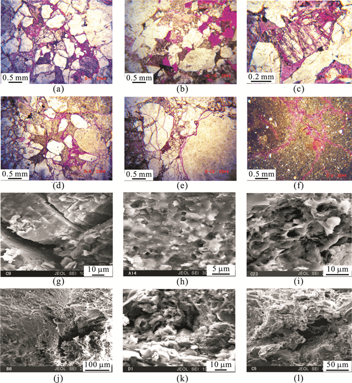
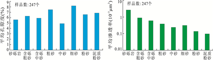
North Yellow Sea Basin is a typical Meso-Cenozoic superimposed fault basin, which has undergone few exploration and research in the offshore of China. The sandstone reservoirs of Lower Crataceous are the main exploration targets, but reservoirs tightness is the "bottleneck" which restricts the exploration activity in North Yellow Sea Basin. By core observation, thin section analysis, scanning scanning electron microscope observation, mercury penetration analysis, porosity and permeability statistics, the reservoirs characteristics of Lower Crataceous in eastern depression in North Yellow Sea Basin were researched in this paper. According to deposition, diagenesis, burial history, and so on, the origin mechanism of tightness of the reservoirs was analyzed. The results show that the sedimentary facies type of reservoirs is mainly fan delta. Reservoir physical properties are poor, belonging to extra-low porosity and extra-low permeability tight sandstone reservoirs. Main reservoir spaces are corrosion pores between grains or in grains and a few micro-fractures. The reservoir belongs to dual porosity reservoirs with pores and fractures, and the pore structure is complex. The reservoirs characteristics are controlled by sedimentary facies zone, diagenesis and burial history. The reservoir lithology is mainly feldspathic lithic sandstone and lithic feldspathic sandstone, which have medium textural maturity and compositional maturity, resulting in poor initial reservoir quality. The high content of plastic debris is not conducive to the preservation of primary porosity. The grain size of sediment affects the development of micro-fractures. The diagenesis predominates in the reservoirs tightness. The diagenetic process is decided by the burial history, which includes early deep burial, middle uplift denudation, and later deep burial. The reservoirs tightness is mainly caused by intense compaction in early phase and cementation in later phase, such as quartz increase, calcite cementation, and spontaneous mineral crystal. Feldspar corrosion and inverting kaolinite facilitate the formation of secondary porosity. The late of hydrocarbon injection causes the weak acid fluid activity, which inhibits dissolution. Fractures without displacement in later phase improve partly the reservoir property.
North Yellow Sea Basin is a typical Meso-Cenozoic superimposed fault basin, which has undergone few exploration and research in the offshore of China. The sandstone reservoirs of Lower Crataceous are the main exploration targets, but reservoirs tightness is the "bottleneck" which restricts the exploration activity in North Yellow Sea Basin. By core observation, thin section analysis, scanning scanning electron microscope observation, mercury penetration analysis, porosity and permeability statistics, the reservoirs characteristics of Lower Crataceous in eastern depression in North Yellow Sea Basin were researched in this paper. According to deposition, diagenesis, burial history, and so on, the origin mechanism of tightness of the reservoirs was analyzed. The results show that the sedimentary facies type of reservoirs is mainly fan delta. Reservoir physical properties are poor, belonging to extra-low porosity and extra-low permeability tight sandstone reservoirs. Main reservoir spaces are corrosion pores between grains or in grains and a few micro-fractures. The reservoir belongs to dual porosity reservoirs with pores and fractures, and the pore structure is complex. The reservoirs characteristics are controlled by sedimentary facies zone, diagenesis and burial history. The reservoir lithology is mainly feldspathic lithic sandstone and lithic feldspathic sandstone, which have medium textural maturity and compositional maturity, resulting in poor initial reservoir quality. The high content of plastic debris is not conducive to the preservation of primary porosity. The grain size of sediment affects the development of micro-fractures. The diagenesis predominates in the reservoirs tightness. The diagenetic process is decided by the burial history, which includes early deep burial, middle uplift denudation, and later deep burial. The reservoirs tightness is mainly caused by intense compaction in early phase and cementation in later phase, such as quartz increase, calcite cementation, and spontaneous mineral crystal. Feldspar corrosion and inverting kaolinite facilitate the formation of secondary porosity. The late of hydrocarbon injection causes the weak acid fluid activity, which inhibits dissolution. Fractures without displacement in later phase improve partly the reservoir property.

2016, 41(3): 533-545.
doi: 10.3799/dqkx.2016.044
Abstract:
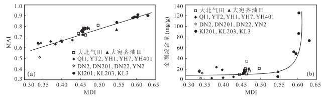
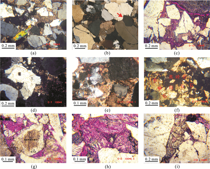
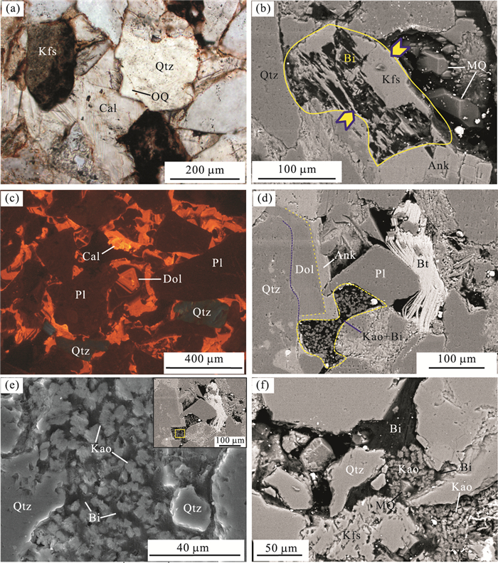
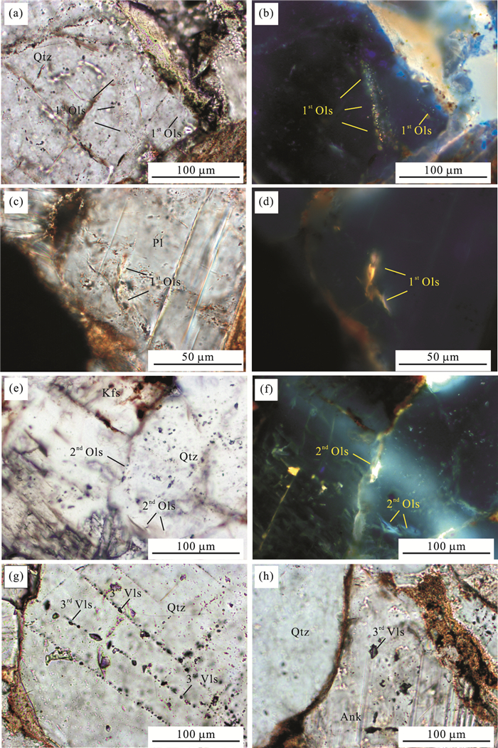
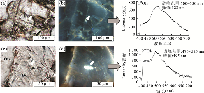
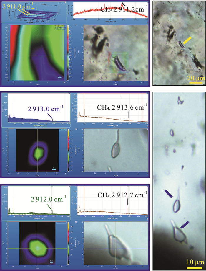
The Kela-2 gas field is the most productive gas field in China. The lower Cretaceous Bashenjiqike Formation (K1bs) are the dominated gas-bearing strata. Characterization of the diagenetic history, different fluid inclusion assemblages and the effects of oil emplacement on diagenetic processes of the K1bs in the Kuqa Depression, Tarim Basin have been studied using a combination of techniques such as polarizing microscope, cathode luminescence (CL), scanning electron microscope (SEM), CT three-dimensional reconstruction, X-ray diffraction (XRD), fluorescence spectroscopy, microthermometry, and Raman microspectroscopy. Diagenetic events identify include quartz overgrowths, early calcite cements, dolomite cements, ankerite cements, micro-quartz and authigenic kaolinite. Three episodes of oil emplacement are recorded by the diagenetic products in the K1bs Formations. The first episode consists of the yellowish-brown fluorescent petroleum inclusions hosted in the transgranular fractures, cleavage plans of the feldspar and calcite cements, paired with low trapped temperature and relatively high salinity, forming around 18 Ma; the second episode consists of the yellow-white to blue-white petroleum inclusions located in the transgranular fractures, boundary of quartz particles and dolomite cements, paired with high trapped temperature and high salinity, forming around 6 Ma; the third episode consists of the CH4-bearing vapour inclusions within the annealed microfractures and ankerite cements, having with high trapped temperature and low salinity, forming around 4 Ma. Authigenic kaolinite, micor-quartz and solid bitumen are the results transformed by the advanced natural gas charge.
The Kela-2 gas field is the most productive gas field in China. The lower Cretaceous Bashenjiqike Formation (K1bs) are the dominated gas-bearing strata. Characterization of the diagenetic history, different fluid inclusion assemblages and the effects of oil emplacement on diagenetic processes of the K1bs in the Kuqa Depression, Tarim Basin have been studied using a combination of techniques such as polarizing microscope, cathode luminescence (CL), scanning electron microscope (SEM), CT three-dimensional reconstruction, X-ray diffraction (XRD), fluorescence spectroscopy, microthermometry, and Raman microspectroscopy. Diagenetic events identify include quartz overgrowths, early calcite cements, dolomite cements, ankerite cements, micro-quartz and authigenic kaolinite. Three episodes of oil emplacement are recorded by the diagenetic products in the K1bs Formations. The first episode consists of the yellowish-brown fluorescent petroleum inclusions hosted in the transgranular fractures, cleavage plans of the feldspar and calcite cements, paired with low trapped temperature and relatively high salinity, forming around 18 Ma; the second episode consists of the yellow-white to blue-white petroleum inclusions located in the transgranular fractures, boundary of quartz particles and dolomite cements, paired with high trapped temperature and high salinity, forming around 6 Ma; the third episode consists of the CH4-bearing vapour inclusions within the annealed microfractures and ankerite cements, having with high trapped temperature and low salinity, forming around 4 Ma. Authigenic kaolinite, micor-quartz and solid bitumen are the results transformed by the advanced natural gas charge.


2016, 41(3): 546-554.
doi: 10.3799/dqkx.2016.045
Abstract:
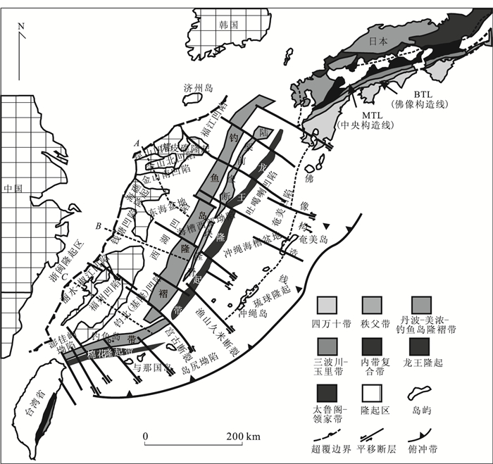
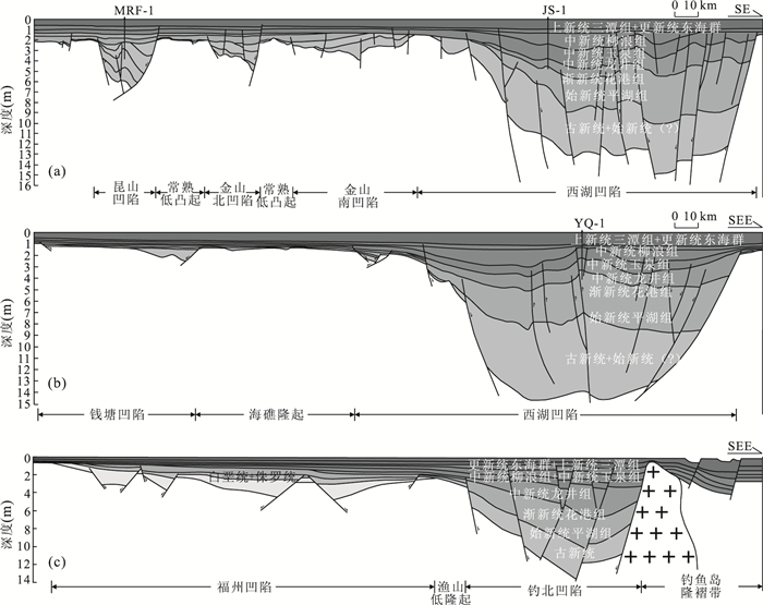
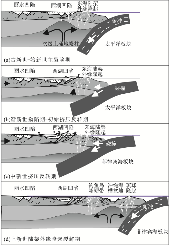
The East China Sea Basin that located in the front of the west Pacific subduction zone, is formed upon the Huanan Craton basement. The main sediment filling are from Late Cretaceous to Cenozoic. The East China Sea Basin developed on the thinned continental margin crust, is a back-arc rift basin caused by rifting and stretching that induced by ocean subduction, which is the part of the "trench-arc-basin" system in the west Pacific. The tectonic evolution was controlled by the uplift in the outer continental shelf that formed in the Late Cretaceous. The uplift is the complex of the continental margin uplift and accretionary wedge that disintegrated into Diaoyu Island fold belt and Ryukyu uplift after Miocene. Considering the study of the outer continental shelf uplift, tectonic evolution history of the East China Sea basin after Late Cretaceous can be divided into three stages: the first stage, the Paleocene to Middle Late Eocene, formation and development of the western depression; the second stage, Middle Late Eocene to Oligocene, formation and development of the eastern depression, in which the rotary of the Pacific plate boundary in the Middle Late Eocene is the demarcation point of the tectonic migration of the eastern depression and western depression; the third stage, Miocene-Holocene, impaction of the Philippine Sea Plate period, the original structure pattern of the East China Sea Basin began to decompose.
The East China Sea Basin that located in the front of the west Pacific subduction zone, is formed upon the Huanan Craton basement. The main sediment filling are from Late Cretaceous to Cenozoic. The East China Sea Basin developed on the thinned continental margin crust, is a back-arc rift basin caused by rifting and stretching that induced by ocean subduction, which is the part of the "trench-arc-basin" system in the west Pacific. The tectonic evolution was controlled by the uplift in the outer continental shelf that formed in the Late Cretaceous. The uplift is the complex of the continental margin uplift and accretionary wedge that disintegrated into Diaoyu Island fold belt and Ryukyu uplift after Miocene. Considering the study of the outer continental shelf uplift, tectonic evolution history of the East China Sea basin after Late Cretaceous can be divided into three stages: the first stage, the Paleocene to Middle Late Eocene, formation and development of the western depression; the second stage, Middle Late Eocene to Oligocene, formation and development of the eastern depression, in which the rotary of the Pacific plate boundary in the Middle Late Eocene is the demarcation point of the tectonic migration of the eastern depression and western depression; the third stage, Miocene-Holocene, impaction of the Philippine Sea Plate period, the original structure pattern of the East China Sea Basin began to decompose.