


2016 Vol. 41, No. 5
Display Method:
 PDF 240KB
2016, 41(5): 729-741.
doi: 10.3799/dqkx.2016.062
Abstract:
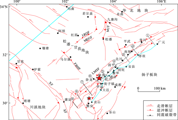
Study on transverse faults in the Longmenshan fault zone is inadequate so far. Based on the regional geology, gravity data, magnetic data, distribution of earthquake and velocity data, combined with field study and structural modeling, the genetic types and geological significances of transverse faults at the Longmenshan fault zone were studied. It is found that: (1) There are 6 transverse faults in the northern and central Longmenshan fault zone, namely, the Bailongjiang, Nanba, Huya, Qingping, Xiaoyudong and Wolong-Huaiyuan transverse faults, where Huya fault is the boundary between the northern and central Longmenshan fault zones, while the Wolong-Huaiyuan fault is between the southern and central Longmenshan fault zone; (2) Transverse faults mainly have three genetic types, they are the transfer faults resulted from the reaction of the pre-existing NW-trending faults or weak belts and the nonsynchronous movement of the thrust faults, X-type conjugate shear faults and transverse extensional faults; (3) Transverse faults cut the Longmenshan fault zone into several segments and transfer the differences of the stratum, the geomorphology, the movement intensity, width of the thrust belts, earthquake intensity and frequency of different segments, besides, transverse faults could be independent seismogenic faults which may trigger earthquakes with the Longmenshan major fault belts and restrict the spread of aftershocks.
Study on transverse faults in the Longmenshan fault zone is inadequate so far. Based on the regional geology, gravity data, magnetic data, distribution of earthquake and velocity data, combined with field study and structural modeling, the genetic types and geological significances of transverse faults at the Longmenshan fault zone were studied. It is found that: (1) There are 6 transverse faults in the northern and central Longmenshan fault zone, namely, the Bailongjiang, Nanba, Huya, Qingping, Xiaoyudong and Wolong-Huaiyuan transverse faults, where Huya fault is the boundary between the northern and central Longmenshan fault zones, while the Wolong-Huaiyuan fault is between the southern and central Longmenshan fault zone; (2) Transverse faults mainly have three genetic types, they are the transfer faults resulted from the reaction of the pre-existing NW-trending faults or weak belts and the nonsynchronous movement of the thrust faults, X-type conjugate shear faults and transverse extensional faults; (3) Transverse faults cut the Longmenshan fault zone into several segments and transfer the differences of the stratum, the geomorphology, the movement intensity, width of the thrust belts, earthquake intensity and frequency of different segments, besides, transverse faults could be independent seismogenic faults which may trigger earthquakes with the Longmenshan major fault belts and restrict the spread of aftershocks.


2016, 41(5): 742-756.
doi: 10.3799/dqkx.2016.063
Abstract:
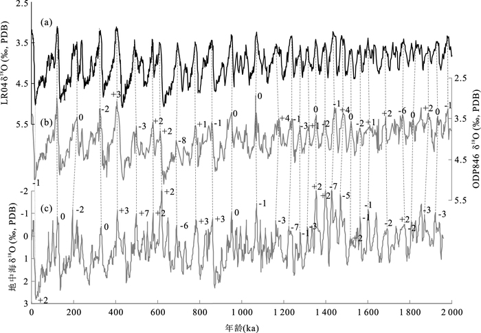
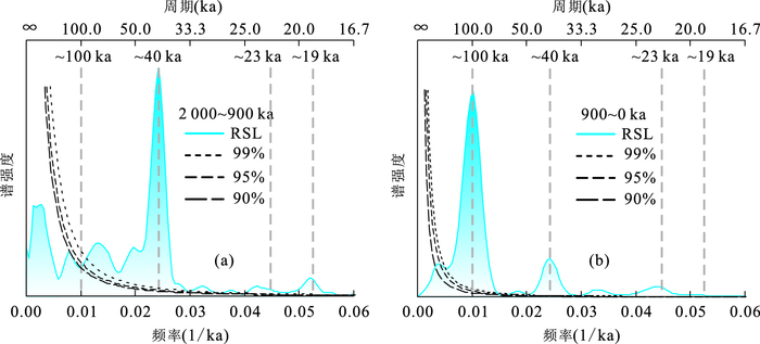
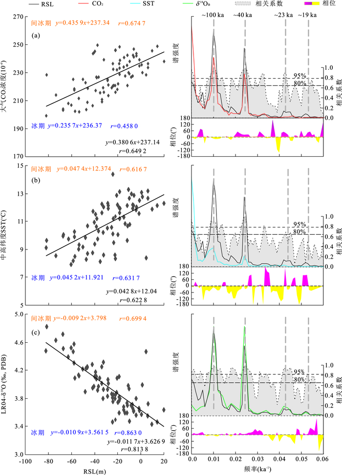
Sea level change usually has great impact on global (or regional) ecological environment and social economy. Based on the published records of relative sea level (RSL), one new stacked RSL is reconstructed in this paper, and the correlations between the new stacked RSL and original records are analyzed. In addition, the reliability and rationality of the new stacked RSL are tested and verified respectively by Spectrum and Filtering analysis. Furthermore, the evolutionary history and correlations between the stacked RSL and atmospheric CO2 concentration, sea surface temperature (SST) in middle-high latitudinal oceans and benthic oxygen isotope (δ18OB) record are separately discussed in detail. The results show that: (1) the new stacked RSL has the similar change trend to the original RSL records during the last 2 Ma BP, and the correlation coefficients are all nearly 0.9. Meanwhile, the new stacked RSL also responds well to the global climate change events at the earth orbital parameter cycles; (2) The new stacked RSL and LR04-δ18OB have high negative correlation in glacial-interglacial cycles during the last 2 Ma BP, with the correlation coefficient of about 0.81, which is much higher than those of the new stacked RSL with SST and atmospheric CO2 concentration; (3) Based on the cross-spectral analytical results between the new stacked RSL and CO2, SST and δ18OB, individually, the new stacked RSL is nearly in phase with δ18OB, and both lags SST and CO2 at the eccentricity band, and lags SST but leads CO2 at the obliquity band. It is concluded that the polar ice sheet volume was influenced by changes of SST and atmospheric CO2 concentration, which might be caused by the change of solar insolation and finally influenced the sea level change at the earth orbital parameter cycles.
Sea level change usually has great impact on global (or regional) ecological environment and social economy. Based on the published records of relative sea level (RSL), one new stacked RSL is reconstructed in this paper, and the correlations between the new stacked RSL and original records are analyzed. In addition, the reliability and rationality of the new stacked RSL are tested and verified respectively by Spectrum and Filtering analysis. Furthermore, the evolutionary history and correlations between the stacked RSL and atmospheric CO2 concentration, sea surface temperature (SST) in middle-high latitudinal oceans and benthic oxygen isotope (δ18OB) record are separately discussed in detail. The results show that: (1) the new stacked RSL has the similar change trend to the original RSL records during the last 2 Ma BP, and the correlation coefficients are all nearly 0.9. Meanwhile, the new stacked RSL also responds well to the global climate change events at the earth orbital parameter cycles; (2) The new stacked RSL and LR04-δ18OB have high negative correlation in glacial-interglacial cycles during the last 2 Ma BP, with the correlation coefficient of about 0.81, which is much higher than those of the new stacked RSL with SST and atmospheric CO2 concentration; (3) Based on the cross-spectral analytical results between the new stacked RSL and CO2, SST and δ18OB, individually, the new stacked RSL is nearly in phase with δ18OB, and both lags SST and CO2 at the eccentricity band, and lags SST but leads CO2 at the obliquity band. It is concluded that the polar ice sheet volume was influenced by changes of SST and atmospheric CO2 concentration, which might be caused by the change of solar insolation and finally influenced the sea level change at the earth orbital parameter cycles.


2016, 41(5): 757-764.
doi: 10.3799/dqkx.2016.064
Abstract:
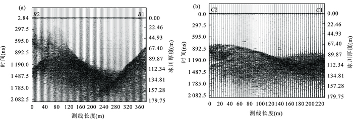
Ice bedrock topographic map and ice volume estimation play very important parts in glacier melt water research. Muz Taw glacier in Sawir Mountains was explored in this study by means of Landsat remote sensing image, digital elevation model data, ground penetrating radar (GPR) data and GPS positioning data. Its terminus thickness distribution was obtained by analysis and simulation of thickness distribution of its transverse and vertical sections, combined with a variety of interpolation methods, on basis of which the ice volume was estimated. Results show obvious differences between the two transverse profiles. Cross-section B1-B2 has typical "U"-type terrain, with maximum glacier thickness of up to 116.4 m; cross-section C1-C2 is relatively flat, and glacier thickness distribution is more uniform, with an average of about 70-90 m. In longitudinal profile, A1-A2 forms a ladder-like distribution, with an obvious depression in the middle of the ice bed topography. The average ice thickness in longitudinal profile is about 80.89 m, with maximum ice thickness of 122.67 m. The ice bed topographic map is in sharp contrast with the thickness contour map of the glacier. In addition, there is obvious cirque terrain at an altitude of 3 240 m and 3 280 m. The preliminary estimation of the average thickness and total terminus ice volume are approximately 60.5 m and 0.195 km3, respectively. It is concluded that GPR method has higher accuracy compared with the traditional ice volume estimation method, but it has restrictions because of measurement difficulties
Ice bedrock topographic map and ice volume estimation play very important parts in glacier melt water research. Muz Taw glacier in Sawir Mountains was explored in this study by means of Landsat remote sensing image, digital elevation model data, ground penetrating radar (GPR) data and GPS positioning data. Its terminus thickness distribution was obtained by analysis and simulation of thickness distribution of its transverse and vertical sections, combined with a variety of interpolation methods, on basis of which the ice volume was estimated. Results show obvious differences between the two transverse profiles. Cross-section B1-B2 has typical "U"-type terrain, with maximum glacier thickness of up to 116.4 m; cross-section C1-C2 is relatively flat, and glacier thickness distribution is more uniform, with an average of about 70-90 m. In longitudinal profile, A1-A2 forms a ladder-like distribution, with an obvious depression in the middle of the ice bed topography. The average ice thickness in longitudinal profile is about 80.89 m, with maximum ice thickness of 122.67 m. The ice bed topographic map is in sharp contrast with the thickness contour map of the glacier. In addition, there is obvious cirque terrain at an altitude of 3 240 m and 3 280 m. The preliminary estimation of the average thickness and total terminus ice volume are approximately 60.5 m and 0.195 km3, respectively. It is concluded that GPR method has higher accuracy compared with the traditional ice volume estimation method, but it has restrictions because of measurement difficulties


2016, 41(5): 765-778.
doi: 10.3799/dqkx.2016.065
Abstract:
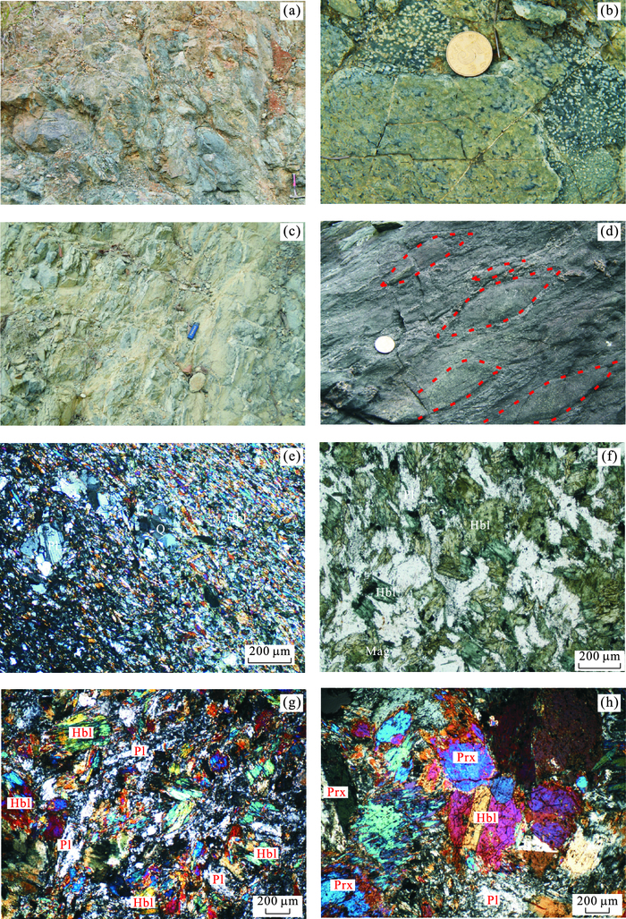
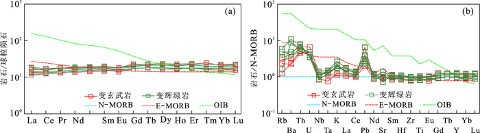
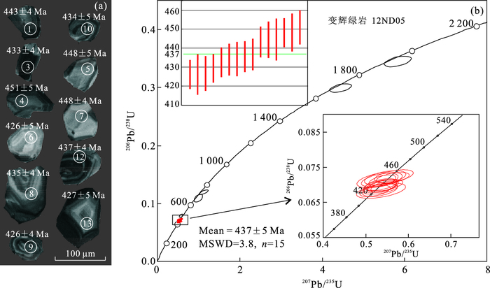
The nature of Early Paleozoic Caledonian orogeny (Guangxi movement), as one of the key geolocial problems of tectonic evolution in South China, has been controversial for a long time. In this study we report a suite of deformed and metamorphosed basic rocks in tectonic slices that are exposed in epimetamorphic Ordovician strata, located at the Nuodong in the Cenxi area of the Southeast Guangxi, South China. This suite of rock is mainly composed of metamorphic basalt, diabase dike and minor pyroxenite. Petrogeochemical data of the metabasalt and metadiabase dike show the content of SiO2=49.20%-52.30%, MgO=6.78%-9.11%, Mg#=55-63, TiO2=1.02%-1.34%, indicating the low potassium tholeiitic series of basic rocks. The chondrite-normalized REE distribution patterns are flat type with light rare earths depleted, no obvious Eu anomaly, (La/Sm)N=0.72-1.05, (La/Yb)N=0.7-1.0, while the N-MORB normalized spider diagrams show slightly enrichment of LILEs (e.g.Rb, Ba, Th, U, K, Pb) and flat-slightly depletion of HFSEs (e.g.Nb, Ta, Zr, Hf, Ti), Ti/V=21.30-25.12, Nb/Th=2.1-4.2. The geological and petrogeochemical features imply that this series of rocks represent a dismembered ophiolites formed in supra-subduction zone (SSZ) tectonic environment.The LA-ICP-MS zircon U-Pb age of the metadiabase is 437±5 Ma, indicating that the ophiolites were formed at the Early Silurian. Based on the above comprehensive study, we propose that the Nuodong metamorphic basic rock series are Early Paleozoic ophiolite fragments formed in a forearc tectonic environment in a supra-subduction zone (SSZ). The document of the Early Paleozoic Nuodong ophiolite provides key evidence for the existence of an Early Paleozoic oceanic basin and subduction-accretionary collisional orogenesis between Yangtze craton and Cathaysia blocks in South China.
The nature of Early Paleozoic Caledonian orogeny (Guangxi movement), as one of the key geolocial problems of tectonic evolution in South China, has been controversial for a long time. In this study we report a suite of deformed and metamorphosed basic rocks in tectonic slices that are exposed in epimetamorphic Ordovician strata, located at the Nuodong in the Cenxi area of the Southeast Guangxi, South China. This suite of rock is mainly composed of metamorphic basalt, diabase dike and minor pyroxenite. Petrogeochemical data of the metabasalt and metadiabase dike show the content of SiO2=49.20%-52.30%, MgO=6.78%-9.11%, Mg#=55-63, TiO2=1.02%-1.34%, indicating the low potassium tholeiitic series of basic rocks. The chondrite-normalized REE distribution patterns are flat type with light rare earths depleted, no obvious Eu anomaly, (La/Sm)N=0.72-1.05, (La/Yb)N=0.7-1.0, while the N-MORB normalized spider diagrams show slightly enrichment of LILEs (e.g.Rb, Ba, Th, U, K, Pb) and flat-slightly depletion of HFSEs (e.g.Nb, Ta, Zr, Hf, Ti), Ti/V=21.30-25.12, Nb/Th=2.1-4.2. The geological and petrogeochemical features imply that this series of rocks represent a dismembered ophiolites formed in supra-subduction zone (SSZ) tectonic environment.The LA-ICP-MS zircon U-Pb age of the metadiabase is 437±5 Ma, indicating that the ophiolites were formed at the Early Silurian. Based on the above comprehensive study, we propose that the Nuodong metamorphic basic rock series are Early Paleozoic ophiolite fragments formed in a forearc tectonic environment in a supra-subduction zone (SSZ). The document of the Early Paleozoic Nuodong ophiolite provides key evidence for the existence of an Early Paleozoic oceanic basin and subduction-accretionary collisional orogenesis between Yangtze craton and Cathaysia blocks in South China.


2016, 41(5): 779-791.
doi: 10.3799/dqkx.2016.066
Abstract:
To explore the law of carbonate dissolution evolution to facilitate oil and gas exploration, the dissolution process and kinetic mechanisms of oolitic limestone and oolitic dolomite in sulfuric acid medium under normal temperatures are discussed in the paper. In-situ micromorphology of the reaction surface was observed by environmental scanning electron microscope (ESEM) and the elemental distribution was analyzed by fractal and multifractal theory using the X-ray mapping capabilities of the ESEM. The different dissolutions observed in the experiment indicate that the dissolution of the mineral starts at points of structure defects (as cleavage or fracture), and that the dissolution rate of oolitic limestone at the point with high Ca content is faster than that with low Ca or high Si content, which results in an uneven corrosion pits and pore spaces formed on the reaction surface. Moreover, the sulfuric acid cracks the ooid dolomite into granular and intergranular fractures and pore space in or between particles. Analysis of the weight loss by dissolution of thin section shows that the weight loss of oolitic dolomite is about 80% higher than that of oolitic limestone, indicating that the sulfuric acid has a stronger dissolution ability for oolitic dolomite. It is found by micromorphology observation that the granular surface of oolitic dolomite formed by sulfuric acid dissolution is more conducive to deepening of dissolution, which further improves development of pore space and connectivity. The fractal and multifractal analyses indicate that the dissolution process is controlled by differences between the element distribution heterogeneity of Ca, Mg and Si. Additionally, large difference of composition, strong heterogeneity of element distribution can promote the dissolution reaction.
To explore the law of carbonate dissolution evolution to facilitate oil and gas exploration, the dissolution process and kinetic mechanisms of oolitic limestone and oolitic dolomite in sulfuric acid medium under normal temperatures are discussed in the paper. In-situ micromorphology of the reaction surface was observed by environmental scanning electron microscope (ESEM) and the elemental distribution was analyzed by fractal and multifractal theory using the X-ray mapping capabilities of the ESEM. The different dissolutions observed in the experiment indicate that the dissolution of the mineral starts at points of structure defects (as cleavage or fracture), and that the dissolution rate of oolitic limestone at the point with high Ca content is faster than that with low Ca or high Si content, which results in an uneven corrosion pits and pore spaces formed on the reaction surface. Moreover, the sulfuric acid cracks the ooid dolomite into granular and intergranular fractures and pore space in or between particles. Analysis of the weight loss by dissolution of thin section shows that the weight loss of oolitic dolomite is about 80% higher than that of oolitic limestone, indicating that the sulfuric acid has a stronger dissolution ability for oolitic dolomite. It is found by micromorphology observation that the granular surface of oolitic dolomite formed by sulfuric acid dissolution is more conducive to deepening of dissolution, which further improves development of pore space and connectivity. The fractal and multifractal analyses indicate that the dissolution process is controlled by differences between the element distribution heterogeneity of Ca, Mg and Si. Additionally, large difference of composition, strong heterogeneity of element distribution can promote the dissolution reaction.


2016, 41(5): 792-808.
doi: 10.3799/dqkx.2016.067
Abstract:
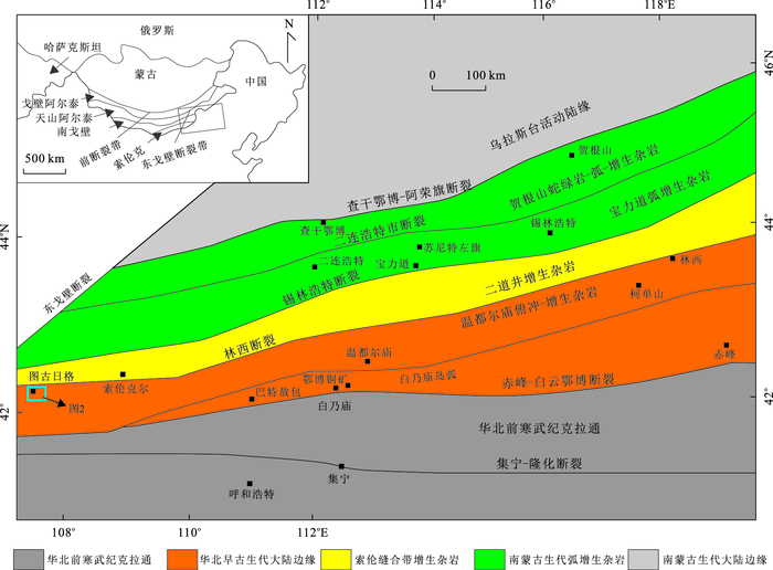
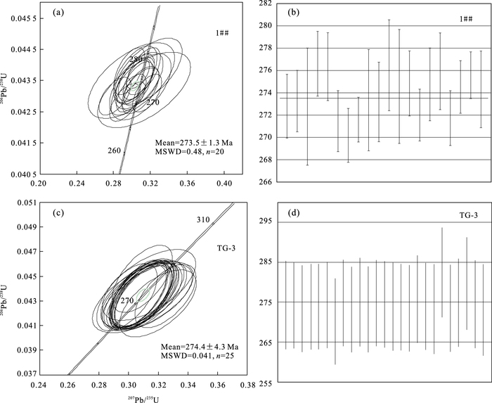
Electron microprobe results, zircon U-Pb dating, Hf isotope data and geochemistry of hornblendite at Tugurige, Urad Zhongqi, Inner Mongolia are reported in the paper, which provide constraints on formation time, magma source, and tectonic setting of the intrusions. The dating results indicate that the hornblendite formed in the late Early Permian (273.5±1.3 Ma, MSWD=0.48; 274.4±4.3 Ma, MSWD=0.041), and it contains low Na2O and K2O, high Al2O3, TFe2O3, MgO, CaO, Mg#=46.95-63.53, M/F=0.87-1.72. Chondrite-normalized REE patterns show LREE enrichment. On a trace element spider diagram, large ion lithophile elements (LILEs) such as Rb, Ba and K are enriched, whereas the high field strength elements Ti, P, Th and U are relatively depleted. Electronic Probe analysis results show that hornblende belongs to calcic amphibole and has the characteristics of mantle hornblende. The ε Hf(t) values of zircons from the hornblendite vary between -0.3 and 8.5, and their Hf one-stage model ages vary from 580 to 920 Ma, implying that their magma source was derived from a depleted mantle and may have been added metasomatic enriched lithospheric mantle components. Combined with regional tectonic evolution, the hornblendite formed in the post-collisional extension setting, perhaps triggered by slab break-off.
Electron microprobe results, zircon U-Pb dating, Hf isotope data and geochemistry of hornblendite at Tugurige, Urad Zhongqi, Inner Mongolia are reported in the paper, which provide constraints on formation time, magma source, and tectonic setting of the intrusions. The dating results indicate that the hornblendite formed in the late Early Permian (273.5±1.3 Ma, MSWD=0.48; 274.4±4.3 Ma, MSWD=0.041), and it contains low Na2O and K2O, high Al2O3, TFe2O3, MgO, CaO, Mg#=46.95-63.53, M/F=0.87-1.72. Chondrite-normalized REE patterns show LREE enrichment. On a trace element spider diagram, large ion lithophile elements (LILEs) such as Rb, Ba and K are enriched, whereas the high field strength elements Ti, P, Th and U are relatively depleted. Electronic Probe analysis results show that hornblende belongs to calcic amphibole and has the characteristics of mantle hornblende. The ε Hf(t) values of zircons from the hornblendite vary between -0.3 and 8.5, and their Hf one-stage model ages vary from 580 to 920 Ma, implying that their magma source was derived from a depleted mantle and may have been added metasomatic enriched lithospheric mantle components. Combined with regional tectonic evolution, the hornblendite formed in the post-collisional extension setting, perhaps triggered by slab break-off.


2016, 41(5): 809-820.
doi: 10.3799/dqkx.2016.068
Abstract:
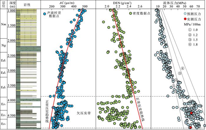
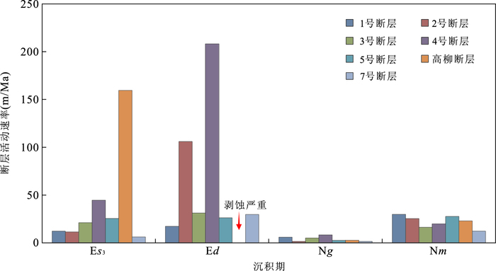
This article aims to discuss the evolution of genetic mechanisms of overpressure, based on the numerical situation technique to recover the paleopressure formation and evolution, and combined with the evolution of sedimentation rate, hydrocarbon generation and porosity. And further study the accumulation significance of pressure evolution. The forward modeling indicates that the overpressure evolution in the sag is divided into three stages: original forming (before the erosion of Dongying Formation), release (during the erosion of Dongying Formation) and reform (since the end of Dongying Formation). Compaction disequilibrium is the main cause of overpressure before the erosion of Dongying Formation, which is beneficial to hydrocarbon emission. Overpressure release occurred during the erosion of Dongying Formation, which leads to the early reservoir adjustment to a certain extent. Hydrocarbon generation is the main cause of overpressure since the end of Dongying Formation, and coupling of the hydrocarbon generation, two hydrocarbon accumulation periods and fault activities played an active role in hydrocarbon accumulation. On one hand, a large quantity of hydrocarbon migrated along with fracture and sandstone to form inner-source plays. On the other hand, hydrocarbon migrated along with oil-source faults to form above-source plays under the high residual pressure difference between source rock and reservoir providing. The beneficial hydrocarbon accumulation regions are closely related to the stress distribution. Generally, the depth of oil reservoir and pressure coefficient is positive correlation under different plays of pressure coefficient distribution. The present study suggests that the future exploration would focus on higher value of pressure coefficient under different plays of pressure coefficient distribution.
This article aims to discuss the evolution of genetic mechanisms of overpressure, based on the numerical situation technique to recover the paleopressure formation and evolution, and combined with the evolution of sedimentation rate, hydrocarbon generation and porosity. And further study the accumulation significance of pressure evolution. The forward modeling indicates that the overpressure evolution in the sag is divided into three stages: original forming (before the erosion of Dongying Formation), release (during the erosion of Dongying Formation) and reform (since the end of Dongying Formation). Compaction disequilibrium is the main cause of overpressure before the erosion of Dongying Formation, which is beneficial to hydrocarbon emission. Overpressure release occurred during the erosion of Dongying Formation, which leads to the early reservoir adjustment to a certain extent. Hydrocarbon generation is the main cause of overpressure since the end of Dongying Formation, and coupling of the hydrocarbon generation, two hydrocarbon accumulation periods and fault activities played an active role in hydrocarbon accumulation. On one hand, a large quantity of hydrocarbon migrated along with fracture and sandstone to form inner-source plays. On the other hand, hydrocarbon migrated along with oil-source faults to form above-source plays under the high residual pressure difference between source rock and reservoir providing. The beneficial hydrocarbon accumulation regions are closely related to the stress distribution. Generally, the depth of oil reservoir and pressure coefficient is positive correlation under different plays of pressure coefficient distribution. The present study suggests that the future exploration would focus on higher value of pressure coefficient under different plays of pressure coefficient distribution.


2016, 41(5): 821-831.
doi: 10.3799/dqkx.2016.069
Abstract:
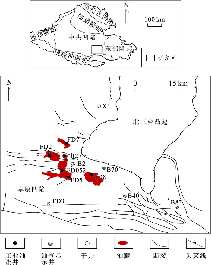
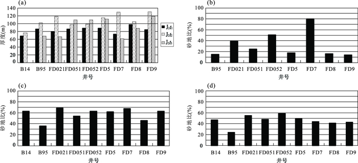
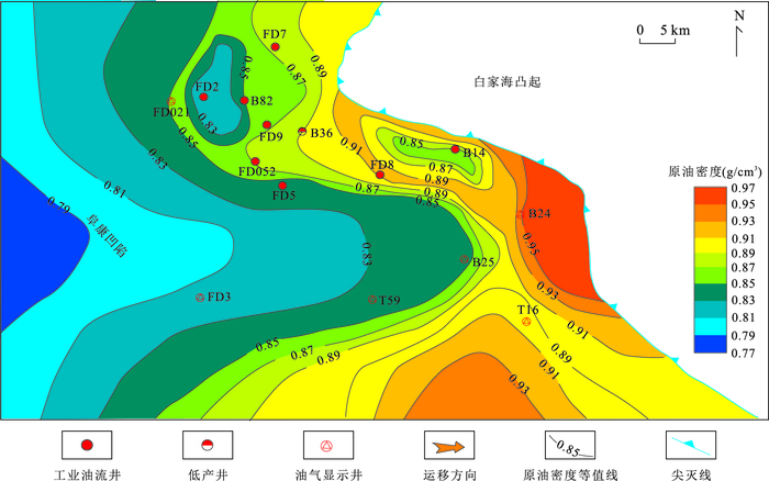
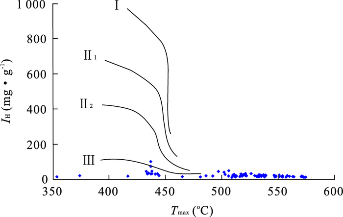
Few studies have been done on the petroleum lateral migration in the newly discovered oil reservoirs in the Jurassic Toutunhe Formation in the Fudong slope, Junggar basin. The process and mechanisms of the petroleum lateral migration of Jurassic in the Fudong slope were investigated based on the geological analysis of the strata, porosity and permeability of the reservoir rocks and geochemical study on oil-source correlation and oil-oil correlation in this study. The results indicate that hydrocarbons of the Jurassic Toutunhe Formation in Fudong slope were primarily derived from the mixing of the Middle-Lower Jurassic and Middle Permian source rocks of the western Fukang depression and migrated along the axis from west to east. The thickness, sand/strata ratio, porosity and permeability of Toutunhe 2 member are all better than those of Toutunhe 1 member, which makes it the main carrier beds of hydrocarbons lateral migration.
Few studies have been done on the petroleum lateral migration in the newly discovered oil reservoirs in the Jurassic Toutunhe Formation in the Fudong slope, Junggar basin. The process and mechanisms of the petroleum lateral migration of Jurassic in the Fudong slope were investigated based on the geological analysis of the strata, porosity and permeability of the reservoir rocks and geochemical study on oil-source correlation and oil-oil correlation in this study. The results indicate that hydrocarbons of the Jurassic Toutunhe Formation in Fudong slope were primarily derived from the mixing of the Middle-Lower Jurassic and Middle Permian source rocks of the western Fukang depression and migrated along the axis from west to east. The thickness, sand/strata ratio, porosity and permeability of Toutunhe 2 member are all better than those of Toutunhe 1 member, which makes it the main carrier beds of hydrocarbons lateral migration.


2016, 41(5): 832-842.
doi: 10.3799/dqkx.2016.070
Abstract:
The debate on formation of source rocks has been focused on "productivity mode" and "preservation mode" in marine sediments for many years. Based on the datasets of total organic carbon, carbonate carbon isotope, pyrolysis parameters and reduced sulfur of source rocks of Erlian basin, the productivity and terrigenous organic matter input are characterized and then the role of organic matter supply and preservation in the formation of source rocks are discussed. For the lacustrine basin with high organic matter supply, organic matter supply is the main factor controlling the formation on source rocks because there are still source rocks formed by accumulation of residual organic matter even in the oxidizing sedimentary environment. For the lacustrine basin with low organic matter supply, preservation is the main factor controlling the formation on source rocks because the organic matter can only be preserved in reducing environment since it is too rare to be preserved from oxidation.
The debate on formation of source rocks has been focused on "productivity mode" and "preservation mode" in marine sediments for many years. Based on the datasets of total organic carbon, carbonate carbon isotope, pyrolysis parameters and reduced sulfur of source rocks of Erlian basin, the productivity and terrigenous organic matter input are characterized and then the role of organic matter supply and preservation in the formation of source rocks are discussed. For the lacustrine basin with high organic matter supply, organic matter supply is the main factor controlling the formation on source rocks because there are still source rocks formed by accumulation of residual organic matter even in the oxidizing sedimentary environment. For the lacustrine basin with low organic matter supply, preservation is the main factor controlling the formation on source rocks because the organic matter can only be preserved in reducing environment since it is too rare to be preserved from oxidation.


2016, 41(5): 843-852.
doi: 10.3799/dqkx.2016.071
Abstract:
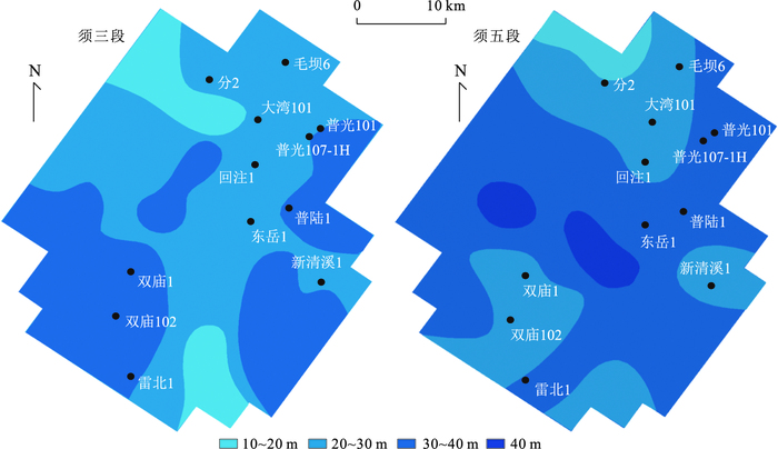
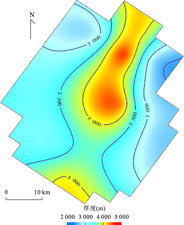
The source rock characteristics, which can be evaluated quantitatively by the geophysical prediction, are the basis of the hydrocarbon-generation evolution study. However, it is difficult to carry out a quantitative evaluation of the total organic carbon (TOC) content and thickness for the source rock in Puguang area due to lack of available drillings. The TOC content and thickness of Xujiahe Formation source rock in Puguang area were geophysically predicted by the quantitative prediction technology of the TOC volume in this study. The results show that Xujiahe Formation is mainly a fair source rock with the TOC values ranging from 0.6% to 1.5%, and the distribution of the TOC content is mainly in the banded structure. The general thickness of the effective source rock ranges from 20 to 30 m in Xusan Member, and 30 to 40 m in Xuwu Member, respectively. The erosion thickness is about 2 000 to 5 000 m with a decreasing trend from the high part of the structure to both sides of the study area at Late Yanshanian. At the end of Jurassic, Xusan Member source rock reached the mature stage in most areas; but for Xuwu Member, only the source rock in the northern sag reached the mature stage and the hydrocarbon threshold. At present, Xusan and Xuwu Member source rocks are basically in the high maturity-over mature stage generating gas mainly, and the maturity decreases from north to south.
The source rock characteristics, which can be evaluated quantitatively by the geophysical prediction, are the basis of the hydrocarbon-generation evolution study. However, it is difficult to carry out a quantitative evaluation of the total organic carbon (TOC) content and thickness for the source rock in Puguang area due to lack of available drillings. The TOC content and thickness of Xujiahe Formation source rock in Puguang area were geophysically predicted by the quantitative prediction technology of the TOC volume in this study. The results show that Xujiahe Formation is mainly a fair source rock with the TOC values ranging from 0.6% to 1.5%, and the distribution of the TOC content is mainly in the banded structure. The general thickness of the effective source rock ranges from 20 to 30 m in Xusan Member, and 30 to 40 m in Xuwu Member, respectively. The erosion thickness is about 2 000 to 5 000 m with a decreasing trend from the high part of the structure to both sides of the study area at Late Yanshanian. At the end of Jurassic, Xusan Member source rock reached the mature stage in most areas; but for Xuwu Member, only the source rock in the northern sag reached the mature stage and the hydrocarbon threshold. At present, Xusan and Xuwu Member source rocks are basically in the high maturity-over mature stage generating gas mainly, and the maturity decreases from north to south.


2016, 41(5): 853-863.
doi: 10.3799/dqkx.2016.072
Abstract:
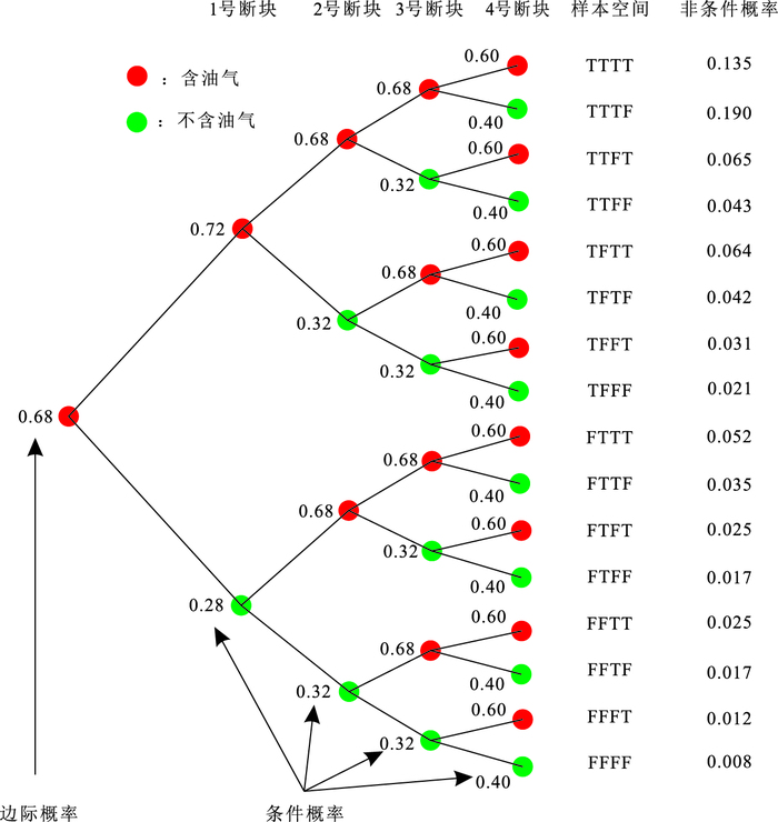
Resources of the zone or the 3rd (or the 4th) tectonic trap are often evaluated by directly and simply cumulating the resources size of its segments weighted by discovery probability in China. Obviously, not all segments certainly have been discovered due to constraints of special geological conditions. In addition, prediction value generally doesn't honestly reflect the practical geological model if quantifying the direct effect of geological model constraints on volumetric parameters and Monte Carlo simulation process is ignored. For the development of PetroV, an improved non-deterministic volumetric method with quantifying kinds of geological constraints is devised in the paper: to sample and composite the undivided segments which should stay in the same combination, then quantify impact caused by the key geological factors in order to objectively delineate volumetric uncertainty. It is confirmed by applications and detailed analysis that "combination probability cumulating" method proposed in this paper could explain each quantile value of resource distribution with clear geological scenarios, which leads to more reasonable exploration strategies.
Resources of the zone or the 3rd (or the 4th) tectonic trap are often evaluated by directly and simply cumulating the resources size of its segments weighted by discovery probability in China. Obviously, not all segments certainly have been discovered due to constraints of special geological conditions. In addition, prediction value generally doesn't honestly reflect the practical geological model if quantifying the direct effect of geological model constraints on volumetric parameters and Monte Carlo simulation process is ignored. For the development of PetroV, an improved non-deterministic volumetric method with quantifying kinds of geological constraints is devised in the paper: to sample and composite the undivided segments which should stay in the same combination, then quantify impact caused by the key geological factors in order to objectively delineate volumetric uncertainty. It is confirmed by applications and detailed analysis that "combination probability cumulating" method proposed in this paper could explain each quantile value of resource distribution with clear geological scenarios, which leads to more reasonable exploration strategies.


2016, 41(5): 864-872.
doi: 10.3799/dqkx.2016.073
Abstract:
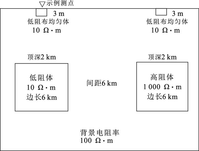
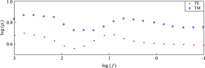
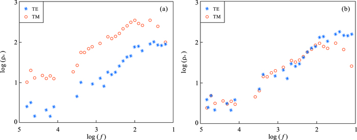
The static shift of MT exploration is the issue concerned by domestic and foreign experts, and many correction methods were proposed. But each method has its advantages and disadvantages. In this paper, the static shift of MT and its derivative methods is discussed from the basic theory, and a joint correction method is proposed using the improved plane Hanning window weighting and the first branch coincidence methods. The optimal estimation and iterative methods are used to combine the correction methods for static shift problems with different formations, and the correction method is consummated for realizing large-scale data processing. The correctness of the correction method is verified using the synthetic sounding. And the effectiveness is verified by the comparison of the application results with real data and priori information.
The static shift of MT exploration is the issue concerned by domestic and foreign experts, and many correction methods were proposed. But each method has its advantages and disadvantages. In this paper, the static shift of MT and its derivative methods is discussed from the basic theory, and a joint correction method is proposed using the improved plane Hanning window weighting and the first branch coincidence methods. The optimal estimation and iterative methods are used to combine the correction methods for static shift problems with different formations, and the correction method is consummated for realizing large-scale data processing. The correctness of the correction method is verified using the synthetic sounding. And the effectiveness is verified by the comparison of the application results with real data and priori information.


2016, 41(5): 873-885.
doi: 10.3799/dqkx.2016.074
Abstract:
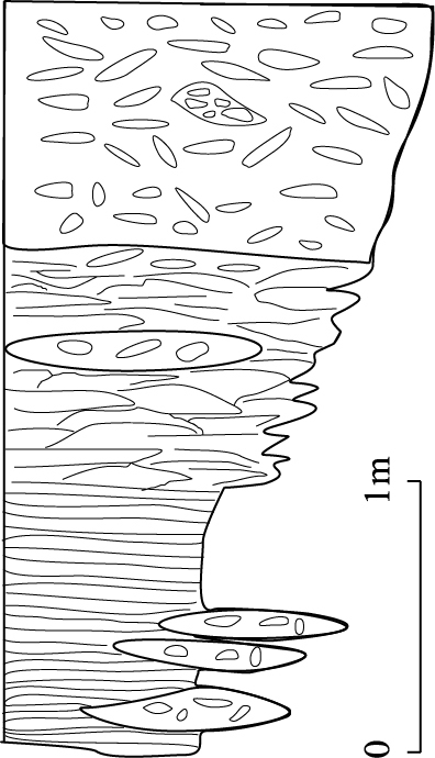
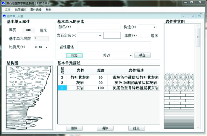
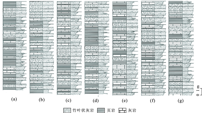
Lithostratigraphic digitalization and visualization is the foundation of digital stratigraphic research. It is also the first step to extricate stratigraphy from traditional discrete description and explore the new concise scientific methods. Regarding the basic lithostratigraphic units as "lithostratigraphic cells", this paper explores a geological process in which a simple sedimentary sequence, through erosion, transformation, burial and diagenesis, eventually forms a variety of complex stratified rock series. A new theory, procedure and technical method for defining the lithostratigraphic units of the Liangjiashan Formation is presented in this study. The one-dimension digital description of Liangjiashan Formation is fulfilled by an independently developed software platform, RSD. The survey confirms that the conclusion drawn from virtual computation is consistent with that of the field geological investigation. The digital description of the Liangjiashan Formation reveals that its lithostratigraphic records in different regions have originated from the same basic lithostratigraphic units even though their appearances differ significantly from each other. The results provide a theoretical basis and technical feasibility for the quantitative description of such details as the motion amplitude and rate of ancient basin system, which can not only save both outdoor and indoor repeated workload, but also can help dig deeper into the information stored in the rock strata.
Lithostratigraphic digitalization and visualization is the foundation of digital stratigraphic research. It is also the first step to extricate stratigraphy from traditional discrete description and explore the new concise scientific methods. Regarding the basic lithostratigraphic units as "lithostratigraphic cells", this paper explores a geological process in which a simple sedimentary sequence, through erosion, transformation, burial and diagenesis, eventually forms a variety of complex stratified rock series. A new theory, procedure and technical method for defining the lithostratigraphic units of the Liangjiashan Formation is presented in this study. The one-dimension digital description of Liangjiashan Formation is fulfilled by an independently developed software platform, RSD. The survey confirms that the conclusion drawn from virtual computation is consistent with that of the field geological investigation. The digital description of the Liangjiashan Formation reveals that its lithostratigraphic records in different regions have originated from the same basic lithostratigraphic units even though their appearances differ significantly from each other. The results provide a theoretical basis and technical feasibility for the quantitative description of such details as the motion amplitude and rate of ancient basin system, which can not only save both outdoor and indoor repeated workload, but also can help dig deeper into the information stored in the rock strata.


2016, 41(5): 886-894.
doi: 10.3799/dqkx.2016.075
Abstract:
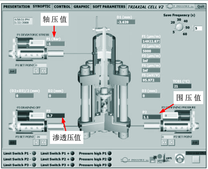
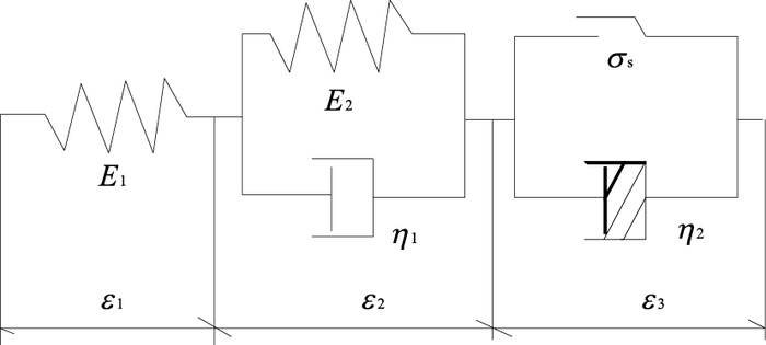
Rheological experiments and the constitutive research on mudstone under hydro-mechanical coupling plays an important role in long-term stability analysis of geotechnical engineering. The rock's temperature, stress, seepage coupling triaxial rheological experiment device was used on mudstone under the hydro-mechanical coupling state and dry state respectively, and their ruptured sections were scanned by electron microscopy after rheological experiments. The results show the follows: (1) The number of mutations in the map of mudstone strain-time under hydro-mechanical coupling is significantly more than that under dry state, which means the osmotic pressure has strong damage effect on mudstone. (2) The axial strain, hoop strain and volume strain of mudstone under the hydro-mechanical coupling state are greater than those under dry state because of the action of osmotic pressure. The stress of mudstone under the hydro-mechanical coupling state when rheological damage occurs is 66.7% of that of dry state, and osmotic pressure has obvious weakening effect on rock strength. (3) The rock's strength reduces faster under the effect of hydro-mechanical coupling by comparison with mesoscopic fracture characteristics of mudstone. (4) The mudstone's rheological model is predicted by results of the test, the modified K-B model was adopted to describe the mudstone rheological deformation behavior, and the fitting results show that the modified K-B model can well simulate the whole process of the mudstone rheological deformation behavior under the two states, and the constitutive model parameter values of the rheological deformation were obtained, which lay solid foundation for long-term rock mass deformation research under the hydro-mechanical coupling.
Rheological experiments and the constitutive research on mudstone under hydro-mechanical coupling plays an important role in long-term stability analysis of geotechnical engineering. The rock's temperature, stress, seepage coupling triaxial rheological experiment device was used on mudstone under the hydro-mechanical coupling state and dry state respectively, and their ruptured sections were scanned by electron microscopy after rheological experiments. The results show the follows: (1) The number of mutations in the map of mudstone strain-time under hydro-mechanical coupling is significantly more than that under dry state, which means the osmotic pressure has strong damage effect on mudstone. (2) The axial strain, hoop strain and volume strain of mudstone under the hydro-mechanical coupling state are greater than those under dry state because of the action of osmotic pressure. The stress of mudstone under the hydro-mechanical coupling state when rheological damage occurs is 66.7% of that of dry state, and osmotic pressure has obvious weakening effect on rock strength. (3) The rock's strength reduces faster under the effect of hydro-mechanical coupling by comparison with mesoscopic fracture characteristics of mudstone. (4) The mudstone's rheological model is predicted by results of the test, the modified K-B model was adopted to describe the mudstone rheological deformation behavior, and the fitting results show that the modified K-B model can well simulate the whole process of the mudstone rheological deformation behavior under the two states, and the constitutive model parameter values of the rheological deformation were obtained, which lay solid foundation for long-term rock mass deformation research under the hydro-mechanical coupling.


2016, 41(5): 895-900.
doi: 10.3799/dqkx.2016.076
Abstract:
Weakening matrix theory was applied on design of the drilling bit in order to improve the drilling efficiency of impregnated diamond bit in hard compact rock formation in this study. The matrix was analyzed with SEM and EDS. The results show that it can help improve drilling rate by putting matrix weakening particle into matrix. Under the process of drilling, the weakening particle can drop easily from matrix developing non-smooth surface; the pressure between surface and rock is increased and the weakening particle participates in wearing matrix, increasing abrasive power of rock powder, promoting speed of diamond metabolism. There is an optimum range for matrix weaken ratio, designing too high or too low simply can not improve drilling rate and bit life.
Weakening matrix theory was applied on design of the drilling bit in order to improve the drilling efficiency of impregnated diamond bit in hard compact rock formation in this study. The matrix was analyzed with SEM and EDS. The results show that it can help improve drilling rate by putting matrix weakening particle into matrix. Under the process of drilling, the weakening particle can drop easily from matrix developing non-smooth surface; the pressure between surface and rock is increased and the weakening particle participates in wearing matrix, increasing abrasive power of rock powder, promoting speed of diamond metabolism. There is an optimum range for matrix weaken ratio, designing too high or too low simply can not improve drilling rate and bit life.


