2016 Vol. 41, No. 7
Display Method:
 PDF 248KB
2016, 41(7): 1081-1098.
doi: 10.3799/dqkx.2016.090
Abstract:
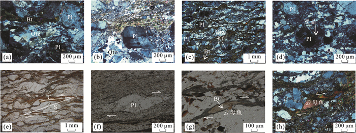
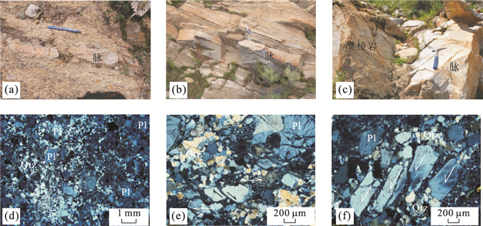
The systematic kinematic and dynamic researches of Jigong-Sefu ductile shear zone not only have theoretical significance for the orogenic tectonics, but also advance geological studies of the middle-southern segments of the Tibetan plateau. Quxu ductile shear zone, a vital part of geological structures of Quxu batholith in Gangdese magmatic belt, has experienced large-scale structural deformations featuring with ductile strike-slip shearing, predominantly of dextral shearing since Cenozoic (top to the east). Based on outcrop observations of structural schist, protomylonite, mylonite and felsic veins and thin section analyses as well as quartz EBSD fabric testing, one stage of ductile deformation was identified in the Quxu shear zone. It is found by mineral deformation geothermometer of quartz-feldspar and quartz EBSD fabric analyses that the shear zone is characterized by middle temperature deformations with 500-550 ℃ (from high greenschist facies to amphibolite facies). Structural deformation of the Quxu shear zone observed in South Tibet reveals that the asymmetric folds, structural lenses, σ porphyroclast, S-C fabrics and boudinages are good indicators, which suggest a dextral strike-slip shearing. Average values of 34 mylonitic foliations and 9 stretching lineation are 355°∠70° and 95°∠8°. Moreover, two kinds of granitic veins were identified in the Quxu shear zone. Combined with field occurrence, microstructures, zircon CL features and geochemistry of the felsic veins, we interpret that the two kinds of granitic veins are syn-tectonic shearing intrusions, whose ages can make an accurate geochronological constraint on the formation of the Quxu shear zone. LA-ICP-MS zircon dating of the granitic veins yields ages of 38.67±0.88 Ma and 35.05±0.29 Ma, respectively, further indicating that the Quxu shear zone started at 35-38 Ma (Priabonian stage of Eocene). The shearing time is consistent with that of the late stage of the Indian-Asian plate collision. Therefore, it is concluded that the Quxu shear zone might be related to continuous northward subduction of the Indian plate, corresponding to tectonic stress relation and an intra-continental deformation event.
The systematic kinematic and dynamic researches of Jigong-Sefu ductile shear zone not only have theoretical significance for the orogenic tectonics, but also advance geological studies of the middle-southern segments of the Tibetan plateau. Quxu ductile shear zone, a vital part of geological structures of Quxu batholith in Gangdese magmatic belt, has experienced large-scale structural deformations featuring with ductile strike-slip shearing, predominantly of dextral shearing since Cenozoic (top to the east). Based on outcrop observations of structural schist, protomylonite, mylonite and felsic veins and thin section analyses as well as quartz EBSD fabric testing, one stage of ductile deformation was identified in the Quxu shear zone. It is found by mineral deformation geothermometer of quartz-feldspar and quartz EBSD fabric analyses that the shear zone is characterized by middle temperature deformations with 500-550 ℃ (from high greenschist facies to amphibolite facies). Structural deformation of the Quxu shear zone observed in South Tibet reveals that the asymmetric folds, structural lenses, σ porphyroclast, S-C fabrics and boudinages are good indicators, which suggest a dextral strike-slip shearing. Average values of 34 mylonitic foliations and 9 stretching lineation are 355°∠70° and 95°∠8°. Moreover, two kinds of granitic veins were identified in the Quxu shear zone. Combined with field occurrence, microstructures, zircon CL features and geochemistry of the felsic veins, we interpret that the two kinds of granitic veins are syn-tectonic shearing intrusions, whose ages can make an accurate geochronological constraint on the formation of the Quxu shear zone. LA-ICP-MS zircon dating of the granitic veins yields ages of 38.67±0.88 Ma and 35.05±0.29 Ma, respectively, further indicating that the Quxu shear zone started at 35-38 Ma (Priabonian stage of Eocene). The shearing time is consistent with that of the late stage of the Indian-Asian plate collision. Therefore, it is concluded that the Quxu shear zone might be related to continuous northward subduction of the Indian plate, corresponding to tectonic stress relation and an intra-continental deformation event.


2016, 41(7): 1099-1109.
doi: 10.3799/dqkx.2016.091
Abstract:
In the Sailiyakedaban area (in West Kunlun Mountains), Yecheng, South Xinjiang, a series of coal-bearing clastic strata, distributed in the Mazha-Kangxiwa tectonic belt, is named as the Sailiyakedaban Group and considered as the Early-Middle Triassic strata. The Mazha-Kangxiwa tectonic belt is considered as the boundaries between the West Kunlun and the Karakoram plates, as well as between the Eurasian plate and the Paleo-Tethys domain, so the dating of the coal-bearing clastics in the Mazha-Kangxiwa tectonic belt is significant to the study on the tectonic and paleogeographic evolution in West Kunlun Mountains. Lithologically, the coal-bearing clastic strata can be divided into three parts: the lower part consists mainly of conglomerates, the middle part is characterized by coals, and the upper part consists mainly of pebbly sandstones. Abundant plant fossils, of 17 genus and 20 species, were collected from the middle part of the strata. The flora is predominated by Cycadophytes (25%), ferns (20%), Ginkgopsida (20%), and Confiers (15%). Similar to the Yarkant Group flora found in the West Kunlun Mountains and the margin of the Tarim basin, it shows the characteristics of both Coniopteris-Phoenicopsis flora in North China and Ptilophyllum-Conioptersis flora in South China during the Early-Middle Jurassic transition. In addition, the coal-bearing clastic deposit in the Mazha-Kangxiwa tectonic belt not only is correlated with the Yarkant Group in the stratigraphic sequences and lithostratigraphy, but also conforms to the definition of the Yarkant Group. Therefore, the stratigraphic unit "Sailiyakedaban Group" of the Early-Middle Triassic is proposed to be suspended for use and to be replaced by the Yarkant Group of the Early-Middle Jurassic.
In the Sailiyakedaban area (in West Kunlun Mountains), Yecheng, South Xinjiang, a series of coal-bearing clastic strata, distributed in the Mazha-Kangxiwa tectonic belt, is named as the Sailiyakedaban Group and considered as the Early-Middle Triassic strata. The Mazha-Kangxiwa tectonic belt is considered as the boundaries between the West Kunlun and the Karakoram plates, as well as between the Eurasian plate and the Paleo-Tethys domain, so the dating of the coal-bearing clastics in the Mazha-Kangxiwa tectonic belt is significant to the study on the tectonic and paleogeographic evolution in West Kunlun Mountains. Lithologically, the coal-bearing clastic strata can be divided into three parts: the lower part consists mainly of conglomerates, the middle part is characterized by coals, and the upper part consists mainly of pebbly sandstones. Abundant plant fossils, of 17 genus and 20 species, were collected from the middle part of the strata. The flora is predominated by Cycadophytes (25%), ferns (20%), Ginkgopsida (20%), and Confiers (15%). Similar to the Yarkant Group flora found in the West Kunlun Mountains and the margin of the Tarim basin, it shows the characteristics of both Coniopteris-Phoenicopsis flora in North China and Ptilophyllum-Conioptersis flora in South China during the Early-Middle Jurassic transition. In addition, the coal-bearing clastic deposit in the Mazha-Kangxiwa tectonic belt not only is correlated with the Yarkant Group in the stratigraphic sequences and lithostratigraphy, but also conforms to the definition of the Yarkant Group. Therefore, the stratigraphic unit "Sailiyakedaban Group" of the Early-Middle Triassic is proposed to be suspended for use and to be replaced by the Yarkant Group of the Early-Middle Jurassic.


2016, 41(7): 1110-1120.
doi: 10.3799/dqkx.2016.092
Abstract:
Provenance of manganese deposit is a key problem in the manganese metallogenic study. For a better understanding on the metallogenic process of the Nanhuan manganese deposit in Songtao area, East Guizhou Province, we need to gain a clear idea of the provenance of this manganese deposit. The Sr isotope study on the Mn deposit in Lower Nanhuan Datangpo Formation in Songtao, East Guizhou Province indicates that 87Sr/86Sr ratios in 15 samples vary in 0.705 727-0.732 536. Studied samples include Mn ore, Mn shale and black shale in the Mn-bearing layer and the highest 87Sr/86Sr ratio appears in the black shale sample. With Al (%) increasing in samples, 87Sr/86Sr ratios show two changing trends: the rising trend indicates terrigenous materials input and the falling trend indicates the deep hydrothermal sources input. As to 87Sr/86Sr ratios via Mn (%), there is no significant correlation coefficient, but 87Sr/86Sr ratios decrease when Mn (%) increase generally, according to residual analysis, we find that this is caused by the convergence fluctuation of 87Sr/86Sr ratios against the Mn(%) changes. The broad variation of 87Sr/86Sr ratios in Mn layer is caused by the dual inputs from terrigenous materials and hydrothermal sources. Compared with the contemporary (about 660 Ma)Sr isotope ratio in paleoseawater and the Sr isotope data from different ages Mn deposit world wide, we find that the broad variation of 87Sr/86Sr ratios in the Datangpo Formation. Mn layer does not conform to the feature of hydrogenetic Mn deposit. Considered with the specific geological background, we believe that the accumulation and precipitation of manganese are separated processes:the accumulation of Mn had finished in the anoxic basin during the Sturtian glaciation, whereas the Mn deposit precipitated in an unstable paleoceanographic environment at the beginning of interglaciation.
Provenance of manganese deposit is a key problem in the manganese metallogenic study. For a better understanding on the metallogenic process of the Nanhuan manganese deposit in Songtao area, East Guizhou Province, we need to gain a clear idea of the provenance of this manganese deposit. The Sr isotope study on the Mn deposit in Lower Nanhuan Datangpo Formation in Songtao, East Guizhou Province indicates that 87Sr/86Sr ratios in 15 samples vary in 0.705 727-0.732 536. Studied samples include Mn ore, Mn shale and black shale in the Mn-bearing layer and the highest 87Sr/86Sr ratio appears in the black shale sample. With Al (%) increasing in samples, 87Sr/86Sr ratios show two changing trends: the rising trend indicates terrigenous materials input and the falling trend indicates the deep hydrothermal sources input. As to 87Sr/86Sr ratios via Mn (%), there is no significant correlation coefficient, but 87Sr/86Sr ratios decrease when Mn (%) increase generally, according to residual analysis, we find that this is caused by the convergence fluctuation of 87Sr/86Sr ratios against the Mn(%) changes. The broad variation of 87Sr/86Sr ratios in Mn layer is caused by the dual inputs from terrigenous materials and hydrothermal sources. Compared with the contemporary (about 660 Ma)Sr isotope ratio in paleoseawater and the Sr isotope data from different ages Mn deposit world wide, we find that the broad variation of 87Sr/86Sr ratios in the Datangpo Formation. Mn layer does not conform to the feature of hydrogenetic Mn deposit. Considered with the specific geological background, we believe that the accumulation and precipitation of manganese are separated processes:the accumulation of Mn had finished in the anoxic basin during the Sturtian glaciation, whereas the Mn deposit precipitated in an unstable paleoceanographic environment at the beginning of interglaciation.


2016, 41(7): 1121-1140.
doi: 10.3799/dqkx.2016.093
Abstract:
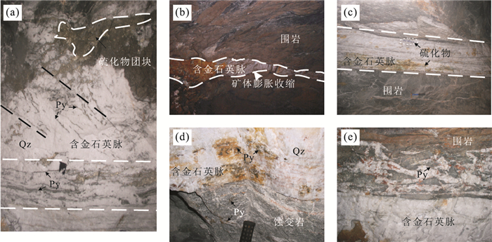
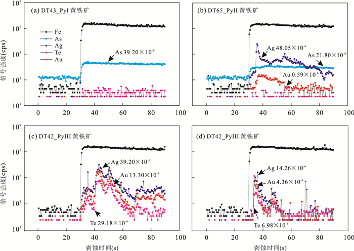
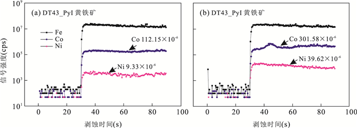
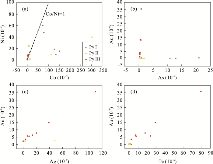
Situated in the southern margin of the North China craton, the Xiaoqinling district is one of the most important gold metallogenic belts and has been the second largest gold producer in China. Although most gold deposits have been extensively studied, issues related to the source of the ore materials and fluids remain debated. This paper presents a study of the distribution characteristics of trace elements in gold-bearing pyrite to explore the source of ore-forming materials, the precipitation mechanism and ore genesis. The Dongtongyu lode gold deposit is the important deposit in Xiaoqinling and pyrite is the predominant sulfide mineral. Three generations of pyrite were identified, broadly corresponding to the three mineralization stages, and termed as the first generation, second generation and third generation (PyⅠ, PyⅡ and PyⅢ). The first generation (PyⅠ) is mainly present as isolations or as aggregate masses dispersed in milky quartz veins, consisting of coarse-grained, euhedral to subhedral crystals. The second generation (PyⅡ) pyrite occurs as veins or veinlets generally associated with light gray quartz or cutting milky quartz. Many grains are porous and contain abundant micro-fractures that are usually filled with later-stage quartz, other sulfide minerals and free gold. The third generation (PyⅢ) pyrite is commonly intergrown with other sulfide minerals including chalcopyrite, sphalerite, and galena. Laser ablation inductively coupled plasma mass spectrometry (LA-ICP-MS) results show that the average content of As in PyⅠ is 16.63×10⁻⁶, and the contents of Au, Ag and Te are low and often below detection limit. In contrast to PyⅠ, the content of As in PyⅡ is relatively lower, and that of Au, Ag and Te are slightly higher. Particularly, the stage PyⅢ exhibits distinguished compositions and significantly enriched in Au (up to 35.58×10⁻⁶), Ag and Te (up to 79.79 ×10⁻⁶), but with most of the content of As blow the detection limits. Moreover, The Co/Ni ratios of pyrite in different generations are basically > 1, and the contents of Co, Ni and Co/Ni in PyⅢ are much lower than those in PyⅡ and PyⅠ. The results show that As is always below or only marginally higher than the detection limits, and plays an insignificant role in gold mineralization. There is prominently positive correlation relationship between Au, Ag, and Te in the third generation of pyrite (PyⅢ), indicating that tellurium is closely related with gold and silver. Moreover, significant Au, Ag and Te are enriched in the PyⅢ, highlighting the role of Te as important scavengers in transfer, transport, enrichment and precipitation of gold and silver. An intimate Te-Au-Ag association has been widely noticed in widespread gold mineralization in Xiaoqinling gold district, and low-As, high-Te in pyrite, suggesting that the ore-forming materials and ore-forming fluids of the gold deposits may have come from the deep magma devolatilization or mantle degassing, rather than being involved with the regional metamorphism.
Situated in the southern margin of the North China craton, the Xiaoqinling district is one of the most important gold metallogenic belts and has been the second largest gold producer in China. Although most gold deposits have been extensively studied, issues related to the source of the ore materials and fluids remain debated. This paper presents a study of the distribution characteristics of trace elements in gold-bearing pyrite to explore the source of ore-forming materials, the precipitation mechanism and ore genesis. The Dongtongyu lode gold deposit is the important deposit in Xiaoqinling and pyrite is the predominant sulfide mineral. Three generations of pyrite were identified, broadly corresponding to the three mineralization stages, and termed as the first generation, second generation and third generation (PyⅠ, PyⅡ and PyⅢ). The first generation (PyⅠ) is mainly present as isolations or as aggregate masses dispersed in milky quartz veins, consisting of coarse-grained, euhedral to subhedral crystals. The second generation (PyⅡ) pyrite occurs as veins or veinlets generally associated with light gray quartz or cutting milky quartz. Many grains are porous and contain abundant micro-fractures that are usually filled with later-stage quartz, other sulfide minerals and free gold. The third generation (PyⅢ) pyrite is commonly intergrown with other sulfide minerals including chalcopyrite, sphalerite, and galena. Laser ablation inductively coupled plasma mass spectrometry (LA-ICP-MS) results show that the average content of As in PyⅠ is 16.63×10⁻⁶, and the contents of Au, Ag and Te are low and often below detection limit. In contrast to PyⅠ, the content of As in PyⅡ is relatively lower, and that of Au, Ag and Te are slightly higher. Particularly, the stage PyⅢ exhibits distinguished compositions and significantly enriched in Au (up to 35.58×10⁻⁶), Ag and Te (up to 79.79 ×10⁻⁶), but with most of the content of As blow the detection limits. Moreover, The Co/Ni ratios of pyrite in different generations are basically > 1, and the contents of Co, Ni and Co/Ni in PyⅢ are much lower than those in PyⅡ and PyⅠ. The results show that As is always below or only marginally higher than the detection limits, and plays an insignificant role in gold mineralization. There is prominently positive correlation relationship between Au, Ag, and Te in the third generation of pyrite (PyⅢ), indicating that tellurium is closely related with gold and silver. Moreover, significant Au, Ag and Te are enriched in the PyⅢ, highlighting the role of Te as important scavengers in transfer, transport, enrichment and precipitation of gold and silver. An intimate Te-Au-Ag association has been widely noticed in widespread gold mineralization in Xiaoqinling gold district, and low-As, high-Te in pyrite, suggesting that the ore-forming materials and ore-forming fluids of the gold deposits may have come from the deep magma devolatilization or mantle degassing, rather than being involved with the regional metamorphism.


2016, 41(7): 1141-1155.
doi: 10.3799/dqkx.2016.094
Abstract:
The Mesozoic Mongol-Okhotsk orogeny in Northeast Asia is a significant tectonic event which has attracted interest of many geologists. A tectonic unit involved in strong contractional deformation has been identified under the Early Cretaceous rifting sequences in the Beier depression of the Hailar basin, based on the newly obtained petroleum exploration data including seismic reflection, drilling and well logging. Structural analyses show that the structural system is composed of one major ENE trending overthrust fault and associated thrusting-folding deformations. Lithological and stratigraphic characteristics and dating results of detrital zircon U-Pb show that the strata consist of Late Jurassic terrigenous clastic rock, as a part of the Upper Jurassic Tamulangou Formation in this region. Considering the time of the development of overlying faulted basins and the emplacement of coeval metamorphic core complexes in surrounding area, it is suggested that the thrusting-folding event of the Hailar basin mainly occurred during early stage of the Early Cretaceous (145-133 Ma), which is a key structural record resulted from the Mongol-Okhotsk collisional orogeny during the Late Mesozoic.
The Mesozoic Mongol-Okhotsk orogeny in Northeast Asia is a significant tectonic event which has attracted interest of many geologists. A tectonic unit involved in strong contractional deformation has been identified under the Early Cretaceous rifting sequences in the Beier depression of the Hailar basin, based on the newly obtained petroleum exploration data including seismic reflection, drilling and well logging. Structural analyses show that the structural system is composed of one major ENE trending overthrust fault and associated thrusting-folding deformations. Lithological and stratigraphic characteristics and dating results of detrital zircon U-Pb show that the strata consist of Late Jurassic terrigenous clastic rock, as a part of the Upper Jurassic Tamulangou Formation in this region. Considering the time of the development of overlying faulted basins and the emplacement of coeval metamorphic core complexes in surrounding area, it is suggested that the thrusting-folding event of the Hailar basin mainly occurred during early stage of the Early Cretaceous (145-133 Ma), which is a key structural record resulted from the Mongol-Okhotsk collisional orogeny during the Late Mesozoic.


2016, 41(7): 1156-1170.
doi: 10.3799/dqkx.2016.515
Abstract:
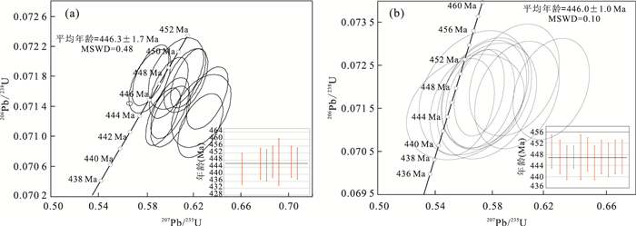
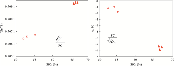
The Qilian orogenic belt is divided into the North, Central and South Qilian belts. The Saizhisi granodiorite is located between Central and South Qilian. In order to study the petrogensis and dynamic background of Saizhisi rocks, zircon U-Pb chronology, Hf isotope, whole rock geochemistry and Sr-Nd isotopes are reported for granodiorite and mafic microgranular enclaves (MMEs) in this area. The LA-ICP-MS analyses on zircons from both the Saizhisi granodiorite and MMEs yielded similar ages at 446.1±1.3 Ma and 446.0±1.0 Ma, respectively. The MMEs contain needle-like apatite, and they are characterized by lower SiO2 contents and higher Na2O/K2O ratios. Their REEs are similar to those of Saizhisi granodiorite and ∑REE are lower than those of the host granodiorite; The 86Sr/87Sr of MMEs=0.706 4-0.706 7, the εNd(t) of MMEs=-7.38 to -7.97. The elemental, U-Pb dating and Sr-Nd isotope suggest that they might have been formed by mixing of mafice and felsic member magmas. The Saizhisi granodiorite is metaluminous to weakly peraluminous with SiO2=66.45%-68.12%, Na2O/K2O=0.80-0.97, and A/CNK=0.91-1.03. The granodiorite is enriched in LILEs and depleted in HFSE, enriched in LREE contents and depleted in HREE contents with negative Euanomaly. The 86Sr/87Sr(0.709 3-0.709 5) and εNd(t) (-7.3794--7.9674) of Saizhisi granodiorite is similar to those of I-type granite of the Qilian Orogen belt. The εHf(t) of Saizhisi granodiorite=1.7-6.8, TDM2=995-1 750 Ma. It is concluded that the Saizhisi granodiorite might have been formed by mixing of mafice and felsic member magmas. Combined with the regional tectonic evolution, it is suggested that the Saizhisi granodiorite was formed in a subduction environment and mostly generated by the mantle which was formed by the lower crust intruded by the upwelling mantle.
The Qilian orogenic belt is divided into the North, Central and South Qilian belts. The Saizhisi granodiorite is located between Central and South Qilian. In order to study the petrogensis and dynamic background of Saizhisi rocks, zircon U-Pb chronology, Hf isotope, whole rock geochemistry and Sr-Nd isotopes are reported for granodiorite and mafic microgranular enclaves (MMEs) in this area. The LA-ICP-MS analyses on zircons from both the Saizhisi granodiorite and MMEs yielded similar ages at 446.1±1.3 Ma and 446.0±1.0 Ma, respectively. The MMEs contain needle-like apatite, and they are characterized by lower SiO2 contents and higher Na2O/K2O ratios. Their REEs are similar to those of Saizhisi granodiorite and ∑REE are lower than those of the host granodiorite; The 86Sr/87Sr of MMEs=0.706 4-0.706 7, the εNd(t) of MMEs=-7.38 to -7.97. The elemental, U-Pb dating and Sr-Nd isotope suggest that they might have been formed by mixing of mafice and felsic member magmas. The Saizhisi granodiorite is metaluminous to weakly peraluminous with SiO2=66.45%-68.12%, Na2O/K2O=0.80-0.97, and A/CNK=0.91-1.03. The granodiorite is enriched in LILEs and depleted in HFSE, enriched in LREE contents and depleted in HREE contents with negative Euanomaly. The 86Sr/87Sr(0.709 3-0.709 5) and εNd(t) (-7.3794--7.9674) of Saizhisi granodiorite is similar to those of I-type granite of the Qilian Orogen belt. The εHf(t) of Saizhisi granodiorite=1.7-6.8, TDM2=995-1 750 Ma. It is concluded that the Saizhisi granodiorite might have been formed by mixing of mafice and felsic member magmas. Combined with the regional tectonic evolution, it is suggested that the Saizhisi granodiorite was formed in a subduction environment and mostly generated by the mantle which was formed by the lower crust intruded by the upwelling mantle.


2016, 41(7): 1171-1187.
doi: 10.3799/dqkx.2016.095
Abstract:
The comprehensive analysis of provenance-sedimentary system and provenance tectonic setting is the basis of oil and gas exploration, the provenance-sedimentary system is the main influence factor of the original reservoir. The North Yellow Sea basin is a Mesozoic-Cenozoic transtensional faulted basin located between Sulu-Linjinjiang orogeny and Jiao-Liao uplift. The delta sand deposits developed during the Middle-Late Jurassic have been confirmed by seismic and drilling data in the southwest of eastern sag, the North Yellow Sea basin. Some sedimentary types, including distributary channel, crevasse splay, mouth bar and distal bar, can be recognized in the core rocks and well loggings, and the progradation of sediments in northwestern orientation is shown in the seismic reflection. The analysis of petrology and mineralogy of the sandstone samples indicate that they contain granitic and acid volcanic compositions. The element geochemistry characteristics of the mudstone samples show that their major composition is felsic, and the provenance is the craton or the recycling orogeny. The Dickinson diagram of the sands demonstrates their compositions coming from both the craton or the recycling orogeny and volcanic arc orogeny. We suggest that the southwestern provenance in the eastern sag of the North Yellow Sea basin is the recycling orogeny. The granitic composition comes from the weathered basement granitic rocks, and the volcaniclastics may come from the syn-eruption, or from weathered pre-existing volcanic rocks.
The comprehensive analysis of provenance-sedimentary system and provenance tectonic setting is the basis of oil and gas exploration, the provenance-sedimentary system is the main influence factor of the original reservoir. The North Yellow Sea basin is a Mesozoic-Cenozoic transtensional faulted basin located between Sulu-Linjinjiang orogeny and Jiao-Liao uplift. The delta sand deposits developed during the Middle-Late Jurassic have been confirmed by seismic and drilling data in the southwest of eastern sag, the North Yellow Sea basin. Some sedimentary types, including distributary channel, crevasse splay, mouth bar and distal bar, can be recognized in the core rocks and well loggings, and the progradation of sediments in northwestern orientation is shown in the seismic reflection. The analysis of petrology and mineralogy of the sandstone samples indicate that they contain granitic and acid volcanic compositions. The element geochemistry characteristics of the mudstone samples show that their major composition is felsic, and the provenance is the craton or the recycling orogeny. The Dickinson diagram of the sands demonstrates their compositions coming from both the craton or the recycling orogeny and volcanic arc orogeny. We suggest that the southwestern provenance in the eastern sag of the North Yellow Sea basin is the recycling orogeny. The granitic composition comes from the weathered basement granitic rocks, and the volcaniclastics may come from the syn-eruption, or from weathered pre-existing volcanic rocks.


2016, 41(7): 1188-1197.
doi: 10.3799/dqkx.2016.096
Abstract:
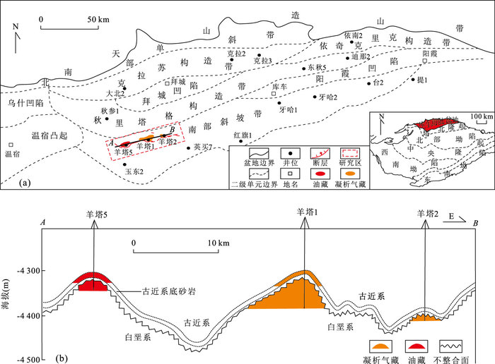
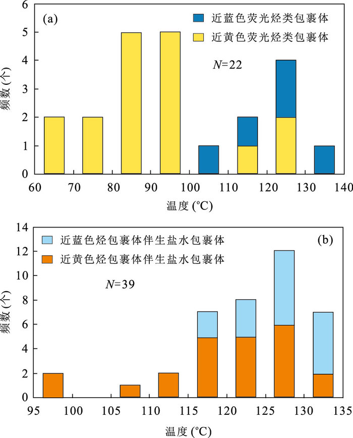
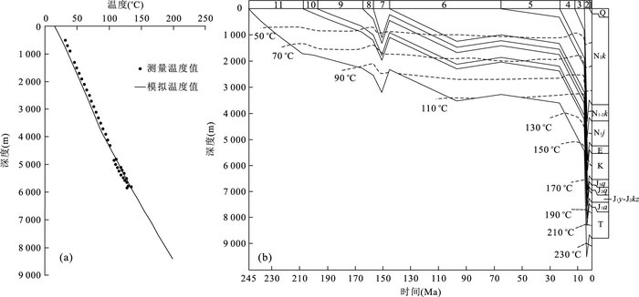
There are abundant oil and gas resources in the Yangtake area, Kuqa foreland basin, and it is significant for oil and gas exploration to study the hydrocarbon charge history and accumulation process in this area. Hydrocarbon accumulation process of the Yangtake area in the Kuqa foreland basin was investigated using an integrated fluid inclusion petrography, microthermometry, quantitative grain fluorescence analysis in combination with source rock thermal evolution and tectonic evolution in the Kuqa foreland basin in this study. The results indicate that hydrocarbon accumulated in the Yangtake area at the Late Neocene and experienced adjustment after the initial accumulation. The Middle Jurassic Qiakemake source rock in the Kuqa depression reached maturity (Ro > 0.5%) at about 15 Ma, and initially charged into the Yangtake area at Late Neogene Kuqa period (around 4.0 Ma). Low abundance oil inclusions with yellow fluorescence were formed at that time. Oil was mainly charged into the study area at around 3.5 Ma. The Middle to Lower Jurassic coaly source rock reached maturity at about 26 Ma, while large amount of natural gas was charged into the Yangtake tectonic belt until at about 3.5 Ma. Natural gas washed early charged oil, and formed near blue fluorescence oil inclusions with various gas-liquid ratios. During the mutual interacting between oil and gas, the oil-water contact was once at 5 390.75 m in the Yangta-1 area. With the strengthening of the Himalayan orogeny, the Yangta-1 condensate gas reservoir was adjusted and the gas-water contact was shifted to its current depth of 5 379.70 m in the late deposition of the Kuqa Member.
There are abundant oil and gas resources in the Yangtake area, Kuqa foreland basin, and it is significant for oil and gas exploration to study the hydrocarbon charge history and accumulation process in this area. Hydrocarbon accumulation process of the Yangtake area in the Kuqa foreland basin was investigated using an integrated fluid inclusion petrography, microthermometry, quantitative grain fluorescence analysis in combination with source rock thermal evolution and tectonic evolution in the Kuqa foreland basin in this study. The results indicate that hydrocarbon accumulated in the Yangtake area at the Late Neocene and experienced adjustment after the initial accumulation. The Middle Jurassic Qiakemake source rock in the Kuqa depression reached maturity (Ro > 0.5%) at about 15 Ma, and initially charged into the Yangtake area at Late Neogene Kuqa period (around 4.0 Ma). Low abundance oil inclusions with yellow fluorescence were formed at that time. Oil was mainly charged into the study area at around 3.5 Ma. The Middle to Lower Jurassic coaly source rock reached maturity at about 26 Ma, while large amount of natural gas was charged into the Yangtake tectonic belt until at about 3.5 Ma. Natural gas washed early charged oil, and formed near blue fluorescence oil inclusions with various gas-liquid ratios. During the mutual interacting between oil and gas, the oil-water contact was once at 5 390.75 m in the Yangta-1 area. With the strengthening of the Himalayan orogeny, the Yangta-1 condensate gas reservoir was adjusted and the gas-water contact was shifted to its current depth of 5 379.70 m in the late deposition of the Kuqa Member.


2016, 41(7): 1198-1205.
doi: 10.3799/dqkx.2016.097
Abstract:
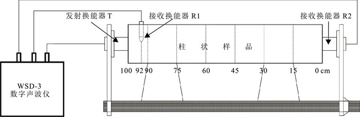
Porosity is one of the most important parameters for oil exploration and ocean topographic survey. The prediction of porosity in marine sediments has always been a difficulty. In this paper, the Gassmann equation was rearranged and utilized to estimate porosity based on the relationship between porosity and compressional wave velocity. The compressional wave velocity was measured on the deck based on the core samples collected in the southern South China Sea, and the porosity was measured in the laboratory. Porosity calculated using Gassmann equation was compared with that measured in laboratory. The results show that Gassmann equation can better predict the seafloor sediment porosity, and that is particularly accurate at shallow water areas. The sensitivity of Gassmann equation was studied by error norm method, and the results show that compressional wave velocity is the most influential parameter for porosity prediction.
Porosity is one of the most important parameters for oil exploration and ocean topographic survey. The prediction of porosity in marine sediments has always been a difficulty. In this paper, the Gassmann equation was rearranged and utilized to estimate porosity based on the relationship between porosity and compressional wave velocity. The compressional wave velocity was measured on the deck based on the core samples collected in the southern South China Sea, and the porosity was measured in the laboratory. Porosity calculated using Gassmann equation was compared with that measured in laboratory. The results show that Gassmann equation can better predict the seafloor sediment porosity, and that is particularly accurate at shallow water areas. The sensitivity of Gassmann equation was studied by error norm method, and the results show that compressional wave velocity is the most influential parameter for porosity prediction.


2016, 41(7): 1206-1215.
doi: 10.3799/dqkx.2016.098
Abstract:
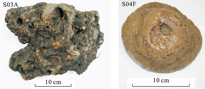
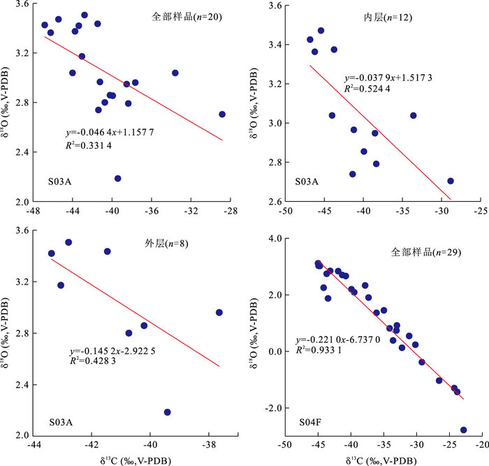
Cold seep carbonates record the changes of fluids and environments in the methane seepages, which is important to reveal the sedimentary environment changes. The carbon and oxygen isotope profiles of the northern South China Sea and their vary intervals were studied. The results show that there are correlations between δ13C and δ18O along the profiles. Combined with the published δ13C and δ18O data, it is suggested that the correlations between them along the profiles are common, with the maximum correlation coefficient R2 of 0.933 1. Accroding to the statistics results, both the δ13C and δ18O vary greatly for the cold seep carbonates in the northern South China Sea, which maximal varing interval can be 34.50×10⁻³ and 5.89%(Vienna Pee Dee Belemnite, V-PDB), respectively. The correlations between δ13C and δ18O along the profiles perhaps indicate the changes of original fluids, the mineral formation or recrystallization, the complex methane seep systems and the diagenetic effects. For different cold seep carbonates, the vary intervals of δ13C were influenced by the participation degree of seawater, and the vary intervals of δ18O perhaps were related with the precipitation temperature and the Mg of calcite.
Cold seep carbonates record the changes of fluids and environments in the methane seepages, which is important to reveal the sedimentary environment changes. The carbon and oxygen isotope profiles of the northern South China Sea and their vary intervals were studied. The results show that there are correlations between δ13C and δ18O along the profiles. Combined with the published δ13C and δ18O data, it is suggested that the correlations between them along the profiles are common, with the maximum correlation coefficient R2 of 0.933 1. Accroding to the statistics results, both the δ13C and δ18O vary greatly for the cold seep carbonates in the northern South China Sea, which maximal varing interval can be 34.50×10⁻³ and 5.89%(Vienna Pee Dee Belemnite, V-PDB), respectively. The correlations between δ13C and δ18O along the profiles perhaps indicate the changes of original fluids, the mineral formation or recrystallization, the complex methane seep systems and the diagenetic effects. For different cold seep carbonates, the vary intervals of δ13C were influenced by the participation degree of seawater, and the vary intervals of δ18O perhaps were related with the precipitation temperature and the Mg of calcite.


2016, 41(7): 1216-1224.
doi: 10.3799/dqkx.2016.099
Abstract:
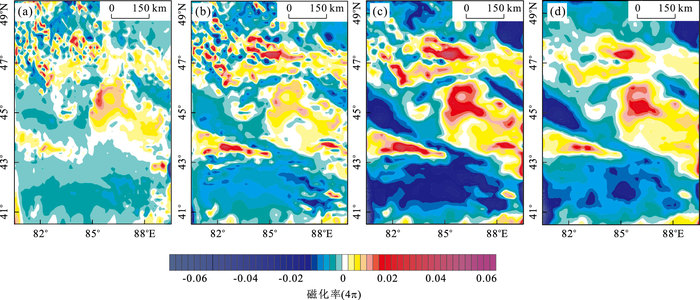
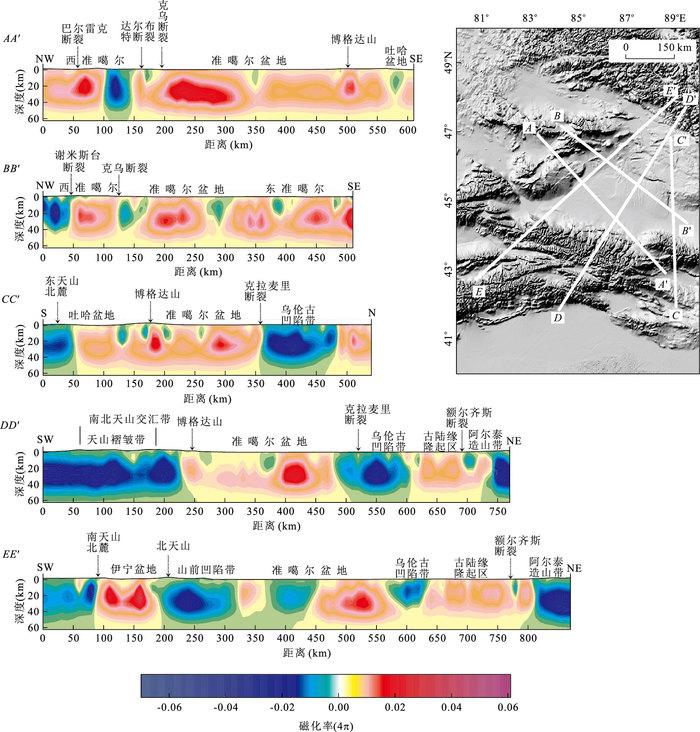
The Junggar block can be divided into east, west Junggar tectonic zones and Junggar basin. Since the Paleozoic, large scale volcanic activity and complex tectonic evolution occurred in the Junggar basin and its surroundings. There have long been controversies on the basement of the Junggar basin, its structure relationship with its surroundings and its evolution. In this paper, we use the EMAG2 lithospheric magnetic anomaly model, together with modern 3D inversion technique, to image the crustal magnetic susceptibility of the Junggar basin and its surroundings, and to obtain the magnetic structure of the 0-60 km depth range. The inversion results show that the magnetic structure of the crust in central Junggar basin is relatively complete, the west Junggar crust has a magnetic structure associated with subduction of oceanic crust arc environment, and both the east Junggar and the Turpan basin have thick and continuous magnetic layer with paleo-continental basement features. Moreover, the crustal magnetic susceptibility anomaly shows the regional fault structure and its deep extension features, and existence of concealed deep fault zone in the covered area as well. The quantitative explanation of the origin of the magnetic anomaly in this area provided in this paper can be useful information and reference for the further analysis of the relationship between the lithosphere structure and the surrounding tectonic units in Junggar area.
The Junggar block can be divided into east, west Junggar tectonic zones and Junggar basin. Since the Paleozoic, large scale volcanic activity and complex tectonic evolution occurred in the Junggar basin and its surroundings. There have long been controversies on the basement of the Junggar basin, its structure relationship with its surroundings and its evolution. In this paper, we use the EMAG2 lithospheric magnetic anomaly model, together with modern 3D inversion technique, to image the crustal magnetic susceptibility of the Junggar basin and its surroundings, and to obtain the magnetic structure of the 0-60 km depth range. The inversion results show that the magnetic structure of the crust in central Junggar basin is relatively complete, the west Junggar crust has a magnetic structure associated with subduction of oceanic crust arc environment, and both the east Junggar and the Turpan basin have thick and continuous magnetic layer with paleo-continental basement features. Moreover, the crustal magnetic susceptibility anomaly shows the regional fault structure and its deep extension features, and existence of concealed deep fault zone in the covered area as well. The quantitative explanation of the origin of the magnetic anomaly in this area provided in this paper can be useful information and reference for the further analysis of the relationship between the lithosphere structure and the surrounding tectonic units in Junggar area.


2016, 41(7): 1225-1230.
doi: 10.3799/dqkx.2016.100
Abstract:
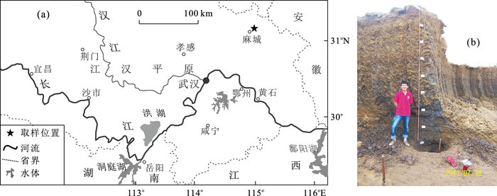
In order to reveal the sediment magnetism characteristics and its climatic environment evolution since Late Pleistocene of the Jianghan plain, we collected magnetic susceptibility samples from Macheng, the northeast margin of the Jianghan plain, for analysis. The results show that the mass susceptibility of magnetic materials in Macheng profile is relatively low(10.85×10⁻⁸ m3·kg-1 on average), and the variation range of mass susceptibility is narrow (5.76×10⁻⁸-23.39×10⁻⁸ m3·kg-1). However, the variation range of frequency susceptibility is relatively wide (5.35%-50.35% and 24.71% on average), which shows that the content of SP (super paramagnetism) particulate is high. The cyclic wave characteristics of magnetic susceptibility and frequency magnetic susceptibility data suggest that the paleoclimate environment of this region could be divided into 7 evolution phases. According to the chronological data, it is concluded that the sedimentary environment of this region has undergone limnetic facies sedimentary stage, lacustrine sedimentary stage, swamp sedimentary stage in flood plain since Late Pleistocene, whereas the climate has undergone the phased variation of humid-dry-cold-warm-wet-dry-cool-dry-cold-humid-dry (drought) and cool, which is consistent with the global climate change characteristics since Late Pleistocene.
In order to reveal the sediment magnetism characteristics and its climatic environment evolution since Late Pleistocene of the Jianghan plain, we collected magnetic susceptibility samples from Macheng, the northeast margin of the Jianghan plain, for analysis. The results show that the mass susceptibility of magnetic materials in Macheng profile is relatively low(10.85×10⁻⁸ m3·kg-1 on average), and the variation range of mass susceptibility is narrow (5.76×10⁻⁸-23.39×10⁻⁸ m3·kg-1). However, the variation range of frequency susceptibility is relatively wide (5.35%-50.35% and 24.71% on average), which shows that the content of SP (super paramagnetism) particulate is high. The cyclic wave characteristics of magnetic susceptibility and frequency magnetic susceptibility data suggest that the paleoclimate environment of this region could be divided into 7 evolution phases. According to the chronological data, it is concluded that the sedimentary environment of this region has undergone limnetic facies sedimentary stage, lacustrine sedimentary stage, swamp sedimentary stage in flood plain since Late Pleistocene, whereas the climate has undergone the phased variation of humid-dry-cold-warm-wet-dry-cool-dry-cold-humid-dry (drought) and cool, which is consistent with the global climate change characteristics since Late Pleistocene.

2016, 41(7): 1231-1237.
doi: 10.3799/dqkx.2016.101
Abstract:
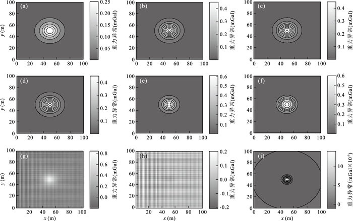
Downward continuation is an effective tool in the processing of potential field data, which can identify overlap anomalies and enhance weak anomalies effectively. But the existing computation methods of downward continuation easily distort the true feature of potential field data since they are unstable and sensitive to noise. In this paper, we present an iteration method based on horizontal derivative, and we prove that downward continuation can be computed by the combination of upward continuation and horizontal derivative, and the computation of upward continuation and horizontal derivative is stable, which confirms stability and reliability of the method. The proposed method has been tested on synthetic potential field data, and it is found that the output results are more stable and accurate than those computed by the Fourier transform, and more insensitive to noise. Its application to real potential field data shows the same results and it really enhances the local anomalies.
Downward continuation is an effective tool in the processing of potential field data, which can identify overlap anomalies and enhance weak anomalies effectively. But the existing computation methods of downward continuation easily distort the true feature of potential field data since they are unstable and sensitive to noise. In this paper, we present an iteration method based on horizontal derivative, and we prove that downward continuation can be computed by the combination of upward continuation and horizontal derivative, and the computation of upward continuation and horizontal derivative is stable, which confirms stability and reliability of the method. The proposed method has been tested on synthetic potential field data, and it is found that the output results are more stable and accurate than those computed by the Fourier transform, and more insensitive to noise. Its application to real potential field data shows the same results and it really enhances the local anomalies.


2016, 41(7): 1238-1248.
doi: 10.3799/dqkx.2016.102
Abstract:
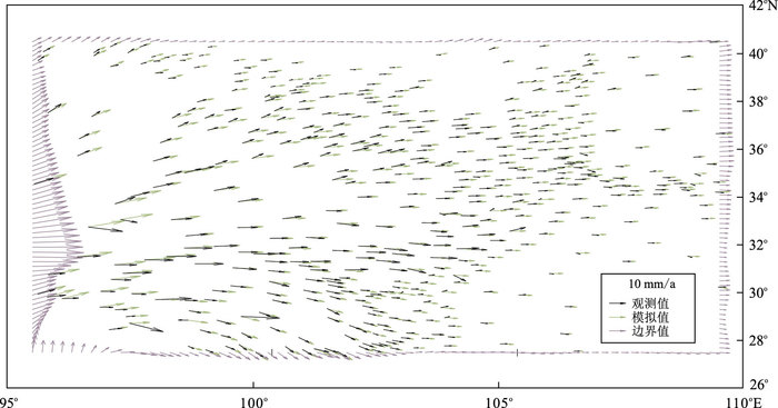
It is very important to study the influence of the strong earthquake on the surrounding fault and its development trend in future. Strong earthquakes occurred frequently in the northeastern margin of the Qinghai-Tibet Plateau, thus it is necessary to study the history of strong earthquakes in this region. We construct the 3D viscoelastic finite element model of the northwest margin and its surroundings of Qinghai-Tibet Plateau, on the basis of level Ⅰblocks in China continent and level Ⅱ blocks in Qinghai-Tibetan Plateau and distribution of active faults to determine the model block boundary and fault location in this paper. In addition, the dynamic process of strong earthquakes (Ms≥7.0) since 1900 is simulated using GPS observation data as boundary conditions, The calculation results are as follows. (1) The regional horizontal tectonic stress field in northeastern margin of Tibetan Plateau is characterized by gradual decrease from west to east and decrease from south to north as well. (2) The simulation results show that the strong earthquakes are mainly caused by the equivalent stress loaded on the background field and the strong earthquakes. (3) The effects of historical earthquake sequence to the earthquakes since 1970 are also discussed. It is concluded that the Kangding earthquake triggered the occurrence of Luhuo earthquake acceleratedly, while the effect of Kangding earthquake, Luhuo earthquake and Songpan earthquake on Gonghe earthquake is not obvious, meanwhile, the influence of Luhuo earthquake, Songpan earthquake and Gonghe earthquake on the Wenchuan earthquake is little; and the Wenchuan earthquake delayed the occurrence of Lushan earthquake.
It is very important to study the influence of the strong earthquake on the surrounding fault and its development trend in future. Strong earthquakes occurred frequently in the northeastern margin of the Qinghai-Tibet Plateau, thus it is necessary to study the history of strong earthquakes in this region. We construct the 3D viscoelastic finite element model of the northwest margin and its surroundings of Qinghai-Tibet Plateau, on the basis of level Ⅰblocks in China continent and level Ⅱ blocks in Qinghai-Tibetan Plateau and distribution of active faults to determine the model block boundary and fault location in this paper. In addition, the dynamic process of strong earthquakes (Ms≥7.0) since 1900 is simulated using GPS observation data as boundary conditions, The calculation results are as follows. (1) The regional horizontal tectonic stress field in northeastern margin of Tibetan Plateau is characterized by gradual decrease from west to east and decrease from south to north as well. (2) The simulation results show that the strong earthquakes are mainly caused by the equivalent stress loaded on the background field and the strong earthquakes. (3) The effects of historical earthquake sequence to the earthquakes since 1970 are also discussed. It is concluded that the Kangding earthquake triggered the occurrence of Luhuo earthquake acceleratedly, while the effect of Kangding earthquake, Luhuo earthquake and Songpan earthquake on Gonghe earthquake is not obvious, meanwhile, the influence of Luhuo earthquake, Songpan earthquake and Gonghe earthquake on the Wenchuan earthquake is little; and the Wenchuan earthquake delayed the occurrence of Lushan earthquake.


2016, 41(7): 1249-1258.
doi: 10.3799/dqkx.2016.103
Abstract:
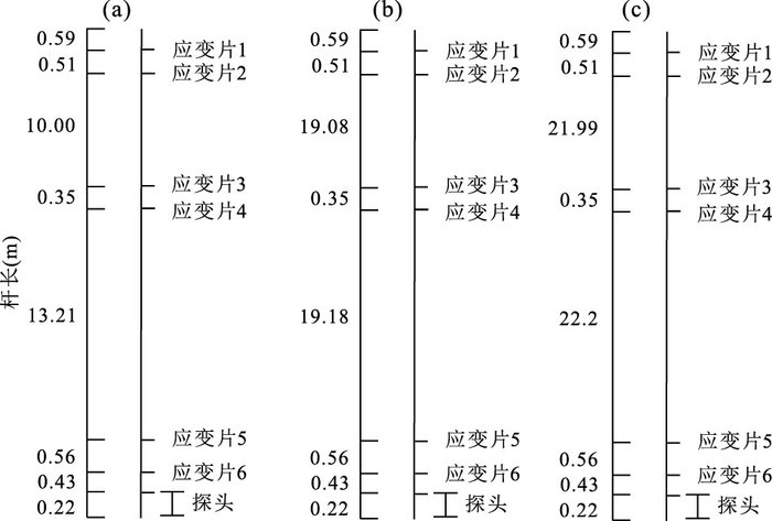
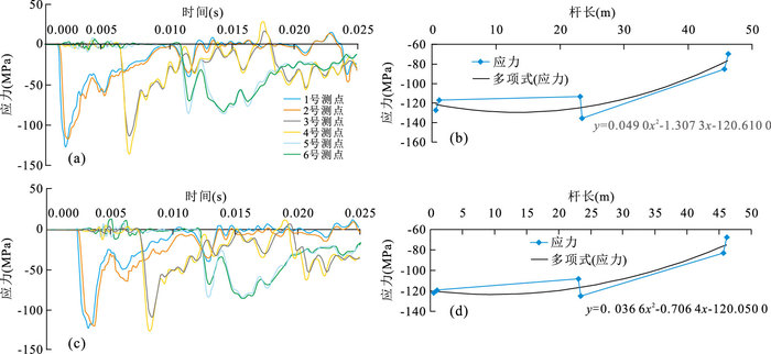
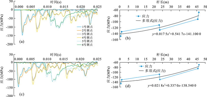
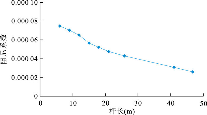
In the geotechnical investigation of hydropower projects in western China, exploratory sampling and engineering property research are challenging on account of the thick overburden on the riverbed. The dynamic penetration test(DPT) has become the preferred method of in-situ tests for the river overburden layers in western China due to its simple operation and applicability for different soil types. The current standard only provides a correction method for the rod length within 20 m. For the problems of adaptation and correction of heavy and extra-heavy dynamic penetration rod length, there is always much controversy but rare research for a long time. To address this issue, a study is conducted, involving the following procedures. Firstly, combined with the field test and numerical simulation, the stress value of each monitoring point is obtained by monitoring the rod of field DPT. Then, LS-DYNA software is used for inverse analysis and relevant parameters are determinined. Lastly, different rod lengths of DPT, such as 25 m, 40 m, 60 m, 80 m and 120 m, are simulated, and the adaptation and correction of rod length are obtained. The research method and results can be used for reference in similar problems and other geotechnical investigation practices in areas with deep river overburden layers.
In the geotechnical investigation of hydropower projects in western China, exploratory sampling and engineering property research are challenging on account of the thick overburden on the riverbed. The dynamic penetration test(DPT) has become the preferred method of in-situ tests for the river overburden layers in western China due to its simple operation and applicability for different soil types. The current standard only provides a correction method for the rod length within 20 m. For the problems of adaptation and correction of heavy and extra-heavy dynamic penetration rod length, there is always much controversy but rare research for a long time. To address this issue, a study is conducted, involving the following procedures. Firstly, combined with the field test and numerical simulation, the stress value of each monitoring point is obtained by monitoring the rod of field DPT. Then, LS-DYNA software is used for inverse analysis and relevant parameters are determinined. Lastly, different rod lengths of DPT, such as 25 m, 40 m, 60 m, 80 m and 120 m, are simulated, and the adaptation and correction of rod length are obtained. The research method and results can be used for reference in similar problems and other geotechnical investigation practices in areas with deep river overburden layers.