2016 Vol. 41, No. 8
Display Method:
 PDF 254KB
2016, 41(8): 1259-1274.
doi: 10.3799/dqkx.2016.104
Abstract:
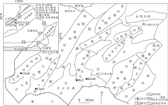
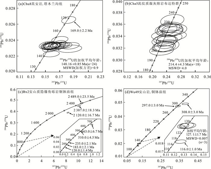
The Hailaer basin is located in the west of the Great Xing'an Range, and there are many sets of volcanic sedimentary rocks in the basin. Determining the age of the formation of volcanic rocks can provide reliable evidence for the stratigraphic correlation of the basin and the Great Xing'an Range, and the tectonic evolution in Northeast China as well. LA-ICP-MS zircon U-Pb dating for 4 volcanic rock samples from coring well in the Hailaer basin (HB) is presented in this paper. Their formation time and tectonic setting focusing on the intra-/inter-basinal stratigraphic correlation are discussed. The dating results show that volcanic rocks with ages of Late Triassic-early Early Jurassic (214.4±4.3 Ma) do exist in the HB. And the whole volcanic succession in the region can be subdivided into 4 stages of eruption including Middle-Late Carboniferous (320-290 Ma), Late Triassic-early Early Jurassic (224-197 Ma), Late Jurassic-early Early Cretaceous (152-138 Ma), and late Early Cretaceous (128-117 Ma). Combined with geochemical characteristics, temporal and spatial distribution characteristics of the magma in the Great Xing'an Range area, as well as the characteristics of the seismic profile of the basin, it is suggested that the Middle-Late Carboniferous magmatic rocks (320-290 Ma) were probably formed in a post-collision extensional setting related to the collision and merging of the Songnen and Ergun-Xing'an blocks. The Late Triassic-early Early Jurassic volcanic rocks (224-197 Ma) were probably formed in a post-collision extensional setting related to the closure of Paleo-Asian Ocean, which indicates Paleo-Asian Ocean tectonic domain affects the Great Xing'an Range area extended to the early Early Jurassic at least and the collision of the Mongolia Okhotsk Ocean possibly started in the early Jurassic at the earliest. The Late Jurassic-early Early Cretaceous (152-138 Ma) and the Late Early Cretaceous (128-117 Ma) volcanic rocks were probably formed in a post-collision extensional setting related to the closure of Mongolia Okhotsk Ocean. Some ages of Paleoproterozoic-Neoproterozoic zircon dating are obtained, which might have been captured from some crystal rocks of Proterozoic crystalline basement in the blocks underneath the HB.
The Hailaer basin is located in the west of the Great Xing'an Range, and there are many sets of volcanic sedimentary rocks in the basin. Determining the age of the formation of volcanic rocks can provide reliable evidence for the stratigraphic correlation of the basin and the Great Xing'an Range, and the tectonic evolution in Northeast China as well. LA-ICP-MS zircon U-Pb dating for 4 volcanic rock samples from coring well in the Hailaer basin (HB) is presented in this paper. Their formation time and tectonic setting focusing on the intra-/inter-basinal stratigraphic correlation are discussed. The dating results show that volcanic rocks with ages of Late Triassic-early Early Jurassic (214.4±4.3 Ma) do exist in the HB. And the whole volcanic succession in the region can be subdivided into 4 stages of eruption including Middle-Late Carboniferous (320-290 Ma), Late Triassic-early Early Jurassic (224-197 Ma), Late Jurassic-early Early Cretaceous (152-138 Ma), and late Early Cretaceous (128-117 Ma). Combined with geochemical characteristics, temporal and spatial distribution characteristics of the magma in the Great Xing'an Range area, as well as the characteristics of the seismic profile of the basin, it is suggested that the Middle-Late Carboniferous magmatic rocks (320-290 Ma) were probably formed in a post-collision extensional setting related to the collision and merging of the Songnen and Ergun-Xing'an blocks. The Late Triassic-early Early Jurassic volcanic rocks (224-197 Ma) were probably formed in a post-collision extensional setting related to the closure of Paleo-Asian Ocean, which indicates Paleo-Asian Ocean tectonic domain affects the Great Xing'an Range area extended to the early Early Jurassic at least and the collision of the Mongolia Okhotsk Ocean possibly started in the early Jurassic at the earliest. The Late Jurassic-early Early Cretaceous (152-138 Ma) and the Late Early Cretaceous (128-117 Ma) volcanic rocks were probably formed in a post-collision extensional setting related to the closure of Mongolia Okhotsk Ocean. Some ages of Paleoproterozoic-Neoproterozoic zircon dating are obtained, which might have been captured from some crystal rocks of Proterozoic crystalline basement in the blocks underneath the HB.


2016, 41(8): 1275-1294.
doi: 10.3799/dqkx.2016.507
Abstract:
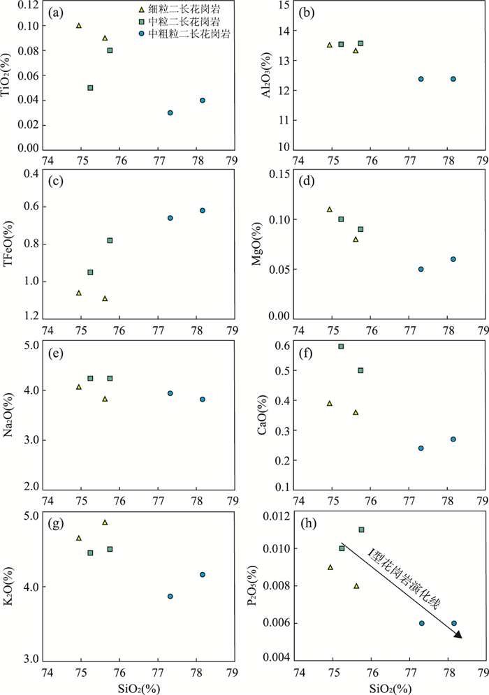
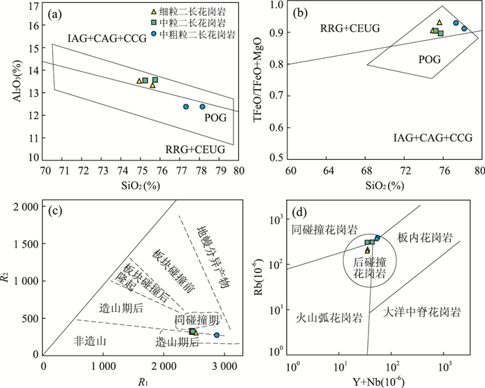
Xinxian monzogranites are located at the Qinling-Dabie orogenic belt, and a systematic geochemical study can facilitate further studies on the Mesozoic tectono-magmatic evolution and the geodynamics background of Qinling-Dabie orogenic belt. This paper presents geochemistry, zircon U-Pb geochronology, and Hf-isotopic data of the rocks, with the aim of constraining their petrogenesis, sources and tectonic implications. The geochemical analysis shows that Xinxian monzogranites are characterized by SiO2=74.94%-78.16%, K2O=3.87%-5.86%, Na2O=3.82%-4.24%, Al2O3=12.38%-13.57%, A/CNK=1.05-1.11; the rocks are enriched in LREE, depleted HREE and negative Eu anomalies, enriched in Rb, U, Hf, Y and depleted Ba, Nb, Ta, Ti, which indicates that Xinxian monzogranites are peraluminous, high-K calc-alkaline Ⅰ-type granite. The three stages yield LA-ICP-MS zircon U-Pb ages 153.4±1.1 Ma, 146.4±1.6 Ma and 131.6±1.8 Ma respectively. According to zircon Hf isotope analysis, the εHf(t) values of the granite range from -24.5 to -20.3, which locates below the depleted mantle line. The tDM2 values range from 2.68 to 2.93 Ga, which indicates the monzogranites resulted from the lower crust of Yangtze Block. The component of the monzogranite is similar to that of Neoproterozoic TTG magmatic rocks. Xinxian monzogranites were emplaced after the major collisional period of the North China block and Yangtze block, in the post-collisional tectonic setting under the regional extension mechanism. The geodynamics setting is the transformation of tectonic regime of the Late Jurassic-Early Cretaceous and large-scale lithosphere delaminating thinning under post stretching mechanism.
Xinxian monzogranites are located at the Qinling-Dabie orogenic belt, and a systematic geochemical study can facilitate further studies on the Mesozoic tectono-magmatic evolution and the geodynamics background of Qinling-Dabie orogenic belt. This paper presents geochemistry, zircon U-Pb geochronology, and Hf-isotopic data of the rocks, with the aim of constraining their petrogenesis, sources and tectonic implications. The geochemical analysis shows that Xinxian monzogranites are characterized by SiO2=74.94%-78.16%, K2O=3.87%-5.86%, Na2O=3.82%-4.24%, Al2O3=12.38%-13.57%, A/CNK=1.05-1.11; the rocks are enriched in LREE, depleted HREE and negative Eu anomalies, enriched in Rb, U, Hf, Y and depleted Ba, Nb, Ta, Ti, which indicates that Xinxian monzogranites are peraluminous, high-K calc-alkaline Ⅰ-type granite. The three stages yield LA-ICP-MS zircon U-Pb ages 153.4±1.1 Ma, 146.4±1.6 Ma and 131.6±1.8 Ma respectively. According to zircon Hf isotope analysis, the εHf(t) values of the granite range from -24.5 to -20.3, which locates below the depleted mantle line. The tDM2 values range from 2.68 to 2.93 Ga, which indicates the monzogranites resulted from the lower crust of Yangtze Block. The component of the monzogranite is similar to that of Neoproterozoic TTG magmatic rocks. Xinxian monzogranites were emplaced after the major collisional period of the North China block and Yangtze block, in the post-collisional tectonic setting under the regional extension mechanism. The geodynamics setting is the transformation of tectonic regime of the Late Jurassic-Early Cretaceous and large-scale lithosphere delaminating thinning under post stretching mechanism.


2016, 41(8): 1295-1308, 1321.
doi: 10.3799/dqkx.2016.105
Abstract:
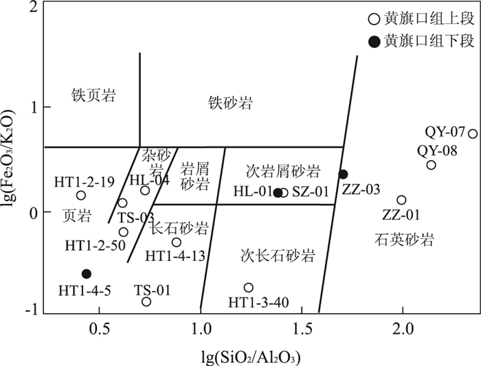
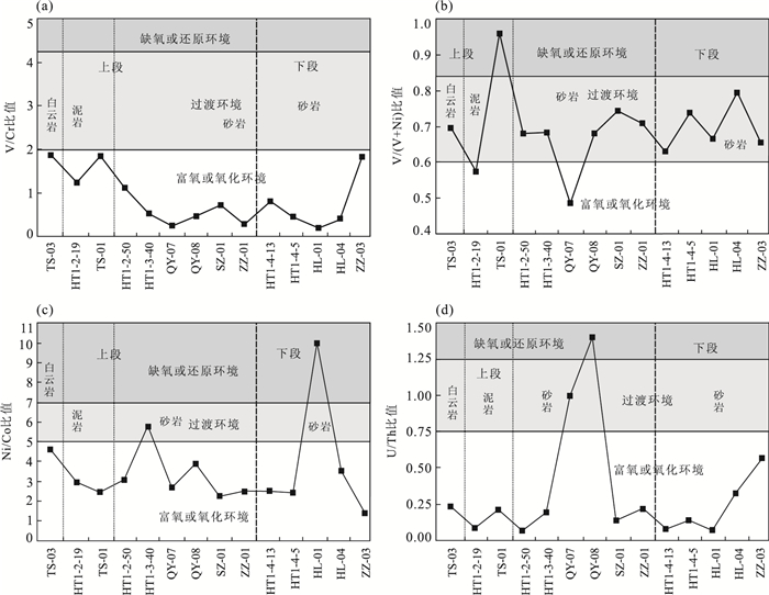
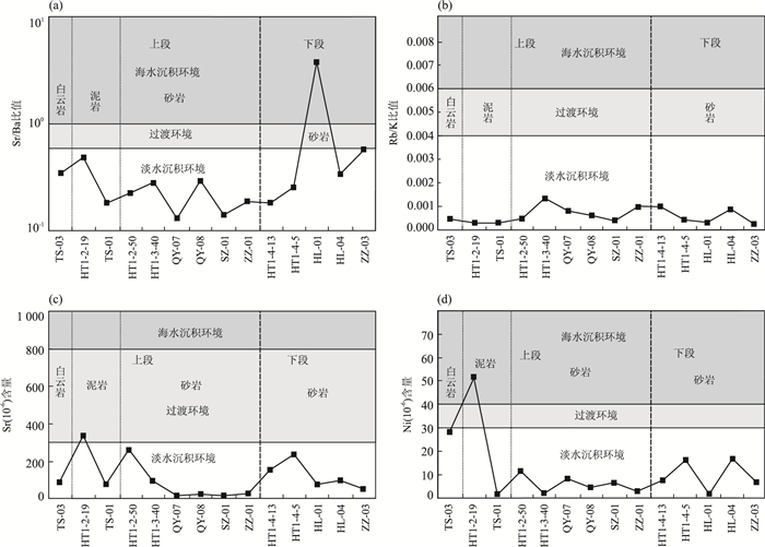
A set of ultra-thick Middle Proterozoic clastic sedimentary rocks deposited in and around southwestern Ordos basin, with the Huangqikou Formation(HKF) as the most typical one, has great potential for oil and gas exploration. However, our understanding of HKF needs to be enhanced. Thus, by means of main-trace, rare elements and detrital component method, we probed into the sedimentary environment and tectonic setting of the HKF. The sedimentary environment discrimination diagrams of both main and trace elements show that the HKF was deposited wholly under a dry environment with fresh water oxidized, or an oxygen-enriched environment, with an average paleoseawater temperature of 32 ℃. The tectonic environment discrimination diagrams of clastic composition, and main and trace elements all show similarity to those of the East African rift basin, and gradual increasing of the quartz sandstone content from the lower to the upper parts, suggesting that HKF deposited under an intracontinental rift tectonic-sedimentary setting, which may have been caused by the counterclockwise rotation of North China Craton. It is concluded that the HKF was deposited in an intracontinental rift basin in the fresh water, and the tectonic setting became more stable from early to late stage, which was intra-continental rift in the early stage and post-rift depression in the late one.
A set of ultra-thick Middle Proterozoic clastic sedimentary rocks deposited in and around southwestern Ordos basin, with the Huangqikou Formation(HKF) as the most typical one, has great potential for oil and gas exploration. However, our understanding of HKF needs to be enhanced. Thus, by means of main-trace, rare elements and detrital component method, we probed into the sedimentary environment and tectonic setting of the HKF. The sedimentary environment discrimination diagrams of both main and trace elements show that the HKF was deposited wholly under a dry environment with fresh water oxidized, or an oxygen-enriched environment, with an average paleoseawater temperature of 32 ℃. The tectonic environment discrimination diagrams of clastic composition, and main and trace elements all show similarity to those of the East African rift basin, and gradual increasing of the quartz sandstone content from the lower to the upper parts, suggesting that HKF deposited under an intracontinental rift tectonic-sedimentary setting, which may have been caused by the counterclockwise rotation of North China Craton. It is concluded that the HKF was deposited in an intracontinental rift basin in the fresh water, and the tectonic setting became more stable from early to late stage, which was intra-continental rift in the early stage and post-rift depression in the late one.


2016, 41(8): 1309-1321.
doi: 10.3799/dqkx.2016.106
Abstract:
The tectono-magmatic thermal event of Emeishan Large Igneous Province (ELIP) and the formation of Sanjiang Orogen caused by closure of Paleo-Tethys ocean along the western margin of the Upper Yangtze area during Late Paleozoic to Early Mesozoic shaped the unique pattern of basin-mountain system. For lack of cognition about the provenance and tectonic settings of Qingtianbao Formation in Yanyuan area, southwestern Sichuan, detrital compositions, major, trace elements and detrital zircon isotope ages of clastic rocks from Yantang section were tested and analyzed. The detrital components of Sandstone in Yanyuan region is volcanic clastic mainly and suggests that the provenance of Early Triassic strata was from a nearly source of volcanic rock, detrital zircons yield U-Pb ages of ca. 261 Ma is consistent with the Emeishan mantle plume activity event and the geochemical characteristics of sandstone is similarity to those High Ti basalt of Emeishan LIP. Combined with the research findings of sedimentary and palaeo-geography in Yanyuan area, we suggest that the provenance of Qingtianbao Formation in Yanyuan region came from the Emeishan LIP, but may not came from the Sanjiang Orogen. Southwestern Upper Yangtze area was still a passive continental margin.
The tectono-magmatic thermal event of Emeishan Large Igneous Province (ELIP) and the formation of Sanjiang Orogen caused by closure of Paleo-Tethys ocean along the western margin of the Upper Yangtze area during Late Paleozoic to Early Mesozoic shaped the unique pattern of basin-mountain system. For lack of cognition about the provenance and tectonic settings of Qingtianbao Formation in Yanyuan area, southwestern Sichuan, detrital compositions, major, trace elements and detrital zircon isotope ages of clastic rocks from Yantang section were tested and analyzed. The detrital components of Sandstone in Yanyuan region is volcanic clastic mainly and suggests that the provenance of Early Triassic strata was from a nearly source of volcanic rock, detrital zircons yield U-Pb ages of ca. 261 Ma is consistent with the Emeishan mantle plume activity event and the geochemical characteristics of sandstone is similarity to those High Ti basalt of Emeishan LIP. Combined with the research findings of sedimentary and palaeo-geography in Yanyuan area, we suggest that the provenance of Qingtianbao Formation in Yanyuan region came from the Emeishan LIP, but may not came from the Sanjiang Orogen. Southwestern Upper Yangtze area was still a passive continental margin.


2016, 41(8): 1322-1333.
doi: 10.3799/dqkx.2016.517
Abstract:
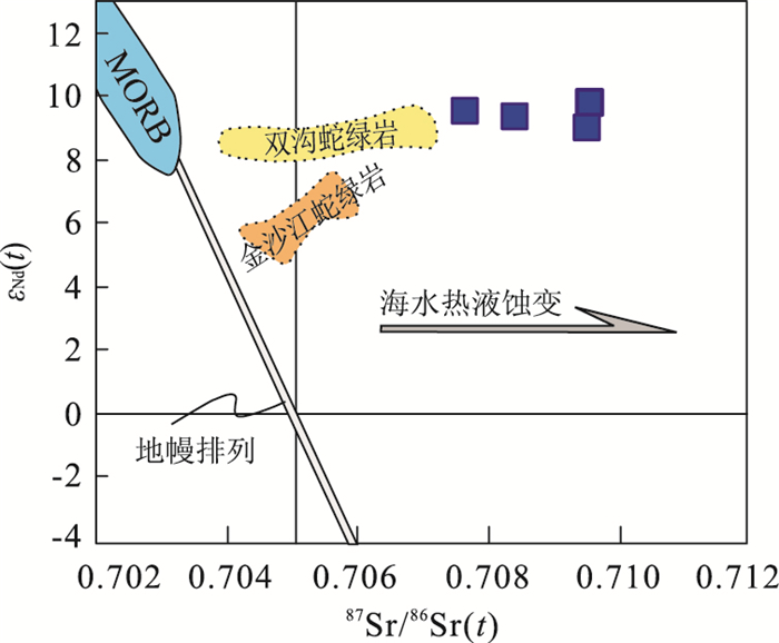
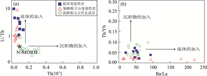
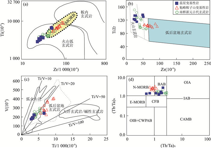
A medium and high grade metamorphic rock series is exposed in Longyou area located in the southeast margin of Yangtze block and Cathaysia block, which is important for the interpretation of South China Predevonian tectonic pattern. But the tectonic setting of its formation remains unknown presently. It is found out these rocks can be divided into three types: "N-MORB", "T-MORB" and "E-MORB" type rock by a basic and magnesian metamorphic rock geochemical study in this paper The protoliths of the "N-MORB" is mainly formed in the intra-oceanic arc, the "T-MORB" is mainly formed in the transition of mid-oceanic ridge and the volcanic arc, and the "E-MORB" type rock is formed in the enrichment of mid-oceanic ridge, epicontinental arc and intraplate environment. Rock diagenesis environment diversity shows that the metamorphic rock of Longyou area is a tectonic mélange and its forming process is related with the ancient oceanic crust subduction, which also provides a reasonable explanation for the output, positioning of the pomegranate amphibolite in Longyou area.
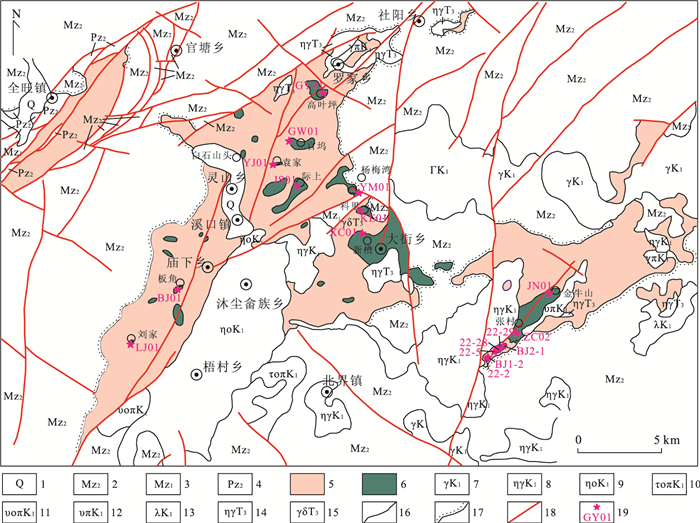
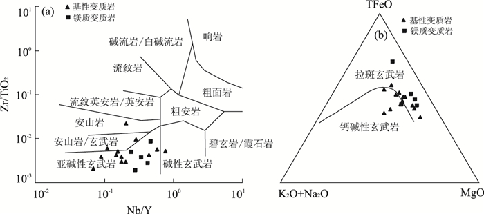
A medium and high grade metamorphic rock series is exposed in Longyou area located in the southeast margin of Yangtze block and Cathaysia block, which is important for the interpretation of South China Predevonian tectonic pattern. But the tectonic setting of its formation remains unknown presently. It is found out these rocks can be divided into three types: "N-MORB", "T-MORB" and "E-MORB" type rock by a basic and magnesian metamorphic rock geochemical study in this paper The protoliths of the "N-MORB" is mainly formed in the intra-oceanic arc, the "T-MORB" is mainly formed in the transition of mid-oceanic ridge and the volcanic arc, and the "E-MORB" type rock is formed in the enrichment of mid-oceanic ridge, epicontinental arc and intraplate environment. Rock diagenesis environment diversity shows that the metamorphic rock of Longyou area is a tectonic mélange and its forming process is related with the ancient oceanic crust subduction, which also provides a reasonable explanation for the output, positioning of the pomegranate amphibolite in Longyou area.


2016, 41(8): 1334-1348.
doi: 10.3799/dqkx.2016.520
Abstract:
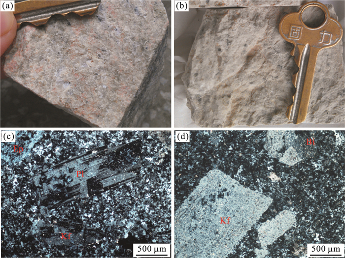
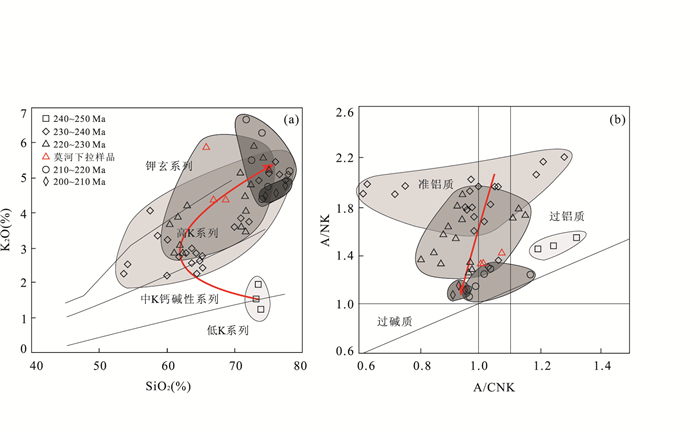
The East Kunlun orogenic belt is not only an important intrusive magmatic tectonic belt, but also a very important poly-metallic metallogenic belt for national economy. There are a large number of granites associated with mineralization formed in Triassic in this area, but the connection between them and the relationship about the tectogenesis are still not clear. In this paper, detailed petrography, element geochemical and zircon geochronological studies are presented for the Mohexiala granite-porphyry associated with silver poly-metallic ore; we summarize the characteristics of Triassic granites associated with mineralization within the East Kunlun orogenic belt, and discuss their evolution. Results show that: (1) the Triassic granites associated with mineralization within East Kunlun orogenic belt have a clear trend from low-K and mid-K calc-alkaline series to high-K calc-alkaline and shoshonite series during 250-200 Ma, their A/NK ratios decreased from 2.0 to 1.0 during 240-200 Ma; (2) the (87Sr/86Sr)i ratios between 0.710 to 0.715, εNd(t)=-0.6-0.0, the value of εHf(t) are concentrated in -5-1 and the peak ranges between -2 to -1, indicating that the East Kunlun Triassic granites associated with mineralization were derived from the sources of ancient crust and mixed by mantle material; (3) the East Kunlun area got into the post-orogenic stage at 240 Ma and a large number of calc-alkaline granites formed, the granites gradually reduced after 220 Ma and some alkaline A-type granites occurred between 204 Ma and 210 Ma which indicates that the orogenic belt transformed from collision-orogeny to the intraplate break-up stage.
The East Kunlun orogenic belt is not only an important intrusive magmatic tectonic belt, but also a very important poly-metallic metallogenic belt for national economy. There are a large number of granites associated with mineralization formed in Triassic in this area, but the connection between them and the relationship about the tectogenesis are still not clear. In this paper, detailed petrography, element geochemical and zircon geochronological studies are presented for the Mohexiala granite-porphyry associated with silver poly-metallic ore; we summarize the characteristics of Triassic granites associated with mineralization within the East Kunlun orogenic belt, and discuss their evolution. Results show that: (1) the Triassic granites associated with mineralization within East Kunlun orogenic belt have a clear trend from low-K and mid-K calc-alkaline series to high-K calc-alkaline and shoshonite series during 250-200 Ma, their A/NK ratios decreased from 2.0 to 1.0 during 240-200 Ma; (2) the (87Sr/86Sr)i ratios between 0.710 to 0.715, εNd(t)=-0.6-0.0, the value of εHf(t) are concentrated in -5-1 and the peak ranges between -2 to -1, indicating that the East Kunlun Triassic granites associated with mineralization were derived from the sources of ancient crust and mixed by mantle material; (3) the East Kunlun area got into the post-orogenic stage at 240 Ma and a large number of calc-alkaline granites formed, the granites gradually reduced after 220 Ma and some alkaline A-type granites occurred between 204 Ma and 210 Ma which indicates that the orogenic belt transformed from collision-orogeny to the intraplate break-up stage.


2016, 41(8): 1349-1360.
doi: 10.3799/dqkx.2016.107
Abstract:
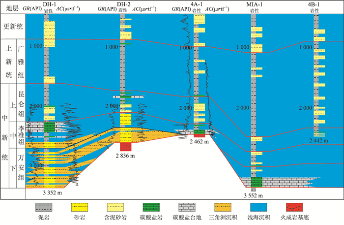
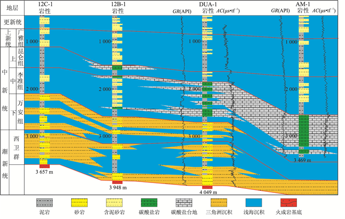
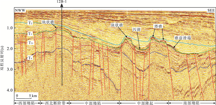
The reef and carbonate platform is one of the most important reservoirs in the south of South China Sea, and the reefs and the sedimentary facies of carbonate platform in the Wan'an basin should be further studied. The high-resolution seismic profiles associated with well data in this paper facilitate the understanding of the reefs and carbonate platforms in the study area. The evolution of reefs and carbonate platform can be divided into four stages. In Early Miocene, a few isolated carbonate platforms that were small in size firstly initiated in center of this basin. They flourished in Middle Miocene and mainly developed around the Northern Uplift, Central Uplift. Transversely, two bands there, namely western band and eastern band, were the distinct characteristic of its spatial distributions in this time. Platform-edge reef and massive reef were the main style of reef and there were also a few point reefs developing on the edge of carbonate platform. In Late Miocene, the carbonate platforms began to backstep to elevated topographic positions in response to a relative sea level rise. While, the number and style of reef increased in this stage, such as platform-edge reef, massive reef, atoll reef and point reef. Tectonics and eustasy are the two main controlling factors on platform development. Tectonics mainly controlled both the initial topography for reef growth and the distribution of platforms, and eustasy controlled carbonate sequence development. Since the Late Miocene, the rapid tectonic subsidence and the rise of relative sea-level should have led to the drowning of carbonate platform.
The reef and carbonate platform is one of the most important reservoirs in the south of South China Sea, and the reefs and the sedimentary facies of carbonate platform in the Wan'an basin should be further studied. The high-resolution seismic profiles associated with well data in this paper facilitate the understanding of the reefs and carbonate platforms in the study area. The evolution of reefs and carbonate platform can be divided into four stages. In Early Miocene, a few isolated carbonate platforms that were small in size firstly initiated in center of this basin. They flourished in Middle Miocene and mainly developed around the Northern Uplift, Central Uplift. Transversely, two bands there, namely western band and eastern band, were the distinct characteristic of its spatial distributions in this time. Platform-edge reef and massive reef were the main style of reef and there were also a few point reefs developing on the edge of carbonate platform. In Late Miocene, the carbonate platforms began to backstep to elevated topographic positions in response to a relative sea level rise. While, the number and style of reef increased in this stage, such as platform-edge reef, massive reef, atoll reef and point reef. Tectonics and eustasy are the two main controlling factors on platform development. Tectonics mainly controlled both the initial topography for reef growth and the distribution of platforms, and eustasy controlled carbonate sequence development. Since the Late Miocene, the rapid tectonic subsidence and the rise of relative sea-level should have led to the drowning of carbonate platform.


2016, 41(8): 1361-1375.
doi: 10.3799/dqkx.2016.108
Abstract:
Hainan Island, located between the Indochina and South China Blocks, has undergone compound structural overprinting and complex tectonic evolution. However, the Late Paleozoic tectonic regime and amalgamation history of the South China with Indochina Blocks are still on debate. Our investigation identified the highly-depleted greenschist-facies basalt at the Chenxing area in the north of the Changjiang-Qionghai fault, Central Hainan Island. This paper presents a set of new geochronological and geochemical data for these metabasites. The representative sample for Chenxing metabasites gave the plateau age of 328.1±2.6 Ma, representing the eruption age. They have SiO2 ranging from 46.92 % to 52.58 %, TiO2 from 0.48 % to 1.12% and Al2O3 from 12.34 % to 17.45 %, and could be classified as basalt. These samples show lower K2O contents, and HFSEs and REEs contents relative to N-MORB. They are characterized by the left-sloping REE pattern and multi-elemental pattern with a geochemical affinity to N-MORB. These samples show extremely high εNd(t) values ranging from 9.02 to 9.85. Such geochemical characteristics for the Chenxing metabasites show the derivation of the MORB source modified by slab-related fluid. In combination with other available data, the Chenxing metabasites in Central Hainan are formed in the back-arc basin or a restricted ocean basin between the South China and Indochina blocks during the Carboniferous in response to the subduction of the Paleotethyan main ocean.
Hainan Island, located between the Indochina and South China Blocks, has undergone compound structural overprinting and complex tectonic evolution. However, the Late Paleozoic tectonic regime and amalgamation history of the South China with Indochina Blocks are still on debate. Our investigation identified the highly-depleted greenschist-facies basalt at the Chenxing area in the north of the Changjiang-Qionghai fault, Central Hainan Island. This paper presents a set of new geochronological and geochemical data for these metabasites. The representative sample for Chenxing metabasites gave the plateau age of 328.1±2.6 Ma, representing the eruption age. They have SiO2 ranging from 46.92 % to 52.58 %, TiO2 from 0.48 % to 1.12% and Al2O3 from 12.34 % to 17.45 %, and could be classified as basalt. These samples show lower K2O contents, and HFSEs and REEs contents relative to N-MORB. They are characterized by the left-sloping REE pattern and multi-elemental pattern with a geochemical affinity to N-MORB. These samples show extremely high εNd(t) values ranging from 9.02 to 9.85. Such geochemical characteristics for the Chenxing metabasites show the derivation of the MORB source modified by slab-related fluid. In combination with other available data, the Chenxing metabasites in Central Hainan are formed in the back-arc basin or a restricted ocean basin between the South China and Indochina blocks during the Carboniferous in response to the subduction of the Paleotethyan main ocean.


2016, 41(8): 1376-1383.
doi: 10.3799/dqkx.2016.522
Abstract:
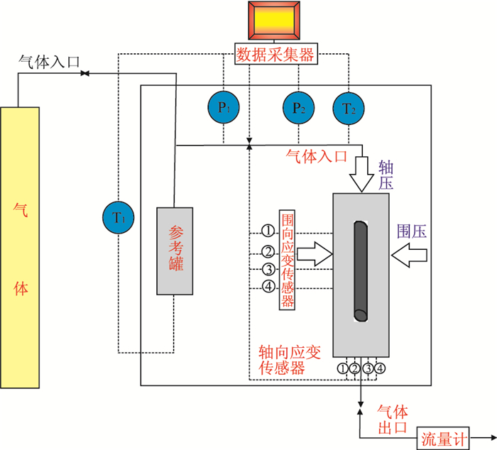
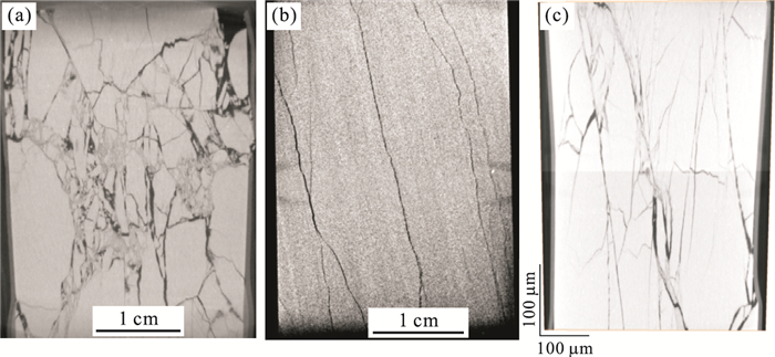
The mechanisms of permeability variations and fracture extension are essential for hydraulic fracturing design in shale gas exploitation. Based on fluid-solid coupling physical experiments and Micro-CT imaging analysis, this study reveals two important phenomena: (1) loading-unloading-reloading cycle has an effect on increasing the permeability of shale samples, (2) during the reloading process, the permeability of shale samples show different trends with increasing axial pressure. In the permeability increasing case with increasing axial pressure, the fractures are produced directionally and orderly. In another case, the fractures are produced disorderly and locally mylonitic. The results show that (1) pumping-intermission-repumping multi-cycles could help modify the stimulation effect of in-site fracturing operations, and (2) hydraulic fracturing volume should be appropriately controlled for naturally fractured shale gas reservoirs.
The mechanisms of permeability variations and fracture extension are essential for hydraulic fracturing design in shale gas exploitation. Based on fluid-solid coupling physical experiments and Micro-CT imaging analysis, this study reveals two important phenomena: (1) loading-unloading-reloading cycle has an effect on increasing the permeability of shale samples, (2) during the reloading process, the permeability of shale samples show different trends with increasing axial pressure. In the permeability increasing case with increasing axial pressure, the fractures are produced directionally and orderly. In another case, the fractures are produced disorderly and locally mylonitic. The results show that (1) pumping-intermission-repumping multi-cycles could help modify the stimulation effect of in-site fracturing operations, and (2) hydraulic fracturing volume should be appropriately controlled for naturally fractured shale gas reservoirs.


2016, 41(8): 1384-1394.
doi: 10.3799/dqkx.2016.109
Abstract:
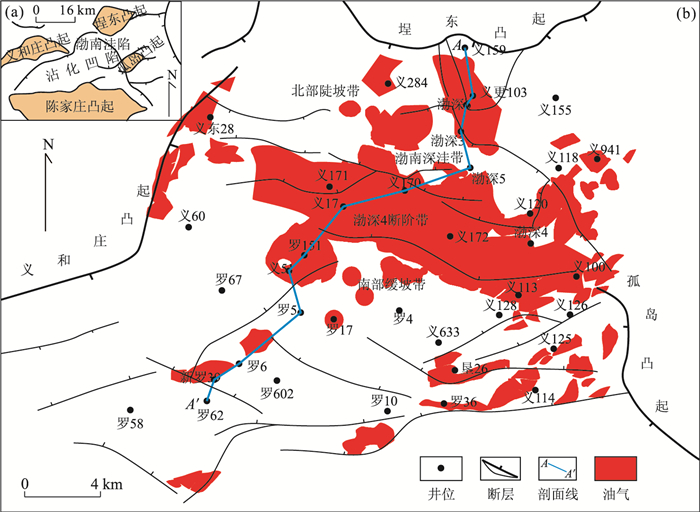
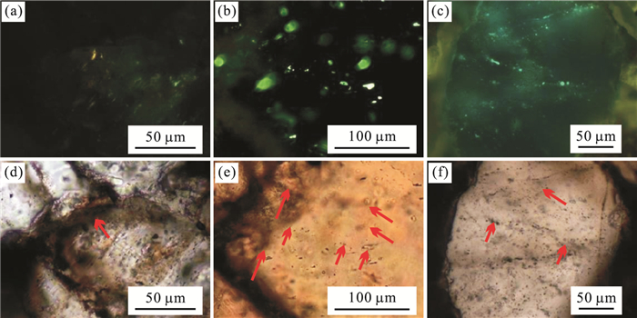
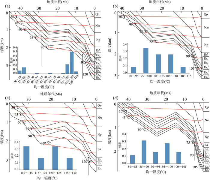
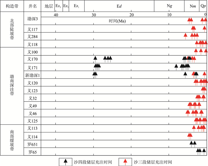
Bonan sag is rich in oil and gas resources, yet its complicated accumulation process results in a poor understanding of its dynamic conditions during hydrocarbon accumulation. In this study, the fluid pressure in the hydrocarbon accumulation period was recovered in the Bonan sag using such fluid inclusion analysis techniques as microscopic fluorescence, homogenization temperature and freezing point. The results show that the fluorescence of hydrocarbon inclusions in Es3 Member reservoir is yellow-white, and yellow-green, and the homogenization temperatures of fluid inclusions are 80-130 ℃, indicating that hydrocarbons were accumulated during the period from the middle and late stage of Minghuazhen Formation deposition to present. Whereas the fluorescence of hydrocarbon inclusions in the Es4 Member reservoirs is yellow, yellow-green and blue-green, and the homogenization temperatures of fluid inclusions are 70-80 ℃ and 90-130 ℃, corresponding to the two stages of hydrocarbon accumulation, namely the Dongying stage and the early stage of Minghuazhen to present, of which the latter is dominant. Meanwhile, reservoirs were generally with abnormal pressure in the period of hydrocarbon accumulation on a large scale. In the first period of hydrocarbon charging, the hydrocarbon generation was limited with the weak pressure coefficient, but in the second period of hydrocarbon charging, due to a large amount of hydrocarbons generated by the matured source rocks, the abnormal pressure gradually increased, the overpressure area enlarged, and the formation pressure coefficient reached 1.80. The overpressure could have provided sufficient driving force, and affected the directions of hydrocarbon migration and accumulation.
Bonan sag is rich in oil and gas resources, yet its complicated accumulation process results in a poor understanding of its dynamic conditions during hydrocarbon accumulation. In this study, the fluid pressure in the hydrocarbon accumulation period was recovered in the Bonan sag using such fluid inclusion analysis techniques as microscopic fluorescence, homogenization temperature and freezing point. The results show that the fluorescence of hydrocarbon inclusions in Es3 Member reservoir is yellow-white, and yellow-green, and the homogenization temperatures of fluid inclusions are 80-130 ℃, indicating that hydrocarbons were accumulated during the period from the middle and late stage of Minghuazhen Formation deposition to present. Whereas the fluorescence of hydrocarbon inclusions in the Es4 Member reservoirs is yellow, yellow-green and blue-green, and the homogenization temperatures of fluid inclusions are 70-80 ℃ and 90-130 ℃, corresponding to the two stages of hydrocarbon accumulation, namely the Dongying stage and the early stage of Minghuazhen to present, of which the latter is dominant. Meanwhile, reservoirs were generally with abnormal pressure in the period of hydrocarbon accumulation on a large scale. In the first period of hydrocarbon charging, the hydrocarbon generation was limited with the weak pressure coefficient, but in the second period of hydrocarbon charging, due to a large amount of hydrocarbons generated by the matured source rocks, the abnormal pressure gradually increased, the overpressure area enlarged, and the formation pressure coefficient reached 1.80. The overpressure could have provided sufficient driving force, and affected the directions of hydrocarbon migration and accumulation.


2016, 41(8): 1395-1401.
doi: 10.3799/dqkx.2016.110
Abstract:
The deep-sea hydrothermal metallic deposits are located on seafloor at depth about several kilometers, and it is difficult to determine their shape, scale and electrical parameters, and the electrical structure based on field data remains unknown. Using research vessel "DaYang-Ⅰ", several detection tests were implemented at Atlantic ridge and Southwest Indian ridge, and the electromagnetic response data of deep-sea hydrothermal metallic sulfide deposits have been observed and analyzed. The analysis show that in the Atlantic TAG (trans-Atlantic geotraverse) hydrothermal area and Southwest Indian Ocean 49°4′E, 37°5′S hydrothermal area, deep-sea hydrothermal metallic sulfide deposits are like'mushroom' in the oceanic crust, located in the brine pool around the hydrothermal vents with lenticular structure or stratoid structure, the resistivity is about 0.1 Ω·m, the scale changes from 50 to 250 m, and the thickness is from 20 to 50 m. The diameter of hydrothermal channel ranges from 10 to 50 m, and hydrothermal alternation took place within and outside the hydrothermal channel. The resistivity of the alternation rocks is in the range of 0.2 to 0.5 Ω·m, and concentrically changes around the hydrothermal channel. Based on the shape and electrical parameters of hydrothermal metallic sulfide deposits, the ore body can be simplified as a T-shaped target for electrical structure model.
The deep-sea hydrothermal metallic deposits are located on seafloor at depth about several kilometers, and it is difficult to determine their shape, scale and electrical parameters, and the electrical structure based on field data remains unknown. Using research vessel "DaYang-Ⅰ", several detection tests were implemented at Atlantic ridge and Southwest Indian ridge, and the electromagnetic response data of deep-sea hydrothermal metallic sulfide deposits have been observed and analyzed. The analysis show that in the Atlantic TAG (trans-Atlantic geotraverse) hydrothermal area and Southwest Indian Ocean 49°4′E, 37°5′S hydrothermal area, deep-sea hydrothermal metallic sulfide deposits are like'mushroom' in the oceanic crust, located in the brine pool around the hydrothermal vents with lenticular structure or stratoid structure, the resistivity is about 0.1 Ω·m, the scale changes from 50 to 250 m, and the thickness is from 20 to 50 m. The diameter of hydrothermal channel ranges from 10 to 50 m, and hydrothermal alternation took place within and outside the hydrothermal channel. The resistivity of the alternation rocks is in the range of 0.2 to 0.5 Ω·m, and concentrically changes around the hydrothermal channel. Based on the shape and electrical parameters of hydrothermal metallic sulfide deposits, the ore body can be simplified as a T-shaped target for electrical structure model.


2016, 41(8): 1402-1412.
doi: 10.3799/dqkx.2016.111
Abstract:
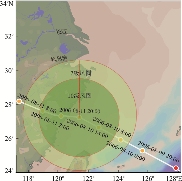
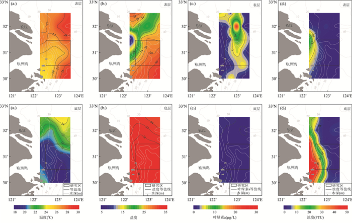
Typhoon is an important dynamic factor for short-term changes in the marine environment, which have a huge impact on the coastal estuarine environment. Based on the filed observation offshore near Yangtze Estuary before and after the typhoon "Saomai", the variations of water environment factors were analyzed in horizontal and vertical distribution. The results show that the temperature, salinity, chlorophyll a and turbidity changes were largely due to the advection transport and vertical mixing in the water body caused by the typhoon. The surface water temperature decreased and salinity increased, whereas the bottom water temperature increased and salinity decreased. The thickness of thermocline increased and stratifications got weaker than those before the typhoon, and the halocline almost disappeared in eastern area. The vertical transport of nutrient enhanced, causing an increase of the chlorophyll a. After the typhoon, the bottom cold water from the Taiwan warm current rose clearly in coastal area, and the upwelling feature was more significant, and the center of the Taiwan warm current in the bottom shifted eastward. The water turbidity decreased, especially in the shallow coastal waters, fine-grained sediments were flow transported by stronger advection.
Typhoon is an important dynamic factor for short-term changes in the marine environment, which have a huge impact on the coastal estuarine environment. Based on the filed observation offshore near Yangtze Estuary before and after the typhoon "Saomai", the variations of water environment factors were analyzed in horizontal and vertical distribution. The results show that the temperature, salinity, chlorophyll a and turbidity changes were largely due to the advection transport and vertical mixing in the water body caused by the typhoon. The surface water temperature decreased and salinity increased, whereas the bottom water temperature increased and salinity decreased. The thickness of thermocline increased and stratifications got weaker than those before the typhoon, and the halocline almost disappeared in eastern area. The vertical transport of nutrient enhanced, causing an increase of the chlorophyll a. After the typhoon, the bottom cold water from the Taiwan warm current rose clearly in coastal area, and the upwelling feature was more significant, and the center of the Taiwan warm current in the bottom shifted eastward. The water turbidity decreased, especially in the shallow coastal waters, fine-grained sediments were flow transported by stronger advection.


2016, 41(8): 1413-1423.
doi: 10.3799/dqkx.2016.112
Abstract:
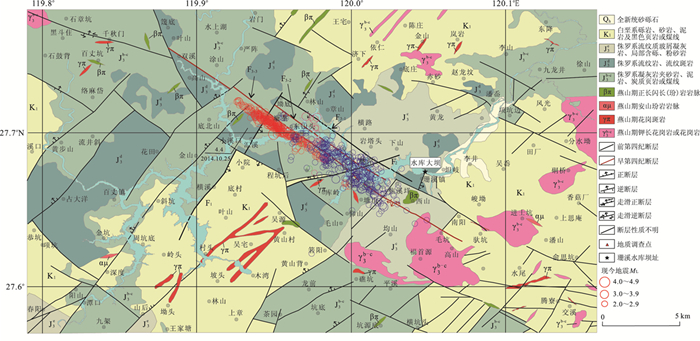
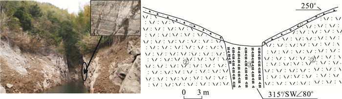
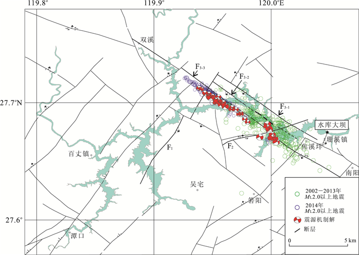
The Wenzhou Shanxi reservoir-induced earthquake has been active since its first occured in July 2002. However, less is known about the genesis of Shanxi reservoir-induced earthquake. Based on the analysis of regional seismic geological background, reservoir topography, geomorphology, lithology and new tectonic movement characteristics, the reservoir area's geological characteristics of the main faults were obtained and its permeability was evaluated by using field geological survey method. On this basis, time series and mechanism of the earthquake were discussed in combination with the study of seismicity and focal mechanism solutions. Finally we concluded that the earthquakes activities in Shanxi reservoir were closely related to the lithology, fault (especially the Shuangxi-Jiaoxiyang fault) and water in the reservoir. The earthquakes occurred mainly in Jurassic sandstone, mudstone rock tuff, etc. which belong to aquifuge tuff, while the structure plane in Shuangxi-Jiaoxiyang fault is beneficial to the infiltration of the reservoir water. This combination of rock mass structural plane induced, on the one hand, easy infiltration of the reservoir water to the deep underground through the fault, on the other hand, the increase of pore pressure on the fault structure plane. Therefore, the normal stress was reduced on the fault structure plane, and the stress balance was broken, which induced the occurrence of the earthquake activities finnally. Under the double influence of water infiltration and earthquake activity, the earthquakes contiuously occured from southeast to northwest along the Shuangxi-Jiaoxiyang fault (especially the third branch fault).
The Wenzhou Shanxi reservoir-induced earthquake has been active since its first occured in July 2002. However, less is known about the genesis of Shanxi reservoir-induced earthquake. Based on the analysis of regional seismic geological background, reservoir topography, geomorphology, lithology and new tectonic movement characteristics, the reservoir area's geological characteristics of the main faults were obtained and its permeability was evaluated by using field geological survey method. On this basis, time series and mechanism of the earthquake were discussed in combination with the study of seismicity and focal mechanism solutions. Finally we concluded that the earthquakes activities in Shanxi reservoir were closely related to the lithology, fault (especially the Shuangxi-Jiaoxiyang fault) and water in the reservoir. The earthquakes occurred mainly in Jurassic sandstone, mudstone rock tuff, etc. which belong to aquifuge tuff, while the structure plane in Shuangxi-Jiaoxiyang fault is beneficial to the infiltration of the reservoir water. This combination of rock mass structural plane induced, on the one hand, easy infiltration of the reservoir water to the deep underground through the fault, on the other hand, the increase of pore pressure on the fault structure plane. Therefore, the normal stress was reduced on the fault structure plane, and the stress balance was broken, which induced the occurrence of the earthquake activities finnally. Under the double influence of water infiltration and earthquake activity, the earthquakes contiuously occured from southeast to northwest along the Shuangxi-Jiaoxiyang fault (especially the third branch fault).


2016, 41(8): 1424-1434.
doi: 10.3799/dqkx.2016.113
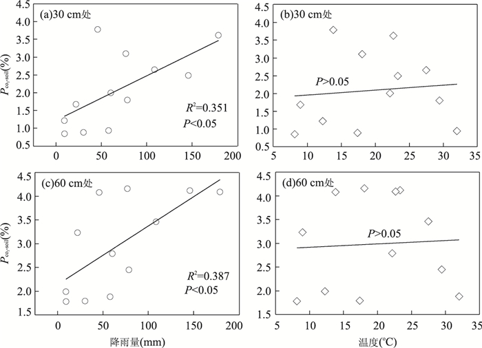
Abstract:
The high CO2 concentration in Xueyue cave, Chongqing, is rare at home and abroad. However, the circulation characteristics of carbon and its controlling factors in this cave system remain unknown. PCO2-soil, PCO2-cave, PCO2-eq, SIc, and δ13CDIC of subterranean stream were analyzed to investigate the laws of CO2 concentration variations in Xueyu cave and its contolling factors, as well as the impact on carbon cycle in this cave by subterranean stream. It is found that soil PCO2 mainly controlled by precipitation in subtropical areas was higher in rainy season than that of dry season. Cave air PCO2 exhibited seasonal variations, high cave air PCO2 typically occurred during warm periods, and low cave air PCO2 were typical of cold periods. It was ventilation driven by the temperature difference between cave and outside air that resulted in a sharp transition of cave air PCO2. Meanwhile, cave air PCO2 could rise to high level in a short period of time because of CO2 degassing from subterranean stream. Due to soil CO2 effect, groundwater became more mineralized water with low SIc and high water PCO2-eq, and dissolution in some months in rainy season. With the reduction of soil CO2 and precipitation, groundwater had low degree of mineralization with high SIc and low water PCO2-eq in dry season.
The high CO2 concentration in Xueyue cave, Chongqing, is rare at home and abroad. However, the circulation characteristics of carbon and its controlling factors in this cave system remain unknown. PCO2-soil, PCO2-cave, PCO2-eq, SIc, and δ13CDIC of subterranean stream were analyzed to investigate the laws of CO2 concentration variations in Xueyu cave and its contolling factors, as well as the impact on carbon cycle in this cave by subterranean stream. It is found that soil PCO2 mainly controlled by precipitation in subtropical areas was higher in rainy season than that of dry season. Cave air PCO2 exhibited seasonal variations, high cave air PCO2 typically occurred during warm periods, and low cave air PCO2 were typical of cold periods. It was ventilation driven by the temperature difference between cave and outside air that resulted in a sharp transition of cave air PCO2. Meanwhile, cave air PCO2 could rise to high level in a short period of time because of CO2 degassing from subterranean stream. Due to soil CO2 effect, groundwater became more mineralized water with low SIc and high water PCO2-eq, and dissolution in some months in rainy season. With the reduction of soil CO2 and precipitation, groundwater had low degree of mineralization with high SIc and low water PCO2-eq in dry season.