2017 Vol. 42, No. 10
Display Method:
 PDF 258KB
2017, 42(10): 1647-1657.
doi: 10.3799/dqkx.2017.557
Abstract:
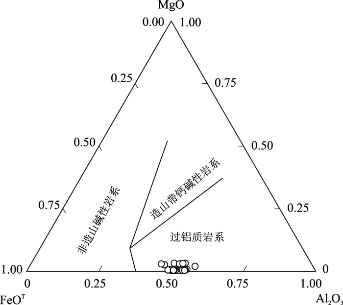
Chemical composition of biotite is always used to reveal source characteristics, tectonic environment, late hydrothermal process and enrichment of ore-forming elements. The Xitian tin-tungsten polymetallic deposit is one of the most important polygenetic compound deposits in South China. This study presents detailed mineral composition of biotites and feldspars from Xitian granite, which is closely related to the formation of the deposit. Electron microprobe analyzer (EMPA) analysis indicates that the biotites have low MgO (0.12%-1.35%) and high FeOT (15.47%-23.24%) contents with Fe/(Fe+Mg) ratios of 0.87 to 0.99, resembling to those of siderophyllite. These features indicate that their host rocks were mainly derived from partial melting of crustal materials. Estimation results of crystallization temperatures and oxygen fugacity suggest that the Xitian granite has high crystallization temperatures and low oxygen fugacities. Therefore, it is proposed that hydrothermal fluids during the late stage of magmatic evolution are favour of Sn enrichment. These hydrothermal fluids could be an important source of ore-forming fluids. High iron indexes and crystallization temperatures and low oxygen fugacities in the ore-forming system are favorable for mineralization of Xitian tin-tungsten deposit.
Chemical composition of biotite is always used to reveal source characteristics, tectonic environment, late hydrothermal process and enrichment of ore-forming elements. The Xitian tin-tungsten polymetallic deposit is one of the most important polygenetic compound deposits in South China. This study presents detailed mineral composition of biotites and feldspars from Xitian granite, which is closely related to the formation of the deposit. Electron microprobe analyzer (EMPA) analysis indicates that the biotites have low MgO (0.12%-1.35%) and high FeOT (15.47%-23.24%) contents with Fe/(Fe+Mg) ratios of 0.87 to 0.99, resembling to those of siderophyllite. These features indicate that their host rocks were mainly derived from partial melting of crustal materials. Estimation results of crystallization temperatures and oxygen fugacity suggest that the Xitian granite has high crystallization temperatures and low oxygen fugacities. Therefore, it is proposed that hydrothermal fluids during the late stage of magmatic evolution are favour of Sn enrichment. These hydrothermal fluids could be an important source of ore-forming fluids. High iron indexes and crystallization temperatures and low oxygen fugacities in the ore-forming system are favorable for mineralization of Xitian tin-tungsten deposit.


2017, 42(10): 1658-1672.
doi: 10.3799/dqkx.2017.553
Abstract:
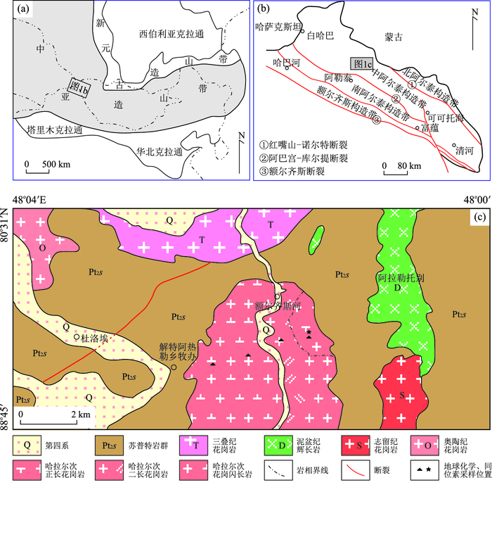
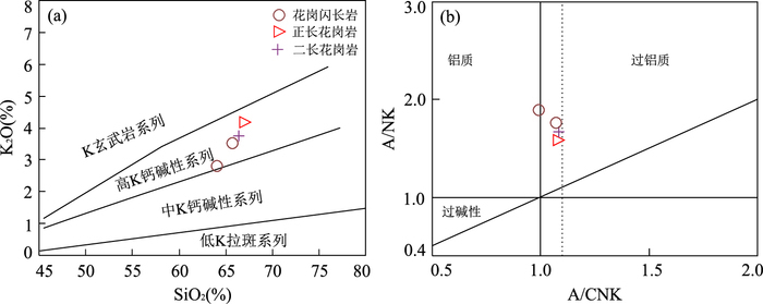
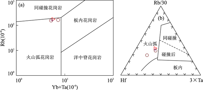
In order to study the chronological, geochemical characteristics and tectonic setting of the Halaerci granite from Altay area, the LA-MC-ICPMS zircons U-Pb dating method was employed to assess the ages and Nd isotope composition, preceded by their petrologcial and geochemical studies. In addition, the authors aim to provide more evidences for the structural evolution of Altay tectonic belt by making a comparison with other granites from central Altay orogenic belt. The exposed Halaerci granites of central Altay tectonic belt are dominated by granodiorite, monzonite and syenogranite. LA-ICP-MS zircon U-Pb chronology study suggests that formation age is from 454.8±2.4 Ma (MSWD=0.32), which belongs to the Late Ordovician magma activity. The study of geochemistry indicates that rock is characterized by high silicon, enriched alkali and high potassium (K2O/Na2O > 1) and low titanium, low magnesium and low phosphorus. Average (A/CNK) is 1.5 and corundum molecular content of CIPW calculation is greater than 1, which shows a high potassium calc-alkaline peraluminous granite characteristics. The granites are relatively enriched in light rare earth elements, while flat in heavy rare earth elements, with significant Eu negative anomaly, enrichment of Th and Rb, depletion of Sr, Ti and P elements, pronounced Nb, Ta and Ti negative anomalies, which shows the initial arc characteristic of magmatic rocks. Its εNd(t) is close to 0 (-2.0 to 0.5) and old two-phase model (TDM2) age (1.15 to 1.35) Ga indicate its source area contains more crust-derived source components with a certain amount mantle source materials. Comprehensive analysis and study suggest that Halaerci granites may be composed of partial melting of argillaceous sandstone enriched with muscovite and biotite under low pressure and high temperature. Its source area has residual plagioclase, ilmenite and apatite and mixed with mantle source materials at the same time. It is concluded that Halaerci granites formed in the active continental margin squeezing environment when the heat by local extentional stress reduction and abnormal uneven mantle materials rise led to partial melting of upper crust to mix with mantle source materials.
In order to study the chronological, geochemical characteristics and tectonic setting of the Halaerci granite from Altay area, the LA-MC-ICPMS zircons U-Pb dating method was employed to assess the ages and Nd isotope composition, preceded by their petrologcial and geochemical studies. In addition, the authors aim to provide more evidences for the structural evolution of Altay tectonic belt by making a comparison with other granites from central Altay orogenic belt. The exposed Halaerci granites of central Altay tectonic belt are dominated by granodiorite, monzonite and syenogranite. LA-ICP-MS zircon U-Pb chronology study suggests that formation age is from 454.8±2.4 Ma (MSWD=0.32), which belongs to the Late Ordovician magma activity. The study of geochemistry indicates that rock is characterized by high silicon, enriched alkali and high potassium (K2O/Na2O > 1) and low titanium, low magnesium and low phosphorus. Average (A/CNK) is 1.5 and corundum molecular content of CIPW calculation is greater than 1, which shows a high potassium calc-alkaline peraluminous granite characteristics. The granites are relatively enriched in light rare earth elements, while flat in heavy rare earth elements, with significant Eu negative anomaly, enrichment of Th and Rb, depletion of Sr, Ti and P elements, pronounced Nb, Ta and Ti negative anomalies, which shows the initial arc characteristic of magmatic rocks. Its εNd(t) is close to 0 (-2.0 to 0.5) and old two-phase model (TDM2) age (1.15 to 1.35) Ga indicate its source area contains more crust-derived source components with a certain amount mantle source materials. Comprehensive analysis and study suggest that Halaerci granites may be composed of partial melting of argillaceous sandstone enriched with muscovite and biotite under low pressure and high temperature. Its source area has residual plagioclase, ilmenite and apatite and mixed with mantle source materials at the same time. It is concluded that Halaerci granites formed in the active continental margin squeezing environment when the heat by local extentional stress reduction and abnormal uneven mantle materials rise led to partial melting of upper crust to mix with mantle source materials.


2017, 42(10): 1673-1683.
doi: 10.3799/dqkx.2017.113
Abstract:
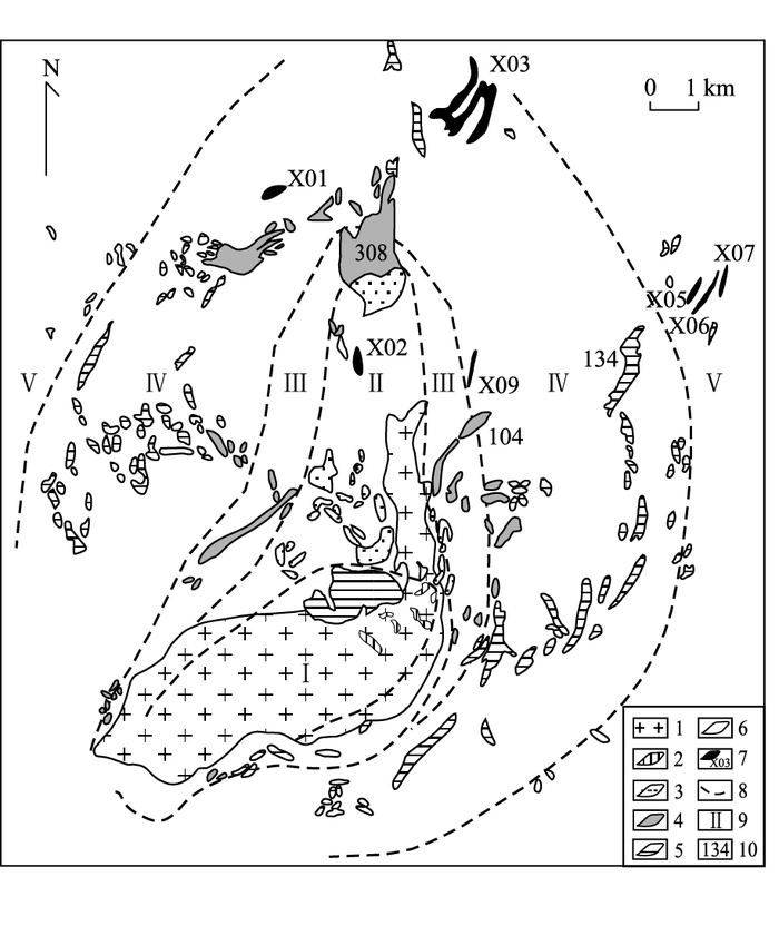
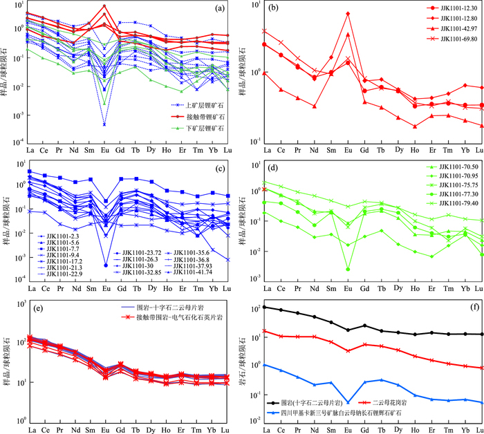
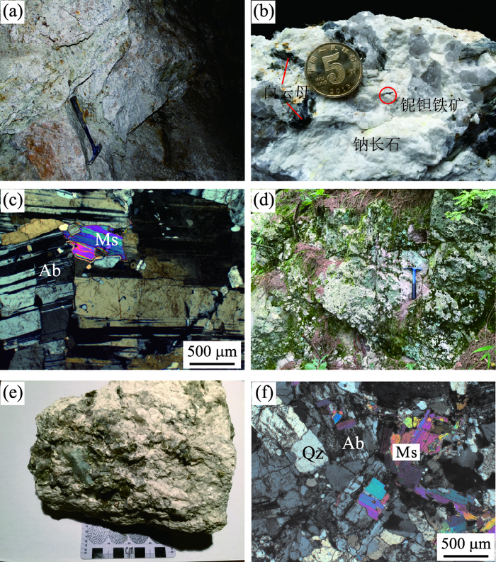
The super-large new No.3 (X03) lithium ore vein is a lithium mineralized pegmatite vein of great value. This paper summarizes the rare earth element (REE) geochemical characteristics by studying the typical drill ZK1101. Results show that the X03 lithium-mineralized pegmatite vein has a very low total amount of rare earth elements (∑REE =0.180×10⁻⁶~8.613×10⁻⁶, average=2.543×10⁻⁶, n=24), the distribution curve is right-inclined type, which means the samples are enriched in LREE and depleted in HREE, and the pegmatite shows negative anomalies of Eu. The host rocks have general REE content (∑REE=160.134×10⁻⁶~265.881×10⁻⁶, average=230.718×10⁻⁶, n=20). The rare earth distribution curve is generally inclined to the right, showing the enrichment of LREE and negative anomalies of Eu. The distribution of Eu in rare earth elements is specific, and Eu has a strong positive anomaly at the edge of the pegmatite vein. ∑REE is negatively correlated with Li, δCe and Li show a slight positive correlation, revealing the inverse correlation between rare earth element and lithium. It also means that the low content of REE is an important prospecting sign for rare metals mineralized pegmatites.
The super-large new No.3 (X03) lithium ore vein is a lithium mineralized pegmatite vein of great value. This paper summarizes the rare earth element (REE) geochemical characteristics by studying the typical drill ZK1101. Results show that the X03 lithium-mineralized pegmatite vein has a very low total amount of rare earth elements (∑REE =0.180×10⁻⁶~8.613×10⁻⁶, average=2.543×10⁻⁶, n=24), the distribution curve is right-inclined type, which means the samples are enriched in LREE and depleted in HREE, and the pegmatite shows negative anomalies of Eu. The host rocks have general REE content (∑REE=160.134×10⁻⁶~265.881×10⁻⁶, average=230.718×10⁻⁶, n=20). The rare earth distribution curve is generally inclined to the right, showing the enrichment of LREE and negative anomalies of Eu. The distribution of Eu in rare earth elements is specific, and Eu has a strong positive anomaly at the edge of the pegmatite vein. ∑REE is negatively correlated with Li, δCe and Li show a slight positive correlation, revealing the inverse correlation between rare earth element and lithium. It also means that the low content of REE is an important prospecting sign for rare metals mineralized pegmatites.


2017, 42(10): 1684-1696.
doi: 10.3799/dqkx.2017.114
Abstract:
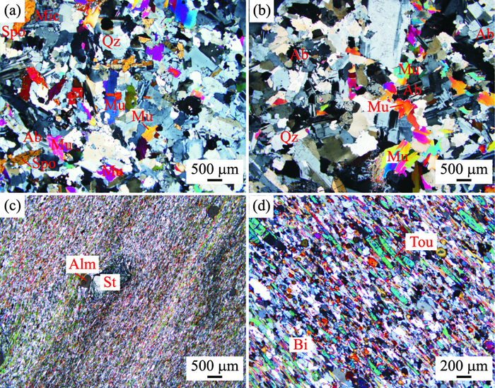
The differentiation process of granitic magma is an important factor constraining the metallogenic mechanism of rare metal. The superimposition of multistage magmatic activities in orogenic process could easily lead to the accumulation of metallogenic pegmatite melts. Mufushan composite granite mass, which is composed of multistage granite intrusions, formed an important rare metal ore concentration area in South China. In this paper we report muscovite 40Ar/39Ar dating results from tantalite-bearing muscovite albite pegmatite of Duanfengshan on the margin of granite mass, and beryl-bearing muscovite albite pegmatite of Daxing in its central region. The 40Ar/39Ar ages of muscovite are 127.7±0.9 Ma and 130.5±0.9 Ma. Based on the detailed field work and existing regional isotope chronological data, it is suggested that this area experienced long-lasting multistage magmatic evolution from early to middle Yanshanian. Rare metal mineralization of pegmatite occurred at the end of magmatic activities in Cretaceous, which showed the process of gradual enrichment and mineralization of rare metal led by regional multistage magmatic differentiation and evolution. These geological phenomena showed that Mufushan area has undergone a widely distributed continental collision orogeny in Indosinian and its tectonic setting shifted from continental collision to extensional thinning at Yanshanian. The multistage magmatic activities associated with regional lower crustal melting, which caused by underplating of basaltic magma during the process of lithospheric extension, led to the final rare metal mineralization.
The differentiation process of granitic magma is an important factor constraining the metallogenic mechanism of rare metal. The superimposition of multistage magmatic activities in orogenic process could easily lead to the accumulation of metallogenic pegmatite melts. Mufushan composite granite mass, which is composed of multistage granite intrusions, formed an important rare metal ore concentration area in South China. In this paper we report muscovite 40Ar/39Ar dating results from tantalite-bearing muscovite albite pegmatite of Duanfengshan on the margin of granite mass, and beryl-bearing muscovite albite pegmatite of Daxing in its central region. The 40Ar/39Ar ages of muscovite are 127.7±0.9 Ma and 130.5±0.9 Ma. Based on the detailed field work and existing regional isotope chronological data, it is suggested that this area experienced long-lasting multistage magmatic evolution from early to middle Yanshanian. Rare metal mineralization of pegmatite occurred at the end of magmatic activities in Cretaceous, which showed the process of gradual enrichment and mineralization of rare metal led by regional multistage magmatic differentiation and evolution. These geological phenomena showed that Mufushan area has undergone a widely distributed continental collision orogeny in Indosinian and its tectonic setting shifted from continental collision to extensional thinning at Yanshanian. The multistage magmatic activities associated with regional lower crustal melting, which caused by underplating of basaltic magma during the process of lithospheric extension, led to the final rare metal mineralization.


2017, 42(10): 1697-1706.
doi: 10.3799/dqkx.2017.115
Abstract:
X-ray diffraction (XRD), major and rare earth elements (REEs) geochemical characteristics of samples in a weathering profile from Guangxi were studied in order to reveal the geochemical behaviors of REEs during weathering. The profile can be divided into four layers from surface downwards: the humic layer (A1), the sub-clay layer(A2), the net-veined weathered layer (B1), and the completely weathered layer (B2). Clay minerals and chemical indexes of alteration (CIA) rapidly decrease from top to bottom. Samples from A1, A2 and B1 are enriched in Ce, Nd and heavy REE relative to their parent rocks. All samples are depleted in ion-exchangeable heavy REE and are relatively enriched in Y. Ion-exchangeable light and heavy REEs are enriched in the completely weathered layer. The ion-exchangeable REEs in the weathered granite are sourced mainly from labile REE-bearing minerals, such as allanite and titanate. The enrichment of heavy REE in samples from A1, A2 and B1 may have been caused by the residual zircon and xenotime, or the formation of supergene mineral, such as churchite-Y. The degree of weathering of granite leads to the change of the fractional degree of ion-exchangeable light and heavy REE.
X-ray diffraction (XRD), major and rare earth elements (REEs) geochemical characteristics of samples in a weathering profile from Guangxi were studied in order to reveal the geochemical behaviors of REEs during weathering. The profile can be divided into four layers from surface downwards: the humic layer (A1), the sub-clay layer(A2), the net-veined weathered layer (B1), and the completely weathered layer (B2). Clay minerals and chemical indexes of alteration (CIA) rapidly decrease from top to bottom. Samples from A1, A2 and B1 are enriched in Ce, Nd and heavy REE relative to their parent rocks. All samples are depleted in ion-exchangeable heavy REE and are relatively enriched in Y. Ion-exchangeable light and heavy REEs are enriched in the completely weathered layer. The ion-exchangeable REEs in the weathered granite are sourced mainly from labile REE-bearing minerals, such as allanite and titanate. The enrichment of heavy REE in samples from A1, A2 and B1 may have been caused by the residual zircon and xenotime, or the formation of supergene mineral, such as churchite-Y. The degree of weathering of granite leads to the change of the fractional degree of ion-exchangeable light and heavy REE.


2017, 42(10): 1707-1714.
doi: 10.3799/dqkx.2017.524
Abstract:
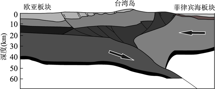
Taiwan Strait and its adjacent regions are located in the tectonic interaction front of Eurasia plate and Philippine Sea plate, they have alternately or jointly undergone extrusion, shearing and stretching tectonic processes. The isostatic adjustment has a profound effect on the tectonic evolution of Taiwan region under the complex stress environment. In this paper, we calculated the lithosphere effective elastic thickness (Te) of Taiwan Strait and its adjacent regions by isostatic response function method, and eliminated the sediment effect by stripping method, then we attained the effective thickness changes along the profile across Taiwan Strait. The effective thickness changes and its tectonic significance were analyzed, combining inversion results of Moho depth and Curie depth. The results show that the lithosphere effective elastic thickness of Taiwan Strait and its adjacent regions range from 22 to 8 km. The continental lithosphere in eastern China shows thinning trend eastward by decreasing effective elastic thickness from west to east. The effective elastic thickness increasing eastward under Taiwan Island is likely to be associated with obduction extrusion of Philippine plate. A high correlation between effective elastic thickness and Curie depth reflects Te is controlled by lithosphere temperature structure.
Taiwan Strait and its adjacent regions are located in the tectonic interaction front of Eurasia plate and Philippine Sea plate, they have alternately or jointly undergone extrusion, shearing and stretching tectonic processes. The isostatic adjustment has a profound effect on the tectonic evolution of Taiwan region under the complex stress environment. In this paper, we calculated the lithosphere effective elastic thickness (Te) of Taiwan Strait and its adjacent regions by isostatic response function method, and eliminated the sediment effect by stripping method, then we attained the effective thickness changes along the profile across Taiwan Strait. The effective thickness changes and its tectonic significance were analyzed, combining inversion results of Moho depth and Curie depth. The results show that the lithosphere effective elastic thickness of Taiwan Strait and its adjacent regions range from 22 to 8 km. The continental lithosphere in eastern China shows thinning trend eastward by decreasing effective elastic thickness from west to east. The effective elastic thickness increasing eastward under Taiwan Island is likely to be associated with obduction extrusion of Philippine plate. A high correlation between effective elastic thickness and Curie depth reflects Te is controlled by lithosphere temperature structure.


2017, 42(10): 1715-1724.
doi: 10.3799/dqkx.2017.544
Abstract:
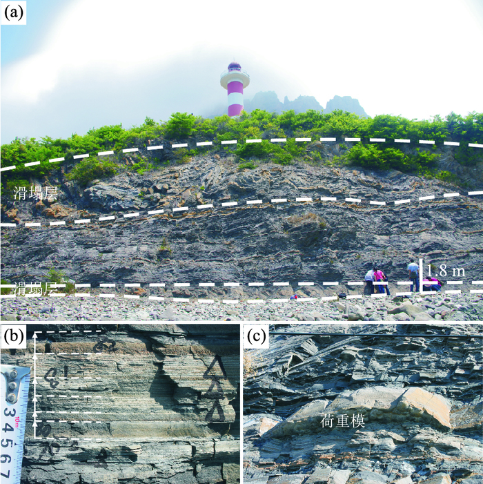
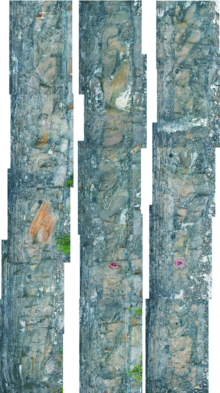
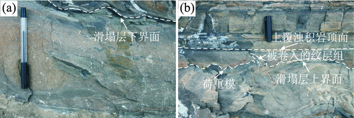
The origins of the soft-sediment deformation structures outcropped in Lingshan Island are diverse, and that the trigger of the deformation structures in the lowermost part of the Dengta section is in dispute. This contribution studied the forming processes, trigger agents and geological significance of the slump and the included structures combining yield observation and stereographic projection methods. The results show that Dengta section mainly consists of turbidite sequence. The deformed horizon is sandwiched between undeformed layers and triggered by earthquake. 4 decollement surfaces occurred internally, dividing the slump into 5 units which were different from each other in shortening and deformation degree. The main type of soft-sediment deformation is fold which display thickened fold hinge in sandstone, and layer thickening and thinning occur occasionally, both are deformations of liquefied sand under the action of driving forces. The folded sand layer and mud layer became isolated from pore-fluid communication with the sea-floor during slumping, in consequence they became temporarily overpressured, allowing the liquefaction of sand to take place. The fold axes are mainly oriented SSW-NNE, and the axial planes mainly dip to SEE (120°), both indicating the flows coming mainly from SEE. This result is consistent with the regional paleocurrent measurements from the sole marks in turbidites. Therefore, the folds in slump that develop in the subaqueous slope system have significance in indicating paleocurrent direction.
The origins of the soft-sediment deformation structures outcropped in Lingshan Island are diverse, and that the trigger of the deformation structures in the lowermost part of the Dengta section is in dispute. This contribution studied the forming processes, trigger agents and geological significance of the slump and the included structures combining yield observation and stereographic projection methods. The results show that Dengta section mainly consists of turbidite sequence. The deformed horizon is sandwiched between undeformed layers and triggered by earthquake. 4 decollement surfaces occurred internally, dividing the slump into 5 units which were different from each other in shortening and deformation degree. The main type of soft-sediment deformation is fold which display thickened fold hinge in sandstone, and layer thickening and thinning occur occasionally, both are deformations of liquefied sand under the action of driving forces. The folded sand layer and mud layer became isolated from pore-fluid communication with the sea-floor during slumping, in consequence they became temporarily overpressured, allowing the liquefaction of sand to take place. The fold axes are mainly oriented SSW-NNE, and the axial planes mainly dip to SEE (120°), both indicating the flows coming mainly from SEE. This result is consistent with the regional paleocurrent measurements from the sole marks in turbidites. Therefore, the folds in slump that develop in the subaqueous slope system have significance in indicating paleocurrent direction.


2017, 42(10): 1725-1735.
doi: 10.3799/dqkx.2017.554
Abstract:
The study on the palynology from the Yaojia Formation can provide palynology data and lay the basis on Late Cretaceous stratigraphic classification and correlation in the northeastern area of Kailu basin. Abundant sporopollen fossils of 88 species from 73 genera were recognized from the interval of 315 to 447 m of well QIV-48-61 in the Qianjiadian depression, Kailu basin in this study. Three sporopollen assemblages are established, namely the Schizaeoisporites-Cyathidites-Tricolpopollenites assemblage, the Schizaeoisporites-Classopollis-Taxodiaceaepollenites assemblage and the Schizaeoisporites-Exesipollenties-Tricolpopollenites assemblage. According to the geological range of some important elements and the correlation with relevant assemblages of other areas, the geological era of these sporopollen assemblages is assigned to the Late Cretaceous, which is equal to the Late Coniacian-Early Santonian Stage. Based on ecological characteristics, climate and humidity condition for the vegetation type of the sporopollen from the Qianjiadian area, 3 phases of paleovegetation and paleoclimate are reconstructed as follows. (1) It was humid/semi-humid tropic-subtropic climate during the interval of 405.9 to 413.2 m, presenting a vegetation landscape of coniferous forest and grass. (2) The vegetation type during the interval of 389.7 to 405.9 m was characterized by the dominance of coniferous forest, and the climate turned hot and dry, marked by the increase in the drought-tolerant taxa, corresponding to semi-arid tropic-subtropic climate. (3) Similar to the first phase, the vegetation type during the interval of 336.0 to 389.7 m was also coniferous forest including grass, which belonged to semi-humid and semi-arid tropic-subtropic climate.
The study on the palynology from the Yaojia Formation can provide palynology data and lay the basis on Late Cretaceous stratigraphic classification and correlation in the northeastern area of Kailu basin. Abundant sporopollen fossils of 88 species from 73 genera were recognized from the interval of 315 to 447 m of well QIV-48-61 in the Qianjiadian depression, Kailu basin in this study. Three sporopollen assemblages are established, namely the Schizaeoisporites-Cyathidites-Tricolpopollenites assemblage, the Schizaeoisporites-Classopollis-Taxodiaceaepollenites assemblage and the Schizaeoisporites-Exesipollenties-Tricolpopollenites assemblage. According to the geological range of some important elements and the correlation with relevant assemblages of other areas, the geological era of these sporopollen assemblages is assigned to the Late Cretaceous, which is equal to the Late Coniacian-Early Santonian Stage. Based on ecological characteristics, climate and humidity condition for the vegetation type of the sporopollen from the Qianjiadian area, 3 phases of paleovegetation and paleoclimate are reconstructed as follows. (1) It was humid/semi-humid tropic-subtropic climate during the interval of 405.9 to 413.2 m, presenting a vegetation landscape of coniferous forest and grass. (2) The vegetation type during the interval of 389.7 to 405.9 m was characterized by the dominance of coniferous forest, and the climate turned hot and dry, marked by the increase in the drought-tolerant taxa, corresponding to semi-arid tropic-subtropic climate. (3) Similar to the first phase, the vegetation type during the interval of 336.0 to 389.7 m was also coniferous forest including grass, which belonged to semi-humid and semi-arid tropic-subtropic climate.


2017, 42(10): 1736-1749.
doi: 10.3799/dqkx.2017.559
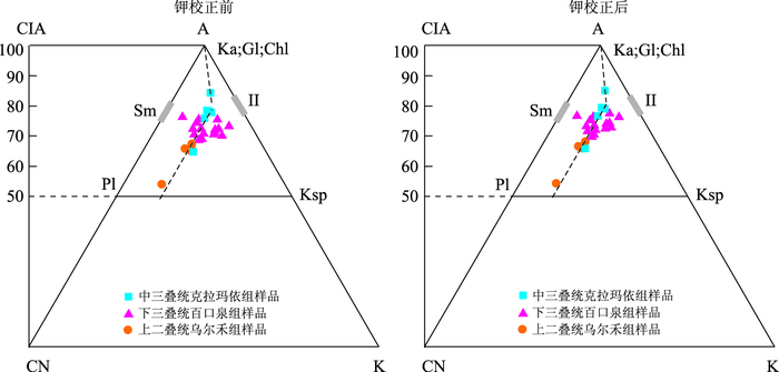
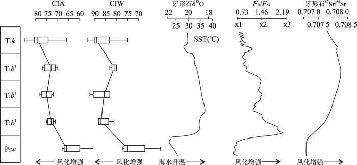
Abstract:
A series of distinct biological and environmental events have occurred during the Permian-Triassic transitional period, which are mainly indicated by marine geological record. However, little study has been done on palaeoclimate and palaeoweathering on land in Early Triassic. In order to reconstruct the palaeoclimatological information, provenance and tectonic setting from Late Permian to Middle Triassic in Mahu sag, Junggar basin, bulk-rock major and trace elemental analyses were carried out on the core mudstone samples. Palaeoweathering condition and palaeoclimatology were reconstructed through various chemical weathering indices, while the provenance and tectonic setting were inferred from various discrimination diagrams. The chemical weathering switched from lower level to middle level from Late Permian to Early Triassic, and remained steady during the Early Triassic with minor weakened trend in the late Early Triassic, indicated by the CIA (Chemical Index of Alteration), CIW (Chemical Index of Weathering), WIP (Weathering Index of Parker) and PIA (Plagioclase Index of Alteration), which agrees with the global weathering evolutionary trend shown by Sr isotopes. The palaeoclimatology from Early to Middle Triassic was warm and wet seasonally, in comparison with the cool and dry environments during the Late Permian. However, the chemical weathering of Middle Triassic in Mahu sag did not weaken simultaneously with the global trend, but increased slightly, which might be a local event. In addition, the provenance of the Upper Permian Wuerhe Formation, Early Triassic Baikouquan Formation and Middle Triassic Kelamayi Formation should be felsic igneous rocks, and the tectonic setting during the formation of source rocks probably was the oceanic island arc setting.
A series of distinct biological and environmental events have occurred during the Permian-Triassic transitional period, which are mainly indicated by marine geological record. However, little study has been done on palaeoclimate and palaeoweathering on land in Early Triassic. In order to reconstruct the palaeoclimatological information, provenance and tectonic setting from Late Permian to Middle Triassic in Mahu sag, Junggar basin, bulk-rock major and trace elemental analyses were carried out on the core mudstone samples. Palaeoweathering condition and palaeoclimatology were reconstructed through various chemical weathering indices, while the provenance and tectonic setting were inferred from various discrimination diagrams. The chemical weathering switched from lower level to middle level from Late Permian to Early Triassic, and remained steady during the Early Triassic with minor weakened trend in the late Early Triassic, indicated by the CIA (Chemical Index of Alteration), CIW (Chemical Index of Weathering), WIP (Weathering Index of Parker) and PIA (Plagioclase Index of Alteration), which agrees with the global weathering evolutionary trend shown by Sr isotopes. The palaeoclimatology from Early to Middle Triassic was warm and wet seasonally, in comparison with the cool and dry environments during the Late Permian. However, the chemical weathering of Middle Triassic in Mahu sag did not weaken simultaneously with the global trend, but increased slightly, which might be a local event. In addition, the provenance of the Upper Permian Wuerhe Formation, Early Triassic Baikouquan Formation and Middle Triassic Kelamayi Formation should be felsic igneous rocks, and the tectonic setting during the formation of source rocks probably was the oceanic island arc setting.


2017, 42(10): 1750-1759.
doi: 10.3799/dqkx.2017.538
Abstract:
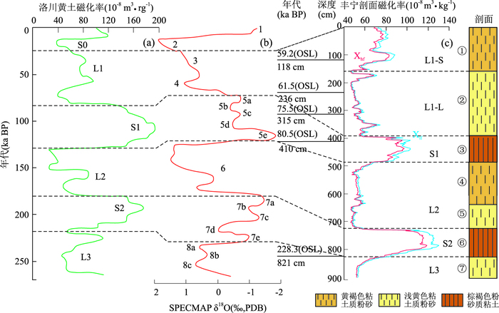
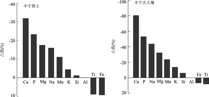
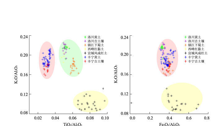
The loess deposited in the upper reaches of the Luanhe River valley is an important geological record of past palaeoclimate and palaeoenvironment in the Bashang Plateau of Hebei Province. Due to the scattered distribution and small thickness of the loess in this region, it has attracted little attention in previous studies. In order to discuss the genesis, provenance and chemical weathering intensity of loess in this region, the elemental composition analysis of 77 samples from typical loess-paleosol profile was carried out and compared with known typical aeolian deposits. The results show that: (1) The sum of major elements (SiO2, Al2O3 and Fe2O3) and UCC (Upper Continental Crust)-normalized patterns of Fengning profile are similar to those of typical aeolian deposits, indicating that Fengning loess and paleosol were aeolian; (2) Fengning loess underwent weak chemical weathering and paleosol underwent moderate chemical weathering. Compared with the typical aeolian deposits, the sequence of chemical weathering intensity is as follows: Xuancheng aeolian red earth > > Xifeng red clay and Zhenjiang Xiashu loess > Fengning paleosol and Luochuan paleosol > Luochuan loess > Fengning leoss; (3) The migration feature of major elements reveal that Fengning loess and paleosol finished the primary process of chemical weathering characterized by leaching of Ca and Na, and almost reached the secondary process characterized by leaching of K; (4) The scatter diagram of K2O/Al2O3 and Fe2O3/Al2O3 are similar to that of Luochuan loess, Luochuan paleosol, Zhenjiang Xiashu loess and Xifeng red clay, indicating that these aeolian deposits might have the same source. The ratio of TiO2/ Al2O3 is less than that of other aeolian deposits, indicating that Fengning loess and paleosol have other source.
The loess deposited in the upper reaches of the Luanhe River valley is an important geological record of past palaeoclimate and palaeoenvironment in the Bashang Plateau of Hebei Province. Due to the scattered distribution and small thickness of the loess in this region, it has attracted little attention in previous studies. In order to discuss the genesis, provenance and chemical weathering intensity of loess in this region, the elemental composition analysis of 77 samples from typical loess-paleosol profile was carried out and compared with known typical aeolian deposits. The results show that: (1) The sum of major elements (SiO2, Al2O3 and Fe2O3) and UCC (Upper Continental Crust)-normalized patterns of Fengning profile are similar to those of typical aeolian deposits, indicating that Fengning loess and paleosol were aeolian; (2) Fengning loess underwent weak chemical weathering and paleosol underwent moderate chemical weathering. Compared with the typical aeolian deposits, the sequence of chemical weathering intensity is as follows: Xuancheng aeolian red earth > > Xifeng red clay and Zhenjiang Xiashu loess > Fengning paleosol and Luochuan paleosol > Luochuan loess > Fengning leoss; (3) The migration feature of major elements reveal that Fengning loess and paleosol finished the primary process of chemical weathering characterized by leaching of Ca and Na, and almost reached the secondary process characterized by leaching of K; (4) The scatter diagram of K2O/Al2O3 and Fe2O3/Al2O3 are similar to that of Luochuan loess, Luochuan paleosol, Zhenjiang Xiashu loess and Xifeng red clay, indicating that these aeolian deposits might have the same source. The ratio of TiO2/ Al2O3 is less than that of other aeolian deposits, indicating that Fengning loess and paleosol have other source.


2017, 42(10): 1760-1773.
doi: 10.3799/dqkx.2017.569
Abstract:
There is also uncertainty about the magnetostratigraphy in the Yangtze delta. In order to establish a reliable time scale, and provide constraints for sedimentary environment and climate evolution, based on chronostratigraphy and magnetostratigraphy, in this paper astronomical time scale of the LZK1 borehole in the Yangtze delta is researched, and established the chronological framework is established. The results show that M/B, Ga/M and Gi/Ga boundaries locate at 143.0 m, 219.0 m and 296.6 m separately. The deposit cycles are clear and the sedimentary rate has obvious phases, which was influenced by the climate and sedimentary environment. The tuned frequency dependent susceptibility record reveals orbital periods including 125 ka, 96 ka, 41 ka, 23 ka, 22 ka, 18 ka, and is correlated with ETP curves enormously in orbital periods, the confidence interval exceeds 95%. The band-pass filtering curves of 100 ka, 41 ka, 23 ka circles coincide with the corresponding orbital parameter curve in phase and amplitude in total, while existing some inconformities at certain times. The inconformities may be caused by low sedimentary rate or abrupt change of sedimentary rate. In this paper, a conclusion is drawn that in the ongoing subsidence areas with temporary depositional hiatus, as long as the sampling resolution can be assured, we can establish reliable chronological framework by orbital tuning.
There is also uncertainty about the magnetostratigraphy in the Yangtze delta. In order to establish a reliable time scale, and provide constraints for sedimentary environment and climate evolution, based on chronostratigraphy and magnetostratigraphy, in this paper astronomical time scale of the LZK1 borehole in the Yangtze delta is researched, and established the chronological framework is established. The results show that M/B, Ga/M and Gi/Ga boundaries locate at 143.0 m, 219.0 m and 296.6 m separately. The deposit cycles are clear and the sedimentary rate has obvious phases, which was influenced by the climate and sedimentary environment. The tuned frequency dependent susceptibility record reveals orbital periods including 125 ka, 96 ka, 41 ka, 23 ka, 22 ka, 18 ka, and is correlated with ETP curves enormously in orbital periods, the confidence interval exceeds 95%. The band-pass filtering curves of 100 ka, 41 ka, 23 ka circles coincide with the corresponding orbital parameter curve in phase and amplitude in total, while existing some inconformities at certain times. The inconformities may be caused by low sedimentary rate or abrupt change of sedimentary rate. In this paper, a conclusion is drawn that in the ongoing subsidence areas with temporary depositional hiatus, as long as the sampling resolution can be assured, we can establish reliable chronological framework by orbital tuning.


2017, 42(10): 1774-1786.
doi: 10.3799/dqkx.2017.539
Abstract:
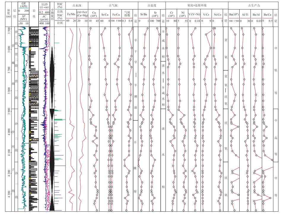
Heterogeneity study of lacustrine source rocks relys heavily on a deeper understanding of paleoenvironment and the major controlling factors on their formation. Based on element geochemical and petrological analyses of the paleoenvironment of the Early Cretaceous (from K1h to K1yc) in Changling depression., the main controlling factors of organic source rocks development were analyzed according to the characteristics of its tectonics and sedimentary and the primary productivity of the source rocks in this study. Results show that from K1h period to K1sh stage to K1yc stage, Changling depression experienced paleo-water depth change from deep to shallow, palaeoclimate from humid-semi-humid to semi-arid, palaesalinity from fresh water to brackish water, and reduction condition from enhanced to weakened. From K1sh period to K1yc, the paleoenvironment of Changling depression shows obvious zonation; The correlation between trace element indexs indicating the paleoclimate and water reduction and TOC (Total Organic Carbon) of the source rock samples is significant, while the correlation between the trace element indexs indicating the paleosalinity and TOC of the source rock samples is small. So the paleoclimatic and redox conditions are the main environmental factors of the development of Lower Cretaceous lacustrine source rocks in Changling fault depression; K1sh2 Formation high quality source rock which developed in equilibrium compensation stage, humid climate, hypoxia and high initial productivity is widely distributed. Followed by K1sh1 Formation and K1h2 Formation, the organic source rock of K1yc Formation is relatively developed in the south and east, and the distribution is relatively limited.
Heterogeneity study of lacustrine source rocks relys heavily on a deeper understanding of paleoenvironment and the major controlling factors on their formation. Based on element geochemical and petrological analyses of the paleoenvironment of the Early Cretaceous (from K1h to K1yc) in Changling depression., the main controlling factors of organic source rocks development were analyzed according to the characteristics of its tectonics and sedimentary and the primary productivity of the source rocks in this study. Results show that from K1h period to K1sh stage to K1yc stage, Changling depression experienced paleo-water depth change from deep to shallow, palaeoclimate from humid-semi-humid to semi-arid, palaesalinity from fresh water to brackish water, and reduction condition from enhanced to weakened. From K1sh period to K1yc, the paleoenvironment of Changling depression shows obvious zonation; The correlation between trace element indexs indicating the paleoclimate and water reduction and TOC (Total Organic Carbon) of the source rock samples is significant, while the correlation between the trace element indexs indicating the paleosalinity and TOC of the source rock samples is small. So the paleoclimatic and redox conditions are the main environmental factors of the development of Lower Cretaceous lacustrine source rocks in Changling fault depression; K1sh2 Formation high quality source rock which developed in equilibrium compensation stage, humid climate, hypoxia and high initial productivity is widely distributed. Followed by K1sh1 Formation and K1h2 Formation, the organic source rock of K1yc Formation is relatively developed in the south and east, and the distribution is relatively limited.


2017, 42(10): 1787-1801.
doi: 10.3799/dqkx.2017.549
Abstract:
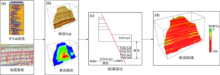
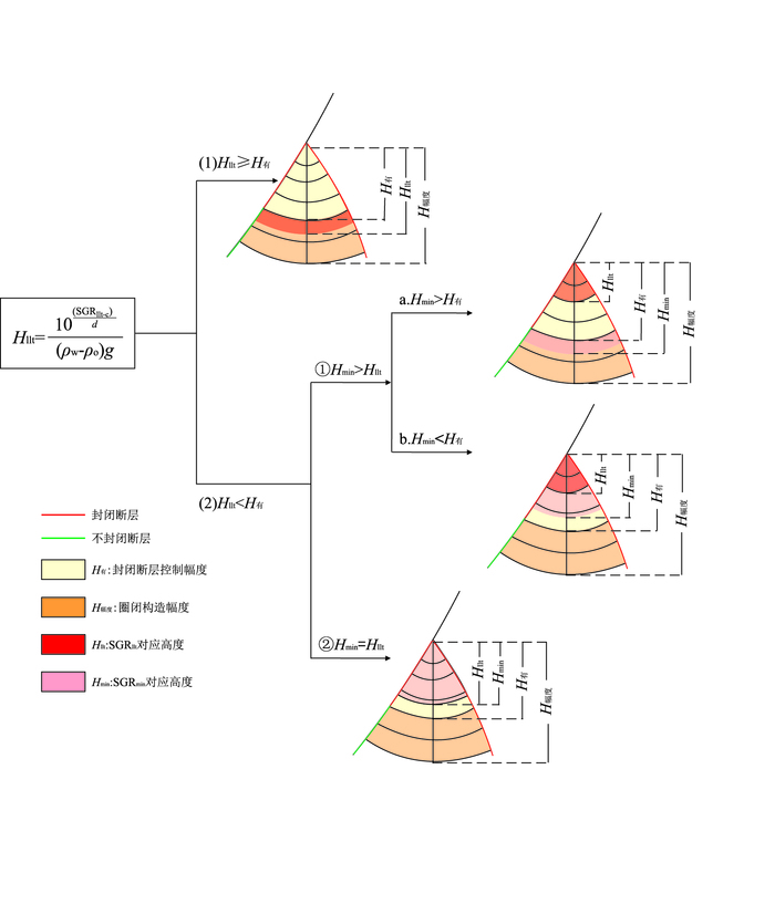
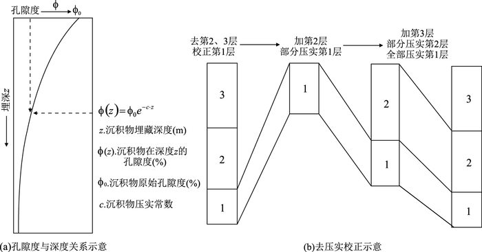
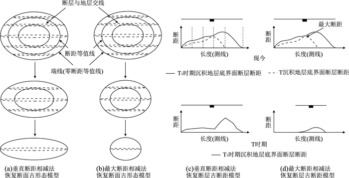
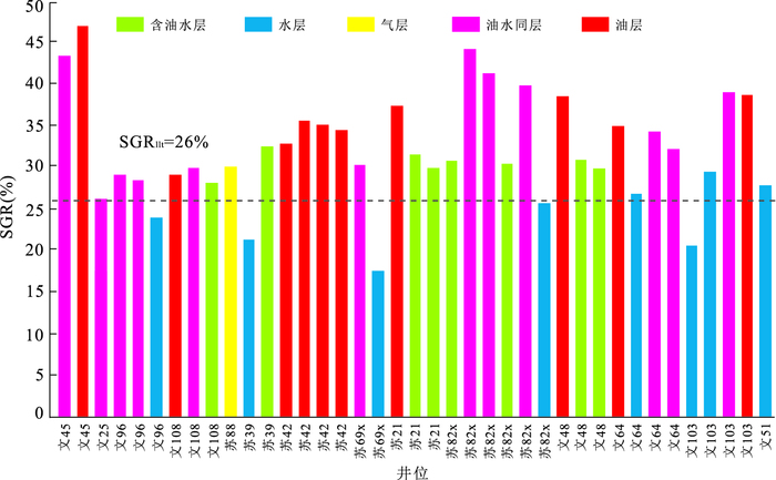
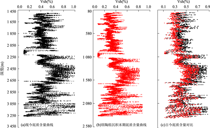
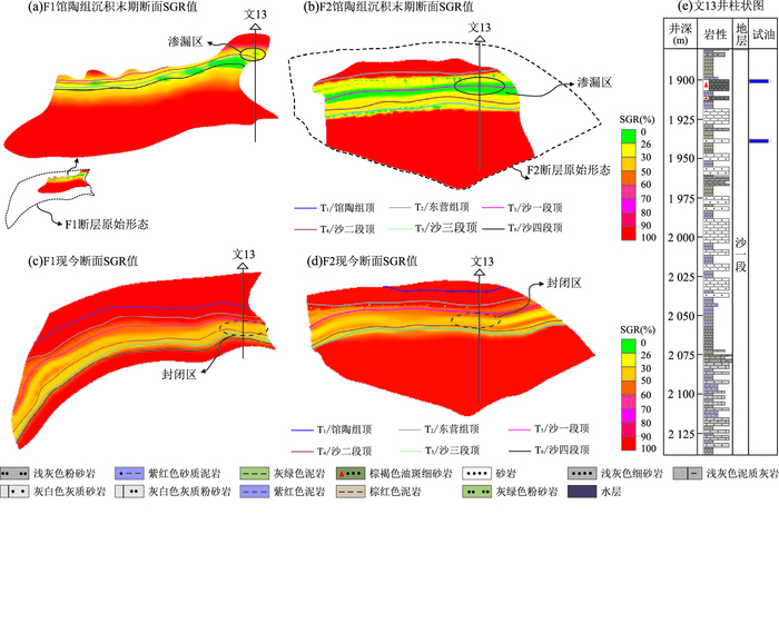
The ability of fault lateral sealing has an important influence on the accumulation and distribution of oil and gas in hydrocarbon accumulation period. However, fault sealing can only be evaluated by the method of lateral sealing of the lower limit at present. Moreover, it is found that find lateral sealing ability of fault and distribution of oil show some inconsistencies in the evaluation process in which wells located in the range of forecast turn out not contain oil and gas. It is found in this study that this phenomenon may be due to the weak ancient lateral seal ability of the fault in the hydrocarbon accumulation period. Therefore, an evaluation method of ancient lateral sealing evaluation metnd of ancient lateral sealing evaluation method of fault is proposed on the basis of the SGR (Shale Gouge Ratio) threshold method of the fault lateral seal, oil and gas, restoring the ancient strata thickness, the ancient fault throw, and the ancient shale content curve in the hydrocarbon accumulation period. This paper selects Wen13 fault trap in the Wenan slope of Jizhong depression as an example, and the fault trap lateral sealing ability is quantitatively evaluated by the ancient fault lateral sealing evaluation method. The results show that the lateral seal hydrocarbon height of the Wen13 fault trap is zero meter, in conformity with the well test results, which indicates that the evaluation method of the ancient fault lateral sealing ability is feasible. For accurate evaluation of the ability of seal hydrocarbon in the fault trap, it is of practical and theoretical significance to reduce the hydrocarbon drilling risk of fault trap, to enrich and perfect the fault lateral seal theory.
The ability of fault lateral sealing has an important influence on the accumulation and distribution of oil and gas in hydrocarbon accumulation period. However, fault sealing can only be evaluated by the method of lateral sealing of the lower limit at present. Moreover, it is found that find lateral sealing ability of fault and distribution of oil show some inconsistencies in the evaluation process in which wells located in the range of forecast turn out not contain oil and gas. It is found in this study that this phenomenon may be due to the weak ancient lateral seal ability of the fault in the hydrocarbon accumulation period. Therefore, an evaluation method of ancient lateral sealing evaluation metnd of ancient lateral sealing evaluation method of fault is proposed on the basis of the SGR (Shale Gouge Ratio) threshold method of the fault lateral seal, oil and gas, restoring the ancient strata thickness, the ancient fault throw, and the ancient shale content curve in the hydrocarbon accumulation period. This paper selects Wen13 fault trap in the Wenan slope of Jizhong depression as an example, and the fault trap lateral sealing ability is quantitatively evaluated by the ancient fault lateral sealing evaluation method. The results show that the lateral seal hydrocarbon height of the Wen13 fault trap is zero meter, in conformity with the well test results, which indicates that the evaluation method of the ancient fault lateral sealing ability is feasible. For accurate evaluation of the ability of seal hydrocarbon in the fault trap, it is of practical and theoretical significance to reduce the hydrocarbon drilling risk of fault trap, to enrich and perfect the fault lateral seal theory.


2017, 42(10): 1802-1816.
doi: 10.3799/dqkx.2017.558
Abstract:
The research of diagenesis and physical property evolution is important to tight sandstone reservoir and tight oil exploitation. The tight reservoir was detailedly studied in the study area by the analysis of cast thin section, scanning electron microscopy (SEM), X-ray diffraction and homogenization temperature analysis of fluid inclusion in this study. The results show that deep-water sand body is a typical ultra-low porosity and permeability reservoir, which has fine granularity, poor reservoir physical properties, with thin pore-micro throat dominated pore-throat combination. The reservoir in the B sub-stage of mesogenetic diagenesis has experienced the following complex diagenesis evolution sequence: compaction/calcite cementation→tuffaceous hydrolyze alteration/mica hydration/illite cementation/chlorite cementation/quartz dissolution→early feldspar dissolution/quartz overgrowth/carbonate plaster recrystallization/early carbonate-cement dissolution→late feldspar dissolution→ferroan calcite cementation. The diagenetic environment underwent an evolution of alkalescence→acid→alkalescence. The test data of fluid inclusions show that Early Cretaceous (99-118 Ma) is the main hydrocarbon accumulation period with two hydrocarbon injections. The reservoir physical properties evolution show that early diagenesis had great influence on the reservoir, and it is inferred that the sandstone had already been compacted very tight before the hydrocarbon accumulation period.
The research of diagenesis and physical property evolution is important to tight sandstone reservoir and tight oil exploitation. The tight reservoir was detailedly studied in the study area by the analysis of cast thin section, scanning electron microscopy (SEM), X-ray diffraction and homogenization temperature analysis of fluid inclusion in this study. The results show that deep-water sand body is a typical ultra-low porosity and permeability reservoir, which has fine granularity, poor reservoir physical properties, with thin pore-micro throat dominated pore-throat combination. The reservoir in the B sub-stage of mesogenetic diagenesis has experienced the following complex diagenesis evolution sequence: compaction/calcite cementation→tuffaceous hydrolyze alteration/mica hydration/illite cementation/chlorite cementation/quartz dissolution→early feldspar dissolution/quartz overgrowth/carbonate plaster recrystallization/early carbonate-cement dissolution→late feldspar dissolution→ferroan calcite cementation. The diagenetic environment underwent an evolution of alkalescence→acid→alkalescence. The test data of fluid inclusions show that Early Cretaceous (99-118 Ma) is the main hydrocarbon accumulation period with two hydrocarbon injections. The reservoir physical properties evolution show that early diagenesis had great influence on the reservoir, and it is inferred that the sandstone had already been compacted very tight before the hydrocarbon accumulation period.


2017, 42(10): 1817-1829.
doi: 10.3799/dqkx.2017.568
Abstract:
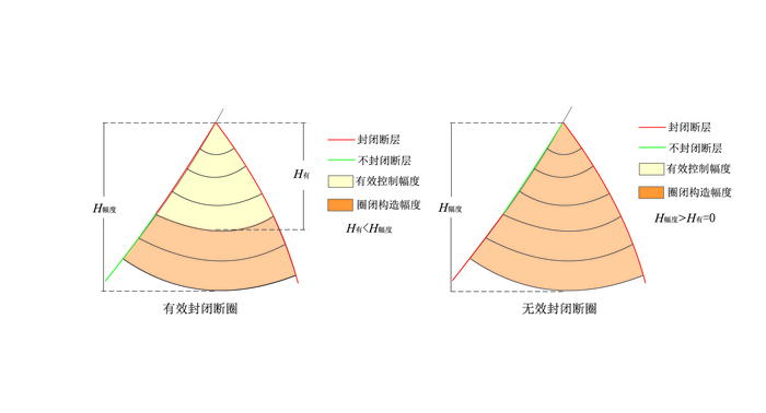
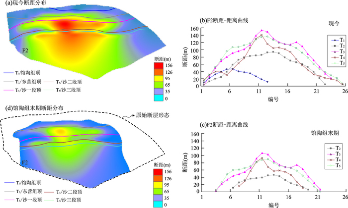
Reservoirs in Longfengshan area are characterized by "other-source, generation in lower part, storage and accumulation in the upper part". It faclitates the hydrocarbon exploration by determining the fault control to hydrocarbon migration and accumulation. Based on precise illustration of the static characteristics of faults, fault activity, sealing capacity and fault-caprock configuration are evaluated quantitatively in this study. In addition, a method of SGR (Shale Gouge Ratio) lower limit for assessing fault-caprock configuration effectiveness is proposed. Combined with hydrocarbon distribution, the controlling effect on the differential accumulation of hydrocarbon is discussed. The study shows that hydrocarbon can migrate vertically through faults on a large scale at the early and middle stages of the first accumulation period. At the end of the first and the second accumulation periods, sealing corridor space formed by two faults is the main hydrocarbon accumulation site. Application of the SGR lower limit method indicates that fault-caprock configuration of K1yc3 is good enough to provide favourable conditions for hydrocarbon conservation. Consequently, the effect of faults controlling on hydrocarbon migration and accumulation can be summarized into following three aspects. This is fault activity controls the hydrocarbon vertical migration scale in different stages; fault sealing capacity controls the horizontal enrichment degree of hydrocarbon, and fault-caprock configuration controls petroliferous reservoir.
Reservoirs in Longfengshan area are characterized by "other-source, generation in lower part, storage and accumulation in the upper part". It faclitates the hydrocarbon exploration by determining the fault control to hydrocarbon migration and accumulation. Based on precise illustration of the static characteristics of faults, fault activity, sealing capacity and fault-caprock configuration are evaluated quantitatively in this study. In addition, a method of SGR (Shale Gouge Ratio) lower limit for assessing fault-caprock configuration effectiveness is proposed. Combined with hydrocarbon distribution, the controlling effect on the differential accumulation of hydrocarbon is discussed. The study shows that hydrocarbon can migrate vertically through faults on a large scale at the early and middle stages of the first accumulation period. At the end of the first and the second accumulation periods, sealing corridor space formed by two faults is the main hydrocarbon accumulation site. Application of the SGR lower limit method indicates that fault-caprock configuration of K1yc3 is good enough to provide favourable conditions for hydrocarbon conservation. Consequently, the effect of faults controlling on hydrocarbon migration and accumulation can be summarized into following three aspects. This is fault activity controls the hydrocarbon vertical migration scale in different stages; fault sealing capacity controls the horizontal enrichment degree of hydrocarbon, and fault-caprock configuration controls petroliferous reservoir.


2017, 42(10): 1830-1841.
doi: 10.3799/dqkx.2017.555
Abstract:
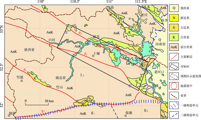
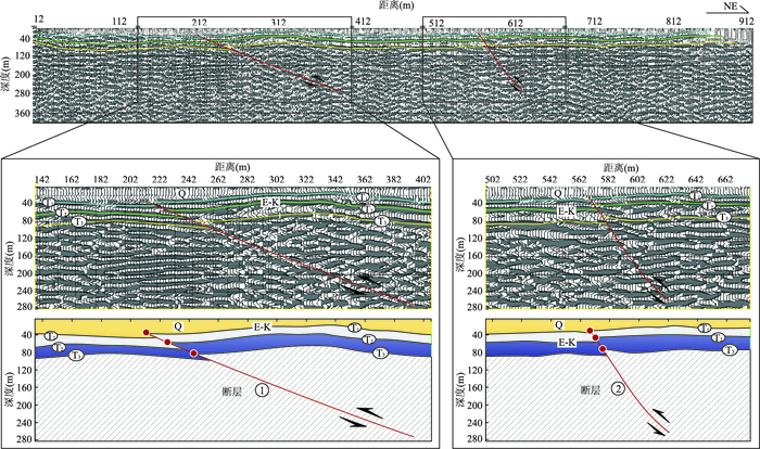
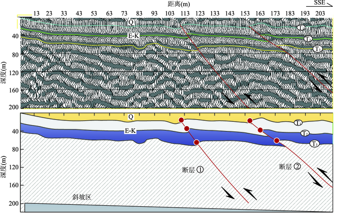
West Hubei Province is located at an important point of the continental structure in China with complex geological structure, of which the Danjiangkou reservoir area is the core area of the South-to-North Water Diversion (SNWD) Project of China. An investigation of fault structure is important for the construction of seismic safety system of the SDWN Project. In this study, a shallow seismic-reflection technology to analyze 0 to 300 m structures of Danjian, Liangyun and Baihe-Gucheng fault zones around the Danjiangkou reservoir is used. The results show that most of fault, striking in the three fault zones are roughly in NE direction. Normal faults largely exist in the Danjiangkou and the Baihe-Gucheng fault zones. In contrast, Liangyun fault zone mainly consists of reverse faults. This fault distribution may be associated with the local stress imposed by the Danjiangkou reservoir. The results not only reveal fault characteristics of the Danjiangkou region but also provide important information of relationship between the background stress in this area and its surrounding tectonic unit for the future studies in seismology.
West Hubei Province is located at an important point of the continental structure in China with complex geological structure, of which the Danjiangkou reservoir area is the core area of the South-to-North Water Diversion (SNWD) Project of China. An investigation of fault structure is important for the construction of seismic safety system of the SDWN Project. In this study, a shallow seismic-reflection technology to analyze 0 to 300 m structures of Danjian, Liangyun and Baihe-Gucheng fault zones around the Danjiangkou reservoir is used. The results show that most of fault, striking in the three fault zones are roughly in NE direction. Normal faults largely exist in the Danjiangkou and the Baihe-Gucheng fault zones. In contrast, Liangyun fault zone mainly consists of reverse faults. This fault distribution may be associated with the local stress imposed by the Danjiangkou reservoir. The results not only reveal fault characteristics of the Danjiangkou region but also provide important information of relationship between the background stress in this area and its surrounding tectonic unit for the future studies in seismology.


2017, 42(10): 1842-1850.
doi: 10.3799/dqkx.2017.116
Abstract:
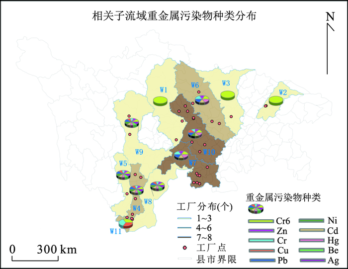
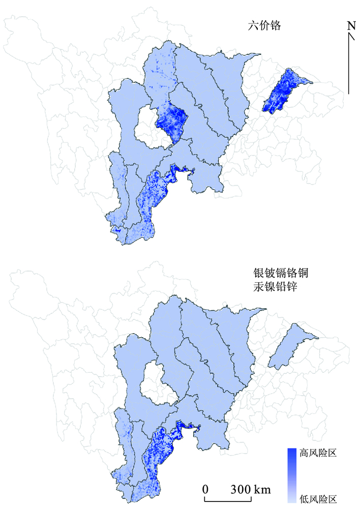
To minimize the unexpected seismic damage, it is significant to evaluate the potantial seismic risk in the high probabilisitic seismic hazard zones and take effective precautionary measures. This paper aims to evaluate the risk of heavy metal non-point source pollution caused by seismic-led industrial building collapse. It is based on the seismic hazard of 10-percent probability of exceedance in 50 years, and the minimum value of the water quality standard in Sichuan, China. The method of Soil Conservation Service (SCS) curve number (CN) was used to compute the daily runoff depth, and to estimate the potential risk state of non-point source heavy metal pollution combined with the seismic damage index and population index. The results indicate: (1) eleven sub-basins are under the potential risk of seismic-led non-point source heavy metal pollution; (2) Compared to other heavy metal pollutants, more sub-basins are under the risk of Cr6+ pollution, and are mainly distributed in the northeast, central and south central of Sichuan province, whereas high risk subbasins of other heavy metal pollutants are most located in the south central areas of Sichuan province; (3) considering the population index, the high risk areas of Cr6+ pollution are mainly in the southeast of sub-basins W1 and W2, while those subjected to pollution of other heavy metals are mostly in the north of sub-basin W4.
To minimize the unexpected seismic damage, it is significant to evaluate the potantial seismic risk in the high probabilisitic seismic hazard zones and take effective precautionary measures. This paper aims to evaluate the risk of heavy metal non-point source pollution caused by seismic-led industrial building collapse. It is based on the seismic hazard of 10-percent probability of exceedance in 50 years, and the minimum value of the water quality standard in Sichuan, China. The method of Soil Conservation Service (SCS) curve number (CN) was used to compute the daily runoff depth, and to estimate the potential risk state of non-point source heavy metal pollution combined with the seismic damage index and population index. The results indicate: (1) eleven sub-basins are under the potential risk of seismic-led non-point source heavy metal pollution; (2) Compared to other heavy metal pollutants, more sub-basins are under the risk of Cr6+ pollution, and are mainly distributed in the northeast, central and south central of Sichuan province, whereas high risk subbasins of other heavy metal pollutants are most located in the south central areas of Sichuan province; (3) considering the population index, the high risk areas of Cr6+ pollution are mainly in the southeast of sub-basins W1 and W2, while those subjected to pollution of other heavy metals are mostly in the north of sub-basin W4.