2017 Vol. 42, No. 5
Display Method:
 PDF 1725KB
2017, 42(5): 661-673.
doi: 10.3799/dqkx.2017.054
Abstract:
It is always challenging to quantify precisely the hydrologic exchange and biogeochemical reaction in hyporheic zone. The core task for the research of hydro-biogeochemistry in hyporheic zone is to associate the hydrologic flux and biogeochemical reaction dynamics on small scale, with their cumulative effect on water quality and ecology of rivers on larger scale. This paper presents the basic principles of hydrology-biogeochemistry coupling in hyporheic zone, and systematically summarizes hydrologic approaches including measurement by seepage meter, piezometer measuring, tracer injection experiment, streambed temperature profile, environmental tracer and mass balance, and biogeochemical approaches including field tracer experiment and indoor incubation experiment. In addition, this paper specifically illustrates the cumulative effect of hydrologic and biogeochemical processes in hyporheic zone for larger scale, and its ecological significance. It is suggested that the future research on hyporheic zone science shall focus on the advance of research methods, development of hydrogeomorphic theory and model, and up scaling of biogeochemical processes in hyporheic zone.
It is always challenging to quantify precisely the hydrologic exchange and biogeochemical reaction in hyporheic zone. The core task for the research of hydro-biogeochemistry in hyporheic zone is to associate the hydrologic flux and biogeochemical reaction dynamics on small scale, with their cumulative effect on water quality and ecology of rivers on larger scale. This paper presents the basic principles of hydrology-biogeochemistry coupling in hyporheic zone, and systematically summarizes hydrologic approaches including measurement by seepage meter, piezometer measuring, tracer injection experiment, streambed temperature profile, environmental tracer and mass balance, and biogeochemical approaches including field tracer experiment and indoor incubation experiment. In addition, this paper specifically illustrates the cumulative effect of hydrologic and biogeochemical processes in hyporheic zone for larger scale, and its ecological significance. It is suggested that the future research on hyporheic zone science shall focus on the advance of research methods, development of hydrogeomorphic theory and model, and up scaling of biogeochemical processes in hyporheic zone.


2017, 42(5): 674-684.
doi: 10.3799/dqkx.2017.055
Abstract:
The pollution of NO3--N and NH3-N in groundwater is very serious in the eastern of Jianghan plain, which is characterized by strong interactions between groundwater and surface water and obvious variations of seasonal hydrological condition. Sediment samples along vertical profiles of three boreholes and groundwater samples with different depths in different seasons were sampled to analyze the nitrogen speciation coupled with supporting chemistry in a typical field site. The results show that NO3--N with concentrations from 25.8 to 119.48 mg/kg is a dominant speciation of the total exchangeable nitrogen in sediments. The NH3-N concentrations have a good positive correlation with TOC and TN contents in sediments, implying NH3-N was mainly influenced by organic matter. The concentration and speciation of nitrogen in the groundwater deeper than 2 m show a significant response to the fluctuation of groundwater level. During the monsoon season, groundwater level increased, enhancing the reducing potential of aquifer media. As a result, NO3--N was not liable to be produced and was more likely to be consumed by denitrification. At the same time, with the mineralization enhanced, NH3-N was gradually becoming the main speciation of dissolved inorganic nitrogen. After the monsoon season, groundwater level declined, enhancing the oxidizing potential of aquifer media.As a result, nitrification was enhanced and denitrification was limited, and the concentration of NO3--N increased.Anthropogenic activities near the surface had a significant effect on the concentration and speciation of nitrogen in the groundwater shallower than 2 m. In summary, under the coupled influence of natural and anthropogenic factors, seasonal hydrological change resulted in the variation of redox potential, which was the main trigger for seasonal variation of nitrogen concentration and speciation in the groundwater.
The pollution of NO3--N and NH3-N in groundwater is very serious in the eastern of Jianghan plain, which is characterized by strong interactions between groundwater and surface water and obvious variations of seasonal hydrological condition. Sediment samples along vertical profiles of three boreholes and groundwater samples with different depths in different seasons were sampled to analyze the nitrogen speciation coupled with supporting chemistry in a typical field site. The results show that NO3--N with concentrations from 25.8 to 119.48 mg/kg is a dominant speciation of the total exchangeable nitrogen in sediments. The NH3-N concentrations have a good positive correlation with TOC and TN contents in sediments, implying NH3-N was mainly influenced by organic matter. The concentration and speciation of nitrogen in the groundwater deeper than 2 m show a significant response to the fluctuation of groundwater level. During the monsoon season, groundwater level increased, enhancing the reducing potential of aquifer media. As a result, NO3--N was not liable to be produced and was more likely to be consumed by denitrification. At the same time, with the mineralization enhanced, NH3-N was gradually becoming the main speciation of dissolved inorganic nitrogen. After the monsoon season, groundwater level declined, enhancing the oxidizing potential of aquifer media.As a result, nitrification was enhanced and denitrification was limited, and the concentration of NO3--N increased.Anthropogenic activities near the surface had a significant effect on the concentration and speciation of nitrogen in the groundwater shallower than 2 m. In summary, under the coupled influence of natural and anthropogenic factors, seasonal hydrological change resulted in the variation of redox potential, which was the main trigger for seasonal variation of nitrogen concentration and speciation in the groundwater.


2017, 42(5): 685-692.
doi: 10.3799/dqkx.2017.056
Abstract:
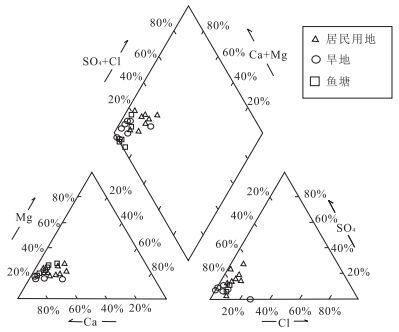
The shallow groundwater is an important water supply source in the eastern Jianghan plain, but it is confronted with pollution and inferior quality of natural water. This study identifies the chemical characteristics, control processes and influencing factors of shallow groundwater in the study area based on the results of water chemistry, hydrogen and oxygen isotope, using methods of mathematical statistics and factor analysis. Results show that the shallow groundwater chemical types are mainly HCO3-Ca, the contents of Ca2+ and Mg2+ in the phreatic water are close to those in confined water, the contents of the As, Fe, NH4+ are lower than those in confined water, but the contents of the Cl-, SO42-, Mn and NO3- are higher than those in confined water. The shallow groundwater mainly originates from precipitation and the phreatic water has experienced a degree of evaporation and the mixture of surface water. Among the influencing factors of shallow groundwater chemical characteristics, the geologic origin may play a leading role; human activities have dramatically changed the chemical characteristics of the phreatic water, and the shallow confined water is mainly affected by water-rock interaction of the runoff process.
The shallow groundwater is an important water supply source in the eastern Jianghan plain, but it is confronted with pollution and inferior quality of natural water. This study identifies the chemical characteristics, control processes and influencing factors of shallow groundwater in the study area based on the results of water chemistry, hydrogen and oxygen isotope, using methods of mathematical statistics and factor analysis. Results show that the shallow groundwater chemical types are mainly HCO3-Ca, the contents of Ca2+ and Mg2+ in the phreatic water are close to those in confined water, the contents of the As, Fe, NH4+ are lower than those in confined water, but the contents of the Cl-, SO42-, Mn and NO3- are higher than those in confined water. The shallow groundwater mainly originates from precipitation and the phreatic water has experienced a degree of evaporation and the mixture of surface water. Among the influencing factors of shallow groundwater chemical characteristics, the geologic origin may play a leading role; human activities have dramatically changed the chemical characteristics of the phreatic water, and the shallow confined water is mainly affected by water-rock interaction of the runoff process.


2017, 42(5): 693-706.
doi: 10.3799/dqkx.2017.057
Abstract:
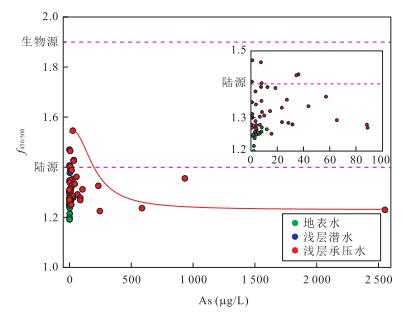
Jianghan plain has been determined as a new endemic arsenic-poisoning area in the southern China. In order to understand the role of rare earth elements (REE)on arsenic mobilization in groundwater from the Jianghan plain, REE concentrations were measured in 114 groundwater samples and 9 sediment samples from the shallow arsenic-affected aquifer system and the REE speciations along the groundwater flow path were caculated by the hydrogeochemical PHREEQC simulation. The results indicate that the REE concentrations range from 0.032 to 0.843 μg/L. The groundwater exhibite the enrichment of LREE and dramatically positive Eu anomalies, and the Eu anomalies are positively correlated with As concentration. The REE speciation mainly existes as LnCO3+ and Ln(CO3)2-, meanwhile the LnCO3+ concentrations decrease and Ln(CO3)22- concentrations increased along the regional groundwater flow path. The distribution of REE concentrations was mainly affected by the complexation with HCO3- and the reductive dissolution of iron oxide minerals. The enrichment of LREE in the groundwater was affected by the REE distribution patterns of minerals in the aquifer and the preferential desorption with LREE of iron oxide minerals, and the REE speciation was controlled by the pH along the groundwater flow path. The Eu concentrations and positive Eu anomalies could indicate the enrichment of arsenic in the groundwater.
Jianghan plain has been determined as a new endemic arsenic-poisoning area in the southern China. In order to understand the role of rare earth elements (REE)on arsenic mobilization in groundwater from the Jianghan plain, REE concentrations were measured in 114 groundwater samples and 9 sediment samples from the shallow arsenic-affected aquifer system and the REE speciations along the groundwater flow path were caculated by the hydrogeochemical PHREEQC simulation. The results indicate that the REE concentrations range from 0.032 to 0.843 μg/L. The groundwater exhibite the enrichment of LREE and dramatically positive Eu anomalies, and the Eu anomalies are positively correlated with As concentration. The REE speciation mainly existes as LnCO3+ and Ln(CO3)2-, meanwhile the LnCO3+ concentrations decrease and Ln(CO3)22- concentrations increased along the regional groundwater flow path. The distribution of REE concentrations was mainly affected by the complexation with HCO3- and the reductive dissolution of iron oxide minerals. The enrichment of LREE in the groundwater was affected by the REE distribution patterns of minerals in the aquifer and the preferential desorption with LREE of iron oxide minerals, and the REE speciation was controlled by the pH along the groundwater flow path. The Eu concentrations and positive Eu anomalies could indicate the enrichment of arsenic in the groundwater.


2017, 42(5): 707-715.
doi: 10.3799/dqkx.2017.058
Abstract:
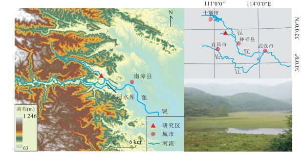
Lakes in Xiantao area are continuously shrinking, while the eutrophication level and the heavy metal contents of wetland sediments rising, relatively, the ecosystem of the lakes in Jianghan plain weakening increasingly. Enhancing the studies on the eco-environment evolution, analyzing the effects of human activities and eutrophication on lake ecosystem, and discussing the rules of carbon burials in different sedimentary environments are particularly important. Based on the Quaternary geological survey of the key regions in Jianghan plain, we collected and determined sediment samples from 16 key sites in 8 different sedimentary environments (including large fisheries, small fish ponds, vadum, lakes, paddy fields, spillway, dry fields and terrace of Hanjiang River). The total organic carbon(TOC) contents of the surface soils show that the level of organic carbon in the southern area (lake sedimentary environment) is higher than that in the northern region (fluvial and pluvial environment causes), which is consitent with human activity intensity and eutrophication level indicated by pigment, total nitrogen(TN). Carbon burials of shallow core sediments are consistent with the eutrophication level indicated by pigment showing a rising tendency. The rates of carbon burials are various in different sedimentary environments. The highest is in large fisheries (77.71 g·m-2·a-1) while the lowest is in the terrace of Hanjiang River (3.61 g·m-2·a-1). Our study indicates that the carbon aggregation function of lakes is constantly enhancing, and it has important significance to study the carbon cycle of the critical zones in Jianghan plain.
Lakes in Xiantao area are continuously shrinking, while the eutrophication level and the heavy metal contents of wetland sediments rising, relatively, the ecosystem of the lakes in Jianghan plain weakening increasingly. Enhancing the studies on the eco-environment evolution, analyzing the effects of human activities and eutrophication on lake ecosystem, and discussing the rules of carbon burials in different sedimentary environments are particularly important. Based on the Quaternary geological survey of the key regions in Jianghan plain, we collected and determined sediment samples from 16 key sites in 8 different sedimentary environments (including large fisheries, small fish ponds, vadum, lakes, paddy fields, spillway, dry fields and terrace of Hanjiang River). The total organic carbon(TOC) contents of the surface soils show that the level of organic carbon in the southern area (lake sedimentary environment) is higher than that in the northern region (fluvial and pluvial environment causes), which is consitent with human activity intensity and eutrophication level indicated by pigment, total nitrogen(TN). Carbon burials of shallow core sediments are consistent with the eutrophication level indicated by pigment showing a rising tendency. The rates of carbon burials are various in different sedimentary environments. The highest is in large fisheries (77.71 g·m-2·a-1) while the lowest is in the terrace of Hanjiang River (3.61 g·m-2·a-1). Our study indicates that the carbon aggregation function of lakes is constantly enhancing, and it has important significance to study the carbon cycle of the critical zones in Jianghan plain.


2017, 42(5): 716-726.
doi: 10.3799/dqkx.2017.059
Abstract:
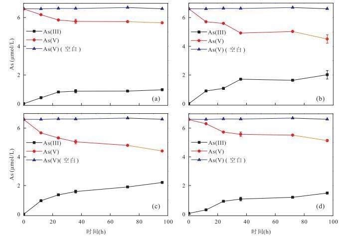
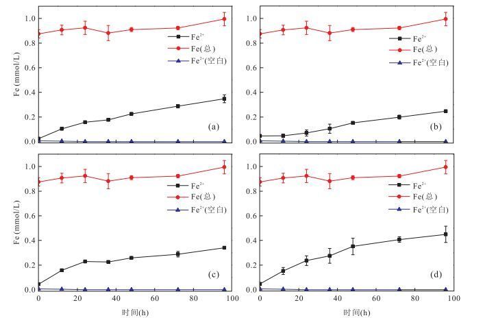
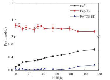
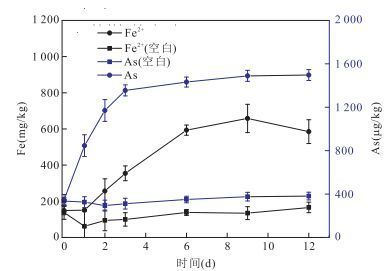
Microbial mediated iron-oxide mineral reduction and subsequent arsenic mobilization is the primary cause of arsenic-rich groundwater in south and southeastern Asia, however, the role of iron-reducing and arsenic-reducing microbes isolated from aquifer is not clearly understood. In this study, four strains, Citrobacter sp.JH-1, Clostridium sp.JH-6, Exiguobacterium sp.JH-13 and Paenibacillus sp.JH-33, were isolated from the aquifer in Jianghan plain, which is the typical arsenic-rich aquifer in central China. Each of them was used to identify their ability of arsenate (As(Ⅴ)), ferric iron (Fe(Ⅲ)) and ferrihydrite reduction by batch cultural experiment under aerobic and anaerobic condition. The results indicate that all these four strains can reduce both As(Ⅴ) and Fe(Ⅲ) under anaerobic condition. Among them, the Citrobacter sp.JH-1 possessed the strongest reducing ability for As(Ⅴ), which could reduce 2.22 μmol/L As(Ⅴ) after 96 h, and it could also reduce amorphous iron oxide minerals (ferrihydrite) under aerobic condition. After the cultivation with the sediment sample collected from in situ aquifer, Citrobacter sp.JH-1 could release 510 mg/kg iron and 1 150 μg/kg arsenic into groundwater. These results could provide direct evidence and insights for the cause of arsenic-rich groundwater in Jianghan plain.
Microbial mediated iron-oxide mineral reduction and subsequent arsenic mobilization is the primary cause of arsenic-rich groundwater in south and southeastern Asia, however, the role of iron-reducing and arsenic-reducing microbes isolated from aquifer is not clearly understood. In this study, four strains, Citrobacter sp.JH-1, Clostridium sp.JH-6, Exiguobacterium sp.JH-13 and Paenibacillus sp.JH-33, were isolated from the aquifer in Jianghan plain, which is the typical arsenic-rich aquifer in central China. Each of them was used to identify their ability of arsenate (As(Ⅴ)), ferric iron (Fe(Ⅲ)) and ferrihydrite reduction by batch cultural experiment under aerobic and anaerobic condition. The results indicate that all these four strains can reduce both As(Ⅴ) and Fe(Ⅲ) under anaerobic condition. Among them, the Citrobacter sp.JH-1 possessed the strongest reducing ability for As(Ⅴ), which could reduce 2.22 μmol/L As(Ⅴ) after 96 h, and it could also reduce amorphous iron oxide minerals (ferrihydrite) under aerobic condition. After the cultivation with the sediment sample collected from in situ aquifer, Citrobacter sp.JH-1 could release 510 mg/kg iron and 1 150 μg/kg arsenic into groundwater. These results could provide direct evidence and insights for the cause of arsenic-rich groundwater in Jianghan plain.

2017, 42(5): 727-733.
doi: 10.3799/dqkx.2017.060
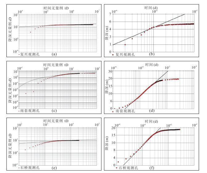
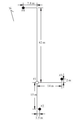
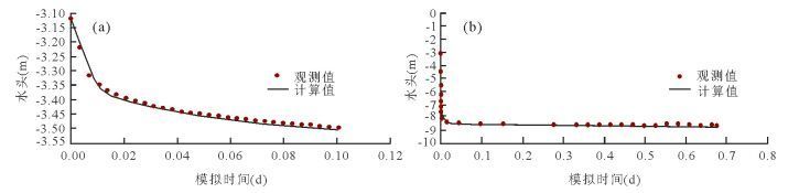
Abstract:
Hydrogeological parameter inversion is very important for the analysis, numerical simulation and forecast, utilization and protection of regional groundwater resource evaluation. However, the relevant researches of Janhan plain are not enough. The Yanglinwei map and the Luxikou map of the Jianghan plain 1:50 000 hydrogeology survey projects were completed in 2015. The widely distributed boreholes had provided reliable information for exploring the local hydrogeological conditions. In this study, pumping test was conducted in three representative boreholes and packer test was conducted in one representative borehole. The software Aquifer Test associated with Theis model and Cooper & Jacob model were used to estimate the aquifer parameters associated with the transient pumping test data. In addition, the Dupuit model was also used to calculate the aquifer parameters with the quasi steady-state pumping test data. Finally, the feasibility and advantages of different methods proposed in this study are also thoroughly discussed. The results show that the hydraulic conductivity of the shallow aquifer in Yanglinwei is 0.075 m/d and the corresponding storage coefficient is 5.8×10⁻². The hydraulic conductivity and the storage coefficient of the deep aquifer are 9.89 m/d and 2.3×10⁻⁵. The hydraulic conductivity and the storage coefficient of the shallow aquifer in Luxikou are 1.26 m/d and 1.1×10⁻¹. The average hydraulic conductivity of the fractured rocks is 0.012 m/d. It was also found that for a pumping test without an observation well, the selected drawdown data inside the well can also be used to estimate the aquifer parameters and the results are reliable.
Hydrogeological parameter inversion is very important for the analysis, numerical simulation and forecast, utilization and protection of regional groundwater resource evaluation. However, the relevant researches of Janhan plain are not enough. The Yanglinwei map and the Luxikou map of the Jianghan plain 1:50 000 hydrogeology survey projects were completed in 2015. The widely distributed boreholes had provided reliable information for exploring the local hydrogeological conditions. In this study, pumping test was conducted in three representative boreholes and packer test was conducted in one representative borehole. The software Aquifer Test associated with Theis model and Cooper & Jacob model were used to estimate the aquifer parameters associated with the transient pumping test data. In addition, the Dupuit model was also used to calculate the aquifer parameters with the quasi steady-state pumping test data. Finally, the feasibility and advantages of different methods proposed in this study are also thoroughly discussed. The results show that the hydraulic conductivity of the shallow aquifer in Yanglinwei is 0.075 m/d and the corresponding storage coefficient is 5.8×10⁻². The hydraulic conductivity and the storage coefficient of the deep aquifer are 9.89 m/d and 2.3×10⁻⁵. The hydraulic conductivity and the storage coefficient of the shallow aquifer in Luxikou are 1.26 m/d and 1.1×10⁻¹. The average hydraulic conductivity of the fractured rocks is 0.012 m/d. It was also found that for a pumping test without an observation well, the selected drawdown data inside the well can also be used to estimate the aquifer parameters and the results are reliable.


2017, 42(5): 734-742.
doi: 10.3799/dqkx.2017.061
Abstract:
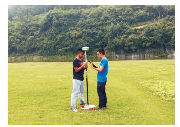
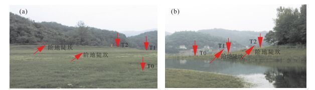
River terraces record the information of environmental changes in the process of river evolution. Proper identification and classification of terraces are of great importance to the paleo-environmental reconstruction and local tectonic evolution. Based on the analysis of drawbacks of the traditional approaches, a terrace extraction method using the unmanned aerial vehicle (UAV) remote sensing is proposed. In this paper, the UAV images and high precision ground control points are used to automatically generate the high resolution DSM (digital surface model) and orthophoto using computer vision-based structure from motion with multi-view stereo photogrammetry (SfM-MVS) techniques. On this basis, the geometric characteristics of river terraces, including the elevation, slope, and image textures are employed to delineate terraces. The proposed method is used to extract the river terraces in the lower reaches of Manhe River, a branch of Hanjiang River. The results show that the terraces extracted with the proposed method have a good agreement with those measured in the field. The proposed method has advantages of high precision and efficiency, and effective visualization for terrace representation. This method provides the technical support for the recognition of terraces, and reveals the potential of UAV remote sensing in geomorphology studies.
River terraces record the information of environmental changes in the process of river evolution. Proper identification and classification of terraces are of great importance to the paleo-environmental reconstruction and local tectonic evolution. Based on the analysis of drawbacks of the traditional approaches, a terrace extraction method using the unmanned aerial vehicle (UAV) remote sensing is proposed. In this paper, the UAV images and high precision ground control points are used to automatically generate the high resolution DSM (digital surface model) and orthophoto using computer vision-based structure from motion with multi-view stereo photogrammetry (SfM-MVS) techniques. On this basis, the geometric characteristics of river terraces, including the elevation, slope, and image textures are employed to delineate terraces. The proposed method is used to extract the river terraces in the lower reaches of Manhe River, a branch of Hanjiang River. The results show that the terraces extracted with the proposed method have a good agreement with those measured in the field. The proposed method has advantages of high precision and efficiency, and effective visualization for terrace representation. This method provides the technical support for the recognition of terraces, and reveals the potential of UAV remote sensing in geomorphology studies.


2017, 42(5): 743-750.
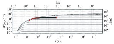
doi: 10.3799/dqkx.2017.062
Abstract:
The aquifer parameters are the necessary basis data for calculation of groundwater resources and prevention of groundwater pollution, therefore it is necessary to invert the parameters with numerical method. According to the standard of 1:50 000 hydrogeological survey, two pumping tests with single pumping well in deep aquifer and two pumping wells in shallow aquifer were conducted at Fuxing Water Works at Yanglinwei Town of Xiantao City in Jianghan plain. The theory of first kind of leakage system was adopted to estimate the parameters in deep aquifer. For the shallow aquifer, a comprehensive well function was derived and the parameters were obtained by using the special type curve matching method and straight line method. In addition, the FEFLOW software has also been used to develop a numerical model for the pumping tests. The parameters were also estimated by the numerical model associated with the pumping test data. The results indicate that the hydraulic conductivity and the specific storage coefficient of the shallow confined aquifer are 21.66-54.00 m/d and 1.28×10⁻⁵ to 8.00×10⁻⁴ m-1, respectively. The hydraulic conductivity and the specific storage coefficient for the deep confined aquifer are 1.27-7.00 m/d and 3.90×10⁻⁶ to 5.00×10⁻⁶ m-1, respectively. The leakage from the third aquitard layer is significant, which should be taken into account for the analysis of the pumping test. In this paper, the numerical model is developed to estimate the aquifer parameters associated with the pumping test data, the structure of the aquifer was considered in detail in the numerical model. The good agreement between the simulated results and the measured data indicate that the results obtained from the numerical simulation are reliable.
The aquifer parameters are the necessary basis data for calculation of groundwater resources and prevention of groundwater pollution, therefore it is necessary to invert the parameters with numerical method. According to the standard of 1:50 000 hydrogeological survey, two pumping tests with single pumping well in deep aquifer and two pumping wells in shallow aquifer were conducted at Fuxing Water Works at Yanglinwei Town of Xiantao City in Jianghan plain. The theory of first kind of leakage system was adopted to estimate the parameters in deep aquifer. For the shallow aquifer, a comprehensive well function was derived and the parameters were obtained by using the special type curve matching method and straight line method. In addition, the FEFLOW software has also been used to develop a numerical model for the pumping tests. The parameters were also estimated by the numerical model associated with the pumping test data. The results indicate that the hydraulic conductivity and the specific storage coefficient of the shallow confined aquifer are 21.66-54.00 m/d and 1.28×10⁻⁵ to 8.00×10⁻⁴ m-1, respectively. The hydraulic conductivity and the specific storage coefficient for the deep confined aquifer are 1.27-7.00 m/d and 3.90×10⁻⁶ to 5.00×10⁻⁶ m-1, respectively. The leakage from the third aquitard layer is significant, which should be taken into account for the analysis of the pumping test. In this paper, the numerical model is developed to estimate the aquifer parameters associated with the pumping test data, the structure of the aquifer was considered in detail in the numerical model. The good agreement between the simulated results and the measured data indicate that the results obtained from the numerical simulation are reliable.


2017, 42(5): 751-760.
doi: 10.3799/dqkx.2017.063
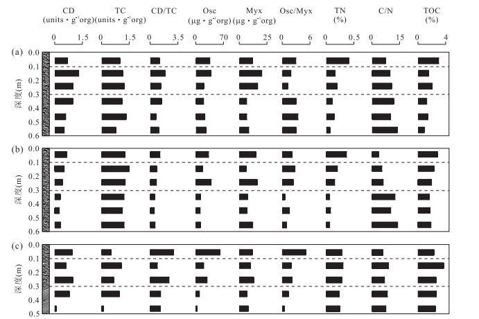
Abstract:
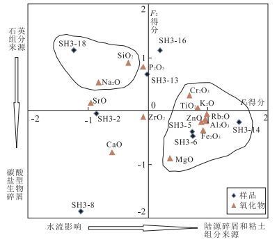
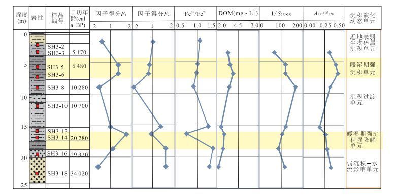
Hydrate-bearing sediments are the fundamental elements for the study of Earth Critical Zone. To broaden the studying dimensions of groundwater environmental problems, 14C dating, δ13C, iron valance and spectroscopic information of dissolved organic matter (DOM) in Shahu sediment profile were employed to characterize the evolution of sedimentary environment of 30 000 years in Jianghan plain. The values of Zr/Rb, Rb/Sr and δ13C indicate that the climates are much warmer and wetter in the periods of sediments formation in 5 to 7 m and 16 to 18 m than others; the ratio of Fe3+/Fe2+ states that sediments in the two periods is mainly in reductive environment. The evolution of sedimentary environment is generalized into five units including unit of weak bioclastic deposition near-surface, unit of strong deposition in warm and wet period based on the factor analysis and spectroscopic information of DOM. Evolution of Quaternary sedimentary environment suggested by sediment profile at Shahu provides essential data for researches on the regional groundwater environmental problems.
Hydrate-bearing sediments are the fundamental elements for the study of Earth Critical Zone. To broaden the studying dimensions of groundwater environmental problems, 14C dating, δ13C, iron valance and spectroscopic information of dissolved organic matter (DOM) in Shahu sediment profile were employed to characterize the evolution of sedimentary environment of 30 000 years in Jianghan plain. The values of Zr/Rb, Rb/Sr and δ13C indicate that the climates are much warmer and wetter in the periods of sediments formation in 5 to 7 m and 16 to 18 m than others; the ratio of Fe3+/Fe2+ states that sediments in the two periods is mainly in reductive environment. The evolution of sedimentary environment is generalized into five units including unit of weak bioclastic deposition near-surface, unit of strong deposition in warm and wet period based on the factor analysis and spectroscopic information of DOM. Evolution of Quaternary sedimentary environment suggested by sediment profile at Shahu provides essential data for researches on the regional groundwater environmental problems.


2017, 42(5): 761-770.
doi: 10.3799/dqkx.2017.064
Abstract:
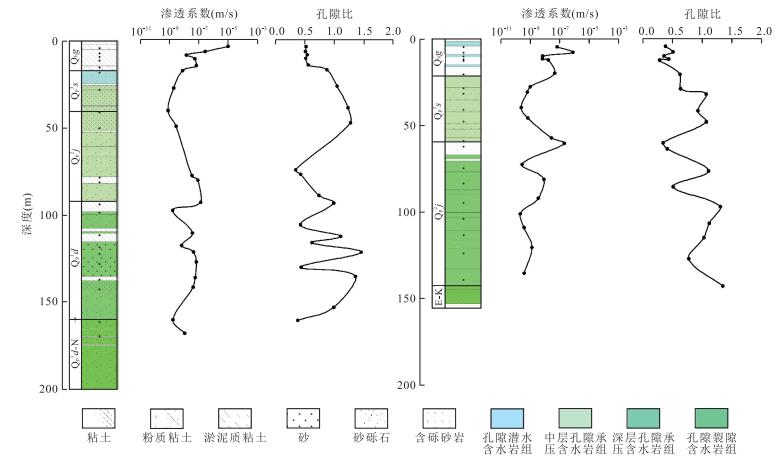
The hydraulic conductivity of aquitard is an important parameter for the regional groundwater flow system and the effect of water-soil-biology in critical zone. Taking the 1:50 000 Yanglinwei-Luxikou in Jianghan plain as typical study area combining with the investigation of critical zone, 52 sediment samples from different depth and lithology were collected to conduct the laboratorial penetration test with improved permeameter, and amend the empirical formula of clay with K and granularity characteristic parameters. The results show that: the hydraulic conductivity of sediments related to lithology and large variability, range from 10-10 to 10-6 m/s; pore phreatic aquifer group mainly consists of silty clay and clay, hydraulic conductivity and variability is small, sedimentary environment is relatively stable; artesian aquifer group due to the continuous distribution of clay and silt, leading to large hydraulic conductivity and variability, present multicycle sedimentary environment of typical river-lake interaction. Utilize the significant binomial relation with effective pore ratio (eu) and clay content (P), amend Terzaghi's empirical formula, and predicted data and experimental data are coincided basically, the range of specific value is less than an order of magnitude, validating the feasibility of amended Terzaghi's formula in river-lake plain.
The hydraulic conductivity of aquitard is an important parameter for the regional groundwater flow system and the effect of water-soil-biology in critical zone. Taking the 1:50 000 Yanglinwei-Luxikou in Jianghan plain as typical study area combining with the investigation of critical zone, 52 sediment samples from different depth and lithology were collected to conduct the laboratorial penetration test with improved permeameter, and amend the empirical formula of clay with K and granularity characteristic parameters. The results show that: the hydraulic conductivity of sediments related to lithology and large variability, range from 10-10 to 10-6 m/s; pore phreatic aquifer group mainly consists of silty clay and clay, hydraulic conductivity and variability is small, sedimentary environment is relatively stable; artesian aquifer group due to the continuous distribution of clay and silt, leading to large hydraulic conductivity and variability, present multicycle sedimentary environment of typical river-lake interaction. Utilize the significant binomial relation with effective pore ratio (eu) and clay content (P), amend Terzaghi's empirical formula, and predicted data and experimental data are coincided basically, the range of specific value is less than an order of magnitude, validating the feasibility of amended Terzaghi's formula in river-lake plain.


2017, 42(5): 771-782.
doi: 10.3799/dqkx.2017.065
Abstract:
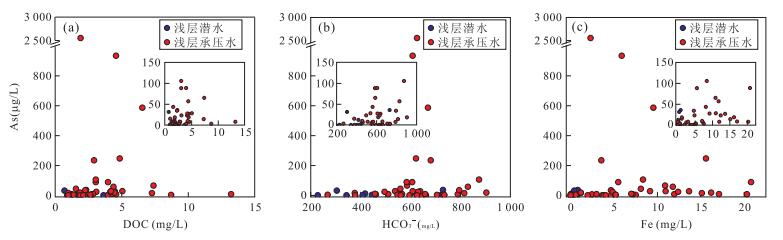
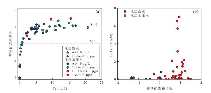
Dissolved organic matter (DOM) is one of the key factors controlling the release of arsenic from sediment to groundwater. There are abundant surface water systems with rivers, lakes, streams and ponds in the Jianghan plain, densely covered by irrigation canals and ditches. The interactions between surface water and shallow groundwater may significantly affect the characteristics and strength of DOM in water. In order to elaborate the roles of DOM on arsenic mobilization in groundwater of Jianghan plain, this study analyzes surface water and groundwater samples using excitation-emission matrix spectroscopy (EEMs) and characterizes the dissolved organic matter of its functional groups, molecular, fluorescence using PARAFAC (parallel factor analysis). It is found that dissolved organic matter in Jianghan plain mainly includes three different components, of which C1 and C2 are humic-like substances and C3 is characterized by protein-like substances. The main components of dissolved organic matter in groundwater are C1 and C2, whilst the dissolved organic matter in surface water is mostly C2 and C3. Dissolved organic matter in groundwater dominated by terrestrial materials, promotes the mobilization of arsenic in two ways. (1) The humic substances act as an electron shuttle for microbial communities, promoting the microbially mediated oxidation of organic matter and reduction of Fe oxides with the release of arsenic and the production of large amounts of DOC (dissolved organic carbon)and HCO3-; (2) Complexation of As with DOM via the bridging of metal cations (such as Fe) enhances the mobility of As in groundwater.
Dissolved organic matter (DOM) is one of the key factors controlling the release of arsenic from sediment to groundwater. There are abundant surface water systems with rivers, lakes, streams and ponds in the Jianghan plain, densely covered by irrigation canals and ditches. The interactions between surface water and shallow groundwater may significantly affect the characteristics and strength of DOM in water. In order to elaborate the roles of DOM on arsenic mobilization in groundwater of Jianghan plain, this study analyzes surface water and groundwater samples using excitation-emission matrix spectroscopy (EEMs) and characterizes the dissolved organic matter of its functional groups, molecular, fluorescence using PARAFAC (parallel factor analysis). It is found that dissolved organic matter in Jianghan plain mainly includes three different components, of which C1 and C2 are humic-like substances and C3 is characterized by protein-like substances. The main components of dissolved organic matter in groundwater are C1 and C2, whilst the dissolved organic matter in surface water is mostly C2 and C3. Dissolved organic matter in groundwater dominated by terrestrial materials, promotes the mobilization of arsenic in two ways. (1) The humic substances act as an electron shuttle for microbial communities, promoting the microbially mediated oxidation of organic matter and reduction of Fe oxides with the release of arsenic and the production of large amounts of DOC (dissolved organic carbon)and HCO3-; (2) Complexation of As with DOM via the bridging of metal cations (such as Fe) enhances the mobility of As in groundwater.


2017, 42(5): 783-792.
doi: 10.3799/dqkx.2017.066
Abstract:
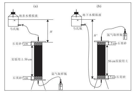
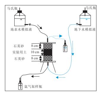
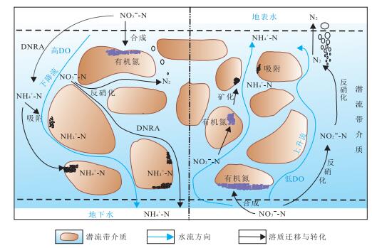
At present, the situation of water nitrogen pollution in the world is grim, and nitrate (NO3--N) pollution is the main form. To study the effects of groundwater and surface water (G-S) interaction on the migration and transformation of NO3--N in the hyporheic zone (HZ) is the key for comprehensive prevention and control of water nitrogen pollution. Three modes of NO3--N migration and transformation experiments, including surface water (S) supply for groundwater (G) (down-welling), groundwater (G) supply for surface water (S) (up-welling) and the alternative mode, were carried out in the study. It is found that NO3--N concentration of three modes effluent can be reduced more than 95%; the strength of denitrification in up-welling was greater than in down-welling; the contribution of the dissimilation reduction (DNRA) to the ammonia nitrogen (NH4+-N) concentration in the outflow of down-welling and up-welling was about 71% and 11%, respectively. After up-welling experiment, the organic nitrogen content of water-soil interface was 2.3 times as much as the down-welling experiment. It was shown that the NO3--N attenuation pathways under the G-S interaction mainly include denitrification, DNRA and the synthesis of organic nitrogen; G-S interaction modes had effects on the strength of each NO3--N attenuation pathway; HZ media could intercept nitrogen through the adsorption of NH4+-N and microbial synthesis of organic nitrogen.
At present, the situation of water nitrogen pollution in the world is grim, and nitrate (NO3--N) pollution is the main form. To study the effects of groundwater and surface water (G-S) interaction on the migration and transformation of NO3--N in the hyporheic zone (HZ) is the key for comprehensive prevention and control of water nitrogen pollution. Three modes of NO3--N migration and transformation experiments, including surface water (S) supply for groundwater (G) (down-welling), groundwater (G) supply for surface water (S) (up-welling) and the alternative mode, were carried out in the study. It is found that NO3--N concentration of three modes effluent can be reduced more than 95%; the strength of denitrification in up-welling was greater than in down-welling; the contribution of the dissimilation reduction (DNRA) to the ammonia nitrogen (NH4+-N) concentration in the outflow of down-welling and up-welling was about 71% and 11%, respectively. After up-welling experiment, the organic nitrogen content of water-soil interface was 2.3 times as much as the down-welling experiment. It was shown that the NO3--N attenuation pathways under the G-S interaction mainly include denitrification, DNRA and the synthesis of organic nitrogen; G-S interaction modes had effects on the strength of each NO3--N attenuation pathway; HZ media could intercept nitrogen through the adsorption of NH4+-N and microbial synthesis of organic nitrogen.


2017, 42(5): 793-803.
doi: 10.3799/dqkx.2017.067
Abstract:
The hydraulic conductivity (K) of deposits is one of the important and fundamental properties for solving various problems in the study filed of hydrogeology and geotechenical engineering. However, in the study of clay-rich deposits, the selection of the evaluation method for K is obviously affected by the scale of the site and the degree of deposits disturbance due to the complex deposit structure. Chemical (δ18O as the tracer), laboratory, and empirical formula methods were used to predict the vertical hydraulic conductivity in saturated clay-rich deposits, and their practicability was analyzed. Take the Quaternary thick clay-rich sediments in North Jiangsu coastal plain for example, the estimated hydraulic conductivity of the thick clay-rich sediments was lower than 1×10-11 m/s using δ18O chemical methods. Using laboratory method, that range between 2.61×10⁻⁸ and 9×10-12 m/s. The larger predictive values were determined by empirical formula method and higher than that obtained using hydraulic method by several times. Chemical method was applied to display the long-term experimental results under the natural conditions, and the equivalent permeability of the decade meters clay-rich deposits. Besides, the residence time of pore water in the sediments was also predicted. Combined with the laboratory parameters of clay samples, such as liquid and plastic limit, laboratory and empirical formula methods could provide series hydraulic conductivities of the whole profile, in order to show the difference of different permeability coefficient prediction methods in thick clay-rich profile.
The hydraulic conductivity (K) of deposits is one of the important and fundamental properties for solving various problems in the study filed of hydrogeology and geotechenical engineering. However, in the study of clay-rich deposits, the selection of the evaluation method for K is obviously affected by the scale of the site and the degree of deposits disturbance due to the complex deposit structure. Chemical (δ18O as the tracer), laboratory, and empirical formula methods were used to predict the vertical hydraulic conductivity in saturated clay-rich deposits, and their practicability was analyzed. Take the Quaternary thick clay-rich sediments in North Jiangsu coastal plain for example, the estimated hydraulic conductivity of the thick clay-rich sediments was lower than 1×10-11 m/s using δ18O chemical methods. Using laboratory method, that range between 2.61×10⁻⁸ and 9×10-12 m/s. The larger predictive values were determined by empirical formula method and higher than that obtained using hydraulic method by several times. Chemical method was applied to display the long-term experimental results under the natural conditions, and the equivalent permeability of the decade meters clay-rich deposits. Besides, the residence time of pore water in the sediments was also predicted. Combined with the laboratory parameters of clay samples, such as liquid and plastic limit, laboratory and empirical formula methods could provide series hydraulic conductivities of the whole profile, in order to show the difference of different permeability coefficient prediction methods in thick clay-rich profile.


Hydrochemical Characteristics and Evolution of Karst Groundwater in Sanqiao District of Guiyang City
2017, 42(5): 804-812.
doi: 10.3799/dqkx.2017.068
Abstract:
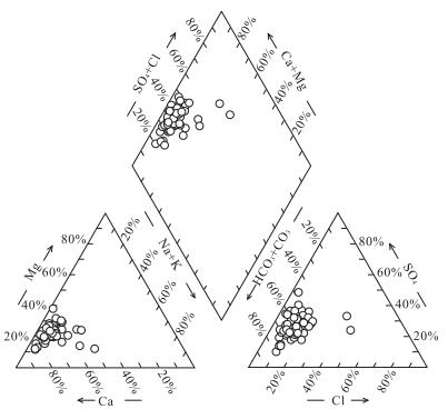
The karst groundwater in Sanqiao district of Guiyang City is the main water sources for local people, and the development of karst system in Guiyang is very complicated. However, the study of karst water chemistry and its evolutionary characteristics, especially water-rock interaction, has not been reported. In order to ensure the safety of water supply in the region, chemical components and hydrogen and oxygen isotopic data of the groundwater in the Sanqiao district of Guiyang are combined to determine the spatial distribution and evolution of chemical components in groundwater and distinguish the water-rock interaction processes in this study. It is found that the hydrochemical type of groundwater can be classified into HCO3·SO4-Ca·Mg, HCO3·SO4-Ca, HCO3-Ca and HCO3-Ca·Mg. The hydrogen and oxygen isotopes of groundwater show that the recharge of groundwater in research area is precipitation. Besides, hydrogeochemical simulation shows that the hydrochemical characteristics are controlled by the solution of calcite, dolomite, halite and gypsum as well as cation exchange.
The karst groundwater in Sanqiao district of Guiyang City is the main water sources for local people, and the development of karst system in Guiyang is very complicated. However, the study of karst water chemistry and its evolutionary characteristics, especially water-rock interaction, has not been reported. In order to ensure the safety of water supply in the region, chemical components and hydrogen and oxygen isotopic data of the groundwater in the Sanqiao district of Guiyang are combined to determine the spatial distribution and evolution of chemical components in groundwater and distinguish the water-rock interaction processes in this study. It is found that the hydrochemical type of groundwater can be classified into HCO3·SO4-Ca·Mg, HCO3·SO4-Ca, HCO3-Ca and HCO3-Ca·Mg. The hydrogen and oxygen isotopes of groundwater show that the recharge of groundwater in research area is precipitation. Besides, hydrogeochemical simulation shows that the hydrochemical characteristics are controlled by the solution of calcite, dolomite, halite and gypsum as well as cation exchange.


2017, 42(5): 813-820.
doi: 10.3799/dqkx.2017.069
Abstract:
Groundwater flow system theory and numerical simulation technique are foundamentals in hydrogeology. Generalizing aquifer group is an important foundation for groundwater flow system analysis and numerical simulation, which directly affects the accuracy and the reliability of the simulation results. This paper proposes a new method named cumulative transmissivity to generalize aquifer group, aiming at improving the generalization accuracy and reliability. The new method is characterized by aquifer structure based on the changes of the accumulated transmissivity (product of hydraulic conductivity and its thickness) with depth and the integral characteristics of the hydrogeological profile. A case study in the Manas River basin is presented in this paper. Based on the generalization, a hydrogeological structure model is built using the GMS software and its TINS module. The results indicate that the aquifer structures generalized using this method have a high rationality and fidelity. The 3D model well displays the spatial distribution of the aquifers and auitards in the study area and provides a good foundation for groundwater flow model.
Groundwater flow system theory and numerical simulation technique are foundamentals in hydrogeology. Generalizing aquifer group is an important foundation for groundwater flow system analysis and numerical simulation, which directly affects the accuracy and the reliability of the simulation results. This paper proposes a new method named cumulative transmissivity to generalize aquifer group, aiming at improving the generalization accuracy and reliability. The new method is characterized by aquifer structure based on the changes of the accumulated transmissivity (product of hydraulic conductivity and its thickness) with depth and the integral characteristics of the hydrogeological profile. A case study in the Manas River basin is presented in this paper. Based on the generalization, a hydrogeological structure model is built using the GMS software and its TINS module. The results indicate that the aquifer structures generalized using this method have a high rationality and fidelity. The 3D model well displays the spatial distribution of the aquifers and auitards in the study area and provides a good foundation for groundwater flow model.


2017, 42(5): 821-831.
doi: 10.3799/dqkx.2017.070
Abstract:
Water quality of Jinan spring catchment is getting worse year by year. It is of great significance to find out the pollution sources and influence factors for exploitation of the karst water and ecological environment protection. However, analysis of the whole karst water system including the recharge and runoff area has not been reported yet. Hydrochemical method (piper diagram, ion ratio, correlation analysis) and multivariate statistical method (factor analysis and cluster analysis) were comprehensively used to analyze the hydrochemical characteristics of groundwater, as well as the factors affecting water quality and relevant impact strength in different areas in this study. Factor analysis indicates the effects of water-rock interaction between limestone and groundwater, industrial and domestic pollution, water-rock interaction between dolomite and groundwater, and agriculture, husbandry and domestic pollution. Their contribution rates to groundwater quality are 33.1%, 28.4%, 12.0%, and 11.8%, respectively. Combined with hydrochemical and cluster analyses, the results indicate that groundwater quality in the study area is controlled by both water-rock interaction and anthropogenic activities. Groundwater with high quality in the southern recharge area and western discharge area is mainly affected by the dissolution of carbonate minerals. Some parts of the recharge-runoff area are influenced by agriculture, husbandry and rural domestic pollution with higher content of nitrate in the groundwater. Industrial and urban domestic pollution severely impacts the eastern suburb, urban and suburban exploitation area with poor groundwater quality and excessive levels of SO42-, NO3-, TDS and total hardness in a few sections.
Water quality of Jinan spring catchment is getting worse year by year. It is of great significance to find out the pollution sources and influence factors for exploitation of the karst water and ecological environment protection. However, analysis of the whole karst water system including the recharge and runoff area has not been reported yet. Hydrochemical method (piper diagram, ion ratio, correlation analysis) and multivariate statistical method (factor analysis and cluster analysis) were comprehensively used to analyze the hydrochemical characteristics of groundwater, as well as the factors affecting water quality and relevant impact strength in different areas in this study. Factor analysis indicates the effects of water-rock interaction between limestone and groundwater, industrial and domestic pollution, water-rock interaction between dolomite and groundwater, and agriculture, husbandry and domestic pollution. Their contribution rates to groundwater quality are 33.1%, 28.4%, 12.0%, and 11.8%, respectively. Combined with hydrochemical and cluster analyses, the results indicate that groundwater quality in the study area is controlled by both water-rock interaction and anthropogenic activities. Groundwater with high quality in the southern recharge area and western discharge area is mainly affected by the dissolution of carbonate minerals. Some parts of the recharge-runoff area are influenced by agriculture, husbandry and rural domestic pollution with higher content of nitrate in the groundwater. Industrial and urban domestic pollution severely impacts the eastern suburb, urban and suburban exploitation area with poor groundwater quality and excessive levels of SO42-, NO3-, TDS and total hardness in a few sections.


2017, 42(5): 832-842.
doi: 10.3799/dqkx.2017.071
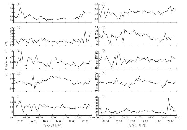
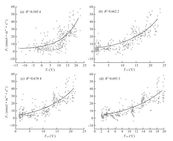
Abstract:
It is significant to do research on methane flux in Dajiuhu, to understand mechanism of the carbon cycle better, to manage it more scientifically and to assess the carbon balance in wetland ecosystem accurately. By using eddy covariance technique, methane fluxes of Dajiuhu subalpine peatland in Shennongjia Forestry Administrative District of Hubei Province, Central China were observed from August 2015 to May 2016, and temporal variation of methane emission and related affecting factors were investigated. The results show that the peatland ecosystem was methane sources, with the daily average release rate being 15.57 nmol·m-2·s-1. During the sampling period, the mean diurnal variations showed a maximum value at night (2:00 or 22:00) and a three-peak pattern all day (6:00, 12:00 and 22:00). The monthly average emission rate of CH4 decreased rapidly from August(36.46 nmol·m-2·s-1), and its valley in March(3.92 nmol·m-2·s-1), then increasing gradually from April. The correlation analysis indicates that CH4 flux was mainly dominated by air temperature (Ta), soil temperature (Ts), soil water content (SWC) and friction velocity (U*). And their relevance varied with different time scales. The curve fitting shows that CH4 flux was an exponential correlated with Ta and Ts, and had a good conic relationship with SWC.
It is significant to do research on methane flux in Dajiuhu, to understand mechanism of the carbon cycle better, to manage it more scientifically and to assess the carbon balance in wetland ecosystem accurately. By using eddy covariance technique, methane fluxes of Dajiuhu subalpine peatland in Shennongjia Forestry Administrative District of Hubei Province, Central China were observed from August 2015 to May 2016, and temporal variation of methane emission and related affecting factors were investigated. The results show that the peatland ecosystem was methane sources, with the daily average release rate being 15.57 nmol·m-2·s-1. During the sampling period, the mean diurnal variations showed a maximum value at night (2:00 or 22:00) and a three-peak pattern all day (6:00, 12:00 and 22:00). The monthly average emission rate of CH4 decreased rapidly from August(36.46 nmol·m-2·s-1), and its valley in March(3.92 nmol·m-2·s-1), then increasing gradually from April. The correlation analysis indicates that CH4 flux was mainly dominated by air temperature (Ta), soil temperature (Ts), soil water content (SWC) and friction velocity (U*). And their relevance varied with different time scales. The curve fitting shows that CH4 flux was an exponential correlated with Ta and Ts, and had a good conic relationship with SWC.


2017, 42(5): 843-852.
doi: 10.3799/dqkx.2017.072
Abstract:
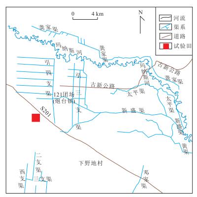
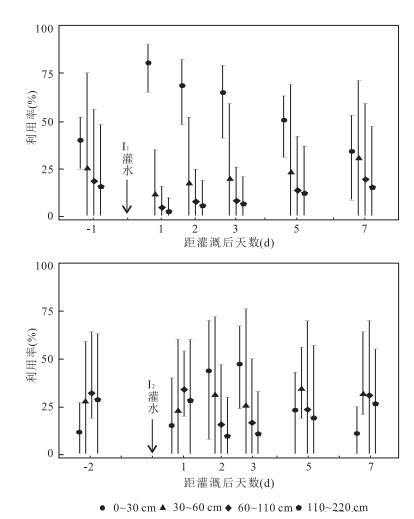
Cotton is the main crop in arid areas of Northwest China. Study on the water sources of crops is of great significance to make proper irrigation schedules and realize agricultural water-saving irrigation in arid regions. In this study, precipitation, irrigation water, soil water and cotton stem water were sampled for stable isotope analysis in the Paotai Soil Improvement Test Station in Xinjiang Production and Construction Corps. Based on the stable hydrogen and oxygen isotopic tracing method and hydrological observations, the dynamic variation of stable isotope values in soil water under mulched drip irrigation was analyzed to determine the water sources of the cotton in different growth stages and the sources after irrigation pulse. The contributions of soil water at different depths to cotton water uptake were quantified by the IsoSource model. Results show that the main uptake depth of soil water in bud stage, blooming stage, boll stage and open boll stage are distributed in 0 to 30 cm layer (78.2%), 30 to 60 cm layer(31.9%), 60 to 110 cm layer(32%)and 110 to 220 cm(47.3%), respectively. The main sources of water used by cotton gradually increase with the advance of growth stage. Cotton adjusts rapidly water sources after mulched drip irrigation, by significantly increasing the proportions of water use in 0 to 30 cm soil. The results also indicate that the proper irrigation schedule with low irrigation volume and high irrigation frequency can improve the utilization efficiency of irrigation water in arid regions.
Cotton is the main crop in arid areas of Northwest China. Study on the water sources of crops is of great significance to make proper irrigation schedules and realize agricultural water-saving irrigation in arid regions. In this study, precipitation, irrigation water, soil water and cotton stem water were sampled for stable isotope analysis in the Paotai Soil Improvement Test Station in Xinjiang Production and Construction Corps. Based on the stable hydrogen and oxygen isotopic tracing method and hydrological observations, the dynamic variation of stable isotope values in soil water under mulched drip irrigation was analyzed to determine the water sources of the cotton in different growth stages and the sources after irrigation pulse. The contributions of soil water at different depths to cotton water uptake were quantified by the IsoSource model. Results show that the main uptake depth of soil water in bud stage, blooming stage, boll stage and open boll stage are distributed in 0 to 30 cm layer (78.2%), 30 to 60 cm layer(31.9%), 60 to 110 cm layer(32%)and 110 to 220 cm(47.3%), respectively. The main sources of water used by cotton gradually increase with the advance of growth stage. Cotton adjusts rapidly water sources after mulched drip irrigation, by significantly increasing the proportions of water use in 0 to 30 cm soil. The results also indicate that the proper irrigation schedule with low irrigation volume and high irrigation frequency can improve the utilization efficiency of irrigation water in arid regions.