2017 Vol. 42, No. 9
Display Method:
 PDF 255KB
2017, 42(9): 1441-1453.
doi: 10.3799/dqkx.2017.109
Abstract:
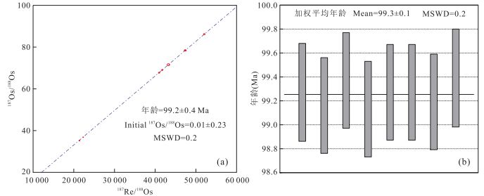
The Bangong-Nujiang metallogenic belt is a new discovery with obvious prospecting breakthrough in the last ten years, mainly including porphyry-skarn and porphyry-hypothermal types Cu-Au deposits, which are poorly studied. The Rongga deposit located at the western segment of south Bangong-Nujiang suture zone, is the first porphyry Mo deposit discovered in 2016 that has a perspective large scale in the Bangong-Nujiang metallogenic belt. The Rongga deposit yielded a molybdenite Re-Os weighted mean age of 99.3±0.1 Ma (MSWD=0.2, n=8), consistent with the isochron age of 99.2±0.4 Ma (MSWD=0.2, n=8), which indicated the mineralization occurred at early stage of Late Cretaceous during the collision between Lhasa and Qiangtang terranes when the subducted Bangong-Nujiang oceanic crust has closed. This discovery of Rongga deposit has enriched the knowledge of metallogenic theory, filled the gap of Mo resources in this region, and the existed models are challenged in the Bangong-Nujiang belt. This discovery of Rongga deposit show the potential for porphyry Mo mineralization along the Bangong-Nujiang suture zone, and provide an example illustration and theoretical support for further exploration of porphyry Mo deposit in this belt.
The Bangong-Nujiang metallogenic belt is a new discovery with obvious prospecting breakthrough in the last ten years, mainly including porphyry-skarn and porphyry-hypothermal types Cu-Au deposits, which are poorly studied. The Rongga deposit located at the western segment of south Bangong-Nujiang suture zone, is the first porphyry Mo deposit discovered in 2016 that has a perspective large scale in the Bangong-Nujiang metallogenic belt. The Rongga deposit yielded a molybdenite Re-Os weighted mean age of 99.3±0.1 Ma (MSWD=0.2, n=8), consistent with the isochron age of 99.2±0.4 Ma (MSWD=0.2, n=8), which indicated the mineralization occurred at early stage of Late Cretaceous during the collision between Lhasa and Qiangtang terranes when the subducted Bangong-Nujiang oceanic crust has closed. This discovery of Rongga deposit has enriched the knowledge of metallogenic theory, filled the gap of Mo resources in this region, and the existed models are challenged in the Bangong-Nujiang belt. This discovery of Rongga deposit show the potential for porphyry Mo mineralization along the Bangong-Nujiang suture zone, and provide an example illustration and theoretical support for further exploration of porphyry Mo deposit in this belt.


2017, 42(9): 1454-1471.
doi: 10.3799/dqkx.2017.517
Abstract:
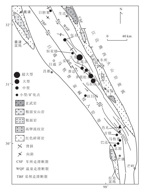
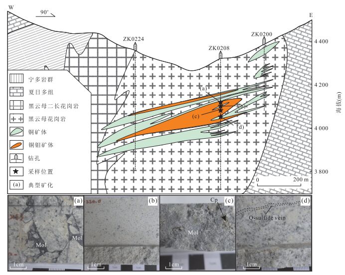
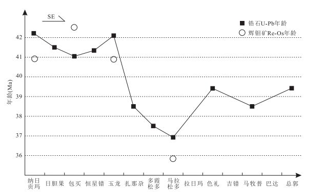
Baomai porphyry copper-molybdenite deposit is an important part of the northern Yulong copper belt, Tibet, with typical porphyry-type mineralization and alteration. The latest exploration shows that both Cu and Mo resources have reached the medium-sized deposit, but the research work is still very poor. Based on the basic geological characteristics, intrusion ages of biotite granite porphyry and biotit-monzogranite are 41.3±0.2 Ma and 40.8±0.2 Ma, respectively, according to the LA-ICP-MS zircon U-Pb geochronology method. These results are consistent with those of Yulong and Zhanaga deposits. All of them are the products of continent collision orogeny of India with Eurasia in Eocene. Geochronology evidences show that porphyries related to mineralization in the Yulong copper belt are mainly intruded at 37-42 Ma, and no obviously early (51 Ma), medium (41 Ma) and late (33 Ma) stages magmatic activities. From northwest to southeast, the ages of diagenesis and mineralization in Yulong copper belt do not change to be younger significantly.
Baomai porphyry copper-molybdenite deposit is an important part of the northern Yulong copper belt, Tibet, with typical porphyry-type mineralization and alteration. The latest exploration shows that both Cu and Mo resources have reached the medium-sized deposit, but the research work is still very poor. Based on the basic geological characteristics, intrusion ages of biotite granite porphyry and biotit-monzogranite are 41.3±0.2 Ma and 40.8±0.2 Ma, respectively, according to the LA-ICP-MS zircon U-Pb geochronology method. These results are consistent with those of Yulong and Zhanaga deposits. All of them are the products of continent collision orogeny of India with Eurasia in Eocene. Geochronology evidences show that porphyries related to mineralization in the Yulong copper belt are mainly intruded at 37-42 Ma, and no obviously early (51 Ma), medium (41 Ma) and late (33 Ma) stages magmatic activities. From northwest to southeast, the ages of diagenesis and mineralization in Yulong copper belt do not change to be younger significantly.


2017, 42(9): 1472-1494.
doi: 10.3799/dqkx.2017.545
Abstract:
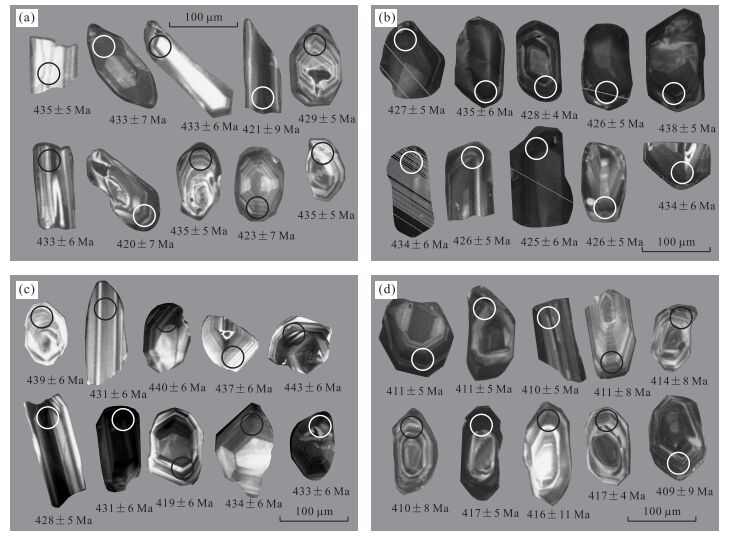
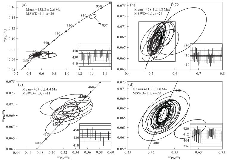
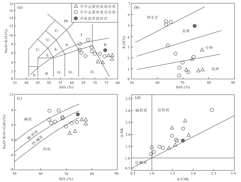
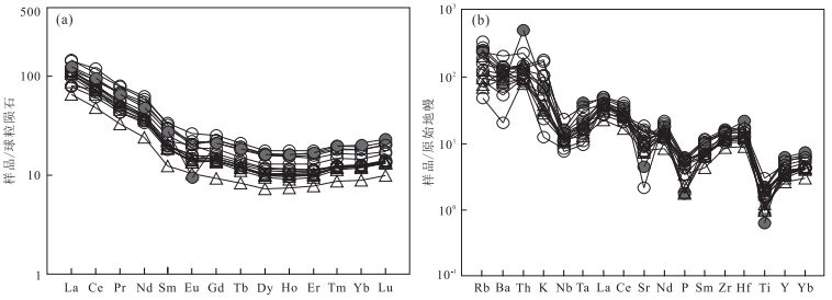
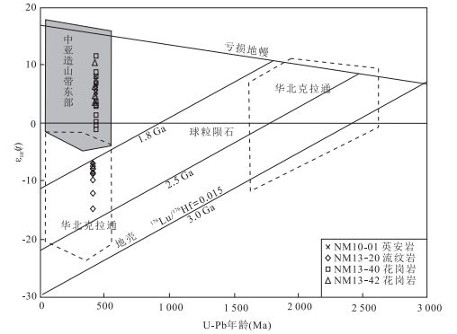
There are some existing debates about the tectonic history of the Central Asian Orogenic Belt, including the time of collision.New zircon SHRIMP and LA-ICP-MS U-Pb isotopic data, zircon Lu-Hf isotopic data and geochemical data of the volcanic rocks and plutons from the Eerdengtaolegai area are presented to study their formation ages and petrogenesis.Zircon U-Pb ages of 432.8±2.6 Ma, 428.1±1.8 Ma of Silurian granites, 434.0±4.4 Ma of Silurian dacite, 411.8±1.0 Ma of the Devonian rhyolite were obtained.The Silurian plutons are mostly intermediate-acid rocks, and are geochemically low in K contents, peraluminous, and calc-alkaline with enrichment in Rb and Th and depletion in Nb, Ta, P and Ti.They do not have negative Eu anomalies. Two granites from these plutonic rocks have positive εHf(t) values (-1.19 to 11.51 and 3.32 to 10.28) with TMD2 of 684-1 493 Ma and 759-1 202 Ma, suggesting that the granites may come from a juvenile continental crust.Geochemically, the Silurian volcanic rocks, all acid rocks, are low to moderate in K content, metaluminous-peraluminous and calc-alkaline with enrichment in Rb, Th and depletion in Nb, Ta, P and Ti.In addition, they do net have negative Eu anomalies. One Silurian dacite has positive εHf(t) value (3.70-7.94) with TMD2 of 912-1 183 Ma, suggesting that the rocks may come from the juvenile continental crust.The Devonian rhyolite have clear negative Eu anomalies, exhibiting negative εHf(t) values (-14.95 to -7.07) with Hf model ages (TMD2) of 1.8-2.3 Ga, indicating considerable contribution of reworked materials from the ancient crust of the North China Craton.Based on our new data and previous studies, the Silurian granites and dacite were likely formed in an arc environment and the Devonian rhyolite developed in a post-collisional environment.
There are some existing debates about the tectonic history of the Central Asian Orogenic Belt, including the time of collision.New zircon SHRIMP and LA-ICP-MS U-Pb isotopic data, zircon Lu-Hf isotopic data and geochemical data of the volcanic rocks and plutons from the Eerdengtaolegai area are presented to study their formation ages and petrogenesis.Zircon U-Pb ages of 432.8±2.6 Ma, 428.1±1.8 Ma of Silurian granites, 434.0±4.4 Ma of Silurian dacite, 411.8±1.0 Ma of the Devonian rhyolite were obtained.The Silurian plutons are mostly intermediate-acid rocks, and are geochemically low in K contents, peraluminous, and calc-alkaline with enrichment in Rb and Th and depletion in Nb, Ta, P and Ti.They do not have negative Eu anomalies. Two granites from these plutonic rocks have positive εHf(t) values (-1.19 to 11.51 and 3.32 to 10.28) with TMD2 of 684-1 493 Ma and 759-1 202 Ma, suggesting that the granites may come from a juvenile continental crust.Geochemically, the Silurian volcanic rocks, all acid rocks, are low to moderate in K content, metaluminous-peraluminous and calc-alkaline with enrichment in Rb, Th and depletion in Nb, Ta, P and Ti.In addition, they do net have negative Eu anomalies. One Silurian dacite has positive εHf(t) value (3.70-7.94) with TMD2 of 912-1 183 Ma, suggesting that the rocks may come from the juvenile continental crust.The Devonian rhyolite have clear negative Eu anomalies, exhibiting negative εHf(t) values (-14.95 to -7.07) with Hf model ages (TMD2) of 1.8-2.3 Ga, indicating considerable contribution of reworked materials from the ancient crust of the North China Craton.Based on our new data and previous studies, the Silurian granites and dacite were likely formed in an arc environment and the Devonian rhyolite developed in a post-collisional environment.


2017, 42(9): 1495-1507.
doi: 10.3799/dqkx.2017.500
Abstract:
The formation of the Dongxiang copper deposit has been hotly debated for the last 20 years. In particular, the origin of the Dongxiang Cu deposit was controversial, with models ranging from Hercynian SEDEX (sedimentary exhalative deposit) to Yanshanian magmatic hydrothermal origins. Accurate dating on the mineralization and associated igneous rocks is a key to solve this problem. Using Rb-Sr isochron method on quartz (fluid inclusions) samples from the massive sulfide ore, an ore formation age of 161.8±9.6 Ma (MSDW=1.3) was obtained. Intrusive rocks (i.e., granodiorite-porphyry specially related to Cu ore-forming) in Dongxiang region was also studied. The zircon U-Pb ages are 164±2 Ma and 160±1 Ma for granodiorite porphyry. These results indicate that the metallogenic epoch of the Dongxiang copper deposit occurred in the Yanshanian. Combined with fluid inclusion results and regional metallogeny, it is proposed that the Dongxiang copper deposit was related to magmatic hydrothermal activities associated with the Yanshanian intrusive porphyries nearby.
The formation of the Dongxiang copper deposit has been hotly debated for the last 20 years. In particular, the origin of the Dongxiang Cu deposit was controversial, with models ranging from Hercynian SEDEX (sedimentary exhalative deposit) to Yanshanian magmatic hydrothermal origins. Accurate dating on the mineralization and associated igneous rocks is a key to solve this problem. Using Rb-Sr isochron method on quartz (fluid inclusions) samples from the massive sulfide ore, an ore formation age of 161.8±9.6 Ma (MSDW=1.3) was obtained. Intrusive rocks (i.e., granodiorite-porphyry specially related to Cu ore-forming) in Dongxiang region was also studied. The zircon U-Pb ages are 164±2 Ma and 160±1 Ma for granodiorite porphyry. These results indicate that the metallogenic epoch of the Dongxiang copper deposit occurred in the Yanshanian. Combined with fluid inclusion results and regional metallogeny, it is proposed that the Dongxiang copper deposit was related to magmatic hydrothermal activities associated with the Yanshanian intrusive porphyries nearby.


2017, 42(9): 1508-1518.
doi: 10.3799/dqkx.2017.530
Abstract:
Recently, an unusually high content of Ga was discovered in manganese carbonate deposits of the Beisi Formation in Dongping area, Guangxi. The content of Ga is between 5.16×10⁻⁶ and 82.80×10⁻⁶, and the average content is 33.76×10⁻⁶, which reaches the industrial grade of Ga. But, to date Ga is not extracted from manganese deposits. In order to deepen the understanding of this phenomenon, the results of carbon and oxygen isotopes in the Ga-rich manganese-bearing rock series are reported in this paper. The results show that δ13CPDB of ores and host rocks are -6.40‰ to -2.20‰ and -8.90‰ to 0.90‰, respectively; δ18OPDB of ores and host rocks are -9.00‰ to -7.90‰ and -9.90‰ to -3.90‰, respectively. The results of the research show that (1) organic matter participates in the formation of manganese carbonate; (2) the Ga-rich manganese-bearing rock series belong to hydrothermal sedimentary genesis, and the source of Ga is related to seafloor hydrothermal activity; (3) seafloor hydrothermal activity plays a key role in the mineralization process of this Ga-rich manganese-bearing rock series, it directly or indirectly provides a large amount of organic matter to formation of manganese carbonates, on the other hand, it brought a lot of Ga that can be adsorbed by manganese oxides or hydroxide, marine organisms (mostly hydrothermal microorganism), then Ga concentrated in manganese-bearing rock series by complex diagenesis and mineralization.
Recently, an unusually high content of Ga was discovered in manganese carbonate deposits of the Beisi Formation in Dongping area, Guangxi. The content of Ga is between 5.16×10⁻⁶ and 82.80×10⁻⁶, and the average content is 33.76×10⁻⁶, which reaches the industrial grade of Ga. But, to date Ga is not extracted from manganese deposits. In order to deepen the understanding of this phenomenon, the results of carbon and oxygen isotopes in the Ga-rich manganese-bearing rock series are reported in this paper. The results show that δ13CPDB of ores and host rocks are -6.40‰ to -2.20‰ and -8.90‰ to 0.90‰, respectively; δ18OPDB of ores and host rocks are -9.00‰ to -7.90‰ and -9.90‰ to -3.90‰, respectively. The results of the research show that (1) organic matter participates in the formation of manganese carbonate; (2) the Ga-rich manganese-bearing rock series belong to hydrothermal sedimentary genesis, and the source of Ga is related to seafloor hydrothermal activity; (3) seafloor hydrothermal activity plays a key role in the mineralization process of this Ga-rich manganese-bearing rock series, it directly or indirectly provides a large amount of organic matter to formation of manganese carbonates, on the other hand, it brought a lot of Ga that can be adsorbed by manganese oxides or hydroxide, marine organisms (mostly hydrothermal microorganism), then Ga concentrated in manganese-bearing rock series by complex diagenesis and mineralization.


2017, 42(9): 1519-1530.
doi: 10.3799/dqkx.2017.533
Abstract:
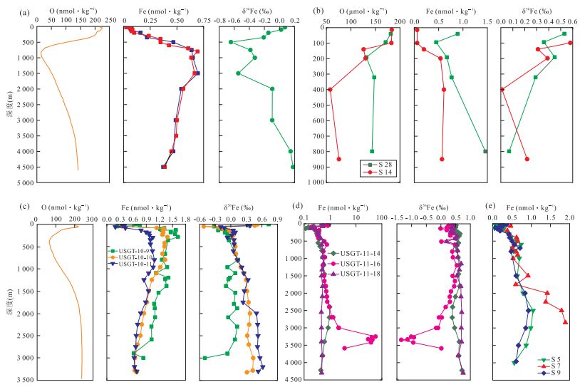
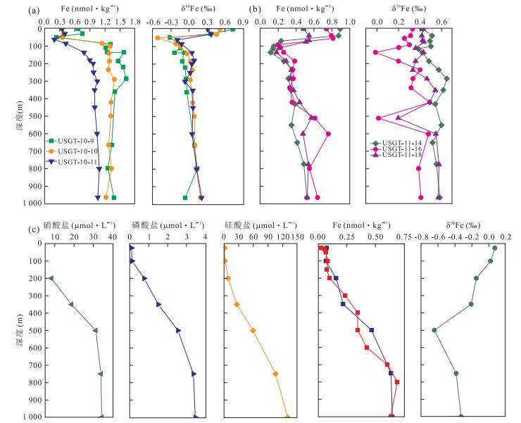
The isotopic compositions of Fe in the seawater profiles are remarkably heterogeneous. Dissolved Fe concentrations and Fe isotopic compositions in the seawater from the mid-ocean ridge and coastal zone of the Atlantic Ocean, the East Pacific and the West Pacific back-arc spreading centers were analyzed. In this paper, the dissolved Fe concentrations and Fe isotopic compositions in the seawater from surface layer, middle layer and deep sea are investigated, and the controlling factors on the ocean Fe cycle and the contribution of seafloor hydrothermal activity to seawater Fe isotopic composition are unveiled. Primary conclusions are as follows:(1) both the dissolved Fe concentrations and Fe isotopic compositions in the seawater profiles vary from region to region. The Fe isotopic compositions keep in line with dissolved oxygen concentration, but exhibit mirror image relationship with dissolved Fe concentrations; (2) the main controlling factors of dissolved Fe concentrations and Fe isotopic compositions in different seawater depths are different. Surface water is influenced by atmospheric dust and biological effects, which leads to heavier Fe isotopic composition, but it tends to become lighter when affected by the river. The deep-sea water is mainly influenced by sediment and seafloor hydrothermal activity. The non-reducing dissolved Fe from the sediment leads to heavier Fe isotopic composition, while mid-ocean-ridge hydrothermal fluid contributes to lighter Fe isotopic composition; (3) the estimated global hydrothermal fluid contribution to seawater Fe budget reaches to about 5.5% based on the relationship between dissolved Fe isotope and its flux, when put the minimum value of hydrothermal dissolved Fe (0.5 Gmol/a) as mid-ocean-ridge hydrothermal inputs to the global ocean. Owing to the fact that the dissolved Fe isotope flux from hydrothermal fluid is more than 0.5 Gmol/a, the contribution of the dissolved Fe to seawater may greatly exceed the previous estimation (6.0%).
The isotopic compositions of Fe in the seawater profiles are remarkably heterogeneous. Dissolved Fe concentrations and Fe isotopic compositions in the seawater from the mid-ocean ridge and coastal zone of the Atlantic Ocean, the East Pacific and the West Pacific back-arc spreading centers were analyzed. In this paper, the dissolved Fe concentrations and Fe isotopic compositions in the seawater from surface layer, middle layer and deep sea are investigated, and the controlling factors on the ocean Fe cycle and the contribution of seafloor hydrothermal activity to seawater Fe isotopic composition are unveiled. Primary conclusions are as follows:(1) both the dissolved Fe concentrations and Fe isotopic compositions in the seawater profiles vary from region to region. The Fe isotopic compositions keep in line with dissolved oxygen concentration, but exhibit mirror image relationship with dissolved Fe concentrations; (2) the main controlling factors of dissolved Fe concentrations and Fe isotopic compositions in different seawater depths are different. Surface water is influenced by atmospheric dust and biological effects, which leads to heavier Fe isotopic composition, but it tends to become lighter when affected by the river. The deep-sea water is mainly influenced by sediment and seafloor hydrothermal activity. The non-reducing dissolved Fe from the sediment leads to heavier Fe isotopic composition, while mid-ocean-ridge hydrothermal fluid contributes to lighter Fe isotopic composition; (3) the estimated global hydrothermal fluid contribution to seawater Fe budget reaches to about 5.5% based on the relationship between dissolved Fe isotope and its flux, when put the minimum value of hydrothermal dissolved Fe (0.5 Gmol/a) as mid-ocean-ridge hydrothermal inputs to the global ocean. Owing to the fact that the dissolved Fe isotope flux from hydrothermal fluid is more than 0.5 Gmol/a, the contribution of the dissolved Fe to seawater may greatly exceed the previous estimation (6.0%).


2017, 42(9): 1531-1540.
doi: 10.3799/dqkx.2017.503
Abstract:
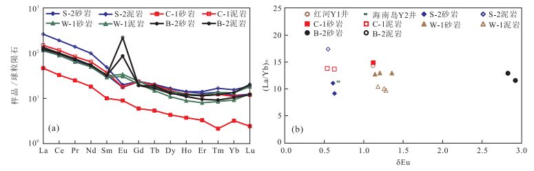
The submarine fans, which exist in the west area of Qiongdongnan basin of continental shelf in northern of the South China Sea, are the main area of gas exploration. Based on the analyses of the rock types, light and heavy mineral characteristics and geochemical characteristics, the research on estimating those fans provenances is more practical to the reservoir evaluation and prediction of the petroleum exploration. The study shows that the lithology is composed mainly of fine sandstones with minor amounts of siltstone, medium and coarse sandstones; the rock types are quartz sandstone, debris-quartz sandstone and feldspar-debris sandstone; the heavy mineral assemblages are magnetite, zircon, tourmaline and leucoxene. Compared with sandstone, the content of SiO2 in the mudstone is lower, while the total content of the rare earth elements is obviously higher because of the high ferromagnesian and clay mineral in mudstone samples. It is implied that the source material were rich in quartz, poor in feldspar and containing a large number of clay minerals, mainly quartz sediment and partial intermediate igneous rocks, mainly recycled sediments, whose source regions have experienced low to moderate weathering.
The submarine fans, which exist in the west area of Qiongdongnan basin of continental shelf in northern of the South China Sea, are the main area of gas exploration. Based on the analyses of the rock types, light and heavy mineral characteristics and geochemical characteristics, the research on estimating those fans provenances is more practical to the reservoir evaluation and prediction of the petroleum exploration. The study shows that the lithology is composed mainly of fine sandstones with minor amounts of siltstone, medium and coarse sandstones; the rock types are quartz sandstone, debris-quartz sandstone and feldspar-debris sandstone; the heavy mineral assemblages are magnetite, zircon, tourmaline and leucoxene. Compared with sandstone, the content of SiO2 in the mudstone is lower, while the total content of the rare earth elements is obviously higher because of the high ferromagnesian and clay mineral in mudstone samples. It is implied that the source material were rich in quartz, poor in feldspar and containing a large number of clay minerals, mainly quartz sediment and partial intermediate igneous rocks, mainly recycled sediments, whose source regions have experienced low to moderate weathering.


2017, 42(9): 1541-1548.
doi: 10.3799/dqkx.2017.520
Abstract:
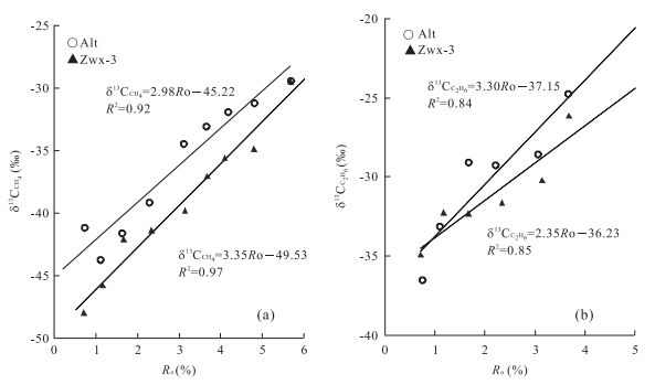
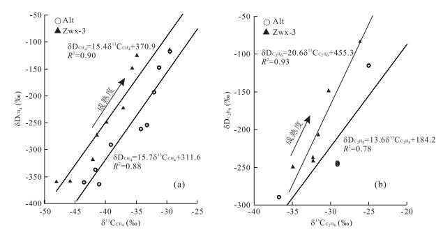
The study of coalbed methane (CBM) can provide scientific basis for coalbed methane exploration and development. However, the hydrogen and carbon isotopic compositions of CBM are affected by many factors. Previous studies were mainly concerned with the influence of the properties of gas-forming parent material and maturity on the hydrogen and carbon isotopic compositions of CBM. The influence of formation environment of gas-forming parent material on the isotopic compositions of thermogenic CBM is still unclear. Closed-system isothermal pyrolysis experiments were performed on herbaceous marsh peats derived from high latitude area with cold and dry climates and low latitude area with tropical moist climate. The hydrogen and carbon isotopic compositions and their differences of the hydrocarbon gases (methane, ethane and propane) generated during the pyrolysis of the samples were studied. The results show that the hydrocarbon gases generated from the herbaceous swamp peat in high latitude area had lighter hydrogen and heavier carbon isotopic compositions compared with those in low latitude area. At pyrolysis intervals from peat to vitrinite reflectance values (Ro) of 2.5%, 3.5% and 5.5%, the differences in the average δD values between the samples in high latitude and low latitude areas were from -17‰ to -10‰ for methane, -32‰ to -28‰ for ethane and -25‰ to -17‰ for propane, and in the average δ13C values between them were 2.9‰ to 3.6‰ for methane and 0.9‰ to 1.1‰ for ethane, respectively. The differences should result from the influence of climatic environment on hydrogen and carbon isotopic compositions of coal-forming original material. The relationship between Ro values and the hydrogen and carbon isotopic compositions of gases generated by coal-forming organic matter under different climatic environments as well as the hydrogen or carbon isotopic relationships of methane and ethane were established. These results may provide a basis for studying on the genesis of coalbed gas formed by coal-forming material under different climatic environments.
The study of coalbed methane (CBM) can provide scientific basis for coalbed methane exploration and development. However, the hydrogen and carbon isotopic compositions of CBM are affected by many factors. Previous studies were mainly concerned with the influence of the properties of gas-forming parent material and maturity on the hydrogen and carbon isotopic compositions of CBM. The influence of formation environment of gas-forming parent material on the isotopic compositions of thermogenic CBM is still unclear. Closed-system isothermal pyrolysis experiments were performed on herbaceous marsh peats derived from high latitude area with cold and dry climates and low latitude area with tropical moist climate. The hydrogen and carbon isotopic compositions and their differences of the hydrocarbon gases (methane, ethane and propane) generated during the pyrolysis of the samples were studied. The results show that the hydrocarbon gases generated from the herbaceous swamp peat in high latitude area had lighter hydrogen and heavier carbon isotopic compositions compared with those in low latitude area. At pyrolysis intervals from peat to vitrinite reflectance values (Ro) of 2.5%, 3.5% and 5.5%, the differences in the average δD values between the samples in high latitude and low latitude areas were from -17‰ to -10‰ for methane, -32‰ to -28‰ for ethane and -25‰ to -17‰ for propane, and in the average δ13C values between them were 2.9‰ to 3.6‰ for methane and 0.9‰ to 1.1‰ for ethane, respectively. The differences should result from the influence of climatic environment on hydrogen and carbon isotopic compositions of coal-forming original material. The relationship between Ro values and the hydrogen and carbon isotopic compositions of gases generated by coal-forming organic matter under different climatic environments as well as the hydrogen or carbon isotopic relationships of methane and ethane were established. These results may provide a basis for studying on the genesis of coalbed gas formed by coal-forming material under different climatic environments.


2017, 42(9): 1549-1564.
doi: 10.3799/dqkx.2017.110
Abstract:
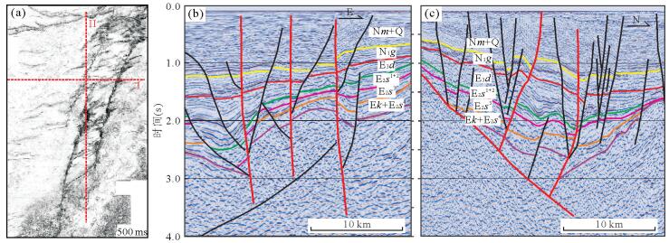
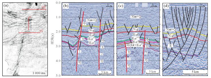
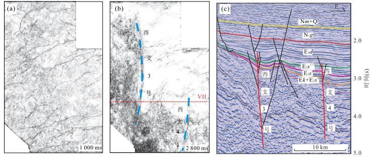
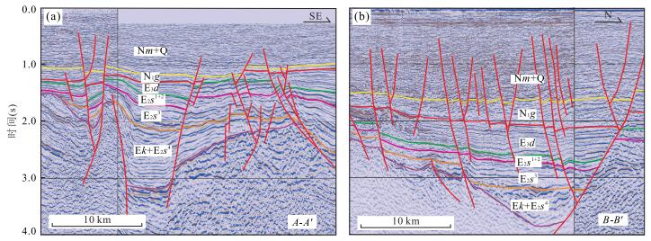
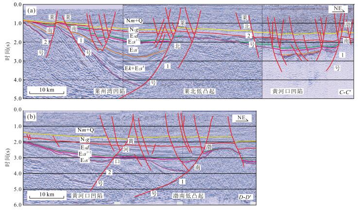
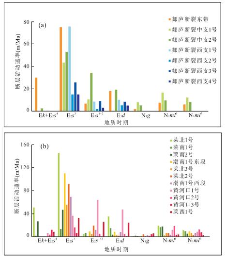
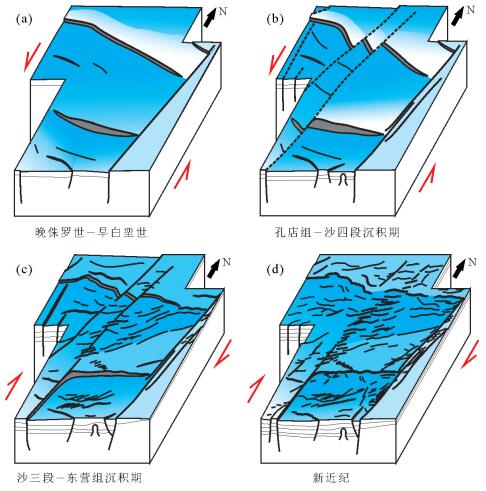
Tan-Lu fault zone in the south area of Bohai Sea has a good prospect for oil and gas exploration. However, due to its complicated structural features, the understanding of hydrocarbon accumulation conditions, main controlling factors and enrichment regularity is not clear at present. On the basis of the previous studies, 3D seismic data and geological information, the structural characteristics and spatiotemporal differences of Tan-Lu fault zone in the south area of Bohai Sea and the control of the development and evolution of Tan-Lu fault zone on the basin structure are studied in this paper. The results show that Tan-Lu fault zone in the south area of Bohai Sea has three branches, each of which is composed of 2-4 faults presenting strike-slip characteristics. The strike-slip strength gradually weakens westward. From Paleogene to Early Eocene, Tan-Lu fault zone in the south area of Bohai Sea presented sinistral strike-slip characteristics. The eastern branch experienced intense strike-slip movement, whereas the middle and western branches moved slightly, and the NWW-trending extensional faults which developed in Mesozoic renewed. Basin in the south area of Bohai Sea shows as a half-graben with northern-faulted and southern-overlapped structural setting or a graben with both northern and southern faulted settings. From the Middle Eocene, Tan-Lu fault zone turned into dextral strike-slip movement. The three branches started to activate and showed both strike-slip and extensional properties. The intensity of fault activity gradually weakened from east to west. The middle branch divided the Huanghekou sag into two subsags. A series of secondary faults formed the broom-like structure combined with the main fault. From Neogene to Quaternary, Tan-Lu fault zone presented dextral strike-slip as well as extrusion movement in the study area and a large number of small-scale secondary faults have developed. The change of subduction direction and rate of Pacific plate and the variation of deep geodynamics mechanism induce the differences of the evolution process of three branches and their controlling effect on the basin structure. Since the strength of dextral strike-slip movement is less than that of sinistral strike-slip, the distribution of the structural units in the south area of Bohai Sea are still showing the sinistral strike-slip characteristic now.
Tan-Lu fault zone in the south area of Bohai Sea has a good prospect for oil and gas exploration. However, due to its complicated structural features, the understanding of hydrocarbon accumulation conditions, main controlling factors and enrichment regularity is not clear at present. On the basis of the previous studies, 3D seismic data and geological information, the structural characteristics and spatiotemporal differences of Tan-Lu fault zone in the south area of Bohai Sea and the control of the development and evolution of Tan-Lu fault zone on the basin structure are studied in this paper. The results show that Tan-Lu fault zone in the south area of Bohai Sea has three branches, each of which is composed of 2-4 faults presenting strike-slip characteristics. The strike-slip strength gradually weakens westward. From Paleogene to Early Eocene, Tan-Lu fault zone in the south area of Bohai Sea presented sinistral strike-slip characteristics. The eastern branch experienced intense strike-slip movement, whereas the middle and western branches moved slightly, and the NWW-trending extensional faults which developed in Mesozoic renewed. Basin in the south area of Bohai Sea shows as a half-graben with northern-faulted and southern-overlapped structural setting or a graben with both northern and southern faulted settings. From the Middle Eocene, Tan-Lu fault zone turned into dextral strike-slip movement. The three branches started to activate and showed both strike-slip and extensional properties. The intensity of fault activity gradually weakened from east to west. The middle branch divided the Huanghekou sag into two subsags. A series of secondary faults formed the broom-like structure combined with the main fault. From Neogene to Quaternary, Tan-Lu fault zone presented dextral strike-slip as well as extrusion movement in the study area and a large number of small-scale secondary faults have developed. The change of subduction direction and rate of Pacific plate and the variation of deep geodynamics mechanism induce the differences of the evolution process of three branches and their controlling effect on the basin structure. Since the strength of dextral strike-slip movement is less than that of sinistral strike-slip, the distribution of the structural units in the south area of Bohai Sea are still showing the sinistral strike-slip characteristic now.


2017, 42(9): 1565-1577.
doi: 10.3799/dqkx.2017.1181
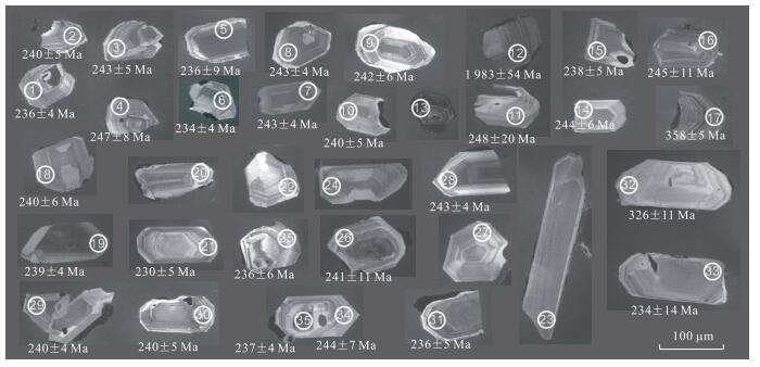
Abstract:
The main controversies of Triassic Yanchang Formation in Ordos basin are focused on the following two aspects:whether the age of Yanchang Formation covers the Middle Triassic; the confirmation of stratigraphic boundary between Middle and Upper Triassic, especially the attribution of the Chang 73. Therefore, the tuff samples of H2-2 and H2-1 were taken from the bottom and upper-middle Chang 73 in H2 Well respectively. The chronological (zircon LA-ICP-MS U-Pb) and petrographical features of H2-2 and the petrographical and geochemical features of H2-1 are researched. The results indicate that the zircons in H2-2 belong to magmatic zircons and their weighted average 206Pb/238U ages are 239.8±2.0 Ma, which is classified into Middle Triassic Ladinian age and corresponds to Episode Ⅰ of Indosinian Movement. The tuff of Chang 73 is derived from continental granite, in accordance with the tectonic setting of West Qinling region. Combined with previous results, it is thought that Yanchang Formation spans the Middle and Late Triassic epochs. Chang 73 belongs the 2nd member of Yanchang Formation and its top surface (i.e. top surface of Zhangjiatan shale) is the boundary between Middle and Upper Triassic. The magma activities in Episode Ⅰ of Indosinian Movement brought about the Chang 7 oil group, the tuff and other event sediments in Ordos basin. And the granitic magma activities in West Qinling region are coupled with the tuff of Chang 73 in distribution thickness, ages, magma features, and tectonic environment. It is likely that the tuff of Chang 73 derives from the magma activities in West Qinling region.
The main controversies of Triassic Yanchang Formation in Ordos basin are focused on the following two aspects:whether the age of Yanchang Formation covers the Middle Triassic; the confirmation of stratigraphic boundary between Middle and Upper Triassic, especially the attribution of the Chang 73. Therefore, the tuff samples of H2-2 and H2-1 were taken from the bottom and upper-middle Chang 73 in H2 Well respectively. The chronological (zircon LA-ICP-MS U-Pb) and petrographical features of H2-2 and the petrographical and geochemical features of H2-1 are researched. The results indicate that the zircons in H2-2 belong to magmatic zircons and their weighted average 206Pb/238U ages are 239.8±2.0 Ma, which is classified into Middle Triassic Ladinian age and corresponds to Episode Ⅰ of Indosinian Movement. The tuff of Chang 73 is derived from continental granite, in accordance with the tectonic setting of West Qinling region. Combined with previous results, it is thought that Yanchang Formation spans the Middle and Late Triassic epochs. Chang 73 belongs the 2nd member of Yanchang Formation and its top surface (i.e. top surface of Zhangjiatan shale) is the boundary between Middle and Upper Triassic. The magma activities in Episode Ⅰ of Indosinian Movement brought about the Chang 7 oil group, the tuff and other event sediments in Ordos basin. And the granitic magma activities in West Qinling region are coupled with the tuff of Chang 73 in distribution thickness, ages, magma features, and tectonic environment. It is likely that the tuff of Chang 73 derives from the magma activities in West Qinling region.


2017, 42(9): 1578-1589.
doi: 10.3799/dqkx.2017.504
Abstract:
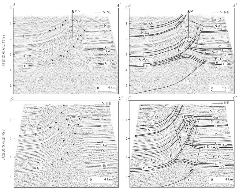
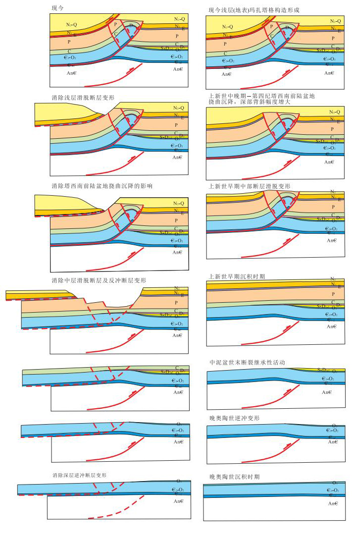
The evolution history of the Mazhatage fault belt is important for understanding the tectonic evolution and petroleum accumulation history of the Bachu uplift and Maigaiti slope in the Tarim basin. Based on detailed interpretation of the latest seismic data, the deformation structure and history of the Mazhatage fault belt are analyzed in this article. It is suggested that deformation of the Mazhatage fault belt could be divided into upper, middle and lower structures, formed at different times. Lateral variation of the Mazhatage mainly is reflected at its middle structure. The displacement of the thrust fault and its back thrusts that control the middle structure increased from east to west, led to the denudation at the core of fold also increased westwardly. The later deformation did not break the deep anticlinal trap. Thus, the Cambrian dolomite under the salt layer of deep anticline is a beneficial direction for oil-gas exploration in the Mazhatage fault area.
The evolution history of the Mazhatage fault belt is important for understanding the tectonic evolution and petroleum accumulation history of the Bachu uplift and Maigaiti slope in the Tarim basin. Based on detailed interpretation of the latest seismic data, the deformation structure and history of the Mazhatage fault belt are analyzed in this article. It is suggested that deformation of the Mazhatage fault belt could be divided into upper, middle and lower structures, formed at different times. Lateral variation of the Mazhatage mainly is reflected at its middle structure. The displacement of the thrust fault and its back thrusts that control the middle structure increased from east to west, led to the denudation at the core of fold also increased westwardly. The later deformation did not break the deep anticlinal trap. Thus, the Cambrian dolomite under the salt layer of deep anticline is a beneficial direction for oil-gas exploration in the Mazhatage fault area.


2017, 42(9): 1590-1598.
doi: 10.3799/dqkx.2017.514
Abstract:
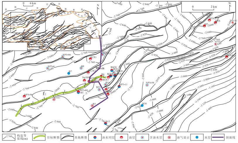
The failure degree of mudstone caprock was not considered in the previous study, and the study on the evolution history of the sealing characteristics of fractured mudstone caprock has not been reported in the literature, however, these problems are very important for oil and gas exploration in fault development area of petroliferous basin. On the basis of the study of the sealing mechanism and the closed evolution characteristics of fractured mudstone cap rock, by comparing the relative size of the fault contact thickness of the mudstone cap rock and the minimum fault contact thickness required for sealing oil and gas, the fractured mudstone cap rock sealling type is divided into 2 kinds, including non-fractured and fractured mudstone cover. And the mudstone cap rock sealing formation time, fault rock compaction time and sealing capacity formation time were determined by recovering the ancient displacement pressure of mudstone cap rock and fault rock. A restoration method of the closed evolution history of fractured mudstone cap rock is established, then it was applied on the restoration of closed evolution history of the fractured mudstone cap rocks damaged by f2 fault of Ed2, Nanpu 5 structure, Bohai Bay basin. The results show that fault f2 did not destroy the Ed2 mudstone cap rock sealing ability in L1, L3, L4, L5, L6, L7 and L9 test line, and is still mudstone cap rock sealling of Ed2, its closed evolution has experienced non-closed and closed phases. At present, it has strong sealing ability. The Ed2 mudstone cap rock sealing in L2 and L8 test lines was destroyed by fault f2, its sealing ability comes from f2 fault rock, the evolution of its sealing ability has experienced 3 stages:compaction period not closure, diagenetic period not closure and diagenetic period closure. At present, it has a strong ability of closure, which is favorable for the accumulation and preservation of oil and gas in the reservoir under the mudstone caprock of Ed2. The prediction results are consistent with the discovered oil and gas distribution in the reservoir under the Ed2 mudstone cap rock, which shows this method is feasible to restore the closed evolution history of mudstone cap rock.
The failure degree of mudstone caprock was not considered in the previous study, and the study on the evolution history of the sealing characteristics of fractured mudstone caprock has not been reported in the literature, however, these problems are very important for oil and gas exploration in fault development area of petroliferous basin. On the basis of the study of the sealing mechanism and the closed evolution characteristics of fractured mudstone cap rock, by comparing the relative size of the fault contact thickness of the mudstone cap rock and the minimum fault contact thickness required for sealing oil and gas, the fractured mudstone cap rock sealling type is divided into 2 kinds, including non-fractured and fractured mudstone cover. And the mudstone cap rock sealing formation time, fault rock compaction time and sealing capacity formation time were determined by recovering the ancient displacement pressure of mudstone cap rock and fault rock. A restoration method of the closed evolution history of fractured mudstone cap rock is established, then it was applied on the restoration of closed evolution history of the fractured mudstone cap rocks damaged by f2 fault of Ed2, Nanpu 5 structure, Bohai Bay basin. The results show that fault f2 did not destroy the Ed2 mudstone cap rock sealing ability in L1, L3, L4, L5, L6, L7 and L9 test line, and is still mudstone cap rock sealling of Ed2, its closed evolution has experienced non-closed and closed phases. At present, it has strong sealing ability. The Ed2 mudstone cap rock sealing in L2 and L8 test lines was destroyed by fault f2, its sealing ability comes from f2 fault rock, the evolution of its sealing ability has experienced 3 stages:compaction period not closure, diagenetic period not closure and diagenetic period closure. At present, it has a strong ability of closure, which is favorable for the accumulation and preservation of oil and gas in the reservoir under the mudstone caprock of Ed2. The prediction results are consistent with the discovered oil and gas distribution in the reservoir under the Ed2 mudstone cap rock, which shows this method is feasible to restore the closed evolution history of mudstone cap rock.


2017, 42(9): 1599-1607.
doi: 10.3799/dqkx.2017.528
Abstract:
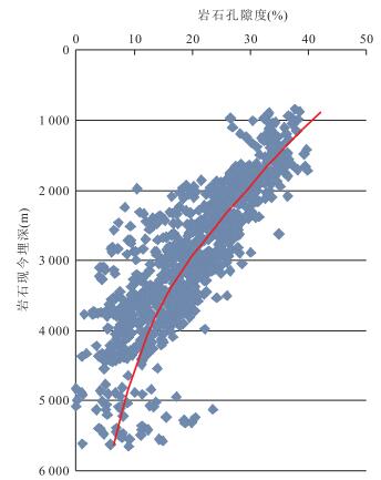
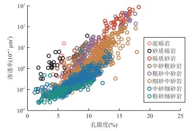
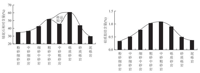
In the background of low-permeability reservoir in Huagang Formation, Xihu depression, high-quality reservoir is often associated with the enrichment of chlorite and siliceous cement, which is inconsistent with the view that chlorite can restrain siliceous cement. The classification and formation of chlorite were analyzed by X-ray, casting thin section, fluid inclusion test and scanning electron microscopy with spectrum. And the influence of chlorite on siliceous cement was studied through the comparison of the distribution of chlorite and siliceous cement in different reservoirs and the evolution of formation condition and reservoir quality. The results show that chlorite presents as pore-linking and pore-filling occurrences. Pore-linking chlorite is formed by the recrystallization of early clay coating or crystallization of pore fluid, and pore-filling chlorite is closely related to the dissolution of volcanic debris and feldspar. Chlorite and siliceous cement are both abundant in coarse reservoir (except sandy conglomerate and muddy gravel reservoir). Chlorite can hinder siliceous cement effectively during shallow burial and low geotemperature, and siliceous cement only grows above discontinuity chlorite or broken particle as isolated columnar quartz. Siliceous cement cannot be prevented during deeply buried and high geotemperature, and it develops as quartz overgrowth. The pores of coarse reservoir are more abundant than fine reservoir and conglomerate and muddy gravel reservoir, and the pores provide necessary space for quartz overgrowth, which is the main reason why chlorite and siliceous cement are both plentiful in high-quality coarse reservoir.
In the background of low-permeability reservoir in Huagang Formation, Xihu depression, high-quality reservoir is often associated with the enrichment of chlorite and siliceous cement, which is inconsistent with the view that chlorite can restrain siliceous cement. The classification and formation of chlorite were analyzed by X-ray, casting thin section, fluid inclusion test and scanning electron microscopy with spectrum. And the influence of chlorite on siliceous cement was studied through the comparison of the distribution of chlorite and siliceous cement in different reservoirs and the evolution of formation condition and reservoir quality. The results show that chlorite presents as pore-linking and pore-filling occurrences. Pore-linking chlorite is formed by the recrystallization of early clay coating or crystallization of pore fluid, and pore-filling chlorite is closely related to the dissolution of volcanic debris and feldspar. Chlorite and siliceous cement are both abundant in coarse reservoir (except sandy conglomerate and muddy gravel reservoir). Chlorite can hinder siliceous cement effectively during shallow burial and low geotemperature, and siliceous cement only grows above discontinuity chlorite or broken particle as isolated columnar quartz. Siliceous cement cannot be prevented during deeply buried and high geotemperature, and it develops as quartz overgrowth. The pores of coarse reservoir are more abundant than fine reservoir and conglomerate and muddy gravel reservoir, and the pores provide necessary space for quartz overgrowth, which is the main reason why chlorite and siliceous cement are both plentiful in high-quality coarse reservoir.


2017, 42(9): 1608-1622.
doi: 10.3799/dqkx.2017.531
Abstract:
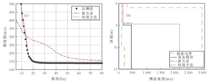
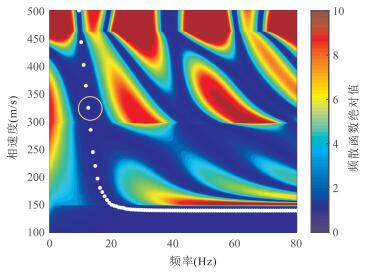
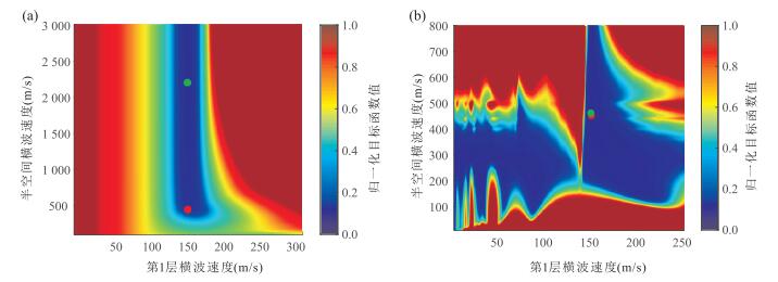
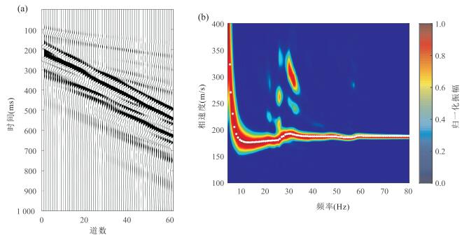
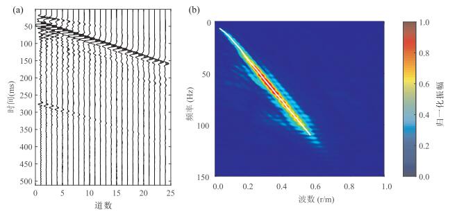
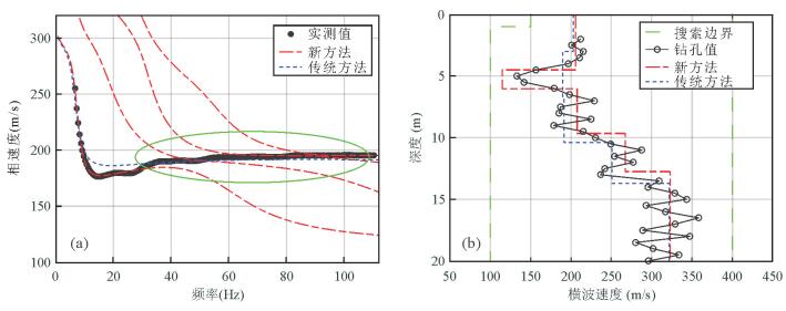
Inversion of the Rayleigh wave dispersion curve can effectively obtain the shear wave velocity and stratum thickness. And the classical inversion of multimode Rayleigh wave dispersion curve requires correct mode identification. However, there may be "mode-kissing" and "mode-jumping" phenomena in the Rayleigh waves when the stratum contains complex structures such as low-velocity soft intercalations or high-speed stiff sandwich layers. These phenomena can easily lead to mode misidentification, and lead to wrong inversion results. At the same time, the classical dispersion curve inversion method needs to seek the roots, which leads to that the nonlinear inversion of Rayleigh wave is slow and the computation time is long. In view of these, the classical Haskell-Thomson dispersion curve forward modeling algorithm is improved, and a novel and effective misfit function is proposed. The misfit function is directly used to fit the dispersion function surface shape of the iterative updating model by using the measured dispersion curve. It is not necessary to assign the multimode dispersion data to a specific mode, which can effectively avoid the mode misidentification in the inversion of multimode Rayleigh wave dispersion curve. And the misfit function does not require the seeking root operation, thus greatly accelerating the nonlinear inversion speed. In this paper, based on the particle swarm optimization algorithm, three theoretical geological models and a certain roadbed test data often encountered in practical work are used to calculate the theoretical model and analyze the example. And the validity and practicability of the new method of Rayleigh wave multimode dispersion curve inversion are verified.
Inversion of the Rayleigh wave dispersion curve can effectively obtain the shear wave velocity and stratum thickness. And the classical inversion of multimode Rayleigh wave dispersion curve requires correct mode identification. However, there may be "mode-kissing" and "mode-jumping" phenomena in the Rayleigh waves when the stratum contains complex structures such as low-velocity soft intercalations or high-speed stiff sandwich layers. These phenomena can easily lead to mode misidentification, and lead to wrong inversion results. At the same time, the classical dispersion curve inversion method needs to seek the roots, which leads to that the nonlinear inversion of Rayleigh wave is slow and the computation time is long. In view of these, the classical Haskell-Thomson dispersion curve forward modeling algorithm is improved, and a novel and effective misfit function is proposed. The misfit function is directly used to fit the dispersion function surface shape of the iterative updating model by using the measured dispersion curve. It is not necessary to assign the multimode dispersion data to a specific mode, which can effectively avoid the mode misidentification in the inversion of multimode Rayleigh wave dispersion curve. And the misfit function does not require the seeking root operation, thus greatly accelerating the nonlinear inversion speed. In this paper, based on the particle swarm optimization algorithm, three theoretical geological models and a certain roadbed test data often encountered in practical work are used to calculate the theoretical model and analyze the example. And the validity and practicability of the new method of Rayleigh wave multimode dispersion curve inversion are verified.


2017, 42(9): 1623-1636.
doi: 10.3799/dqkx.2017.526
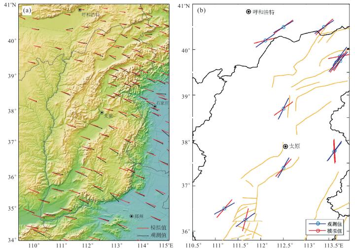
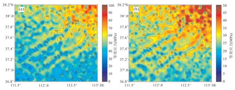
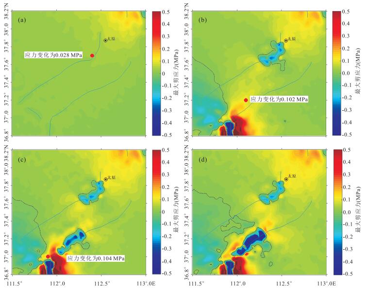
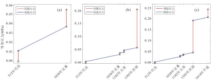
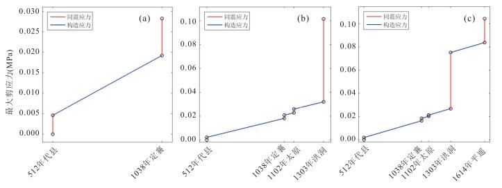
Abstract:
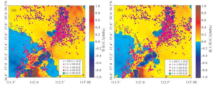
In recent years, although no strong earthquakes occurred in Taiyuan basin, small earthquakes were very active. However, the research on the distribution and evolution of tectonic stress field in Taiyuan basin is very little. The 3-D viscoelastic finite element model of Shanxi area including Taiyuan basin is built by applying the finite element numerical method in this paper. In addition, the difference of regional geological structure, the main active fault zone, irregular topography and layered lithosphere structure synthetically, as well as the seismic velocity structure of the crust and mantle, are considered when building the model. Moreover, the present tectonic background stress field in the research area is reconstructed by the constraint of the observed values of GPS and direction of the maximum principal compressive stress. On these bases, the historical strong earthquake sequences with M ≥ 6 in Taiyuan basin and with M ≥ 7 in Shanxi seismic zone since AD 512 are simulated, respectively. The calculated results illustrate that the three historical strong earthquakes in Taiyuan basin are all located in the area where stress field increased more than 0.01 MPa, and the spatial distribution of small earthquakes in recent years has a good correlation with the present stress field change greater than 0.01 MPa. The results show that the historical strong earthquake sequence in Shanxi seismic zone and long-term tectonic stress loading both promoted the three historical strong earthquakes in Taiyuan basin. The present seismic activity of Taiyuan basin is obviously controlled by the current stress level in the area.
In recent years, although no strong earthquakes occurred in Taiyuan basin, small earthquakes were very active. However, the research on the distribution and evolution of tectonic stress field in Taiyuan basin is very little. The 3-D viscoelastic finite element model of Shanxi area including Taiyuan basin is built by applying the finite element numerical method in this paper. In addition, the difference of regional geological structure, the main active fault zone, irregular topography and layered lithosphere structure synthetically, as well as the seismic velocity structure of the crust and mantle, are considered when building the model. Moreover, the present tectonic background stress field in the research area is reconstructed by the constraint of the observed values of GPS and direction of the maximum principal compressive stress. On these bases, the historical strong earthquake sequences with M ≥ 6 in Taiyuan basin and with M ≥ 7 in Shanxi seismic zone since AD 512 are simulated, respectively. The calculated results illustrate that the three historical strong earthquakes in Taiyuan basin are all located in the area where stress field increased more than 0.01 MPa, and the spatial distribution of small earthquakes in recent years has a good correlation with the present stress field change greater than 0.01 MPa. The results show that the historical strong earthquake sequence in Shanxi seismic zone and long-term tectonic stress loading both promoted the three historical strong earthquakes in Taiyuan basin. The present seismic activity of Taiyuan basin is obviously controlled by the current stress level in the area.


2017, 42(9): 1637-1646.
doi: 10.3799/dqkx.2017.112
Abstract:
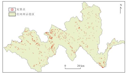
The researching on geo-hazards risk indicator model has been the hot spot of related departments and scholars, indicating reliability problems have always been a research difficult point and technology core.Honghe prefecture is one of the most serious areas of geo-hazards in Yunnan Province, but little research about geo-hazards risk indicator has been done in this region.Based on the information value method, a geo-hazards indicator model about Honghe prefecture was established considering the rainfall-induced factors, hazard-formative environment of this region which is the first time using 100 m×100 m warning unit. Through the verification of historical geological hazard happening, the accuracy rate of warning can highly reach 81.8%. The result indicated that it's workable to integrate meteorological factors and geological environment factors into the indicator model which can be an effective way to improve the level of geo-hazard warning.
The researching on geo-hazards risk indicator model has been the hot spot of related departments and scholars, indicating reliability problems have always been a research difficult point and technology core.Honghe prefecture is one of the most serious areas of geo-hazards in Yunnan Province, but little research about geo-hazards risk indicator has been done in this region.Based on the information value method, a geo-hazards indicator model about Honghe prefecture was established considering the rainfall-induced factors, hazard-formative environment of this region which is the first time using 100 m×100 m warning unit. Through the verification of historical geological hazard happening, the accuracy rate of warning can highly reach 81.8%. The result indicated that it's workable to integrate meteorological factors and geological environment factors into the indicator model which can be an effective way to improve the level of geo-hazard warning.