2018 Vol. 43, No. 10
Display Method:
 PDF 353KB
2018, 43(10): 3337-3361.
doi: 10.3799/dqkx.2018.330
Abstract:
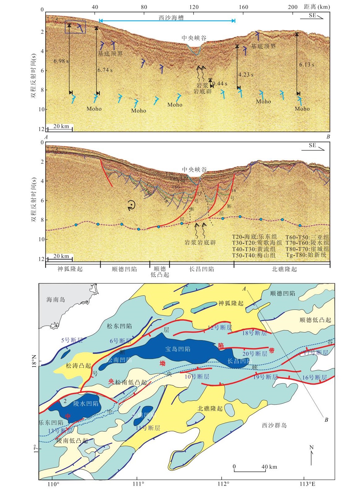
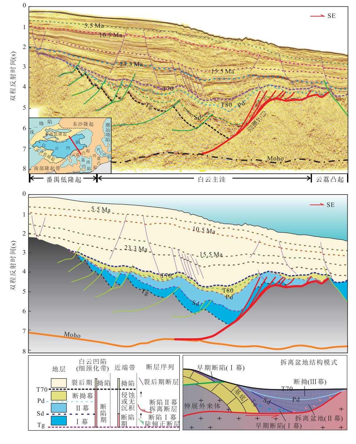
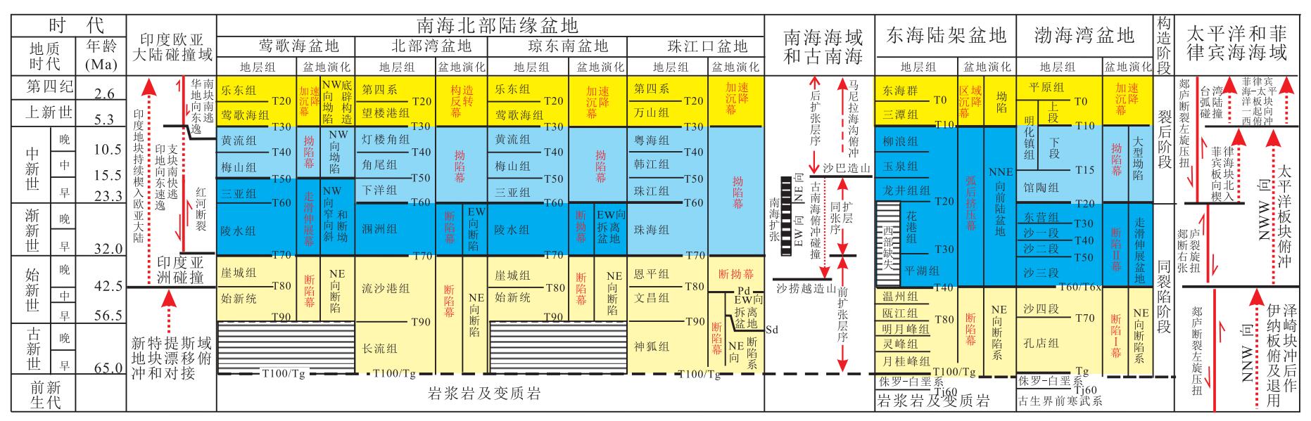
More than 10 Cenozoic oil-rich sedimentary basins have been developed in the offshore area of China. The differences and similarities in their evolution process and dynamic background need to be systematically summarized with unified research ideas and methods. Based on abundant geological and geophysical data in petroleum exploration and production in the offshore basins, this paper analyzes the tectono-stratigraphic framework of the Cenozoic basins located in the Bohai Sea, the East China Sea and the South China Sea. First, we further clarify the obliquely pull-apart evolution stage of the Bohai Bay Basin by demonstrating the regional strike-slip fault system dominated the basin development. After presenting the importance of regional compression on the evolution of the East China Sea Basin, we sub-divide an evolution stage of the retroarc foreland basin. As for the northern South China Sea, we discover large detachment faults and their controlling detachment basins in the deepwater areas; and thus propose that the large-scale detachment faulting is the main mechanism for the crustal thinning, mantle exhumation and the formation of deepwater marginal basins. Our study reveals offshore basins in China had experienced an early-stage extension covering the whole region; then they entered into a differential tectonic evolution stage since Late Eocene. To be specific, the Bohai Sea experiences an evolution process of early rifting through an oblique strike-slip deformation, a thermal subsidence and finally a rapid subsidence. The East China Sea evolved from a rift basin to a retroarc foreland basin, then became a regional subsidence basin. While the South China Sea had a continuing extension evolution process of an early-rift basin, detachment basin, seafloor spreading with continental lithospheric breakup, and the present-day passive continental margin. The kinematics analysis of the regional plate tectonics suggests the global plate reorganization in Late Eocene resulted in the differential evolution of the offshore basins, before which the East China had mainly been under a "double-plate" dynamic system constructed by the interaction between the Eurasian plate and the Pacific plate. The subduction and retreat of the Pacific plate led to the back-arc extension on the continental margin and the formation of a massive Basin-Range type basin system in the eastern margin. After the reorganization, mainland China has been under the "multi-plate system" constructed by the Indian plate, the Eurasian plate, the Pacific plate and the Philippine sea plate. The India-Eurasia collision, the direction change of the Pacific plate subduction, and subduction and collision of the paleo South China Sea, the subduction of the wedge-shaped Philippine Sea plate and its westward migration and subduction with Pacific plate led to more complex plate motion processes and a multi-stage kinematical reorganization. These plate tectonic events caused the diversity of the offshore basin genesis and the differences of their tectonic evolution processes.
More than 10 Cenozoic oil-rich sedimentary basins have been developed in the offshore area of China. The differences and similarities in their evolution process and dynamic background need to be systematically summarized with unified research ideas and methods. Based on abundant geological and geophysical data in petroleum exploration and production in the offshore basins, this paper analyzes the tectono-stratigraphic framework of the Cenozoic basins located in the Bohai Sea, the East China Sea and the South China Sea. First, we further clarify the obliquely pull-apart evolution stage of the Bohai Bay Basin by demonstrating the regional strike-slip fault system dominated the basin development. After presenting the importance of regional compression on the evolution of the East China Sea Basin, we sub-divide an evolution stage of the retroarc foreland basin. As for the northern South China Sea, we discover large detachment faults and their controlling detachment basins in the deepwater areas; and thus propose that the large-scale detachment faulting is the main mechanism for the crustal thinning, mantle exhumation and the formation of deepwater marginal basins. Our study reveals offshore basins in China had experienced an early-stage extension covering the whole region; then they entered into a differential tectonic evolution stage since Late Eocene. To be specific, the Bohai Sea experiences an evolution process of early rifting through an oblique strike-slip deformation, a thermal subsidence and finally a rapid subsidence. The East China Sea evolved from a rift basin to a retroarc foreland basin, then became a regional subsidence basin. While the South China Sea had a continuing extension evolution process of an early-rift basin, detachment basin, seafloor spreading with continental lithospheric breakup, and the present-day passive continental margin. The kinematics analysis of the regional plate tectonics suggests the global plate reorganization in Late Eocene resulted in the differential evolution of the offshore basins, before which the East China had mainly been under a "double-plate" dynamic system constructed by the interaction between the Eurasian plate and the Pacific plate. The subduction and retreat of the Pacific plate led to the back-arc extension on the continental margin and the formation of a massive Basin-Range type basin system in the eastern margin. After the reorganization, mainland China has been under the "multi-plate system" constructed by the Indian plate, the Eurasian plate, the Pacific plate and the Philippine sea plate. The India-Eurasia collision, the direction change of the Pacific plate subduction, and subduction and collision of the paleo South China Sea, the subduction of the wedge-shaped Philippine Sea plate and its westward migration and subduction with Pacific plate led to more complex plate motion processes and a multi-stage kinematical reorganization. These plate tectonic events caused the diversity of the offshore basin genesis and the differences of their tectonic evolution processes.


2018, 43(10): 3373-3390.
doi: 10.3799/dqkx.2018.998
Abstract:
A new conception of magmatic system-transcrustal magmatic system(TMS) has been raised recently. This paper focuses on the TMS of Early Cretaceous (Qingshan stage) in Eastern Shandong. Based on the geological field work and the research results of igneous chronology, distribution of fault system, tectonics and geochemistry, we discuss the temporal and spatial evolution and distribution characteristics of different volcanic magmatism. Firstly, the TMS varies from silicic magmatic emplacement to basic magmatic intrusion and then to medium magmatic eruption. Secondly, the TMS owes different behaviors at different depths of crust:from deep to shallow, TMS behaves in the sequence of Batholith/Stock-Intrusions/Dike-volcanic edifice. Thirdly, the silicic batholith/stock is mainly distributed in old uplift zone, while the volcanic edifice is mainly distributed along the deep fault. The development of TMS indicates the structure characteristics of lithosphere in Qingshan stage:The nearly E-W distribution of the stock itself shows the fault system in upper crust is nearly E-W when the magma flows upward. While the distribution of all the batholiths/stocks is in the direction of NE-SW, indicating that the deep fault system is in the direction of NE-SW, which controls the regional tectonic evolution. In Early Cretaceous, the shallow fault system developed in Laiyang stage provided the channel for the TMS developed in Qingshan stage. In the development period of TMS, there was strong "thermal-upwelling, stretching and detachment" effect, which resulted in the basin framework in Qingshan stage. The calculated rate of granite uplift related to thermal-upwelling is slightly faster than 2.47-3.7 mm/a. The intense "thermal-upwelling, stretching and detachment" effect is the main dynamic mechanism of basin formation in Qingshan stage.
A new conception of magmatic system-transcrustal magmatic system(TMS) has been raised recently. This paper focuses on the TMS of Early Cretaceous (Qingshan stage) in Eastern Shandong. Based on the geological field work and the research results of igneous chronology, distribution of fault system, tectonics and geochemistry, we discuss the temporal and spatial evolution and distribution characteristics of different volcanic magmatism. Firstly, the TMS varies from silicic magmatic emplacement to basic magmatic intrusion and then to medium magmatic eruption. Secondly, the TMS owes different behaviors at different depths of crust:from deep to shallow, TMS behaves in the sequence of Batholith/Stock-Intrusions/Dike-volcanic edifice. Thirdly, the silicic batholith/stock is mainly distributed in old uplift zone, while the volcanic edifice is mainly distributed along the deep fault. The development of TMS indicates the structure characteristics of lithosphere in Qingshan stage:The nearly E-W distribution of the stock itself shows the fault system in upper crust is nearly E-W when the magma flows upward. While the distribution of all the batholiths/stocks is in the direction of NE-SW, indicating that the deep fault system is in the direction of NE-SW, which controls the regional tectonic evolution. In Early Cretaceous, the shallow fault system developed in Laiyang stage provided the channel for the TMS developed in Qingshan stage. In the development period of TMS, there was strong "thermal-upwelling, stretching and detachment" effect, which resulted in the basin framework in Qingshan stage. The calculated rate of granite uplift related to thermal-upwelling is slightly faster than 2.47-3.7 mm/a. The intense "thermal-upwelling, stretching and detachment" effect is the main dynamic mechanism of basin formation in Qingshan stage.


2018, 43(10): 3391-3398.
doi: 10.3799/dqkx.2017.606
Abstract:
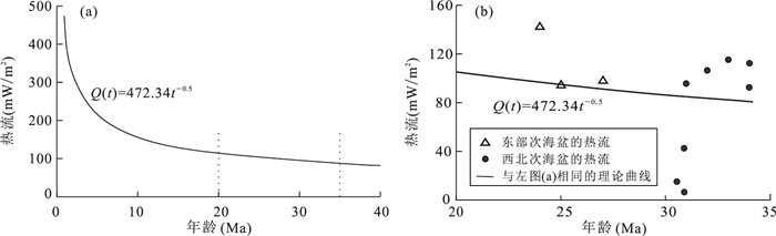
The Northwest sub-basin (NW sub-basin) is an important tectonic unit in the South China Sea. It is of great importance to reveal the geothermal characteristics of the NW sub-basin for the better understanding of thermal and thermal structures of the basins of South China Sea. We have collected a series of measured heat flow data along the OBS2006-1 seismic profile. This heat flow profile crosses four tectonic units, including the northern slope of the South China Sea, the NW sub-basin, the Zhongsha rise and the east sub-basin. With the seismic interpretation profile, this paper analyzes and studies in detail the heat flow characteristics. The results show that the average heat flow value is 104.5±9.9 mW/m2 in the NW sub-basin, and the average heat flow value in the northern part of the East sub-basin is 97±2.5 mW/m2, the change trend of the heat flow values is similar to that of the Moho depth, which manifests that the deep thermal state is controlled by the source of mantle heat. By studying the anomalies of heat flow, it is found that the temperature difference between the seabed surface sediments in adjacent sites is one of the basis for judging the degree and type of groundwater thermal cycling. With the latest ocean heat flow detection results, combined with regional geology and geophysical data, it is suggested that the formation of the NW sub-basin is similar to that of the Southwest sub-basin, but with relatively shorter history.
The Northwest sub-basin (NW sub-basin) is an important tectonic unit in the South China Sea. It is of great importance to reveal the geothermal characteristics of the NW sub-basin for the better understanding of thermal and thermal structures of the basins of South China Sea. We have collected a series of measured heat flow data along the OBS2006-1 seismic profile. This heat flow profile crosses four tectonic units, including the northern slope of the South China Sea, the NW sub-basin, the Zhongsha rise and the east sub-basin. With the seismic interpretation profile, this paper analyzes and studies in detail the heat flow characteristics. The results show that the average heat flow value is 104.5±9.9 mW/m2 in the NW sub-basin, and the average heat flow value in the northern part of the East sub-basin is 97±2.5 mW/m2, the change trend of the heat flow values is similar to that of the Moho depth, which manifests that the deep thermal state is controlled by the source of mantle heat. By studying the anomalies of heat flow, it is found that the temperature difference between the seabed surface sediments in adjacent sites is one of the basis for judging the degree and type of groundwater thermal cycling. With the latest ocean heat flow detection results, combined with regional geology and geophysical data, it is suggested that the formation of the NW sub-basin is similar to that of the Southwest sub-basin, but with relatively shorter history.


2018, 43(10): 3399-3406.
doi: 10.3799/dqkx.2018.317
Abstract:
The conventional magnetotelluric method is theoretically based upon definition of impedance tensor[ Z ] and the relationship between the electrical and magnetic components Ex, Ey, Hx, Hy, Hz of MT field, the main purpose of MT data processing is to obtain inpedance tensor, apparent resistivity, phase, tipper, skewness and other parameters. In this paper, we propose the definition of 6-elements tensor impedance and briefly describe its some characteristics and determination techniques in the comparison with the former impedance tensor[ Z ]. Furthermore, we explain the necessity of the proposed method and demonstrate its applicability by some field tests conducted in Democratic People's Republic of Korea.
The conventional magnetotelluric method is theoretically based upon definition of impedance tensor[ Z ] and the relationship between the electrical and magnetic components Ex, Ey, Hx, Hy, Hz of MT field, the main purpose of MT data processing is to obtain inpedance tensor, apparent resistivity, phase, tipper, skewness and other parameters. In this paper, we propose the definition of 6-elements tensor impedance and briefly describe its some characteristics and determination techniques in the comparison with the former impedance tensor[ Z ]. Furthermore, we explain the necessity of the proposed method and demonstrate its applicability by some field tests conducted in Democratic People's Republic of Korea.


2018, 43(10): 3407-3422.
doi: 10.3799/dqkx.2018.311
Abstract:
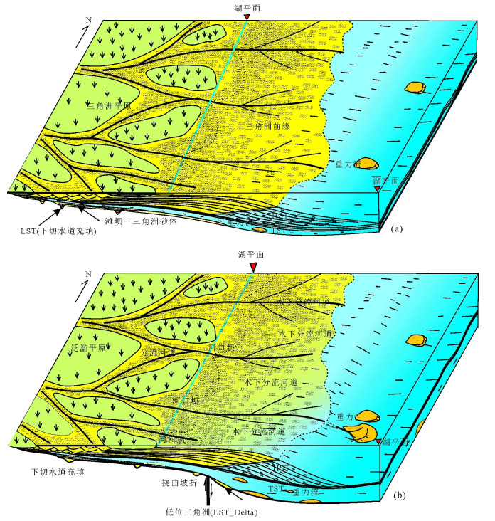
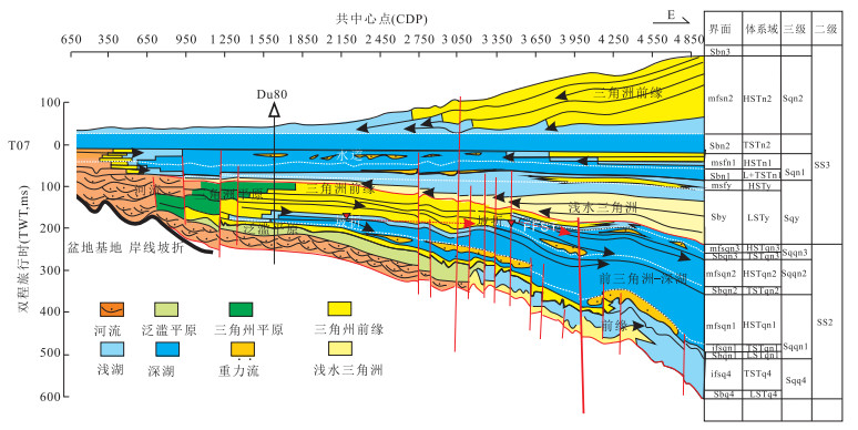
The South China Sea (SCS) Basin is the largest marginal sea basin with abundant petroleum resources on the continental shelf of Southeast Asia. However, there is a lack of research on the relationship between the development and sedimentary evolution of South China Sea continental slope belt and the tectonics and dynamic processes of the South China Sea Basin. Based on integrated analyses of seismic, well-logging and core data, the sequence architecture, depositional-geomorphological evolution and controlling processes of the continental slope in the Pearl River Mouth Basin of the northern SCS have been systematically documented. The sedimentary infill of the marginal sea basin can be divided into seven composite sequences (CS1-CS7) that are bounded by regional unconformities. Each of the composite sequences CS3 to CS7 (Upper Oligocene to Quaternary) comprises of generally a regional transgressive-regressive cycle. The CS3 to CS7 can be further divided into 20 sequences that are defined by local unconformities and correlative conformities. Depositional systems recognized in the continental slope deposits mainly include outer shelf to shelf-edge deltas, prodelta-slope fans, shelf-margin slope clinoforms, unidirectionally-migrating bottom current-gravity flow composite slope channels, large-scale incised slope valleys, muddy slope fans, slope slump-debris-flow complexes and large-scale soft-sediment deformed beds. They were arranged with distinguishing patterns in different sequences, forming various styles of depositional architectures. The study shows that the short-term sea level changes (sequences) are generally comparable with those of the Haq global sea level curve, whereas long-term sea level changes (composite sequences) were apparently controlled or enhanced by tectonic uplift and subsidence. The depositional evolution of the continental shelf margin can be divided into (1) the early post-rift seafloor spreading (breakup sequence), (2) the late post-rift seafloor spreading, and (3) the post-seafloor spreading tectonic-depositional stages. The thermal uplift, tectonic differential subsidence, post-rift thermal subsidence and the eastern collision after Pliocene are all regarded to have played an important role in the formation of major unconformities and regional transgressive-regressive cycles. The composite sequences (CS3 and CS4) developed during the Late Oligocene to Middle Miocene recorded the depositional successions of the continental slope formed from the beginning to the stopping of the seafloor spreading. The composite sequence (CS3) deposited during early post-rift stage is regarded as a breakup sequences. It is characterized by the development of large-scale continental shelf edge delta and prodelta slope fan systems. Climate change and monsoon strengthening may have enhanced the sediment supply during the Late Oligocene to Early Miocene and the Pleistocene, which may be responsible for the sufficient sediment supply for the development of large-scale continental shelf marginal delta systems during these periods. The shelf margin delta-shoreline clastic systems and the associated slope fan systems on the continental margin have proven to be the most important targets for oil and gas exploration.
The South China Sea (SCS) Basin is the largest marginal sea basin with abundant petroleum resources on the continental shelf of Southeast Asia. However, there is a lack of research on the relationship between the development and sedimentary evolution of South China Sea continental slope belt and the tectonics and dynamic processes of the South China Sea Basin. Based on integrated analyses of seismic, well-logging and core data, the sequence architecture, depositional-geomorphological evolution and controlling processes of the continental slope in the Pearl River Mouth Basin of the northern SCS have been systematically documented. The sedimentary infill of the marginal sea basin can be divided into seven composite sequences (CS1-CS7) that are bounded by regional unconformities. Each of the composite sequences CS3 to CS7 (Upper Oligocene to Quaternary) comprises of generally a regional transgressive-regressive cycle. The CS3 to CS7 can be further divided into 20 sequences that are defined by local unconformities and correlative conformities. Depositional systems recognized in the continental slope deposits mainly include outer shelf to shelf-edge deltas, prodelta-slope fans, shelf-margin slope clinoforms, unidirectionally-migrating bottom current-gravity flow composite slope channels, large-scale incised slope valleys, muddy slope fans, slope slump-debris-flow complexes and large-scale soft-sediment deformed beds. They were arranged with distinguishing patterns in different sequences, forming various styles of depositional architectures. The study shows that the short-term sea level changes (sequences) are generally comparable with those of the Haq global sea level curve, whereas long-term sea level changes (composite sequences) were apparently controlled or enhanced by tectonic uplift and subsidence. The depositional evolution of the continental shelf margin can be divided into (1) the early post-rift seafloor spreading (breakup sequence), (2) the late post-rift seafloor spreading, and (3) the post-seafloor spreading tectonic-depositional stages. The thermal uplift, tectonic differential subsidence, post-rift thermal subsidence and the eastern collision after Pliocene are all regarded to have played an important role in the formation of major unconformities and regional transgressive-regressive cycles. The composite sequences (CS3 and CS4) developed during the Late Oligocene to Middle Miocene recorded the depositional successions of the continental slope formed from the beginning to the stopping of the seafloor spreading. The composite sequence (CS3) deposited during early post-rift stage is regarded as a breakup sequences. It is characterized by the development of large-scale continental shelf edge delta and prodelta slope fan systems. Climate change and monsoon strengthening may have enhanced the sediment supply during the Late Oligocene to Early Miocene and the Pleistocene, which may be responsible for the sufficient sediment supply for the development of large-scale continental shelf marginal delta systems during these periods. The shelf margin delta-shoreline clastic systems and the associated slope fan systems on the continental margin have proven to be the most important targets for oil and gas exploration.


2018, 43(10): 3423-3444.
doi: 10.3799/dqkx.2018.329
Abstract:
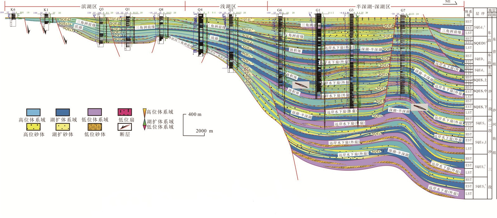
Continental gravity flow deposition is a research hotspot in the field of oil and gas exploration.The large scale gravity flow deposits (up to 1 700 km2) that developed in the Member 1 of Shahejie Formation (Paleogene) in the Binhai slope area in the Qikou Sag shows the sedimentary characters of multiple sediment sources, long distance and multi-fault transport, and preservation along the transfer path during the sedimentary processes. This study focus on the gravity flow deposits in the oil-rich Qikou Sag in Bohai Bay Basin. Under the sequence stratigraphy framework, the source-transport path-sink processes has been discussed. The aim of this study is to ① illuminate the formation of the multiple sources, the configuration relationship between different sources, and the origin of continuous sediment supply. ② analyze the controlling and evolution of the paleogeomorphology (fault-controlling steep slope and multi-step fault slope), sediment transport, the sedimentary develop mechanism in processes. ③ focus on the distributions, sedimentary patterns and space evolution of the large scale multi-stages gravity flow deposits. ④ discuss the formation mechanism and controlling factors of the gravity flow in Qikou Sag. The conclusions include:① the gravity flow was controlled by multiple sources. During the Member 1 of Shahejie Formation, the Binhai slope was supplied by sources from four different areas that include:Dashentang source from northern Yanshan Mountain, Chadian sources, Gegu and Xiaozhan sources from western Cangxian Uplift. The continuous sediment supply allows the large scale gravity flow to be formed in the lacustrine basin. ② the paleogeomorphology of the Member 1 of Shahejie Formation in the Qikou Sag is the complex of fault-controlling steep slope and multi-step fault slope. The fault-controlling steep slope is developed in the northern part of Binhai Slope, as the multi-step fault slope is mainly developed in the orientation of west to east in the west part of Binhai Slope. The fault zones play a role as the transport paths for the sediments and also provide accumulation space for the deposits to be preserved locally. The differential subsidence of the fault slope controls the distribution of the sedimentary systems. ③ the large scale gravity flow deposits that developed in the Member 1 of Shahejie Formation in the Binhai slope area in the Qikou Sag are mainly of gravity slump deposits, sandy debris flow deposits, muddy debris flow deposits, turbidities. The gravity flow deposits spread wide laterally and overlap onto each other vertically.
Continental gravity flow deposition is a research hotspot in the field of oil and gas exploration.The large scale gravity flow deposits (up to 1 700 km2) that developed in the Member 1 of Shahejie Formation (Paleogene) in the Binhai slope area in the Qikou Sag shows the sedimentary characters of multiple sediment sources, long distance and multi-fault transport, and preservation along the transfer path during the sedimentary processes. This study focus on the gravity flow deposits in the oil-rich Qikou Sag in Bohai Bay Basin. Under the sequence stratigraphy framework, the source-transport path-sink processes has been discussed. The aim of this study is to ① illuminate the formation of the multiple sources, the configuration relationship between different sources, and the origin of continuous sediment supply. ② analyze the controlling and evolution of the paleogeomorphology (fault-controlling steep slope and multi-step fault slope), sediment transport, the sedimentary develop mechanism in processes. ③ focus on the distributions, sedimentary patterns and space evolution of the large scale multi-stages gravity flow deposits. ④ discuss the formation mechanism and controlling factors of the gravity flow in Qikou Sag. The conclusions include:① the gravity flow was controlled by multiple sources. During the Member 1 of Shahejie Formation, the Binhai slope was supplied by sources from four different areas that include:Dashentang source from northern Yanshan Mountain, Chadian sources, Gegu and Xiaozhan sources from western Cangxian Uplift. The continuous sediment supply allows the large scale gravity flow to be formed in the lacustrine basin. ② the paleogeomorphology of the Member 1 of Shahejie Formation in the Qikou Sag is the complex of fault-controlling steep slope and multi-step fault slope. The fault-controlling steep slope is developed in the northern part of Binhai Slope, as the multi-step fault slope is mainly developed in the orientation of west to east in the west part of Binhai Slope. The fault zones play a role as the transport paths for the sediments and also provide accumulation space for the deposits to be preserved locally. The differential subsidence of the fault slope controls the distribution of the sedimentary systems. ③ the large scale gravity flow deposits that developed in the Member 1 of Shahejie Formation in the Binhai slope area in the Qikou Sag are mainly of gravity slump deposits, sandy debris flow deposits, muddy debris flow deposits, turbidities. The gravity flow deposits spread wide laterally and overlap onto each other vertically.


2018, 43(10): 3445-3461.
doi: 10.3799/dqkx.2018.222
Abstract:
The influence of basin tectonics and climate change on source and sink system, sedimentary system and sequence construction of post-rift basin still need to be studied.Songliang Basin (SB) is a Late Cretaceous large petroliferous post-rift basin. Based on tectonic-sequence analysis method, using log curves, observations of cores, 3D seismic data and logging data, two second-order sequences (SS) and seven third-order sequences are identified in the fourth member of Quantou Formation to seconder member of Nenjiang Formation in this study. Low accommodation sequences in the lower part of a SS and in dry climate, and high accommodation sequences (HAS) in middle to upper part of a SS and in humid to semi-humid climate, are identified in the seven sequences. It is found that the HASs can be divided into a sequence architecture in gentle slope and a sequence architecture controlled by in flexural slope break on the basis of paleo-relief. The architecture of sequences in SSs was responses to tectonic movement. A thermal subsidence episode started at a subsidence after uplifting of basin basement of basin uplifting, which resulted in dry to semihumid climate, erosion and unconformity, then the subsidence of basement of basin resulted in sequences deposited in a low accommodation space, while higher rate of subsidence and lower rate of supply resulted in quick increase of accommodation, humid to semihumid climate, and lake level rising, and a HAS characterized by thick TSTs and HSTs. Stratigraphic traps near surfaces of SSs, and sand bodies of gravity current deposits influenced by Paleo relief, flooding events associated with paleoclimate, shoreline trajectory associated with sediments supply, developed in TSTs and early HSTs of high accommodation sequences are dominant lithologic traps. A lot of gravity current deposits were developed in sequences Sqqn1 and Sqn1, corresponding to two maxim lake transgressive events of two second-order sequences respectively. The sand bodied of gravity flow deposits were deposited predominantly at downward slopes of flexural slope break zones.
The influence of basin tectonics and climate change on source and sink system, sedimentary system and sequence construction of post-rift basin still need to be studied.Songliang Basin (SB) is a Late Cretaceous large petroliferous post-rift basin. Based on tectonic-sequence analysis method, using log curves, observations of cores, 3D seismic data and logging data, two second-order sequences (SS) and seven third-order sequences are identified in the fourth member of Quantou Formation to seconder member of Nenjiang Formation in this study. Low accommodation sequences in the lower part of a SS and in dry climate, and high accommodation sequences (HAS) in middle to upper part of a SS and in humid to semi-humid climate, are identified in the seven sequences. It is found that the HASs can be divided into a sequence architecture in gentle slope and a sequence architecture controlled by in flexural slope break on the basis of paleo-relief. The architecture of sequences in SSs was responses to tectonic movement. A thermal subsidence episode started at a subsidence after uplifting of basin basement of basin uplifting, which resulted in dry to semihumid climate, erosion and unconformity, then the subsidence of basement of basin resulted in sequences deposited in a low accommodation space, while higher rate of subsidence and lower rate of supply resulted in quick increase of accommodation, humid to semihumid climate, and lake level rising, and a HAS characterized by thick TSTs and HSTs. Stratigraphic traps near surfaces of SSs, and sand bodies of gravity current deposits influenced by Paleo relief, flooding events associated with paleoclimate, shoreline trajectory associated with sediments supply, developed in TSTs and early HSTs of high accommodation sequences are dominant lithologic traps. A lot of gravity current deposits were developed in sequences Sqqn1 and Sqn1, corresponding to two maxim lake transgressive events of two second-order sequences respectively. The sand bodied of gravity flow deposits were deposited predominantly at downward slopes of flexural slope break zones.


2018, 43(10): 3462-3470.
doi: 10.3799/dqkx.2018.303
Abstract:
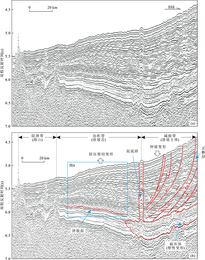
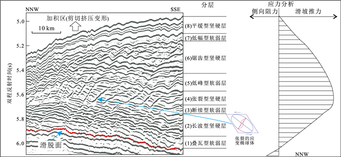
At present, the cause of sediment waves is still controversial. Detailed interpretation of the seismic profiles in the south of South China Sea, supports the discovery of an enormous submarine landslide, which covers a distance of 160 km. Analyzed from the seismic profiles, the landslide body consists of depletion zone, accumulation zone, main scarp, crown scarp, rupture surface, separation surface and transverse cracks. The submarine landslide was triggered by earthquake activity, according to the very low seabed slope (only 0.3°~0.5°) and the enormous scale of the landslide body. The sediment waves are common in the accumulation zone. Based on morphological characteristics and shearing stress analysis, the sediment waves formed through the compression of the depletion zone with a maximum stress in the middle part, leading to counter-clockwise shearing in the lower part and clockwise shearing in the upper part. Therefore, the sediment waves are soft sediment deformation caused by submarine landslide. Soft deformation sediment wave is a special mark of submarine landslide, and this study promotes the discovery of submarine landslide and also contributes to the disaster reduction and prevention of submarine engineering.
At present, the cause of sediment waves is still controversial. Detailed interpretation of the seismic profiles in the south of South China Sea, supports the discovery of an enormous submarine landslide, which covers a distance of 160 km. Analyzed from the seismic profiles, the landslide body consists of depletion zone, accumulation zone, main scarp, crown scarp, rupture surface, separation surface and transverse cracks. The submarine landslide was triggered by earthquake activity, according to the very low seabed slope (only 0.3°~0.5°) and the enormous scale of the landslide body. The sediment waves are common in the accumulation zone. Based on morphological characteristics and shearing stress analysis, the sediment waves formed through the compression of the depletion zone with a maximum stress in the middle part, leading to counter-clockwise shearing in the lower part and clockwise shearing in the upper part. Therefore, the sediment waves are soft sediment deformation caused by submarine landslide. Soft deformation sediment wave is a special mark of submarine landslide, and this study promotes the discovery of submarine landslide and also contributes to the disaster reduction and prevention of submarine engineering.


2018, 43(10): 3471-3484.
doi: 10.3799/dqkx.2018.280
Abstract:
More studies are needed in the analyse of sedimentary patterns and types of (fan) braided river deltas. In order to understand the development features and distribution of (fan) braided river delta of Oligocene coal measures in Qiongdongnan Basin, sedimentology and sequence stratigraphy have been studied on the basis of related theories and methods. Through the systematic analysis, the characteristics of the coal measures (fan) braided river delta of the Oligocene were described in detail, the basin wide sequence stratigraphic framework of the Oligocene was established, and 6 third-order sequences were identified, respectively corresponding to the 3 sections of Yacheng Formation and Lingshui Formation. According to the characters of the synsedimentary landform, fault activity, etc, five types of (fan) braided river delta (bluff, cut slope, groove type, horizontal type anticline and fault bend) were divided in Oligocene, and two sub-types of internal source and external source were further identified. It is concluded that the sequence stratigraphic framework show differences and regularity in the location, scale, and longitudinal superposition of (fan) braided river delta in different system tracts.
More studies are needed in the analyse of sedimentary patterns and types of (fan) braided river deltas. In order to understand the development features and distribution of (fan) braided river delta of Oligocene coal measures in Qiongdongnan Basin, sedimentology and sequence stratigraphy have been studied on the basis of related theories and methods. Through the systematic analysis, the characteristics of the coal measures (fan) braided river delta of the Oligocene were described in detail, the basin wide sequence stratigraphic framework of the Oligocene was established, and 6 third-order sequences were identified, respectively corresponding to the 3 sections of Yacheng Formation and Lingshui Formation. According to the characters of the synsedimentary landform, fault activity, etc, five types of (fan) braided river delta (bluff, cut slope, groove type, horizontal type anticline and fault bend) were divided in Oligocene, and two sub-types of internal source and external source were further identified. It is concluded that the sequence stratigraphic framework show differences and regularity in the location, scale, and longitudinal superposition of (fan) braided river delta in different system tracts.


2018, 43(10): 3485-3497.
doi: 10.3799/dqkx.2018.282
Abstract:
The East China Sea Shelf Basin(ECSSB) is the largest basin in the offshore China. However, there are not many progresses in oil and gas exploration due to the poor understanding of key issues of the hydrocarbon accumulation because of the lack of clear recognition of some basic geological problems, though it has been considered to be rich in hydrocarbon resources by all previous resource assessments. According to the geological data, previous studies, and existing problems of ECSSB and its adjacent regions, we propose in this paper that three key problems concerning the formation and evolution of the ECSSB are the Mesozoic basin archetype and the tectonic evolution of its peripheral regions, the differential evolution and essential reasons of the Late Mesozoic to Cenozoic rift, sedimentary filling characteristics and its controlling factors. Because of the different evolution histories of subbasins in ECSSB, there are significant differences of the key geological factors related to hydrocarbon accumulation. Thus the reservoir problem is the critical factor to affect the oil and gas accumulation in the east depression zone which mainly deposits Eocene-Oligocene sediments and the hydrocarbon potential of the source rock is the essential question about the oil-gas exploration.
The East China Sea Shelf Basin(ECSSB) is the largest basin in the offshore China. However, there are not many progresses in oil and gas exploration due to the poor understanding of key issues of the hydrocarbon accumulation because of the lack of clear recognition of some basic geological problems, though it has been considered to be rich in hydrocarbon resources by all previous resource assessments. According to the geological data, previous studies, and existing problems of ECSSB and its adjacent regions, we propose in this paper that three key problems concerning the formation and evolution of the ECSSB are the Mesozoic basin archetype and the tectonic evolution of its peripheral regions, the differential evolution and essential reasons of the Late Mesozoic to Cenozoic rift, sedimentary filling characteristics and its controlling factors. Because of the different evolution histories of subbasins in ECSSB, there are significant differences of the key geological factors related to hydrocarbon accumulation. Thus the reservoir problem is the critical factor to affect the oil and gas accumulation in the east depression zone which mainly deposits Eocene-Oligocene sediments and the hydrocarbon potential of the source rock is the essential question about the oil-gas exploration.


2018, 43(10): 3498-3510.
doi: 10.3799/dqkx.2018.323
Abstract:
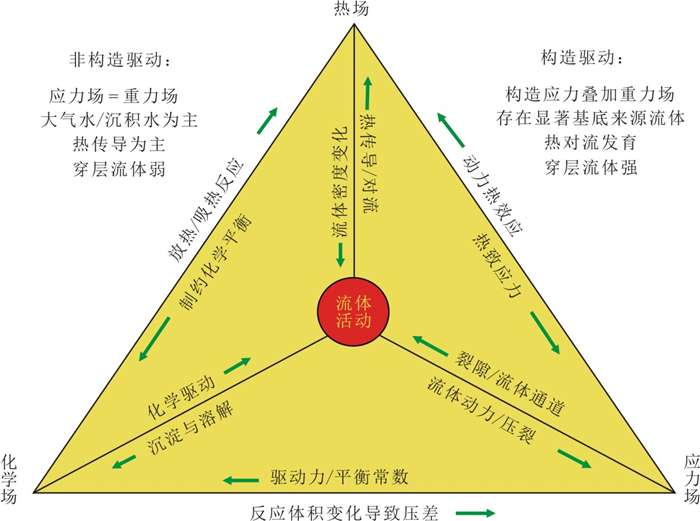
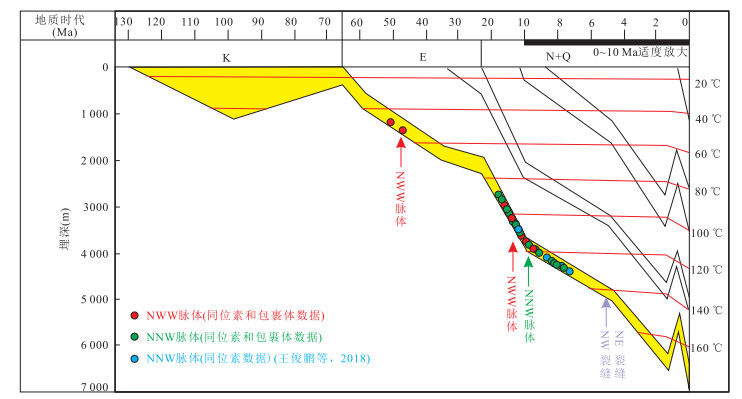
Fluid-rock interactions in sedimentary basins have been focused on the non-structural genetic mechanisms on medium and small scales in most papers published, which has constrained the understanding of the objective laws on basin-scale. The conceptual models or working modes of fluid-rock interactions driven by structural deformation (FRIDSD) in sedimentary basin evolution are presented in this paper. Conbined with the typical cases on carbonate and clastic reservoirs studied, key processes, control factors and reservoir-forming effects of FRIDSD are analysed and discussed. It is indicated that there are significant differences of FRIDSD between carbonates and sandstones in the type, intensity and distribution, exist between carbonates and sandstones. For carbonate reservoirs, it cannot be neglected that, even in weak structural deformation, dissolution and filling-cementation of carbonates related to a lot of microcracks also develop over structural traps. On the other hand, for clastic (sandstone) reservoirs, diagnostic deformation bands and their related structural diagenesis, with few microcracks, develop in weak structural deformation. However, intensive structural deformation most probably makes more (micro-) cracks and promotes FRIDSD in sandstones, which may also improve the deep-buried reservoir property to a certain extent. It is pointed out that key problems of FRIDSD mainly include intensive change of fluid pressure, petrological-mineral stabilities modified by strain, intensive/rapid change of reactive surface and volume on fluid-rock interactions.
Fluid-rock interactions in sedimentary basins have been focused on the non-structural genetic mechanisms on medium and small scales in most papers published, which has constrained the understanding of the objective laws on basin-scale. The conceptual models or working modes of fluid-rock interactions driven by structural deformation (FRIDSD) in sedimentary basin evolution are presented in this paper. Conbined with the typical cases on carbonate and clastic reservoirs studied, key processes, control factors and reservoir-forming effects of FRIDSD are analysed and discussed. It is indicated that there are significant differences of FRIDSD between carbonates and sandstones in the type, intensity and distribution, exist between carbonates and sandstones. For carbonate reservoirs, it cannot be neglected that, even in weak structural deformation, dissolution and filling-cementation of carbonates related to a lot of microcracks also develop over structural traps. On the other hand, for clastic (sandstone) reservoirs, diagnostic deformation bands and their related structural diagenesis, with few microcracks, develop in weak structural deformation. However, intensive structural deformation most probably makes more (micro-) cracks and promotes FRIDSD in sandstones, which may also improve the deep-buried reservoir property to a certain extent. It is pointed out that key problems of FRIDSD mainly include intensive change of fluid pressure, petrological-mineral stabilities modified by strain, intensive/rapid change of reactive surface and volume on fluid-rock interactions.


2018, 43(10): 3511-3525.
doi: 10.3799/dqkx.2018.286
Abstract:
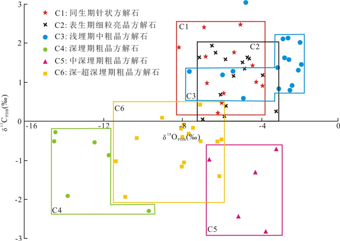
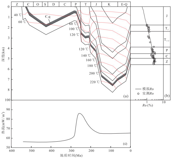
Deep marine carbonate strata are still in the early stage of exploration, and the evolution characteristics and main controlling factors of deep temperature and pressure field in marine basin are not clearly understanded. In this paper, the evolution of temperature and pressure of the Sinian gas reservoir in the central paleo-uplift of Sichuan Basin and the Ordovician condensate gas reservoir in the central uplift of Tarim Basin are reconstructed, on the basis of our summaries of suitable methods for deep marine reservoirs, in combination with our research findings and relevant literatures, the present geothermal gradient and heat flow in both the Sichuan and Tarim basins are lower. The Sinian Dengying Formation experienced the changes of warming-cooling-fast warming-fast cooling, which were mainly controlled by the heat flow and burial history. But the Ordovician in the central Tarim Basin underwent a sustained and slow warming process, and the present temperature is the highest during the geological time. The present-day pressures in both two reservoirs are in normal state. The Dengying Formation experienced the normal pressure, weak-overpressure, strong overpressure and pressure relief; but there were no obvious overpressures during the three major hydrocarbon accumulation periods in the Ordovician. The systematic research on temperature and pressure is not only very favorable for gas phase interpretations in these two gas reservoirs, but also provide modeling parameters for high temperature-high pressure experiment of carbonate rocks, improve the accumulation theory of deep marine strata, and support the further hydrocarbon exploration in deep marine gas field.
Deep marine carbonate strata are still in the early stage of exploration, and the evolution characteristics and main controlling factors of deep temperature and pressure field in marine basin are not clearly understanded. In this paper, the evolution of temperature and pressure of the Sinian gas reservoir in the central paleo-uplift of Sichuan Basin and the Ordovician condensate gas reservoir in the central uplift of Tarim Basin are reconstructed, on the basis of our summaries of suitable methods for deep marine reservoirs, in combination with our research findings and relevant literatures, the present geothermal gradient and heat flow in both the Sichuan and Tarim basins are lower. The Sinian Dengying Formation experienced the changes of warming-cooling-fast warming-fast cooling, which were mainly controlled by the heat flow and burial history. But the Ordovician in the central Tarim Basin underwent a sustained and slow warming process, and the present temperature is the highest during the geological time. The present-day pressures in both two reservoirs are in normal state. The Dengying Formation experienced the normal pressure, weak-overpressure, strong overpressure and pressure relief; but there were no obvious overpressures during the three major hydrocarbon accumulation periods in the Ordovician. The systematic research on temperature and pressure is not only very favorable for gas phase interpretations in these two gas reservoirs, but also provide modeling parameters for high temperature-high pressure experiment of carbonate rocks, improve the accumulation theory of deep marine strata, and support the further hydrocarbon exploration in deep marine gas field.


2018, 43(10): 3526-3539.
doi: 10.3799/dqkx.2018.277
Abstract:
Mixed siliciclastic-carbonate reservoir is considered as one of new important high-quality reservoirs because giant hydrocarbon accumulations have continually been discovered in the continental rifting basin, which have attracted great interest of sedimentologist. This study investigates the mixed siliciclastic-carbonate sediments in the first and second Member of the Shahejie Formation in the Bozhong Sag, Bohai Bay Basin. A combination of reservoir geological and geochemical research was used to reveal the characteristics and formation mechanisms of mixed siliciclastic-carbonate reservoirs. The results show that and bioclastic-dominated mixed rocks represent the high-quality property of reservoirs since they do not only preserve a great amount of primary pores, but also preserved an amount of primary pores with organic matter fabrics or associated secondary pores. The main diagenesis recognized in the mixed sediment reservoirs are micritization, cementation, dissolution and compaction. The micritization and precipitation of ctenoid dolomite during penecontemporaneous stage, together with meteoric dissolution during the early diagenetic period are the two key elements to form high-quality reservoirs. The micritic crusts effectively resisted the compaction, preserving high amount of primary porosity. Moreover, secondary pores were well generated by meteoric dissolution. This study on the formation conditions and controlling factors of excellent reservoirs of mixed sediment would not only provide an effective technique for the prediction of high-quality reservoirs, but also facilitate the hydrocarbon exploration at the medium-deep depth in the continental rifting basin.
Mixed siliciclastic-carbonate reservoir is considered as one of new important high-quality reservoirs because giant hydrocarbon accumulations have continually been discovered in the continental rifting basin, which have attracted great interest of sedimentologist. This study investigates the mixed siliciclastic-carbonate sediments in the first and second Member of the Shahejie Formation in the Bozhong Sag, Bohai Bay Basin. A combination of reservoir geological and geochemical research was used to reveal the characteristics and formation mechanisms of mixed siliciclastic-carbonate reservoirs. The results show that and bioclastic-dominated mixed rocks represent the high-quality property of reservoirs since they do not only preserve a great amount of primary pores, but also preserved an amount of primary pores with organic matter fabrics or associated secondary pores. The main diagenesis recognized in the mixed sediment reservoirs are micritization, cementation, dissolution and compaction. The micritization and precipitation of ctenoid dolomite during penecontemporaneous stage, together with meteoric dissolution during the early diagenetic period are the two key elements to form high-quality reservoirs. The micritic crusts effectively resisted the compaction, preserving high amount of primary porosity. Moreover, secondary pores were well generated by meteoric dissolution. This study on the formation conditions and controlling factors of excellent reservoirs of mixed sediment would not only provide an effective technique for the prediction of high-quality reservoirs, but also facilitate the hydrocarbon exploration at the medium-deep depth in the continental rifting basin.


2018, 43(10): 3540-3552.
doi: 10.3799/dqkx.2018.310
Abstract:
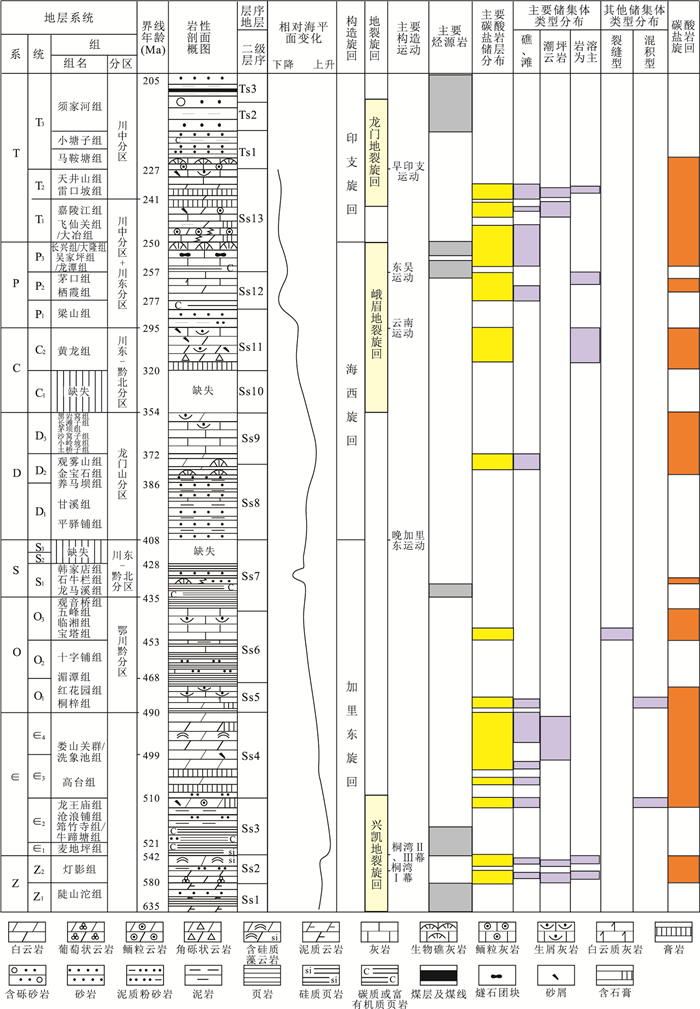
The oil/gas exploration of marine carbonate rocks in Sichuan basin has achieved a lot of breakthroughs. Several large gas field clusters have been gradually presented, and have shown the clumped distribution characteristics of carbonate reservoirs, while the assemblage structure of the reservoirs and its spatial and temporal distribution remain to be further discussed. Based on previous studies, combined with the comprehensive research on marine carbonate reservoirs in Sichuan Basin, the types, texture, and major controlling factors of carbonate cycles and assemblages under the control of tectonic and paleogeography have been systematically studied. Limited by stable clastic rock strata and large unconformity surfaces, eight carbonate cycles are divided in this paper, and each cycle has different reservoir compositions.The cycles include dolomite favorable for reservoirs such as ones of Sinian to Lower Ordovician, and Middle Permian to Middle Triassic.Combined with the tecotonic space-time distribution, and lithofacies paleography of reservoirs, carbonate rock assemblages are divided into several vertical cycles including:(1) stable platform edge reefs and shoals reservoirs on the edge of Upper Yangtze plate, (2) supergene karstification and grain beach dolomite around continuous migration paleo-uplift, (3) algal dolomite and intra-platform shoals under the background of tidal flat in the plate, (4) reef and beach dolomite reservoirs on the both sides of platform margin and intra-platform depression controlled by faults in the plate, and (5) dense limestone and karst reservoirs of carbonate ramp. It is suggested that carbonate reservoirs assemblages are controlled by dolomite which has been protected by early oil and gas charging. Carbonate reservoirs assemblages are influenced by tectonics, sea-level, and lithofacies paleography. And other factors such as karst, TSR, and hot fluids etc. influence carbonate reservoirs in local area.
The oil/gas exploration of marine carbonate rocks in Sichuan basin has achieved a lot of breakthroughs. Several large gas field clusters have been gradually presented, and have shown the clumped distribution characteristics of carbonate reservoirs, while the assemblage structure of the reservoirs and its spatial and temporal distribution remain to be further discussed. Based on previous studies, combined with the comprehensive research on marine carbonate reservoirs in Sichuan Basin, the types, texture, and major controlling factors of carbonate cycles and assemblages under the control of tectonic and paleogeography have been systematically studied. Limited by stable clastic rock strata and large unconformity surfaces, eight carbonate cycles are divided in this paper, and each cycle has different reservoir compositions.The cycles include dolomite favorable for reservoirs such as ones of Sinian to Lower Ordovician, and Middle Permian to Middle Triassic.Combined with the tecotonic space-time distribution, and lithofacies paleography of reservoirs, carbonate rock assemblages are divided into several vertical cycles including:(1) stable platform edge reefs and shoals reservoirs on the edge of Upper Yangtze plate, (2) supergene karstification and grain beach dolomite around continuous migration paleo-uplift, (3) algal dolomite and intra-platform shoals under the background of tidal flat in the plate, (4) reef and beach dolomite reservoirs on the both sides of platform margin and intra-platform depression controlled by faults in the plate, and (5) dense limestone and karst reservoirs of carbonate ramp. It is suggested that carbonate reservoirs assemblages are controlled by dolomite which has been protected by early oil and gas charging. Carbonate reservoirs assemblages are influenced by tectonics, sea-level, and lithofacies paleography. And other factors such as karst, TSR, and hot fluids etc. influence carbonate reservoirs in local area.


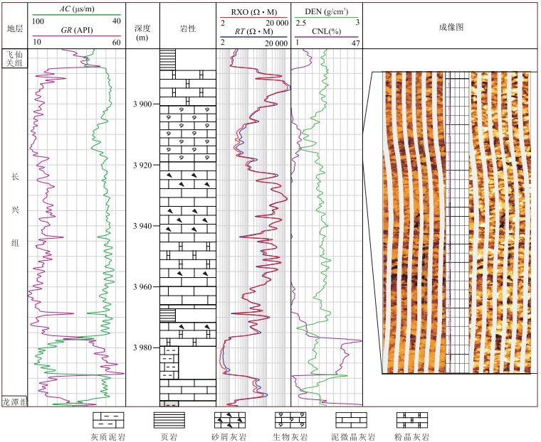
2018, 43(10): 3553-3567.
doi: 10.3799/dqkx.2018.313
Abstract:
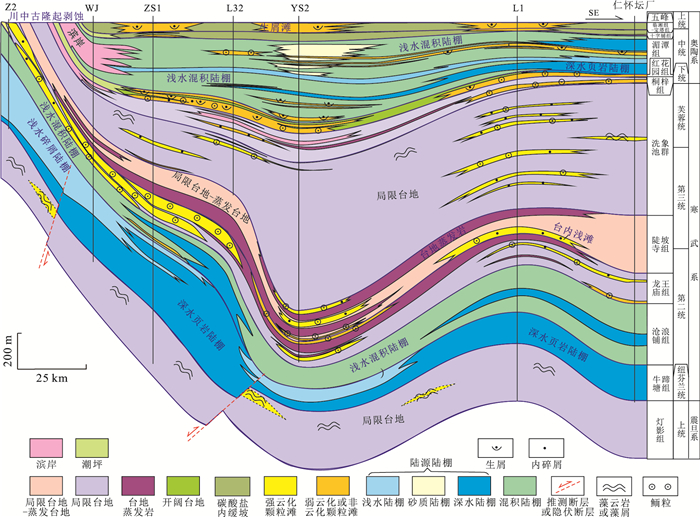
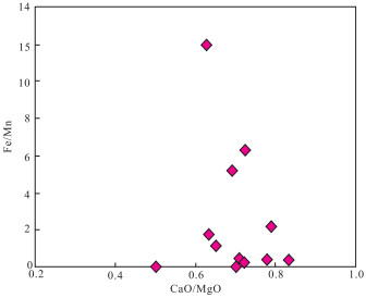
The Permian Changxing Formation is considered as one of the key exploration strata in Sichuan Basin, which develops high-quality reef-bank reservoirs. At present, there is a lack of study on the reservoir characteristics and formation. Based on the study of regional geology, rock characteristic analysis, microscopic identification, cathodoluminescence image detection, combined with determinations of trace elements and isotopes such as Sr, Fe, Mn and C, O, Sr, the petrological and geochemical characteristics of reef-shoal reservoirs on the margin of the Yanting-Tongnan trough are systematically investigated in order to reveal the genesis of the reservoir. The reef-shoal complexes are regularly distributed in the central part of Sichuan under the control of the platform margin of Yanting Tongnan trough. The reefs are mainly distributed in the Guang'an-Gongshanmiao platform margin, east of the trough, with bioclastic shoal dolostone in the reef-shoal complex as the main reservoir rock. The porosity types of the shoal reservoir consist mainly of intergranular pore and bio-framework pore with high dolomitization degree. The bioclastic dolostone is thin and widely distributed. In comparison, bioclastic shoal rather than the reefs is developed in the western side of the trough, and the bioclastic limestone is the main reservoir rock with dissolved intergranular pores, intercrystalline pores and dissolved fractures. Despite its thin single layer, the cumulative thickness of the reservoir is large and its distribution is wide. It was indicated that buried dolomitization is the main origin of dolomite reservoir in Yanting-Tongnan area, and the seawater sealed in Changxing Formation during burial period which is mixed by meteoric water and compacted porewater possibly from the bottom of Feixianguan Formation shales are the mainsources of the dolomitization fluids. Regional exposure in the late stage of Changxing formation carbonate sedimentation and buried karst are the main reasons for the formation of karst reservoirs. The high quality reservoirs in Yanting-Tongnan trough are controlled by the platform margin zone, buried dolomitization, exposure dissolution during the end of Changxing period and buried karst. And the reservoirs are supposed to be effective reservoirs due to the large scale of their large cumulative thickness and wide distribution.
The Permian Changxing Formation is considered as one of the key exploration strata in Sichuan Basin, which develops high-quality reef-bank reservoirs. At present, there is a lack of study on the reservoir characteristics and formation. Based on the study of regional geology, rock characteristic analysis, microscopic identification, cathodoluminescence image detection, combined with determinations of trace elements and isotopes such as Sr, Fe, Mn and C, O, Sr, the petrological and geochemical characteristics of reef-shoal reservoirs on the margin of the Yanting-Tongnan trough are systematically investigated in order to reveal the genesis of the reservoir. The reef-shoal complexes are regularly distributed in the central part of Sichuan under the control of the platform margin of Yanting Tongnan trough. The reefs are mainly distributed in the Guang'an-Gongshanmiao platform margin, east of the trough, with bioclastic shoal dolostone in the reef-shoal complex as the main reservoir rock. The porosity types of the shoal reservoir consist mainly of intergranular pore and bio-framework pore with high dolomitization degree. The bioclastic dolostone is thin and widely distributed. In comparison, bioclastic shoal rather than the reefs is developed in the western side of the trough, and the bioclastic limestone is the main reservoir rock with dissolved intergranular pores, intercrystalline pores and dissolved fractures. Despite its thin single layer, the cumulative thickness of the reservoir is large and its distribution is wide. It was indicated that buried dolomitization is the main origin of dolomite reservoir in Yanting-Tongnan area, and the seawater sealed in Changxing Formation during burial period which is mixed by meteoric water and compacted porewater possibly from the bottom of Feixianguan Formation shales are the mainsources of the dolomitization fluids. Regional exposure in the late stage of Changxing formation carbonate sedimentation and buried karst are the main reasons for the formation of karst reservoirs. The high quality reservoirs in Yanting-Tongnan trough are controlled by the platform margin zone, buried dolomitization, exposure dissolution during the end of Changxing period and buried karst. And the reservoirs are supposed to be effective reservoirs due to the large scale of their large cumulative thickness and wide distribution.


2018, 43(10): 3568-3583.
doi: 10.3799/dqkx.2018.229
Abstract:
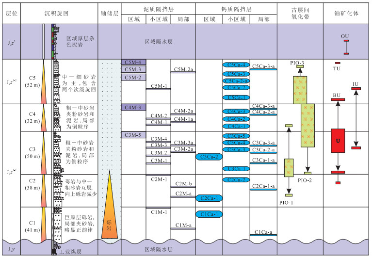
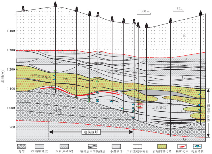
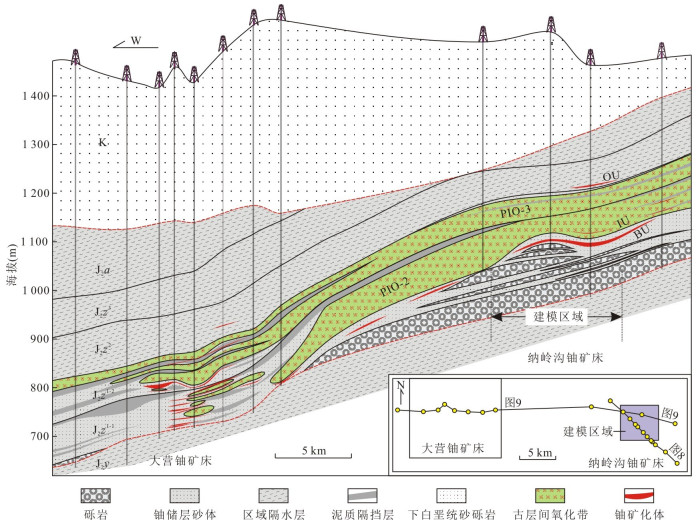
By the geological modeling of outcrop and typical uranium deposit, it can be found that there are serious sedimentary heterogeneity and diagenetic heterogeneity in uranium reservoir, that is, the differences in the structure and material composition of the uranium reservoir sandstone. On the one hand, they can control uranium mineralization by restricting uranium metallogenic flow field and interlayer oxidation, on the other hand they may also affect the dissolution flow field and selecting solvent for in-situ leaching uranium. From the discussion of uranium metallogenic mechanism and the angle of improving the recovery rate, three categories and more than ten key elements of the geological model are selected, and the spatial distribution rules of each parameter are summarized. It is found that sedimentation and sedimentary environments are the main controlling factors for the formation and development of the depositional interfaces and components of the uranium reservoir, and the diagenesis would further enhance the complexity of the structure and composition of the uranium reservoir. It is pointed out that the epigenetic alteration, which is closely related to uranium mineralization, is preferentially developed in channel units with good physical properties but low reductant abundances, indicating that the formation and development of interlayer oxidation zones and uranium deposits are highly selective. By fully comparative analysis of the characteristics of the geological modeling between outcrop and underground uranium reservoir, the research ideas which can be used for reference are summarized and the common modeling parameters are selected, which provides the basis for guiding the underground modeling. It is believed that the underground geological modeling is very predictable by the constraints of getting parameters and the precision of parameters, but it has real practical value for ore prospecting and in-situ leaching uranium when the spatial distribution and mutual restriction of key parameters are systematically summed up on the deposit scale.
By the geological modeling of outcrop and typical uranium deposit, it can be found that there are serious sedimentary heterogeneity and diagenetic heterogeneity in uranium reservoir, that is, the differences in the structure and material composition of the uranium reservoir sandstone. On the one hand, they can control uranium mineralization by restricting uranium metallogenic flow field and interlayer oxidation, on the other hand they may also affect the dissolution flow field and selecting solvent for in-situ leaching uranium. From the discussion of uranium metallogenic mechanism and the angle of improving the recovery rate, three categories and more than ten key elements of the geological model are selected, and the spatial distribution rules of each parameter are summarized. It is found that sedimentation and sedimentary environments are the main controlling factors for the formation and development of the depositional interfaces and components of the uranium reservoir, and the diagenesis would further enhance the complexity of the structure and composition of the uranium reservoir. It is pointed out that the epigenetic alteration, which is closely related to uranium mineralization, is preferentially developed in channel units with good physical properties but low reductant abundances, indicating that the formation and development of interlayer oxidation zones and uranium deposits are highly selective. By fully comparative analysis of the characteristics of the geological modeling between outcrop and underground uranium reservoir, the research ideas which can be used for reference are summarized and the common modeling parameters are selected, which provides the basis for guiding the underground modeling. It is believed that the underground geological modeling is very predictable by the constraints of getting parameters and the precision of parameters, but it has real practical value for ore prospecting and in-situ leaching uranium when the spatial distribution and mutual restriction of key parameters are systematically summed up on the deposit scale.


2018, 43(10): 3584-3602.
doi: 10.3799/dqkx.2018.233
Abstract:
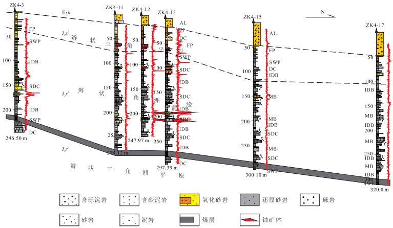
The discovery of Shihongtan uranium deposit (SUD) is a breakthrough for uranium prospecting in the Turpan-Hami Basin, followed by the discovery of, some small deposits and uranium occurrences in Baxiankou to Subashi area. Although the discovery stimulates the research on uranium mineralization within the basin, the key controlling factor for mineralization-depositional facies and microfacies of uranium-bearing sandstones has not been paid enough attention. Based upon analysis of evolution for basinal tectonics and drilling core observation combining with logging characteristics, it is found in this paper the Xishanyao Fm., deposited in braided delta environment, can fall into three intervals (Ⅰ, Ⅱand Ⅲ). The Ⅰand Ⅲ deposited in delta plain facies, while Ⅱ deposited in delta front. As the most important target layer, the Xishanyao Fm.. Ⅱ consists of subaquaceous distributary channel, mouth bar and interdistributary bay microfacies. From microscopic observation, the target layer sandstones can be classified into lithic sandstone, feldspathic lithic sandstone and lithic feldspathic sandstone. Electronic microscopic probe analysis shows that uranium is in the form of independent minerals like uraninite and titanium-bearing uranium minerals. The sections of drilling holes demonstrate uranium ore body is either roll-like or tabular due to migration of uranium-oxygen-bearing fluid flow from southeast to northwest. The relationship between uranium mineralization and depsotional facies/microfacies shows that the valuable uranium mineralization is prone to enrich along the boundary between two different microfacies, such as subaquaceous distributary channel and mouth bar, or subaquaceous distributary channel and interdistributary bay. Hence, the microfacies boundary is the key controlling factor for interlayered seepage oxidation zone sandstone-type uranium deposit in the Turpan-Hami Basin.
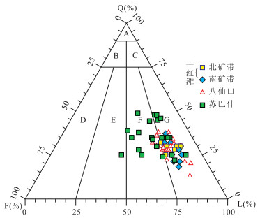
The discovery of Shihongtan uranium deposit (SUD) is a breakthrough for uranium prospecting in the Turpan-Hami Basin, followed by the discovery of, some small deposits and uranium occurrences in Baxiankou to Subashi area. Although the discovery stimulates the research on uranium mineralization within the basin, the key controlling factor for mineralization-depositional facies and microfacies of uranium-bearing sandstones has not been paid enough attention. Based upon analysis of evolution for basinal tectonics and drilling core observation combining with logging characteristics, it is found in this paper the Xishanyao Fm., deposited in braided delta environment, can fall into three intervals (Ⅰ, Ⅱand Ⅲ). The Ⅰand Ⅲ deposited in delta plain facies, while Ⅱ deposited in delta front. As the most important target layer, the Xishanyao Fm.. Ⅱ consists of subaquaceous distributary channel, mouth bar and interdistributary bay microfacies. From microscopic observation, the target layer sandstones can be classified into lithic sandstone, feldspathic lithic sandstone and lithic feldspathic sandstone. Electronic microscopic probe analysis shows that uranium is in the form of independent minerals like uraninite and titanium-bearing uranium minerals. The sections of drilling holes demonstrate uranium ore body is either roll-like or tabular due to migration of uranium-oxygen-bearing fluid flow from southeast to northwest. The relationship between uranium mineralization and depsotional facies/microfacies shows that the valuable uranium mineralization is prone to enrich along the boundary between two different microfacies, such as subaquaceous distributary channel and mouth bar, or subaquaceous distributary channel and interdistributary bay. Hence, the microfacies boundary is the key controlling factor for interlayered seepage oxidation zone sandstone-type uranium deposit in the Turpan-Hami Basin.


2018, 43(10): 3603-3615.
doi: 10.3799/dqkx.2018.223
Abstract:
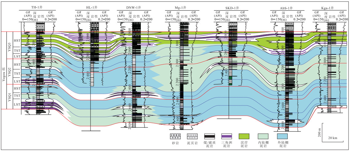
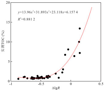
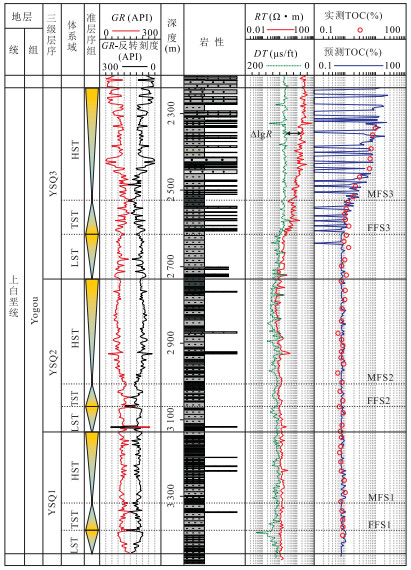
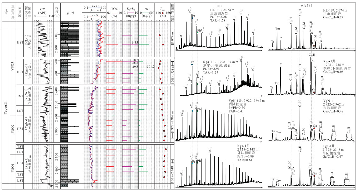
How to improve the accuracy of source rock evaluation and prediction based on limited source rock samples data and geological data is a key problem that needs to be solved in the study of source rock geochemistry.By using sequence stratigraphy and petroleum organic geochemistry, this paper studies the spatial distribution and geochemical nature of source rocks of Upper Cretaceous Yogou Formation in the Termit Basin, Niger. This case study preliminarily exhibits the method, application and advantages of geochemical sequence stratigraphy. The main source beds in the Termit Basin are the marine mudstones of the Upper Cretaceous Yogou Formation, which can be divided into three third-order sequences, namely, YSQ1, YSQ2 and YSQ3 from the bottom to the top. Five types of source rocks with different sedimentary facies were subdivided on the basis of sequence/systems tracts, lithology and loggings, which include the lower offshore, upper offshore mudstones, delta and shoreface mudstones, coal seams/carbonaceous mudstones. Different sequences and systems tracts have different vertical and areal distribution patterns of these five source rock types. The organic matters from different source rocks have distinctly different geochemical characteristics. Lower and upper offshore mudstones have fair to good hydrocarbon generative potential with more contribution of lower aquatic organisms, depositing in relatively reducing environment. While delta and shoreface mudstones have good to excellent organic carbon abundances with organic matter input of both lower aquatic organisms and terrestrial organic matter, which deposited in oxidizing environment. The occurrence and lateral distribution of different types of source rocks are evidently controlled by the sedimentary facies distribution and evolution within the third-order sequences or systems tracts, and the same type of source rocks has similar geochemical characteristics. Compared with conventional source rock geochemical assessment, geochemical sequence stratigraphy can provide a practical framework to describe the detailed geochemical characteristics of different sequences, systems tracts and depositional facies within a formation or a member, and subsequently improve the accuracy of hydrocarbon resources assessment and oil-source correlation.
How to improve the accuracy of source rock evaluation and prediction based on limited source rock samples data and geological data is a key problem that needs to be solved in the study of source rock geochemistry.By using sequence stratigraphy and petroleum organic geochemistry, this paper studies the spatial distribution and geochemical nature of source rocks of Upper Cretaceous Yogou Formation in the Termit Basin, Niger. This case study preliminarily exhibits the method, application and advantages of geochemical sequence stratigraphy. The main source beds in the Termit Basin are the marine mudstones of the Upper Cretaceous Yogou Formation, which can be divided into three third-order sequences, namely, YSQ1, YSQ2 and YSQ3 from the bottom to the top. Five types of source rocks with different sedimentary facies were subdivided on the basis of sequence/systems tracts, lithology and loggings, which include the lower offshore, upper offshore mudstones, delta and shoreface mudstones, coal seams/carbonaceous mudstones. Different sequences and systems tracts have different vertical and areal distribution patterns of these five source rock types. The organic matters from different source rocks have distinctly different geochemical characteristics. Lower and upper offshore mudstones have fair to good hydrocarbon generative potential with more contribution of lower aquatic organisms, depositing in relatively reducing environment. While delta and shoreface mudstones have good to excellent organic carbon abundances with organic matter input of both lower aquatic organisms and terrestrial organic matter, which deposited in oxidizing environment. The occurrence and lateral distribution of different types of source rocks are evidently controlled by the sedimentary facies distribution and evolution within the third-order sequences or systems tracts, and the same type of source rocks has similar geochemical characteristics. Compared with conventional source rock geochemical assessment, geochemical sequence stratigraphy can provide a practical framework to describe the detailed geochemical characteristics of different sequences, systems tracts and depositional facies within a formation or a member, and subsequently improve the accuracy of hydrocarbon resources assessment and oil-source correlation.


2018, 43(10): 3616-3624.
doi: 10.3799/dqkx.2018.225
Abstract:
In order to understand the influences of the complex faults, frequent tectonics and magmatic activitieson on hydrocarbon preservation condition in the Yanyuan Basin, the relationship between faults, magmatism and the thermal history of two primary source rock are analyzed in the adjacent areas to the west of Kangdian ancient continent in this study. The results indicate that:(1) the boundary faults and their associated secondary faults all have been active in the Himalayan period and their activities which mainly involves destroying the early oil and gas reservoirs and readjusting the spatial configuration of oil and gas, which mainly has been destructive in the self-generated in situ shale gas reservoirs. (2) The north-east and north-west folds within Yanyuan Basin may still retain relatively well-preserved structural traps and may be rich in gas and light oil. (3) In Yanyuan Basin and its adjacent areas, the Hercynian, Indosinian, Yanshanian and Himalayan magmatic activities have the following beneficial effects on hydrocarbon generation and migration:ripening source rocks, accelerating their hydrocarbon generation and providing potential migration channels; the negative effects include destroying the favorable traps or previous reservoirs, and destroying the self-generated and self-storage in situ shale gas by magmatic diapirism.
In order to understand the influences of the complex faults, frequent tectonics and magmatic activitieson on hydrocarbon preservation condition in the Yanyuan Basin, the relationship between faults, magmatism and the thermal history of two primary source rock are analyzed in the adjacent areas to the west of Kangdian ancient continent in this study. The results indicate that:(1) the boundary faults and their associated secondary faults all have been active in the Himalayan period and their activities which mainly involves destroying the early oil and gas reservoirs and readjusting the spatial configuration of oil and gas, which mainly has been destructive in the self-generated in situ shale gas reservoirs. (2) The north-east and north-west folds within Yanyuan Basin may still retain relatively well-preserved structural traps and may be rich in gas and light oil. (3) In Yanyuan Basin and its adjacent areas, the Hercynian, Indosinian, Yanshanian and Himalayan magmatic activities have the following beneficial effects on hydrocarbon generation and migration:ripening source rocks, accelerating their hydrocarbon generation and providing potential migration channels; the negative effects include destroying the favorable traps or previous reservoirs, and destroying the self-generated and self-storage in situ shale gas by magmatic diapirism.


2018, 43(10): 3625-3639.
doi: 10.3799/dqkx.2018.990
Abstract:
The tight oil and gas in terrestrial lacustrine basin shows great differences from the traditional tight/shale oil and gas.The second Member of Paleogene Kongdian Formation is an important souce rock of Cangdong Sag, Bohai Bay Basin, based on the comprehensive analysis of lithology, physical properties, hydrocarbon generation characteristics, oiliness, brittleness and exploration practice, an new oil gas reservoir was discovered in fine-grained sedimentary rocks in terrestrial lake basin, the concept of fine-grained sedimentary oil reservoir was proposed which is different from traditional tight oil gas and shale oil gas. Fine-grained sedimentary rock is mainly composed of carbonate rock, fine-grained feldspar-quartzose sedimentary rock and fine-grained mixed sedimentary rock and has the characteristic of vertically thin interbed deposits, stable plane distribution, fine hydrocarbon generation conditions, certain reservoir space, obvious hydrocarbon characteristics, high content of brittle minerals and good fracturability. These reservoirs are continuously and stably distributed in space, containing oil gas as a whole, and the dessert section is enriched, featuring high-yield. With favorable long-term stable production conditions through segmented clumps and fracturing reconstruction, it is the key areas for unconventional oil and gas exploration in terrestrial lake basin.
The tight oil and gas in terrestrial lacustrine basin shows great differences from the traditional tight/shale oil and gas.The second Member of Paleogene Kongdian Formation is an important souce rock of Cangdong Sag, Bohai Bay Basin, based on the comprehensive analysis of lithology, physical properties, hydrocarbon generation characteristics, oiliness, brittleness and exploration practice, an new oil gas reservoir was discovered in fine-grained sedimentary rocks in terrestrial lake basin, the concept of fine-grained sedimentary oil reservoir was proposed which is different from traditional tight oil gas and shale oil gas. Fine-grained sedimentary rock is mainly composed of carbonate rock, fine-grained feldspar-quartzose sedimentary rock and fine-grained mixed sedimentary rock and has the characteristic of vertically thin interbed deposits, stable plane distribution, fine hydrocarbon generation conditions, certain reservoir space, obvious hydrocarbon characteristics, high content of brittle minerals and good fracturability. These reservoirs are continuously and stably distributed in space, containing oil gas as a whole, and the dessert section is enriched, featuring high-yield. With favorable long-term stable production conditions through segmented clumps and fracturing reconstruction, it is the key areas for unconventional oil and gas exploration in terrestrial lake basin.


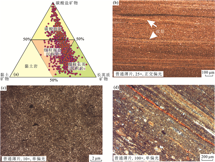


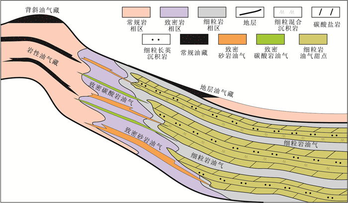

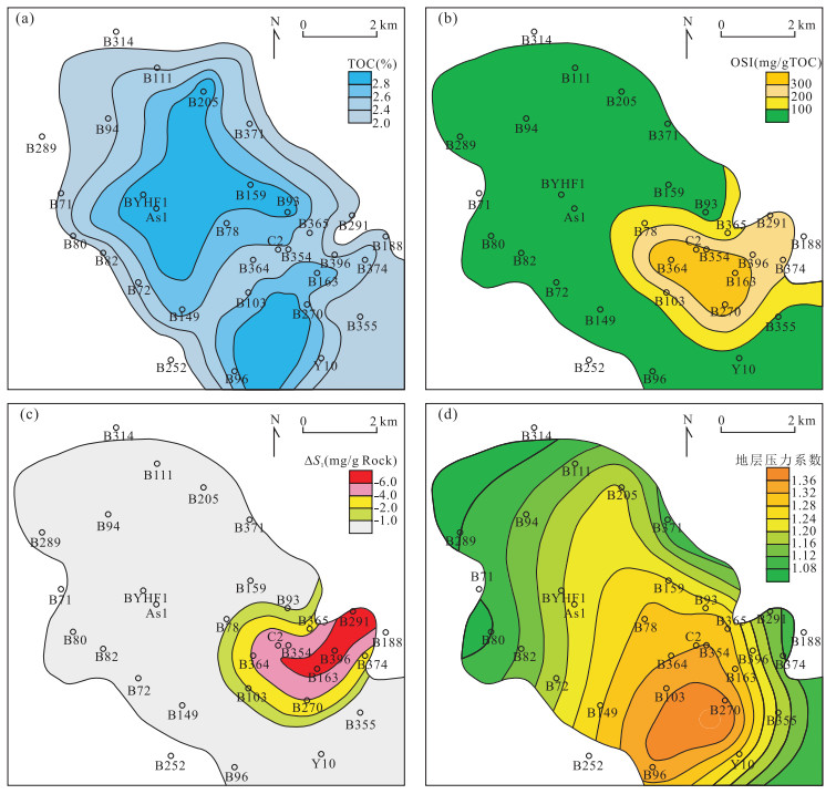
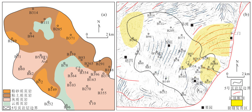
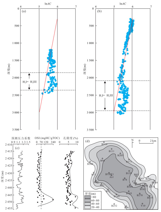
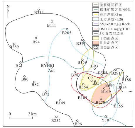
2018, 43(10): 3640-3651.
doi: 10.3799/dqkx.2018.249
Abstract:
Shale oil and gas exploration and development in China makes substantive progress, and is likely to be an important successor for oil and gas resources in the future. And the key to improve the drilling encounter rate and oil and gas yield of shale oil is prediction and evaluation of sweet spot.In this paper, taking the 5th organic-matter-rich interval (ORI 5) in the third Member of the Paleogene Hetaoyuan Formation in the Biyang Depression, the key performance indicators are applied to map out sweet spots across the deep depression by comprehensive analysis of various geophysical and geochemical methods. The key indicators are based on a limited number of shale properties, such as lithofacies, oil content, reservoir conditions, and formation pressure. The results show that:(1) The content of brittle minerals is generally larger than 50%, and the calcareous shales and argillaceous shales with silty shales interlayers are advantageous lithofacies for shale oil storage; (2) The indexes of OSI values >200 mg/g TOC and △S1 values < -2 mg/g Rock indicate the higher content of free shale oil; (3) The interlayer is mainly developed in the periphery of the deep depression, and microfracture is more developed in the derived fracture controlled zones and overlapping areas controlled by faults; (4) Overpressure may have greater impact on the small scale migration and enrichment of shale oil; (5) Shale reservoirs are evaluated based on threshold values of various indicators, and three types of sweet spots are predicted. This paper provides a valid example for comprehensive evaluation and identification of continental shale oil sweet spots using multi-parameters, and has important practical significance for guiding the shale oil exploration.
Shale oil and gas exploration and development in China makes substantive progress, and is likely to be an important successor for oil and gas resources in the future. And the key to improve the drilling encounter rate and oil and gas yield of shale oil is prediction and evaluation of sweet spot.In this paper, taking the 5th organic-matter-rich interval (ORI 5) in the third Member of the Paleogene Hetaoyuan Formation in the Biyang Depression, the key performance indicators are applied to map out sweet spots across the deep depression by comprehensive analysis of various geophysical and geochemical methods. The key indicators are based on a limited number of shale properties, such as lithofacies, oil content, reservoir conditions, and formation pressure. The results show that:(1) The content of brittle minerals is generally larger than 50%, and the calcareous shales and argillaceous shales with silty shales interlayers are advantageous lithofacies for shale oil storage; (2) The indexes of OSI values >200 mg/g TOC and △S1 values < -2 mg/g Rock indicate the higher content of free shale oil; (3) The interlayer is mainly developed in the periphery of the deep depression, and microfracture is more developed in the derived fracture controlled zones and overlapping areas controlled by faults; (4) Overpressure may have greater impact on the small scale migration and enrichment of shale oil; (5) Shale reservoirs are evaluated based on threshold values of various indicators, and three types of sweet spots are predicted. This paper provides a valid example for comprehensive evaluation and identification of continental shale oil sweet spots using multi-parameters, and has important practical significance for guiding the shale oil exploration.


2018, 43(10): 3652-3663.
doi: 10.3799/dqkx.2018.297
Abstract:
An ion-adsorption type REE deposit occurs in regolith of epimetamorphic rocks formed in Neo-Proterozoic, and has been discovered in South Jiangxi Province in recent years. Petrological and geochemical characteristics of the rocks from the REE deposit and Nanling scientific drilling were studied in this paper. Shenshan Formation and Kuli Formation are widely exposed in the deposit, and the former consists mainly of phyllite and minor schist whereas the latter consists of thick-layer metatuffite, metamorphic tuff, and medium-thick-layer metasandstone. Kuli Formation is composed of metamorphic tuff with thin layer tuffaceous slate that intersected by Nanling scientific drilling from 1 165 m to 1 170.77 m. The epimetamorphic rocks with neo formation of sericite, chlorite, magnetite, cordierite, muscovite, biotite, etc. contain REE minerals such as synchysite-(Ce), monazite, xenotime and rhabdophane-(La) etc. They are enriched in REEs (162×10-6 to 723×10-6) with high LREE/HREE ratios (LREE/HREE=2-7).We suggest that Ion-adsorbed REEs in the regolithic zone of the epimetamorphic rocks are mainly sourced from REE-fluorocarbonate. Regolith of metamorphic tuff and metatuffite formed in Cryogenian in South Jiangxi Province should be included during REE-bearing properties evaluation and prospecting.
An ion-adsorption type REE deposit occurs in regolith of epimetamorphic rocks formed in Neo-Proterozoic, and has been discovered in South Jiangxi Province in recent years. Petrological and geochemical characteristics of the rocks from the REE deposit and Nanling scientific drilling were studied in this paper. Shenshan Formation and Kuli Formation are widely exposed in the deposit, and the former consists mainly of phyllite and minor schist whereas the latter consists of thick-layer metatuffite, metamorphic tuff, and medium-thick-layer metasandstone. Kuli Formation is composed of metamorphic tuff with thin layer tuffaceous slate that intersected by Nanling scientific drilling from 1 165 m to 1 170.77 m. The epimetamorphic rocks with neo formation of sericite, chlorite, magnetite, cordierite, muscovite, biotite, etc. contain REE minerals such as synchysite-(Ce), monazite, xenotime and rhabdophane-(La) etc. They are enriched in REEs (162×10-6 to 723×10-6) with high LREE/HREE ratios (LREE/HREE=2-7).We suggest that Ion-adsorbed REEs in the regolithic zone of the epimetamorphic rocks are mainly sourced from REE-fluorocarbonate. Regolith of metamorphic tuff and metatuffite formed in Cryogenian in South Jiangxi Province should be included during REE-bearing properties evaluation and prospecting.

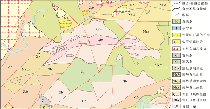

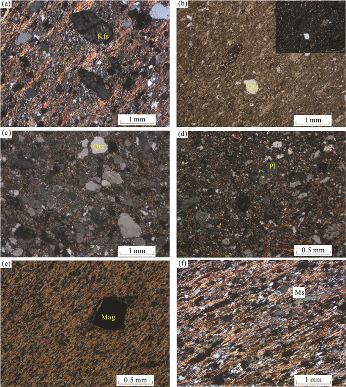


2018, 43(10): 3664-3681.
doi: 10.3799/dqkx.2018.528
Abstract:
No. 308 pegmatite vein has the maximal exposed area in the Jiajika rare metal deposit, which is the largest pegmatite type deposit in China. Because of the low degree of exploration and research, its metallogenic epoch and metallogenic mechanism remain unclear. Detailed geochronology and lithogeochemistry of the granitoids and pegmatites were carried out to explore the petrogenesis and tectonic setting cassiterite LA-MC-ICP-MS dating yields concordant ages with (210.9±4.6) Ma of spodumene-bearing pegmatite in the middle zone, which reflects that No.308 pegmatite vein in the Jiajika pegmatite deposit formed at the late stage of Indosinian and was the result of the relative stable period after the strong Indosinian Orogeny. Geochemical data show that REEs and other trace elements patterns of the barren aplite in marginal zone of No. 308 pegmatite vein are similar to the two-mica granite in the Jiajika deposit, and both of them are characterized by the peraluminous S-type granite and homology. Dfferentiation of the magmatic water gradually increased from granitic aplites to pegmatites. The granitic magma ascended and intruded under a medium-shallow deep and partial reducing environment. During the evolution of magma, there is a strong alkali metasomatism between the melt phase and the fluid phase rich in volatile, and resulting in that a large-scale rare metal mineralization occurred in the certain structural zoning of No.308 pegmatite vein in the Jiajika deposit.
No. 308 pegmatite vein has the maximal exposed area in the Jiajika rare metal deposit, which is the largest pegmatite type deposit in China. Because of the low degree of exploration and research, its metallogenic epoch and metallogenic mechanism remain unclear. Detailed geochronology and lithogeochemistry of the granitoids and pegmatites were carried out to explore the petrogenesis and tectonic setting cassiterite LA-MC-ICP-MS dating yields concordant ages with (210.9±4.6) Ma of spodumene-bearing pegmatite in the middle zone, which reflects that No.308 pegmatite vein in the Jiajika pegmatite deposit formed at the late stage of Indosinian and was the result of the relative stable period after the strong Indosinian Orogeny. Geochemical data show that REEs and other trace elements patterns of the barren aplite in marginal zone of No. 308 pegmatite vein are similar to the two-mica granite in the Jiajika deposit, and both of them are characterized by the peraluminous S-type granite and homology. Dfferentiation of the magmatic water gradually increased from granitic aplites to pegmatites. The granitic magma ascended and intruded under a medium-shallow deep and partial reducing environment. During the evolution of magma, there is a strong alkali metasomatism between the melt phase and the fluid phase rich in volatile, and resulting in that a large-scale rare metal mineralization occurred in the certain structural zoning of No.308 pegmatite vein in the Jiajika deposit.

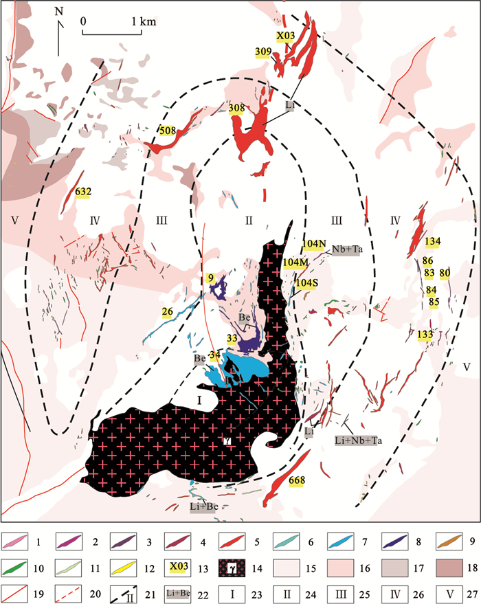

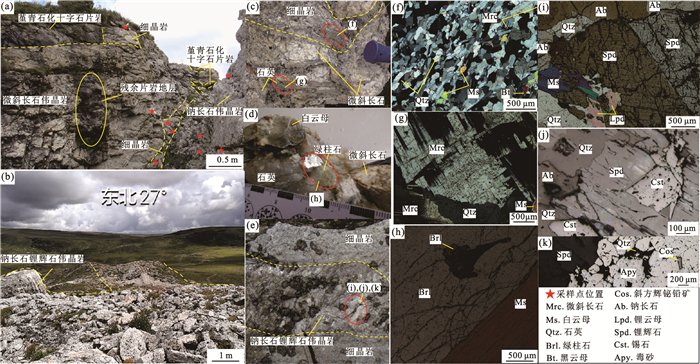


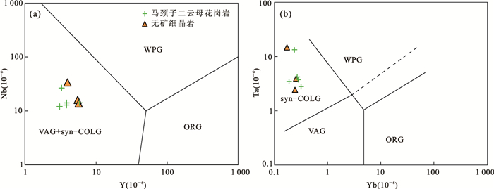


2018, 43(10): 3682-3697.
doi: 10.3799/dqkx.2018.553
Abstract:
The Littoral Fault Zone (LFZ) is an important seismic control and seismic structure in the northern continental margin of the South China Sea.The study of LFZ is related to regional seismic resistance, crustal stability evaluation and the understanding of tectonic evolution of the South China Sea. To find out the spatial variations along the strike of the LFZ, we processed the data of the onshore-offshore deep seismic experiment in Pearl River Estuary (PRE) area in 2015 and simulated a P-wave velocity model in the western PRE and detected the general location of LFZ. The results show that the LFZ dips southeast down to the Moho with a low velocity of 5.3-6.7 km/s in the crust. The basement fluctuates greatly and the depth of the Moho interface is decreases gradually from 28.5 km to 24.5 km from the onshore to offshore. Compared with previous studies in the eastern PRE, the general morphological characteristics of the LFZ on both sides of the PRE are similar. However they also show obvious differences. From east to west, the structure of the fault zone becomes more complex, with steped normal faults developed and the northern boundary fault moves northward a distance and changes into low angle normal fault with small fracture distance from steep normal fault with large break distance, and the low velocity anomaly in the fault zone gradually decreases. The results not only deepen the understanding of the shallow and deep structure of LFZ, but also provide a reference for the seismotectonics of the northern continental margin of South China Sea.
The Littoral Fault Zone (LFZ) is an important seismic control and seismic structure in the northern continental margin of the South China Sea.The study of LFZ is related to regional seismic resistance, crustal stability evaluation and the understanding of tectonic evolution of the South China Sea. To find out the spatial variations along the strike of the LFZ, we processed the data of the onshore-offshore deep seismic experiment in Pearl River Estuary (PRE) area in 2015 and simulated a P-wave velocity model in the western PRE and detected the general location of LFZ. The results show that the LFZ dips southeast down to the Moho with a low velocity of 5.3-6.7 km/s in the crust. The basement fluctuates greatly and the depth of the Moho interface is decreases gradually from 28.5 km to 24.5 km from the onshore to offshore. Compared with previous studies in the eastern PRE, the general morphological characteristics of the LFZ on both sides of the PRE are similar. However they also show obvious differences. From east to west, the structure of the fault zone becomes more complex, with steped normal faults developed and the northern boundary fault moves northward a distance and changes into low angle normal fault with small fracture distance from steep normal fault with large break distance, and the low velocity anomaly in the fault zone gradually decreases. The results not only deepen the understanding of the shallow and deep structure of LFZ, but also provide a reference for the seismotectonics of the northern continental margin of South China Sea.


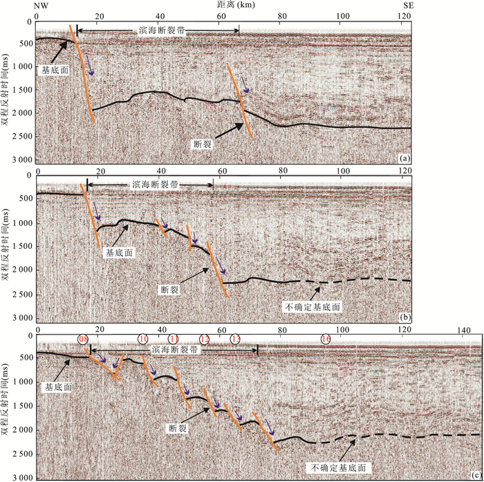


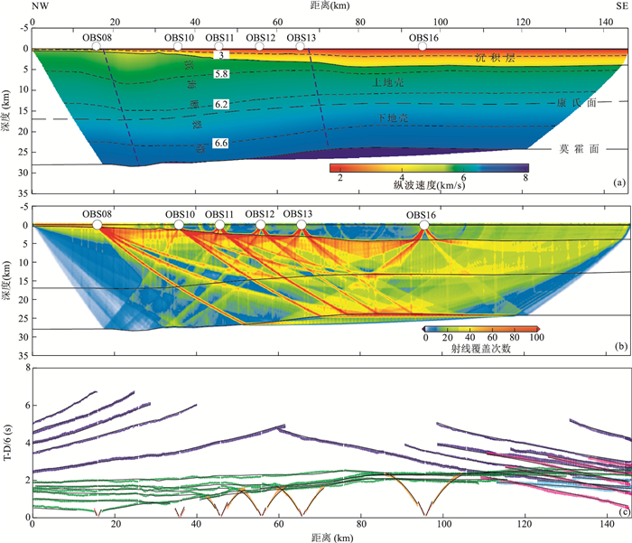
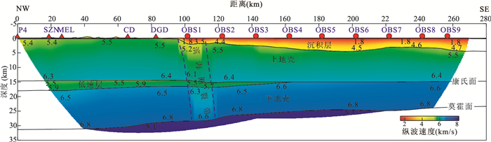

2018, 43(10): 3698-3708.
doi: 10.3799/dqkx.2018.578
Abstract:
At present, there barely have studies on the stratigraphic structure and tectonic evolution of the buried hill in southern Bohai Sea area. Combined with the 3D seismic data and well data, this study was carried out on the fault types of the buried hills, the structural styles of the buried hills and the genesis and evolution of the buried hills and dynamic background of the buried hills. The results show that the Tanlu strike-slip faults trending near SN direction and the extension faults trending near EW direction jointly controlled the stratigraphic distribution of the buried hill strata, thus affecting the structural differences of the buried hill strata. The Tanlu strike-slip fault trending near SN direction was transform fault in Indo-Chinese epoch, which regulated the compressive strength of the both sides of east and west. The compressive deformation is relatively weak on the west side of the west branch of the Tanlu strike-slip fault, which led to the general development of "thin based" or "bald based". Paleozoic structures that are dominatated by three-layer-structures of Mesozoic+Paleozoic+Precambrian. The compressive deformation on the east side of the west branch was relatively strong, which led to the development of strong uplift, where the Paleozoic stratum has been completely eroded and two-layer-structures of Mesozoic+Precambrian dominate. The reverse faults trending near EW direction were thrust faults in Indo-Chinese epoch, and developed extension and inversion in late Yanshan epoch, in which Paleozoic still remains in upthrow side of the fault but almost completely eroded in downthrow side of the fault. The diversity of the amount of lateral extrusion shrinkage was the main cause for the difference of structural styles of the buried hills in the study area.
At present, there barely have studies on the stratigraphic structure and tectonic evolution of the buried hill in southern Bohai Sea area. Combined with the 3D seismic data and well data, this study was carried out on the fault types of the buried hills, the structural styles of the buried hills and the genesis and evolution of the buried hills and dynamic background of the buried hills. The results show that the Tanlu strike-slip faults trending near SN direction and the extension faults trending near EW direction jointly controlled the stratigraphic distribution of the buried hill strata, thus affecting the structural differences of the buried hill strata. The Tanlu strike-slip fault trending near SN direction was transform fault in Indo-Chinese epoch, which regulated the compressive strength of the both sides of east and west. The compressive deformation is relatively weak on the west side of the west branch of the Tanlu strike-slip fault, which led to the general development of "thin based" or "bald based". Paleozoic structures that are dominatated by three-layer-structures of Mesozoic+Paleozoic+Precambrian. The compressive deformation on the east side of the west branch was relatively strong, which led to the development of strong uplift, where the Paleozoic stratum has been completely eroded and two-layer-structures of Mesozoic+Precambrian dominate. The reverse faults trending near EW direction were thrust faults in Indo-Chinese epoch, and developed extension and inversion in late Yanshan epoch, in which Paleozoic still remains in upthrow side of the fault but almost completely eroded in downthrow side of the fault. The diversity of the amount of lateral extrusion shrinkage was the main cause for the difference of structural styles of the buried hills in the study area.


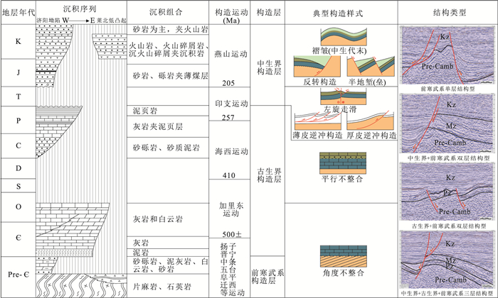
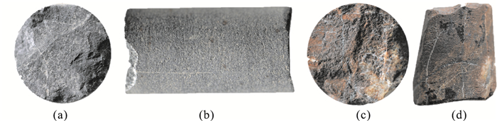


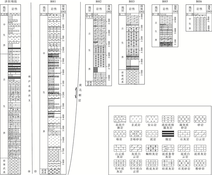


2018, 43(10): 3709-3718.
doi: 10.3799/dqkx.2017.515
Abstract:
There is a lack of systematic discussion on the sedimentary characteristics and causes of Taitung Canyon. The morphological features, sedimentary filling characteristics and origin of Taitung Canyon are analyzed by using the single-channel and multi-channel seismic profiles recently acquired in eastern Taiwan. Taitung Canyon is mainly located in the Huatung Basin and is generally oriented NE oriented with a length of 160 km, a width of 0.2-14 km in the water depth of 4 000-5 500 m.The Taitung Canyon can be divided into three types in profile shape:V, U, complex types and three segments in plane:upper, middle and lower segments, which are NE-NEE-striking, NE-NNW-striking and NE-striking respectively. Mass movements such as slides or slumps are ubiquitous in the upper of Taitung Canyon, which are driven by a variety of erosional processes from gravity flow erosion to turbidity current. Wavy deposition can be observed in the flank of the middle section of Taitung Canyon, which may be formed by turbidity current. The sufficient deposits could be discharged at the lower of Taitung Canyon, where the modern submarine fan developed.The formation and development of the Taitung Canyon resulted from the interaction between the tectonic activity, topography and deep-water deposition. Upper segment is controlled by topography and deep-water deposition. Gravity flow deposition provides a material and power source for the erosion and fills in the canyon.The middle segment is controlled by tectonism, which Gagua Ridge changes the orientation of the middle reach of Taitung Canyon; The deep-water fan, located at the end of Taitung Canyon, is controlled by "trumpet" topography.When they get rid of the lateral constraints from Gagua Ridge, the debris occur to unload, resulting in a large deepwater fan.
There is a lack of systematic discussion on the sedimentary characteristics and causes of Taitung Canyon. The morphological features, sedimentary filling characteristics and origin of Taitung Canyon are analyzed by using the single-channel and multi-channel seismic profiles recently acquired in eastern Taiwan. Taitung Canyon is mainly located in the Huatung Basin and is generally oriented NE oriented with a length of 160 km, a width of 0.2-14 km in the water depth of 4 000-5 500 m.The Taitung Canyon can be divided into three types in profile shape:V, U, complex types and three segments in plane:upper, middle and lower segments, which are NE-NEE-striking, NE-NNW-striking and NE-striking respectively. Mass movements such as slides or slumps are ubiquitous in the upper of Taitung Canyon, which are driven by a variety of erosional processes from gravity flow erosion to turbidity current. Wavy deposition can be observed in the flank of the middle section of Taitung Canyon, which may be formed by turbidity current. The sufficient deposits could be discharged at the lower of Taitung Canyon, where the modern submarine fan developed.The formation and development of the Taitung Canyon resulted from the interaction between the tectonic activity, topography and deep-water deposition. Upper segment is controlled by topography and deep-water deposition. Gravity flow deposition provides a material and power source for the erosion and fills in the canyon.The middle segment is controlled by tectonism, which Gagua Ridge changes the orientation of the middle reach of Taitung Canyon; The deep-water fan, located at the end of Taitung Canyon, is controlled by "trumpet" topography.When they get rid of the lateral constraints from Gagua Ridge, the debris occur to unload, resulting in a large deepwater fan.


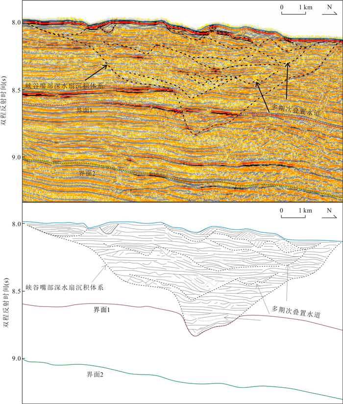
2018, 43(10): 3719-3732.
doi: 10.3799/dqkx.2017.609
Abstract:
As a hot and difficult research topic in the field of oil and gas geology, it is hard to clarify the tight oil charging and accumulating mechanism, migration and accumulation processes by a single approach. Taking the tight oil layers in the Lucaogu Formation in the Jimsar Sag of the Junggar Basin as an example, oil migration and accumulation processes in tight reservoir beds have been examined by combining physical modeling experiments of oil charging with the analysis of the process of diagenesis-reservoir formation-hydrocarbon generation and accumulation in this study. Has entered oil-generating window since Late Triassic period (corresponding to Ro=0.5%), and has entered massive hydrocarbon generation stage since Middle Jurassic period (corresponding to Ro=0.7%), the source rock in the Lucaogu Formation is still at the oil generation stage now. Many studies on hydrocarbon inclusions show that the Jimsar Sag has experienced two stages of hydrocarbon accumulation:the first stage was in Jurassic period (with inclusion homogenization temperature at 50~70℃, and the second stage was in Cretaceous-Paleogene period (with inclusion homogenization temperature at about 120℃). The diagenetic stages of tight reservoir beds in the Lucaogu Formation in the Jimsar Sag can be classified into three periods:①Period A in early diagenesis:early period of Late Permian (260 Ma) and before; ② Period B in early diagenesis:from early period of Late Permian to Late Triassic (260-220 Ma); ③Period A in middle diagenesis:from Late Triassic to present (220~0 Ma). According to analysis of diagenetic evolution stages and hydrocarbon accumulation process, and the conclusions from the physical modeling of oil charging in tight reservoir beds, the process of diagenesis-reservoir formation-hydrocarbon accumulation of tight oil in the Lucaogu Formation can be divided into the following three periods:(1) low-maturity oil and gas charging period under medium-high porosity and permeability condition in early reservoir beds (before Late Triassic); (2) the period that simultaneous tightness and accumulation occurs, and rock surface wettability changing to oilwet (from Late Triassic to the end of Early Cretaceous); (3) continuous charging period of mature oil in tight reservoir beds in the Lucaogu Formation (the end of Early Cretaceous to present). The Lucaogu Formation in the Jimsar Sag has large tight oil resource reserves potentials. The geological resources reserves of tight oil in upper sweet spot volume (Section B) are about 4.45×10⁸ t, and in lower sweet spot volume (Section E) are about 7.95×10⁸ t.
As a hot and difficult research topic in the field of oil and gas geology, it is hard to clarify the tight oil charging and accumulating mechanism, migration and accumulation processes by a single approach. Taking the tight oil layers in the Lucaogu Formation in the Jimsar Sag of the Junggar Basin as an example, oil migration and accumulation processes in tight reservoir beds have been examined by combining physical modeling experiments of oil charging with the analysis of the process of diagenesis-reservoir formation-hydrocarbon generation and accumulation in this study. Has entered oil-generating window since Late Triassic period (corresponding to Ro=0.5%), and has entered massive hydrocarbon generation stage since Middle Jurassic period (corresponding to Ro=0.7%), the source rock in the Lucaogu Formation is still at the oil generation stage now. Many studies on hydrocarbon inclusions show that the Jimsar Sag has experienced two stages of hydrocarbon accumulation:the first stage was in Jurassic period (with inclusion homogenization temperature at 50~70℃, and the second stage was in Cretaceous-Paleogene period (with inclusion homogenization temperature at about 120℃). The diagenetic stages of tight reservoir beds in the Lucaogu Formation in the Jimsar Sag can be classified into three periods:①Period A in early diagenesis:early period of Late Permian (260 Ma) and before; ② Period B in early diagenesis:from early period of Late Permian to Late Triassic (260-220 Ma); ③Period A in middle diagenesis:from Late Triassic to present (220~0 Ma). According to analysis of diagenetic evolution stages and hydrocarbon accumulation process, and the conclusions from the physical modeling of oil charging in tight reservoir beds, the process of diagenesis-reservoir formation-hydrocarbon accumulation of tight oil in the Lucaogu Formation can be divided into the following three periods:(1) low-maturity oil and gas charging period under medium-high porosity and permeability condition in early reservoir beds (before Late Triassic); (2) the period that simultaneous tightness and accumulation occurs, and rock surface wettability changing to oilwet (from Late Triassic to the end of Early Cretaceous); (3) continuous charging period of mature oil in tight reservoir beds in the Lucaogu Formation (the end of Early Cretaceous to present). The Lucaogu Formation in the Jimsar Sag has large tight oil resource reserves potentials. The geological resources reserves of tight oil in upper sweet spot volume (Section B) are about 4.45×10⁸ t, and in lower sweet spot volume (Section E) are about 7.95×10⁸ t.


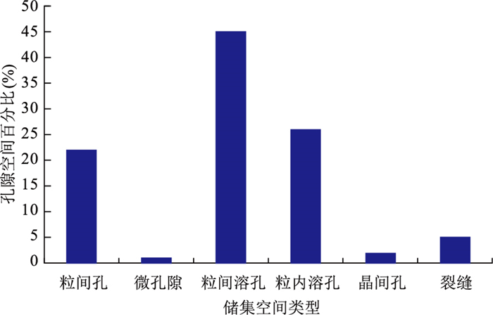
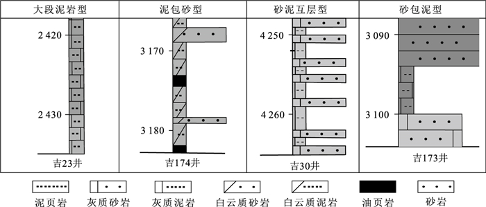

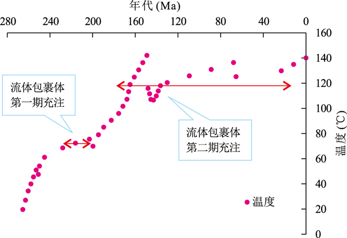


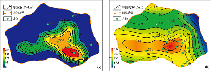
2018, 43(10): 3733-3748.
doi: 10.3799/dqkx.2018.252
Abstract:
Thick synsedimentary laminaes and strines consisting of white grains were recently described in Lower Cretaceous lacustrine rocks in Baiyinchagan Sag of Erlian Basin, which include enormous quantities of natrolite and analcime. Based on analysis of thin sections and Electron Probe Micro-anlyzer (EPMA), micro-morphology, texture and trace element composition of natrolite and analcime were determined using Field Emission Scanning Electron Microscopy (FE-SEM) and Inductively Coupled Plasma-Mass Spectrometry (ICP-MS). FE-SEM observations show that natrolite comprises subhedral-euhedral prismatic crystals that extend along one-dismensional axial with the maximum size of 600 μm and forms fibrous and massive aggregates. Analcime is composed of euhedral tetrakisoctahedron crystals ranging from 10 μm to 300 μm in diameters. In most cases, natrolite and analcime occur together and mutually replace. They coexist with barite, ferriferous dolomite, pyrite, magnesite and siderite as their paragenetic minerals. Compared with crust and mudstone of the same strata in research area, zeolite-bearing rocks contain high values of Pb, Sb, TI, Mo, W, Bi and have a severe depletion in V, Cr, Co, Ni, which suggest hydrothermal fluids including mantle-derived materials involved during sedimentary processes. Mineralogical and geochemical investigations of assemblages of natrolite and analcime suggests a result of direct precipitation during the mixing of hydrothermal fluids and lake water at the bottom of lake related to continental rift, in which faults act as migration pathways and hydrothermal fluids are derived by an abnormal heat convection system.
Thick synsedimentary laminaes and strines consisting of white grains were recently described in Lower Cretaceous lacustrine rocks in Baiyinchagan Sag of Erlian Basin, which include enormous quantities of natrolite and analcime. Based on analysis of thin sections and Electron Probe Micro-anlyzer (EPMA), micro-morphology, texture and trace element composition of natrolite and analcime were determined using Field Emission Scanning Electron Microscopy (FE-SEM) and Inductively Coupled Plasma-Mass Spectrometry (ICP-MS). FE-SEM observations show that natrolite comprises subhedral-euhedral prismatic crystals that extend along one-dismensional axial with the maximum size of 600 μm and forms fibrous and massive aggregates. Analcime is composed of euhedral tetrakisoctahedron crystals ranging from 10 μm to 300 μm in diameters. In most cases, natrolite and analcime occur together and mutually replace. They coexist with barite, ferriferous dolomite, pyrite, magnesite and siderite as their paragenetic minerals. Compared with crust and mudstone of the same strata in research area, zeolite-bearing rocks contain high values of Pb, Sb, TI, Mo, W, Bi and have a severe depletion in V, Cr, Co, Ni, which suggest hydrothermal fluids including mantle-derived materials involved during sedimentary processes. Mineralogical and geochemical investigations of assemblages of natrolite and analcime suggests a result of direct precipitation during the mixing of hydrothermal fluids and lake water at the bottom of lake related to continental rift, in which faults act as migration pathways and hydrothermal fluids are derived by an abnormal heat convection system.

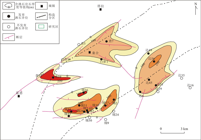


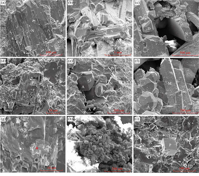

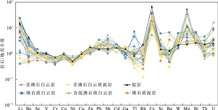
2018, 43(10): 3749-3761.
doi: 10.3799/dqkx.2018.573
Abstract:
The deep velocity structures are the basis for building the formation and revolution of the South China Sea (SCS). Two-dimensional (2D) and three-dimensional (3D) OBS surveys are successful technique to acquire the deep seismic structures. The results from 3D OBS surveys in the SCS have enhanced the knowledge for theoretical concepts. In the Southwest sub-basin, the asymmetrical velocity structures have been presented across the extinct spreading ridge (ESR) due to the development of detachment faults. In the central part of the east sub-basin, four types of crust have been defined:thin oceanic crust (< 5 km); typical oceanic crust (5-6 km); thick oceanic crust hosting post-spreading volcanoes ( > 6 km) with significant intrusive roots; and thick oceanic crust with enhanced spreading features ( > 6 km) but without significant roots. The post-spreading volcanoes (Zhenbei-Huangyan seamounts chain) were formed 6-10 Ma ago during a N-S tensional episode, several millions of years after seafloor spreading ceased in the SCS, and emplaced where the crust was the weakest, might have been influenced by the Hainan plume activity through a buoyancy-driven partial melting mechanism. The study on Dongsha uplift highlights magmatic activities through upwelling channels after rifting ceasing. The velocity structure in the Manila subduction zone (northeastern SCS) shows the nature of the crust and its relationship with the Manila subduction slab. A 3D OBS survey will be carried out in 2018 in the area of the IODP Legs 367-368, aiming at building a model of lithospheric rifting and breakup mechanism in the continent-ocean-transition (COT) zone of the SCS. The joint 2D and 3D survey method will play a major role in the understanding of the SCS geodynamics by integrating IODP drilling results with information on the deep structures.
The deep velocity structures are the basis for building the formation and revolution of the South China Sea (SCS). Two-dimensional (2D) and three-dimensional (3D) OBS surveys are successful technique to acquire the deep seismic structures. The results from 3D OBS surveys in the SCS have enhanced the knowledge for theoretical concepts. In the Southwest sub-basin, the asymmetrical velocity structures have been presented across the extinct spreading ridge (ESR) due to the development of detachment faults. In the central part of the east sub-basin, four types of crust have been defined:thin oceanic crust (< 5 km); typical oceanic crust (5-6 km); thick oceanic crust hosting post-spreading volcanoes ( > 6 km) with significant intrusive roots; and thick oceanic crust with enhanced spreading features ( > 6 km) but without significant roots. The post-spreading volcanoes (Zhenbei-Huangyan seamounts chain) were formed 6-10 Ma ago during a N-S tensional episode, several millions of years after seafloor spreading ceased in the SCS, and emplaced where the crust was the weakest, might have been influenced by the Hainan plume activity through a buoyancy-driven partial melting mechanism. The study on Dongsha uplift highlights magmatic activities through upwelling channels after rifting ceasing. The velocity structure in the Manila subduction zone (northeastern SCS) shows the nature of the crust and its relationship with the Manila subduction slab. A 3D OBS survey will be carried out in 2018 in the area of the IODP Legs 367-368, aiming at building a model of lithospheric rifting and breakup mechanism in the continent-ocean-transition (COT) zone of the SCS. The joint 2D and 3D survey method will play a major role in the understanding of the SCS geodynamics by integrating IODP drilling results with information on the deep structures.


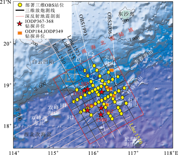
2018, 43(10): 3762-3777.
doi: 10.3799/dqkx.2018.581
Abstract:
In order to investigate how the extension induced by subduction direction inversion affects the continental breakup, we conduct numerical simulation to represent the subduction process in the early stage and the extension induced by subduction direction inversion in the later stage. Meanwhile, different geological bodies, such as oceanic plate with smooth surface, seamount chains, oceanic plateau and weak zone, are added in the model during the early subduction stage. Results show that the extension induced by subduction direction inversion would cause lithospheric thinning, necking and breakup, being accompanied by asthenospheric upwelling and partial melting due to decompression. In addition, the margin deforms to different degrees once the geological bodies enter the early subduction, exerting influence on the strain localization in the subsequent extension, leading to the lithospheric breakup at various locations and start timings. Our results are compatible with the characteristics of timing migration of breakup unconformity in the South China Sea margin, and also offer reference for the geodynamic studies in other passive margins.
In order to investigate how the extension induced by subduction direction inversion affects the continental breakup, we conduct numerical simulation to represent the subduction process in the early stage and the extension induced by subduction direction inversion in the later stage. Meanwhile, different geological bodies, such as oceanic plate with smooth surface, seamount chains, oceanic plateau and weak zone, are added in the model during the early subduction stage. Results show that the extension induced by subduction direction inversion would cause lithospheric thinning, necking and breakup, being accompanied by asthenospheric upwelling and partial melting due to decompression. In addition, the margin deforms to different degrees once the geological bodies enter the early subduction, exerting influence on the strain localization in the subsequent extension, leading to the lithospheric breakup at various locations and start timings. Our results are compatible with the characteristics of timing migration of breakup unconformity in the South China Sea margin, and also offer reference for the geodynamic studies in other passive margins.
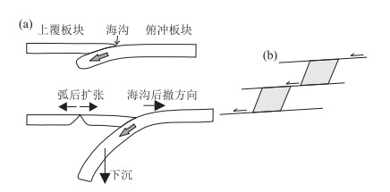

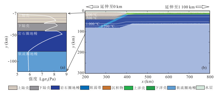


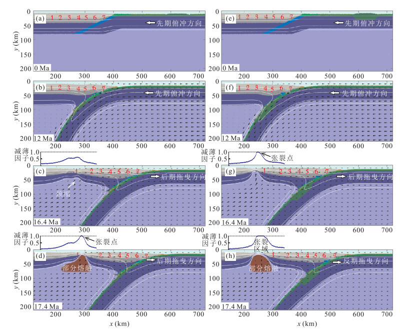


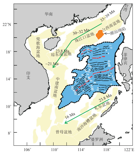
2018, 43(10): 3778-3791.
doi: 10.3799/dqkx.2018.534
Abstract:
Shear waves are polarized waves showing different characteristics from compressional waves, which are specially important to the seismic exploration. They have been widely used in the passive-source seismic studies, such as the receiver functions and shear wave splitting. However the application of shear waves is still limited in the active-source ocean bottom seismometer exploration. Shear waves are converted waves for the underwater seismic source. In this paper, we firstly summarize the conversion, mode type, processes and identification of shear waves. And we also use real examples to introduce different applications in different oceans. The studies of converted shear waves are mainly used to reveal the submarine rock property, infer the crustal type, discuss the conjugate relationship of the continental margin, identify the mantle serpentinization, infer gas hydrate saturation and predict the fluids based on 1D/2D converted shear waves. Numerous 2D/3D OBS data have been collected in the South China Sea, hence we can gradually change the studies of converted shear waves from 2D to 3D and conduct analysis in combination with other geophysical data. Using those data will help to reveal the composition of seamounts and identify the porosity of the low-velocity upper mantle in the South China Sea.
Shear waves are polarized waves showing different characteristics from compressional waves, which are specially important to the seismic exploration. They have been widely used in the passive-source seismic studies, such as the receiver functions and shear wave splitting. However the application of shear waves is still limited in the active-source ocean bottom seismometer exploration. Shear waves are converted waves for the underwater seismic source. In this paper, we firstly summarize the conversion, mode type, processes and identification of shear waves. And we also use real examples to introduce different applications in different oceans. The studies of converted shear waves are mainly used to reveal the submarine rock property, infer the crustal type, discuss the conjugate relationship of the continental margin, identify the mantle serpentinization, infer gas hydrate saturation and predict the fluids based on 1D/2D converted shear waves. Numerous 2D/3D OBS data have been collected in the South China Sea, hence we can gradually change the studies of converted shear waves from 2D to 3D and conduct analysis in combination with other geophysical data. Using those data will help to reveal the composition of seamounts and identify the porosity of the low-velocity upper mantle in the South China Sea.


2018, 43(10): 3792-3798.
doi: 10.3799/dqkx.2016.551
Abstract:
Based on Weaver's model, we analyze the magnetic noise variations of the towed Overhauser marine magnetic sensor associated with the different ocean depths, wave periods and amplitudes in theory, proving the necessity of suppressing the magnetic noise in the extreme ocean conditions. In this paper, we propose a novel real-time reduction method of the magnetic noise via an improved Sage-Husa adaptive Kalman filter (KF) to improve the sensor sensitivity. The simulation results show that the proposed method could achieve the fast convergence of the covariance of magnetic noise without the priori noise statistics or real-time reference noise. Furthermore, the dependency on the initial parameters is reduced compared with the standard Sage-Husa algorithm. In addition, we implement a towed Overhauser marine magnetometer to test the proposed method. Over all, the comparison experiments show that the proposed method not only realizes the adaptive estimation of the magnetic noise statistics, but also has better suppression effect than the standard KF. The power spectral density of the magnetic noise is reduced to 6 pT/Hz1/2@1Hz from 50 pT/Hz1/2@1Hz after flitting.
Based on Weaver's model, we analyze the magnetic noise variations of the towed Overhauser marine magnetic sensor associated with the different ocean depths, wave periods and amplitudes in theory, proving the necessity of suppressing the magnetic noise in the extreme ocean conditions. In this paper, we propose a novel real-time reduction method of the magnetic noise via an improved Sage-Husa adaptive Kalman filter (KF) to improve the sensor sensitivity. The simulation results show that the proposed method could achieve the fast convergence of the covariance of magnetic noise without the priori noise statistics or real-time reference noise. Furthermore, the dependency on the initial parameters is reduced compared with the standard Sage-Husa algorithm. In addition, we implement a towed Overhauser marine magnetometer to test the proposed method. Over all, the comparison experiments show that the proposed method not only realizes the adaptive estimation of the magnetic noise statistics, but also has better suppression effect than the standard KF. The power spectral density of the magnetic noise is reduced to 6 pT/Hz1/2@1Hz from 50 pT/Hz1/2@1Hz after flitting.
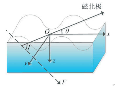
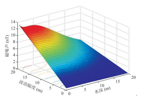
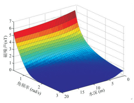


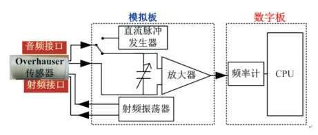


2018, 43(10): 3799-3808.
doi: 10.3799/dqkx.2017.521
Abstract:
The proppant placement and fracture geometric parameters evaluation in hydraulic fractures are essential to optimize the stimulation strategy in unconventional oil and gas production. A new method adopting Gd as a tracer to detect hydraulic fracture near wellbore is proposed in this paper. Based on the numerical simulation and thermal neutron diffusion theory, the induced fracture width evaluation parameter WTN is defined. Then, the effect of lithology, porosity, borehole diameter, salinity and oil saturation to determination of fracture width is analyzed. The results indicate that WTN exponentially increases before leveling off with the increases of induced fracture width. The larger the porosity, and the smaller the formation water salinity, the smaller the WTN is. The dimension of hole and oil saturation have little effect on WTN. Monte Carlo method is employed to build formation model before and after hydrulic fracturing and thermal neutron distribution in strata of different depths is simulated. Also, the response curves of thermal neutron count NEAR, FAR and WTN are obtained. It is found that the fracture parameter results are consistent with the setting model, showing that the thermal neutron detection method based on Gd tracing can be used to evaluate the fracture of near wellbore.
The proppant placement and fracture geometric parameters evaluation in hydraulic fractures are essential to optimize the stimulation strategy in unconventional oil and gas production. A new method adopting Gd as a tracer to detect hydraulic fracture near wellbore is proposed in this paper. Based on the numerical simulation and thermal neutron diffusion theory, the induced fracture width evaluation parameter WTN is defined. Then, the effect of lithology, porosity, borehole diameter, salinity and oil saturation to determination of fracture width is analyzed. The results indicate that WTN exponentially increases before leveling off with the increases of induced fracture width. The larger the porosity, and the smaller the formation water salinity, the smaller the WTN is. The dimension of hole and oil saturation have little effect on WTN. Monte Carlo method is employed to build formation model before and after hydrulic fracturing and thermal neutron distribution in strata of different depths is simulated. Also, the response curves of thermal neutron count NEAR, FAR and WTN are obtained. It is found that the fracture parameter results are consistent with the setting model, showing that the thermal neutron detection method based on Gd tracing can be used to evaluate the fracture of near wellbore.