2018 Vol. 43, No. 11
Display Method:
 PDF 352KB
2018, 43(11): 3809-3822.
doi: 10.3799/dqkx.2018.117
Abstract:
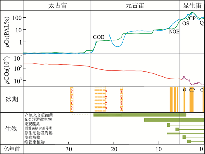
The impact of organisms on the carbon cycle since Proterozoic should not be underestimated. Oxygenic photosynthesis of organisms produces organic matter and O2 while consuming CO2. Burying of organic matter and biogenic carbonates further sequestrates CO2 and decreases the consumption of O2. It is thus reasonable that causal relationship should exist among oxygenic photosynthesis of organisms, icehouse climates and oxygenation events. In this paper, we discuss 5 events, namely, the Early Proterozoic great oxygenation event (GOE) in connection with oxygenic photosynthesis of cyanobacteria, the Neoproterozoic oxidation event (NOE) in connection with radiation of eukaryotes, the Late Ordovician oxygenic-icehouse event in connection with flourish of early land plants, the Carboniferous-Permian oxygenation icehouse event in connection with flourish of vascular plants, and the Quaternary icehouse event in connection with angiosperms and phytoplanktons. In these events, such causality is indicated by coexistences or successive appearances of icehouse climates and oxygenation events, reflecting atmospheric CO2 decreases and O2 increases, which are possible only through biogenic photosynthesis and successive burying of its products. Causal relationship among oxygenic photosynthesis of organisms, oxygenation and icehouse climate indicates the interaction between organisms and their environments. Organisms do not merely adapt to their environments, they also influence the environments. In the prolonged geologic history, such interaction formed co-evolution between the two. However, biotic oxygenation did not immediately produce oxygenic or icehouse effects in early geologic history. Such effects were minimal at first and accumulated gradually, and became efficient when reaching certain threshold, so usually delayed in time. Following the increase of biotic diversity, abundance and metabolic ability, its impact on environments became stronger, time-delay decreased and coupling increased. Such interaction between organism and environment forms the self-regulation between biosphere and earth system, which explains why, unlike other planets, the Earth's surface has been maintaining a habitable environment. The lesson for mankind is that we should treat the relationship scientifically, so as to avoid negative impact on our mother earth.
The impact of organisms on the carbon cycle since Proterozoic should not be underestimated. Oxygenic photosynthesis of organisms produces organic matter and O2 while consuming CO2. Burying of organic matter and biogenic carbonates further sequestrates CO2 and decreases the consumption of O2. It is thus reasonable that causal relationship should exist among oxygenic photosynthesis of organisms, icehouse climates and oxygenation events. In this paper, we discuss 5 events, namely, the Early Proterozoic great oxygenation event (GOE) in connection with oxygenic photosynthesis of cyanobacteria, the Neoproterozoic oxidation event (NOE) in connection with radiation of eukaryotes, the Late Ordovician oxygenic-icehouse event in connection with flourish of early land plants, the Carboniferous-Permian oxygenation icehouse event in connection with flourish of vascular plants, and the Quaternary icehouse event in connection with angiosperms and phytoplanktons. In these events, such causality is indicated by coexistences or successive appearances of icehouse climates and oxygenation events, reflecting atmospheric CO2 decreases and O2 increases, which are possible only through biogenic photosynthesis and successive burying of its products. Causal relationship among oxygenic photosynthesis of organisms, oxygenation and icehouse climate indicates the interaction between organisms and their environments. Organisms do not merely adapt to their environments, they also influence the environments. In the prolonged geologic history, such interaction formed co-evolution between the two. However, biotic oxygenation did not immediately produce oxygenic or icehouse effects in early geologic history. Such effects were minimal at first and accumulated gradually, and became efficient when reaching certain threshold, so usually delayed in time. Following the increase of biotic diversity, abundance and metabolic ability, its impact on environments became stronger, time-delay decreased and coupling increased. Such interaction between organism and environment forms the self-regulation between biosphere and earth system, which explains why, unlike other planets, the Earth's surface has been maintaining a habitable environment. The lesson for mankind is that we should treat the relationship scientifically, so as to avoid negative impact on our mother earth.

2018, 43(11): 3823-3836.
doi: 10.3799/dqkx.2018.169
Abstract:
To serve the society has always been the main goal for all the scientific research of geosciences, which is of particular significance in the globalization contexts. Paleontology, an important conventional academic disciplinary branch of geology, has already developed into a new stage of geobiology, which greatly expands the application fields closely related to the development of the society. In this paper, it presents an overview of the innovation and expansion of the application fields, including the expansion in the geobiological application of global change and fossil fuels, and the geobiological innovation in critical zones and deep Earth. Microbial lipids can be used not only as the proxies of paleo-temperature, but also as the indicators of paleo-hydroclimate, which makes it possible to independently reconstruct the paleo-temperature and paleo-hydrology in Earth history, a critical issue of the past global change. Geobiological archives could also help decipher the environmental settings of both the origin of life and the biotic evolution, and in particular geobiological records could help identify the biotic impact on environmental conditions. Geobiological methods could be applied to evaluate the hydrocarbon source rocks and the reservoir strata which were less explored by paleontology. Geobiology can be of great help in the investigation of non-conventional petroleum and gas, including the microbially-induced nanometer pores and minerals such as quartz and feldspar in gas-bearing shales. Molecular and isotopic geobiological techniques and methods are now used to investigate the causal relationship between carbon cycle and water cycle in a variety of critical zones of Earth surface systems. The investigations on the distribution of some geomicrobial functional groups in the critical zones will help understand the distribution of the environments polluted and help recover the polluted areas. Recently-proposed Deep Earth Plan aims to extend the habitable underground space, and this expansion awaits the investigations on deep subsurface microbial communities which may greatly ameliorate or even deteriorate the underground environments.
To serve the society has always been the main goal for all the scientific research of geosciences, which is of particular significance in the globalization contexts. Paleontology, an important conventional academic disciplinary branch of geology, has already developed into a new stage of geobiology, which greatly expands the application fields closely related to the development of the society. In this paper, it presents an overview of the innovation and expansion of the application fields, including the expansion in the geobiological application of global change and fossil fuels, and the geobiological innovation in critical zones and deep Earth. Microbial lipids can be used not only as the proxies of paleo-temperature, but also as the indicators of paleo-hydroclimate, which makes it possible to independently reconstruct the paleo-temperature and paleo-hydrology in Earth history, a critical issue of the past global change. Geobiological archives could also help decipher the environmental settings of both the origin of life and the biotic evolution, and in particular geobiological records could help identify the biotic impact on environmental conditions. Geobiological methods could be applied to evaluate the hydrocarbon source rocks and the reservoir strata which were less explored by paleontology. Geobiology can be of great help in the investigation of non-conventional petroleum and gas, including the microbially-induced nanometer pores and minerals such as quartz and feldspar in gas-bearing shales. Molecular and isotopic geobiological techniques and methods are now used to investigate the causal relationship between carbon cycle and water cycle in a variety of critical zones of Earth surface systems. The investigations on the distribution of some geomicrobial functional groups in the critical zones will help understand the distribution of the environments polluted and help recover the polluted areas. Recently-proposed Deep Earth Plan aims to extend the habitable underground space, and this expansion awaits the investigations on deep subsurface microbial communities which may greatly ameliorate or even deteriorate the underground environments.


2018, 43(11): 3837-3852.
doi: 10.3799/dqkx.2018.339
Abstract:
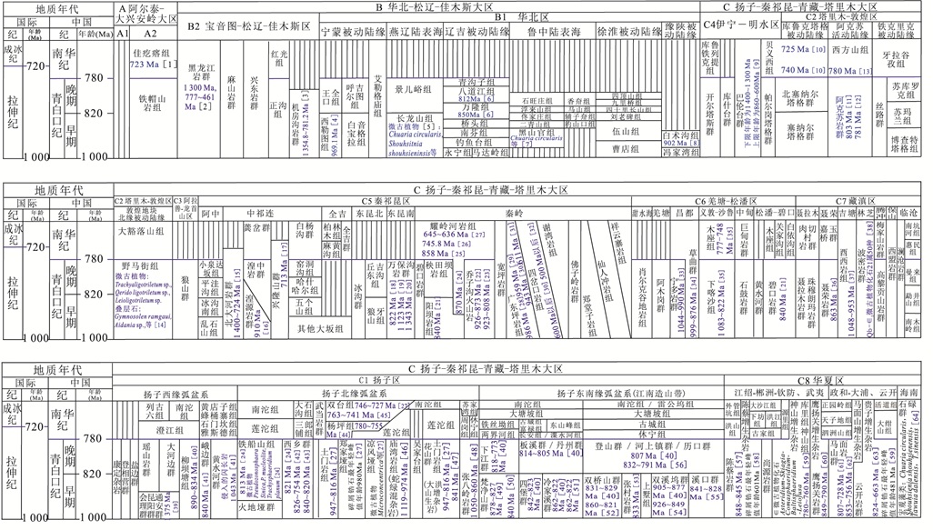
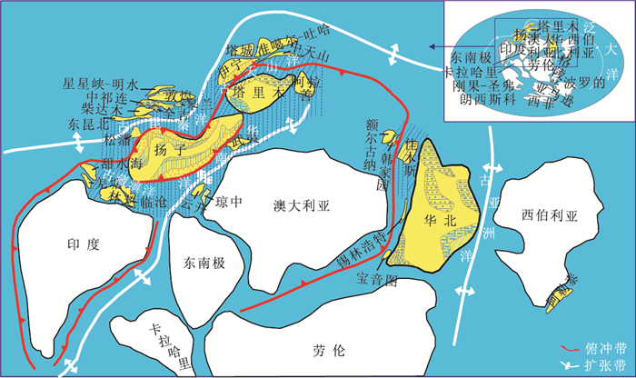
During Early Qingbaikouan Period, Neoproterozoic (1 000-820 Ma), the structural background of global assembly of the Rodinia supercontinent is the key factor on the pattern of ocean and block in China. The three big blocks, North China, Tarim and Yangtze, located in the Northern Hemisphere at that time and were surrounded by marginal sea/ocean. There occurred several passive continental marginal seas at the periphery of the North China block; the Yangtze block was characterized by arc-basin sediments around the western, northern and southeastern margins; it was active continental margin at the Aksu area developed around the northwestern Tarim block, and passive continental margin at the Kuluketage (clast) and at the Tiekelike (carbonate) grew around the nrotheastern and southwestern part of the block, respectively. In the continental marginal sea and ocean surrounding the three blocks, many massifs had a relationship with the Yangtze and Tarim cratons, such as Yining, Dunhuang, Alxa, Songpan, Luoxiao and Wuyi, and so on. A few massifs had been related to the North China and Siberian cratons, such as Baoyintu, Xilinhot, Ergun, Hanjiayuan, Jiamusi and Altay blocks.
During Early Qingbaikouan Period, Neoproterozoic (1 000-820 Ma), the structural background of global assembly of the Rodinia supercontinent is the key factor on the pattern of ocean and block in China. The three big blocks, North China, Tarim and Yangtze, located in the Northern Hemisphere at that time and were surrounded by marginal sea/ocean. There occurred several passive continental marginal seas at the periphery of the North China block; the Yangtze block was characterized by arc-basin sediments around the western, northern and southeastern margins; it was active continental margin at the Aksu area developed around the northwestern Tarim block, and passive continental margin at the Kuluketage (clast) and at the Tiekelike (carbonate) grew around the nrotheastern and southwestern part of the block, respectively. In the continental marginal sea and ocean surrounding the three blocks, many massifs had a relationship with the Yangtze and Tarim cratons, such as Yining, Dunhuang, Alxa, Songpan, Luoxiao and Wuyi, and so on. A few massifs had been related to the North China and Siberian cratons, such as Baoyintu, Xilinhot, Ergun, Hanjiayuan, Jiamusi and Altay blocks.


2018, 43(11): 3853-3872.
doi: 10.3799/dqkx.2018.235
Abstract:
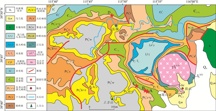
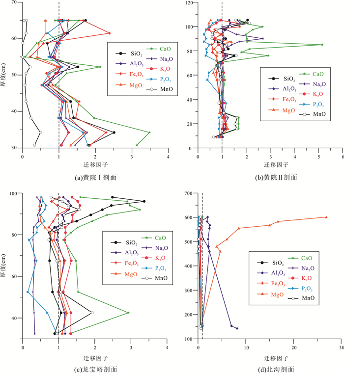
The geochemical composition of regolith can reflect its development processes and the background climatic characteristics of weathering processes, and geochemical compositions of the paleo-regolith formed in earth history can reveal the type of paleo-regolith and record paleoclimatic changes. The record between the Late Neoproterozoic (the Jingeryu Formation) and the Cambrian (the Fujunshan Formation) in North China is a stratigraphic hiatus due to the tectonic uplift and erosion. A typical paleo-regolith widely occurs and is supposed to have recorded paleoclimate changes during the Late Neoproterozoic to Early Cambrian. According to the compositions of major elements, enrichment in elemental migrations and coefficient of weathering distribution of paleo-regolith on the topmost Jingeryu Formation in the Fangshan area, North China, this study suggests that:(1) The major element compositions of the paleo-regolith on the topmost Jingeryu Formation are dominated by the elements of SiO2, Al2O3, TFe2O3, CaO. And the elements of Al2O3, TFe2O3, TiO2, K2O are relatively concentrated in the middle-to-upper parts of the regolith while the SiO2 is slightly lost. (2) The vertical variations of geochemical proxies such as SiO2/Al2O3, SiO2/(Al2O3+TFe2O3), chemical index of alteration (CIA), residual coefficient and BA value indicate that the paleo-regolith should have been formed under a warm and humid condition with moderate chemical weathering. The chemical weathering might have gone through an evolution from weak to strong and again to weak in degree. (3) Compared to the element geochemical characteristics of modern regolith on the topmost carbonate settings from Hunan, Guizhou and Yunnan, it is inferred that the paleo-regolith on the topmost Jingeryu Formation has relatively lower deficiency in Si and enrichment in Fe and Al. Consequently, by comprehensive analysis of the geochemical characteristics of paleo-regolith on the topmost Jingeryu Formation and changes in paleo-latitude of the North China block from the Late Neoproterozoic to the Cambria, it is proposed that the paleo-regolith on the topmost Jingeryu Formation might have been formed under conditions of a warm and humid tropical to subtropical climate siallite-clay regolith.
The geochemical composition of regolith can reflect its development processes and the background climatic characteristics of weathering processes, and geochemical compositions of the paleo-regolith formed in earth history can reveal the type of paleo-regolith and record paleoclimatic changes. The record between the Late Neoproterozoic (the Jingeryu Formation) and the Cambrian (the Fujunshan Formation) in North China is a stratigraphic hiatus due to the tectonic uplift and erosion. A typical paleo-regolith widely occurs and is supposed to have recorded paleoclimate changes during the Late Neoproterozoic to Early Cambrian. According to the compositions of major elements, enrichment in elemental migrations and coefficient of weathering distribution of paleo-regolith on the topmost Jingeryu Formation in the Fangshan area, North China, this study suggests that:(1) The major element compositions of the paleo-regolith on the topmost Jingeryu Formation are dominated by the elements of SiO2, Al2O3, TFe2O3, CaO. And the elements of Al2O3, TFe2O3, TiO2, K2O are relatively concentrated in the middle-to-upper parts of the regolith while the SiO2 is slightly lost. (2) The vertical variations of geochemical proxies such as SiO2/Al2O3, SiO2/(Al2O3+TFe2O3), chemical index of alteration (CIA), residual coefficient and BA value indicate that the paleo-regolith should have been formed under a warm and humid condition with moderate chemical weathering. The chemical weathering might have gone through an evolution from weak to strong and again to weak in degree. (3) Compared to the element geochemical characteristics of modern regolith on the topmost carbonate settings from Hunan, Guizhou and Yunnan, it is inferred that the paleo-regolith on the topmost Jingeryu Formation has relatively lower deficiency in Si and enrichment in Fe and Al. Consequently, by comprehensive analysis of the geochemical characteristics of paleo-regolith on the topmost Jingeryu Formation and changes in paleo-latitude of the North China block from the Late Neoproterozoic to the Cambria, it is proposed that the paleo-regolith on the topmost Jingeryu Formation might have been formed under conditions of a warm and humid tropical to subtropical climate siallite-clay regolith.


2018, 43(11): 3873-3890.
doi: 10.3799/dqkx.2018.143
Abstract:
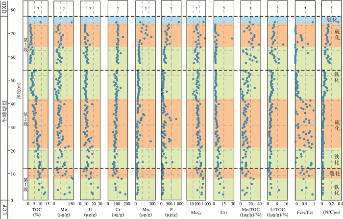
Ediacaran-Cambrian transition is a critical period in Earth history, during which both marine environment and life have experienced drastic changes. It is arguably suggested that pervasive oxygenation and associated geochemical changes in the ocean have potentially driven the rapid diversification of Early Cambrian metazoans, however, the timing and process of ocean oxygenation have not been well constrained. In this paper, an integrated study was conducted on the Lower Cambrian Niutitang (NTT) Fm. in Siduping area, West Hunan and Songjiang Bridge area, East Guizhou, which were paleogeographically situated at the shelf margin-upper slope setting of the Yangtze block. Using ICP-MS, FESEM, EDS and XRD techniques, the abundances and patterns of RSE (redox sensitive elements), pyrite morphology, TOC (total organic carbon), as well as N, P nutrients were investigated systematically. The results show that during NTT deposition, bottom seawaters in the study area experienced a complicated evolution, with a dynamic alternation of 3 ferruginous and 3 euxinic intervals, and suboxic-oxic conditions occurring only at the latest Cambrian Stage 3. Comparison with relevant data published previously from each facies belts within the Yangtze block shows that the seawater oxygenation was a progressive process expanding from shallow water area to deep-water area in time. Platform facies area oxygenated at the late Stage 2, shelf margin area in the late Stage 3, and the deep-water basin kept ferruginous until the latest Stage 3, when it became euxinic. Sediment Mo/TOC, U/TOC ratios increased from bottom to top consecutively in the section, coupled with elevated Cr, Mn, N and P secular trends, likely indicating an overall enhancement of seawater oxygenation. The spatial-temporal distribution and increased paleoecologic complexity of major fossil groups in the Yangtze block over time show a well coincidence with the seawater oxygenation process, likely implying that increased ocean oxygenation and declined euxinic seawaters have facilitated the rapid diversification of Early Cambrian metazoans.
Ediacaran-Cambrian transition is a critical period in Earth history, during which both marine environment and life have experienced drastic changes. It is arguably suggested that pervasive oxygenation and associated geochemical changes in the ocean have potentially driven the rapid diversification of Early Cambrian metazoans, however, the timing and process of ocean oxygenation have not been well constrained. In this paper, an integrated study was conducted on the Lower Cambrian Niutitang (NTT) Fm. in Siduping area, West Hunan and Songjiang Bridge area, East Guizhou, which were paleogeographically situated at the shelf margin-upper slope setting of the Yangtze block. Using ICP-MS, FESEM, EDS and XRD techniques, the abundances and patterns of RSE (redox sensitive elements), pyrite morphology, TOC (total organic carbon), as well as N, P nutrients were investigated systematically. The results show that during NTT deposition, bottom seawaters in the study area experienced a complicated evolution, with a dynamic alternation of 3 ferruginous and 3 euxinic intervals, and suboxic-oxic conditions occurring only at the latest Cambrian Stage 3. Comparison with relevant data published previously from each facies belts within the Yangtze block shows that the seawater oxygenation was a progressive process expanding from shallow water area to deep-water area in time. Platform facies area oxygenated at the late Stage 2, shelf margin area in the late Stage 3, and the deep-water basin kept ferruginous until the latest Stage 3, when it became euxinic. Sediment Mo/TOC, U/TOC ratios increased from bottom to top consecutively in the section, coupled with elevated Cr, Mn, N and P secular trends, likely indicating an overall enhancement of seawater oxygenation. The spatial-temporal distribution and increased paleoecologic complexity of major fossil groups in the Yangtze block over time show a well coincidence with the seawater oxygenation process, likely implying that increased ocean oxygenation and declined euxinic seawaters have facilitated the rapid diversification of Early Cambrian metazoans.


2018, 43(11): 3891-3900.
doi: 10.3799/dqkx.2018.296
Abstract:
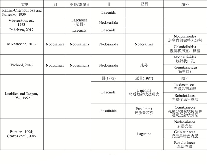
Present status of higher taxonomy based on morphology shows that the American school differs from the Soviet school on major taxonomic characters. Historical origin of higher taxonomic characters of the two schools are tracked and the present foraminiferal morphological classifications are reviewed. The results show that the higher taxonomic characters of the American school derive from the English workers in the mid-late nineteenth century, whereas the characters of the Soviet school are natural results of the application of evolutionary taxonomic methods. The Soviet school applies phylogeny systematically, therefore the higher classifications of which are more soundly based than that of the American school. However, reconstruction of phylogeny of the Soviet school is not scientifically based. Problems in higher taxonomy of Permian nodosarioids will possibly be solved when combining morphological study with molecular phylogenetic and cladistic studies.
Present status of higher taxonomy based on morphology shows that the American school differs from the Soviet school on major taxonomic characters. Historical origin of higher taxonomic characters of the two schools are tracked and the present foraminiferal morphological classifications are reviewed. The results show that the higher taxonomic characters of the American school derive from the English workers in the mid-late nineteenth century, whereas the characters of the Soviet school are natural results of the application of evolutionary taxonomic methods. The Soviet school applies phylogeny systematically, therefore the higher classifications of which are more soundly based than that of the American school. However, reconstruction of phylogeny of the Soviet school is not scientifically based. Problems in higher taxonomy of Permian nodosarioids will possibly be solved when combining morphological study with molecular phylogenetic and cladistic studies.
2018, 43(11): 3901-3909.
doi: 10.3799/dqkx.2018.257
Abstract:
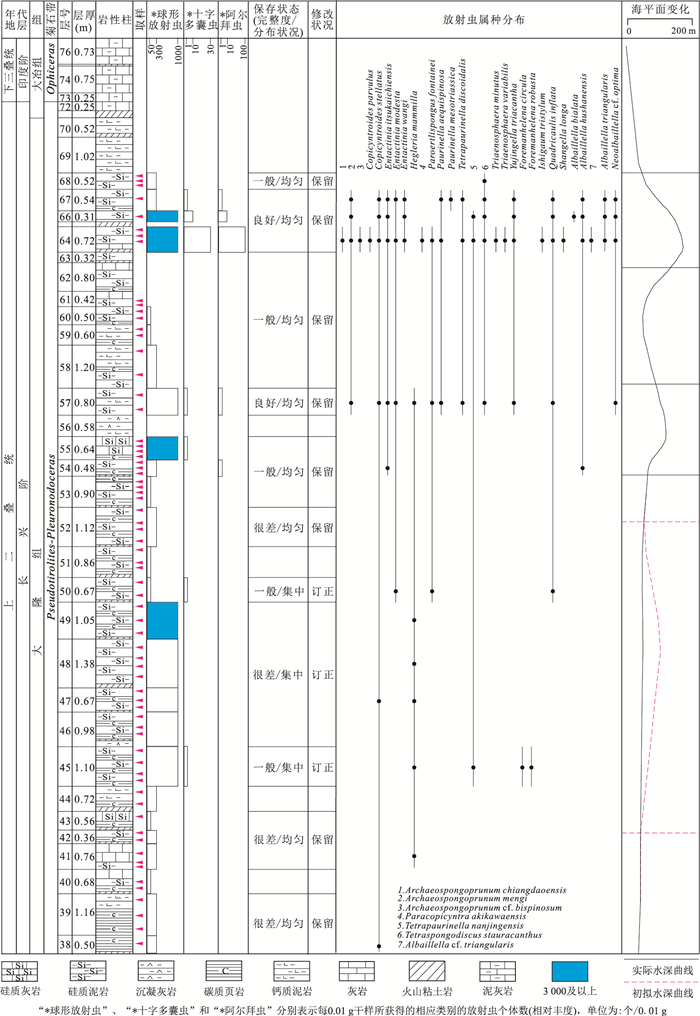
The process of the Paleozoic-Mesozoic mass extinction in different paleogeographic settings is different. The research on radiolarian fauna provides not only important information for the study of paleogeographic settings but also basic information for the study of biodiversity evolution. The research on the radiolarians in the basinal facies of the Permian-Triassic transition is of great significance to reveal the mass extinction among different sedimentary facies and the paleoenvironmental evolution. The Permian-Triassic boundary section of Kejiao, Guizhou Province is located in the northern margin of the Nanpanjiang basin, which is in the basinal facies. In this paper, the preliminary statistics and taxonomy composition of the radiolarians from the Talung Formation and the basal part of Daye Formation in the Kejiao Section Were analyzed. And then the paleo-water depths of the late Changhsingian were studied in detail, based on the statistics and analysis of radiolarians and the preservation of the radiolarians. It is concluded that Talung Formation to basal Daye Formation were deposited below the wave base, and the paleo-water depths are generally considered as shallower than 150 meters. The paleo-water depths during the maximum transgression in the latest Changshingian (equivalent to the uppermost of the Talung Formation) are about/or deeper than 200 meters.
The process of the Paleozoic-Mesozoic mass extinction in different paleogeographic settings is different. The research on radiolarian fauna provides not only important information for the study of paleogeographic settings but also basic information for the study of biodiversity evolution. The research on the radiolarians in the basinal facies of the Permian-Triassic transition is of great significance to reveal the mass extinction among different sedimentary facies and the paleoenvironmental evolution. The Permian-Triassic boundary section of Kejiao, Guizhou Province is located in the northern margin of the Nanpanjiang basin, which is in the basinal facies. In this paper, the preliminary statistics and taxonomy composition of the radiolarians from the Talung Formation and the basal part of Daye Formation in the Kejiao Section Were analyzed. And then the paleo-water depths of the late Changhsingian were studied in detail, based on the statistics and analysis of radiolarians and the preservation of the radiolarians. It is concluded that Talung Formation to basal Daye Formation were deposited below the wave base, and the paleo-water depths are generally considered as shallower than 150 meters. The paleo-water depths during the maximum transgression in the latest Changshingian (equivalent to the uppermost of the Talung Formation) are about/or deeper than 200 meters.


2018, 43(11): 3910-3921.
doi: 10.3799/dqkx.2018.104
Abstract:
As global challenging key issues of paleontology and stratigraphy, the terrestrial Permian-Triassic (P-Tr) stratigraphic subdivision and correlation have great significance for a comprehensive understanding of the nature of the global biotic and environmental event. Here, we try to establish the biostratigraphic correlation framework of the terrestrial depositions, and further explore the correlation between the marine and terrestrial P-Tr depositions, based on the P-Tr transitional mixed marine-terrestrial biota in Weibei area of Shaanxi Province. The present study focuses on the taxonomy, evolutionary lineage and stratigraphy of P-Tr transitional conchostracans (clam shrimps, spinicaudatans) in the terrestrial and terrestrial-marine siliciclastic facies, which are regarded as an intermediate link for biostratigraphic correlation between terrestrial and marine sequences. A total of eight species in four genus and three species in two genus conchostracans were identified in the Shichuanhe Section and Houzhougong miao Section, respectively. Accordingly, in the study it proposes that the conchostracans fauna may be subdivided into three assemblages including the latest Permian Pseudestheria minuta-Pseudestheria xinjiangensis assemblage, the P-Tr transitional Euestheria gutta-Palaeolimnadiopsis vilujensis assemblage and the earliest Triassic Magniestheria subcircularis-Cornia germari assemblage. Especially, the Euestheria gutta-Palaeolimnadiopsis vilujensis assemblage is proposed as marker of the P-Tr transitional beds of the terrestrial strata among various regions.
As global challenging key issues of paleontology and stratigraphy, the terrestrial Permian-Triassic (P-Tr) stratigraphic subdivision and correlation have great significance for a comprehensive understanding of the nature of the global biotic and environmental event. Here, we try to establish the biostratigraphic correlation framework of the terrestrial depositions, and further explore the correlation between the marine and terrestrial P-Tr depositions, based on the P-Tr transitional mixed marine-terrestrial biota in Weibei area of Shaanxi Province. The present study focuses on the taxonomy, evolutionary lineage and stratigraphy of P-Tr transitional conchostracans (clam shrimps, spinicaudatans) in the terrestrial and terrestrial-marine siliciclastic facies, which are regarded as an intermediate link for biostratigraphic correlation between terrestrial and marine sequences. A total of eight species in four genus and three species in two genus conchostracans were identified in the Shichuanhe Section and Houzhougong miao Section, respectively. Accordingly, in the study it proposes that the conchostracans fauna may be subdivided into three assemblages including the latest Permian Pseudestheria minuta-Pseudestheria xinjiangensis assemblage, the P-Tr transitional Euestheria gutta-Palaeolimnadiopsis vilujensis assemblage and the earliest Triassic Magniestheria subcircularis-Cornia germari assemblage. Especially, the Euestheria gutta-Palaeolimnadiopsis vilujensis assemblage is proposed as marker of the P-Tr transitional beds of the terrestrial strata among various regions.


2018, 43(11): 3922-3931.
doi: 10.3799/dqkx.2018.334
Abstract:
Early Triassic oceans recorded the delayed biotic recovery and the large perturbed environments. Hence, the environmental events and their mechanism became one of the key scientific topics for the geological scientists. In recent years, researchers have made many significant progresses in the marine carbon-nitrogen-sulfur cycles of the Early Triassic, which are important for understanding the co-evolution between the biotic recovery and environmental changes. The progress, problem and future development in the researches of carbon-nitrogen-sulfur cycles during the Early Triassic have been reviewed and summarized.
Early Triassic oceans recorded the delayed biotic recovery and the large perturbed environments. Hence, the environmental events and their mechanism became one of the key scientific topics for the geological scientists. In recent years, researchers have made many significant progresses in the marine carbon-nitrogen-sulfur cycles of the Early Triassic, which are important for understanding the co-evolution between the biotic recovery and environmental changes. The progress, problem and future development in the researches of carbon-nitrogen-sulfur cycles during the Early Triassic have been reviewed and summarized.


2018, 43(11): 3932-3946.
doi: 10.3799/dqkx.2018.292
Abstract:
Previous studies indicate that there are Middle Triassic strata in the southern Qiangtang basin, which has not been confirmed due to the lack of solid evidence of paleontological fossils. Here two new sections in Zuoqingcuo, Jimu Town, Gaize County, Tibet, were investigated. It is found that the sections belong to the Upper Triassic Riganpeicuo Formation according to the 1:250 000 Regional Geological Survey Report of Dinggu Area. 33 species in 18 genera of fossil radiolarians from the specimens of siliceous rocks were totally obtained and identified. The main components of the radiolarians are Cryptostephanidium longispinosum (Sashida), Eptingium manfredi Dumitrica, Falcispongus falciformis Dumitrica, Hindeosphaera spinulosa (Nakaseko et Nishimura), Muelleritortis firmum (Gorican), Oertlispongus inaequispinosus Dumitrica, Kozur et Mostler, Paroertlispongus chinensis (Feng), Paroertlispongus hermi (Lahm), Paroertlispongus weddigei Lahm, Paurinella aequispinosa Kozur et Mostler, Pseudostylosphaera coccostyla (Rüst), Pseudostylosphaera compacta (Nakaseko et Nishimura), Pseudostylosphaera gracilis Kozur et Mostler, Pseudostylosphaera japonica (Nakaseko et Nishimura), Pseudostylosphaera nazarovi (Kozur et Mostler), Pseudostylosphaera tenue Nakaseko et Nishimura), Triassocampe imitata Bragin, Triassospongosphaera triassica (Kozur et Mostler). The radiolarian assemblage indicates an age of the late Anisian-early Ladinian of Middle Triassic for the two sections. Based on the previous research and the present data, the Triassic strata in the southern Qiangtang basin are divided into (1) the Lower Triassic Zishisang Formation, indicating carbonate deposition in a stable shallow marine environment, (2) the Middle Triassic Zuoqingcuo Formation, a new formation, indicating clasolite to silicolite deposition in a deep-water (bathyal-abyssal) environment, (3) the Upper Triassic Riganpeicuo Formation and the Upper Triassic-Lower Jurassic Samenxiong Formation. Our results provide stratigraphic and paleontological evidences to understand the features and contents of the Middle Triassic in the southern Qiangtang area, and also further confirm that the Middle Triassic of the southern Qiangtang basin was not an erosional or uplift area, but a bathyal-abyssal depositional area.
Previous studies indicate that there are Middle Triassic strata in the southern Qiangtang basin, which has not been confirmed due to the lack of solid evidence of paleontological fossils. Here two new sections in Zuoqingcuo, Jimu Town, Gaize County, Tibet, were investigated. It is found that the sections belong to the Upper Triassic Riganpeicuo Formation according to the 1:250 000 Regional Geological Survey Report of Dinggu Area. 33 species in 18 genera of fossil radiolarians from the specimens of siliceous rocks were totally obtained and identified. The main components of the radiolarians are Cryptostephanidium longispinosum (Sashida), Eptingium manfredi Dumitrica, Falcispongus falciformis Dumitrica, Hindeosphaera spinulosa (Nakaseko et Nishimura), Muelleritortis firmum (Gorican), Oertlispongus inaequispinosus Dumitrica, Kozur et Mostler, Paroertlispongus chinensis (Feng), Paroertlispongus hermi (Lahm), Paroertlispongus weddigei Lahm, Paurinella aequispinosa Kozur et Mostler, Pseudostylosphaera coccostyla (Rüst), Pseudostylosphaera compacta (Nakaseko et Nishimura), Pseudostylosphaera gracilis Kozur et Mostler, Pseudostylosphaera japonica (Nakaseko et Nishimura), Pseudostylosphaera nazarovi (Kozur et Mostler), Pseudostylosphaera tenue Nakaseko et Nishimura), Triassocampe imitata Bragin, Triassospongosphaera triassica (Kozur et Mostler). The radiolarian assemblage indicates an age of the late Anisian-early Ladinian of Middle Triassic for the two sections. Based on the previous research and the present data, the Triassic strata in the southern Qiangtang basin are divided into (1) the Lower Triassic Zishisang Formation, indicating carbonate deposition in a stable shallow marine environment, (2) the Middle Triassic Zuoqingcuo Formation, a new formation, indicating clasolite to silicolite deposition in a deep-water (bathyal-abyssal) environment, (3) the Upper Triassic Riganpeicuo Formation and the Upper Triassic-Lower Jurassic Samenxiong Formation. Our results provide stratigraphic and paleontological evidences to understand the features and contents of the Middle Triassic in the southern Qiangtang area, and also further confirm that the Middle Triassic of the southern Qiangtang basin was not an erosional or uplift area, but a bathyal-abyssal depositional area.


2018, 43(11): 3947-3954.
doi: 10.3799/dqkx.2018.144
Abstract:
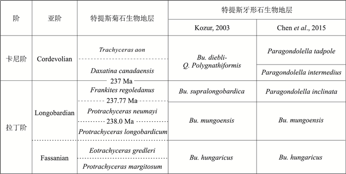
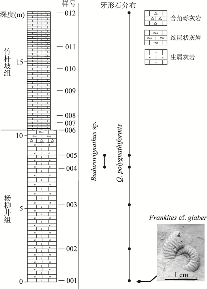
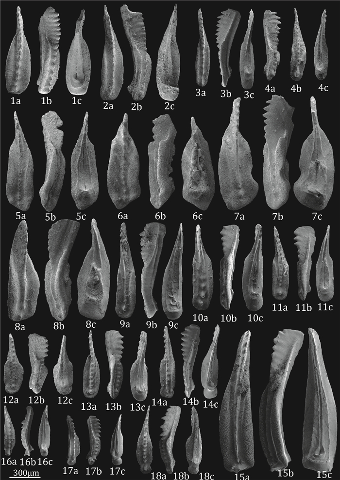
The Global Boundary Stratotype Section and Point (GSSP) for Ladinian-Carnian Boundary (LCB) was defined at Prati Di Stuores/Stuores Wiesen Section in Italy at a level coinciding with the lowest occurrence of the ammonoid Daxatina canadensis. This GSSP level is commonly considered to near the lowest occurrence of the conodonts Quadralella polygnathiformis or Budurovignathus diebeli. However, the placement of the LCB within sections of South China is controversial, because the primary ammonoid marker for LCB (D. canadensis) hasn't been reported in South China. The working placement of LCB based on ammonoid biostratigraphy (e.g., Trachyceras) is considerably higher than the levels where the conodont biostratigraphy would suggest its position. For example, ammonoids in the southwest Guizhou region with the best marine record in South China suggest the LCB should be assigned near the top of Zhuganpo Formation, whereas conodont biostratigraphy suggests that the LCB should be at the base of Zhuganpo Fm.. The Dapingzi Section in Zhenfeng County of Guizhou Province, yielded elements of the conodonts Quadralella polygnathiformis and Budurovignathus sp. from the transitional bed near the top of Yangliujing Formation, which suggests an assignment to the lowermost Carnian (the "Cordevolian" substage, as used by some authors). Therefore, this conodont assemblage would imply that the LCB in the Dapingzi Section should be placed within the upper part of Yangliujing Formation, below the base of the Zhuganpo Formation. However, to accurately assign the LCB within the marine deposits of South China requires integrating the ammonoid and conodont biostratigraphy with additional stratigraphic correlation methods, such as magnetostratigraphy and U/Pb ages.
The Global Boundary Stratotype Section and Point (GSSP) for Ladinian-Carnian Boundary (LCB) was defined at Prati Di Stuores/Stuores Wiesen Section in Italy at a level coinciding with the lowest occurrence of the ammonoid Daxatina canadensis. This GSSP level is commonly considered to near the lowest occurrence of the conodonts Quadralella polygnathiformis or Budurovignathus diebeli. However, the placement of the LCB within sections of South China is controversial, because the primary ammonoid marker for LCB (D. canadensis) hasn't been reported in South China. The working placement of LCB based on ammonoid biostratigraphy (e.g., Trachyceras) is considerably higher than the levels where the conodont biostratigraphy would suggest its position. For example, ammonoids in the southwest Guizhou region with the best marine record in South China suggest the LCB should be assigned near the top of Zhuganpo Formation, whereas conodont biostratigraphy suggests that the LCB should be at the base of Zhuganpo Fm.. The Dapingzi Section in Zhenfeng County of Guizhou Province, yielded elements of the conodonts Quadralella polygnathiformis and Budurovignathus sp. from the transitional bed near the top of Yangliujing Formation, which suggests an assignment to the lowermost Carnian (the "Cordevolian" substage, as used by some authors). Therefore, this conodont assemblage would imply that the LCB in the Dapingzi Section should be placed within the upper part of Yangliujing Formation, below the base of the Zhuganpo Formation. However, to accurately assign the LCB within the marine deposits of South China requires integrating the ammonoid and conodont biostratigraphy with additional stratigraphic correlation methods, such as magnetostratigraphy and U/Pb ages.

2018, 43(11): 3955-3975.
doi: 10.3799/dqkx.2018.248
Abstract:
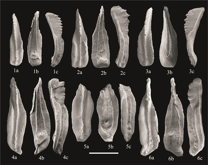
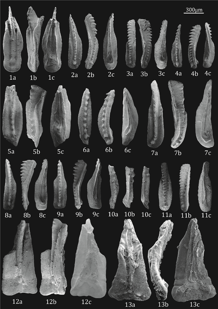
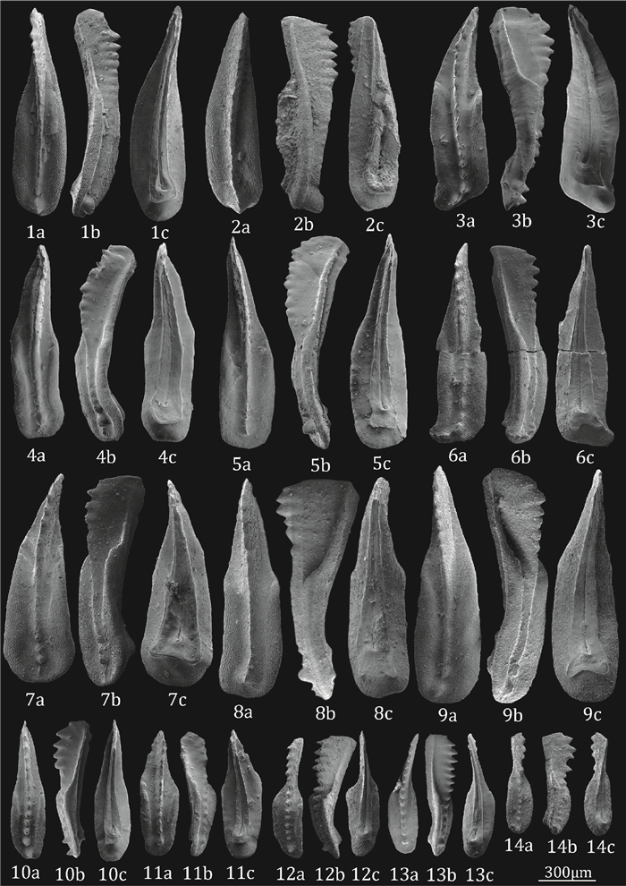
Marine depositions in Southwest China were well developed during the Middle to Upper Triassic. However, conodont biostratigraphic subdivision and correlation in the Late Triassic (Carnian age) are less systematically studied. Based on high-precision conodont samples collected from Yangliujing, Zhuganpo and Wayao formations in Luoping, Guanling and Zhenfeng counties, detailed conodont biostrtagraphic and systematic taxonomy researches were conducted, and twenty three species and three genera were recongnized. Eight conodont zones were established, they are, in ascending order, the Paragondolella foliata zone, the Quadralella polygnathiformis zone, the Quadralella tadpole zone, the Quadralella praelindae zone, the Quadralella aff. auriformis zone, the Quadralella robusta zone, the Quadralella noah zone and the Quadralella ex gr. carpathica zone. Based on the published and obtained materials, a further discussion on conodont biostratigraphic subdivision and regional correlation in area and realm and conodont evolution are also presented in this study.
Marine depositions in Southwest China were well developed during the Middle to Upper Triassic. However, conodont biostratigraphic subdivision and correlation in the Late Triassic (Carnian age) are less systematically studied. Based on high-precision conodont samples collected from Yangliujing, Zhuganpo and Wayao formations in Luoping, Guanling and Zhenfeng counties, detailed conodont biostrtagraphic and systematic taxonomy researches were conducted, and twenty three species and three genera were recongnized. Eight conodont zones were established, they are, in ascending order, the Paragondolella foliata zone, the Quadralella polygnathiformis zone, the Quadralella tadpole zone, the Quadralella praelindae zone, the Quadralella aff. auriformis zone, the Quadralella robusta zone, the Quadralella noah zone and the Quadralella ex gr. carpathica zone. Based on the published and obtained materials, a further discussion on conodont biostratigraphic subdivision and regional correlation in area and realm and conodont evolution are also presented in this study.


2018, 43(11): 3976-3988.
doi: 10.3799/dqkx.2018.333
Abstract:
Pigs were domesticated from wild boars by humans living in different parts of the world. Archaeological studies show that the Near East and China may be the domestication centers of pigs. In order to find evidence for the genetic contribution of wild boars to pig domestication, ancient DNA study on 30 Late Pleistocene wild boar fossils collected from three caves in Guangxi, southern China was conducted. Through the use of the fragmented D-loop sequences and the homologous sequences of wild boars and domestic pigs across Asia and Europe, the network figure and phylogenetic trees of Suidae were reconstructed. The results show that the existence of historical gene flow between ancient Guangxi wild boars and European pigs, and there is a genetic continuity from ancient Guangxi wild boars to Asian domestic pigs, which suggests a genetic contribution of ancient wild boars to the pig domestication. Therefore, this study provides new molecular evidence of multiple and independent events for pig domestication in terms of geographic region.
Pigs were domesticated from wild boars by humans living in different parts of the world. Archaeological studies show that the Near East and China may be the domestication centers of pigs. In order to find evidence for the genetic contribution of wild boars to pig domestication, ancient DNA study on 30 Late Pleistocene wild boar fossils collected from three caves in Guangxi, southern China was conducted. Through the use of the fragmented D-loop sequences and the homologous sequences of wild boars and domestic pigs across Asia and Europe, the network figure and phylogenetic trees of Suidae were reconstructed. The results show that the existence of historical gene flow between ancient Guangxi wild boars and European pigs, and there is a genetic continuity from ancient Guangxi wild boars to Asian domestic pigs, which suggests a genetic contribution of ancient wild boars to the pig domestication. Therefore, this study provides new molecular evidence of multiple and independent events for pig domestication in terms of geographic region.


2018, 43(11): 3989-4000.
doi: 10.3799/dqkx.2018.324
Abstract:
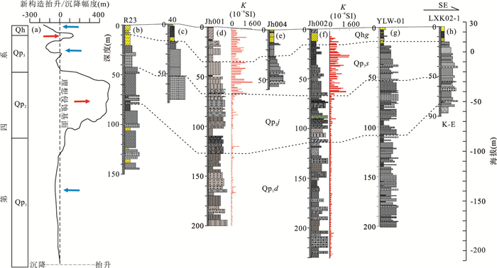
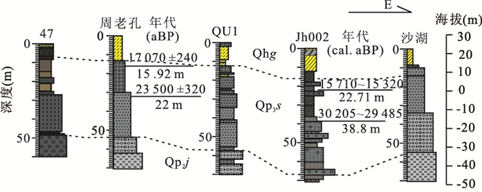
In order to explore the further relationship among the Quaternary neotectonic movement, climate change and sedimentary response in the Jianghan basin, a systematic study of lithology, geochronology and sedimentology was carried out using typical Quaternary boreholes in the Mianyang depression in the eastern part of the basin. A comparable sequence of Quaternary borehole strata was first established in the deposition center of the eastern Jianghan basin. A complete sedimentary evolution history of the river facies, alternation of river and lacustrine facies, lacustrine facies, alternation of river and lacustrine facies, lacustrine facies and floodplain facies was reconstructed in turn in the past 140 ka based on lithology, grain size and magnetic fabric analysis. The integrated analysis of regional tectonic movement, sedimentary evolution and climatic change shows that there occurred 3 periods of lacustrine deposition including the transition of Qp2/Qp1, Qp3, and mid-late Holocene (ancient Yunmeng lakes), respectively. Our results demonstrate that the development of paleolake since the MIS3 is related to the coupling of neotectonic subsidence and extremely strong summer monsoon. The unique environment of lacustrine deposition provides important material conditions for the formation of high-arsenic groundwater in the basin. This study not only provides reliable basic data for the stratigraphic division and correlation of Quaternary boreholes in the Jianghan basin, but also provides an important reference for underground resources investigation and environmental planning and protection.
In order to explore the further relationship among the Quaternary neotectonic movement, climate change and sedimentary response in the Jianghan basin, a systematic study of lithology, geochronology and sedimentology was carried out using typical Quaternary boreholes in the Mianyang depression in the eastern part of the basin. A comparable sequence of Quaternary borehole strata was first established in the deposition center of the eastern Jianghan basin. A complete sedimentary evolution history of the river facies, alternation of river and lacustrine facies, lacustrine facies, alternation of river and lacustrine facies, lacustrine facies and floodplain facies was reconstructed in turn in the past 140 ka based on lithology, grain size and magnetic fabric analysis. The integrated analysis of regional tectonic movement, sedimentary evolution and climatic change shows that there occurred 3 periods of lacustrine deposition including the transition of Qp2/Qp1, Qp3, and mid-late Holocene (ancient Yunmeng lakes), respectively. Our results demonstrate that the development of paleolake since the MIS3 is related to the coupling of neotectonic subsidence and extremely strong summer monsoon. The unique environment of lacustrine deposition provides important material conditions for the formation of high-arsenic groundwater in the basin. This study not only provides reliable basic data for the stratigraphic division and correlation of Quaternary boreholes in the Jianghan basin, but also provides an important reference for underground resources investigation and environmental planning and protection.


2018, 43(11): 4001-4007.
doi: 10.3799/dqkx.2018.575
Abstract:
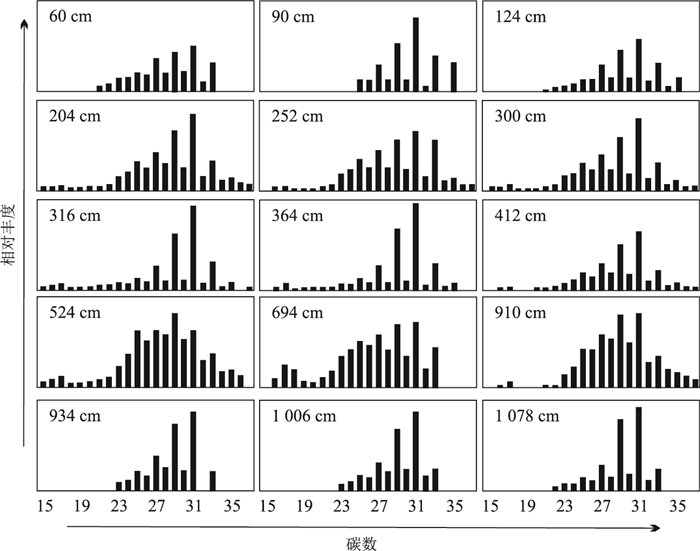
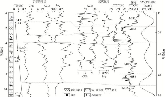
It is of importance to reconstruct the paleoclimatic variations since late Pleistocene in North China. In this paper, it selected Ningjinpo area to characterize the paleoclimatic oscillations with the aid of microbial lipids. Results indicate that the carbon number distributions of most samples ranged from C15 to C33, with the dominance of high carbon (C29 and C31 in particular) in most samples and some lower homologue as secondary peak (C17 for instance), suggesting the mixed origin from higher plants and aquatic organisms. According to the parameters derived from n-alkanes, alternative paleoclimatic conditions of the study area from warm climate with low lake level (83-68 ka), hot-wet period with lake expansion (68-30 ka), cold-dry duration with shrinking lake (30-22 ka), hot and wet climate with increasing lake level (22-10 ka), to moderate climate period (10-0 ka) were reconstructed since late Pleistocene. Regional comparison demonstrated the similar glacial-interglacial paleoclimatic patterns occurred in Ningjinpo area and Yanqing basin, potentially suggesting the principal control of solar radiation.
It is of importance to reconstruct the paleoclimatic variations since late Pleistocene in North China. In this paper, it selected Ningjinpo area to characterize the paleoclimatic oscillations with the aid of microbial lipids. Results indicate that the carbon number distributions of most samples ranged from C15 to C33, with the dominance of high carbon (C29 and C31 in particular) in most samples and some lower homologue as secondary peak (C17 for instance), suggesting the mixed origin from higher plants and aquatic organisms. According to the parameters derived from n-alkanes, alternative paleoclimatic conditions of the study area from warm climate with low lake level (83-68 ka), hot-wet period with lake expansion (68-30 ka), cold-dry duration with shrinking lake (30-22 ka), hot and wet climate with increasing lake level (22-10 ka), to moderate climate period (10-0 ka) were reconstructed since late Pleistocene. Regional comparison demonstrated the similar glacial-interglacial paleoclimatic patterns occurred in Ningjinpo area and Yanqing basin, potentially suggesting the principal control of solar radiation.

2018, 43(11): 4036-4045.
doi: 10.3799/dqkx.2018.599
Abstract:
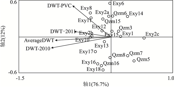
Ecological monitoring is a key way to understand the processes and dynamics of the response, evolution and function of peatlands in the changing climate, and an internal need for protection, management and ecological restoration of wetlands ecosystem. Testate amoebae are a group of unicellular protists widely distributed in nearly all kinds of habitats, especially in Sphagnum peatlands, which have been widely used as environmental indicators for paleoecological change. PVC (discoloration of polyvinyl chloride) tape was used to monitoring the water level in peatland. Here, investigateld the diversity and abundance of testate amoebae in the subalpine peatlands of West Hubei Province were investigateld. A total of 27 species belonging to 14 genera were identified. The ordination by Redundancy analysis (RDA) implies that the moisture/hydrological conditions (indicated by depth to water table, DWT) are the controlling factors of the testate amoeba community composition. A testate amoebae-based hydrological transfer function is developed, which can be used for the Holocene hydrological reconstruction in peatlands of the region.
Ecological monitoring is a key way to understand the processes and dynamics of the response, evolution and function of peatlands in the changing climate, and an internal need for protection, management and ecological restoration of wetlands ecosystem. Testate amoebae are a group of unicellular protists widely distributed in nearly all kinds of habitats, especially in Sphagnum peatlands, which have been widely used as environmental indicators for paleoecological change. PVC (discoloration of polyvinyl chloride) tape was used to monitoring the water level in peatland. Here, investigateld the diversity and abundance of testate amoebae in the subalpine peatlands of West Hubei Province were investigateld. A total of 27 species belonging to 14 genera were identified. The ordination by Redundancy analysis (RDA) implies that the moisture/hydrological conditions (indicated by depth to water table, DWT) are the controlling factors of the testate amoeba community composition. A testate amoebae-based hydrological transfer function is developed, which can be used for the Holocene hydrological reconstruction in peatlands of the region.


2018, 43(11): 4056-4065.
doi: 10.3799/dqkx.2018.289
Abstract:
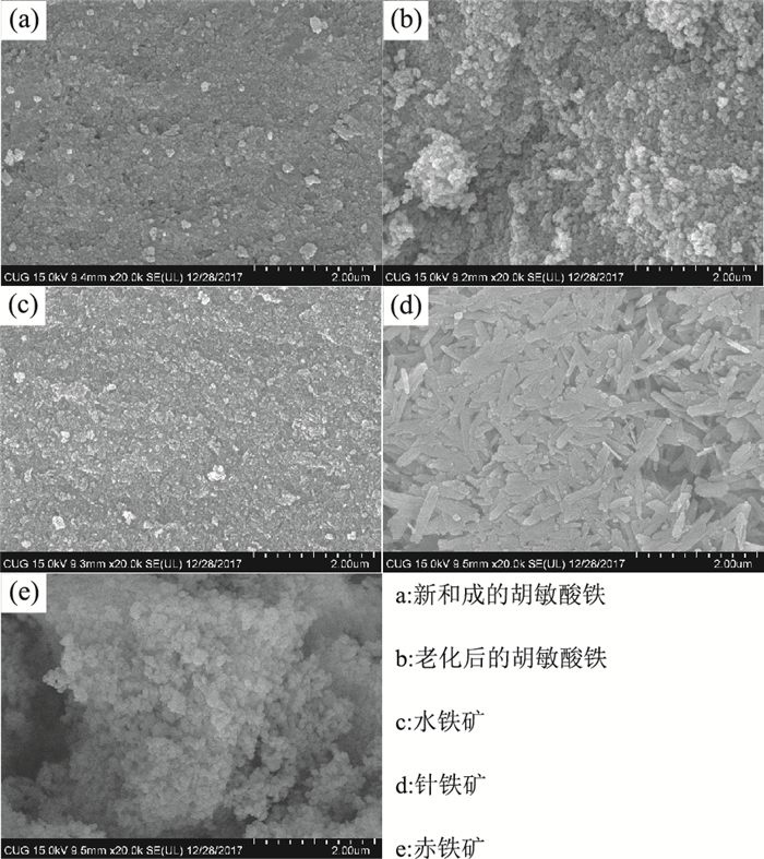
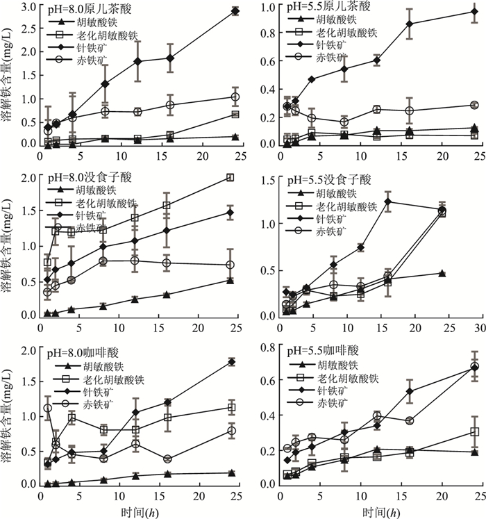
Peatland is a type of wetland with global significance, and the study of the dissolution of phenolic-iron complexes by peat derived phenolic acids helps us to understand better the iron-carbon coupled geochemical cycle. In this study, humic substances were extracted from Jingchuan peatland soils and hematite, goethite, ferrihydrite and Fe-organic associations were synthesized. After that, a series of dissolution experiments were performed with three representative peatland-derived phenolic acids, including gallic acid, caffeic acid and protocatechuic acid. Results show that the amorphous ferrihydrite and the newly synthesized humic-Fe have weaker dissolution capacities, but the well-crystallized goethite, hematite and the humic-Fe after aging have better dissolution capacities, meanwhile the humic-Fe could be more stable in the phenolic acids solution than the pure iron oxides. It is confirmed that the organic iron makes up higher proportion in peatland soil, while the crystallized iron oxides make up higher proportion in mineral soils. The interaction between iron and carbon in peatland is complicated, where iron could be exported to aquatic ecosystem such as the ocean by complexing with iron, and organic carbon could also be preserved by forming Fe-organic complexes, thus affecting the global iron-carbon coupled geochemical cycle.
Peatland is a type of wetland with global significance, and the study of the dissolution of phenolic-iron complexes by peat derived phenolic acids helps us to understand better the iron-carbon coupled geochemical cycle. In this study, humic substances were extracted from Jingchuan peatland soils and hematite, goethite, ferrihydrite and Fe-organic associations were synthesized. After that, a series of dissolution experiments were performed with three representative peatland-derived phenolic acids, including gallic acid, caffeic acid and protocatechuic acid. Results show that the amorphous ferrihydrite and the newly synthesized humic-Fe have weaker dissolution capacities, but the well-crystallized goethite, hematite and the humic-Fe after aging have better dissolution capacities, meanwhile the humic-Fe could be more stable in the phenolic acids solution than the pure iron oxides. It is confirmed that the organic iron makes up higher proportion in peatland soil, while the crystallized iron oxides make up higher proportion in mineral soils. The interaction between iron and carbon in peatland is complicated, where iron could be exported to aquatic ecosystem such as the ocean by complexing with iron, and organic carbon could also be preserved by forming Fe-organic complexes, thus affecting the global iron-carbon coupled geochemical cycle.


2018, 43(11): 4109-4119.
doi: 10.3799/dqkx.2018.177
Abstract:
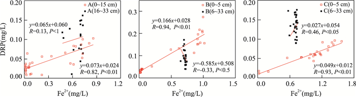
To find out distribution and coupling pattern of iron and phosphorus, as well as impact on phosphorus release in microenvironment of intertidal region. with the help of diffusive gradients in thin films technique (ZrO-Chelex DGT), we obtained in-situ high-resolution DRP and Fe2+ concentrations in porewater profiles of mangrove tidal flat in Jiulong River estuary, as well as the corresponding sediment properties in this study. The results show:(1) In surface porewater, the remarkable positive correlation between DRP and Fe2+ verified the coupling relationship of these two elements and the crucial effects of sediment iron (Ⅲ) (oxyhydr) oxides on the absorption/desorption of phosphorus; (2) in deep anoxic porewater, on account of sediment heterogeneity and absorption by mangrove plants, DRP concentrations presented obvious fluctuations compared with Fe2+; (3) the molecular diffusion flux was estimated ranging from 0.000 64 to 0.006 00 μg·cm-2·d-1 based on DRP concentrations gradient in surface porewater, which are much lower than results of general lake research. The main reason is P-Fe coupling in this iron-rich tidal flat sediment with deep oxidation zone which effectively restrains phosphorus release.
To find out distribution and coupling pattern of iron and phosphorus, as well as impact on phosphorus release in microenvironment of intertidal region. with the help of diffusive gradients in thin films technique (ZrO-Chelex DGT), we obtained in-situ high-resolution DRP and Fe2+ concentrations in porewater profiles of mangrove tidal flat in Jiulong River estuary, as well as the corresponding sediment properties in this study. The results show:(1) In surface porewater, the remarkable positive correlation between DRP and Fe2+ verified the coupling relationship of these two elements and the crucial effects of sediment iron (Ⅲ) (oxyhydr) oxides on the absorption/desorption of phosphorus; (2) in deep anoxic porewater, on account of sediment heterogeneity and absorption by mangrove plants, DRP concentrations presented obvious fluctuations compared with Fe2+; (3) the molecular diffusion flux was estimated ranging from 0.000 64 to 0.006 00 μg·cm-2·d-1 based on DRP concentrations gradient in surface porewater, which are much lower than results of general lake research. The main reason is P-Fe coupling in this iron-rich tidal flat sediment with deep oxidation zone which effectively restrains phosphorus release.


2018, 43(11): 4120-4127.
doi: 10.3799/dqkx.2018.512
Abstract:
N-alkanes in lacustrine sediments could be well preserved and have documented the paleoenvironmental variations. By the aid of GC method, n-alkanes were identified in lacustrine sediments from Fugaoying profile within Yanqing basin of Beijing, one of the core regions in the North China plain, to characterize the paleoclimatic variations in this area. The results show that the n-alkanes with carbon numbers ranging from C16 to C33 exhibit different distribution patterns. Most samples show a single peak with high carbons (C29 or C31 in particular) and have an odd carbon number predominance, while a few have double peaks with lower and high carbons. The middle and short n-alkanes have no obvious carbon number characteristics. The results suggest the organic origin from terrestrial, some algae and few aquatic plants. According to ESR sequence, organic carbon isotope, ACL (average chain length), CPI (carbon preference index), and Paq, alternative paleoclimatic conditions have been reconstructed in the study area since 56.8 ka. From 56.8 to 45.6 ka, the pretty hot-humid climate results in a higher lake level. During 45.6 and 31.5 ka, the climate became warm and humid, producing a slightly declined lake level. After that, cold-dry climate and seriously declined lake level were distinct between 31.5 and 20.0 ka. From 20.0 to 13.4 ka, the climate was cold and dry, but with a warming trend. During 13.4 to 9.2 ka, the climate became warm slightly and the resulted lake level was lower. Since 9.2 ka, the climate became dry, thus leading to a shrunken lake. Distribution of n-alkanes indicates that the paleoclimatic changes of Yanqing basin are basically parallel to summer solar radiation, grain size of Lijiayuan profile, and oxygen isotope records in Guliya core and Sulu Sea, potentially suggesting the control of solar radiation.
N-alkanes in lacustrine sediments could be well preserved and have documented the paleoenvironmental variations. By the aid of GC method, n-alkanes were identified in lacustrine sediments from Fugaoying profile within Yanqing basin of Beijing, one of the core regions in the North China plain, to characterize the paleoclimatic variations in this area. The results show that the n-alkanes with carbon numbers ranging from C16 to C33 exhibit different distribution patterns. Most samples show a single peak with high carbons (C29 or C31 in particular) and have an odd carbon number predominance, while a few have double peaks with lower and high carbons. The middle and short n-alkanes have no obvious carbon number characteristics. The results suggest the organic origin from terrestrial, some algae and few aquatic plants. According to ESR sequence, organic carbon isotope, ACL (average chain length), CPI (carbon preference index), and Paq, alternative paleoclimatic conditions have been reconstructed in the study area since 56.8 ka. From 56.8 to 45.6 ka, the pretty hot-humid climate results in a higher lake level. During 45.6 and 31.5 ka, the climate became warm and humid, producing a slightly declined lake level. After that, cold-dry climate and seriously declined lake level were distinct between 31.5 and 20.0 ka. From 20.0 to 13.4 ka, the climate was cold and dry, but with a warming trend. During 13.4 to 9.2 ka, the climate became warm slightly and the resulted lake level was lower. Since 9.2 ka, the climate became dry, thus leading to a shrunken lake. Distribution of n-alkanes indicates that the paleoclimatic changes of Yanqing basin are basically parallel to summer solar radiation, grain size of Lijiayuan profile, and oxygen isotope records in Guliya core and Sulu Sea, potentially suggesting the control of solar radiation.


2018, 43(11): 4128-4137.
doi: 10.3799/dqkx.2018.228
Abstract:
The carbonate in loess deposit records the pedogenic environment, especially the moisture information, and can be used to qualitatively and/or quantitatively reconstruct paleoclimate. The δ18O values of the pedogenic carbonate in loess of LGM and Early Holocene, from Ledu (northeastern Tibetan plateau), Northeast China and Bayanbulak basin in Xingjiang, were measured. It showns that the δ18O values of the pedogenic carbonate in loess of LGM and Early Holocene from northeastern Tibetan plateau are -1.38 ‰ and -5.58 ‰, which are 5.74‰ and 1.54‰ respectively higher than the theoretical values of δ18O under the condition of modern monsoon climate. However, the temperature difference was not enough to cause this significant magnitude change of the δ18O values in the pedogenic carbonate. Compared with that in East Asian monsoon region including the Chinese Loess plateau and the Northeast China, the values of the δ18O of the pedogenic carbonate in loess from Ledu during LGM and the Early Holocene are ~2.0‰-6.2‰ higher obviously, but similar to those in the westerly regions such as Xinjiang. The distribution characteristics and spatial differences of the δ18O values of the pedogenic carbonate in loess in different periods may reflect that the East Asian summer monsoon was not the controlling factor of the precipitation during the LGM and early Holocene in the northeastern Tibetan plateau (NETP), while the westerly rainfall and/or local vapor evaporation cycle had an important impact in this period. The climate changing from dry and cold to warm and humid, with higher temperature but less evaporation, could be the reason for the gradual decrease of the δ18O values of the pedogenic carbonate in the loess from LGM to Early Holocene in NETP. The δ18O values of the pedogenic carbonate in the loess from different climatic zones (NETP, the East Asian monsoon region and the westerly zone), revealed by limited data in this study, are significantly different, with which climatic indication is worth further investigation.
The carbonate in loess deposit records the pedogenic environment, especially the moisture information, and can be used to qualitatively and/or quantitatively reconstruct paleoclimate. The δ18O values of the pedogenic carbonate in loess of LGM and Early Holocene, from Ledu (northeastern Tibetan plateau), Northeast China and Bayanbulak basin in Xingjiang, were measured. It showns that the δ18O values of the pedogenic carbonate in loess of LGM and Early Holocene from northeastern Tibetan plateau are -1.38 ‰ and -5.58 ‰, which are 5.74‰ and 1.54‰ respectively higher than the theoretical values of δ18O under the condition of modern monsoon climate. However, the temperature difference was not enough to cause this significant magnitude change of the δ18O values in the pedogenic carbonate. Compared with that in East Asian monsoon region including the Chinese Loess plateau and the Northeast China, the values of the δ18O of the pedogenic carbonate in loess from Ledu during LGM and the Early Holocene are ~2.0‰-6.2‰ higher obviously, but similar to those in the westerly regions such as Xinjiang. The distribution characteristics and spatial differences of the δ18O values of the pedogenic carbonate in loess in different periods may reflect that the East Asian summer monsoon was not the controlling factor of the precipitation during the LGM and early Holocene in the northeastern Tibetan plateau (NETP), while the westerly rainfall and/or local vapor evaporation cycle had an important impact in this period. The climate changing from dry and cold to warm and humid, with higher temperature but less evaporation, could be the reason for the gradual decrease of the δ18O values of the pedogenic carbonate in the loess from LGM to Early Holocene in NETP. The δ18O values of the pedogenic carbonate in the loess from different climatic zones (NETP, the East Asian monsoon region and the westerly zone), revealed by limited data in this study, are significantly different, with which climatic indication is worth further investigation.

2018, 43(11): 4138-4148.
doi: 10.3799/dqkx.2018.614
Abstract:
Bashang area of Hebei Province is located in the East Asian monsoon-margin region and the ecotone between agriculture and animal husbandry. East Asian monsoon variability significantly affects the development of human civilization within its area of influence. In order to reconstruct the climate changes in Bashang area and understand the interactions between past climate and human civilization, a continuous 120 cm sediment profile was recovered from Anguli-Nuur Lake based on phytolith and pollen analysis. The results show that the climate in this region was gradually becoming cold and dry during the last 5 000 years, which is related to the weakening of East Asian monsoon produced by gradual variations of solar radiation. However, the climate was relatively wet during the periods of 5 030-3 074 cal. a BP. On the centennial scale, Anguli-Nuur has experienced seven obvious cold and dry events, which occurred during ~4 500 cal. a BP, 4 100-3 800 cal. a BP, ~3 500 cal. a BP, ~3 000 cal. a BP, ~2 100 cal. a BP, ~1 100 cal. a BP and 800-270 cal. a BP. The cold and dry events are consistent with the weakening stage of East Asian monsoon that is probably affected by high latitude climate and the solar activities. In this region, the development of human civilization is sensitive to climate change. Agriculture civilization is relatively developed during warm and humid stage, and grassland civilization appears during cool and arid stage.
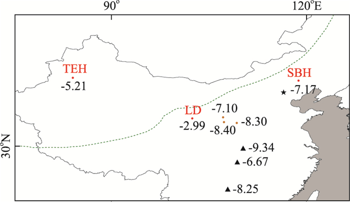
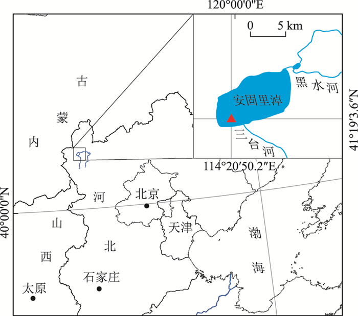
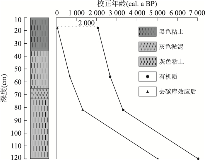
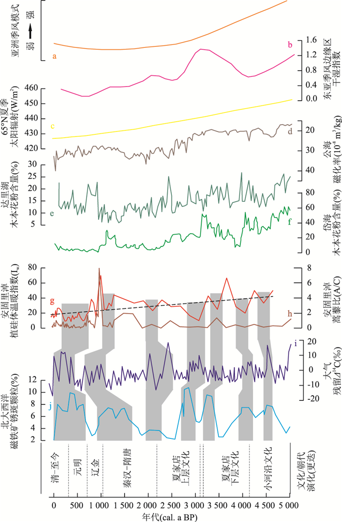
Bashang area of Hebei Province is located in the East Asian monsoon-margin region and the ecotone between agriculture and animal husbandry. East Asian monsoon variability significantly affects the development of human civilization within its area of influence. In order to reconstruct the climate changes in Bashang area and understand the interactions between past climate and human civilization, a continuous 120 cm sediment profile was recovered from Anguli-Nuur Lake based on phytolith and pollen analysis. The results show that the climate in this region was gradually becoming cold and dry during the last 5 000 years, which is related to the weakening of East Asian monsoon produced by gradual variations of solar radiation. However, the climate was relatively wet during the periods of 5 030-3 074 cal. a BP. On the centennial scale, Anguli-Nuur has experienced seven obvious cold and dry events, which occurred during ~4 500 cal. a BP, 4 100-3 800 cal. a BP, ~3 500 cal. a BP, ~3 000 cal. a BP, ~2 100 cal. a BP, ~1 100 cal. a BP and 800-270 cal. a BP. The cold and dry events are consistent with the weakening stage of East Asian monsoon that is probably affected by high latitude climate and the solar activities. In this region, the development of human civilization is sensitive to climate change. Agriculture civilization is relatively developed during warm and humid stage, and grassland civilization appears during cool and arid stage.


2018, 43(11): 4149-4168.
doi: 10.3799/dqkx.2017.595
Abstract:
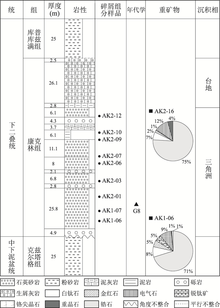
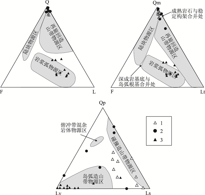
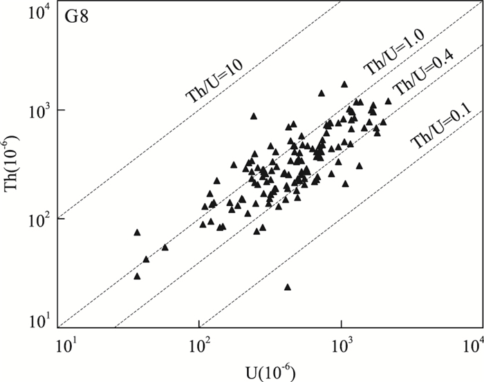
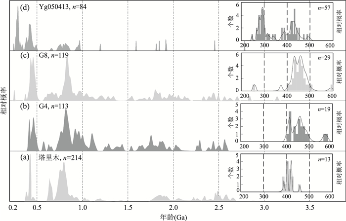
Carboniferous-Permian is the critical tectonic evolution period of the South Tianshan Ocean and the northern margin of Tarim basin. The Carboniferous-Permian outcrop, located in the northwestern margin of Tarim basin, near the South Tianshan orogen, is well exposed in the Sishichang area, and is selected to analyze this problem. Based on depositional system, sandstone skeleton component, heavy minerals, especially detrial zircon geochronology analysis by LA-ICP-MS in situ U-Pb and Lu-Hf isotope, this study further explores provenance, tectonic evolution and its geodynamic mechanism about the Tarim basin and the periphery orogenic belt. The results show that sandstone grains are dotted in the continental block provenances and the merger of fields for mature rocks with stable frameworks; the main proportions of heavy mineral assemblages are the stable heavy minerals. These results reflect that tectonic setting may be stable. The geochronological samples show multiphase tectono-thermal events with age groups of 407-501 Ma, 755-873 Ma, 889-1 129 Ma, 1 792-2 079 Ma, and 2 393-2 496 Ma. Compared with the potential source areas, the main provenance may be the Tarim palaeohigh. The redeposition of pre-Permian strata in the Tarim basin, associated with the erosion source in the Kunlun-Altun orogen, may also have some contribution. In other words, although the South Tianshan Ocean may have been closed, the South Tianshan orogenic belt did not uplift on a large scale until the Asselian. And the tectonic pattern and provenance of northwestern margin of Tarim basin changed little because of the closure. Referring to the previous data, it is concluded that the single source of the Tarim palaeohigh has developed into the dual sources of the Tarim basin and orogenic belt form Asselian to Sakmarian, and the provenance system of Keping area changes greatly. Furthermore, the South Tianshan Ocean, closed in Carboniferous, began to uplift in Sakmarian, and became an important source to the northwestern margin of Tarim basin.
Carboniferous-Permian is the critical tectonic evolution period of the South Tianshan Ocean and the northern margin of Tarim basin. The Carboniferous-Permian outcrop, located in the northwestern margin of Tarim basin, near the South Tianshan orogen, is well exposed in the Sishichang area, and is selected to analyze this problem. Based on depositional system, sandstone skeleton component, heavy minerals, especially detrial zircon geochronology analysis by LA-ICP-MS in situ U-Pb and Lu-Hf isotope, this study further explores provenance, tectonic evolution and its geodynamic mechanism about the Tarim basin and the periphery orogenic belt. The results show that sandstone grains are dotted in the continental block provenances and the merger of fields for mature rocks with stable frameworks; the main proportions of heavy mineral assemblages are the stable heavy minerals. These results reflect that tectonic setting may be stable. The geochronological samples show multiphase tectono-thermal events with age groups of 407-501 Ma, 755-873 Ma, 889-1 129 Ma, 1 792-2 079 Ma, and 2 393-2 496 Ma. Compared with the potential source areas, the main provenance may be the Tarim palaeohigh. The redeposition of pre-Permian strata in the Tarim basin, associated with the erosion source in the Kunlun-Altun orogen, may also have some contribution. In other words, although the South Tianshan Ocean may have been closed, the South Tianshan orogenic belt did not uplift on a large scale until the Asselian. And the tectonic pattern and provenance of northwestern margin of Tarim basin changed little because of the closure. Referring to the previous data, it is concluded that the single source of the Tarim palaeohigh has developed into the dual sources of the Tarim basin and orogenic belt form Asselian to Sakmarian, and the provenance system of Keping area changes greatly. Furthermore, the South Tianshan Ocean, closed in Carboniferous, began to uplift in Sakmarian, and became an important source to the northwestern margin of Tarim basin.


2018, 43(11): 4169-4179.
doi: 10.3799/dqkx.2017.594
Abstract:
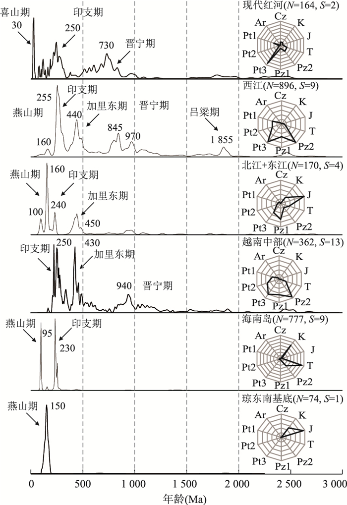
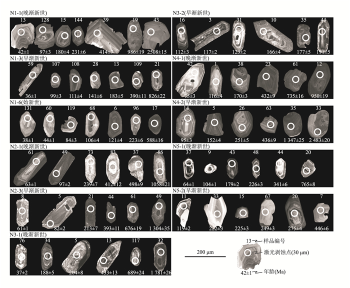
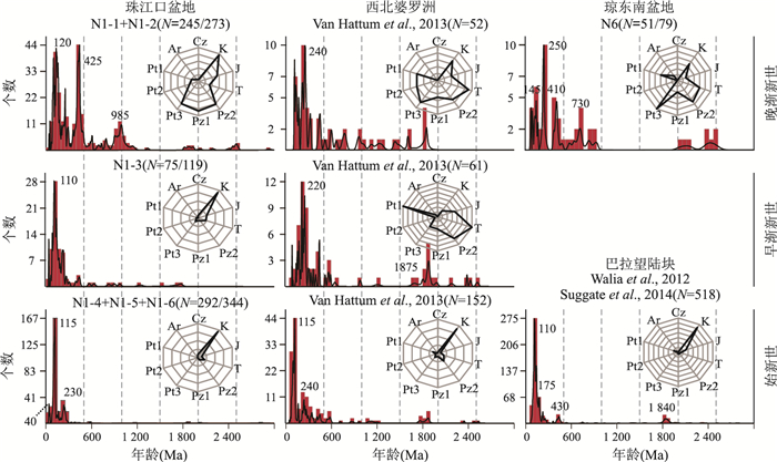
The early rift provenance evolution of the South China Sea (SCS) remains unsystematically explored due to limitations of borehole coverage and shortages of reliable dating results. In this study, detrital zircon U-Pb dating methodology was used to investigate the "source to sink" patterns of Paleogene syn-rift sequences in the northern SCS. In addition to the terrigenous supply transported from the north, it is found that intrabasinal provenances are also of great significance. The Eocene samples are dominated by Early Cretaceous zircon. The Early Oligocene sediments of Qiongdongnan basin indicate a source from Hainan Island and Xisha uplift while contemporary sediments of Zhu-1 depression in northern Pearl River Mouth basin were supplied by southeastern South China with highly-grained zircons sharing similar U-Pb age characteristics. Nevertheless, based on the existence of euhedral zircon shapes, Baiyun sag in southern Pearl River Mouth basin was most likely dominated by intrabasinal sources. The late Oligocene sequence of Liwan sag and Qiongdongnan basin could have been supplied by western uplift of the SCS with the increasing abundance of Proterozoic zircon ages. It has been revealed that the Pearl River could only have contributed to the infill of Zhu-1 depression during Early Oligocene before evolving into the terrigeous source for northern Zhu-2 depression in Late Oligocene. Conclusively, the Paleogene provenance development of the northern SCS is remarkably featured as episodic and diachronic Pearl River evolution processes.
The early rift provenance evolution of the South China Sea (SCS) remains unsystematically explored due to limitations of borehole coverage and shortages of reliable dating results. In this study, detrital zircon U-Pb dating methodology was used to investigate the "source to sink" patterns of Paleogene syn-rift sequences in the northern SCS. In addition to the terrigenous supply transported from the north, it is found that intrabasinal provenances are also of great significance. The Eocene samples are dominated by Early Cretaceous zircon. The Early Oligocene sediments of Qiongdongnan basin indicate a source from Hainan Island and Xisha uplift while contemporary sediments of Zhu-1 depression in northern Pearl River Mouth basin were supplied by southeastern South China with highly-grained zircons sharing similar U-Pb age characteristics. Nevertheless, based on the existence of euhedral zircon shapes, Baiyun sag in southern Pearl River Mouth basin was most likely dominated by intrabasinal sources. The late Oligocene sequence of Liwan sag and Qiongdongnan basin could have been supplied by western uplift of the SCS with the increasing abundance of Proterozoic zircon ages. It has been revealed that the Pearl River could only have contributed to the infill of Zhu-1 depression during Early Oligocene before evolving into the terrigeous source for northern Zhu-2 depression in Late Oligocene. Conclusively, the Paleogene provenance development of the northern SCS is remarkably featured as episodic and diachronic Pearl River evolution processes.


2018, 43(11): 4180-4192.
doi: 10.3799/dqkx.2018.211
Abstract:
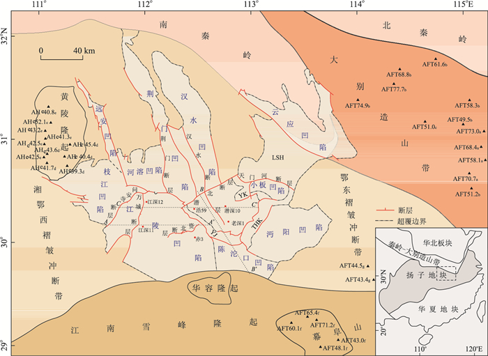
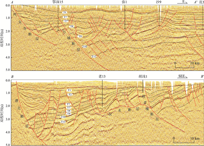
An extensional composite basin-mountain system is formed by Jianghan basin and its peripheral mountains, and there might be coupling relationship between the basin and orogenic belt. In this study, the subsidence history analysis shows the feature of episodic subsidence in Jianghan basin, which is divided into three rifting stages:Episodic Ⅰ Late Cretaceous, Episodic Ⅱ Paleocene Shashi-Early Eocene Xingouzui phase and Episodic Ⅲ Early Eocene Jingsha-Oligocene Jinghezhen phase. The subsidence center migrated regularly, and it moved to Jiangling depression in the Episodic Ⅱ and Qianjiang depression in the Episodic Ⅲ. The regular migration of subsidence center in the extensional composite basin-mountain system might be affected by many factors. In the meantime, it displays the response relationship between the migration of subsidence center and the peripheral mountains. The east mountains (Dabie orogen, Mufushan massif and Edong fold-thrust belt) uplift as the subsidence center migrates westward. And west mountains (Huangling massif and Xiang'exi fold-thrust belt) uplift as the subsidence center migrates eastward. In addition, the subsidence center shows the character of "deviation type" which migrates farther away from where the orogen uplifts. Meanwhile, the migration of subsidence center may also be affected by the changes of mantle diapir.
An extensional composite basin-mountain system is formed by Jianghan basin and its peripheral mountains, and there might be coupling relationship between the basin and orogenic belt. In this study, the subsidence history analysis shows the feature of episodic subsidence in Jianghan basin, which is divided into three rifting stages:Episodic Ⅰ Late Cretaceous, Episodic Ⅱ Paleocene Shashi-Early Eocene Xingouzui phase and Episodic Ⅲ Early Eocene Jingsha-Oligocene Jinghezhen phase. The subsidence center migrated regularly, and it moved to Jiangling depression in the Episodic Ⅱ and Qianjiang depression in the Episodic Ⅲ. The regular migration of subsidence center in the extensional composite basin-mountain system might be affected by many factors. In the meantime, it displays the response relationship between the migration of subsidence center and the peripheral mountains. The east mountains (Dabie orogen, Mufushan massif and Edong fold-thrust belt) uplift as the subsidence center migrates westward. And west mountains (Huangling massif and Xiang'exi fold-thrust belt) uplift as the subsidence center migrates eastward. In addition, the subsidence center shows the character of "deviation type" which migrates farther away from where the orogen uplifts. Meanwhile, the migration of subsidence center may also be affected by the changes of mantle diapir.


2018, 43(11): 4193-4203.
doi: 10.3799/dqkx.2018.242
Abstract:
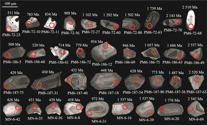
The unconformity of the Cambrian in the eastern margin of the Yunkai massif near Guigang, West Guangdong covers a set of gray-white quartz conglomerate-gravel sandstones. Due to the lack of fossils and U-Pb dating, the age of the stratum has remained controversial for a long time. By LA-ICP-MS U-Pb dating, a total of 300 valid data were obtained from 4 samples with age ranging from 2 900-400 Ma in this study. The samples below the unconformity surface are mainly concentrated at 1 100-700 Ma, and the youngest detrital zircon ages above the unconformity surface are concentrated at 450-400 Ma. The new dating data combined with previous research show that the ages of underlying and overlying strata in Guigang are Cambrian and Devonian, respectively. The source characteristics of the Cambrian are similar to those of the orogenic zone among India, eastern Antarctica and Australia. While the Devonian sources are relatively homogeneous, derived from the adjoining Yunkai massif. It is proposed that the unconformity of the study area should have resulted from the superposition of the Yu'nan orogeny and the Guangxi orogeny.
The unconformity of the Cambrian in the eastern margin of the Yunkai massif near Guigang, West Guangdong covers a set of gray-white quartz conglomerate-gravel sandstones. Due to the lack of fossils and U-Pb dating, the age of the stratum has remained controversial for a long time. By LA-ICP-MS U-Pb dating, a total of 300 valid data were obtained from 4 samples with age ranging from 2 900-400 Ma in this study. The samples below the unconformity surface are mainly concentrated at 1 100-700 Ma, and the youngest detrital zircon ages above the unconformity surface are concentrated at 450-400 Ma. The new dating data combined with previous research show that the ages of underlying and overlying strata in Guigang are Cambrian and Devonian, respectively. The source characteristics of the Cambrian are similar to those of the orogenic zone among India, eastern Antarctica and Australia. While the Devonian sources are relatively homogeneous, derived from the adjoining Yunkai massif. It is proposed that the unconformity of the study area should have resulted from the superposition of the Yu'nan orogeny and the Guangxi orogeny.


2018, 43(11): 4204-4214.
doi: 10.3799/dqkx.2017.578
Abstract:
Among the uncertainties in development of extra-low and ultra-low permeability reservoirs in the Qingshankou Formation, it is clear that the main controlling factors of the porosity, permeability, oil saturation and mobility are important issues to be solved. The characteristic parameters of extra-low and ultra-low permeability reservoirs in the Qingshankou Formation of the southern Songliao basin were quantitatively characterized by mercury intrusion, nuclear magnetic resonance, pore-permeability measurement, grain size analysis and X-ray diffraction test in this study. The results show that the pore throat size of the ultra-low permeability reservoir in southern Songliao basin is mainly distributed between 0.3 μm and 1.7 μm, which is the main controlling factor of reservoir property and fluidity. The pore throat radius of more than 1.5 μm corresponds to the conventional low permeability reservoir, and the rock type of the reservoir is mainly composed of fine feldspar lithic sandstone. 0.5-1.5 μm pore throat corresponds to ultra-low permeability reservoir. The rock type is mainly composed of very fine feldspathic lithic sandstone and coarse siltstone. The moveable fluid saturation is more than 65%; 0.1-0.5 μm pore throat corresponds to ultra-low permeability reservoir, and the rock type is mainly coarse-fine siltstone, moveable fluid saturation between 50%-60%. It is concluded that pore throat radius which has been controlled by the sedimentary facies determines the characteristics of reservoir physical properties and fluid saturation, and it should be used as a significant parameter of reservoir evaluation.
Among the uncertainties in development of extra-low and ultra-low permeability reservoirs in the Qingshankou Formation, it is clear that the main controlling factors of the porosity, permeability, oil saturation and mobility are important issues to be solved. The characteristic parameters of extra-low and ultra-low permeability reservoirs in the Qingshankou Formation of the southern Songliao basin were quantitatively characterized by mercury intrusion, nuclear magnetic resonance, pore-permeability measurement, grain size analysis and X-ray diffraction test in this study. The results show that the pore throat size of the ultra-low permeability reservoir in southern Songliao basin is mainly distributed between 0.3 μm and 1.7 μm, which is the main controlling factor of reservoir property and fluidity. The pore throat radius of more than 1.5 μm corresponds to the conventional low permeability reservoir, and the rock type of the reservoir is mainly composed of fine feldspar lithic sandstone. 0.5-1.5 μm pore throat corresponds to ultra-low permeability reservoir. The rock type is mainly composed of very fine feldspathic lithic sandstone and coarse siltstone. The moveable fluid saturation is more than 65%; 0.1-0.5 μm pore throat corresponds to ultra-low permeability reservoir, and the rock type is mainly coarse-fine siltstone, moveable fluid saturation between 50%-60%. It is concluded that pore throat radius which has been controlled by the sedimentary facies determines the characteristics of reservoir physical properties and fluid saturation, and it should be used as a significant parameter of reservoir evaluation.

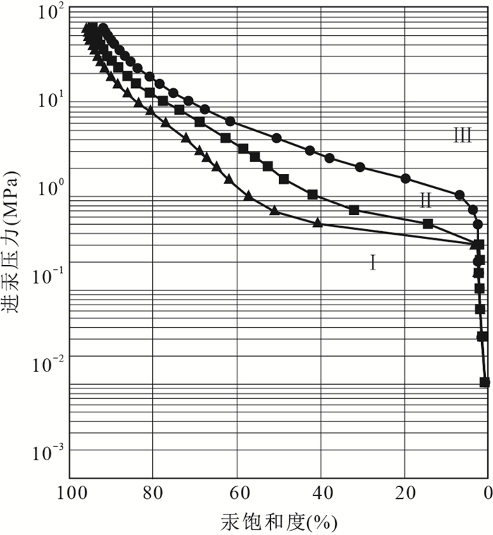
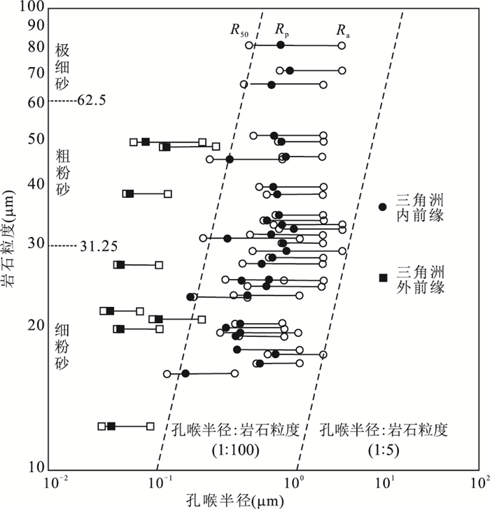


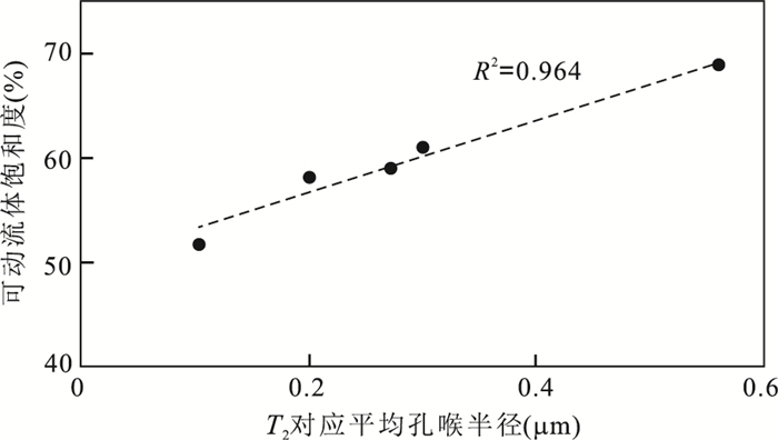


2018, 43(11): 4215-4225.
doi: 10.3799/dqkx.2018.253
Abstract:
As the one of the three major paleo-uplifts, the evolution of Hetian paleo-uplift and its control on hydrocarbon accumulation are limited, especially with the development of exploration. Based on the analysis of structure, zircon and hydrocarbon inclusion, it is found in this study that Hetian paleo-high has undergone many phases of poly-cycle tectonic evolution and superimposition and reformation, and has controlled Cambrian source rock's generation and expulsion of hydrocarbon, Ordovician's reservoir, and the process of oil and gas accumulation. In the period from middle Caledonian to early Hercynian, Hetian uplift controlled development of Ordovician carbonatite reservoir. YB1 well acquire which in Ordovician Yingshan Formation's crust of weathering, petroleum inclusion maturity, indicates two oil and gas fillings in Yingshan Formation's crust of weathering of carbonatite. In the period from late Caledonian to early Hercynian, there was the first phase of reservoir forming which has been destroyed and changed to pitch. Hydrocarbon inclusion and its associated gas-liquid two phase brine inclusions show temperature 100-110℃. Combined with the burial history, inclusion capture time is late Hercynian. In late Hercynian period, Hetian uplift burial, Cambrian source rock reached the peak period of hydrocarbon generation, Ordovician's entrapment got into shape, oil and gas migration filled along unconformity and fault, and high position and karst slope zones facilitated oil and gas accumulation, which made up the main accumulation stage. In Himalayan period, Hetian palaeohigh reversed, Ordovician paleo-reservoir adjusted and remoulded, oil and gas migrated northward. The structural pivot positions, in Markit slope of the Ordovician, are oil and gas accumulation zones. Midwest of the Yubei is advantageous target area for oil and gas.
As the one of the three major paleo-uplifts, the evolution of Hetian paleo-uplift and its control on hydrocarbon accumulation are limited, especially with the development of exploration. Based on the analysis of structure, zircon and hydrocarbon inclusion, it is found in this study that Hetian paleo-high has undergone many phases of poly-cycle tectonic evolution and superimposition and reformation, and has controlled Cambrian source rock's generation and expulsion of hydrocarbon, Ordovician's reservoir, and the process of oil and gas accumulation. In the period from middle Caledonian to early Hercynian, Hetian uplift controlled development of Ordovician carbonatite reservoir. YB1 well acquire which in Ordovician Yingshan Formation's crust of weathering, petroleum inclusion maturity, indicates two oil and gas fillings in Yingshan Formation's crust of weathering of carbonatite. In the period from late Caledonian to early Hercynian, there was the first phase of reservoir forming which has been destroyed and changed to pitch. Hydrocarbon inclusion and its associated gas-liquid two phase brine inclusions show temperature 100-110℃. Combined with the burial history, inclusion capture time is late Hercynian. In late Hercynian period, Hetian uplift burial, Cambrian source rock reached the peak period of hydrocarbon generation, Ordovician's entrapment got into shape, oil and gas migration filled along unconformity and fault, and high position and karst slope zones facilitated oil and gas accumulation, which made up the main accumulation stage. In Himalayan period, Hetian palaeohigh reversed, Ordovician paleo-reservoir adjusted and remoulded, oil and gas migrated northward. The structural pivot positions, in Markit slope of the Ordovician, are oil and gas accumulation zones. Midwest of the Yubei is advantageous target area for oil and gas.
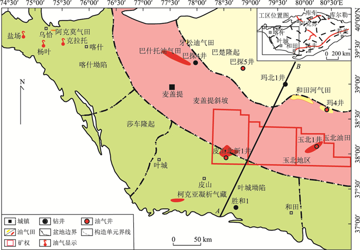


2018, 43(11): 4226-4236.
doi: 10.3799/dqkx.2018.552
Abstract:
The objective of this study is to identify the dominant rainfall-runoff generation mechanisms in the middle-low latitude alpine catchment, which can guide the exploitation and utilization of water resources, stream discharge and isotopic composition of rainwater and stream water in the Hongnigou catchment, an alpine catchment in the headwater regions of the Heihe River, Northeast Qinghai-Tibet plateau, were determined during two typical rainfall-runoff events on July 23 and August 21, 2013. Two-component hydrograph separation along with δ2H of rainwater and stream water was used to estimate the contributions of event and pre-event waters to streamflow and their variations over time. The results show that storm runoff was dominated by pre-event water, which contributed 68.69% and 54.46% of the total runoff during the two events, respectively. Pre-event water contributions decreased on rising limbs and increased on recession limbs. The results of the electrical conductivity of stream water suggest that runoff generation at the Hongnigou catchment was controlled by three hydrological processes, namely overland flow from the saturated zone, riparian groundwater, and hillslope groundwater. The majority of event water came from overland flow, whereas pre-event water mainly came from riparian and hillslope groundwaters. At the beginning and ending of the events, riparian groundwater dominated the runoff response while the contributions of overland flow and hillslope groundwater were limited. During the other parts of the events, i.e., from the late rising limb to early recession limb, overland flow and hillslope groundwater conversely dominated the runoff response, with the contribution of overland flow reaching its maximum at the streamflow peak. The comparison of event results indicates that event water contributions to streamflow were related to antecedent wetness conditions and rainfall intensity. Event water contribution was larger during the event with higher antecedent moisture condition or with higher rainfall intensity.
The objective of this study is to identify the dominant rainfall-runoff generation mechanisms in the middle-low latitude alpine catchment, which can guide the exploitation and utilization of water resources, stream discharge and isotopic composition of rainwater and stream water in the Hongnigou catchment, an alpine catchment in the headwater regions of the Heihe River, Northeast Qinghai-Tibet plateau, were determined during two typical rainfall-runoff events on July 23 and August 21, 2013. Two-component hydrograph separation along with δ2H of rainwater and stream water was used to estimate the contributions of event and pre-event waters to streamflow and their variations over time. The results show that storm runoff was dominated by pre-event water, which contributed 68.69% and 54.46% of the total runoff during the two events, respectively. Pre-event water contributions decreased on rising limbs and increased on recession limbs. The results of the electrical conductivity of stream water suggest that runoff generation at the Hongnigou catchment was controlled by three hydrological processes, namely overland flow from the saturated zone, riparian groundwater, and hillslope groundwater. The majority of event water came from overland flow, whereas pre-event water mainly came from riparian and hillslope groundwaters. At the beginning and ending of the events, riparian groundwater dominated the runoff response while the contributions of overland flow and hillslope groundwater were limited. During the other parts of the events, i.e., from the late rising limb to early recession limb, overland flow and hillslope groundwater conversely dominated the runoff response, with the contribution of overland flow reaching its maximum at the streamflow peak. The comparison of event results indicates that event water contributions to streamflow were related to antecedent wetness conditions and rainfall intensity. Event water contribution was larger during the event with higher antecedent moisture condition or with higher rainfall intensity.
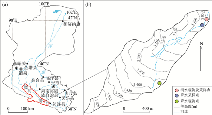


2018, 43(11): 4237-4245.
doi: 10.3799/dqkx.2018.140
Abstract:
Karst underground river is an important water source in Southwest China. In addition to entering and polluting the groundwater directly through the sinkholes, arsenic pollutants produced from the industrial production process will also adsorb, remain, and concentrate in the dissolution cracks and gaps in the surface karst zone, and remigrate under certain conditions to become a "secondary pollution source". Taking an arsenic pollution event in Guangxi as an example, the dynamic adsorption and desorption experiments of arsenic were carried out by using narrow slot physical model device, and the migration rule of arsenic contamination in the soil of surface karst zone was studied, combined with geochemical simulation. The experimental results show that the adsorption of arsenic in the surface karst zone is mainly physical adsorption (diffusion process), and the desorption rate is slow compared with the adsorption process, while the acid solution can promote the desorption process of arsenic compared with deionized water. The results of geochemical simulation show that goethite contributes most to arsenic adsorption in soil minerals, while acid solution weakens the ability of arsenic adsorption by corroding goethite and other minerals. It is concluded that in the karst area of Southwest China, once the surface karst zone system is integrated with arsenic pollutants, the desorption process is slow, and it is easy to form the retention and enrichment of arsenic pollutants; while the accelerated desorption and migration process of arsenic under acid rain will increase the pollution risk of groundwater system.
Karst underground river is an important water source in Southwest China. In addition to entering and polluting the groundwater directly through the sinkholes, arsenic pollutants produced from the industrial production process will also adsorb, remain, and concentrate in the dissolution cracks and gaps in the surface karst zone, and remigrate under certain conditions to become a "secondary pollution source". Taking an arsenic pollution event in Guangxi as an example, the dynamic adsorption and desorption experiments of arsenic were carried out by using narrow slot physical model device, and the migration rule of arsenic contamination in the soil of surface karst zone was studied, combined with geochemical simulation. The experimental results show that the adsorption of arsenic in the surface karst zone is mainly physical adsorption (diffusion process), and the desorption rate is slow compared with the adsorption process, while the acid solution can promote the desorption process of arsenic compared with deionized water. The results of geochemical simulation show that goethite contributes most to arsenic adsorption in soil minerals, while acid solution weakens the ability of arsenic adsorption by corroding goethite and other minerals. It is concluded that in the karst area of Southwest China, once the surface karst zone system is integrated with arsenic pollutants, the desorption process is slow, and it is easy to form the retention and enrichment of arsenic pollutants; while the accelerated desorption and migration process of arsenic under acid rain will increase the pollution risk of groundwater system.


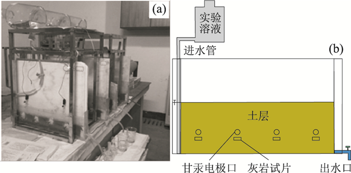


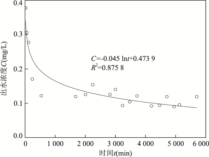
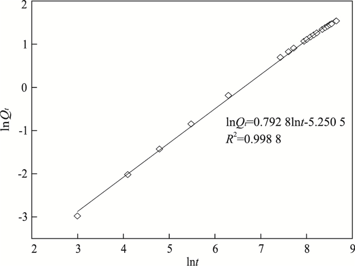
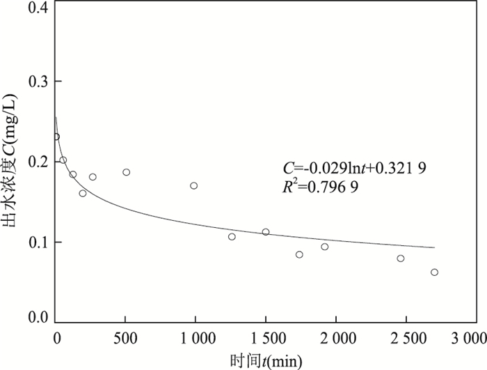
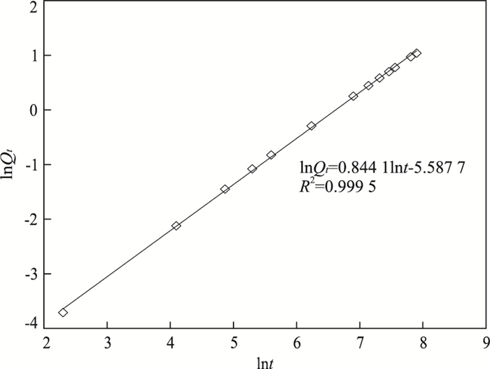
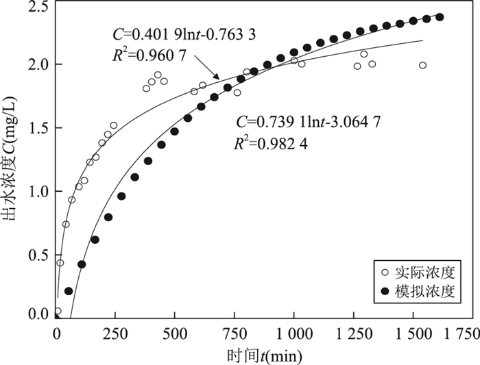
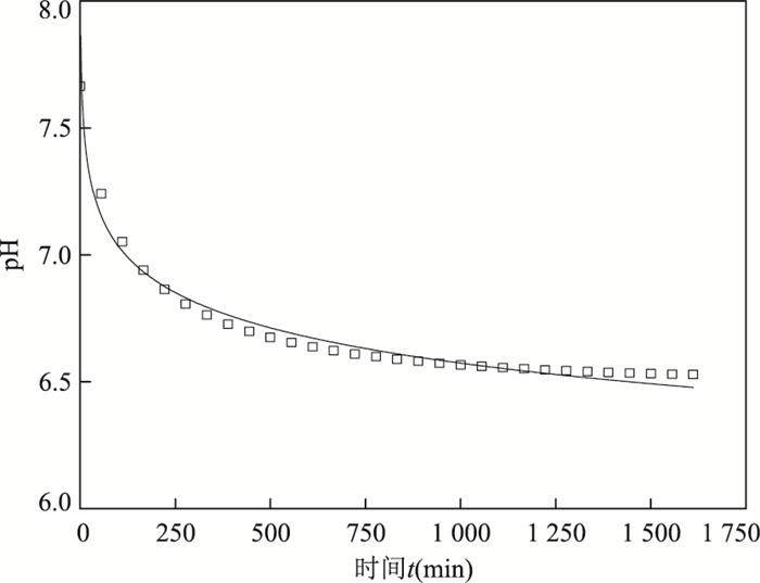
2018, 43(11): 4246-4255.
doi: 10.3799/dqkx.2018.203
Abstract:
The quantitative research on the interaction between surface water and groundwater in alpine and cold regions is of essential significance for the evaluation and management of the water resources. However, there are relatively few quantitative researches carried out on the interaction between surface water and groundwater in alpine and cold region. Taking Hulugou watershed in upper reach of the Heihe River with permafrost distributed as the study site, monitored temperature time series were used to identify the interactions between river and groundwater, and the utility of heat tracers is also evaluated in this paper. Temperatures of groundwater riverbed sediments at different depths, river stage and groundwater level were monitored at the site. Then, the vertical flow velocities of river water infiltration to groundwater at 3 points along river channel were calculated through the Hatch analytical solutions with the monitored data. The results indicate that river stage was higher than groundwater level, suggesting the recharge of the river water to the groundwater. Temperatures of riverbed sediments were higher in July in comparison with those in September. The river infiltration velocity was between 2×10⁻⁶-5×10⁻⁵ m/s in the monitoring period. The analyses show that exchange between river and groundwater can be estimated by heat tracers in alpine and cold regions. However, the other recharge sources to groundwater should be investigated by other methods such as isotopic method and numerical modeling. Exchange between river and groundwater is mainly controlled by the relationship between river stage and groundwater level, hydraulic conductivity and heat capacity of riverbed sediments.
The quantitative research on the interaction between surface water and groundwater in alpine and cold regions is of essential significance for the evaluation and management of the water resources. However, there are relatively few quantitative researches carried out on the interaction between surface water and groundwater in alpine and cold region. Taking Hulugou watershed in upper reach of the Heihe River with permafrost distributed as the study site, monitored temperature time series were used to identify the interactions between river and groundwater, and the utility of heat tracers is also evaluated in this paper. Temperatures of groundwater riverbed sediments at different depths, river stage and groundwater level were monitored at the site. Then, the vertical flow velocities of river water infiltration to groundwater at 3 points along river channel were calculated through the Hatch analytical solutions with the monitored data. The results indicate that river stage was higher than groundwater level, suggesting the recharge of the river water to the groundwater. Temperatures of riverbed sediments were higher in July in comparison with those in September. The river infiltration velocity was between 2×10⁻⁶-5×10⁻⁵ m/s in the monitoring period. The analyses show that exchange between river and groundwater can be estimated by heat tracers in alpine and cold regions. However, the other recharge sources to groundwater should be investigated by other methods such as isotopic method and numerical modeling. Exchange between river and groundwater is mainly controlled by the relationship between river stage and groundwater level, hydraulic conductivity and heat capacity of riverbed sediments.
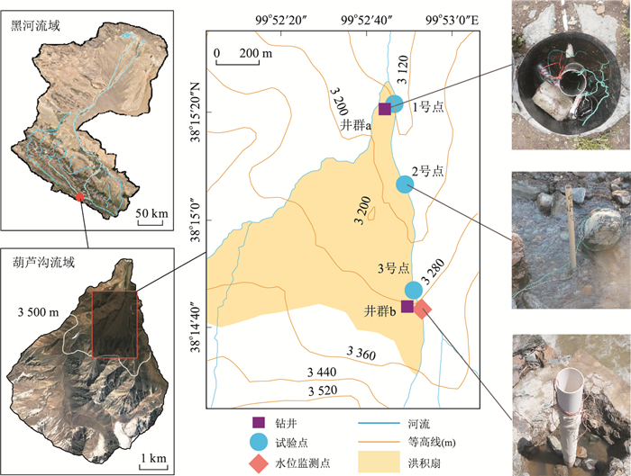


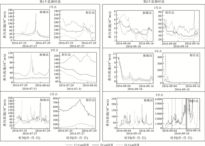
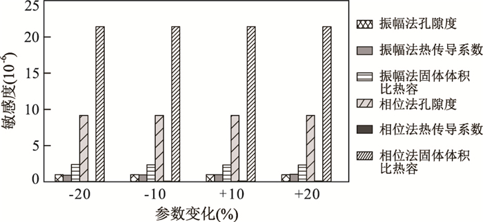
2018, 43(11): 4256-4266.
doi: 10.3799/dqkx.2018.210
Abstract:
Geothermal energy is attracting increasing attention. However, the formation mechanism and the source of heat in geothermal fields are still in dispute. Most scholars believe that the magma pocket can provide direct heating for geothermal fields. In this paper, by means of 2D forward modeling of heat conduction, it is found that the caprock is a necessary condition for forming geothermal fields. When there is a high heat conduction layer in the shallow part, the geothermal profile will display a mirror reflection shape, and the temperature will be divided into high gradient section, low gradient section and low temperature section. The heat dissipation and thermal equilibrium time of the shallow magma pocket (< 10 km) are less than 200 000-500 000 years. Based on the analysis of the temperature data of a large number of geothermal fields, it is concluded that the heat in geothermal fields is from normal basal heat flow instead of the presence of abnormal heat sources, such as magma pocke. When the deep heat is transferred to surface, the temperature field changes due to the difference in the heat conduction ability of the near-surface material:the high heat conduction layer under the geothermal field will rapidly transfer the base heat to the shallow layer and form the abnormal high temperature.
Geothermal energy is attracting increasing attention. However, the formation mechanism and the source of heat in geothermal fields are still in dispute. Most scholars believe that the magma pocket can provide direct heating for geothermal fields. In this paper, by means of 2D forward modeling of heat conduction, it is found that the caprock is a necessary condition for forming geothermal fields. When there is a high heat conduction layer in the shallow part, the geothermal profile will display a mirror reflection shape, and the temperature will be divided into high gradient section, low gradient section and low temperature section. The heat dissipation and thermal equilibrium time of the shallow magma pocket (< 10 km) are less than 200 000-500 000 years. Based on the analysis of the temperature data of a large number of geothermal fields, it is concluded that the heat in geothermal fields is from normal basal heat flow instead of the presence of abnormal heat sources, such as magma pocke. When the deep heat is transferred to surface, the temperature field changes due to the difference in the heat conduction ability of the near-surface material:the high heat conduction layer under the geothermal field will rapidly transfer the base heat to the shallow layer and form the abnormal high temperature.
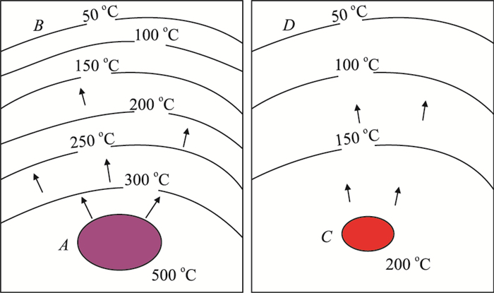


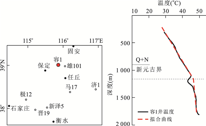
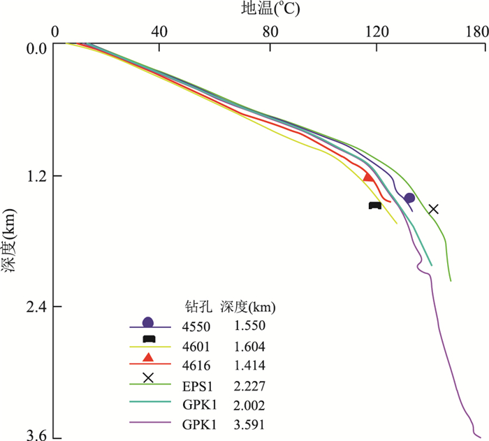
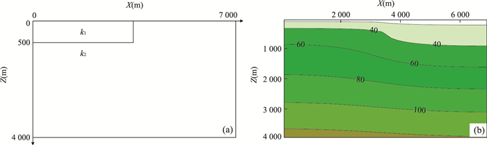


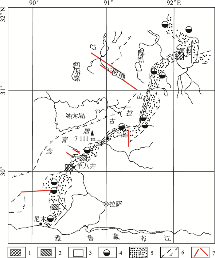
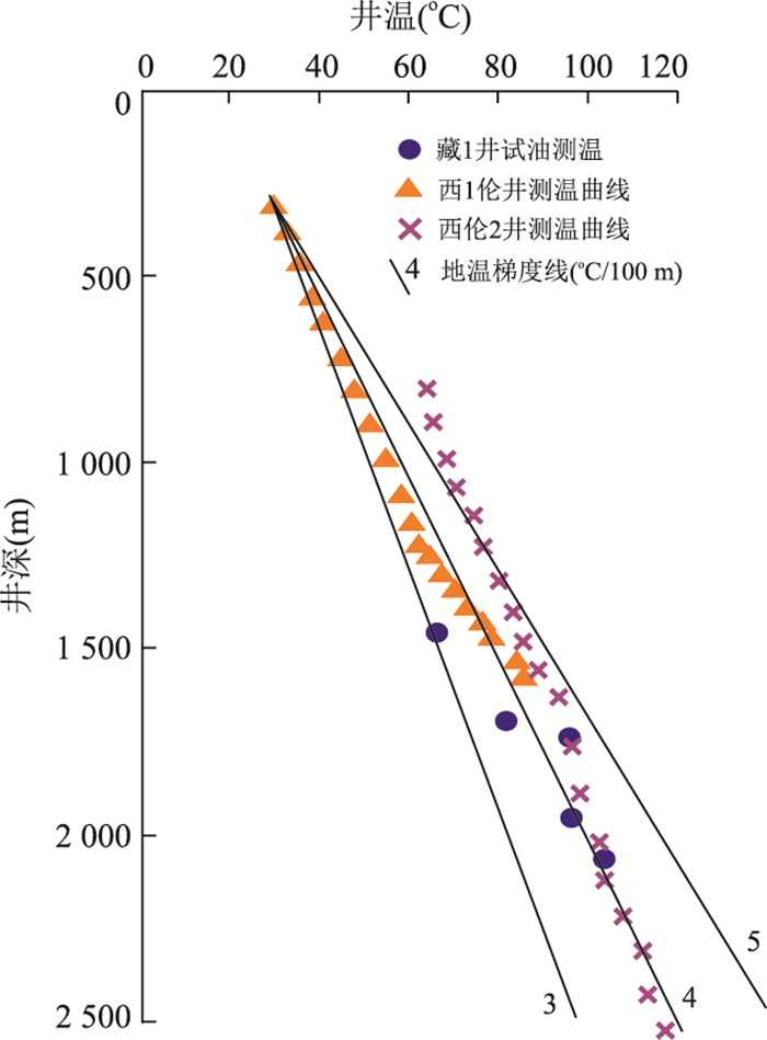

2018, 43(11): 4008-4017.
doi: 10.3799/dqkx.2018.726
Abstract:
In order to study the impact of global warming on the ecological environments of high latitude ocean, the lipid biomarkers of a sediment core called BL16 were studied, which was collected during the Fifth Chinese National Arctic Expedition Cruise at the Bering Sea shelf. These compounds, including saturated hydrocarbons and fatty acids; show that the organic matter in the sediments is the mixed input of terrigenous and marine sources. The long chain n-alkanes and long chain saturated fatty acids are mainly derived from terrestrial higher plants, while saturated iso- and anteiso-fatty acids mainly originate from marine autotrophic bacteria. Two of the concentrations of short chain n-alkanes, anteiso-alkanes and alkylcyclopentanes are well interrelated, suggesting that these compounds share the same source and are mainly from phytoplankton and microbes. The relative ratios of the short to long chain n-alkanes (∑C15-21/∑C23-33) vary from 0.14 to 0.90 in sediments, indicating that the n-alkanes are primarily derived from terrestrial sources. The concentrations of short chain n-alkanes, anteiso-alkanes and alkylcyclopentanes, and the relative abundances of saturated iso-, anteiso-fatty acids to saturated long chain fatty acids are consistent with total organic carbon (TOC) and total nitrogen (TN) in the sediment core and show an apparent increase since the 1970s, which may reflect the continuously increasing trend of marine primary productivity and a sensitive response to global warming.
In order to study the impact of global warming on the ecological environments of high latitude ocean, the lipid biomarkers of a sediment core called BL16 were studied, which was collected during the Fifth Chinese National Arctic Expedition Cruise at the Bering Sea shelf. These compounds, including saturated hydrocarbons and fatty acids; show that the organic matter in the sediments is the mixed input of terrigenous and marine sources. The long chain n-alkanes and long chain saturated fatty acids are mainly derived from terrestrial higher plants, while saturated iso- and anteiso-fatty acids mainly originate from marine autotrophic bacteria. Two of the concentrations of short chain n-alkanes, anteiso-alkanes and alkylcyclopentanes are well interrelated, suggesting that these compounds share the same source and are mainly from phytoplankton and microbes. The relative ratios of the short to long chain n-alkanes (∑C15-21/∑C23-33) vary from 0.14 to 0.90 in sediments, indicating that the n-alkanes are primarily derived from terrestrial sources. The concentrations of short chain n-alkanes, anteiso-alkanes and alkylcyclopentanes, and the relative abundances of saturated iso-, anteiso-fatty acids to saturated long chain fatty acids are consistent with total organic carbon (TOC) and total nitrogen (TN) in the sediment core and show an apparent increase since the 1970s, which may reflect the continuously increasing trend of marine primary productivity and a sensitive response to global warming.


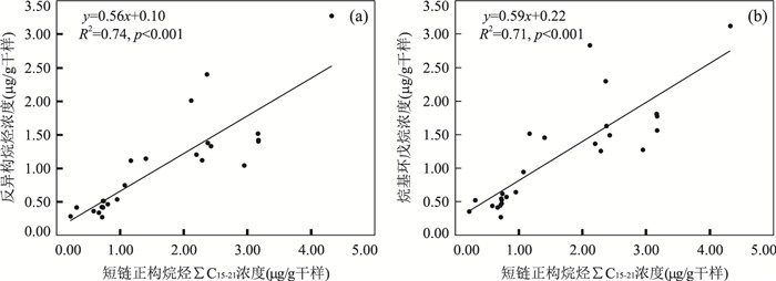
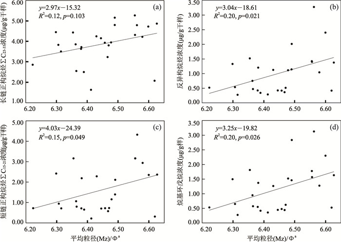
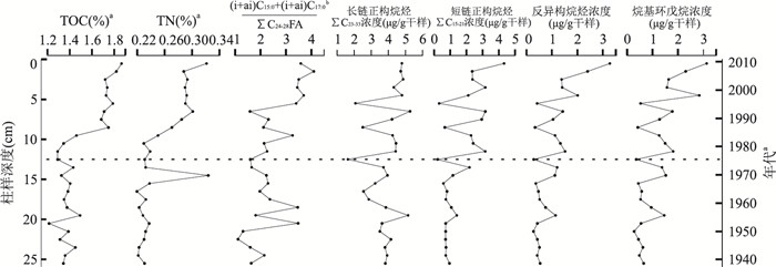
2018, 43(11): 4018-4026.
doi: 10.3799/dqkx.2017.610
Abstract:
"Wushan loess", regarded as the southern boundary of Chinese Loess, is distributed in the Three Gorges area in the Yangtze River, which contains rich paleoclimatic information attracting attentions of many scholars in paleoclimate. In order to further reveal its causes and better understand the paleoclimatic significance contained in Wushan loess, the glycerol dialkyl glycerol tetraethers (GDGTs) extracted from Wushan loess section were investigated. Comparing the mean annual air temperature (MAAT) reconstructed based on branched GDGTs (bGDGTs) with frequency-dependent magnetic susceptibility and North Atlantic sediments, it is found that the three curves are analogous in climate evolution patterns. These similarities show that climatic changes in Wushan region respond to global climatic changes. The BIT values range from 0.5-1.0 and most BIT (bGDGTs vs. crenarchaeol) values are close to 1. The low BIT values suggest that it was very dry at 36.2 ka.BP, 30.2 ka.BP and 23.5 ka.BP. Based on MAAT and BIT values, it is found that it was relatively cold when it was very dry. It is proposed that the three periods correspond to H4, H3, H2 climate events, respectively.
"Wushan loess", regarded as the southern boundary of Chinese Loess, is distributed in the Three Gorges area in the Yangtze River, which contains rich paleoclimatic information attracting attentions of many scholars in paleoclimate. In order to further reveal its causes and better understand the paleoclimatic significance contained in Wushan loess, the glycerol dialkyl glycerol tetraethers (GDGTs) extracted from Wushan loess section were investigated. Comparing the mean annual air temperature (MAAT) reconstructed based on branched GDGTs (bGDGTs) with frequency-dependent magnetic susceptibility and North Atlantic sediments, it is found that the three curves are analogous in climate evolution patterns. These similarities show that climatic changes in Wushan region respond to global climatic changes. The BIT values range from 0.5-1.0 and most BIT (bGDGTs vs. crenarchaeol) values are close to 1. The low BIT values suggest that it was very dry at 36.2 ka.BP, 30.2 ka.BP and 23.5 ka.BP. Based on MAAT and BIT values, it is found that it was relatively cold when it was very dry. It is proposed that the three periods correspond to H4, H3, H2 climate events, respectively.

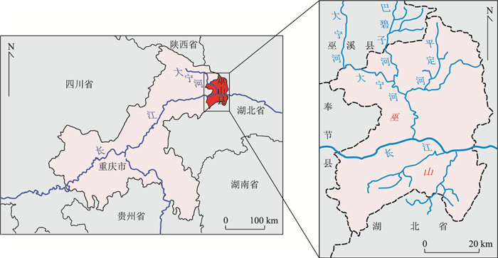
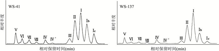

2018, 43(11): 4027-4035.
doi: 10.3799/dqkx.2018.284
Abstract:
To investigate the spatial distribution of lipid biomarkers from offshore to deep basin in the marginal sea, fatty acids (FAs) in surface sediments collected from different water depths across four different transects were studied. Abundant FAs, including saturated and unsaturated normal FAs, as well as saturated iso- and anteiso-FAs, were detected. The FAs are dominated by short-chain saturated FAs, showing a mono-model distribution. The long-chain FAs, showing an even-over-odd distribution, are mainly derived from terrestrial higher plants, and short-chain normal FAs are derived from marine phytoplankton, while saturated iso- and anteiso-FAs are mainly contributed by marine bacteria. The long-chain FAs derived from the higher plants show the higher concentration in the coastal area which is contributed by the fluvial input, as well as in the deep basin which may be resulted from the ocean current, and likely, the aeolian dust input. Branched short-chain FAs indicate that the bacteria have great contribution in the coastal area but not in the deep basin. Short-chain normal FAs indicate that the phytoplankton relative abundance is great in northeast South China Sea and the deep basin. The higher contribution of both bacteria and phytoplankton in the coastal area is possibly related to higher nutrient input, while the higher phytoplankton distribution in the deep basin may be influenced by the ocean current or other input.
To investigate the spatial distribution of lipid biomarkers from offshore to deep basin in the marginal sea, fatty acids (FAs) in surface sediments collected from different water depths across four different transects were studied. Abundant FAs, including saturated and unsaturated normal FAs, as well as saturated iso- and anteiso-FAs, were detected. The FAs are dominated by short-chain saturated FAs, showing a mono-model distribution. The long-chain FAs, showing an even-over-odd distribution, are mainly derived from terrestrial higher plants, and short-chain normal FAs are derived from marine phytoplankton, while saturated iso- and anteiso-FAs are mainly contributed by marine bacteria. The long-chain FAs derived from the higher plants show the higher concentration in the coastal area which is contributed by the fluvial input, as well as in the deep basin which may be resulted from the ocean current, and likely, the aeolian dust input. Branched short-chain FAs indicate that the bacteria have great contribution in the coastal area but not in the deep basin. Short-chain normal FAs indicate that the phytoplankton relative abundance is great in northeast South China Sea and the deep basin. The higher contribution of both bacteria and phytoplankton in the coastal area is possibly related to higher nutrient input, while the higher phytoplankton distribution in the deep basin may be influenced by the ocean current or other input.

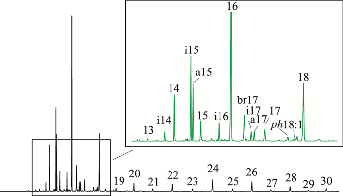


2018, 43(11): 4046-4055.
doi: 10.3799/dqkx.2018.152
Abstract:
The compositional break between ferroan dolomite and ankerite has not been well-defined for a long time. Ankerite has always been regarded as a secondary mineral generated at high temperatures. In this paper, progress in mineralogy and origins of ankerite and a link between microbial activity and ankerite are evaluated. Based on documented data:(1) The compositional break based on the "50% rule" principle from International Association of Mineralogy is applied for Ca-Mg-Fe carbonate. Any minerals with more than 50 mol% Fe in the Mg site would be called ankerite; (2) Progresses in mineralogical and lattice characteristics of ankerite are presented; (3) The origins of ankerite are primary and secondary. In the process of microbial mediated primary dolomite, microbe facilitates iron into the dolomite lattice and increases the iron content in the Mg site in its structure. Microbes could be added into the primary sedimentary experiments to promote mediation of the primary ankerite.
The compositional break between ferroan dolomite and ankerite has not been well-defined for a long time. Ankerite has always been regarded as a secondary mineral generated at high temperatures. In this paper, progress in mineralogy and origins of ankerite and a link between microbial activity and ankerite are evaluated. Based on documented data:(1) The compositional break based on the "50% rule" principle from International Association of Mineralogy is applied for Ca-Mg-Fe carbonate. Any minerals with more than 50 mol% Fe in the Mg site would be called ankerite; (2) Progresses in mineralogical and lattice characteristics of ankerite are presented; (3) The origins of ankerite are primary and secondary. In the process of microbial mediated primary dolomite, microbe facilitates iron into the dolomite lattice and increases the iron content in the Mg site in its structure. Microbes could be added into the primary sedimentary experiments to promote mediation of the primary ankerite.


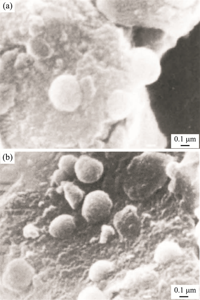
2018, 43(11): 4066-4095.
doi: 10.3799/dqkx.2017.590
Abstract:
The Cambrian Stage 4 represents a key point in the history of life in Longwangmiao Formation, carbonate is main rocks and diamictite widely distributed at its lower-middle part, with the slight occurrence of bioclast. The major and trace element analyses show that Longwangmiao Formation carbonate has various contents of ∑(CaO+MgO+LOI) from 74.64% to 99.18%, high Na2O, K2O, Fe2O3 and MnO concentrations (with an average of 0.20%, 0.27%, 0.27% and 0.014%, respectively), low Sr contents (135×10-6-407×10-6), gradually decreased contents of ∑(SiO2+Al2O3+Fe2O3+ P2O5+TiO2) upward section, extremely positive Ce anomalies (δCe=5.6-6.2) and a distinctive LREE-enriched pattern all the section (∑LREE/∑HREE=2-4), coupled with relatively high contents of ∑REE+Y at its middle part. The whole carbonates possess δ13C values from -1.5‰ to 1.1‰ VPDB and δ18O values from -9.7‰ to -3.5‰ VPDB, while calcites have relatively high δ13C values (-3.4‰ to +0.5‰ VPDB) and approximate δ18O values (-9.8‰ to -5.0‰ VPDB), alongside a gradual increase in carbon isotopic composition of both whole carbonates and calcites from its lower part to the upper section. Geochemical indictors of different palaeoenvironmental factors, involved palaeoclimate (MgO/CaO), seawater temperature and salinity (δ13C, δ18O, 100×MgO/Al2O3 and Bproof read), relative seawater depth (Sr/Ba, 1 000×Sr/Ca) and redox condition (U/Th, V/(V+Ni)), etc., imply that Longwangmiao Formation deposited at salt-brackish water under 17-25℃ during the transition mainly from the relative oxidizing and paralic environment to the dysaerobic-anaerobic and shallow marine environment, with an abundant riverine influx at its early period and frequent fluctuations of paleoclimate from relatively humid to arid, which would build the environmental stress and then lead to the major biomass reduction.
The Cambrian Stage 4 represents a key point in the history of life in Longwangmiao Formation, carbonate is main rocks and diamictite widely distributed at its lower-middle part, with the slight occurrence of bioclast. The major and trace element analyses show that Longwangmiao Formation carbonate has various contents of ∑(CaO+MgO+LOI) from 74.64% to 99.18%, high Na2O, K2O, Fe2O3 and MnO concentrations (with an average of 0.20%, 0.27%, 0.27% and 0.014%, respectively), low Sr contents (135×10-6-407×10-6), gradually decreased contents of ∑(SiO2+Al2O3+Fe2O3+ P2O5+TiO2) upward section, extremely positive Ce anomalies (δCe=5.6-6.2) and a distinctive LREE-enriched pattern all the section (∑LREE/∑HREE=2-4), coupled with relatively high contents of ∑REE+Y at its middle part. The whole carbonates possess δ13C values from -1.5‰ to 1.1‰ VPDB and δ18O values from -9.7‰ to -3.5‰ VPDB, while calcites have relatively high δ13C values (-3.4‰ to +0.5‰ VPDB) and approximate δ18O values (-9.8‰ to -5.0‰ VPDB), alongside a gradual increase in carbon isotopic composition of both whole carbonates and calcites from its lower part to the upper section. Geochemical indictors of different palaeoenvironmental factors, involved palaeoclimate (MgO/CaO), seawater temperature and salinity (δ13C, δ18O, 100×MgO/Al2O3 and Bproof read), relative seawater depth (Sr/Ba, 1 000×Sr/Ca) and redox condition (U/Th, V/(V+Ni)), etc., imply that Longwangmiao Formation deposited at salt-brackish water under 17-25℃ during the transition mainly from the relative oxidizing and paralic environment to the dysaerobic-anaerobic and shallow marine environment, with an abundant riverine influx at its early period and frequent fluctuations of paleoclimate from relatively humid to arid, which would build the environmental stress and then lead to the major biomass reduction.


Carbon Isotope Excursions of Cambrian Hwangju and Bopdong Groups in Pyongnam Basin, Korean Peninsula
2018, 43(11): 4096-4108.
doi: 10.3799/dqkx.2018.107
Abstract:
The Cambrian strata in the Pyongnam basin in Korea include the Hwangju Group and the lower Bopdong Group. To compare the Cambrian strata of this basin with those in the adjacent regions and areas beyond, this paper performs biostratigraphy research and isotope analysis of carbon and oxygen isotopes of typical carbonates of the Hwangju Group (the Pyongsan, Junghwa, Hukgyo and Rimchon Fms.) and the lower Bopdong Group (the Mujin and Kopung Fms.). Based on biostratigraphic research, the Pyongsan and Junghua Formations should be no lower than Stage 3 and Stage 4, respectively. δ13C values in the Pyongsan Fm. range from 0 to -3.1‰, Junghua -4.7‰ to 2.0‰, Hukgyo -1.0‰ to 2.4‰, Rimchon -2.6‰ to 0.4‰, Mujin -1.3‰ to 0.4‰, and Kopung -1.0‰ to 2.4‰. Synthetically, it is argued that the Pyongsan, Junghua and Hukgyo Fms. belong to Stages 3-4 of Cambrian, the Rimchon Fm. is around the boundary of Series 2 and Miaoling Series, and the Kopung Fm. belongs to the Furong Series of Cambrian. And the three carbon excursions in the upper Junghwa-Hukgyo Fm. (positive), the lower Rimchon Fm. (negative) and the middle Kopung Fm. (positive) are comparable to the global events of the mIngxinsi carbon isotope excursion, redlichiid-olenellid extinction carbon isotope excursion and steptoean positive carbon isotope excursion, respectively.
The Cambrian strata in the Pyongnam basin in Korea include the Hwangju Group and the lower Bopdong Group. To compare the Cambrian strata of this basin with those in the adjacent regions and areas beyond, this paper performs biostratigraphy research and isotope analysis of carbon and oxygen isotopes of typical carbonates of the Hwangju Group (the Pyongsan, Junghwa, Hukgyo and Rimchon Fms.) and the lower Bopdong Group (the Mujin and Kopung Fms.). Based on biostratigraphic research, the Pyongsan and Junghua Formations should be no lower than Stage 3 and Stage 4, respectively. δ13C values in the Pyongsan Fm. range from 0 to -3.1‰, Junghua -4.7‰ to 2.0‰, Hukgyo -1.0‰ to 2.4‰, Rimchon -2.6‰ to 0.4‰, Mujin -1.3‰ to 0.4‰, and Kopung -1.0‰ to 2.4‰. Synthetically, it is argued that the Pyongsan, Junghua and Hukgyo Fms. belong to Stages 3-4 of Cambrian, the Rimchon Fm. is around the boundary of Series 2 and Miaoling Series, and the Kopung Fm. belongs to the Furong Series of Cambrian. And the three carbon excursions in the upper Junghwa-Hukgyo Fm. (positive), the lower Rimchon Fm. (negative) and the middle Kopung Fm. (positive) are comparable to the global events of the mIngxinsi carbon isotope excursion, redlichiid-olenellid extinction carbon isotope excursion and steptoean positive carbon isotope excursion, respectively.