2018 Vol. 43, No. 2
Display Method:
 PDF 279KB
2018, 43(2): 333-353.
doi: 10.3799/dqkx.2017.582
Abstract:
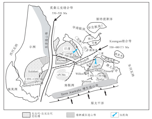
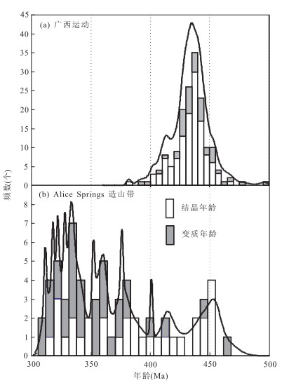
The Early Paleozoic Kwangsian Orogeny in South China is considered to have resulted from the intraplate deformation. However the geodynamic mechanism for the intraplate deformation remains unclear. The Early Paleozoic orogenesis is marked by a regional unconformity between pre-Devonian and Devonian strata and multiple stratigraphic unconformities developed within the Early Paleozoic sequence in the local areas of southeast South China.The Kwangsian magmatism, metamorphism and palaeontological variation are dated from 460 to 380 Ma.These events are in age linked to the multiple unconformities between the Ordovician and Devonian sequences. The unconformity between the Late Cambrian and Early Ordovician, named as the Yu'nan Event in the southern margin of South China, is lack of contemporaneous petrological records, except for minor metamorphic rocks dated at 530-480 Ma. The range of this unconformity corresponds with timing of orogenic activity extending along the northern margin of East Gondwana.Derivation of detrital zircons from the Cambrian and Ordovician strata in the southern part of South China suggests that in the Cambrian South China constituted part of the north India and the Sanya Block presented currently in Hainan Island had not been part of South China but rather part of western Australia until the juxtaposition of South China and west Australia in the Early Ordovician.The event removed the Cathaysia Block from any spatial association with an active plate boundary and permitted the stresses sourced from the accretionary orogen in East Gondwana to propagate inboard across the supercontinent. These stresses localized along the site of the weak rheological Nanhua basin and consequently resulted in basin inversion and development of the intraplate Kwangsian Orogeny. The Early Paleozoic orogenesis in the southeastern part of South China evolved from periphery collision in the Yu'nan Event to intraplate orogeny in the Kwangsian Orogeny.
The Early Paleozoic Kwangsian Orogeny in South China is considered to have resulted from the intraplate deformation. However the geodynamic mechanism for the intraplate deformation remains unclear. The Early Paleozoic orogenesis is marked by a regional unconformity between pre-Devonian and Devonian strata and multiple stratigraphic unconformities developed within the Early Paleozoic sequence in the local areas of southeast South China.The Kwangsian magmatism, metamorphism and palaeontological variation are dated from 460 to 380 Ma.These events are in age linked to the multiple unconformities between the Ordovician and Devonian sequences. The unconformity between the Late Cambrian and Early Ordovician, named as the Yu'nan Event in the southern margin of South China, is lack of contemporaneous petrological records, except for minor metamorphic rocks dated at 530-480 Ma. The range of this unconformity corresponds with timing of orogenic activity extending along the northern margin of East Gondwana.Derivation of detrital zircons from the Cambrian and Ordovician strata in the southern part of South China suggests that in the Cambrian South China constituted part of the north India and the Sanya Block presented currently in Hainan Island had not been part of South China but rather part of western Australia until the juxtaposition of South China and west Australia in the Early Ordovician.The event removed the Cathaysia Block from any spatial association with an active plate boundary and permitted the stresses sourced from the accretionary orogen in East Gondwana to propagate inboard across the supercontinent. These stresses localized along the site of the weak rheological Nanhua basin and consequently resulted in basin inversion and development of the intraplate Kwangsian Orogeny. The Early Paleozoic orogenesis in the southeastern part of South China evolved from periphery collision in the Yu'nan Event to intraplate orogeny in the Kwangsian Orogeny.


2018, 43(2): 354-370.
doi: 10.3799/dqkx.2018.020
Abstract:
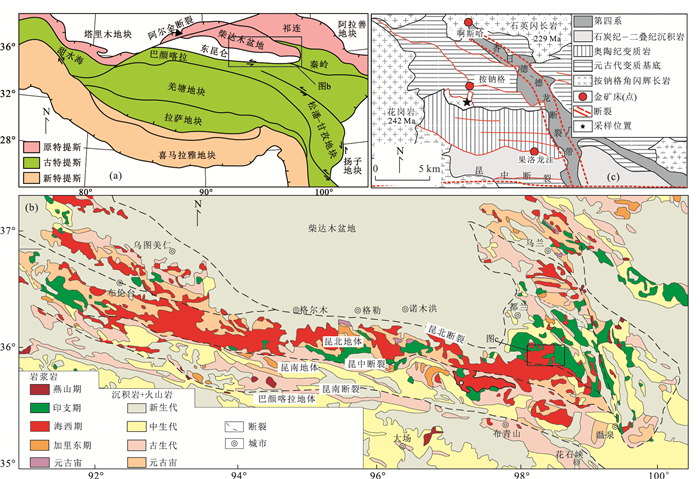
At present, the research on Permian-Triassic basic magmatic rocks in East Kunlun orogenic belt is extremely weak, which not only limits the understanding of the nature of the mantle source in the study area during this period but also restricts the accurate understanding of the evolution processes of Paleo-Tethys Ocean.The zircon LA-ICP-MS U-Pb geochronology and major and trace elements, as well as Sr-Nd-Hf isotope geochemistry of the An'nage hornblende gabbro in the East Kunlun orogenic belt are applied in this paper.LA-ICP-MS zircon U-Pb dating yields a weighted mean age of 242±2 Ma for the intrusion.It is characterized by low SiO2(46.00%-52.40%), low(Na2O+K2O)(3.07%-3.79%) contents.In addition, it is enriched in Al2O3(17.35%-20.10%), MgO(4.65%-6.53%) and FeOT(8.77%-11.07%) with high Mg#(68-75), indicating that it belongs to the calc-alkaline series.This intrusion has low(La/Yb)N and Nb/Ta ratios, negative Eu anomalies, with enriched large-ion lithophile elements and depleted high field strength elements.All geochemical characteristics show that this intrusion is the result of typical island arc magmatic activity.Additionally, the samples have relatively uniform(87Sr/86Sr)i ratios(0.708 80-0.710 36) and εNd(t) values(-4.8 to -3.4), and relatively high εHf(t) values(-4.9 to -0.4).According to the lithology, geochemical characteristics and isotopic compositions of the intrusion, we propose that the magma has not been significantly contaminated by the crust and it was derived from the low-degree partial melting(2%-10%) of the mantle wedge, which had undergone metasomatism induced by the fluid from the subducted slab.The mantle source was characterized by the spinel phase-phlogopite lherzolite.Slight fractional crystallization of pyroxene and plagioclase might also occur during the evolution of magma.In combination with the tectonic evolution of the East Kunlun orogenic belt and the geochronological and geochemical characteristics of contemporary intrusive rocks, it is concluded that the An'nage hornblende gabbro was produced at the late stage of Paleo-Tethys Ocean subduction, and the final closure timing of Paleo-Tethys Ocean should be the Middle Triassic to Late Triassic.
At present, the research on Permian-Triassic basic magmatic rocks in East Kunlun orogenic belt is extremely weak, which not only limits the understanding of the nature of the mantle source in the study area during this period but also restricts the accurate understanding of the evolution processes of Paleo-Tethys Ocean.The zircon LA-ICP-MS U-Pb geochronology and major and trace elements, as well as Sr-Nd-Hf isotope geochemistry of the An'nage hornblende gabbro in the East Kunlun orogenic belt are applied in this paper.LA-ICP-MS zircon U-Pb dating yields a weighted mean age of 242±2 Ma for the intrusion.It is characterized by low SiO2(46.00%-52.40%), low(Na2O+K2O)(3.07%-3.79%) contents.In addition, it is enriched in Al2O3(17.35%-20.10%), MgO(4.65%-6.53%) and FeOT(8.77%-11.07%) with high Mg#(68-75), indicating that it belongs to the calc-alkaline series.This intrusion has low(La/Yb)N and Nb/Ta ratios, negative Eu anomalies, with enriched large-ion lithophile elements and depleted high field strength elements.All geochemical characteristics show that this intrusion is the result of typical island arc magmatic activity.Additionally, the samples have relatively uniform(87Sr/86Sr)i ratios(0.708 80-0.710 36) and εNd(t) values(-4.8 to -3.4), and relatively high εHf(t) values(-4.9 to -0.4).According to the lithology, geochemical characteristics and isotopic compositions of the intrusion, we propose that the magma has not been significantly contaminated by the crust and it was derived from the low-degree partial melting(2%-10%) of the mantle wedge, which had undergone metasomatism induced by the fluid from the subducted slab.The mantle source was characterized by the spinel phase-phlogopite lherzolite.Slight fractional crystallization of pyroxene and plagioclase might also occur during the evolution of magma.In combination with the tectonic evolution of the East Kunlun orogenic belt and the geochronological and geochemical characteristics of contemporary intrusive rocks, it is concluded that the An'nage hornblende gabbro was produced at the late stage of Paleo-Tethys Ocean subduction, and the final closure timing of Paleo-Tethys Ocean should be the Middle Triassic to Late Triassic.


2018, 43(2): 371-388.
doi: 10.3799/dqkx.2018.021
Abstract:
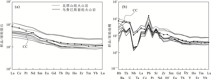
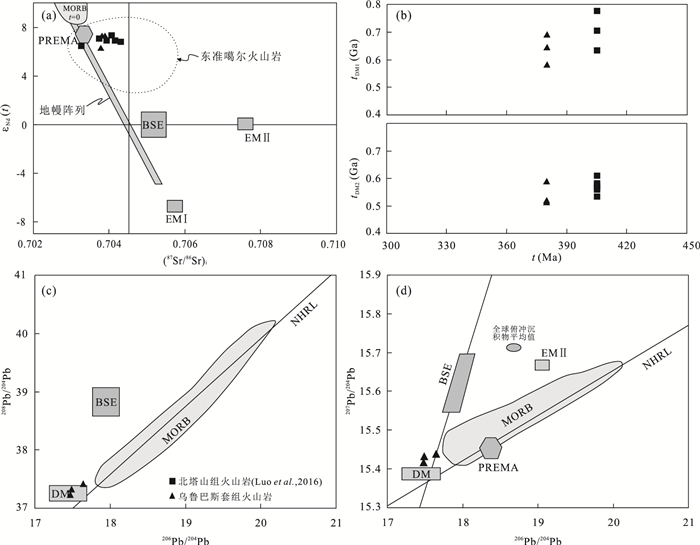
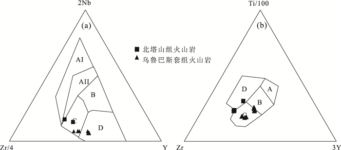
The East Junggar has always been one of study hotspots on the Paleozoic ocean-continent transformation and tectonic evolution of the northern Xinjiang.However, studies of volcanic rocks in the south margin of the East Junggar are relatively weak since studies focus more on the origin and structural attributes of Carboniferous volcanic rocks, resulting in a lack of understanding of the tectonic setting and magmatic evolution of the Devonian volcanic rocks.Here we report a detailed petrologic, geochemical and geochronologic analyses on the Devonian volcanic rocks from the Beitashan and Wulubasitao Formations in the northern of the Karamaili ophiolite, to examine its formation environment and magma origin.Combining with the previous works in this region, our study reveals that the volcanic rocks of the Beitashan Formation from the Karamaili formed during the Early Devonian to Middle Devonian (404 Ma), which is characterized by intermediate-high K, Ti and Fe, low Al2O3 levels, enriched in LREE and LILE, and relatively depleted in HFSE (Nb, Ta).These rocks was probably formed in a continental marginal arc construction environment and the magma is originated from a depleted mantle wedge metasomatismed by melt and fluid from subduction sediment.For the Wulubasitao Formation, the volcanic rocks formed during the Middle Devonian (MoQinulla), characterized by poor alkali, low K, Ti, Fe and high Al, indicating typical island arc volcanic rocks.Isotope and trace element characteristics show it was derived from depleted mantle wedge metasomatismed by fluid from subducted plate.According to the differences of two volcanic rocks features as well as regional geology, we speculate that the subduction of the Karamaili ocean transformed from continental marginal arc to island arc during the Middle Devonian.
The East Junggar has always been one of study hotspots on the Paleozoic ocean-continent transformation and tectonic evolution of the northern Xinjiang.However, studies of volcanic rocks in the south margin of the East Junggar are relatively weak since studies focus more on the origin and structural attributes of Carboniferous volcanic rocks, resulting in a lack of understanding of the tectonic setting and magmatic evolution of the Devonian volcanic rocks.Here we report a detailed petrologic, geochemical and geochronologic analyses on the Devonian volcanic rocks from the Beitashan and Wulubasitao Formations in the northern of the Karamaili ophiolite, to examine its formation environment and magma origin.Combining with the previous works in this region, our study reveals that the volcanic rocks of the Beitashan Formation from the Karamaili formed during the Early Devonian to Middle Devonian (404 Ma), which is characterized by intermediate-high K, Ti and Fe, low Al2O3 levels, enriched in LREE and LILE, and relatively depleted in HFSE (Nb, Ta).These rocks was probably formed in a continental marginal arc construction environment and the magma is originated from a depleted mantle wedge metasomatismed by melt and fluid from subduction sediment.For the Wulubasitao Formation, the volcanic rocks formed during the Middle Devonian (MoQinulla), characterized by poor alkali, low K, Ti, Fe and high Al, indicating typical island arc volcanic rocks.Isotope and trace element characteristics show it was derived from depleted mantle wedge metasomatismed by fluid from subducted plate.According to the differences of two volcanic rocks features as well as regional geology, we speculate that the subduction of the Karamaili ocean transformed from continental marginal arc to island arc during the Middle Devonian.


2018, 43(2): 389-400.
doi: 10.3799/dqkx.2017.597
Abstract:
The Early Paleozoic high pressure (HP) to ultrahigh pressure (UHP) metamorphism in the North Qinling (NQ) terrane preserves the oldest UHP record in the whole Qinling-Tongbai-Hong'an-Dabie-Sulu orogenic belt and thus registers the first accretionary collision process between the South China block (SCB) and the North China block (NCB).However, its evolution processes remain the subject of heated debate.This paper presents an integrated study of CL image, trace elements, and U-Pb age of zircons from a felsic vein within a UHP eclogite outcrop from the Guanpo area, NQ terrane.Zircons from the vein are euhedral in shape, displaying oscillatory, planar or no zoning, high U but low Th contents resulting in low Th/U ratios, indicating that they precipitated from hydrous melts responsible for the vein formation.In addition, these metamorphic zircons are characterized by low LREE contents, relatively high HREE patterns, and significant negative Eu anomalies, suggesting the hydrous melts formed during the amphibolite-facies retrogression.The weighted mean 206Pb/238U age of 494±10 Ma of these zircons is similar to the age of the peak UHP metamorphism (490.4±5.8 Ma) of the NQ unit, within the analytical error.Based on the above observations, we suggest that the NQ terrane underwent fast exhumation after deep subduction in the Early Paleozoic, and released hydrous melts derived from partial melting during exhumation, which was triggered by the significant amphibolite-faices retrogression.
The Early Paleozoic high pressure (HP) to ultrahigh pressure (UHP) metamorphism in the North Qinling (NQ) terrane preserves the oldest UHP record in the whole Qinling-Tongbai-Hong'an-Dabie-Sulu orogenic belt and thus registers the first accretionary collision process between the South China block (SCB) and the North China block (NCB).However, its evolution processes remain the subject of heated debate.This paper presents an integrated study of CL image, trace elements, and U-Pb age of zircons from a felsic vein within a UHP eclogite outcrop from the Guanpo area, NQ terrane.Zircons from the vein are euhedral in shape, displaying oscillatory, planar or no zoning, high U but low Th contents resulting in low Th/U ratios, indicating that they precipitated from hydrous melts responsible for the vein formation.In addition, these metamorphic zircons are characterized by low LREE contents, relatively high HREE patterns, and significant negative Eu anomalies, suggesting the hydrous melts formed during the amphibolite-facies retrogression.The weighted mean 206Pb/238U age of 494±10 Ma of these zircons is similar to the age of the peak UHP metamorphism (490.4±5.8 Ma) of the NQ unit, within the analytical error.Based on the above observations, we suggest that the NQ terrane underwent fast exhumation after deep subduction in the Early Paleozoic, and released hydrous melts derived from partial melting during exhumation, which was triggered by the significant amphibolite-faices retrogression.


2018, 43(2): 401-416.
doi: 10.3799/dqkx.2017.599
Abstract:
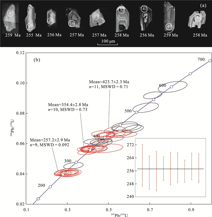
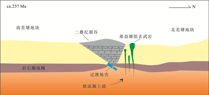
The Nayixiong Formation basalts in the eastern Qiangtang basin were the eruption products of the last stage of rift evolution, and their diagenetic age and geochemical characteristics provided important constraints for the closure time of the rift and the tectonic evolution of the Permian. Based on the profile geological survey, LA-ICP-MS zircon U-Pb dating and whole rock analysis of the Nayixiong Formation basalts were carried out in this study. Nayixiong Formation basalt samples yield the concordant age with a weighted mean 206Pb/238U age of 257.2±2.9 Ma. The geochemical characteristics of the basalts show a tholeiitic basalt affinity, with slight enrichment of Ta and slight negative Nb anomalies, as well as exhibiting no Eu-anomalies. The Nayixiong Formation basalts were likely resulted from the interaction between the upwelling asthenosphere and the lithospheric mantle that formed by the predated underplating. we propose that the basalts formed in an extensional setting after the closure of the Permian rift. All of the Permian basalts geochemical data show a transitional trend that the Early Permian-Late Permian basalts gradually evolved from OIB continental basalt to volcanic arc basalt, demonstating that the Permian rift undergoing the opening, rifting and closing from Early Permian to Late Permian in eastern Qiangtang terrane. The Nayixiong Formation basalts formed in an extensional setting after the amalgamation of intra-plate rift, confirming that the Qiangtang terrane was a tectonic transitional phase experiencing extension and closure of intra-plate rift (limited ocean) in the Late Permian.
The Nayixiong Formation basalts in the eastern Qiangtang basin were the eruption products of the last stage of rift evolution, and their diagenetic age and geochemical characteristics provided important constraints for the closure time of the rift and the tectonic evolution of the Permian. Based on the profile geological survey, LA-ICP-MS zircon U-Pb dating and whole rock analysis of the Nayixiong Formation basalts were carried out in this study. Nayixiong Formation basalt samples yield the concordant age with a weighted mean 206Pb/238U age of 257.2±2.9 Ma. The geochemical characteristics of the basalts show a tholeiitic basalt affinity, with slight enrichment of Ta and slight negative Nb anomalies, as well as exhibiting no Eu-anomalies. The Nayixiong Formation basalts were likely resulted from the interaction between the upwelling asthenosphere and the lithospheric mantle that formed by the predated underplating. we propose that the basalts formed in an extensional setting after the closure of the Permian rift. All of the Permian basalts geochemical data show a transitional trend that the Early Permian-Late Permian basalts gradually evolved from OIB continental basalt to volcanic arc basalt, demonstating that the Permian rift undergoing the opening, rifting and closing from Early Permian to Late Permian in eastern Qiangtang terrane. The Nayixiong Formation basalts formed in an extensional setting after the amalgamation of intra-plate rift, confirming that the Qiangtang terrane was a tectonic transitional phase experiencing extension and closure of intra-plate rift (limited ocean) in the Late Permian.


2018, 43(2): 417-435.
doi: 10.3799/dqkx.2018.022
Abstract:
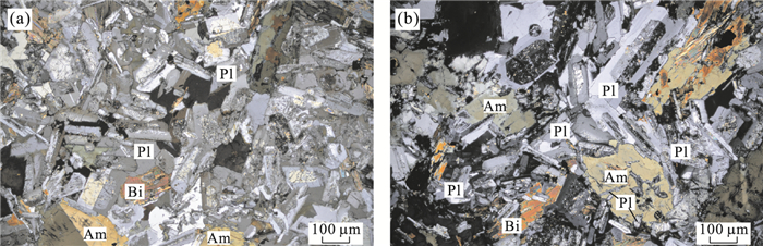
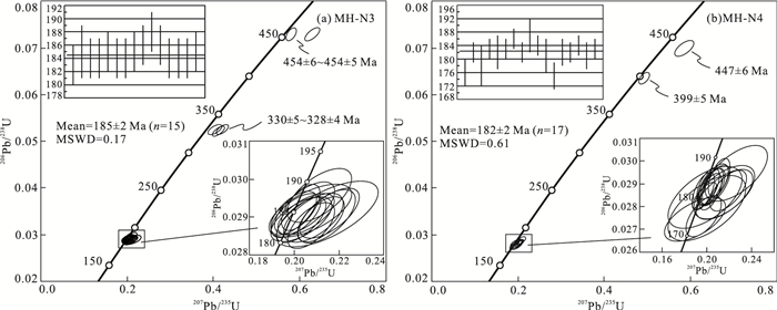
Previous studies are mostly concentrated on the biotite granodiorites exposed during the Indosinian period in southern Mohe county, while the research on the Early Yanshanian tectonic evolution in this area is relatively weak. This paper presents new zircon U-Pb dating, Hf isotope, major and trace elements for biotite granodiorites in southern Mohe County for the discussion in their geochronology, magma sources and tectonic setting. Zircon dating results demonstrate that biotite granodiorites were formed in Early Jurassic (185±2 Ma and 182±2 Ma). Geochemically, these rocks have A/CNK=0.90~1.03, Mg#=42~48, belonging to the high-K calc-alkaline series. The pluton has features similar to adakitic rock with high Sr (489×10-6~653×10-6) and low Yb (1.33×10⁻⁶~1.99×10⁻⁶). They have the geochemistry of arc magmatic rocks, which are enriched LREE and LILE (e.g., Rb and K), depleted HREE and HFSE (e.g., Nb, Ta and Ti), as well as very weak negative Eu anomalies (Eu/Eu*=0.79~0.95), indicating that the magma source was derived from the partial melting of lower crust. Zircon εHf(t) values and two-stage Hf model ages (tDM2) of doitite granodoirites range from -3.26 to-1.46 and 1.25 Ga to 1.59 Ga, respectively, indicative of formation from primary magmas generated by partial melting of thickened low crust that formed from the depleted mantle during the Meso-to Neoproterozoic. Considering the regional tectonic revolution, we suggest that the diotite granodiorite was formed in the setting of continuous southward subduction of Mongol-Okhotsk oceanic plate during the Early Mesozoic.
Previous studies are mostly concentrated on the biotite granodiorites exposed during the Indosinian period in southern Mohe county, while the research on the Early Yanshanian tectonic evolution in this area is relatively weak. This paper presents new zircon U-Pb dating, Hf isotope, major and trace elements for biotite granodiorites in southern Mohe County for the discussion in their geochronology, magma sources and tectonic setting. Zircon dating results demonstrate that biotite granodiorites were formed in Early Jurassic (185±2 Ma and 182±2 Ma). Geochemically, these rocks have A/CNK=0.90~1.03, Mg#=42~48, belonging to the high-K calc-alkaline series. The pluton has features similar to adakitic rock with high Sr (489×10-6~653×10-6) and low Yb (1.33×10⁻⁶~1.99×10⁻⁶). They have the geochemistry of arc magmatic rocks, which are enriched LREE and LILE (e.g., Rb and K), depleted HREE and HFSE (e.g., Nb, Ta and Ti), as well as very weak negative Eu anomalies (Eu/Eu*=0.79~0.95), indicating that the magma source was derived from the partial melting of lower crust. Zircon εHf(t) values and two-stage Hf model ages (tDM2) of doitite granodoirites range from -3.26 to-1.46 and 1.25 Ga to 1.59 Ga, respectively, indicative of formation from primary magmas generated by partial melting of thickened low crust that formed from the depleted mantle during the Meso-to Neoproterozoic. Considering the regional tectonic revolution, we suggest that the diotite granodiorite was formed in the setting of continuous southward subduction of Mongol-Okhotsk oceanic plate during the Early Mesozoic.


2018, 43(2): 436-448.
doi: 10.3799/dqkx.2017.572
Abstract:
The tectonic setting is complex while Jurassic granite is relatively limited in the Badaogou area, which results in a lack of theoretical basis for its regional tectonic evolution studies. This paper presents a synthesis of geochemical and zircon U-Pb chronological and Hf isotopic study on the Badaogou monzonitic granites. The zircons of rock samples which have distinct rhythmic growth zoning are long cylindrical and euhedral well-formed, implying the features of magmatic origin. Dating results indicate that the rocks were formed in the Early Jurassic (176±1 Ma). The rocks which obviously are rich in LREE and have unconspicuous europium anomalies (0.96-1.03) with regard to high SiO2 (68.93%-70.02%), low MgO (1.27%-1.45%), CaO (1.80%-2.78%) as well as A/CNK (0.92-1.02) belong to sub-aluminous and high-K calc-alkaline granites, being of the characteristics of Ⅰ-type granites. The εHf(t) values vary from -20.21 to -24.08, and the two-stage model age (tDM2) ranges from 2 498 to 2 740 Ma. These samples are enriched in LILE and depleted in HFSE (such as Nb, Ta, P, Ti), with Mg# values of 45-47. Analyses show that the rocks came from the melting of neo-Archean lower crust. Combining with the background of regional contemporary magmatic distribution, it is concluded that the formation of monzonotic granites from Badaogou could be related to the subduction of the Paleo-Pacific plate under the Eurasian continent.
The tectonic setting is complex while Jurassic granite is relatively limited in the Badaogou area, which results in a lack of theoretical basis for its regional tectonic evolution studies. This paper presents a synthesis of geochemical and zircon U-Pb chronological and Hf isotopic study on the Badaogou monzonitic granites. The zircons of rock samples which have distinct rhythmic growth zoning are long cylindrical and euhedral well-formed, implying the features of magmatic origin. Dating results indicate that the rocks were formed in the Early Jurassic (176±1 Ma). The rocks which obviously are rich in LREE and have unconspicuous europium anomalies (0.96-1.03) with regard to high SiO2 (68.93%-70.02%), low MgO (1.27%-1.45%), CaO (1.80%-2.78%) as well as A/CNK (0.92-1.02) belong to sub-aluminous and high-K calc-alkaline granites, being of the characteristics of Ⅰ-type granites. The εHf(t) values vary from -20.21 to -24.08, and the two-stage model age (tDM2) ranges from 2 498 to 2 740 Ma. These samples are enriched in LILE and depleted in HFSE (such as Nb, Ta, P, Ti), with Mg# values of 45-47. Analyses show that the rocks came from the melting of neo-Archean lower crust. Combining with the background of regional contemporary magmatic distribution, it is concluded that the formation of monzonotic granites from Badaogou could be related to the subduction of the Paleo-Pacific plate under the Eurasian continent.


2018, 43(2): 449-458.
doi: 10.3799/dqkx.2017.579
Abstract:
Dolomite is a widespread carbonate mineral in sedimentary rocks, and its formation mechanism have always attracted much attention. Most modern dolomite occurred in hypersaline environments and several microbial isolates from these environments have been reported to be able to induce dolomite formation as well. However the detailed mechanism of microbial induced dolomite remains largely unclear to date. In this study, a halophilic archaea, Natrinema sp. J7-1, was used to investigate what exactly played an important role in the microbial dolomite formation. Normal cells of Natrinema sp. J7-1 in post-log phase, inactive cells treated with carbonyl cyanide 3-cholorophenylhydrazine (CCCP, amitochondrial inhibitor), denatured cells treated by paraformaldehyde and glutaraldehyde, as well as carboxylated microspheres were used to induce dolomite formation. The mineral phases were identified by X-ray Diffraction(XRD), the morphologies of minerals, cells and microspheres were observed by Scanning Electron Microscope(SEM) and the functional groups on the surface of normal cells and denatured cells were analyzed by Fourier Transform Infrared Spectroscopy(FT-IR). Results showed that normal cells, inactive cells and carboxylated microspheres induced proto-dolomite formation successfully at the salinity of 280‰. In contrast, denatured cells were not capable of inducing the formation of dolomite, and the percentage of carboxyl groups on their surface decreased compared with normal cells. It can be concluded that carboxyl is one critical factor for microbially mediated dolomite formation, but respiration may count for little under our conditions.
Dolomite is a widespread carbonate mineral in sedimentary rocks, and its formation mechanism have always attracted much attention. Most modern dolomite occurred in hypersaline environments and several microbial isolates from these environments have been reported to be able to induce dolomite formation as well. However the detailed mechanism of microbial induced dolomite remains largely unclear to date. In this study, a halophilic archaea, Natrinema sp. J7-1, was used to investigate what exactly played an important role in the microbial dolomite formation. Normal cells of Natrinema sp. J7-1 in post-log phase, inactive cells treated with carbonyl cyanide 3-cholorophenylhydrazine (CCCP, amitochondrial inhibitor), denatured cells treated by paraformaldehyde and glutaraldehyde, as well as carboxylated microspheres were used to induce dolomite formation. The mineral phases were identified by X-ray Diffraction(XRD), the morphologies of minerals, cells and microspheres were observed by Scanning Electron Microscope(SEM) and the functional groups on the surface of normal cells and denatured cells were analyzed by Fourier Transform Infrared Spectroscopy(FT-IR). Results showed that normal cells, inactive cells and carboxylated microspheres induced proto-dolomite formation successfully at the salinity of 280‰. In contrast, denatured cells were not capable of inducing the formation of dolomite, and the percentage of carboxyl groups on their surface decreased compared with normal cells. It can be concluded that carboxyl is one critical factor for microbially mediated dolomite formation, but respiration may count for little under our conditions.


2018, 43(2): 459-474.
doi: 10.3799/dqkx.2017.512
Abstract:
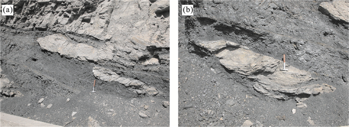
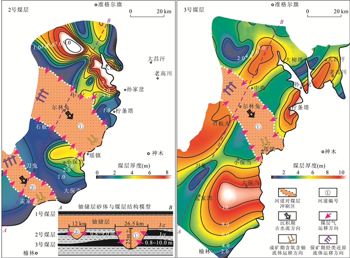
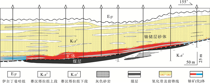
The Daying and Qianjiadian uranium deposits, the reductive media within uranium-bearing series are divided into inner reductive media and outer reductive media according to its occurrence relationship with uranium reservoir sandstone. The assemblage of the inner and outer reductive media was in favor of the formation of the interlayer oxidation zone and continuous uranium mineralization. It is found that the interlayer oxidation within uranium reservoir sandstone was directly related with the inner reductive media and the reducibility of uranium reservoir sandstone was largely enhanced when the outer reductive media participated in the process of interlayer oxidation. The reductive media outside uranium reservoir sandstone was just as important to uranium mineralization as the reductive media inside uranium reservoir sandstone. Types and abundance of the reductive media inside and outside uranium reservoir sandstone and their spatial distribution were affected by the synsedimentary palaeoclimate and depositional environment of uranium-bearing series which basically constrained the scale of interlayer oxidation zone. The desired results will be achieved during prospecting prediction for the sandstone-type uranium deposit based on evaluation of the model of the double reductive media associated with the studies of geological background and ore-controlling conditions in the uranium mineralization stage.
The Daying and Qianjiadian uranium deposits, the reductive media within uranium-bearing series are divided into inner reductive media and outer reductive media according to its occurrence relationship with uranium reservoir sandstone. The assemblage of the inner and outer reductive media was in favor of the formation of the interlayer oxidation zone and continuous uranium mineralization. It is found that the interlayer oxidation within uranium reservoir sandstone was directly related with the inner reductive media and the reducibility of uranium reservoir sandstone was largely enhanced when the outer reductive media participated in the process of interlayer oxidation. The reductive media outside uranium reservoir sandstone was just as important to uranium mineralization as the reductive media inside uranium reservoir sandstone. Types and abundance of the reductive media inside and outside uranium reservoir sandstone and their spatial distribution were affected by the synsedimentary palaeoclimate and depositional environment of uranium-bearing series which basically constrained the scale of interlayer oxidation zone. The desired results will be achieved during prospecting prediction for the sandstone-type uranium deposit based on evaluation of the model of the double reductive media associated with the studies of geological background and ore-controlling conditions in the uranium mineralization stage.


2018, 43(2): 475-490.
doi: 10.3799/dqkx.2018.023
Abstract:
The evolution of Rodinia surpercontinent has always been of concern as an important scientific issue. Paleobiogeographic region analysis, as an effective method to solve the problem of the tectonic reconstruction of the continental masses, has rarely been applied to Rodinia. Longfengshan biota, characterized by Chuaria-Tawuia-Longfengshania, is one of the typical biota, whose biotic factor can be found globally, in the nearshore shallow water basin and Lagoon, Tonian. According to the reliable existing biota data reported globally, we make the paleobiogeographic analysis, zoning them into North China Craton-North Laurentia region(Chuaria-Tawuia-Longfengshania) and Yangtze Craton-India Craton region (Chuaria-Tawuia), constitute a low-latitude-Macroalgae realm (1 000-780 Ma). Furthermore, we have a new cognition on the position of North China Craton, in the east of Rodinia surpercontinent, near Laurentia Craton, and Yangtze Craton in the west, close to India Craton.
The evolution of Rodinia surpercontinent has always been of concern as an important scientific issue. Paleobiogeographic region analysis, as an effective method to solve the problem of the tectonic reconstruction of the continental masses, has rarely been applied to Rodinia. Longfengshan biota, characterized by Chuaria-Tawuia-Longfengshania, is one of the typical biota, whose biotic factor can be found globally, in the nearshore shallow water basin and Lagoon, Tonian. According to the reliable existing biota data reported globally, we make the paleobiogeographic analysis, zoning them into North China Craton-North Laurentia region(Chuaria-Tawuia-Longfengshania) and Yangtze Craton-India Craton region (Chuaria-Tawuia), constitute a low-latitude-Macroalgae realm (1 000-780 Ma). Furthermore, we have a new cognition on the position of North China Craton, in the east of Rodinia surpercontinent, near Laurentia Craton, and Yangtze Craton in the west, close to India Craton.


2018, 43(2): 491-501.
doi: 10.3799/dqkx.2018.024
Abstract:
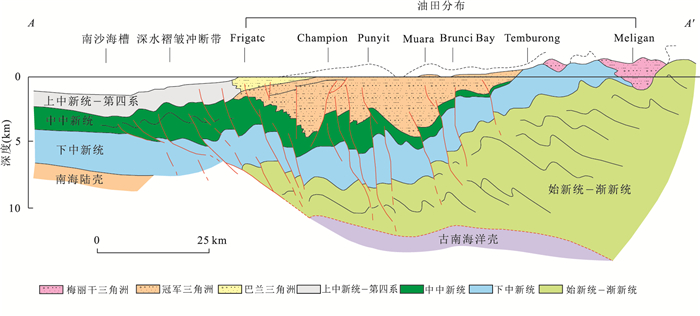
The structure and characteristics of deepwater fold and thrust belts (DFTBs) can change with time and thus affect the exploration and development of deepwater oil and gas, while the research on this aspect is relatively weak in the DFTBs of NW Borneo. Based on the combination method of seismic and geology, this paper determines the structural patterns of thrust-related folds, discusses the formation process and controlling factors, establishes the accumulation model of thrust-related folds in the study area. The results show that four types of structural patterns of thrust-related folds develop in the DFTBs of NW Borneo, namely, hidden type, crest faulted type, slump type and buried type, and on the planar the above four type thrust-related folds successively distribute from sea to land. The amplitude of anticline fold of hidden type is relatively low, with no obvious seafloor expression, mainly forming in the foremost of DFTBs. The crest faulted type is characterized by the development of faults in the crest of anticline, with apparent seafloor relief. The crest of slump type anticline is influenced by the normal faults, with flanks associated with slides and slumps. The buried type anticlines mainly develop close to the shelf margin, buried by a thick sedimentary overburden, with no prominent seafloor expression. Four type thrust-related folds structures stage, with hidden type, crest faulted type, slump type and buried type anticline, successively developed. At the same time, if viewed along the strike of the DFTBs, there are significant variations in the geometry of laterally corresponding thrust-related folds under the same compression, controlled by the topography, differential sediment input and the development of subsurface gas hydrates. Under this special tectonic background, a unique fault-controlled accumulation model forms in the study area, with favorable exploration potential.
The structure and characteristics of deepwater fold and thrust belts (DFTBs) can change with time and thus affect the exploration and development of deepwater oil and gas, while the research on this aspect is relatively weak in the DFTBs of NW Borneo. Based on the combination method of seismic and geology, this paper determines the structural patterns of thrust-related folds, discusses the formation process and controlling factors, establishes the accumulation model of thrust-related folds in the study area. The results show that four types of structural patterns of thrust-related folds develop in the DFTBs of NW Borneo, namely, hidden type, crest faulted type, slump type and buried type, and on the planar the above four type thrust-related folds successively distribute from sea to land. The amplitude of anticline fold of hidden type is relatively low, with no obvious seafloor expression, mainly forming in the foremost of DFTBs. The crest faulted type is characterized by the development of faults in the crest of anticline, with apparent seafloor relief. The crest of slump type anticline is influenced by the normal faults, with flanks associated with slides and slumps. The buried type anticlines mainly develop close to the shelf margin, buried by a thick sedimentary overburden, with no prominent seafloor expression. Four type thrust-related folds structures stage, with hidden type, crest faulted type, slump type and buried type anticline, successively developed. At the same time, if viewed along the strike of the DFTBs, there are significant variations in the geometry of laterally corresponding thrust-related folds under the same compression, controlled by the topography, differential sediment input and the development of subsurface gas hydrates. Under this special tectonic background, a unique fault-controlled accumulation model forms in the study area, with favorable exploration potential.


2018, 43(2): 502-513.
doi: 10.3799/dqkx.2017.596
Abstract:
Xihu depression is the most important petroliferous structural units, and the Huagang Formation is the major target stratum for petroleum exploration in the East China Sea shelf basin. However, the prototype basin type of Huagang period is still controversial and lack of persuasive evidences up till now. According to the 2D seismic data interpretation, the system analysis of key surfaces' features, basin infilling geometry, basin transforming and erosion, it is proposed that the Huagang prototype basin is a large-scale compressional depression. The T30 seismic reflector, which acts as the initial surface of Huagang prototype basin, represents a regional uplift-erosion unconformity under compressional background. The T20 seismic reflector, which acts as the transforming surface of Huagang prototype basin, mainly stands for a regional uplift-erosion unconformity controlled by the uplifting activities of Diaoyu Dao folded-uplift belt. Further, the formation and evolutionary model of Huagang prototype basin is established.
Xihu depression is the most important petroliferous structural units, and the Huagang Formation is the major target stratum for petroleum exploration in the East China Sea shelf basin. However, the prototype basin type of Huagang period is still controversial and lack of persuasive evidences up till now. According to the 2D seismic data interpretation, the system analysis of key surfaces' features, basin infilling geometry, basin transforming and erosion, it is proposed that the Huagang prototype basin is a large-scale compressional depression. The T30 seismic reflector, which acts as the initial surface of Huagang prototype basin, represents a regional uplift-erosion unconformity under compressional background. The T20 seismic reflector, which acts as the transforming surface of Huagang prototype basin, mainly stands for a regional uplift-erosion unconformity controlled by the uplifting activities of Diaoyu Dao folded-uplift belt. Further, the formation and evolutionary model of Huagang prototype basin is established.


2018, 43(2): 514-524.
doi: 10.3799/dqkx.2017.588
Abstract:
Canyon channel is the main reservoir of the deepwater area in Qiongdongnan basin in the northern South China Sea. Reservoir stones have good physical properties since they are dominated by powder and fine sandstones. However, there are few studies on the main provenance supply, nature of the parent rock area in different periods of channel formation, and paleo-weathering degree. In this study, it is found that the rock types are mainly debris-quartz sandstone and feldspar-debris sandstone.The heavy mineral assemblages show that they are dominated by magnetite, ilmenite, zircon and tourmaline in Yacheng area, whereas they are dominated by ilmenite, garnet, tourmaline and zircon in Lingshui area. Geochemical characteristics of mudstone show significantly lower SiO2 content, but higher Fe2O3, MgO, K2O and the total amount of rare earth contents relating to high clay minerals than sandstone. Al2O3/TiO2, K2O/Al2O3 and K2O/Na2O ratios in mudstone and sandstone indicate that the source area is enriched in quartz and depleted in potassium feldspar, and is of quartz sediment source, and neutral igneous rock source respectively. The sandstone is characterized with higher SiO2/Al2O3 ratio, lower ICV, CIA and CIW values compared to mudstone, indicating that the source regions have experienced low to moderate weathering, and they are the deposition of recirculation in the stable tectonic environment, whereas the formation environment of mudstone is more active.
Canyon channel is the main reservoir of the deepwater area in Qiongdongnan basin in the northern South China Sea. Reservoir stones have good physical properties since they are dominated by powder and fine sandstones. However, there are few studies on the main provenance supply, nature of the parent rock area in different periods of channel formation, and paleo-weathering degree. In this study, it is found that the rock types are mainly debris-quartz sandstone and feldspar-debris sandstone.The heavy mineral assemblages show that they are dominated by magnetite, ilmenite, zircon and tourmaline in Yacheng area, whereas they are dominated by ilmenite, garnet, tourmaline and zircon in Lingshui area. Geochemical characteristics of mudstone show significantly lower SiO2 content, but higher Fe2O3, MgO, K2O and the total amount of rare earth contents relating to high clay minerals than sandstone. Al2O3/TiO2, K2O/Al2O3 and K2O/Na2O ratios in mudstone and sandstone indicate that the source area is enriched in quartz and depleted in potassium feldspar, and is of quartz sediment source, and neutral igneous rock source respectively. The sandstone is characterized with higher SiO2/Al2O3 ratio, lower ICV, CIA and CIW values compared to mudstone, indicating that the source regions have experienced low to moderate weathering, and they are the deposition of recirculation in the stable tectonic environment, whereas the formation environment of mudstone is more active.


2018, 43(2): 525-537.
doi: 10.3799/dqkx.2017.600
Abstract:
Developmental stages and mechanisms of the strike-slip faults on the northern slope of the Tarim basin remains controversial despite many studies. However, a more detailed study of the strike-slip faults in the area is possible due to the availability of high-quality 3D seismic data now. It is found that a series of strike-slip faults, which cut through the basement strata and straight up to the Middle Devonian strata, developed in the study area based on detailed 3D seismic interpretations. On the 3D seismic profiles, the strike-slip fault shows complex geometric feature that consists of a lower positive flower structure and an upper negative flower structure that is bounded by the Late Ordovician strata. On the seismic coherency slices, the lower strike-slip faults show NE linear extension and the upper strike-slip faults are NW trending and present right-order en-echelon arrangements. According to changes of the rising height of the interface and fault throw changes, the development history of the strike-slip faults may be divided into two stages including the Late Ordovician and the Middle Silurian-Middle Devonian. Combined with tectonic background analyses on the structures surrounding Tarim basin, the lower strike-slip faults and the upper en-echelon normal faults may be genetically linked. In the Late Ordovician, the Tazhong uplift experienced a strong compression from ancient Kunlun ocean subducting in NE direction, which resulted in the formation of NNE-trending strike-slip faults. During the Middle Silurian-Middle Devonian, intense folding orogeny of the Arkin tectonic domain caused the reactivation of the lower strike-slip faults and made the formation of the en-echelon normal faults was controlled by the early-stage basement weak zones.
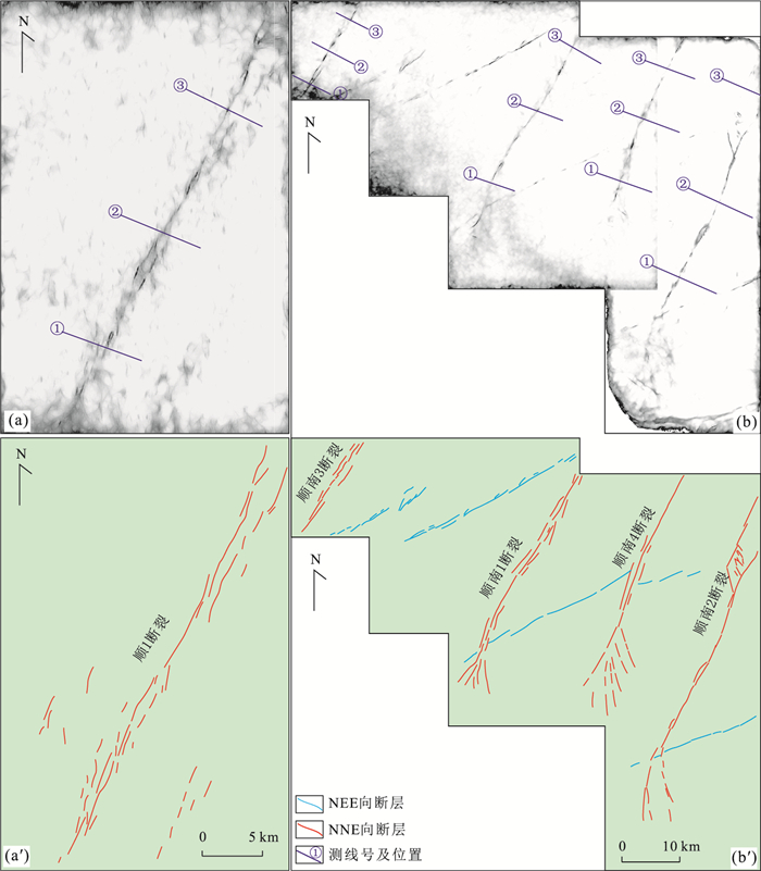
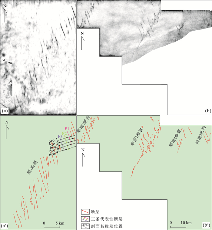
Developmental stages and mechanisms of the strike-slip faults on the northern slope of the Tarim basin remains controversial despite many studies. However, a more detailed study of the strike-slip faults in the area is possible due to the availability of high-quality 3D seismic data now. It is found that a series of strike-slip faults, which cut through the basement strata and straight up to the Middle Devonian strata, developed in the study area based on detailed 3D seismic interpretations. On the 3D seismic profiles, the strike-slip fault shows complex geometric feature that consists of a lower positive flower structure and an upper negative flower structure that is bounded by the Late Ordovician strata. On the seismic coherency slices, the lower strike-slip faults show NE linear extension and the upper strike-slip faults are NW trending and present right-order en-echelon arrangements. According to changes of the rising height of the interface and fault throw changes, the development history of the strike-slip faults may be divided into two stages including the Late Ordovician and the Middle Silurian-Middle Devonian. Combined with tectonic background analyses on the structures surrounding Tarim basin, the lower strike-slip faults and the upper en-echelon normal faults may be genetically linked. In the Late Ordovician, the Tazhong uplift experienced a strong compression from ancient Kunlun ocean subducting in NE direction, which resulted in the formation of NNE-trending strike-slip faults. During the Middle Silurian-Middle Devonian, intense folding orogeny of the Arkin tectonic domain caused the reactivation of the lower strike-slip faults and made the formation of the en-echelon normal faults was controlled by the early-stage basement weak zones.


2018, 43(2): 538-550.
doi: 10.3799/dqkx.2017.603
Abstract:
The lacustrine shale succession of the Permian Lucaogou Formation in southern Junggar basin, Northwest China, is the most important hydrocarbon source rock and an unconventional reservoir. However, there are relatively few studies on the deposition process of Lucaogou shale, the hydrologic conditions controlled by the paleoclimate, and the enrichment mechanism of organic matter in the shale. In this study, the Lucaogou shale was studied comprehensively, based on the results of its sedimentological and geochemical test data. Results show that the Lucaogou shale was deposited in a semi-deep to deep stratified lake, which has anoxic, highly saline bottom and oxic, less saline surface water. The lake catchment of the study area has climatic zonality, which presents as that the paleoclimate in the lake catchment of northeastern Bogda was warm and humid and the paleoclimate in the lake catchment of western Bogda was arid. Elevated precipitation in humid climate provides fresh water rich in nutrients to lake caused relatively high paleoproductivity and promotes lake stratification, which led to relatively high TOC in the Lucaogou shale of northeastern Bogda. Organic matter accumulation in the Lucaogou shale was influenced by surface water primary productivity and preservation in stable anoxic bottom water.
The lacustrine shale succession of the Permian Lucaogou Formation in southern Junggar basin, Northwest China, is the most important hydrocarbon source rock and an unconventional reservoir. However, there are relatively few studies on the deposition process of Lucaogou shale, the hydrologic conditions controlled by the paleoclimate, and the enrichment mechanism of organic matter in the shale. In this study, the Lucaogou shale was studied comprehensively, based on the results of its sedimentological and geochemical test data. Results show that the Lucaogou shale was deposited in a semi-deep to deep stratified lake, which has anoxic, highly saline bottom and oxic, less saline surface water. The lake catchment of the study area has climatic zonality, which presents as that the paleoclimate in the lake catchment of northeastern Bogda was warm and humid and the paleoclimate in the lake catchment of western Bogda was arid. Elevated precipitation in humid climate provides fresh water rich in nutrients to lake caused relatively high paleoproductivity and promotes lake stratification, which led to relatively high TOC in the Lucaogou shale of northeastern Bogda. Organic matter accumulation in the Lucaogou shale was influenced by surface water primary productivity and preservation in stable anoxic bottom water.


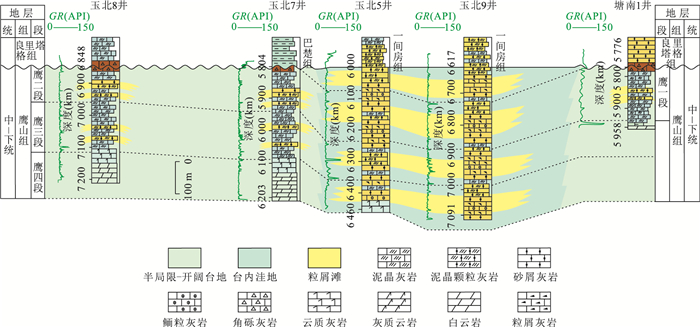
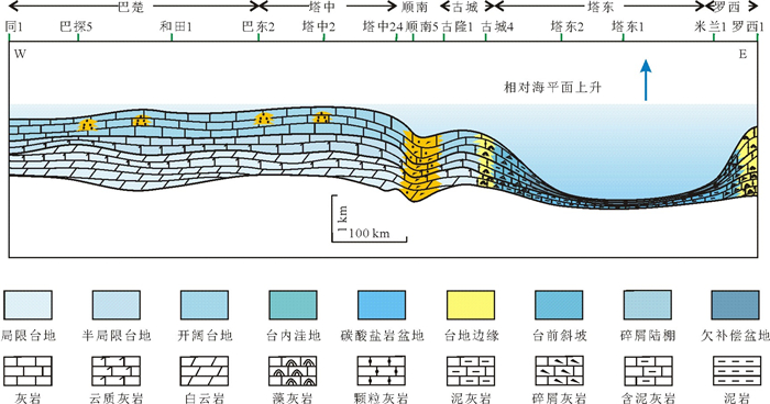
Tectonic-Depositional Environment and Petroleum Exploration of Yingshan Formation in the Tarim Basin
2018, 43(2): 551-565.
doi: 10.3799/dqkx.2017.509
Abstract:
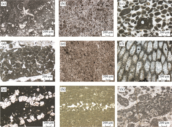
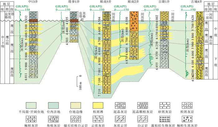
Prototype basin restoration is of great significance to uncover the original tectonics-lithofacies paleogeography of the basin and is the foundation of petroleum exploration. Based on the newest data of outcrops, drillings, and seismic profiles, with the thought of the combination of basins and orogenic belts, this paper analyzed the sedimentary filling by employing the method of "point → line → faces", reconstructed the tectonic-depositional environment of the Yingshan Formation in the Tarim basin and pointed out the exploration direction of the petroleum. The sedimentary pattern of the Yingshan Formation exhibited the feature of the east-west differentiation in the Tarim basin. Shallow platform facies was developed in the west of the Tarim basin and deep-water shale basin faceis was developed in the east of the Tarim basin. The sedimentary pattern of the Yingshan Formation also exhibited the differentiation in the Taxi platform. The subtidal high-energy bank facies was developed in the zone distributed along the Shunnan-Tanggubasi-Yudong and was altered by the storm wave intermittently. However, the other regions of the Taxi platform developed the combination of restricted tidal flat faceis and grain bank facies in the lower part of the Yingshan Formation and the combination of interbank sea faceis and intra-platform bank facies in the upper part of the Yingshan Formation. The tectonic environment of the Tarim basin experienced the transformation from the extension environment to the environment which was compression in the south and was extension in the north during this stage. The differentiation of the tectonic palaeogeography of the Taxi platform occurred because of the influence of the tectonic transformation. The intra-platform depression whose depth of water was above the wave base was developed along the Shunnan-Tanggubasi-Yudong and the intra-platform slope break belt was developed surrounding the intra-platform depression. The high-energy depositional environment was developed in the intra-platform depression, while the low-energy depositional environment was developed in the platform. The structure pattern differentiation of the Taxi platform was a response to the flexural deformation which was generated by the collision between the Tarim basin and the continental arc of North Kunlun and Altun during this stage. The southern part of the Tarim basin showed the characteristics of foreland basin. The foredeep part was developed in North Kunlun and North Altun, the forebulge part was developed in Tangnan and the back-bulge part was developed in Shunnan-Tanggubasi-Yudong.
Prototype basin restoration is of great significance to uncover the original tectonics-lithofacies paleogeography of the basin and is the foundation of petroleum exploration. Based on the newest data of outcrops, drillings, and seismic profiles, with the thought of the combination of basins and orogenic belts, this paper analyzed the sedimentary filling by employing the method of "point → line → faces", reconstructed the tectonic-depositional environment of the Yingshan Formation in the Tarim basin and pointed out the exploration direction of the petroleum. The sedimentary pattern of the Yingshan Formation exhibited the feature of the east-west differentiation in the Tarim basin. Shallow platform facies was developed in the west of the Tarim basin and deep-water shale basin faceis was developed in the east of the Tarim basin. The sedimentary pattern of the Yingshan Formation also exhibited the differentiation in the Taxi platform. The subtidal high-energy bank facies was developed in the zone distributed along the Shunnan-Tanggubasi-Yudong and was altered by the storm wave intermittently. However, the other regions of the Taxi platform developed the combination of restricted tidal flat faceis and grain bank facies in the lower part of the Yingshan Formation and the combination of interbank sea faceis and intra-platform bank facies in the upper part of the Yingshan Formation. The tectonic environment of the Tarim basin experienced the transformation from the extension environment to the environment which was compression in the south and was extension in the north during this stage. The differentiation of the tectonic palaeogeography of the Taxi platform occurred because of the influence of the tectonic transformation. The intra-platform depression whose depth of water was above the wave base was developed along the Shunnan-Tanggubasi-Yudong and the intra-platform slope break belt was developed surrounding the intra-platform depression. The high-energy depositional environment was developed in the intra-platform depression, while the low-energy depositional environment was developed in the platform. The structure pattern differentiation of the Taxi platform was a response to the flexural deformation which was generated by the collision between the Tarim basin and the continental arc of North Kunlun and Altun during this stage. The southern part of the Tarim basin showed the characteristics of foreland basin. The foredeep part was developed in North Kunlun and North Altun, the forebulge part was developed in Tangnan and the back-bulge part was developed in Shunnan-Tanggubasi-Yudong.


2018, 43(2): 566-576.
doi: 10.3799/dqkx.2018.025
Abstract:
The organic-rich lacustrine dolomitic mudstone, argillaceous dolomite, organic-poor siltstone and dolomite interlayer are important areas for shale oil exploration in terrestrial basins in China. However, the research on the integration of hydrocarbon generation, expulsion and hydrocarbon accumulation in the lacustrine organic-rich dolomitic mudstone or argillaceous dolomite under near geological conditions is still blank. An integrate experiment of hydrocarbon generation and expulsion simulation from argillaceous dolomite rich in organic matter under near geological condition in confined systems, has been carried out with typical lower mature organic-rich argillaceous dolomite. The four-stage of hydrocarbon generation and expulsion evolution model is revealed. The results show that the first stage is characterized by relatively slow oil generation associated hydrocarbon gases and by limited ability of oil expulsion when Ro is ≤ 0.74%. The second stage is characterized by rapid oil generation associated hydrocarbon gases and with incremental ability of oil expulsion when Ro is in the range of 0.74%-0.84%. The third stage is characterized by hydrocarbon gas generation associated oil and oil initial cracking, and by oil expulsion effectively at 0.84% < Ro ≤ 1.28%≈1.30%. The fourth stage is characterized by oil cracking into hydrocarbon gas associated hydrocarbon gases generation from kerogen when Ro is > 1.30%. And the retained oil is mainly occurred as adsorption phase with organic matter at Ro < 0.68%, and mainly occurred as free phase within micron to nano-scale pores and microfractures in mineral matrix of argillaceous dolomite at 0.68% ≤ Ro ≤ 2.00%. The range of thermal maturity for favorable shale oil exploration within lacustrine dolomite measures, is proposed at 0.84%-1.30%, on the basis of the results of simulation of hydrocarbon generation and expulsion for lacustrine organic-rich argillaceous dolomite, integrated with geological conditions and exploring economic benefit.
The organic-rich lacustrine dolomitic mudstone, argillaceous dolomite, organic-poor siltstone and dolomite interlayer are important areas for shale oil exploration in terrestrial basins in China. However, the research on the integration of hydrocarbon generation, expulsion and hydrocarbon accumulation in the lacustrine organic-rich dolomitic mudstone or argillaceous dolomite under near geological conditions is still blank. An integrate experiment of hydrocarbon generation and expulsion simulation from argillaceous dolomite rich in organic matter under near geological condition in confined systems, has been carried out with typical lower mature organic-rich argillaceous dolomite. The four-stage of hydrocarbon generation and expulsion evolution model is revealed. The results show that the first stage is characterized by relatively slow oil generation associated hydrocarbon gases and by limited ability of oil expulsion when Ro is ≤ 0.74%. The second stage is characterized by rapid oil generation associated hydrocarbon gases and with incremental ability of oil expulsion when Ro is in the range of 0.74%-0.84%. The third stage is characterized by hydrocarbon gas generation associated oil and oil initial cracking, and by oil expulsion effectively at 0.84% < Ro ≤ 1.28%≈1.30%. The fourth stage is characterized by oil cracking into hydrocarbon gas associated hydrocarbon gases generation from kerogen when Ro is > 1.30%. And the retained oil is mainly occurred as adsorption phase with organic matter at Ro < 0.68%, and mainly occurred as free phase within micron to nano-scale pores and microfractures in mineral matrix of argillaceous dolomite at 0.68% ≤ Ro ≤ 2.00%. The range of thermal maturity for favorable shale oil exploration within lacustrine dolomite measures, is proposed at 0.84%-1.30%, on the basis of the results of simulation of hydrocarbon generation and expulsion for lacustrine organic-rich argillaceous dolomite, integrated with geological conditions and exploring economic benefit.


2018, 43(2): 577-593.
doi: 10.3799/dqkx.2018.026
Abstract:
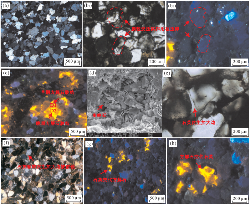
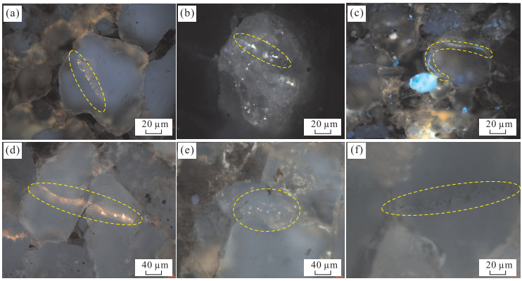
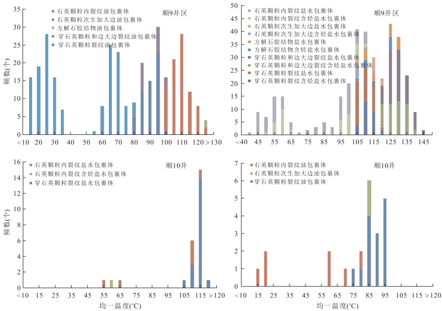
Hydrocarbon accumulations of Silurian had obvious differences between shun 10 and shun 9 well blocks due to the influence of multi-cycle tectonic activity in Shuntuoguole area of Tarim basin. Researchers used a variety of technical methods to conduct an in-depth study of the Silurian accumulation period in the study area, but no consensus has yet been reached. On the basis of diagenesis and diagenetic sequences, hydrocarbon filling sequence and charging history in shun 10 and shun 9 well blocks are determined by fluid inclusion system analysis and burial history projection combined with micro FT-IR, microscopic fluorescence and cathodeluminescence analysis in this study. Results show that the shun 9 well block displays three oil-charging stages including Late Caledonian (419.6-398.1 Ma), Late Hercynian (271.5-224.0 Ma) and the Himalayan (11.4-1.1 Ma), while shun 10 well block displays only two oil-charging stages including Late Caledonian (419.6-408.4 Ma) and Late Hercynian (271.6-236.8 Ma). 3D seismic interpretation of strata section and faults in shun 9 well block shows that, NE strike-slip faults in Tazhong northern slope are important migration system for hydrocarbon migration in the Silurian, which determines the industrial oil output in this area. Hence, the key target for hydrocarbon exploration in the Silurian lies in reservoirs charged in the Himalayan.
Hydrocarbon accumulations of Silurian had obvious differences between shun 10 and shun 9 well blocks due to the influence of multi-cycle tectonic activity in Shuntuoguole area of Tarim basin. Researchers used a variety of technical methods to conduct an in-depth study of the Silurian accumulation period in the study area, but no consensus has yet been reached. On the basis of diagenesis and diagenetic sequences, hydrocarbon filling sequence and charging history in shun 10 and shun 9 well blocks are determined by fluid inclusion system analysis and burial history projection combined with micro FT-IR, microscopic fluorescence and cathodeluminescence analysis in this study. Results show that the shun 9 well block displays three oil-charging stages including Late Caledonian (419.6-398.1 Ma), Late Hercynian (271.5-224.0 Ma) and the Himalayan (11.4-1.1 Ma), while shun 10 well block displays only two oil-charging stages including Late Caledonian (419.6-408.4 Ma) and Late Hercynian (271.6-236.8 Ma). 3D seismic interpretation of strata section and faults in shun 9 well block shows that, NE strike-slip faults in Tazhong northern slope are important migration system for hydrocarbon migration in the Silurian, which determines the industrial oil output in this area. Hence, the key target for hydrocarbon exploration in the Silurian lies in reservoirs charged in the Himalayan.


2018, 43(2): 594-598.
doi: 10.3799/dqkx.2018.027
Abstract:
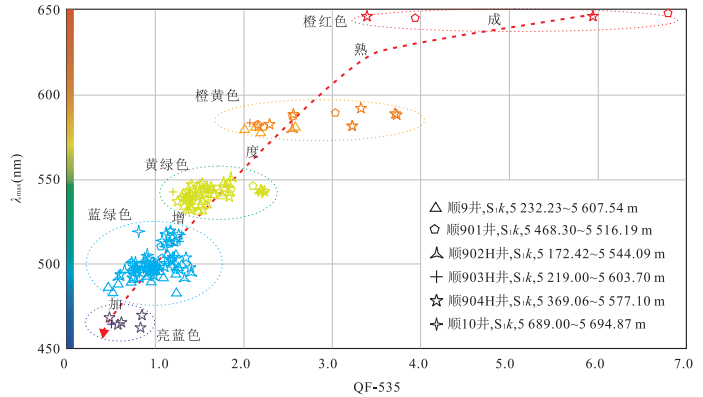
Based on the research of biomarker combined characteristics, oil and gas source, maturity and degree of secondary reconstruction could be discussed which is the effective method to analyses hydrocarbon origin, genesis of petroleum and oil-source correlation. By making the most of biomarker types and combined characteristics, the geochemical significance will be researched. Oil-source correlation had been studied by becteria degradation and biomarker combined characteristics. The distribution of n-alkanes and isoprene shows that various types of crude oil are developed. That is, two main quite different crude oils are developed which are rich in 4-methylstane and rich in gamma-waxy in the study area. The two different crude oils come from Sha 3 and Sha 4 respectively.
Based on the research of biomarker combined characteristics, oil and gas source, maturity and degree of secondary reconstruction could be discussed which is the effective method to analyses hydrocarbon origin, genesis of petroleum and oil-source correlation. By making the most of biomarker types and combined characteristics, the geochemical significance will be researched. Oil-source correlation had been studied by becteria degradation and biomarker combined characteristics. The distribution of n-alkanes and isoprene shows that various types of crude oil are developed. That is, two main quite different crude oils are developed which are rich in 4-methylstane and rich in gamma-waxy in the study area. The two different crude oils come from Sha 3 and Sha 4 respectively.


2018, 43(2): 599-609.
doi: 10.3799/dqkx.2017.529
Abstract:
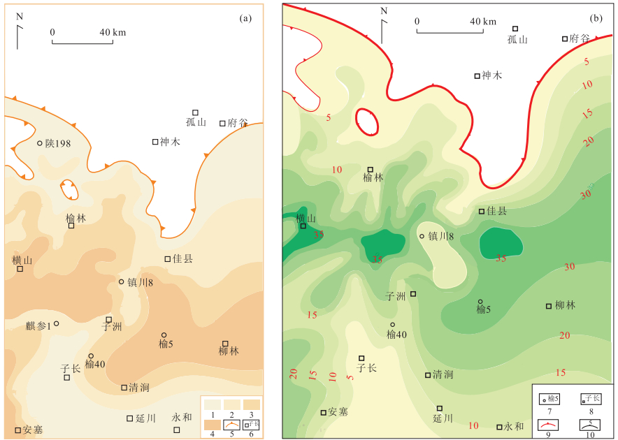
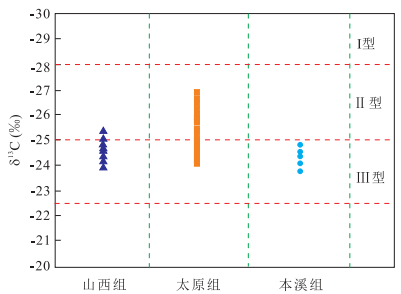
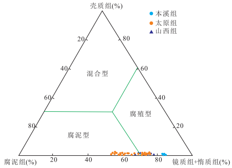
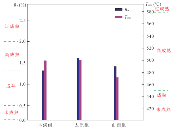
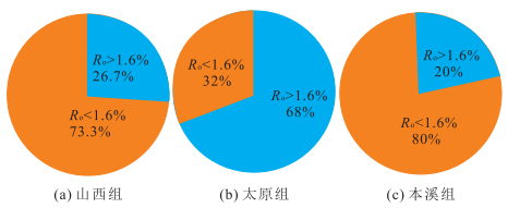
There is little research on whether hydrocarbon generation from limestone in the transitional phase of the Upper Paleozoic in the Ordos basin can be made, and on how much the hydrocarbon can be. Using rock pyrolysis, determination of TOC, carbon isotope of kerogen, organic maceral and Ro experiment, we analyzed the limestone source rocks and characteristics of hydrocarbon generation and expulsion. The results show that:(1)The source rocks from Benxi Formation, Shanxi Formation and Taiyuan Formation is poor, poor-fair, and fair-good respectively according to organic matter abundance. (2)The organic matter type of Benxi Formation, Taiyuan Formation and Shanxi Formation is Ⅲ, Ⅱ2-Ⅲ and Ⅲ mixed with a small quantity of Ⅱ2 respectively. (3) The maturity of source rocks from Benxi Formation is mature-high mature stage, and Taiyuan Formation and Shanxi Formation is high mature stage. According to hydrocarbon expulsion threshold theory, we consider large amount of natural gas generated when Ro is above 1.6%. Considering the particularity of limestone source rocks, maturity and characteristics of hydrocarbon expulsion, we comprehensively consider that the limestone of Taiyuan Formation can be the effective source rocks of natural gas.
There is little research on whether hydrocarbon generation from limestone in the transitional phase of the Upper Paleozoic in the Ordos basin can be made, and on how much the hydrocarbon can be. Using rock pyrolysis, determination of TOC, carbon isotope of kerogen, organic maceral and Ro experiment, we analyzed the limestone source rocks and characteristics of hydrocarbon generation and expulsion. The results show that:(1)The source rocks from Benxi Formation, Shanxi Formation and Taiyuan Formation is poor, poor-fair, and fair-good respectively according to organic matter abundance. (2)The organic matter type of Benxi Formation, Taiyuan Formation and Shanxi Formation is Ⅲ, Ⅱ2-Ⅲ and Ⅲ mixed with a small quantity of Ⅱ2 respectively. (3) The maturity of source rocks from Benxi Formation is mature-high mature stage, and Taiyuan Formation and Shanxi Formation is high mature stage. According to hydrocarbon expulsion threshold theory, we consider large amount of natural gas generated when Ro is above 1.6%. Considering the particularity of limestone source rocks, maturity and characteristics of hydrocarbon expulsion, we comprehensively consider that the limestone of Taiyuan Formation can be the effective source rocks of natural gas.


2018, 43(2): 610-621.
doi: 10.3799/dqkx.2017.604
Abstract:
The space-time difference of hydrocarbon generation and evolution of Carboniferous-Permian coal-measured source rocks in Dongpu depression has always been a dispute. In addition, the quantitative study of hydrocarbon generation history of source rocks remains to be further studied. In this study, the thermal evolution history of source rock was quantitatively evaluated by thermal simulation and basin simulation. It shows that similar gas generation model could be applied to coal-measured mudstone, coal and carbonaceous mudstone with Ro value of 0.5%, 1.2%, 2.2%, and 3.15%. Gas generation phase of source rocks could be divided into five stages. The Carboniferous-Permian source rocks in study area have experienced mature evolution periodically and the whole process of hydrocarbon generation occurring to the source rocks could be divided into three periods, which are the Hercynian-Indosinian epoch, the Early Himalayan epoch and the Late Himalaya epoch. However, the main gas generation periods are distributed from Late Paleogene Shahejie to Dongying period and Neogene Minghuazhen period to the present and thermal evolution of the source rock also entered into the mature-overmature stage meanwhile. The cumulative gas generation intensity was strongest in the Early Himalaya epoch, followed by the Late Himalayan epoch and the Hercynian-Indosinian epoch and the amount of gas generation during the three periods was 9.28%, 62.07%, 28.64% respectively. The main hydrocarbon generation areas are concentrated in the sag zone and in the middle of the central uplift zone, and the gas generation contribution of coal is the largest, accounting for 68% of the total.
The space-time difference of hydrocarbon generation and evolution of Carboniferous-Permian coal-measured source rocks in Dongpu depression has always been a dispute. In addition, the quantitative study of hydrocarbon generation history of source rocks remains to be further studied. In this study, the thermal evolution history of source rock was quantitatively evaluated by thermal simulation and basin simulation. It shows that similar gas generation model could be applied to coal-measured mudstone, coal and carbonaceous mudstone with Ro value of 0.5%, 1.2%, 2.2%, and 3.15%. Gas generation phase of source rocks could be divided into five stages. The Carboniferous-Permian source rocks in study area have experienced mature evolution periodically and the whole process of hydrocarbon generation occurring to the source rocks could be divided into three periods, which are the Hercynian-Indosinian epoch, the Early Himalayan epoch and the Late Himalaya epoch. However, the main gas generation periods are distributed from Late Paleogene Shahejie to Dongying period and Neogene Minghuazhen period to the present and thermal evolution of the source rock also entered into the mature-overmature stage meanwhile. The cumulative gas generation intensity was strongest in the Early Himalaya epoch, followed by the Late Himalayan epoch and the Hercynian-Indosinian epoch and the amount of gas generation during the three periods was 9.28%, 62.07%, 28.64% respectively. The main hydrocarbon generation areas are concentrated in the sag zone and in the middle of the central uplift zone, and the gas generation contribution of coal is the largest, accounting for 68% of the total.


2018, 43(2): 622-634.
doi: 10.3799/dqkx.2017.617
Abstract:
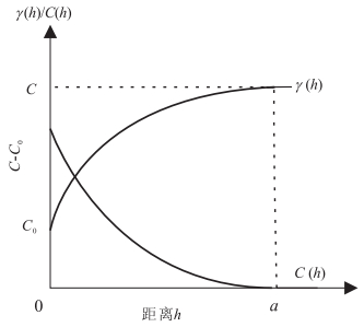
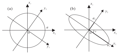
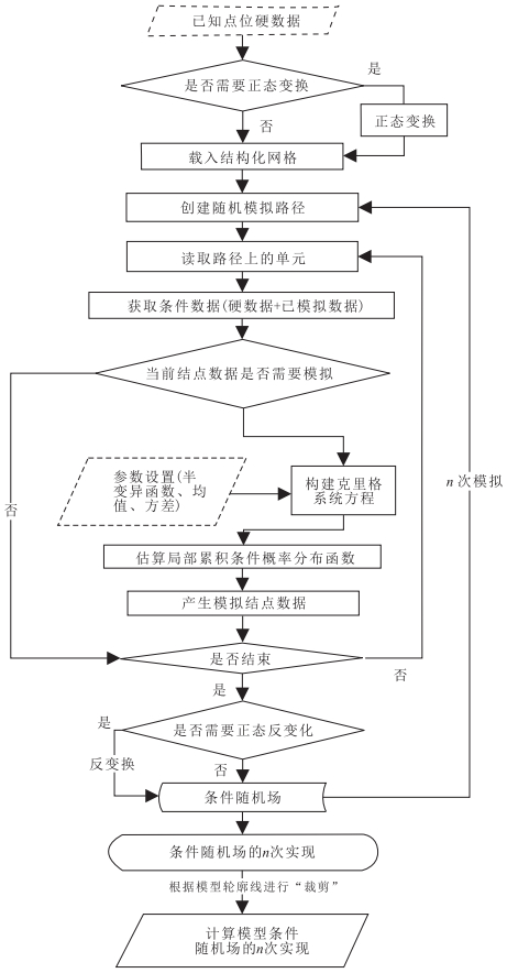
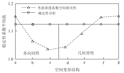
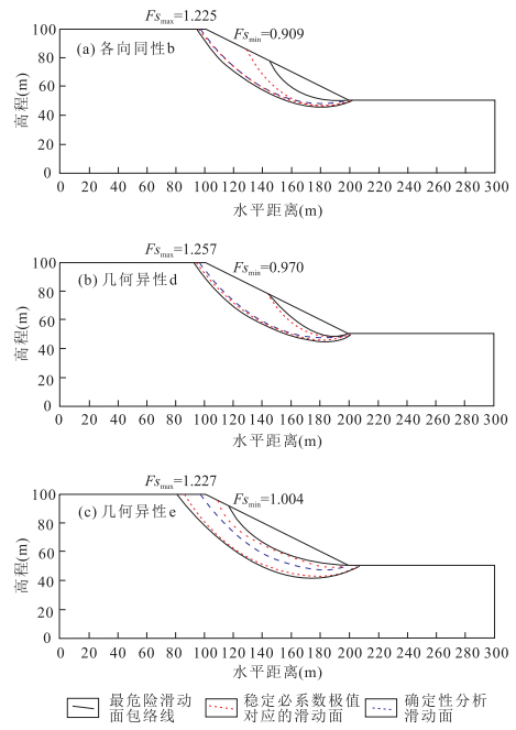
In the previous studies, the spatial variability of geotechnical parameters was simulated based on singe random variable approach (SRV) or random field approach (RF) according to the horizontal or vertical fluctuation range. The spatial variable conditional random field with slant directional characteristics was not involved. Based on the conditional modelling theory and the framework of non-intrusive stochastic finite element method, an original method has been proposed to study the slope seepage and instability characteristics considering spatial variation structure of Ks. This method firstly simulates the conditional random fields of slope parameters taking advantage of sequential Gaussian simulation method (SGS). The Ks random field realizations of a hypothetic slope has been generated in terms of seven different spatial variation structures repeatedly for 200 times. The considered scenarios involved isotropic structure with various ranges (a) and geometric anisotropic structure with various maximum correlation orientations. Seepage and stability analysis was then performed repeatedly according to the assignment random field using finite element method (FEM). According to the FEM analysis results, statistical analysis was then carried out to find the seepage and instability characteristic of the considering seven spatial variation scenarios. The results, on the one hand, show that the proposed method has the priority of reproducing the second-order spatial statistical characteristic of parameters within the study area by the means of changing the variogram parameters to simulate random fields with different spatial variation types, degrees and orientations. The uncertainty of the random field value assignment adjacent to the measurement locations is also much reduced due to the constraints of field measurements. On the other hand, the results show that the spatial variation structure of Ks has a certain impact on pore-water pressure distribution, phreatic line variation bound, factor of safety and most critical slip surface distribution. This research provides methodology support for reservoir slope stability evaluation.
In the previous studies, the spatial variability of geotechnical parameters was simulated based on singe random variable approach (SRV) or random field approach (RF) according to the horizontal or vertical fluctuation range. The spatial variable conditional random field with slant directional characteristics was not involved. Based on the conditional modelling theory and the framework of non-intrusive stochastic finite element method, an original method has been proposed to study the slope seepage and instability characteristics considering spatial variation structure of Ks. This method firstly simulates the conditional random fields of slope parameters taking advantage of sequential Gaussian simulation method (SGS). The Ks random field realizations of a hypothetic slope has been generated in terms of seven different spatial variation structures repeatedly for 200 times. The considered scenarios involved isotropic structure with various ranges (a) and geometric anisotropic structure with various maximum correlation orientations. Seepage and stability analysis was then performed repeatedly according to the assignment random field using finite element method (FEM). According to the FEM analysis results, statistical analysis was then carried out to find the seepage and instability characteristic of the considering seven spatial variation scenarios. The results, on the one hand, show that the proposed method has the priority of reproducing the second-order spatial statistical characteristic of parameters within the study area by the means of changing the variogram parameters to simulate random fields with different spatial variation types, degrees and orientations. The uncertainty of the random field value assignment adjacent to the measurement locations is also much reduced due to the constraints of field measurements. On the other hand, the results show that the spatial variation structure of Ks has a certain impact on pore-water pressure distribution, phreatic line variation bound, factor of safety and most critical slip surface distribution. This research provides methodology support for reservoir slope stability evaluation.