2018 Vol. 43, No. 3
Display Method:
 PDF 281KB
2018, 43(3): 635-654.
doi: 10.3799/dqkx.2018.900
Abstract:
The Jiugongshan gneissic granites exposed in the southeastern margin of the Yangtze Block, and intruded into the Shuangqiaoshan Group of Early Neoproterozoic. Using the methods of cathodoluminescent images analyzing and LA-ICP-MS zircon U-Pb dating, we obtained a magma crystallization age of 830±8 Ma for the Jiugongshan intrusion. Four spots of inherited zircons yield a weighted mean at 873±7 Ma. This age might record the magmatic activity related to the collision between the Yangtze and Cathaysia blocks during the period of Early Neoproterozoic. The Jiugongshan granites are characterized by high SiO2 (71.83%-74.20%), high K2O+Na2O (7.06%-7.90%), low contents of mafic components (∑TiO2+FeOT+MgO=2.64%-4.00%) and high K2O/Na2O ratios (1.25-1.64). They mainly belong to weakly peraluminous granites with A/CNK ratios (1.03-1.27). They share similar distribution patterns of REE and trace elements, i.e., enrichment in LREE and large-ion lithophile elements of K, Rb, Th and U, depletion in Sr, P and high-field-strength elements of Nb, Ta and Ti, and pronounced negative Eu anomalies (Eu/Eu*=0.35-0.47).On the other hand, they have neutral whole-rock εNd(t) values of -1.49 to +5.24 and positive εHf(t) values of 3.5±1.0 to 11.0±1.1 and 5.1±0.9 to 12.9±1.1 respectively for the coeval magmatic zircon and inherited zircon.This indicates a magmatic source with significant components of the juvenile crust. The Jiugongshan intrusion might be formed in the environment of intracontinent rift and generated by partial melting of metamorphic psammitic and volcanic source. Regional comparison shows that the Nd-Hf isotopic composition of the Middle Neoproterozoic granites along the Jiangnan orogeny has the characteristics of decreased gradually from east to west, and suggests that the effect of the Early Neoproterozoic juvenile crust on granitic magmatism decreased from east to west. This might be caused by the decreasing of arc magmatic components from east to west among the orogenetic process.
The Jiugongshan gneissic granites exposed in the southeastern margin of the Yangtze Block, and intruded into the Shuangqiaoshan Group of Early Neoproterozoic. Using the methods of cathodoluminescent images analyzing and LA-ICP-MS zircon U-Pb dating, we obtained a magma crystallization age of 830±8 Ma for the Jiugongshan intrusion. Four spots of inherited zircons yield a weighted mean at 873±7 Ma. This age might record the magmatic activity related to the collision between the Yangtze and Cathaysia blocks during the period of Early Neoproterozoic. The Jiugongshan granites are characterized by high SiO2 (71.83%-74.20%), high K2O+Na2O (7.06%-7.90%), low contents of mafic components (∑TiO2+FeOT+MgO=2.64%-4.00%) and high K2O/Na2O ratios (1.25-1.64). They mainly belong to weakly peraluminous granites with A/CNK ratios (1.03-1.27). They share similar distribution patterns of REE and trace elements, i.e., enrichment in LREE and large-ion lithophile elements of K, Rb, Th and U, depletion in Sr, P and high-field-strength elements of Nb, Ta and Ti, and pronounced negative Eu anomalies (Eu/Eu*=0.35-0.47).On the other hand, they have neutral whole-rock εNd(t) values of -1.49 to +5.24 and positive εHf(t) values of 3.5±1.0 to 11.0±1.1 and 5.1±0.9 to 12.9±1.1 respectively for the coeval magmatic zircon and inherited zircon.This indicates a magmatic source with significant components of the juvenile crust. The Jiugongshan intrusion might be formed in the environment of intracontinent rift and generated by partial melting of metamorphic psammitic and volcanic source. Regional comparison shows that the Nd-Hf isotopic composition of the Middle Neoproterozoic granites along the Jiangnan orogeny has the characteristics of decreased gradually from east to west, and suggests that the effect of the Early Neoproterozoic juvenile crust on granitic magmatism decreased from east to west. This might be caused by the decreasing of arc magmatic components from east to west among the orogenetic process.


2018, 43(3): 655-671.
doi: 10.3799/dqkx.2018.901
Abstract:
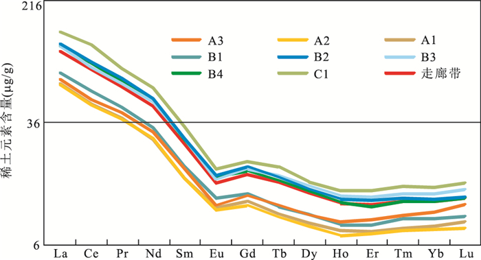
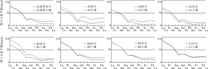
In order to study the regional geochemical composition and lateral spatial variation of the geochemical belt in the North China Craton, rock and regolith samples along a transect across the Xingmeng Orogenic Belt-North China Craton were collected and 14 rare earth element (REE) concentrations were determined. Data of statistical analyses for regolith samples were based on tectonic units, geographical landscape, soil types and rainfall units, and for rock samples were based on tectonic units, rock types, and geologic age units. An average value was calculated from each 1:50 000 map sheet. The spatial distribution of REE concentrations is plotted in figures. The results show that:(1) REEs are depleted in Inner Mongolia semi-arid grassland soils due to less clay minerals in the soils, whereas REEs are enriched in the alluvial plain soils of the northern Jiangsu corresponding to the maximum rainfall zone. (2) In the transect from Honger to Zhangjiakou, REE ratio of soil to rock mostly is less than 1, indicating that the REE is leached in soils or diluted by windblown sand; in the transect from Zhangqiu to Lianyungang, the ratio is greater than 1, indicating that the soil REE are enriched in soils. (3)The REE characteristics of the Inner Mongolia block, which belong to the North China Craton, are more similar to those of the Xingmeng Orogenic Belt, affected by the semi-arid sandy soil of Inner Mongolia; The spatial distribution of LREE and HREE with depletion or enrichment in different tectonic units indicates that geochemical properties of REE affecting on the fractionation of REE in the process of soil formation.
In order to study the regional geochemical composition and lateral spatial variation of the geochemical belt in the North China Craton, rock and regolith samples along a transect across the Xingmeng Orogenic Belt-North China Craton were collected and 14 rare earth element (REE) concentrations were determined. Data of statistical analyses for regolith samples were based on tectonic units, geographical landscape, soil types and rainfall units, and for rock samples were based on tectonic units, rock types, and geologic age units. An average value was calculated from each 1:50 000 map sheet. The spatial distribution of REE concentrations is plotted in figures. The results show that:(1) REEs are depleted in Inner Mongolia semi-arid grassland soils due to less clay minerals in the soils, whereas REEs are enriched in the alluvial plain soils of the northern Jiangsu corresponding to the maximum rainfall zone. (2) In the transect from Honger to Zhangjiakou, REE ratio of soil to rock mostly is less than 1, indicating that the REE is leached in soils or diluted by windblown sand; in the transect from Zhangqiu to Lianyungang, the ratio is greater than 1, indicating that the soil REE are enriched in soils. (3)The REE characteristics of the Inner Mongolia block, which belong to the North China Craton, are more similar to those of the Xingmeng Orogenic Belt, affected by the semi-arid sandy soil of Inner Mongolia; The spatial distribution of LREE and HREE with depletion or enrichment in different tectonic units indicates that geochemical properties of REE affecting on the fractionation of REE in the process of soil formation.


2018, 43(3): 672-695.
doi: 10.3799/dqkx.2017.510
Abstract:
The study of magmatism can reveal the structure and tectonic evolution of the orogeny. In this paper, we present zircon LA-MC-ICP-MS U-Pb dating, Hf-Sr-Nd isotopic compositions and whole rock geochemical data of the Carboniferous Arc intrusive rocks from Yuejin region of Xilinhot, central part of the Xingmeng Orogenic Belt. The rock suit consists of three major rock types, i.e., granodiorite, tonalite and quartz-diorite, with zircon U-Pb ages ranging from 310±1 to 330±1 Ma. Geochemically, these rocks show moderate SiO2, high and variable Na2O, Al2O3, and CaO contents, but low K2O, FeOt and MgO contents.The Na2O/K2O ratios are all higher than 1(1.05-2.68, average of 1.95), while these rocks are of Calc-Alkaline series. The A/CNK ratios range from 0.86 to 1.17, indicating most of samples are meta-to weak per-aluminous series. The Mg# are moderately high, from 47.5-55.8. The trace elemental data of these rocks display enrichment of LILEs, such as Rb, Ba, Th, U, K, but depletion of HFSE, i.e., Nb, Ta, P and Ti. The total REE contents are low (3.62×10⁻⁶-172.33×10⁻⁶, average of 118.33×10⁻⁶) with moderate fractionation between LREE and HREE ((La/Yb)N range from 2.48-9.44), while weak negative Eu abnormity are observed(δEu range from 0.70 to 1.04). The in-situ zircon Hf isotopic analysis show depleted compositions with 176Hf/177Hf ratios varying from 0.282 723 to 0.282 863, εHf(t) values from +2 to +9.9 and Hf two stage model ages(TDMC) from 829 to 1 536 Ma(concentrating from 900 to 1 200 Ma). The whole rock Sr-Nd isotopic analysis of (87Sr/86Sr)i range from 0.703 7 to 0.704 8, (143Nd/144Nd)i range from 0.512 320 to 0.512 401, with positive εNd(t) (+2.1 to +3.6), indicating depleted source, and the Nd two stage model ages(TDM2) are of Neoproterozoic(793-918 Ma). The rock suit, whole rock geochemistry, Hf-Sr-Nd isotopic characteristics indicate that Yuejin Carboniferous intrusive rocks were formed in active continental margin, by the partial melting of basic juvenile crust (formed in Late Mesoproterozoic to Early Neoproterozoic) triggered by subduction fluid and arc basic magma. This tectonic setting demonstrates that there was still subduction in Carboniferous in Xingmeng orogeny and the ocean was not closed.
The study of magmatism can reveal the structure and tectonic evolution of the orogeny. In this paper, we present zircon LA-MC-ICP-MS U-Pb dating, Hf-Sr-Nd isotopic compositions and whole rock geochemical data of the Carboniferous Arc intrusive rocks from Yuejin region of Xilinhot, central part of the Xingmeng Orogenic Belt. The rock suit consists of three major rock types, i.e., granodiorite, tonalite and quartz-diorite, with zircon U-Pb ages ranging from 310±1 to 330±1 Ma. Geochemically, these rocks show moderate SiO2, high and variable Na2O, Al2O3, and CaO contents, but low K2O, FeOt and MgO contents.The Na2O/K2O ratios are all higher than 1(1.05-2.68, average of 1.95), while these rocks are of Calc-Alkaline series. The A/CNK ratios range from 0.86 to 1.17, indicating most of samples are meta-to weak per-aluminous series. The Mg# are moderately high, from 47.5-55.8. The trace elemental data of these rocks display enrichment of LILEs, such as Rb, Ba, Th, U, K, but depletion of HFSE, i.e., Nb, Ta, P and Ti. The total REE contents are low (3.62×10⁻⁶-172.33×10⁻⁶, average of 118.33×10⁻⁶) with moderate fractionation between LREE and HREE ((La/Yb)N range from 2.48-9.44), while weak negative Eu abnormity are observed(δEu range from 0.70 to 1.04). The in-situ zircon Hf isotopic analysis show depleted compositions with 176Hf/177Hf ratios varying from 0.282 723 to 0.282 863, εHf(t) values from +2 to +9.9 and Hf two stage model ages(TDMC) from 829 to 1 536 Ma(concentrating from 900 to 1 200 Ma). The whole rock Sr-Nd isotopic analysis of (87Sr/86Sr)i range from 0.703 7 to 0.704 8, (143Nd/144Nd)i range from 0.512 320 to 0.512 401, with positive εNd(t) (+2.1 to +3.6), indicating depleted source, and the Nd two stage model ages(TDM2) are of Neoproterozoic(793-918 Ma). The rock suit, whole rock geochemistry, Hf-Sr-Nd isotopic characteristics indicate that Yuejin Carboniferous intrusive rocks were formed in active continental margin, by the partial melting of basic juvenile crust (formed in Late Mesoproterozoic to Early Neoproterozoic) triggered by subduction fluid and arc basic magma. This tectonic setting demonstrates that there was still subduction in Carboniferous in Xingmeng orogeny and the ocean was not closed.


2018, 43(3): 696-715.
doi: 10.3799/dqkx.2018.902
Abstract:
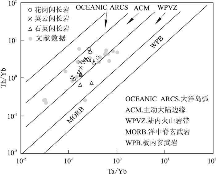
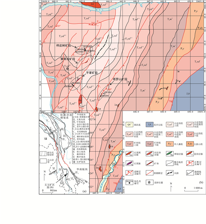
Wenyu copper (silver) ore, located in Yun county-Jinghong volcanic arc, is important deposit related to volcanism. It is important to understand its geological background since it is basic for discussing mineralization of Wenyu ore area. This paper reports petrology, geochemistry and zircon LA-ICP-MS chronology of volcanic rocks from Xiaodingxi Formation in the mining area.Results show that they are composed of basaltic rocks and a small amount of acidic rocks, with SiO2 ranging from 47.94%-54.02% and 76.92%-84.16%, respectively, exhibiting the features of bimodal volcanic rocks. Zircon U-Pb age of rhyolite is 238.4±2.4 Ma(MSWD=1.4), showing that volcanic rocks in Xiaodingxi Formation formed at Middle Triassic, rather than Late Triassic. The basaltic volcanic rocks are characterized by low Mg and high Al, belonging to shoshonite-high K calc-alkaline-calc-alkaline series, with strong negative Sr, Ti, Nb and Ta anomalies, weak negative Eu anomalies, and lower (La/Yb)N ratio and Mg#, Cr and Ni contents. Acidic volcanic rocks belong to peraluminous high K calc-alkaline series, with strong negative Sr, Ti, P, Nb, Ta, Ba and Eu anomalies. Nb/Ta and Th/Ce ratios are relatively consistent with those of continental crust, displaying characteristics of high Th and low Mg#, which suggests that it formed in an extension setting during a margin of arc (continent)-continent collision in the early Middle Triassic, which is a result of oceanic crust subduction slab break-off. In combination with regional volcanism and metallogenesis research data, it is concluded that multi-stage volcanism in the collision extension environment occurred many times during the Middle Triassic, indicating a good prospect of volcanism mineralization.
Wenyu copper (silver) ore, located in Yun county-Jinghong volcanic arc, is important deposit related to volcanism. It is important to understand its geological background since it is basic for discussing mineralization of Wenyu ore area. This paper reports petrology, geochemistry and zircon LA-ICP-MS chronology of volcanic rocks from Xiaodingxi Formation in the mining area.Results show that they are composed of basaltic rocks and a small amount of acidic rocks, with SiO2 ranging from 47.94%-54.02% and 76.92%-84.16%, respectively, exhibiting the features of bimodal volcanic rocks. Zircon U-Pb age of rhyolite is 238.4±2.4 Ma(MSWD=1.4), showing that volcanic rocks in Xiaodingxi Formation formed at Middle Triassic, rather than Late Triassic. The basaltic volcanic rocks are characterized by low Mg and high Al, belonging to shoshonite-high K calc-alkaline-calc-alkaline series, with strong negative Sr, Ti, Nb and Ta anomalies, weak negative Eu anomalies, and lower (La/Yb)N ratio and Mg#, Cr and Ni contents. Acidic volcanic rocks belong to peraluminous high K calc-alkaline series, with strong negative Sr, Ti, P, Nb, Ta, Ba and Eu anomalies. Nb/Ta and Th/Ce ratios are relatively consistent with those of continental crust, displaying characteristics of high Th and low Mg#, which suggests that it formed in an extension setting during a margin of arc (continent)-continent collision in the early Middle Triassic, which is a result of oceanic crust subduction slab break-off. In combination with regional volcanism and metallogenesis research data, it is concluded that multi-stage volcanism in the collision extension environment occurred many times during the Middle Triassic, indicating a good prospect of volcanism mineralization.


2018, 43(3): 716-732.
doi: 10.3799/dqkx.2018.903
Abstract:
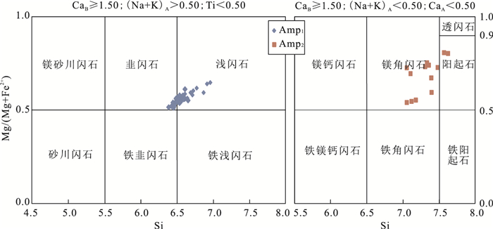
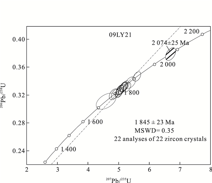
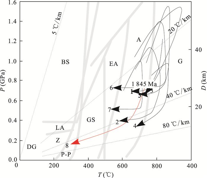
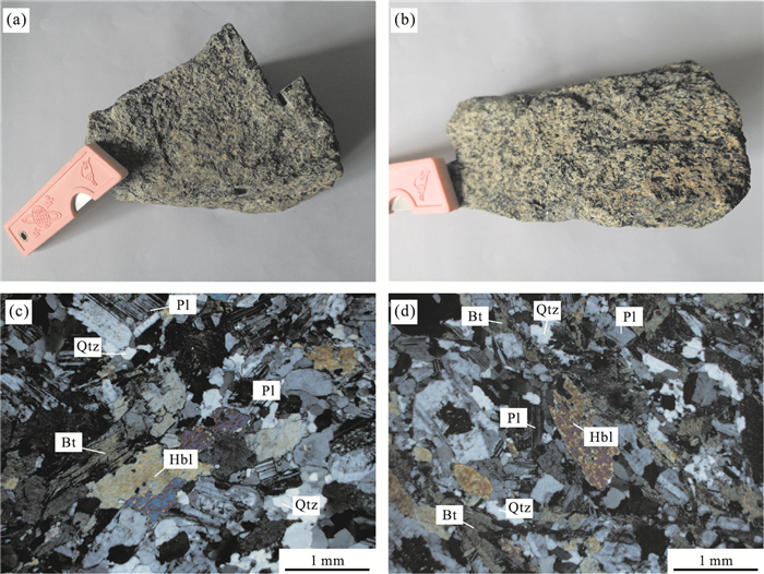
Jiaobei terrane lies in the southern segment of the Paleoproterozoic Jiao-Liao-Ji belt, eastern block of the North China craton. There is a set of amphibolite closely related to the high-pressure mafic granulite in Jingshan complex of Jiaobei terrane, which is an important component of the Precambrian metamorphic basement. Our petrological and mineralogical study shows that amphibolite records three stages of metamorphism. The peak stage (M1) shows a mineral assemblage Amp1+Pl +Ttn. The temperature calculated by pseudosection modeling and estimated pressure conditions are T=660-715 ℃, P=0.65-0.71 GPa. The mineral assemblage at post-peak stage (M2) is Amp2+Ep+Pl+Chl+Ab, suggesting temperature and pressure conditions 537-630 ℃/0.41-0.58 GPa. The mineral assemblage at retrograde stage (M3) is Ab+Prh+Chl+Cal.Prehnite and calcite veins indicate that the amphibolite underwent a prehnite-pumpellyite facies metamorphism with P-T conditions < 400 ℃/0.35 GPa.LA-ICP-MS U-Pb geochronology combined with cathodoluminescence (CL) imaging of 21 zircons are all characterized by relatively low Th/U ratios (0.06-0.43), low luminescence and weakly oscillatory zoning. The morphological and internal structure features of zircons suggest that their growths were associated with partial melting, and they yielded 206Pb/238U weighted mean ages of 1 845±23 Ma (MSWD=0.35). After formation of the mafic rock, it may have experienced granulite facies metamorphism, and then recorded the anataxis event during collisional convergence of the Jiao-Liao-Ji orogenic belt at~1.85 Ga. The investigated amphibolite recorded amphibolite facies metamorphism, and subsquently two episodes of retrogressive metamorphism during the lift of the belt.
Jiaobei terrane lies in the southern segment of the Paleoproterozoic Jiao-Liao-Ji belt, eastern block of the North China craton. There is a set of amphibolite closely related to the high-pressure mafic granulite in Jingshan complex of Jiaobei terrane, which is an important component of the Precambrian metamorphic basement. Our petrological and mineralogical study shows that amphibolite records three stages of metamorphism. The peak stage (M1) shows a mineral assemblage Amp1+Pl +Ttn. The temperature calculated by pseudosection modeling and estimated pressure conditions are T=660-715 ℃, P=0.65-0.71 GPa. The mineral assemblage at post-peak stage (M2) is Amp2+Ep+Pl+Chl+Ab, suggesting temperature and pressure conditions 537-630 ℃/0.41-0.58 GPa. The mineral assemblage at retrograde stage (M3) is Ab+Prh+Chl+Cal.Prehnite and calcite veins indicate that the amphibolite underwent a prehnite-pumpellyite facies metamorphism with P-T conditions < 400 ℃/0.35 GPa.LA-ICP-MS U-Pb geochronology combined with cathodoluminescence (CL) imaging of 21 zircons are all characterized by relatively low Th/U ratios (0.06-0.43), low luminescence and weakly oscillatory zoning. The morphological and internal structure features of zircons suggest that their growths were associated with partial melting, and they yielded 206Pb/238U weighted mean ages of 1 845±23 Ma (MSWD=0.35). After formation of the mafic rock, it may have experienced granulite facies metamorphism, and then recorded the anataxis event during collisional convergence of the Jiao-Liao-Ji orogenic belt at~1.85 Ga. The investigated amphibolite recorded amphibolite facies metamorphism, and subsquently two episodes of retrogressive metamorphism during the lift of the belt.


2018, 43(3): 733-752.
doi: 10.3799/dqkx.2018.904
Abstract:
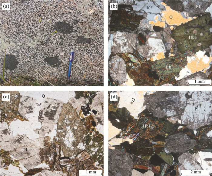
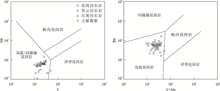
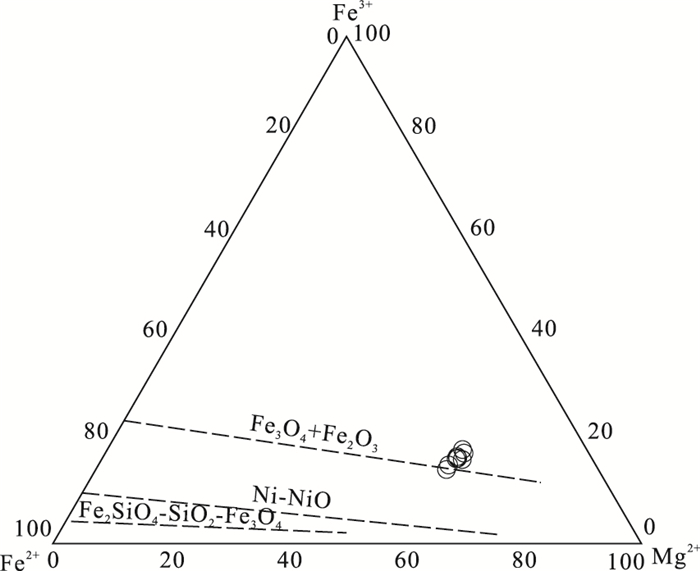
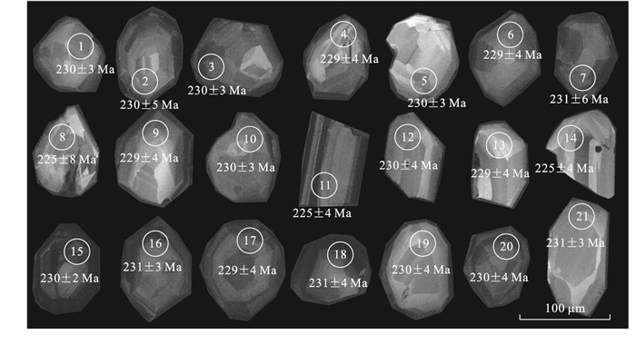
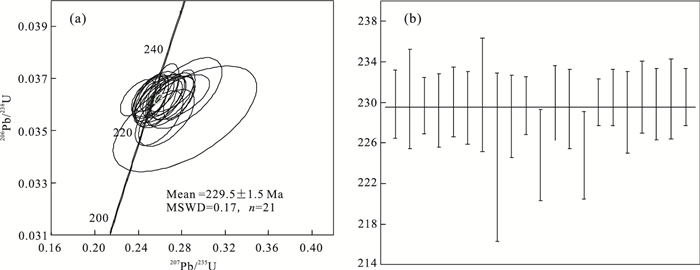
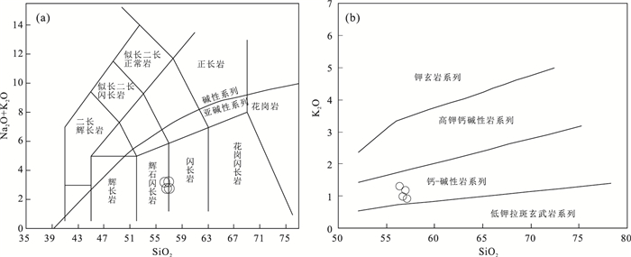
This paper presents petrography, electron microprobe results, zircon U-Pb dating and geochemistry of diorites at Chayong, Yushu, Qinghai Province, with the aim of constraining its petrogenesis and geodynamic significance. The dating results indicate that the diorite formed in the Late Triassic (230±2 Ma). Electronic Probe analysis results show that plagioclase has a band structure with bytownite and calciclase in the centre, andesine and labradorite on the edge. Biotite belongs to magnesia biotite, which crystallized at temperature of 647-688 ℃, at depth of 14.2-15.5 km.Hornblende belongs to calcic amphibole and has the characteristics of crust-mantle mixing origin of the magma.The diorites contain high SiO2, MgO, Mg# values, Cr and Ni, enriched in large ion lithophile elements (LILEs) and light rare earth elements(LREEs), depleted in the high field strength elements (HFSE), which is similar with high-Mg diorite. The εHf(t) values of zircons from the diorites vary from -10.4 to -10.3 and from -6.4 to -4.0, and their Hf one-stage model ages vary from 1 021 to 1 311 Ma. They are likely formed from mantle peridotites by reacting with Si-rich melts released from subducted oceanic slab. Combined with regional tectonic evolution, it is suggested that the diorites might have been resulted from the subduction of Jinshajiang Ocean in the Late Triassic.
This paper presents petrography, electron microprobe results, zircon U-Pb dating and geochemistry of diorites at Chayong, Yushu, Qinghai Province, with the aim of constraining its petrogenesis and geodynamic significance. The dating results indicate that the diorite formed in the Late Triassic (230±2 Ma). Electronic Probe analysis results show that plagioclase has a band structure with bytownite and calciclase in the centre, andesine and labradorite on the edge. Biotite belongs to magnesia biotite, which crystallized at temperature of 647-688 ℃, at depth of 14.2-15.5 km.Hornblende belongs to calcic amphibole and has the characteristics of crust-mantle mixing origin of the magma.The diorites contain high SiO2, MgO, Mg# values, Cr and Ni, enriched in large ion lithophile elements (LILEs) and light rare earth elements(LREEs), depleted in the high field strength elements (HFSE), which is similar with high-Mg diorite. The εHf(t) values of zircons from the diorites vary from -10.4 to -10.3 and from -6.4 to -4.0, and their Hf one-stage model ages vary from 1 021 to 1 311 Ma. They are likely formed from mantle peridotites by reacting with Si-rich melts released from subducted oceanic slab. Combined with regional tectonic evolution, it is suggested that the diorites might have been resulted from the subduction of Jinshajiang Ocean in the Late Triassic.


2018, 43(3): 753-769.
doi: 10.3799/dqkx.2018.905
Abstract:
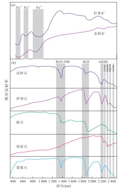
Soils from Earth's surface record critical evolution information on climate, environment and human since the Quaternary. Soil is regarded as one of the most important carrier for studying the past geological history. The soil properties, such as ion transformation, grain size distribution, mineral content and composition, are closely related to the coeval climate and environment variation. Some properties are extracted as weathering proxies, which are widely used to reconstruct the past climate history. In this study we focused the climatic significance, research methods and case studies of the authigenic mineral proxies-clay minerals and Fe-oxide minerals, and review their advantages and limitations in reflecting weathering degrees and climate conditions. Clay minerals and Fe-oxide minerals can be used as independent weathering and climate proxies. However, the applicability is conditioned by geological background, provenance, climate type, etc.. Besides, a multi-proxy method is preferred in regional weathering and climate reconstruction.
Soils from Earth's surface record critical evolution information on climate, environment and human since the Quaternary. Soil is regarded as one of the most important carrier for studying the past geological history. The soil properties, such as ion transformation, grain size distribution, mineral content and composition, are closely related to the coeval climate and environment variation. Some properties are extracted as weathering proxies, which are widely used to reconstruct the past climate history. In this study we focused the climatic significance, research methods and case studies of the authigenic mineral proxies-clay minerals and Fe-oxide minerals, and review their advantages and limitations in reflecting weathering degrees and climate conditions. Clay minerals and Fe-oxide minerals can be used as independent weathering and climate proxies. However, the applicability is conditioned by geological background, provenance, climate type, etc.. Besides, a multi-proxy method is preferred in regional weathering and climate reconstruction.


2018, 43(3): 770-785.
doi: 10.3799/dqkx.2018.906
Abstract:
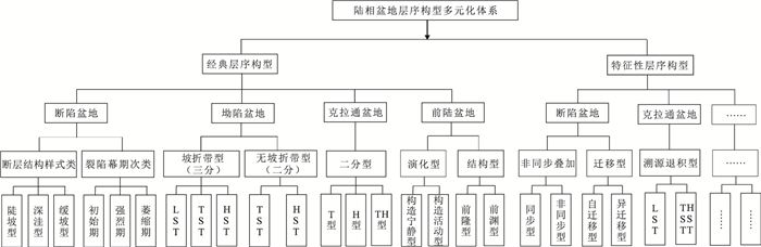
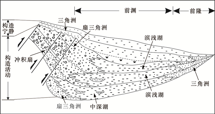
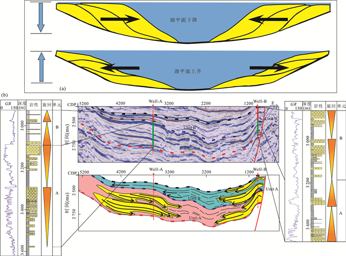
Unlike sequence stratigraphic configuration of the established, relatively stable tectono-sedimentary regimes of the marine basins, the sequence stratigraphic configurations of continental (lacustrine) basins are variable. The varieties of sequence stratigraphic configuration systems of continental basins have been established on the basis of the unique geological characteristics of continental basins (e.g.finite sizes of the receiving area, closed basin setting, multiple basin types, complex controlling factors, multiple sediment source points and supplies, paleo-geomorphological variations, etc.) in this study, which are descibed as "complex continental basin systems create multiple sequence stratigraphic architectures and patterns under the combined influence of multiple controlling factors". The varieties of sequence stratigraphic configuration systems comprise both the classic and some special models.Multiple classic models are summarized for continental rifted, depression, foreland, and cratonic basins. There are also some established special sequence stratigraphic models documented, including non-synchronous sequence stacking models and switched sequence stratigraphic stacking models for continental rifted basins, and retrogradational sequence stratigraphic models for intra-cratonic basins. The newly proposed "variable sequence stratigraphic configuration systems" display complex sedimentary dynamics of continental basins and provide an effective scheme to describe sequence stratigraphic patterns developed in continental basins. This study may serve as an effective general reference for full characterization of complex sequence stratigraphic configurations in continental basins and enrich the sequence stratigraphic theory of continental basins.
Unlike sequence stratigraphic configuration of the established, relatively stable tectono-sedimentary regimes of the marine basins, the sequence stratigraphic configurations of continental (lacustrine) basins are variable. The varieties of sequence stratigraphic configuration systems of continental basins have been established on the basis of the unique geological characteristics of continental basins (e.g.finite sizes of the receiving area, closed basin setting, multiple basin types, complex controlling factors, multiple sediment source points and supplies, paleo-geomorphological variations, etc.) in this study, which are descibed as "complex continental basin systems create multiple sequence stratigraphic architectures and patterns under the combined influence of multiple controlling factors". The varieties of sequence stratigraphic configuration systems comprise both the classic and some special models.Multiple classic models are summarized for continental rifted, depression, foreland, and cratonic basins. There are also some established special sequence stratigraphic models documented, including non-synchronous sequence stacking models and switched sequence stratigraphic stacking models for continental rifted basins, and retrogradational sequence stratigraphic models for intra-cratonic basins. The newly proposed "variable sequence stratigraphic configuration systems" display complex sedimentary dynamics of continental basins and provide an effective scheme to describe sequence stratigraphic patterns developed in continental basins. This study may serve as an effective general reference for full characterization of complex sequence stratigraphic configurations in continental basins and enrich the sequence stratigraphic theory of continental basins.


2018, 43(3): 786-801.
doi: 10.3799/dqkx.2017.501
Abstract:
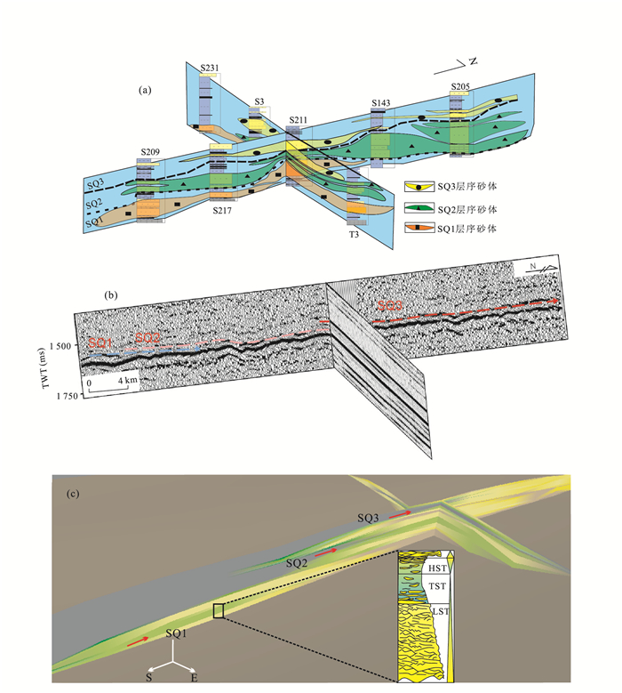
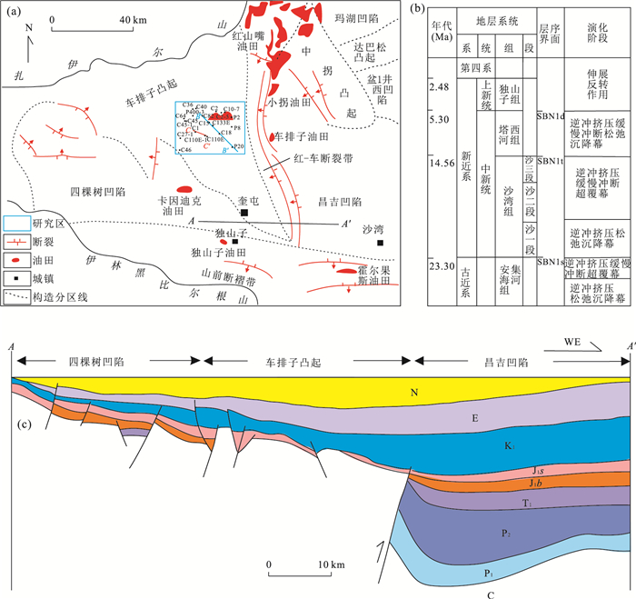
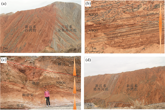
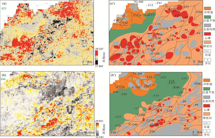
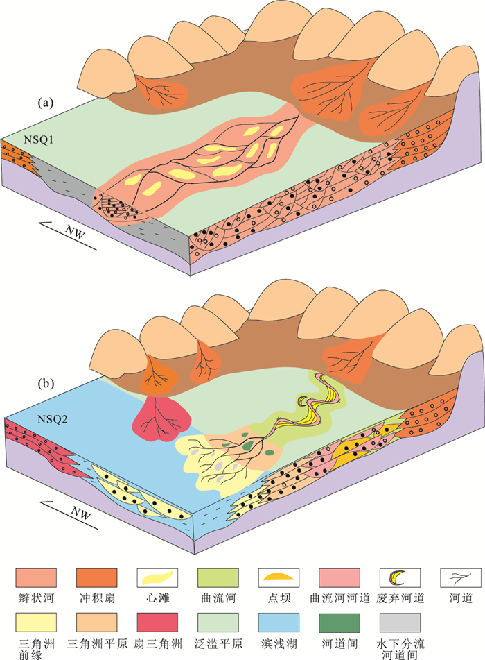
The Neogene Shawan Formation from the Chepaizi uplift of the Junggar basin, has multiple sources and complex depositional systems. It has long been debated about the depositional systems due to limited well and core data. Besides, it is hard to depict the spatial and temporal evolution. The depositional system is the key to depict the single sandbody and its architecture, which has a profound meaning for hydrocarbon exploration. Based on 3D seismic data, core data and well logs, combined with the seismic geomorphology approach, the depositional systems and evolution history of the Neogene Shawan Formation in the Chepaizi uplift of the Junggar Basin were studied in great detail. A sequence stratigraphy framework was established. And, two third-order sequences, namely, sequences NSQ1 and NSQ2 from base to top, and four forth-order sequences were identified from the Shawan Formation. Six depositional systems, namely, braided river, alluvial fan, meandering river, meandering river delta, fan delta and shallow lacustrine systems, were identified. Then, two sedimentary models, namely, alluvial fan-braided river systems and fan delta-meandering river delta systems, were built in the study area. Finally, the prediction model of sand bodies was constructed. There has showed significant indication of oil and gas in the sand bodies of braided rivers, mid-channel bars, point bars, and alluvial fan. So, they are the primary reservoirs in study area. It is proved that seismic sedimentary is a useful approach applied in multiple sources, complex sedimentary systems in gentle slope of lacustrine basin when core data and well data are limited.
The Neogene Shawan Formation from the Chepaizi uplift of the Junggar basin, has multiple sources and complex depositional systems. It has long been debated about the depositional systems due to limited well and core data. Besides, it is hard to depict the spatial and temporal evolution. The depositional system is the key to depict the single sandbody and its architecture, which has a profound meaning for hydrocarbon exploration. Based on 3D seismic data, core data and well logs, combined with the seismic geomorphology approach, the depositional systems and evolution history of the Neogene Shawan Formation in the Chepaizi uplift of the Junggar Basin were studied in great detail. A sequence stratigraphy framework was established. And, two third-order sequences, namely, sequences NSQ1 and NSQ2 from base to top, and four forth-order sequences were identified from the Shawan Formation. Six depositional systems, namely, braided river, alluvial fan, meandering river, meandering river delta, fan delta and shallow lacustrine systems, were identified. Then, two sedimentary models, namely, alluvial fan-braided river systems and fan delta-meandering river delta systems, were built in the study area. Finally, the prediction model of sand bodies was constructed. There has showed significant indication of oil and gas in the sand bodies of braided rivers, mid-channel bars, point bars, and alluvial fan. So, they are the primary reservoirs in study area. It is proved that seismic sedimentary is a useful approach applied in multiple sources, complex sedimentary systems in gentle slope of lacustrine basin when core data and well data are limited.


2018, 43(3): 802-811.
doi: 10.3799/dqkx.2017.508
Abstract:
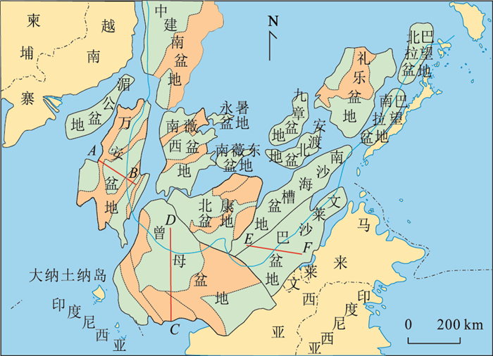
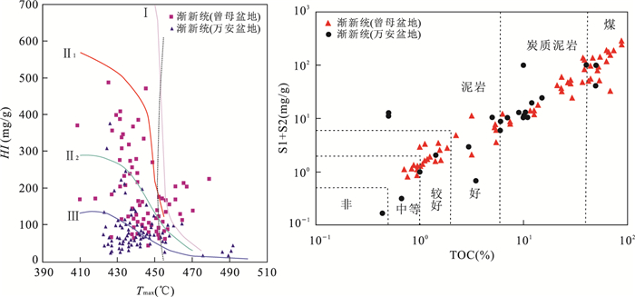
Many studies have been carried out on the hydrocarbon geologic conditions of Wan'an, Zengmu and Brunei-Sabah basins. However, there are few studies on the difference of hydrocarbon geologic conditions among basins. Based on a lot of previous research results, drilling, seismic data and oil and gas testing data were comprehensively used to analyse the main difference of hydrocarbon geology in the Wan'an, Zengmu and Brunei-Sabah basins in southern South China Sea. The study shows that the Cenozoic of the three basins all developed two tectonic stages, mainly developing marine-land transitional facies and marine depositional environment. Three periods (Oligocene, Miocene and Pliocene) developed two types of source rocks, i.e. the coal measures and terrigenous marine facies, the period of major source rock is gradually new from west to east. Developed two types of reservoirs, i.e. clastic sandstone and carbonate rock, reservoirs distribution may be characterized by near shore sand and distant shore reef, the reservoirs period is gradually new from west to east. There are two combination of source rock and reservoris, i.e. the distant shore self-generation and self-reservoiring and the near shore lower-generation and upper-reservoiring.
Many studies have been carried out on the hydrocarbon geologic conditions of Wan'an, Zengmu and Brunei-Sabah basins. However, there are few studies on the difference of hydrocarbon geologic conditions among basins. Based on a lot of previous research results, drilling, seismic data and oil and gas testing data were comprehensively used to analyse the main difference of hydrocarbon geology in the Wan'an, Zengmu and Brunei-Sabah basins in southern South China Sea. The study shows that the Cenozoic of the three basins all developed two tectonic stages, mainly developing marine-land transitional facies and marine depositional environment. Three periods (Oligocene, Miocene and Pliocene) developed two types of source rocks, i.e. the coal measures and terrigenous marine facies, the period of major source rock is gradually new from west to east. Developed two types of reservoirs, i.e. clastic sandstone and carbonate rock, reservoirs distribution may be characterized by near shore sand and distant shore reef, the reservoirs period is gradually new from west to east. There are two combination of source rock and reservoris, i.e. the distant shore self-generation and self-reservoiring and the near shore lower-generation and upper-reservoiring.


2018, 43(3): 812-826.
doi: 10.3799/dqkx.2017.511
Abstract:
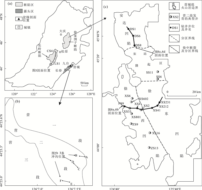
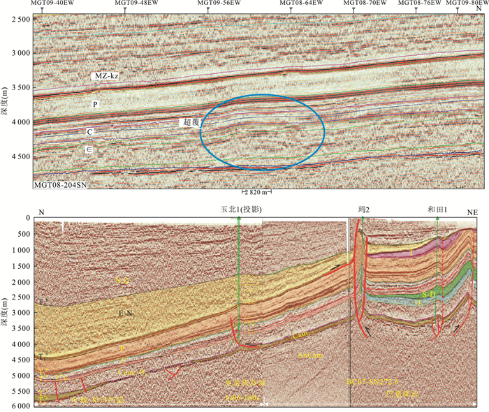
Diachronous and inversion phenomenon often occurs in volcano strata, coupled with the lack of fossil data in the volcanic rock, it is difficult to determine the volcano stratigraphic sequence.The stratigraphic sequence of Yingcheng Formation is the basic and key to volcanic oil and gas exploration in Songliao basin. The sedimentary layers (the Second Member, Yingcheng Formation) between lower and upper volcanic of Yingcheng Formation play an important role in the division of stratigraphic sequence as a marker bed. Based on cross section, core sections/cuttings, well-logs of boreholes, 3D seismic, and isotopic age data, we compare the cross section at the basin margin and boreholes in Xujiaweizi graben to analysis whether the Second Member, Yingcheng Formation is widespread in Songliao basin and summary the time interval, lithology and sequence features, plane distribution, and geophysical characteristics of the Second Member, Yingcheng Formation which can be used to divide and correlate volcano strata accurately as a marker bed. Through stratigraphic correlation we consider that the Second Member, Yingcheng Formation is indeed widespread in Songliao basin, and its age can be well constrained to Albian with a chronology age ranging from 110 Ma to 108 Ma. There was enough time to form the sedimentary bed during 2-3 Ma volcanic eruption interval. The main lithology features of the Second Member, Yingcheng Formation is rich in tuffaceous and contain coal seams occasionally, and the complete lithologic sequence from the bottom showing "coarse-fine-coarse" variation. There are different sedimentary centers of the Second Member, Yingcheng Formation. One type is mainly influenced by the thermal subsidence after the volcanic eruption, and another type is mainly controlled by the palaeogeomorphology. Two types of strata have different geophysical response characteristics due to their different origin. The stratigraphic sequence of Yingcheng Formation can be divided to three member when use the sedimentary layers (the Second Member, Yingcheng Formation) as a marker bed, the First Member and the Third Member are volcanic, and the former Forth Member should be divided to two parts, the lower part of fine sand-mud layers belong to the Second Member, and the upper part of conglomerate layers should be a part of Delouku Formation. This method can be used as a reference for stratigraphic sequence division and correlation in other volcanic areas.
Diachronous and inversion phenomenon often occurs in volcano strata, coupled with the lack of fossil data in the volcanic rock, it is difficult to determine the volcano stratigraphic sequence.The stratigraphic sequence of Yingcheng Formation is the basic and key to volcanic oil and gas exploration in Songliao basin. The sedimentary layers (the Second Member, Yingcheng Formation) between lower and upper volcanic of Yingcheng Formation play an important role in the division of stratigraphic sequence as a marker bed. Based on cross section, core sections/cuttings, well-logs of boreholes, 3D seismic, and isotopic age data, we compare the cross section at the basin margin and boreholes in Xujiaweizi graben to analysis whether the Second Member, Yingcheng Formation is widespread in Songliao basin and summary the time interval, lithology and sequence features, plane distribution, and geophysical characteristics of the Second Member, Yingcheng Formation which can be used to divide and correlate volcano strata accurately as a marker bed. Through stratigraphic correlation we consider that the Second Member, Yingcheng Formation is indeed widespread in Songliao basin, and its age can be well constrained to Albian with a chronology age ranging from 110 Ma to 108 Ma. There was enough time to form the sedimentary bed during 2-3 Ma volcanic eruption interval. The main lithology features of the Second Member, Yingcheng Formation is rich in tuffaceous and contain coal seams occasionally, and the complete lithologic sequence from the bottom showing "coarse-fine-coarse" variation. There are different sedimentary centers of the Second Member, Yingcheng Formation. One type is mainly influenced by the thermal subsidence after the volcanic eruption, and another type is mainly controlled by the palaeogeomorphology. Two types of strata have different geophysical response characteristics due to their different origin. The stratigraphic sequence of Yingcheng Formation can be divided to three member when use the sedimentary layers (the Second Member, Yingcheng Formation) as a marker bed, the First Member and the Third Member are volcanic, and the former Forth Member should be divided to two parts, the lower part of fine sand-mud layers belong to the Second Member, and the upper part of conglomerate layers should be a part of Delouku Formation. This method can be used as a reference for stratigraphic sequence division and correlation in other volcanic areas.


2018, 43(3): 827-834.
doi: 10.3799/dqkx.2017.565
Abstract:
Superposed basins are well developed in West China. There are uplift (or ancient uplift) and depression, positive superposition, negative superposition or sag, and seesaw styles. Different superposed styles have different roles for enrichment and preservation of oil and gas. Seesaw type is the most common in edge of basin superimposed style. Analysis shows that in the process of basin vertical adjustment, the transformation of tectonic hub is the inevitable product and part of the adjusting range, it includes area which is a new structure trap area. There are adjusted to basin region area, stratigraphic trend slow, but the direction has not changed. Behind the hinge zone structure, the lower strata trend change polarity. The position of the tectonics hinge zone is variational with basin history. The tectonics hinge zone constantly advanced within the basin evolution, three types of structure were formed that were inheritance tectonics hinge zone, the new tectonics hinge zone, and inversion (abandoned) tectonics hinge zone. Late inherit tectonics hinge zone is the most favorable for oil and gas enrichment; Late tectonic new tectonics hinge zone is favorable for oil and gas accumulation; Reverse tectonics hinge zone (abandoned tectonics hinge zone) is unfavorable for oil and gas preservation.
Superposed basins are well developed in West China. There are uplift (or ancient uplift) and depression, positive superposition, negative superposition or sag, and seesaw styles. Different superposed styles have different roles for enrichment and preservation of oil and gas. Seesaw type is the most common in edge of basin superimposed style. Analysis shows that in the process of basin vertical adjustment, the transformation of tectonic hub is the inevitable product and part of the adjusting range, it includes area which is a new structure trap area. There are adjusted to basin region area, stratigraphic trend slow, but the direction has not changed. Behind the hinge zone structure, the lower strata trend change polarity. The position of the tectonics hinge zone is variational with basin history. The tectonics hinge zone constantly advanced within the basin evolution, three types of structure were formed that were inheritance tectonics hinge zone, the new tectonics hinge zone, and inversion (abandoned) tectonics hinge zone. Late inherit tectonics hinge zone is the most favorable for oil and gas enrichment; Late tectonic new tectonics hinge zone is favorable for oil and gas accumulation; Reverse tectonics hinge zone (abandoned tectonics hinge zone) is unfavorable for oil and gas preservation.


2018, 43(3): 835-850.
doi: 10.3799/dqkx.2018.907
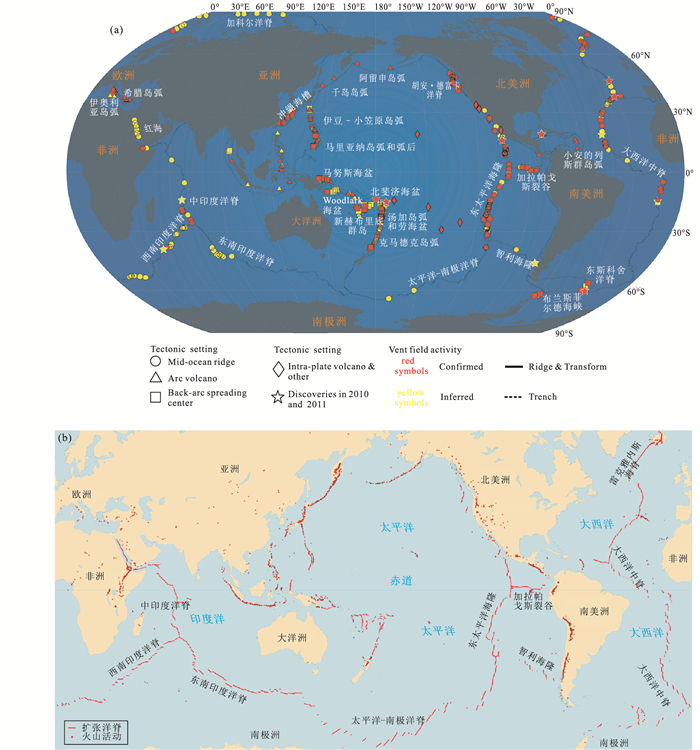
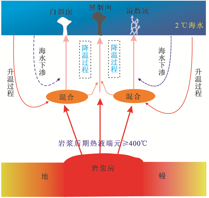
Abstract:
Modern seafloor hydrothermal activity is generally accompanied by magmatism. Traditional hydrothermal system model hypothesizes that seawater penetrates through the rifts or cracks, then is heated and reacts with the surrounding rocks gradually leaching out metal elements from the rocks and resulting in the formation of metal-rich, acidic and reductive hydrothermal fluid. Subsequently, the heated fluid moves up along a series of fissures and erupts directly out of the ocean floor leading to precipitations of hydrothermal sulfides.This model reasonably accounts for the existence of fluid, channels and heat sources which are the three fundamental elements of modern seafloor hydrothermal system, and is in accord with many phenomena we have observed so far. However, differences in rock permeability, hydrothermal fluid properties, thermal fluid ecosystem and hydrothermal product indicate that there is possibly another injected circulation pattern for modern seafloor hydrothermal systems, which means the hydrothermal fluid is derived from the direct injection of fluid and volatile components from the deep magma chamber. Accordingly, it is inferred that there possibly are two models for modern seafloor hydrothermal systems:one is the shallow circulation mode, namely the traditional mode of hydrothermal circulation; the other is a magmatic hydrothermal injection mode ("injection model"). In the environment of strong magmatism and well-developed fracture, two modes may exist simultaneously, and the double diffusive convection circulation model is proposed. The double diffusive convection circulation model can be used to explain a variety of phenomena and facts recently discovered in the study of modern seafloor hydrothermal system. Moreover, it is pointed out that the tectonic background of the subduction and the mixing of materials from both subduction component and continental crust are also considered in the study of the magmatism and hydrothermal activity in back-arc basin. Meanwhile, a theoretical model has been constructed for the sea-floor hydrothermal system in back-arc basin taking the Okinawa trough as an example.
Modern seafloor hydrothermal activity is generally accompanied by magmatism. Traditional hydrothermal system model hypothesizes that seawater penetrates through the rifts or cracks, then is heated and reacts with the surrounding rocks gradually leaching out metal elements from the rocks and resulting in the formation of metal-rich, acidic and reductive hydrothermal fluid. Subsequently, the heated fluid moves up along a series of fissures and erupts directly out of the ocean floor leading to precipitations of hydrothermal sulfides.This model reasonably accounts for the existence of fluid, channels and heat sources which are the three fundamental elements of modern seafloor hydrothermal system, and is in accord with many phenomena we have observed so far. However, differences in rock permeability, hydrothermal fluid properties, thermal fluid ecosystem and hydrothermal product indicate that there is possibly another injected circulation pattern for modern seafloor hydrothermal systems, which means the hydrothermal fluid is derived from the direct injection of fluid and volatile components from the deep magma chamber. Accordingly, it is inferred that there possibly are two models for modern seafloor hydrothermal systems:one is the shallow circulation mode, namely the traditional mode of hydrothermal circulation; the other is a magmatic hydrothermal injection mode ("injection model"). In the environment of strong magmatism and well-developed fracture, two modes may exist simultaneously, and the double diffusive convection circulation model is proposed. The double diffusive convection circulation model can be used to explain a variety of phenomena and facts recently discovered in the study of modern seafloor hydrothermal system. Moreover, it is pointed out that the tectonic background of the subduction and the mixing of materials from both subduction component and continental crust are also considered in the study of the magmatism and hydrothermal activity in back-arc basin. Meanwhile, a theoretical model has been constructed for the sea-floor hydrothermal system in back-arc basin taking the Okinawa trough as an example.


2018, 43(3): 851-861.
doi: 10.3799/dqkx.2018.908
Abstract:
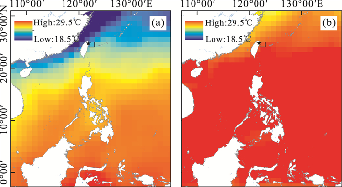
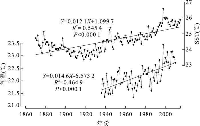
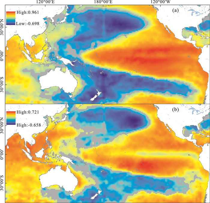
Seasonal and inter-annual anomalies of sea surface temperature (SST) are very important for recognizing modern global warming, reconstructing historical climate changes and discussing mechanisms of climate changes. However, the related researches of SST offshore northeastern Taiwan are not enough. Based on NOAA's monthly SST data, monthly SST data from Hadley Center and monthly Multivariate ENSO Index (MEI), the seasonal and inter-annual anomalies of SST and their influencing factors offshore northeastern Taiwan under the background of modern global warming are analyzed in order to further understand modern global warming and historical climate changes. On seasonal timescales, winter SST always displays greater variation range than summer SST, and its influence on the annual mean SST and SST seasonality is more serious, which could be contributed to the effects of East Asian Winter Monsoon (EAWM). Modern instrumental data and paleoclimate records show that greater variabilities of winter SST than summer SST possibly also exist on the inter-annual-centennial timescales. On inter-annual timescales, the SST anomalies offshore northeastern Taiwan exhibit a good lag correlation to MEI Index indicating the significant effect of ENSO on SST anomalies through the robust role of EAWM. It is crucial to distinguish the different multi-scales of climate change and seasonal explanations of temperature proxies when reconstructing the past temperature variation. And, insight to the responses of historical climate to ENSO and EAWM would be helpful to further understand the cause of modern global warming.
Seasonal and inter-annual anomalies of sea surface temperature (SST) are very important for recognizing modern global warming, reconstructing historical climate changes and discussing mechanisms of climate changes. However, the related researches of SST offshore northeastern Taiwan are not enough. Based on NOAA's monthly SST data, monthly SST data from Hadley Center and monthly Multivariate ENSO Index (MEI), the seasonal and inter-annual anomalies of SST and their influencing factors offshore northeastern Taiwan under the background of modern global warming are analyzed in order to further understand modern global warming and historical climate changes. On seasonal timescales, winter SST always displays greater variation range than summer SST, and its influence on the annual mean SST and SST seasonality is more serious, which could be contributed to the effects of East Asian Winter Monsoon (EAWM). Modern instrumental data and paleoclimate records show that greater variabilities of winter SST than summer SST possibly also exist on the inter-annual-centennial timescales. On inter-annual timescales, the SST anomalies offshore northeastern Taiwan exhibit a good lag correlation to MEI Index indicating the significant effect of ENSO on SST anomalies through the robust role of EAWM. It is crucial to distinguish the different multi-scales of climate change and seasonal explanations of temperature proxies when reconstructing the past temperature variation. And, insight to the responses of historical climate to ENSO and EAWM would be helpful to further understand the cause of modern global warming.


2018, 43(3): 862-872.
doi: 10.3799/dqkx.2017.505
Abstract:
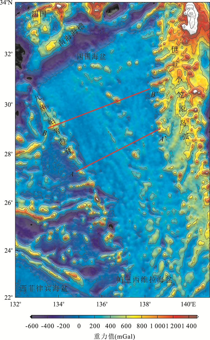
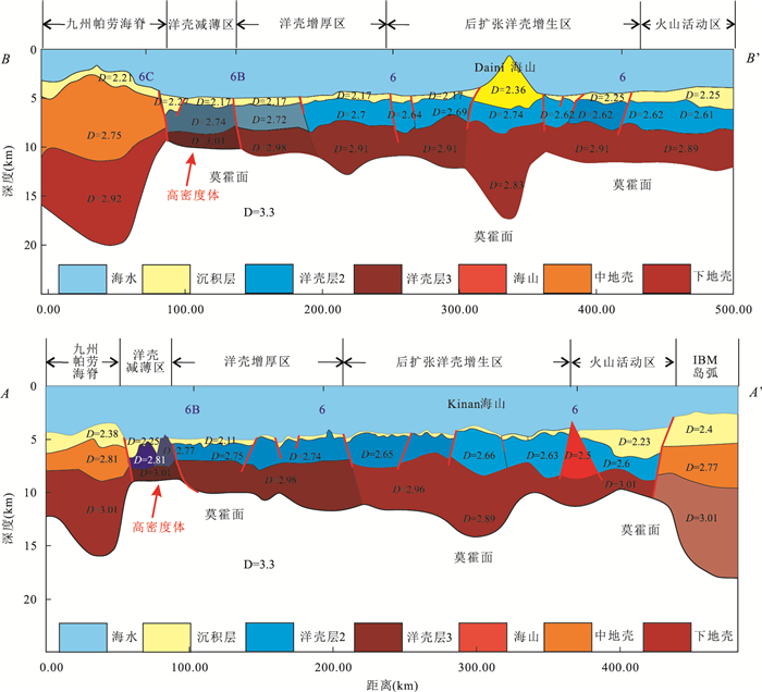
The Shikoku basin is a back-arc basin in the Philippine Sea which experienced arc rifting in Cenozoic. Study on deep structures plays an important role in understanding the break-up of the Izu-Bonin-Mariana arc and back-arc rifting history. With constraints of multi-channel seismic data and refraction seismic data, as well as the magnetic data, we carry out gravity inversion on two profiles crossing the whole Shikoku basin to study the density changes along the lines, and to reconstruct the deep structures. Results show that the oceanic crustin creases gradually from west to east, and the Moho depth increases sharply in the residual spreading ridge. According to the crustal density and thickness, we separate the Shikoku basin into three domains:the thin nedoceanic domain, the thickened oceanic domain, and the domain affected by post-spreading magmatism, which corresponds to th einitial slow spreading stage, single-wing fast spreading stage, and the symmetrical spreading stage, respectively. The spreading rate calculated from the different tectonic domains fits well with that from the magnetic omalies. High-density body exists under the oceanic crust with in thinned oceanic domain, which is correspondence with high-velocity layer in the refraction seismic velocity model. We suggest that this high-density body was formed by mantle serpentinization caused by active detachments during slow-spreading stage.
The Shikoku basin is a back-arc basin in the Philippine Sea which experienced arc rifting in Cenozoic. Study on deep structures plays an important role in understanding the break-up of the Izu-Bonin-Mariana arc and back-arc rifting history. With constraints of multi-channel seismic data and refraction seismic data, as well as the magnetic data, we carry out gravity inversion on two profiles crossing the whole Shikoku basin to study the density changes along the lines, and to reconstruct the deep structures. Results show that the oceanic crustin creases gradually from west to east, and the Moho depth increases sharply in the residual spreading ridge. According to the crustal density and thickness, we separate the Shikoku basin into three domains:the thin nedoceanic domain, the thickened oceanic domain, and the domain affected by post-spreading magmatism, which corresponds to th einitial slow spreading stage, single-wing fast spreading stage, and the symmetrical spreading stage, respectively. The spreading rate calculated from the different tectonic domains fits well with that from the magnetic omalies. High-density body exists under the oceanic crust with in thinned oceanic domain, which is correspondence with high-velocity layer in the refraction seismic velocity model. We suggest that this high-density body was formed by mantle serpentinization caused by active detachments during slow-spreading stage.


2018, 43(3): 873-886.
doi: 10.3799/dqkx.2017.513
Abstract:
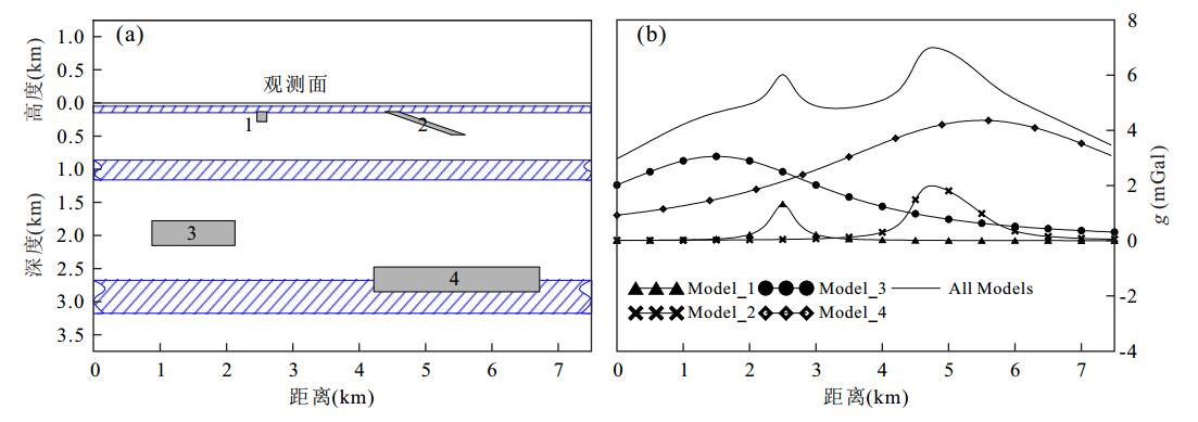
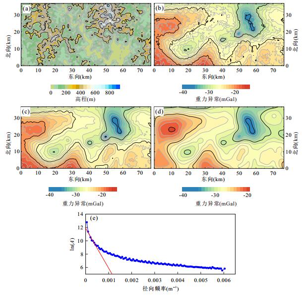
Reconstruction of discrete gravity data is an important technique in data analysis and processing. As an effective and stable approach of reconstruction, Equivalent-source method has still been the interest of geoscientists. In this paper, the frame of multi-size equivalent-sources distributing in three layers is proposed based on the theory of potential field. This approach can effectively recover long-wavelength information in observed data and is able to realize the high-precision reconstruction, so that gravity gradients can be calculated accurately on the basis of the achieved equivalent-sources. Issues on settings of three-layer equivalent sources with variable sizes and the optimization of inversion algorithm are discussed in the work. The experiments of 2D and 3D models show the effectiveness and the advantage of the method relative to the reconstructed results using single-layer equivalent-source method. The real data example from a region of Guangxi, China, is applied and its result illustrates that the method has good noise suppression and practicability.
Reconstruction of discrete gravity data is an important technique in data analysis and processing. As an effective and stable approach of reconstruction, Equivalent-source method has still been the interest of geoscientists. In this paper, the frame of multi-size equivalent-sources distributing in three layers is proposed based on the theory of potential field. This approach can effectively recover long-wavelength information in observed data and is able to realize the high-precision reconstruction, so that gravity gradients can be calculated accurately on the basis of the achieved equivalent-sources. Issues on settings of three-layer equivalent sources with variable sizes and the optimization of inversion algorithm are discussed in the work. The experiments of 2D and 3D models show the effectiveness and the advantage of the method relative to the reconstructed results using single-layer equivalent-source method. The real data example from a region of Guangxi, China, is applied and its result illustrates that the method has good noise suppression and practicability.


2018, 43(3): 887-898.
doi: 10.3799/dqkx.2018.909
Abstract:
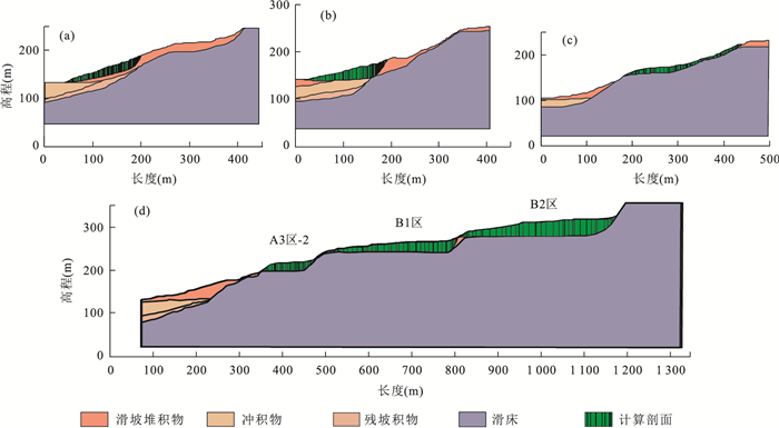
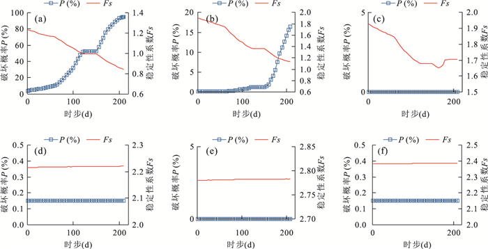
The GPS monitoring cumulative displacement on reservoir landslides in the Three Gorges Reservoir area shows step-like characteristics and is a probable chaotic time series under the influences of the seasonal rainfall and reservoir water level fluctuation. Traditionally, the uni-variable chaotic model is commonly used to predict the landslide displacement; and all existing multivariable models select the input variables empirically without theoretical exploration of the nonlinear dynamic evolution process of landslide displacement and its inducing factors. A new combined model based on double exponential smoothing (DES), multivariable chaotic model, extreme learning machine (ELM) is proposed in this study. First, the chaos characteristic of landslide displacement is identified by the combined DES and multivariable chaotic ELM. Second, the DES method is used to predict the cumulative displacement. The predictive results are the trend displacement, and the periodic displacement is obtained by reducing the trend displacement from the cumulative displacement. Third, the multivariate phase space reconstruction method of chaotic theory is used to explore the dynamic relationship between the periodic displacement and its inducing factors, and the ELM model is established to predict the periodic displacement. Finally, the total forecast cumulative displacement is obtained by adding the predictive trend and periodic displacement. The GPS monitoring cumulative displacement on the Baishuihe landslide is used as case study. In addition, the proposed model is compared with the combined DES and multivariable chaotic particle swarm optimized support vector machine model, the combined DES and uni-variable chaotic ELM model. The results show that the prediction accuracy of the proposed model is higher than that of other models. The proposed model explores the nonlinear characteristic of landslide displacement and its dynamic relationship with inducing factors. The model also reflects the physical meaning of the nonlinear evolution of the landslide displacement.
The GPS monitoring cumulative displacement on reservoir landslides in the Three Gorges Reservoir area shows step-like characteristics and is a probable chaotic time series under the influences of the seasonal rainfall and reservoir water level fluctuation. Traditionally, the uni-variable chaotic model is commonly used to predict the landslide displacement; and all existing multivariable models select the input variables empirically without theoretical exploration of the nonlinear dynamic evolution process of landslide displacement and its inducing factors. A new combined model based on double exponential smoothing (DES), multivariable chaotic model, extreme learning machine (ELM) is proposed in this study. First, the chaos characteristic of landslide displacement is identified by the combined DES and multivariable chaotic ELM. Second, the DES method is used to predict the cumulative displacement. The predictive results are the trend displacement, and the periodic displacement is obtained by reducing the trend displacement from the cumulative displacement. Third, the multivariate phase space reconstruction method of chaotic theory is used to explore the dynamic relationship between the periodic displacement and its inducing factors, and the ELM model is established to predict the periodic displacement. Finally, the total forecast cumulative displacement is obtained by adding the predictive trend and periodic displacement. The GPS monitoring cumulative displacement on the Baishuihe landslide is used as case study. In addition, the proposed model is compared with the combined DES and multivariable chaotic particle swarm optimized support vector machine model, the combined DES and uni-variable chaotic ELM model. The results show that the prediction accuracy of the proposed model is higher than that of other models. The proposed model explores the nonlinear characteristic of landslide displacement and its dynamic relationship with inducing factors. The model also reflects the physical meaning of the nonlinear evolution of the landslide displacement.


2018, 43(3): 899-909.
doi: 10.3799/dqkx.2018.910
Abstract:
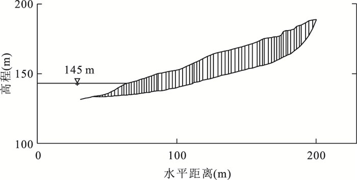
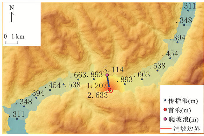
The reservoir landslide and its generated surge are major disasters in the operation of reservoir water and their influence degree on life and property can be reasonably determined and evaluated.by risk analysis, which shall provide theoretical basis and technical support for economical and effective emergency measures of disaster reduction. Tangjiao No.1 landslide, in Wanzhou District, Three Gorges Reservoir, was taken as an example in this study. Firstly, the method of hazard analysis on individual landslide by considering the spatial difference and different water levels and rainfall scenarios was discussed. Secondly, the impact range of landslide generated wave was determined. Thirdly, the methods of vulnerability analysis on the elements at risk in the impact range of landslide and its generated wave were studied. Finally, under the most dangerous scenario, economic risk map of Tangshan No. 1 landslide and its generated wave and population risk map of Tangshan No. 1 landslide were obtained. The results show that the most dangerous scenario for Tangshan No. 1 landslide was water level decreasing from 175 m to 145 m with a 3-day-rain of 100 mm daily rainfall. Under this scenario, the total economic risk of Tangshan No. 1 landslide and its generated wave was 22.39 million RMB; the total indoor population risk of the landslide was 0.55 person. The results of this study could be used in guiding reservoir bank landslide disaster prevention and mitigation.
The reservoir landslide and its generated surge are major disasters in the operation of reservoir water and their influence degree on life and property can be reasonably determined and evaluated.by risk analysis, which shall provide theoretical basis and technical support for economical and effective emergency measures of disaster reduction. Tangjiao No.1 landslide, in Wanzhou District, Three Gorges Reservoir, was taken as an example in this study. Firstly, the method of hazard analysis on individual landslide by considering the spatial difference and different water levels and rainfall scenarios was discussed. Secondly, the impact range of landslide generated wave was determined. Thirdly, the methods of vulnerability analysis on the elements at risk in the impact range of landslide and its generated wave were studied. Finally, under the most dangerous scenario, economic risk map of Tangshan No. 1 landslide and its generated wave and population risk map of Tangshan No. 1 landslide were obtained. The results show that the most dangerous scenario for Tangshan No. 1 landslide was water level decreasing from 175 m to 145 m with a 3-day-rain of 100 mm daily rainfall. Under this scenario, the total economic risk of Tangshan No. 1 landslide and its generated wave was 22.39 million RMB; the total indoor population risk of the landslide was 0.55 person. The results of this study could be used in guiding reservoir bank landslide disaster prevention and mitigation.


2018, 43(3): 910-921.
doi: 10.3799/dqkx.2017.564
Abstract:
High iodine groundwater is another global drinking water safety problem in addition to after high arsenic and high fluorine groundwater. However, the research on the existing forms of iodine and the mechanisms of migration and enrichment of iodine in groundwater system is still insufficient research on the existing forms of iodine and the mechanisms of migration and enrichment of iodine in groundwater system. To understand spatial distribution and mobilization of iodine in groundwater system of North China plain(NCP), a hydrochemical study was conducted. The results show that iodine concentration in groundwater from NCP rangesd from 3.35 to 1 106 μg/L, and 41.86% of groundwater samples has iodine concentration exceeding drinking water level (150 μg/L) recommended by Chinese government. High iodine groundwater (>150 μg/L) is mainly distributed in deep aquifers of Bohai bay area. The main species of groundwater iodine include mainly diodide and iodate, the distribution of which is controlled by redox environment of groundwater, and iodate mainly occurs in oxidizing condition. Along the groundwater flow path from Shijiazhuang, Hengshui to Cangzhou, hydrochemical evolution and inverse modeling were performed to understand the groundwater environment favoring iodine enrichment in groundwater. The results of hydrochemical evolution showed that at Bohai bay area, the weak-alkalinity and (sub)reducing environment influenced by seawater intrusion favor the iodine release and enrichment in groundwater.The adsorption equilibration of iodine among metal oxyhydroxides under various environments is the primary hydrogeochemical process controlling iodine mobilization in the groundwater system of the North China plain.
High iodine groundwater is another global drinking water safety problem in addition to after high arsenic and high fluorine groundwater. However, the research on the existing forms of iodine and the mechanisms of migration and enrichment of iodine in groundwater system is still insufficient research on the existing forms of iodine and the mechanisms of migration and enrichment of iodine in groundwater system. To understand spatial distribution and mobilization of iodine in groundwater system of North China plain(NCP), a hydrochemical study was conducted. The results show that iodine concentration in groundwater from NCP rangesd from 3.35 to 1 106 μg/L, and 41.86% of groundwater samples has iodine concentration exceeding drinking water level (150 μg/L) recommended by Chinese government. High iodine groundwater (>150 μg/L) is mainly distributed in deep aquifers of Bohai bay area. The main species of groundwater iodine include mainly diodide and iodate, the distribution of which is controlled by redox environment of groundwater, and iodate mainly occurs in oxidizing condition. Along the groundwater flow path from Shijiazhuang, Hengshui to Cangzhou, hydrochemical evolution and inverse modeling were performed to understand the groundwater environment favoring iodine enrichment in groundwater. The results of hydrochemical evolution showed that at Bohai bay area, the weak-alkalinity and (sub)reducing environment influenced by seawater intrusion favor the iodine release and enrichment in groundwater.The adsorption equilibration of iodine among metal oxyhydroxides under various environments is the primary hydrogeochemical process controlling iodine mobilization in the groundwater system of the North China plain.


2018, 43(3): 922-932.
doi: 10.3799/dqkx.2017.580
Abstract:
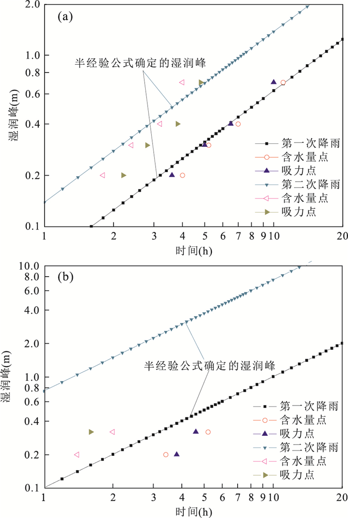
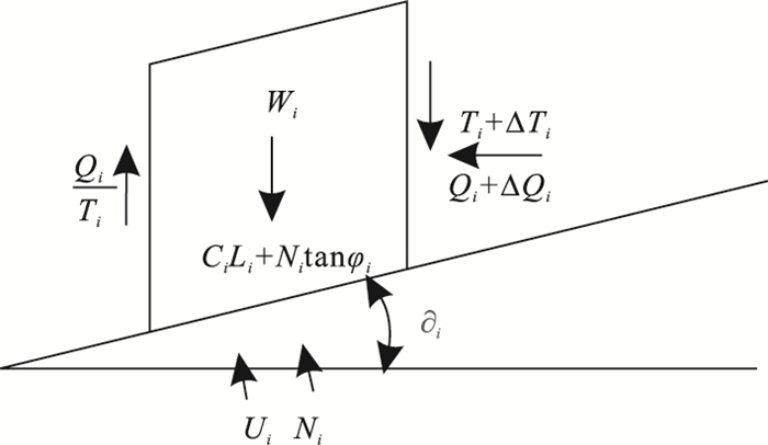
In order to analyze unsaturated seepage characteristics of slope under rainfall infiltration, a rainfall simulation system and real-time monitoring system were employed for conducting model tests to simulate the rainfall-induced unsaturated soil slope failure process in this study. The real-time response of infiltration rate and wetting front of soil slope with different slope angles, different compaction degrees and different locations under different rainfall conditions were recorded and analyzed. Results show that steep slope and high compaction degree soil are not conducive to rainfall infiltration, while gentle slope and low compaction degree soil have a quick change of infiltration rate; the concept of test wetting front is proposed due to the real-time law of actual soil suction and water content under rainfall conditions are not synchronized, and the water content (suction) wetting front point can be determined by a linear intersection of water content (suction) real-time curve transition zone and residual water content (suction) after rainfall; considering water content and soil suction have the only corresponding relationship under unidirectional wetting and drying path, the time needed for wetting front formation can be seen as the absolute value of time differences between water content and suction wetting front point. Based on the Lumb formula of wetting front depth, the nonlinear correction expression is proposed subsequently by comparing the scatter distribution of wetting front measured and semi-empirical values.
In order to analyze unsaturated seepage characteristics of slope under rainfall infiltration, a rainfall simulation system and real-time monitoring system were employed for conducting model tests to simulate the rainfall-induced unsaturated soil slope failure process in this study. The real-time response of infiltration rate and wetting front of soil slope with different slope angles, different compaction degrees and different locations under different rainfall conditions were recorded and analyzed. Results show that steep slope and high compaction degree soil are not conducive to rainfall infiltration, while gentle slope and low compaction degree soil have a quick change of infiltration rate; the concept of test wetting front is proposed due to the real-time law of actual soil suction and water content under rainfall conditions are not synchronized, and the water content (suction) wetting front point can be determined by a linear intersection of water content (suction) real-time curve transition zone and residual water content (suction) after rainfall; considering water content and soil suction have the only corresponding relationship under unidirectional wetting and drying path, the time needed for wetting front formation can be seen as the absolute value of time differences between water content and suction wetting front point. Based on the Lumb formula of wetting front depth, the nonlinear correction expression is proposed subsequently by comparing the scatter distribution of wetting front measured and semi-empirical values.