2018 Vol. 43, No. 6
Display Method:
 PDF 319KB
2018, 43(6): 1817-1829.
doi: 10.3799/dqkx.2018.605
Abstract:
Petroleum characteristics and accumulation of the marine superimposed basins show strong complexity, which makes it difficult to determine key time of reservoir accumulation. It is urgent to establish effective dating methods for hydrocarbon source age, hydrocarbon generation and expulsion time, reservoir adjustment and stabilization time. On the basis of helium age accumulation effect and reservoir preservation mechanism, the helium dating model and age estimating formulas are put forward to determine the time of reservoir formation and stabilization retention after large scale of petroleum charging in this paper. According to the relationships between the 40Ar/36Ar ratio of natural gas, potassium abundance of source rock and the geological time, argon isotopic estimation model on the source rock age is fitting by many parameters. Based on the closure temperature on U-Th/He dating system of apatite and zircon being consistent with the temperature scope of hydrocarbon generation in sedimentary basin, uplift time and reservoir transformation time induced by tectonic uplift are revealed by means of time and closure temperature difference of close system in apatite and zircon, and geothermal gradient of sedimentary basin. By means of a series of condition test, pretreatment techniques including asphaltene extraction, acid dissolving, rhenium-osmium purity, enrichment and separation are established. Re-Os isotopic dating can be used to directly date hydrocarbon source rock, solid bitumen, oil and oil sand and offer hydrocarbon generation and migration time. According to priority of the formation time or occurrence time of geological part of reservoir, the key dating technologies to determine source rock age, hydrocarbon generating time, charging time, reservoir adjustment and stabilization time are established. By means of dating technologies, the key time including source rock age, hydrocarbon charging time, gas reservoir adjustment and stabilization time are determined in Yuanba gas field in Sichuan basin. It is indicated that the main gas source is composed of the Longtan Formation hydrocarbon source rocks, and two stages crude oil charging time being from 220 Ma to 175 Ma and from 168 Ma to 140 Ma, large scale crude oil began to crack into gas between 140 Ma and 118 Ma.Tectonic uplift began to occur since 97 Ma, especially since 15 Ma, gas and water interface began to adjust until gas reservoir kept stabilization between 12 Ma and 8 Ma.
Petroleum characteristics and accumulation of the marine superimposed basins show strong complexity, which makes it difficult to determine key time of reservoir accumulation. It is urgent to establish effective dating methods for hydrocarbon source age, hydrocarbon generation and expulsion time, reservoir adjustment and stabilization time. On the basis of helium age accumulation effect and reservoir preservation mechanism, the helium dating model and age estimating formulas are put forward to determine the time of reservoir formation and stabilization retention after large scale of petroleum charging in this paper. According to the relationships between the 40Ar/36Ar ratio of natural gas, potassium abundance of source rock and the geological time, argon isotopic estimation model on the source rock age is fitting by many parameters. Based on the closure temperature on U-Th/He dating system of apatite and zircon being consistent with the temperature scope of hydrocarbon generation in sedimentary basin, uplift time and reservoir transformation time induced by tectonic uplift are revealed by means of time and closure temperature difference of close system in apatite and zircon, and geothermal gradient of sedimentary basin. By means of a series of condition test, pretreatment techniques including asphaltene extraction, acid dissolving, rhenium-osmium purity, enrichment and separation are established. Re-Os isotopic dating can be used to directly date hydrocarbon source rock, solid bitumen, oil and oil sand and offer hydrocarbon generation and migration time. According to priority of the formation time or occurrence time of geological part of reservoir, the key dating technologies to determine source rock age, hydrocarbon generating time, charging time, reservoir adjustment and stabilization time are established. By means of dating technologies, the key time including source rock age, hydrocarbon charging time, gas reservoir adjustment and stabilization time are determined in Yuanba gas field in Sichuan basin. It is indicated that the main gas source is composed of the Longtan Formation hydrocarbon source rocks, and two stages crude oil charging time being from 220 Ma to 175 Ma and from 168 Ma to 140 Ma, large scale crude oil began to crack into gas between 140 Ma and 118 Ma.Tectonic uplift began to occur since 97 Ma, especially since 15 Ma, gas and water interface began to adjust until gas reservoir kept stabilization between 12 Ma and 8 Ma.


2018, 43(6): 1830-1838.
doi: 10.3799/dqkx.2018.609
Abstract:
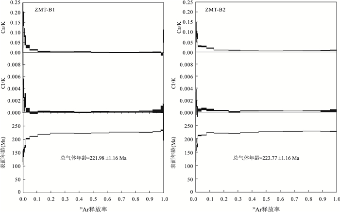
The Pangxidong fault zone is one of many NE-strength ductile shear zones in the southern section of the Qin-Hang metallogenic belt and controls the distribution of a series of ductile shear zones related Ag-Au deposits. Study on its thermochronology is helpful to understand the tectonic evolution of the NE-trending ductile shear zone in the southern part of the Qin-Hang metallogenic belt and its effect on the associated mineral deposits. A set of muscovite 40Ar/39Ar and fission track analysis were carried out in this paper. Two muscovite samples from the mylonite yielded 40Ar/39Ar isotopic total gas ages of 221.98±1.16 Ma and 223.77±1.16 Ma, respectively. It is interpreted that the ductile shearing happened in Pangxidong fault zone during the Indosinian period, which is believed to have provided favorable space for the formation of associated mineral deposits.Apatite and zircon fission track ages from the same mylonite sample yield 64.83±4.13 Ma and 75.69±2.88 Ma, respectively. Combined with the thermal history modeling results, it is shown that the fault zone had experienced a rapid cooling process during~75-60 Ma(6.2 ℃/Ma), which is much different from the slow cooling process of the Yunkai region (1.5 ℃/Ma). The results suggest that the Pangxidong fault zone was active again during~75-60 Ma and the Pangxidong Ag-Au deposits possibly formed in the Late Cretaceous.
The Pangxidong fault zone is one of many NE-strength ductile shear zones in the southern section of the Qin-Hang metallogenic belt and controls the distribution of a series of ductile shear zones related Ag-Au deposits. Study on its thermochronology is helpful to understand the tectonic evolution of the NE-trending ductile shear zone in the southern part of the Qin-Hang metallogenic belt and its effect on the associated mineral deposits. A set of muscovite 40Ar/39Ar and fission track analysis were carried out in this paper. Two muscovite samples from the mylonite yielded 40Ar/39Ar isotopic total gas ages of 221.98±1.16 Ma and 223.77±1.16 Ma, respectively. It is interpreted that the ductile shearing happened in Pangxidong fault zone during the Indosinian period, which is believed to have provided favorable space for the formation of associated mineral deposits.Apatite and zircon fission track ages from the same mylonite sample yield 64.83±4.13 Ma and 75.69±2.88 Ma, respectively. Combined with the thermal history modeling results, it is shown that the fault zone had experienced a rapid cooling process during~75-60 Ma(6.2 ℃/Ma), which is much different from the slow cooling process of the Yunkai region (1.5 ℃/Ma). The results suggest that the Pangxidong fault zone was active again during~75-60 Ma and the Pangxidong Ag-Au deposits possibly formed in the Late Cretaceous.


2018, 43(6): 1839-1849.
doi: 10.3799/dqkx.2018.596
Abstract:
The recovery of exhumation history of oil shale with the method of geothermometer and thermochronology has scientific significance for the study of thermal background of oil shale mineralization and its reformation. Based on the theory of tectonothermal evolution, the paleogeotemperature, the exhumation-related cooling and the erosion of the Triassic oil shale since Late Cretaceous in the Binxian area and the Tongchuan area were recovered with the fission track data from the well Yongcan1 and the (U-Th)/He data from the drilling well ZK900, respectively. The tectonothermal evolution difference of the two areas are discussed. The average (U-Th)/He ages of the Chang6, Chang9 and Chang10 samples are 43.83 Ma, 31.87 Ma, and 22.88 Ma respectively. Three stages of exhumation-cooling since Late Cretaceous of the Tongchuan area were recovered:97-40 Ma, fast exhumation; 40-8 Ma, slow exhumation, and 8 Ma to the present, extremely fast exhumation, respectively. The erosion thickness and exhumation rate are 600 m, 10.5 m/Ma and 10 m, 0.3 m/Ma and 1 290 m, 161.3 m/Ma, respectively. The paleotemperature and cooling rate are 100-60 ℃, 0.70 ℃/Ma and 60-50 ℃, 0.22 ℃/Ma and 50-25 ℃, 2.90 ℃/Ma, respectively. Three stages of exhumation-cooling since Late Cretaceous of the Triassic in the Binxian area were recovered:97-40 Ma, increasing exhumation-cooling (130-75 ℃), cooling rate of 0.96 ℃/Ma, exhumation rate of 14.4 m/Ma, erosion thickness of 820 m; 40-8 Ma with little changed as 75-70 ℃, exhumation rate/cooling rate, 0.16 ℃/Ma and 1.9 m/Ma, erosion thickness of 60 m; 8 Ma to the present with sharp cooling as 70-31 ℃, exhumation rate of 125 m/Ma, cooling rate of 4.88 ℃/Ma, erosion thickness of 1 000 m, respectively. There are three stages for the exhumation-cooling history of the oil shale (Triassic in the Binxian-Tongchuan area). The Eocene (40 Ma) and the Late Miocene (8 Ma) are the critical moments for the cooling of the oil shale during its mineralization. More attention should be paid to the differences of exhumation, cooling, erosion between Binxian area and Tongchuan area when discussing the mineralization of the oil shale and its reformation in the Ordos basin.
The recovery of exhumation history of oil shale with the method of geothermometer and thermochronology has scientific significance for the study of thermal background of oil shale mineralization and its reformation. Based on the theory of tectonothermal evolution, the paleogeotemperature, the exhumation-related cooling and the erosion of the Triassic oil shale since Late Cretaceous in the Binxian area and the Tongchuan area were recovered with the fission track data from the well Yongcan1 and the (U-Th)/He data from the drilling well ZK900, respectively. The tectonothermal evolution difference of the two areas are discussed. The average (U-Th)/He ages of the Chang6, Chang9 and Chang10 samples are 43.83 Ma, 31.87 Ma, and 22.88 Ma respectively. Three stages of exhumation-cooling since Late Cretaceous of the Tongchuan area were recovered:97-40 Ma, fast exhumation; 40-8 Ma, slow exhumation, and 8 Ma to the present, extremely fast exhumation, respectively. The erosion thickness and exhumation rate are 600 m, 10.5 m/Ma and 10 m, 0.3 m/Ma and 1 290 m, 161.3 m/Ma, respectively. The paleotemperature and cooling rate are 100-60 ℃, 0.70 ℃/Ma and 60-50 ℃, 0.22 ℃/Ma and 50-25 ℃, 2.90 ℃/Ma, respectively. Three stages of exhumation-cooling since Late Cretaceous of the Triassic in the Binxian area were recovered:97-40 Ma, increasing exhumation-cooling (130-75 ℃), cooling rate of 0.96 ℃/Ma, exhumation rate of 14.4 m/Ma, erosion thickness of 820 m; 40-8 Ma with little changed as 75-70 ℃, exhumation rate/cooling rate, 0.16 ℃/Ma and 1.9 m/Ma, erosion thickness of 60 m; 8 Ma to the present with sharp cooling as 70-31 ℃, exhumation rate of 125 m/Ma, cooling rate of 4.88 ℃/Ma, erosion thickness of 1 000 m, respectively. There are three stages for the exhumation-cooling history of the oil shale (Triassic in the Binxian-Tongchuan area). The Eocene (40 Ma) and the Late Miocene (8 Ma) are the critical moments for the cooling of the oil shale during its mineralization. More attention should be paid to the differences of exhumation, cooling, erosion between Binxian area and Tongchuan area when discussing the mineralization of the oil shale and its reformation in the Ordos basin.


2018, 43(6): 1850-1860.
doi: 10.3799/dqkx.2018.610
Abstract:
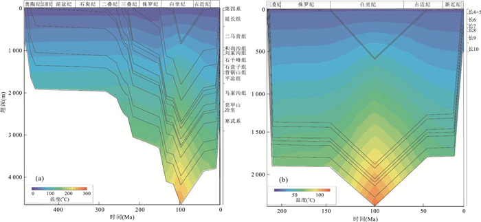
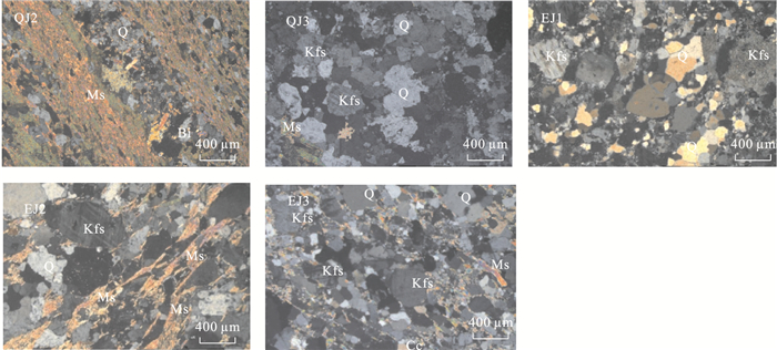
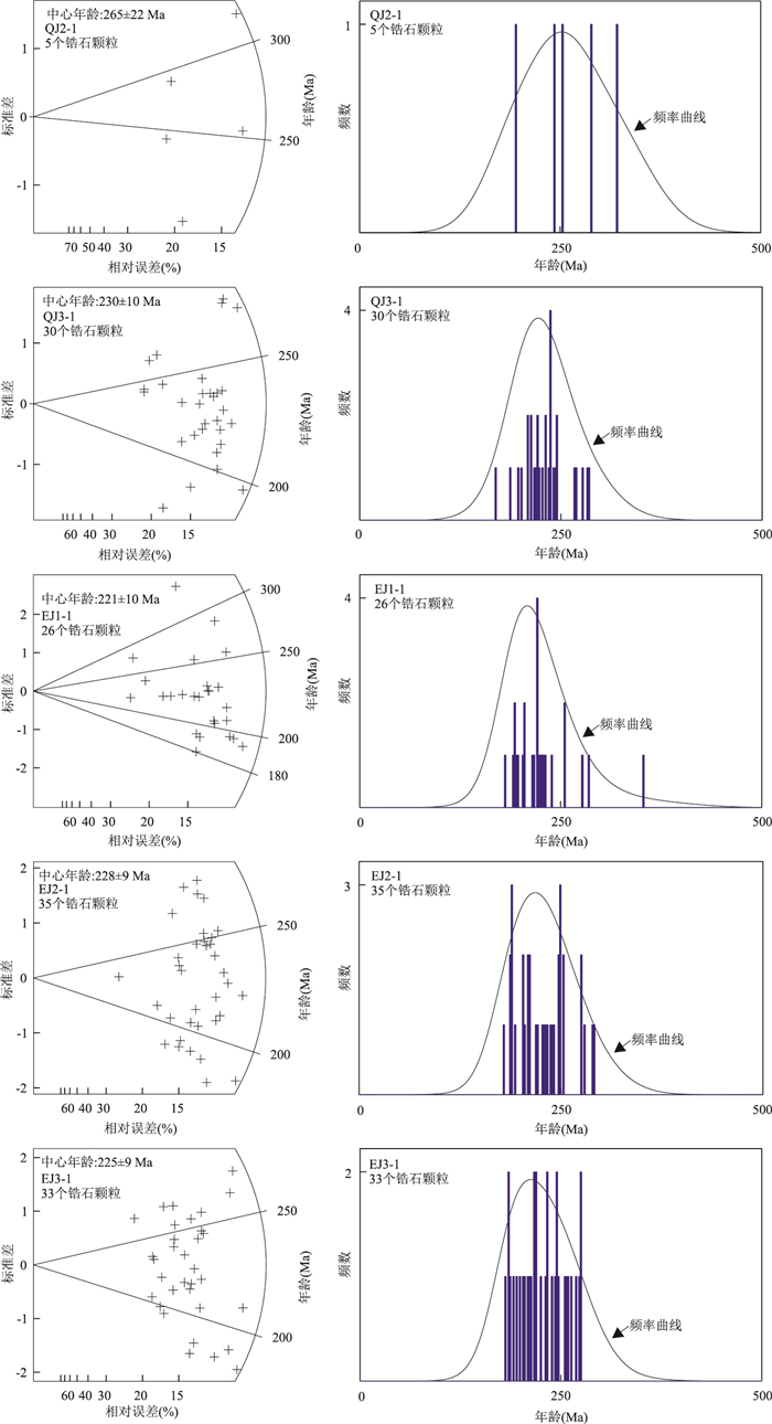
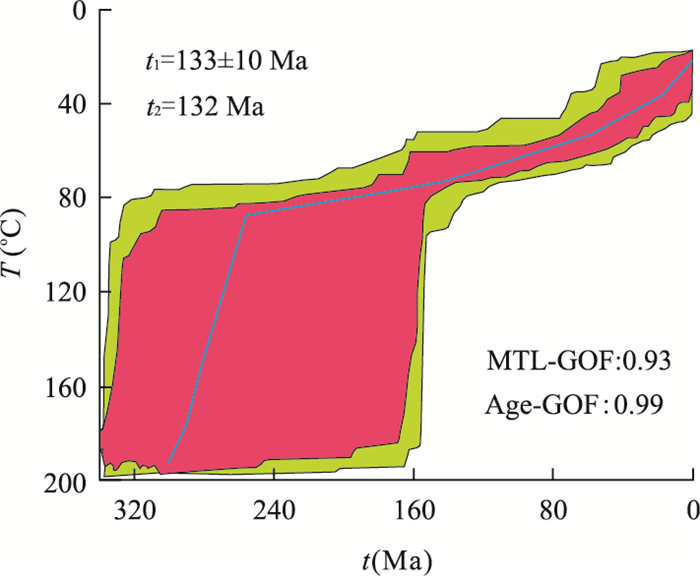
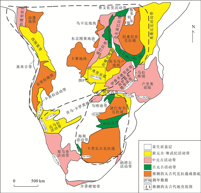
The fission track chronology of zircon and apatite are always used to reveal tectonic activities and evolutions. Based on zircon and apatite fission track analyses and thermal evolution history, in this paper, it discusses the tectonic thermal evolution process of Lufilian arc since the Pan-African tectonic movement. The Chambishi copper and the Nchanga copper and cobalt deposits occur in the Zambian Copper belt of the Lufilian arc. Five fresh rock samples were taken from these two deposits, from which 5 zircon samples and 4 apatite samples were obtained. For the first time we obtained the fission track ages in Lufilian arc. The results are as follow:the ages from the 5 zircon analysis are 265±22 Ma, 230±10 Ma, 228±9 Ma, 225±9 Ma and 221±10 Ma respectively and those of the 4 apatite samples are 145±10 Ma, 133±10 Ma, 130±10 Ma and 92±9 Ma respectively and the length is between 11.4±2.4 μm and 11.8±2.4 μm. According to the modeling results of ecological thermal evolution history, from 300 Ma to 260 Ma the paleo-geotemperature continued to decrease to about 90 ℃ and it subsequently slowed down to the present surface temperature. Comparing the ages of the Lufilian belt with the Zambezi and Damara belts, it is believed that the Permian-Jurassic tectonic activities were regional tectonic reactive events in the Central and Southern Africa.
The fission track chronology of zircon and apatite are always used to reveal tectonic activities and evolutions. Based on zircon and apatite fission track analyses and thermal evolution history, in this paper, it discusses the tectonic thermal evolution process of Lufilian arc since the Pan-African tectonic movement. The Chambishi copper and the Nchanga copper and cobalt deposits occur in the Zambian Copper belt of the Lufilian arc. Five fresh rock samples were taken from these two deposits, from which 5 zircon samples and 4 apatite samples were obtained. For the first time we obtained the fission track ages in Lufilian arc. The results are as follow:the ages from the 5 zircon analysis are 265±22 Ma, 230±10 Ma, 228±9 Ma, 225±9 Ma and 221±10 Ma respectively and those of the 4 apatite samples are 145±10 Ma, 133±10 Ma, 130±10 Ma and 92±9 Ma respectively and the length is between 11.4±2.4 μm and 11.8±2.4 μm. According to the modeling results of ecological thermal evolution history, from 300 Ma to 260 Ma the paleo-geotemperature continued to decrease to about 90 ℃ and it subsequently slowed down to the present surface temperature. Comparing the ages of the Lufilian belt with the Zambezi and Damara belts, it is believed that the Permian-Jurassic tectonic activities were regional tectonic reactive events in the Central and Southern Africa.


2018, 43(6): 1861-1871.
doi: 10.3799/dqkx.2018.600
Abstract:
In recent years, with the continuous improvement of isotopic thermochronologic theory system, the test and simulation technology, the isotopic thermochronology has become the hot subject of basic geological research and conventional oil and gas exploration field. However, the systematic application of the system in the field of geological evaluation for shale gas exploration and development is still less concerned. Therefore, based on the comprehensive evaluation system of shale gas exploration and development and the related theories of isotopic thermochronology, combined with the exploration and development practice of several shale strata in South China of recent years, this paper suggests that isotopic geochronology is the core index in shale stratigraphy correlation, hydrocarbon generation and expulsion history, tectonic thermal evolution history, reservoir characteristics, preservation condition evaluation in shale source evaluation (such as uplift and denudation time, recovery of denudation and active period of fracture) and compressible shale. These aspects can be used as effective technical method. It shows that the application of isotopic thermochronology can be widely applied to the field of shale gas exploration and development.
In recent years, with the continuous improvement of isotopic thermochronologic theory system, the test and simulation technology, the isotopic thermochronology has become the hot subject of basic geological research and conventional oil and gas exploration field. However, the systematic application of the system in the field of geological evaluation for shale gas exploration and development is still less concerned. Therefore, based on the comprehensive evaluation system of shale gas exploration and development and the related theories of isotopic thermochronology, combined with the exploration and development practice of several shale strata in South China of recent years, this paper suggests that isotopic geochronology is the core index in shale stratigraphy correlation, hydrocarbon generation and expulsion history, tectonic thermal evolution history, reservoir characteristics, preservation condition evaluation in shale source evaluation (such as uplift and denudation time, recovery of denudation and active period of fracture) and compressible shale. These aspects can be used as effective technical method. It shows that the application of isotopic thermochronology can be widely applied to the field of shale gas exploration and development.


2018, 43(6): 1872-1886.
doi: 10.3799/dqkx.2018.597
Abstract:
The Meso-Cenozoic Upper Yangtze continental basin is not only the core tectonic unit of the South China continent, but also a natural laboratory for the study of continental tectonics and basin genetic evolution. Based on LA-ICP-MS apatite FT-U/Pb double dating and thermal evolution history simulation of 6 samples in the Cretaceous stratigraphic Section of Chuxiong basin and Sichuan basin, this paper reveals the differential uplift and denudation and differentiation process of the Upper Yangtze basin. The AFT(apatite fission track) ages and track length of Jiangdihe Formation in the Yijiu Section of Dayao County in Chuxiong basin are dominated with 43.2-33.9 Ma and 10.06-11.30 μm, respectively. The thermal models suggest a rapid cooling occurred in Miocene with rates of 3-5 ℃/Ma. Whilst the AFT ages and track length in the Liujia Section of Yibin County in Sichuan basin are dominated with 128.0-95.2 Ma and 10.2-11.7 μm, as a result of partial reset. Furthermore, the apatite U-Pb ages are consistent between the Yijiu and Liujia sections, characterized with peak-ages of 2 100-1 700 Ma, 820-700 Ma, 500-400 Ma, and 250-170 Ma, which indicates the Upper Yangtze basin had provenances from the Songpan-Ganzi flysch, Yidun arc, Kangdian paleo-uplift and Qinling orogen in Late Cretaceous. In particular, the contrast of apatite FT-U/Pb reveals that a few of apatite minerals from Sanhe-Gaokanba Formation stemmed from a first-cycle deposit of provenance with rapid cooling of granites during Late Triassic to Cretaceous. In the end, the Upper Yangtze basin has been dispersed and fragmented with a rapid cooling and uplift in Miocene, and then forms the current basin framework, as a result of southeastward growth of Tibetan plateau.
The Meso-Cenozoic Upper Yangtze continental basin is not only the core tectonic unit of the South China continent, but also a natural laboratory for the study of continental tectonics and basin genetic evolution. Based on LA-ICP-MS apatite FT-U/Pb double dating and thermal evolution history simulation of 6 samples in the Cretaceous stratigraphic Section of Chuxiong basin and Sichuan basin, this paper reveals the differential uplift and denudation and differentiation process of the Upper Yangtze basin. The AFT(apatite fission track) ages and track length of Jiangdihe Formation in the Yijiu Section of Dayao County in Chuxiong basin are dominated with 43.2-33.9 Ma and 10.06-11.30 μm, respectively. The thermal models suggest a rapid cooling occurred in Miocene with rates of 3-5 ℃/Ma. Whilst the AFT ages and track length in the Liujia Section of Yibin County in Sichuan basin are dominated with 128.0-95.2 Ma and 10.2-11.7 μm, as a result of partial reset. Furthermore, the apatite U-Pb ages are consistent between the Yijiu and Liujia sections, characterized with peak-ages of 2 100-1 700 Ma, 820-700 Ma, 500-400 Ma, and 250-170 Ma, which indicates the Upper Yangtze basin had provenances from the Songpan-Ganzi flysch, Yidun arc, Kangdian paleo-uplift and Qinling orogen in Late Cretaceous. In particular, the contrast of apatite FT-U/Pb reveals that a few of apatite minerals from Sanhe-Gaokanba Formation stemmed from a first-cycle deposit of provenance with rapid cooling of granites during Late Triassic to Cretaceous. In the end, the Upper Yangtze basin has been dispersed and fragmented with a rapid cooling and uplift in Miocene, and then forms the current basin framework, as a result of southeastward growth of Tibetan plateau.


2018, 43(6): 1887-1902.
doi: 10.3799/dqkx.2018.606
Abstract:
Isotopic geochronology, a traditional subject to obtain absolute isotopic ages based on radioactive decay theory, has been widely used to date geological time in various fields. With theoretical innovation and technical developments, the isotopic geochronology gradually develops into the thermochronology that is of closure temperature feature and could not only date geological event, but also ascertain both temperature and thermal history of economic geological event. Since various methods have different closure temperatures, several thermochronology techniques could be synthetically applied to recover whole geological evolution history in a wide range of temperature and/or age. The thermochronology methods are especially used to reveal mineralization ages and epochs, rates of exhumation-erosion of ore deposit or ore district, and ore deposit preservation potential, providing evidences for deep ore prospecting and mineralizing potentiality evaluation.This paper summarizes the middle-low temperature thermochronology methods that have been utilized in mineralization, such as 40Ar/39Ar, fission track and (U-Th)/He techniques, and then presents research developments. It is expected that this work should provide new research contents and helpful technical methods for ore deposit field.
Isotopic geochronology, a traditional subject to obtain absolute isotopic ages based on radioactive decay theory, has been widely used to date geological time in various fields. With theoretical innovation and technical developments, the isotopic geochronology gradually develops into the thermochronology that is of closure temperature feature and could not only date geological event, but also ascertain both temperature and thermal history of economic geological event. Since various methods have different closure temperatures, several thermochronology techniques could be synthetically applied to recover whole geological evolution history in a wide range of temperature and/or age. The thermochronology methods are especially used to reveal mineralization ages and epochs, rates of exhumation-erosion of ore deposit or ore district, and ore deposit preservation potential, providing evidences for deep ore prospecting and mineralizing potentiality evaluation.This paper summarizes the middle-low temperature thermochronology methods that have been utilized in mineralization, such as 40Ar/39Ar, fission track and (U-Th)/He techniques, and then presents research developments. It is expected that this work should provide new research contents and helpful technical methods for ore deposit field.

2018, 43(6): 1903-1920.
doi: 10.3799/dqkx.2018.532
Abstract:
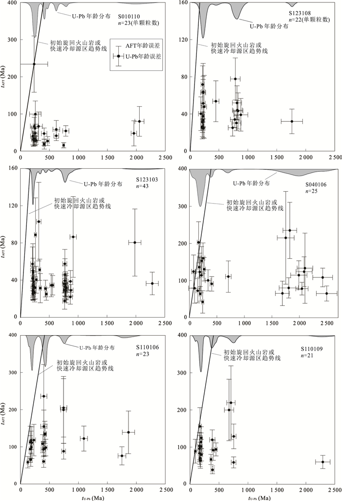
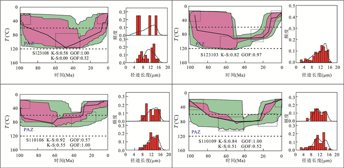
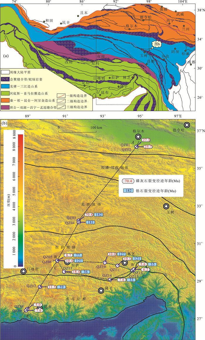
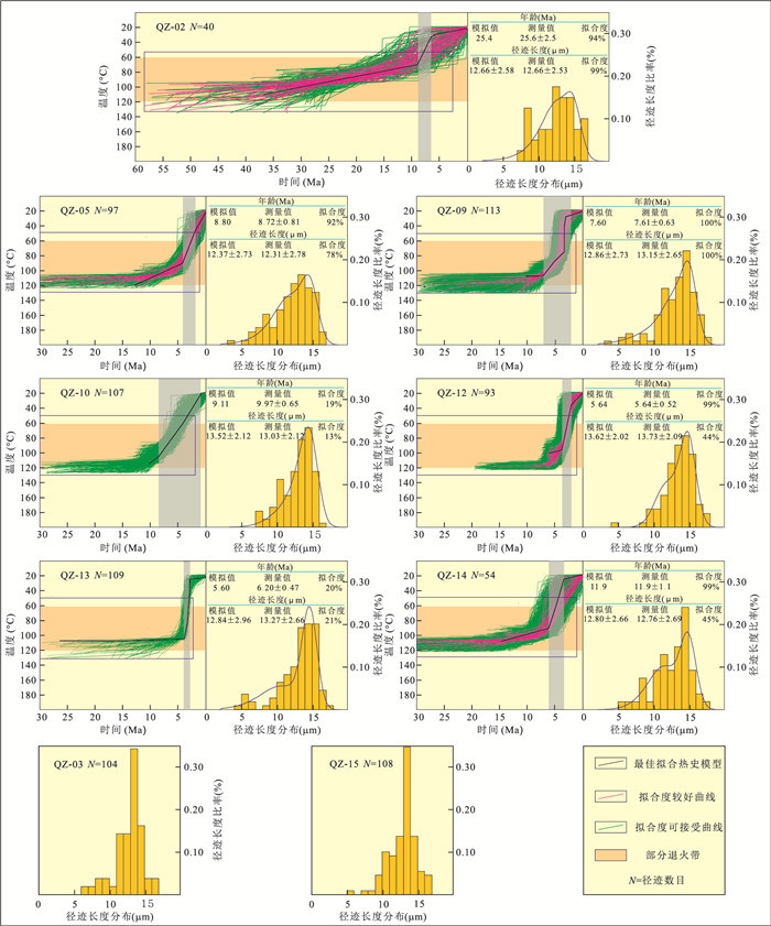
The spatial and temporal characteristics of the uplift in the Qinghai-Tibet Plateau since the Cenozoic has long been debated. Medium-and low-temperature thermochronological analysis on the base rocks plays an important role in detecting the uplifting processes of the plateau. Here we collected 15 intermediate-acid and metamorphic rock samples distributed in the Tibetan Plateau. Zircon and apatite fission track (ZFT and AFT) analyses were performed on these samples in order to provide constraints on the uplifting process of the plateau since the Mesozoic. 10 samples' ZFT results show that the ZFT ages range from 182 Ma to 33 Ma, probably recording collisions among different terranes or tectonothermal events in the Tibetan plateau before the Oligocene. Specially, ZFT ages of 3 samples distributed around the Yarlung Zangbo suture zone range from Late Eocene to Early Oligocene, which implies that a hard continent-continent collision occurred during ca. 36 to ca. 33 Ma. The Neocene ages dominate the AFT results, varying from 70.4 Ma to 5.0 Ma. Combined with the AFT reversed modeling results, it is concluded that southern part of Qinghai-Tibet Plateau has apparently experienced uplift since the Middle-Late Miocene. The uplift rates increased rapidly after ca. 5 Ma to ca. 4 Ma. The AFT ages become younger towards southeastern part of the Qinghai-Tibetan Plateau, implying the India and Asia continent collision controls the uplifting process of the Tibetan Plateau. Additionally, the central part of the plateau might have reached high altitude in the Late Cretaceous-Eocene and have kept very low denudation rate up to now.
The spatial and temporal characteristics of the uplift in the Qinghai-Tibet Plateau since the Cenozoic has long been debated. Medium-and low-temperature thermochronological analysis on the base rocks plays an important role in detecting the uplifting processes of the plateau. Here we collected 15 intermediate-acid and metamorphic rock samples distributed in the Tibetan Plateau. Zircon and apatite fission track (ZFT and AFT) analyses were performed on these samples in order to provide constraints on the uplifting process of the plateau since the Mesozoic. 10 samples' ZFT results show that the ZFT ages range from 182 Ma to 33 Ma, probably recording collisions among different terranes or tectonothermal events in the Tibetan plateau before the Oligocene. Specially, ZFT ages of 3 samples distributed around the Yarlung Zangbo suture zone range from Late Eocene to Early Oligocene, which implies that a hard continent-continent collision occurred during ca. 36 to ca. 33 Ma. The Neocene ages dominate the AFT results, varying from 70.4 Ma to 5.0 Ma. Combined with the AFT reversed modeling results, it is concluded that southern part of Qinghai-Tibet Plateau has apparently experienced uplift since the Middle-Late Miocene. The uplift rates increased rapidly after ca. 5 Ma to ca. 4 Ma. The AFT ages become younger towards southeastern part of the Qinghai-Tibetan Plateau, implying the India and Asia continent collision controls the uplifting process of the Tibetan Plateau. Additionally, the central part of the plateau might have reached high altitude in the Late Cretaceous-Eocene and have kept very low denudation rate up to now.


2018, 43(6): 1921-1930.
doi: 10.3799/dqkx.2018.602
Abstract:
Significant tectonic uplift and denudation occurred in central uplift of the South Yellow Sea basin (SYSB) since Late Cretaceous. Based on the drilling cores of CSDP-2 well which is supported and carried out by the Continental Scientific Drilling Project (CSDP) of China Geological Survey (CGS), the denudation and related characteristics of thermal history since Late Cretaceous in central uplift of SYSB were analyzed by apatite fission track (AFT) technique. The eight AFT ages obtained show two age groups, with one at (38±3) Ma, and the others ranging from (52±4) Ma to (65±5) Ma which all are much younger than the age of Permian where all samples locate, indicating that the samples were completely annealed and recorded the thermal history since Late Cretaceous. Modeling results of thermal history show that the peak paleo-geotemperature calculated by testing data of vitrinite reflectance (Ro) is within the range of the temperature interval of annealing zone of AFT. All samples suffered continuous cooling processes from the early stage of Late Cretaceous (ca.100 Ma) and started to enter into partial annealing zone (PAZ) at about 80-75 Ma. The first rapid cooling process began at the end of Late Cretaceous, and continued to the Early Paleocene, then was followed by a stage of slow cooling process during Paleogene. Some samples show the other rapid cooling process which is weaker than the first that occurred from the Late Oligocene to Early Miocene. The AFT ages and modeling results of thermal history significantly show the denudation and related characteristics since Late Cretaceous in central uplift of SYSB.
Significant tectonic uplift and denudation occurred in central uplift of the South Yellow Sea basin (SYSB) since Late Cretaceous. Based on the drilling cores of CSDP-2 well which is supported and carried out by the Continental Scientific Drilling Project (CSDP) of China Geological Survey (CGS), the denudation and related characteristics of thermal history since Late Cretaceous in central uplift of SYSB were analyzed by apatite fission track (AFT) technique. The eight AFT ages obtained show two age groups, with one at (38±3) Ma, and the others ranging from (52±4) Ma to (65±5) Ma which all are much younger than the age of Permian where all samples locate, indicating that the samples were completely annealed and recorded the thermal history since Late Cretaceous. Modeling results of thermal history show that the peak paleo-geotemperature calculated by testing data of vitrinite reflectance (Ro) is within the range of the temperature interval of annealing zone of AFT. All samples suffered continuous cooling processes from the early stage of Late Cretaceous (ca.100 Ma) and started to enter into partial annealing zone (PAZ) at about 80-75 Ma. The first rapid cooling process began at the end of Late Cretaceous, and continued to the Early Paleocene, then was followed by a stage of slow cooling process during Paleogene. Some samples show the other rapid cooling process which is weaker than the first that occurred from the Late Oligocene to Early Miocene. The AFT ages and modeling results of thermal history significantly show the denudation and related characteristics since Late Cretaceous in central uplift of SYSB.


2018, 43(6): 1931-1940.
doi: 10.3799/dqkx.2018.510
Abstract:
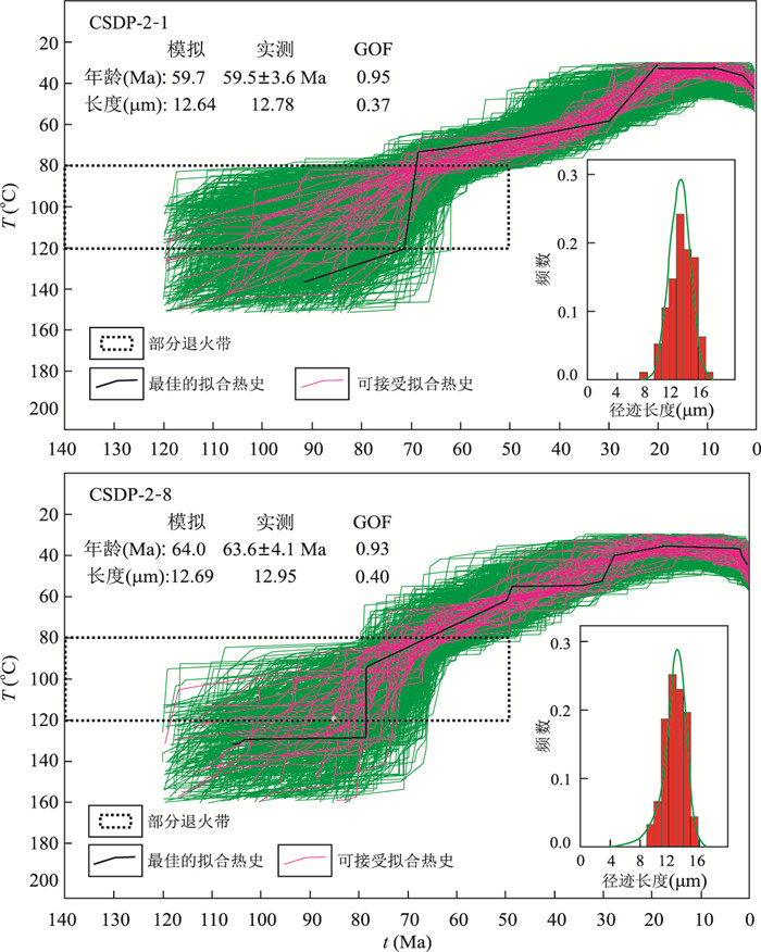
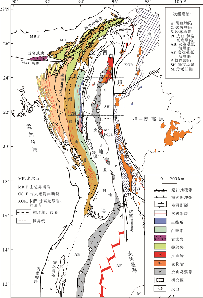
Study of the Cenozoic uplift of the northern Central Myanmar basin is crucial to better understand both the evolution of the West Burma block and the petroleum exploration in this area. Apatite fission track dating and thermal history modeling were carried out on two detrital samples and one core bedrock sample in this study. Our results show decreasing apatite fission track (AFT) ages in western thrust belt and eastern margin of the Chindwin subbasin to the magmatic arc belt of Myanmar (i.e., 70.6±9.3 Ma, 53.4±7.5 Ma and 22.7±3.0 Ma), indicating a progressive deformation of the northern Central Myanmar basin from west to east. Furthermore, the thermal modeling results indicate that in the Late Cretaceous (80±1 Ma) uplift process of the northern Central Myanmar basin can be divided into four stages:uplifting, rapid uplifting, steady uplifting, and slow uplifting. The rapid uplift and cooling event at the 29-20 Ma represents the regional uplift and exhumation in the northern Central Myanmar basin, followed by the slow uplift of the basin since 4 Ma, which is interpreted as the result of eastward movement and intense collision of the Indian plate with respect to the Asian plate. Our study suggests that the Cenozoic development and progressive deformation of the northern Central Myanmar basin was the direct result of multi-phase subduction of the Neo-Tethyan/Indian lithosphere to the West Burma block.
Study of the Cenozoic uplift of the northern Central Myanmar basin is crucial to better understand both the evolution of the West Burma block and the petroleum exploration in this area. Apatite fission track dating and thermal history modeling were carried out on two detrital samples and one core bedrock sample in this study. Our results show decreasing apatite fission track (AFT) ages in western thrust belt and eastern margin of the Chindwin subbasin to the magmatic arc belt of Myanmar (i.e., 70.6±9.3 Ma, 53.4±7.5 Ma and 22.7±3.0 Ma), indicating a progressive deformation of the northern Central Myanmar basin from west to east. Furthermore, the thermal modeling results indicate that in the Late Cretaceous (80±1 Ma) uplift process of the northern Central Myanmar basin can be divided into four stages:uplifting, rapid uplifting, steady uplifting, and slow uplifting. The rapid uplift and cooling event at the 29-20 Ma represents the regional uplift and exhumation in the northern Central Myanmar basin, followed by the slow uplift of the basin since 4 Ma, which is interpreted as the result of eastward movement and intense collision of the Indian plate with respect to the Asian plate. Our study suggests that the Cenozoic development and progressive deformation of the northern Central Myanmar basin was the direct result of multi-phase subduction of the Neo-Tethyan/Indian lithosphere to the West Burma block.


2018, 43(6): 1941-1956.
doi: 10.3799/dqkx.2018.527
Abstract:
The Lower Cretaceous of the Hari sag in the Yin'e basin has a unique sedimentary structure and mineral composition. The cause, sedimentary environment and formation pattern of the hydrothermal sediment of Lower Cretaceous in Hari depression, Yin'e basin are discussed in this study, based on its mineralogy, petrology and geochemistry. The Lower Cretaceous in Hari depression with lots of minerals including ganalcites, siderite and dolomite, is rich in Fe, Mn and Ba, characterized by high content of ∑REE, enrichment of LREE, and the negative Eu anomaly. Combined with Fe vs. Mn vs. (Cu+Co+Ni)×10 and Ni vs. Co vs. Zn ternary diagrams, it is proved that the Lower Cretaceous received long-term hydrothermal input during deposition. Analyses of trace elements, carbon and oxygen isotopes indicate the anoxic, closed, salty and lacustrine depositional environment. The formation temperatures of carbonate calculated by oxygen isotopes range from 43.94 ℃ to 86.08 ℃. It is concluded that complex faulting system provides the access to the lake water infiltrating down and the hydrothermal fluids upwelling. Moreover, convection activities between the hydrothermal fluids and the lake water continually offer heat and mineral elements to the lake. This type of hydrothermal sedimentation is long enduring and wide ranging, controlled by both terrigenous detrital materials supply and hydrothermal fluid property, which represents a special sedimentary model.
The Lower Cretaceous of the Hari sag in the Yin'e basin has a unique sedimentary structure and mineral composition. The cause, sedimentary environment and formation pattern of the hydrothermal sediment of Lower Cretaceous in Hari depression, Yin'e basin are discussed in this study, based on its mineralogy, petrology and geochemistry. The Lower Cretaceous in Hari depression with lots of minerals including ganalcites, siderite and dolomite, is rich in Fe, Mn and Ba, characterized by high content of ∑REE, enrichment of LREE, and the negative Eu anomaly. Combined with Fe vs. Mn vs. (Cu+Co+Ni)×10 and Ni vs. Co vs. Zn ternary diagrams, it is proved that the Lower Cretaceous received long-term hydrothermal input during deposition. Analyses of trace elements, carbon and oxygen isotopes indicate the anoxic, closed, salty and lacustrine depositional environment. The formation temperatures of carbonate calculated by oxygen isotopes range from 43.94 ℃ to 86.08 ℃. It is concluded that complex faulting system provides the access to the lake water infiltrating down and the hydrothermal fluids upwelling. Moreover, convection activities between the hydrothermal fluids and the lake water continually offer heat and mineral elements to the lake. This type of hydrothermal sedimentation is long enduring and wide ranging, controlled by both terrigenous detrital materials supply and hydrothermal fluid property, which represents a special sedimentary model.


2018, 43(6): 1957-1971.
doi: 10.3799/dqkx.2018.594
Abstract:
Suhongtu depression, located in the northeastern of Yin'e basin (Yingen-Ejinaqi basin), is a Mesozoic faulting-subsiding basin with large oil and gas resources. 75 vitrinite reflectance data from 7 wells in the study area are used to analyze the degree of thermal evolution of Mesozoic source rocks. The thermal evolution degree of source rocks in Yingen Formation is in immature to low mature stage. The vitrinite reflectance (Ro) data distribute in 0.6%-1.2% at the bottom of Suhongtu Formation, and they are generally greater than 1.1% at the bottom of Bayingebi Formation in the center of the sag. The results of Mesozoic and Cenozoic thermal history show that the present-day geothermal gradient is 34 ℃/km, and approximately 40.6-46.7 ℃/km in Late Cretaceous. The temperature gradient was 40-42 ℃/km (135-110 Ma) and increased to 46-50 ℃/km (110-103 Ma). Especially, during the deposition period of Yingen Formation (100-95 Ma), the geothermal gradient reached the maximum at about 48-53 ℃/km. From the beginning of Wulansuhai Formation, the geothermal gradient gradually increased to 40-46 ℃/km (92-80 Ma) and decreased to a present-day value of 34 ℃/km (80-0 Ma) ultimately. The higher geothermal field has played an important role in controlling oil and gas generation and accumulation since the Early Cretaceous, and the source rocks have reached the maximum thermal evolution stage at the end of the sedimentary period of the Wulansuhai Formation.
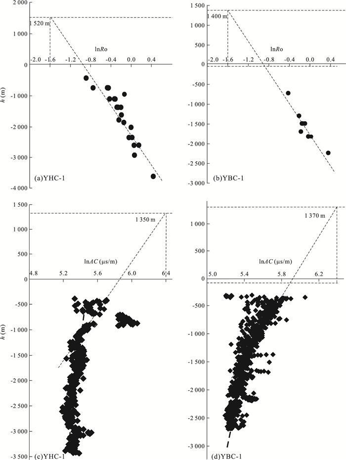
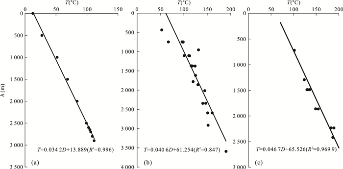
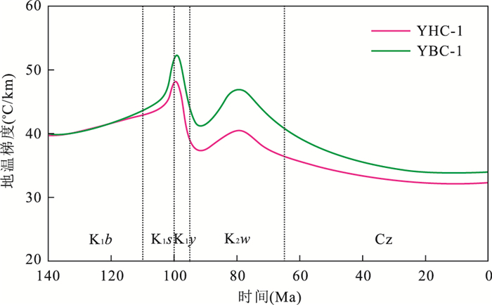
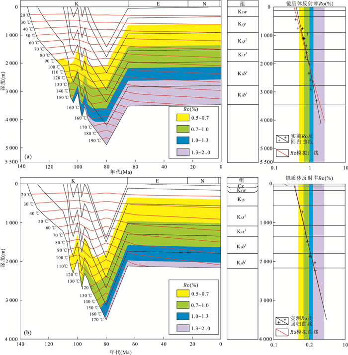
Suhongtu depression, located in the northeastern of Yin'e basin (Yingen-Ejinaqi basin), is a Mesozoic faulting-subsiding basin with large oil and gas resources. 75 vitrinite reflectance data from 7 wells in the study area are used to analyze the degree of thermal evolution of Mesozoic source rocks. The thermal evolution degree of source rocks in Yingen Formation is in immature to low mature stage. The vitrinite reflectance (Ro) data distribute in 0.6%-1.2% at the bottom of Suhongtu Formation, and they are generally greater than 1.1% at the bottom of Bayingebi Formation in the center of the sag. The results of Mesozoic and Cenozoic thermal history show that the present-day geothermal gradient is 34 ℃/km, and approximately 40.6-46.7 ℃/km in Late Cretaceous. The temperature gradient was 40-42 ℃/km (135-110 Ma) and increased to 46-50 ℃/km (110-103 Ma). Especially, during the deposition period of Yingen Formation (100-95 Ma), the geothermal gradient reached the maximum at about 48-53 ℃/km. From the beginning of Wulansuhai Formation, the geothermal gradient gradually increased to 40-46 ℃/km (92-80 Ma) and decreased to a present-day value of 34 ℃/km (80-0 Ma) ultimately. The higher geothermal field has played an important role in controlling oil and gas generation and accumulation since the Early Cretaceous, and the source rocks have reached the maximum thermal evolution stage at the end of the sedimentary period of the Wulansuhai Formation.


2018, 43(6): 1972-1982.
doi: 10.3799/dqkx.2018.562
Abstract:
The Fangshan pluton is located on the northern margin of the North China craton, and its uplift-exhumation and tectonothermal evolution in Mesozoic and Cenozoic can provide evidence for tectonic evolution of the North China craton. The tectonothermal history of the Fangshan pluton is reconstructed by the zircon fission track, apatite (U-Th)/He and zircon (U-Th)/He structural thermochronology based on the high-, middle-and low-temperature geochronological data in this paper. According to the relationship between the temperature difference (ΔT) and the cooling age difference (Δt) of different minerals, in this paper it calculates the cooling rate at different stages of thermal history and analyzes the characteristics of the cooling rate changes and the characteristics of uplift process of the Fangshan pluton based on previous research results. The results reveal four phases of tectonothermal history of the Fangshan pluton:(1) the crystallization and consolidation stage of emplaced magma during 130.0-123.5 Ma at the average cooling rate of 88.46 ℃/Ma; (2) the first slow cooling stage of the Fangshan pluton during 123.5-56.0 Ma at the average cooling rate of 0.74 ℃/Ma and the average uplift rate of 29.6 m/Ma; (3) the fast cooling stage of the Fangshan pluton during 56-35 Ma at the average cooling rate of 6.90 ℃/Ma and the average uplift rate of 276.0 m/Ma; (4)the second slow cooling stage of the Fangshan pluton since 35 Ma at the average cooling rate of 1.0 ℃/Ma and the average uplift rate of 40.0 m/Ma. The tectonic activity tends to be stable. The possible dynamic causes of thermal history of the Fangshan pluton were analyzed considering regional tectonic dynamics. The differential uplift-cooling may be associated with the subduction of the eastern Pacific plate of the North China craton, the intracontinental subduction orogeny on both sides of the south and the north, India-Eurasia collision in the southwestern China and the tectonic uplift of the Qinghai-Tibet plateau. The formation and the fast cooling stage of the Fangshan pluton respectively correspond to two important uplift erosion processes in the North China craton.
The Fangshan pluton is located on the northern margin of the North China craton, and its uplift-exhumation and tectonothermal evolution in Mesozoic and Cenozoic can provide evidence for tectonic evolution of the North China craton. The tectonothermal history of the Fangshan pluton is reconstructed by the zircon fission track, apatite (U-Th)/He and zircon (U-Th)/He structural thermochronology based on the high-, middle-and low-temperature geochronological data in this paper. According to the relationship between the temperature difference (ΔT) and the cooling age difference (Δt) of different minerals, in this paper it calculates the cooling rate at different stages of thermal history and analyzes the characteristics of the cooling rate changes and the characteristics of uplift process of the Fangshan pluton based on previous research results. The results reveal four phases of tectonothermal history of the Fangshan pluton:(1) the crystallization and consolidation stage of emplaced magma during 130.0-123.5 Ma at the average cooling rate of 88.46 ℃/Ma; (2) the first slow cooling stage of the Fangshan pluton during 123.5-56.0 Ma at the average cooling rate of 0.74 ℃/Ma and the average uplift rate of 29.6 m/Ma; (3) the fast cooling stage of the Fangshan pluton during 56-35 Ma at the average cooling rate of 6.90 ℃/Ma and the average uplift rate of 276.0 m/Ma; (4)the second slow cooling stage of the Fangshan pluton since 35 Ma at the average cooling rate of 1.0 ℃/Ma and the average uplift rate of 40.0 m/Ma. The tectonic activity tends to be stable. The possible dynamic causes of thermal history of the Fangshan pluton were analyzed considering regional tectonic dynamics. The differential uplift-cooling may be associated with the subduction of the eastern Pacific plate of the North China craton, the intracontinental subduction orogeny on both sides of the south and the north, India-Eurasia collision in the southwestern China and the tectonic uplift of the Qinghai-Tibet plateau. The formation and the fast cooling stage of the Fangshan pluton respectively correspond to two important uplift erosion processes in the North China craton.


2018, 43(6): 1983-1996.
doi: 10.3799/dqkx.2018.608
Abstract:
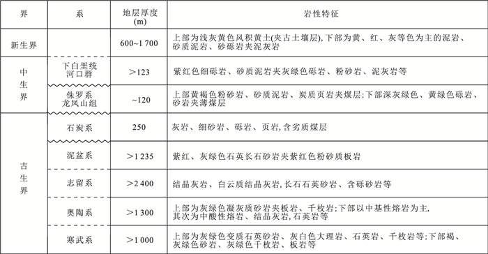
The northeastern margin of the Qilian Mountain, which is the outer zone of the uplift and eastward expansion of Tibetan plateau, has undergone a rapid uplift and strong exhumation process since the Cenozoic. The Mesozoic tectonic evolution study remains very weak for without the chronological constraints because pre-Cenozoic strata in the area have been subjected to the later alteration. Based on the analysis of source of the clastic rocks, sedimentary characteristics and basement apatite fission track dating, this paper reveals the Mesozoic tectonic uplift timing and process of the eastern Qilian Mountains with inversion simulation of fission track thermal history, aims at further exploration of the Mesozoic intracontinental tectonic evolution and regional dynamic background in the Qin-Qi orogenic belt. The results show that the Longfengshan Formation is the rift basin sediment of near-source accumulation from the pre-Mesozoic strata. The detrital apatite fission track has not been annealed, and it still retains the history of uplift and erosion in its source area. The fission track age and the thermal history simulation show that the rapid cooling event occurred in Late Triassic (±215 Ma) in source area, which has also been recorded by thermal history simulation results of the northestern granite body. Our results show the same time-space characteristics with the rapid uplift of the West Qinling region previously revealed by 40Ar/39Ar chronology. Apatite fission track dating reveals a rapid uplift event of the study area in the Late Triassic-Early Jurassic. It is believed that the tectonic uplift event may have been a response to the closure of Mianlue Ocean and consequent collision orogeny in the Middle to Late Triassic.
The northeastern margin of the Qilian Mountain, which is the outer zone of the uplift and eastward expansion of Tibetan plateau, has undergone a rapid uplift and strong exhumation process since the Cenozoic. The Mesozoic tectonic evolution study remains very weak for without the chronological constraints because pre-Cenozoic strata in the area have been subjected to the later alteration. Based on the analysis of source of the clastic rocks, sedimentary characteristics and basement apatite fission track dating, this paper reveals the Mesozoic tectonic uplift timing and process of the eastern Qilian Mountains with inversion simulation of fission track thermal history, aims at further exploration of the Mesozoic intracontinental tectonic evolution and regional dynamic background in the Qin-Qi orogenic belt. The results show that the Longfengshan Formation is the rift basin sediment of near-source accumulation from the pre-Mesozoic strata. The detrital apatite fission track has not been annealed, and it still retains the history of uplift and erosion in its source area. The fission track age and the thermal history simulation show that the rapid cooling event occurred in Late Triassic (±215 Ma) in source area, which has also been recorded by thermal history simulation results of the northestern granite body. Our results show the same time-space characteristics with the rapid uplift of the West Qinling region previously revealed by 40Ar/39Ar chronology. Apatite fission track dating reveals a rapid uplift event of the study area in the Late Triassic-Early Jurassic. It is believed that the tectonic uplift event may have been a response to the closure of Mianlue Ocean and consequent collision orogeny in the Middle to Late Triassic.


2018, 43(6): 1997-2006.
doi: 10.3799/dqkx.2018.607
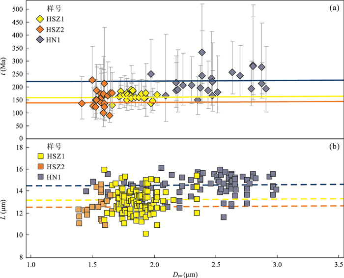
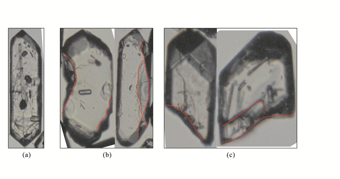
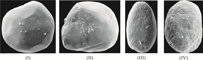
Abstract:
The geological thermochronology of detrital zircon in sediments is one of the most robust methods for the provenance analysis by providing accurate age constraint and tectonic setting of source terranes.However, the detrital zircon grains are often derived from more than one source terrane and have undergone a rather complicated terrestrial transportation processes from source to sink.The reconstruction of the surface dynamic processes from the source area to the catchment basin is critical to convincing geological interpretation of the detrital zircon U-Pb age patterns.This paper presents a new approach for the quantitative classification of detrital zircon morphologies, by quantifing various morphological parameters, including the mother rock of detrital zircon, the degree of crystal roundness, the way of crystal fracture, the degree of crystal fissure and the collision marks upon the crystal surfaces.In order to illustrate all the morphological parameters and make a reliable geological interpretation, we designed a new kind and teaching-friendly density plot, the multidimensional spider density plot, which could reveal the overall trend of one detrital zircon sample during the whole surface transportation process.Finally, detrital zircon samples, which were collected from the Cretaceous Continental Scientific Drilling borehole (CCSD-SK-1) in the Songliao basin, were analyzed to detect the provenance variation.The practical application proves that the morphological classification proposed in this paper is valid and reliable for provenance study.
The geological thermochronology of detrital zircon in sediments is one of the most robust methods for the provenance analysis by providing accurate age constraint and tectonic setting of source terranes.However, the detrital zircon grains are often derived from more than one source terrane and have undergone a rather complicated terrestrial transportation processes from source to sink.The reconstruction of the surface dynamic processes from the source area to the catchment basin is critical to convincing geological interpretation of the detrital zircon U-Pb age patterns.This paper presents a new approach for the quantitative classification of detrital zircon morphologies, by quantifing various morphological parameters, including the mother rock of detrital zircon, the degree of crystal roundness, the way of crystal fracture, the degree of crystal fissure and the collision marks upon the crystal surfaces.In order to illustrate all the morphological parameters and make a reliable geological interpretation, we designed a new kind and teaching-friendly density plot, the multidimensional spider density plot, which could reveal the overall trend of one detrital zircon sample during the whole surface transportation process.Finally, detrital zircon samples, which were collected from the Cretaceous Continental Scientific Drilling borehole (CCSD-SK-1) in the Songliao basin, were analyzed to detect the provenance variation.The practical application proves that the morphological classification proposed in this paper is valid and reliable for provenance study.


2018, 43(6): 2007-2018.
doi: 10.3799/dqkx.2018.611
Abstract:
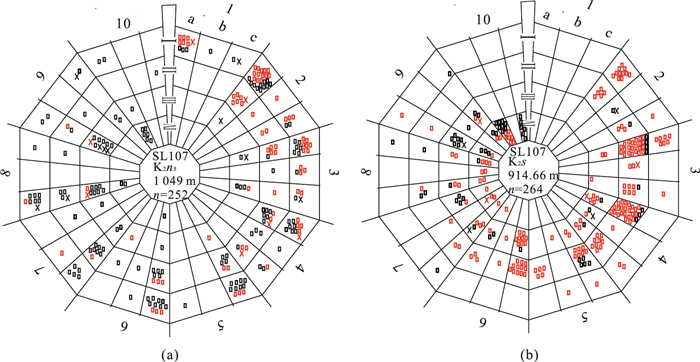
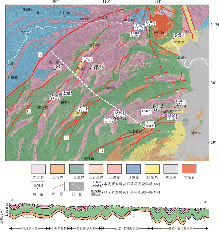
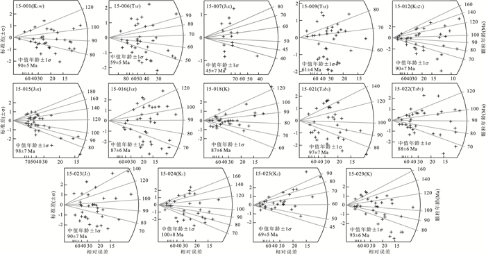
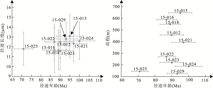
Reconstruction of the Mesozoic-Cenozoic exhumation history in western Hunan-Hubei fold belt and establishing its temporal and spatial evolution play important role in the research of intracontinental orogeny as well as the petroleum exploration in this area.Based on apatite fission track (AFT) analysis and time-temperature thermal history modeling results, this work quantitively constrains the exhumation rate and thickness of the western Hunan-Hubei fold belt.The AFT ages here range from 71 to 100 Ma.Integrating with the AFT ages from fold belt in the East Sichuan basin, all the data present a younger trend from southeast to northwest.The time-temperature thermal history since Mesozoic shows a "three-stages" feature with the turning period occurred at 115-90 Ma and 35-20 Ma.The three stages correspond well with the geological evidence and respectively indicate different deformations.The deformations are respectively orogeny during Late Jurassic-Early Cretaceous, basin formation in Late Cretaceous and tectonic uplift since Cenozoic.Yanshannian event is the main cause of the deformation.The deformation occurred earlier in the southeast and later in the northwest and the exhumation also presented a pattern being stronger in the southeast and weaker in the northwest.All the recognization during this work provides strong evidences for the deformation and evolution process of the western Hunan-Hubei to East Sichuan fold belt.
Reconstruction of the Mesozoic-Cenozoic exhumation history in western Hunan-Hubei fold belt and establishing its temporal and spatial evolution play important role in the research of intracontinental orogeny as well as the petroleum exploration in this area.Based on apatite fission track (AFT) analysis and time-temperature thermal history modeling results, this work quantitively constrains the exhumation rate and thickness of the western Hunan-Hubei fold belt.The AFT ages here range from 71 to 100 Ma.Integrating with the AFT ages from fold belt in the East Sichuan basin, all the data present a younger trend from southeast to northwest.The time-temperature thermal history since Mesozoic shows a "three-stages" feature with the turning period occurred at 115-90 Ma and 35-20 Ma.The three stages correspond well with the geological evidence and respectively indicate different deformations.The deformations are respectively orogeny during Late Jurassic-Early Cretaceous, basin formation in Late Cretaceous and tectonic uplift since Cenozoic.Yanshannian event is the main cause of the deformation.The deformation occurred earlier in the southeast and later in the northwest and the exhumation also presented a pattern being stronger in the southeast and weaker in the northwest.All the recognization during this work provides strong evidences for the deformation and evolution process of the western Hunan-Hubei to East Sichuan fold belt.

2018, 43(6): 2019-2028.
doi: 10.3799/dqkx.2018.598
Abstract:
We present the tectonic evolution characteristics of Yemaquan area, which is located in west of the East Kunlun Mountains, according to apatite fission track thermochronology analysis.The results show that apatite fission track ages mainly are divided into three groups, including 153.8 Ma, 106.8 to 81.0 Ma, and 48.7 to 44.4 Ma, respectively.The Bangonghu-Nujiang ocean closure event happened in 153.8 Ma, then the collision and combination of Lhasa block and Qiangtang block on the East Kunlun area mainly ranged from 106.8 to 81.0 Ma, and post-orogenic stretching events after the collision between the India-Eurasia occurred during 48.7 Ma and 44.4 Ma.In addition, the analysis results also indicate that three stages of thermal history of Yemaquan area are mainly ranged from 130 to 110 Ma, 110 to 14 Ma, and 14 Ma to now, respectively.The first stage, 130-110 Ma, corresponds to collision activity between the Lhasa and the Qiangtang block after the closed up of the Bangonghu-Nujiang oceanic basin.The second stage, 110-14 Ma, rised continuously, with strike-slip movement of Alkin fault and the ductile deformation of the Xidatan fault occurred during 110-90 Ma.And the last stage, 14 Ma to now, uplifted rapidly, and affected by strong tectonic activity of Tibetan plateau since Neogene.Uplift rates and uplift ranges for these three stages are estimated of 0.021 mm/a and 0.42 km, 0.01 mm/a and 1.0 km, and 0.1 mm/a and 1.43 km, respectively, with the average uplift rate and the total uplift height of 0.028 mm/a, and 2.86 km, respectively.
We present the tectonic evolution characteristics of Yemaquan area, which is located in west of the East Kunlun Mountains, according to apatite fission track thermochronology analysis.The results show that apatite fission track ages mainly are divided into three groups, including 153.8 Ma, 106.8 to 81.0 Ma, and 48.7 to 44.4 Ma, respectively.The Bangonghu-Nujiang ocean closure event happened in 153.8 Ma, then the collision and combination of Lhasa block and Qiangtang block on the East Kunlun area mainly ranged from 106.8 to 81.0 Ma, and post-orogenic stretching events after the collision between the India-Eurasia occurred during 48.7 Ma and 44.4 Ma.In addition, the analysis results also indicate that three stages of thermal history of Yemaquan area are mainly ranged from 130 to 110 Ma, 110 to 14 Ma, and 14 Ma to now, respectively.The first stage, 130-110 Ma, corresponds to collision activity between the Lhasa and the Qiangtang block after the closed up of the Bangonghu-Nujiang oceanic basin.The second stage, 110-14 Ma, rised continuously, with strike-slip movement of Alkin fault and the ductile deformation of the Xidatan fault occurred during 110-90 Ma.And the last stage, 14 Ma to now, uplifted rapidly, and affected by strong tectonic activity of Tibetan plateau since Neogene.Uplift rates and uplift ranges for these three stages are estimated of 0.021 mm/a and 0.42 km, 0.01 mm/a and 1.0 km, and 0.1 mm/a and 1.43 km, respectively, with the average uplift rate and the total uplift height of 0.028 mm/a, and 2.86 km, respectively.


2018, 43(6): 2029-2041.
doi: 10.3799/dqkx.2018.604
Abstract:
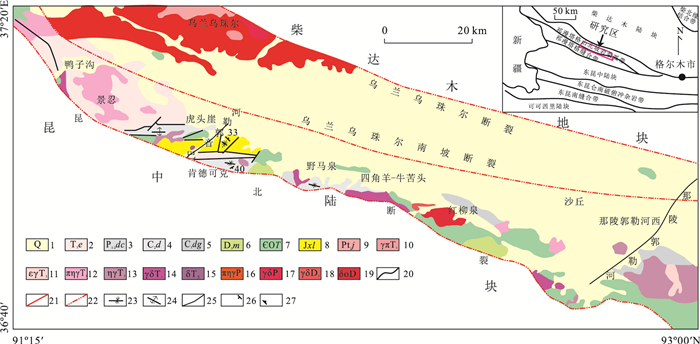
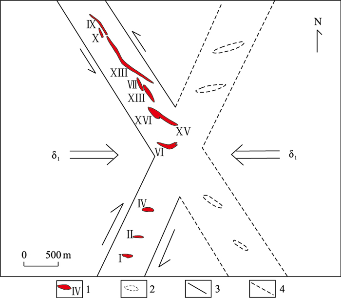
The Dangba pegmatite-type spodumene deposit, located in the southeast of Keeryin orefield, also in the eastern part of Songpan-Ganze rare metal ore-forming belt, is one of super-large spodumene deposits in Sichuan, China. In order to find out the ore-forming potential in the deep and periphery, combining with the previous research results and field geological observation, this paper summarizes the spatial variation characteristics of magmatic rock facies and the mechanical characteristics of rock controlling structures in mining area, deeply analyzes the metallogenic regularity, and proposed the direction of geological prospecting. It is concluded as follows:(1) The main vein Ⅷ in Dangba mining area is albite spodumene+lepidolite type pegmatite vein formed by two-stage mineralization of superposition and recombination. The pegmatite intrastructural zoning is obvious in each period, with the lepidolite albite pegmatite belt, the muscovite albite pegmatite belt, and the spodumene albite pegmatite zone distributed from the outside to the inside; (2) Being controlled by the NW-trending and NEE-trending structures, the mineralized pegmatite belts show a trend of "X" type distribution; (3) Being centered around the diagenetic mineralization, vein Ⅵ NW extensional veins pitch to southeast, and the NE extensional veins pitch to northeast. This study indicates the direction of the deep and peripheral geological prospecting for Dangba spodumene deposit.
The Dangba pegmatite-type spodumene deposit, located in the southeast of Keeryin orefield, also in the eastern part of Songpan-Ganze rare metal ore-forming belt, is one of super-large spodumene deposits in Sichuan, China. In order to find out the ore-forming potential in the deep and periphery, combining with the previous research results and field geological observation, this paper summarizes the spatial variation characteristics of magmatic rock facies and the mechanical characteristics of rock controlling structures in mining area, deeply analyzes the metallogenic regularity, and proposed the direction of geological prospecting. It is concluded as follows:(1) The main vein Ⅷ in Dangba mining area is albite spodumene+lepidolite type pegmatite vein formed by two-stage mineralization of superposition and recombination. The pegmatite intrastructural zoning is obvious in each period, with the lepidolite albite pegmatite belt, the muscovite albite pegmatite belt, and the spodumene albite pegmatite zone distributed from the outside to the inside; (2) Being controlled by the NW-trending and NEE-trending structures, the mineralized pegmatite belts show a trend of "X" type distribution; (3) Being centered around the diagenetic mineralization, vein Ⅵ NW extensional veins pitch to southeast, and the NE extensional veins pitch to northeast. This study indicates the direction of the deep and peripheral geological prospecting for Dangba spodumene deposit.


2018, 43(6): 2042-2054.
doi: 10.3799/dqkx.2018.595
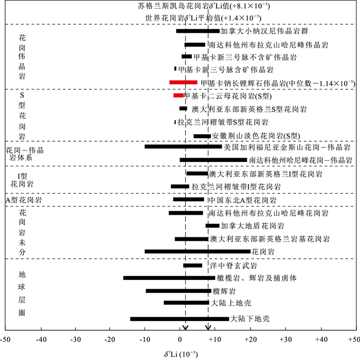
Abstract:
Jiajika superlarge hard rock type lithium deposit is one of the most abundant lithium mineral resouces in China. The two-mica granite outcropped in the southern Jiajika orefield is generally regarded as source rocks of the ore-bearing pegmatites. Li isotopic composition is a useful tool to explore the origin and evolution of rare metal. Based on the detailed field work, the lithium isotopic composition of granite was tested by MC-ICP-MS in this study. The results show that the lithium content of the granite is from 192×10-6 to 470×10-6, and the mean value is 309×10-6; the value of δ7Li ranges from -1.56‰ to 0.90‰, and the mean value is -0.24‰, which is closed to the average value of upper crust. Jiajika two-mica granite apparently has higher content of lithium and lower value of δ7Li, and the δ7Li and Li, Rb, Ga, SiO2 and εNd(t) have no obvious correlation. Lithium isotopic composition of granite reflects its characteristics of source rock, and it has not been influenced by crystallization differentiation of magma and alteration. The geochemical and isotope geochemistry data indicate that the source of magma is mainly composed of partial melting of Triassic Xikang sand-mudstone, which may have been mixed with materials from deep source. In addition, variations of lithium content and Li isotopic composition show that the fluid of magma migrated from center to the north and south, and the metallogenic fluid of pegmatite is derived from Jiajika two-mica granite. The content of lithium and Li isotopic composition can not only be used to classify the types of lithium deposits, but also can facilitate the prospecting of rare metals.
Jiajika superlarge hard rock type lithium deposit is one of the most abundant lithium mineral resouces in China. The two-mica granite outcropped in the southern Jiajika orefield is generally regarded as source rocks of the ore-bearing pegmatites. Li isotopic composition is a useful tool to explore the origin and evolution of rare metal. Based on the detailed field work, the lithium isotopic composition of granite was tested by MC-ICP-MS in this study. The results show that the lithium content of the granite is from 192×10-6 to 470×10-6, and the mean value is 309×10-6; the value of δ7Li ranges from -1.56‰ to 0.90‰, and the mean value is -0.24‰, which is closed to the average value of upper crust. Jiajika two-mica granite apparently has higher content of lithium and lower value of δ7Li, and the δ7Li and Li, Rb, Ga, SiO2 and εNd(t) have no obvious correlation. Lithium isotopic composition of granite reflects its characteristics of source rock, and it has not been influenced by crystallization differentiation of magma and alteration. The geochemical and isotope geochemistry data indicate that the source of magma is mainly composed of partial melting of Triassic Xikang sand-mudstone, which may have been mixed with materials from deep source. In addition, variations of lithium content and Li isotopic composition show that the fluid of magma migrated from center to the north and south, and the metallogenic fluid of pegmatite is derived from Jiajika two-mica granite. The content of lithium and Li isotopic composition can not only be used to classify the types of lithium deposits, but also can facilitate the prospecting of rare metals.


2018, 43(6): 2055-2075.
doi: 10.3799/dqkx.2018.613
Abstract:
Northeast China, located in the eastern part of the Central Asian orogenic belt (CAOB), is composed of several micro-blocks (e.g. Erguna block, Xing'an block, Songliao block and Jiamusi block). However the suturing locations, timing and the amalgamation processes among the micro-blocks are still unclear. This study focuses on the systematic study on petrography and detrital zircon LA-ICP-MS U-Pb ages of the Late Carboniferous to Early Permian sandstones from the Baoligaomiao Formation in the Moguqi area, Central Great Xing'an range, in order to reveal the tectonic background of the provenances and constrain the evolution history of the Xing'an and Songliao blocks. Petrographically, detrital compositions show that the investigated sandstones are immature, probably due to rapid erosion, transportation, and diagenetic processes, as well as nearly supplying from the source area. Additionally, the abundance of volcanic lithic reveals that the magmatic provenance dominates. Meanwhile, the cathodoluminescence (CL) images, Th/U ratios and REE pattern of analyzed zircons also imply the igneous origin. Zircon U-Pb ages obtained from the analyzed samples are mainly concentrated in 282-360 Ma (n=134), with the peaks at ca.290 Ma, 305 Ma, 325 Ma and 350 Ma. By combining our new geochronological data with previous regional reports, it is concluded that the provenance of the sandstones is possibly derived from the subduction-and syn-collision-related Paleozoic magmatic arc along the Moguqi-Nenjiang-Heihe areas. Furthermore, the youngest zircon U-Pb ages of 282±4 Ma (sample 15MG10) and 287±4 Ma (sample 15MG11) give the lower limit age of sediments. Comparing the detrital zircon U-Pb concentrations of the Late Carboniferous to Early Triassic sandstones in the Suolun-Moguqi areas, it is found that there is no difference between the Late Carboniferous to Early Permian clastic components in the Xing'an block and the Middle Permian to Early Triassic ones in the Songliao block, indicating the above mentioned two blocks have been amalgamated before Late Carboniferous period along the Hegenshan-Heihe suture zone.
Northeast China, located in the eastern part of the Central Asian orogenic belt (CAOB), is composed of several micro-blocks (e.g. Erguna block, Xing'an block, Songliao block and Jiamusi block). However the suturing locations, timing and the amalgamation processes among the micro-blocks are still unclear. This study focuses on the systematic study on petrography and detrital zircon LA-ICP-MS U-Pb ages of the Late Carboniferous to Early Permian sandstones from the Baoligaomiao Formation in the Moguqi area, Central Great Xing'an range, in order to reveal the tectonic background of the provenances and constrain the evolution history of the Xing'an and Songliao blocks. Petrographically, detrital compositions show that the investigated sandstones are immature, probably due to rapid erosion, transportation, and diagenetic processes, as well as nearly supplying from the source area. Additionally, the abundance of volcanic lithic reveals that the magmatic provenance dominates. Meanwhile, the cathodoluminescence (CL) images, Th/U ratios and REE pattern of analyzed zircons also imply the igneous origin. Zircon U-Pb ages obtained from the analyzed samples are mainly concentrated in 282-360 Ma (n=134), with the peaks at ca.290 Ma, 305 Ma, 325 Ma and 350 Ma. By combining our new geochronological data with previous regional reports, it is concluded that the provenance of the sandstones is possibly derived from the subduction-and syn-collision-related Paleozoic magmatic arc along the Moguqi-Nenjiang-Heihe areas. Furthermore, the youngest zircon U-Pb ages of 282±4 Ma (sample 15MG10) and 287±4 Ma (sample 15MG11) give the lower limit age of sediments. Comparing the detrital zircon U-Pb concentrations of the Late Carboniferous to Early Triassic sandstones in the Suolun-Moguqi areas, it is found that there is no difference between the Late Carboniferous to Early Permian clastic components in the Xing'an block and the Middle Permian to Early Triassic ones in the Songliao block, indicating the above mentioned two blocks have been amalgamated before Late Carboniferous period along the Hegenshan-Heihe suture zone.


2018, 43(6): 2076-2099.
doi: 10.3799/dqkx.2018.601
Abstract:
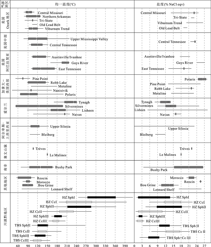
In order to constrain the source of the ore-forming fluids in large Pb-Zn deposits in the Sichuan-Yunnan-Guizhou region, fluid inclusions and He-Ar isotopes have been analyzed in ore-forming fluids trapped in sulphide minerals from the large Tianbaoshan Pb-Zn deposit and the super large Huize Pb-Zn deposit. The results are summarized as follows:(1) Fluid inclusions in Tianbaoshan deposit have medium-low homogenization temperatures and medium salinities, and ore-forming fluids are mainly derived from basin brine, whereas fluid inclusions in Huize deposit represent high-medium homogenization temperatures and medium salinities, and ore-forming fluids are dominantly derived from basin brine, but with evidence for mixing of different fluids. (2) The values of 3He/4He in Tianbaoshan deposit and Huize deposit range from 0.02 to 0.32 Ra (where Ra is the atmospheric value; 3He/4He=1.4×10-6), indicating that the ore-forming fluids are dominated by continental crust fluids, where as a small but clear mantle helium contribution is present. And the measurements of 40Ar/36Ar ratio (345.0-1 698.8) indicate that the ore-forming fluids mainly consist of saturated atmospheric water. (3) Combined with geological features, fluid inclusion trapped in sulphide minerals and He-Ar isotopes, it is concluded that the ore-forming processes of Tianbaoshan deposit and Huize deposit are related to the evolution of Youjiang sedimentary basin and the magmatic activities of the Emeishan large igneous province.
In order to constrain the source of the ore-forming fluids in large Pb-Zn deposits in the Sichuan-Yunnan-Guizhou region, fluid inclusions and He-Ar isotopes have been analyzed in ore-forming fluids trapped in sulphide minerals from the large Tianbaoshan Pb-Zn deposit and the super large Huize Pb-Zn deposit. The results are summarized as follows:(1) Fluid inclusions in Tianbaoshan deposit have medium-low homogenization temperatures and medium salinities, and ore-forming fluids are mainly derived from basin brine, whereas fluid inclusions in Huize deposit represent high-medium homogenization temperatures and medium salinities, and ore-forming fluids are dominantly derived from basin brine, but with evidence for mixing of different fluids. (2) The values of 3He/4He in Tianbaoshan deposit and Huize deposit range from 0.02 to 0.32 Ra (where Ra is the atmospheric value; 3He/4He=1.4×10-6), indicating that the ore-forming fluids are dominated by continental crust fluids, where as a small but clear mantle helium contribution is present. And the measurements of 40Ar/36Ar ratio (345.0-1 698.8) indicate that the ore-forming fluids mainly consist of saturated atmospheric water. (3) Combined with geological features, fluid inclusion trapped in sulphide minerals and He-Ar isotopes, it is concluded that the ore-forming processes of Tianbaoshan deposit and Huize deposit are related to the evolution of Youjiang sedimentary basin and the magmatic activities of the Emeishan large igneous province.


2018, 43(6): 2100-2115.
doi: 10.3799/dqkx.2018.548
Abstract:
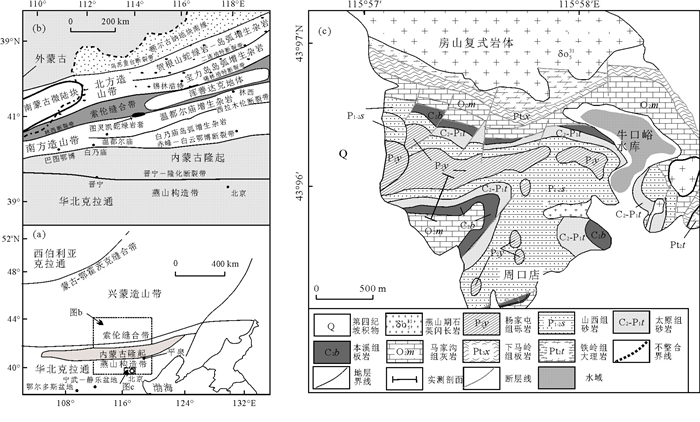
The Late Paleozoic siliciclastic rocks outcrop in the southern hillside of Taiping hill, Zhoukoudian area. In order to trace sediment provenance and unravel the tectonic evolution of the North China craton and its surrounding plates, U-Pb dating and Hf isotopic analyses were performed on detrital zircons from this succession. U-Pb ages of five samples can be divided into three groups:Phanerozoic (285-425 Ma), Paleoproterozoic (1 700-2 450 Ma) and Neoarchean (2 500-2 747 Ma). Precambrian zircons show obvious age peaks at 2.5 Ga and 1.8 Ga, which are similar to those of basement rocks of the North China Craton. Phanerozoic zircons from five samples are predominantly distributed in the range of 308-297 Ma, with the youngest peaks varying from 299 to 291 Ma. U-Pb ages of the youngest zircons are consistent with the Early Permian depositional age, suggesting that these zircons are synsedimentary detritus. Characteristics of age spectra of the Phanerozoic zircons are similar to those of coeval igneous rocks outcropped in the Inner Mongolia paleo-uplift to the north, which suggests the source of Phanerozoic zircons. The 176Hf/177Hf and εHf(t) values of 29 synsedimentary zircons range from 0.282 021 to 0.282 318 and -20.1 to -9.1, respectively, which are consistent with those of active arc rocks in the Inner Mongolia paleo-uplift, rather than the Xing-Meng orogenic belt. Minor detritus from the Early Paleozoic arc rocks in the southern orogen of the Xing-Meng orogen also flowed into the basin. Trace elements of Early Permian synsedimentary zircons are characterized by those of zircons crystallized in the environment of continent arc and active continental boundary. The results suggest that:(1) the northern margin of the North China craton was an Andean-type continental margin during the Late Carboniferous to Early Permian period, (2) rapid rise of the Inner Mongolia paleo-uplift was attributed to the subduction of Paleo-Asian ocean under the northern margin of the craton, and (3) closure of the Paleo-Asian ocean should be later than the Early Permian.
The Late Paleozoic siliciclastic rocks outcrop in the southern hillside of Taiping hill, Zhoukoudian area. In order to trace sediment provenance and unravel the tectonic evolution of the North China craton and its surrounding plates, U-Pb dating and Hf isotopic analyses were performed on detrital zircons from this succession. U-Pb ages of five samples can be divided into three groups:Phanerozoic (285-425 Ma), Paleoproterozoic (1 700-2 450 Ma) and Neoarchean (2 500-2 747 Ma). Precambrian zircons show obvious age peaks at 2.5 Ga and 1.8 Ga, which are similar to those of basement rocks of the North China Craton. Phanerozoic zircons from five samples are predominantly distributed in the range of 308-297 Ma, with the youngest peaks varying from 299 to 291 Ma. U-Pb ages of the youngest zircons are consistent with the Early Permian depositional age, suggesting that these zircons are synsedimentary detritus. Characteristics of age spectra of the Phanerozoic zircons are similar to those of coeval igneous rocks outcropped in the Inner Mongolia paleo-uplift to the north, which suggests the source of Phanerozoic zircons. The 176Hf/177Hf and εHf(t) values of 29 synsedimentary zircons range from 0.282 021 to 0.282 318 and -20.1 to -9.1, respectively, which are consistent with those of active arc rocks in the Inner Mongolia paleo-uplift, rather than the Xing-Meng orogenic belt. Minor detritus from the Early Paleozoic arc rocks in the southern orogen of the Xing-Meng orogen also flowed into the basin. Trace elements of Early Permian synsedimentary zircons are characterized by those of zircons crystallized in the environment of continent arc and active continental boundary. The results suggest that:(1) the northern margin of the North China craton was an Andean-type continental margin during the Late Carboniferous to Early Permian period, (2) rapid rise of the Inner Mongolia paleo-uplift was attributed to the subduction of Paleo-Asian ocean under the northern margin of the craton, and (3) closure of the Paleo-Asian ocean should be later than the Early Permian.


2018, 43(6): 2116-2132.
doi: 10.3799/dqkx.2018.551
Abstract:
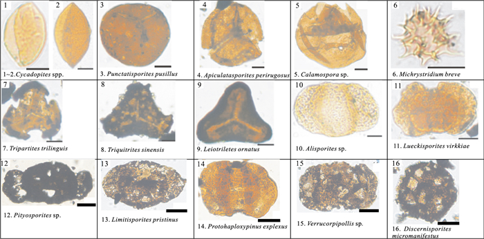
The study of the sedimentology and tectonic settings of the Paleotethys remnant oceanic basins is of great significance to reveal the formation, evolution, and its regularity of ore formation of the Tibetan plateau. The paleotethys remnant oceanic basin in Zexue district is located in the Lhasa block in south Gangdese zone. Based on the data such as field measured profiles, typical outcrops, rock sections, biostratigraphy and depo-geochemistry, we conducted the study on deep-water basin stratigraphy, sedimentology, sedimentary evolution and provenance tectonic settings of the Late Paleozoic paleotethys remnant oceanic basin. Current research indicates that the Late Paleozoic strata developed in the study area are mainly composed of pebbled fine clastic rocks and sandstone, which include pebbled-siltstone, mudstone and sandstone. The sand body is dominated by sheetlike and lenticular form, rich sedimentary structure, and the obvious Late Paleozoic sporo-pollen combination. The remnant oceanic basin experienced the evolutionary phases of sedimentary filling, which from continental slope-, deepwater basin-, continental shelf delta-, littoral-shallow basin-, coastal delta, to bay basin. The clastic sediment geochemical composition and their ratios of the main elements have characteristic of the lower Fe2O3+MgO (5.1%-10.0%), TiO2 (0.44%-0.84%), Al2O3/SiO2 (0.12-0.26), and higher K2O/Na2O. The results of the composition of trace and rare elements show higher ∑REE, LREE, La/Yb, (Gd/Yb)N, (La/Yb)N ratio, and weak Eu negative anomaly. It suggests that the provenance area has the characteristics of active continental margin and the continental island arc. It is concluded that the tectonic-sedimentary background of the Late Paleozoic in study area was in the continental margin rifting in extension background, intensive tectonic-magmatic activities and uplift, and the characteristic of more stable inheritance evolution. Sedimentary filling and evolution of the basin recorded the gradual regression process and the closure of the remnant oceanic basins in the Paleotethys.
The study of the sedimentology and tectonic settings of the Paleotethys remnant oceanic basins is of great significance to reveal the formation, evolution, and its regularity of ore formation of the Tibetan plateau. The paleotethys remnant oceanic basin in Zexue district is located in the Lhasa block in south Gangdese zone. Based on the data such as field measured profiles, typical outcrops, rock sections, biostratigraphy and depo-geochemistry, we conducted the study on deep-water basin stratigraphy, sedimentology, sedimentary evolution and provenance tectonic settings of the Late Paleozoic paleotethys remnant oceanic basin. Current research indicates that the Late Paleozoic strata developed in the study area are mainly composed of pebbled fine clastic rocks and sandstone, which include pebbled-siltstone, mudstone and sandstone. The sand body is dominated by sheetlike and lenticular form, rich sedimentary structure, and the obvious Late Paleozoic sporo-pollen combination. The remnant oceanic basin experienced the evolutionary phases of sedimentary filling, which from continental slope-, deepwater basin-, continental shelf delta-, littoral-shallow basin-, coastal delta, to bay basin. The clastic sediment geochemical composition and their ratios of the main elements have characteristic of the lower Fe2O3+MgO (5.1%-10.0%), TiO2 (0.44%-0.84%), Al2O3/SiO2 (0.12-0.26), and higher K2O/Na2O. The results of the composition of trace and rare elements show higher ∑REE, LREE, La/Yb, (Gd/Yb)N, (La/Yb)N ratio, and weak Eu negative anomaly. It suggests that the provenance area has the characteristics of active continental margin and the continental island arc. It is concluded that the tectonic-sedimentary background of the Late Paleozoic in study area was in the continental margin rifting in extension background, intensive tectonic-magmatic activities and uplift, and the characteristic of more stable inheritance evolution. Sedimentary filling and evolution of the basin recorded the gradual regression process and the closure of the remnant oceanic basins in the Paleotethys.


2018, 43(6): 2133-2148.
doi: 10.3799/dqkx.2017.619
Abstract:
The Southeast Sichuan area is one of important natural gas exploration areas in the southern China, and the distribution of gas reservoirs is closely related with the tectonic evolution of the fold belt, which shows horsetail-shaped planar pattern, with formation mechanism still in dispute. Analogue modeling is an effective method for the study of the structural formation mechanism. Based on the detailed analysis of the structural characteristics of the horsetail-shaped fold belt in this area, we designed five sets of models, considering four factors including boundary geometry, stratigraphic rheological structure, ductile layer viscosity and base friction coefficient, to conduct a systematic study on its formation mechanism. The results show that:(1)The formation of the horsetail-shaped fold belt is closely related to the shapes of Huayingshan fault and Qiyueshan boundary fault in the East Sichuan; (2)The ratio of brittle/ductile strata and thickness difference of the brittle layers have important controls on the wavelength and pattern of the folds; (3)The appropriate base friction is an important condition for the formation of the horsetail-shaped folds; (4) The difference of the basal rheological strength between the Sichuan basin, the East Sichuan and the West Hunan-Hubei may also have an important effect on the formation of the horsetail-shaped fold belt.
The Southeast Sichuan area is one of important natural gas exploration areas in the southern China, and the distribution of gas reservoirs is closely related with the tectonic evolution of the fold belt, which shows horsetail-shaped planar pattern, with formation mechanism still in dispute. Analogue modeling is an effective method for the study of the structural formation mechanism. Based on the detailed analysis of the structural characteristics of the horsetail-shaped fold belt in this area, we designed five sets of models, considering four factors including boundary geometry, stratigraphic rheological structure, ductile layer viscosity and base friction coefficient, to conduct a systematic study on its formation mechanism. The results show that:(1)The formation of the horsetail-shaped fold belt is closely related to the shapes of Huayingshan fault and Qiyueshan boundary fault in the East Sichuan; (2)The ratio of brittle/ductile strata and thickness difference of the brittle layers have important controls on the wavelength and pattern of the folds; (3)The appropriate base friction is an important condition for the formation of the horsetail-shaped folds; (4) The difference of the basal rheological strength between the Sichuan basin, the East Sichuan and the West Hunan-Hubei may also have an important effect on the formation of the horsetail-shaped fold belt.


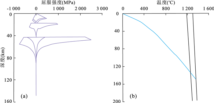
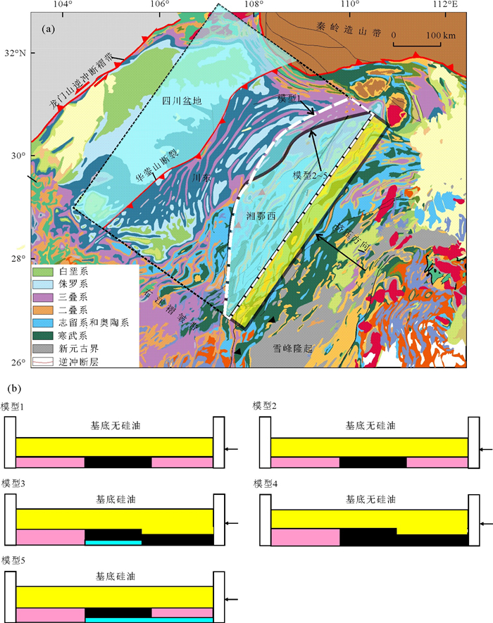


2018, 43(6): 2149-2159.
doi: 10.3799/dqkx.2018.568
Abstract:
The deep-water channel sedimentary type is one of important sedimentary types in the deep-water zone. Research on the mechanism of deep-water channel not only can improve acquaintance of deep-water deposits, but also is helpful to oil and gas exploration. Mechanism of the deep-water channel of the Ordovician Lashizhong Formation in western margin of the Ordos basin was detailedly worked based on outcrop. The lithology of Lashizhong Formation consists of greyish-green mudstone and sandstone and few siltstone and conglomeration with flute cast, cross bedding, graded bedding and deformation structure, which suggests deep-water environment. Gravity flow deposits are well developed. The deep-water channel deposits are also typical. It is found in this study that the deep-water channel deposits could be divided into confined and non-confined channels, based on the morphology, structure, and sedimentary style. The former includes complex and vertical aggradation channel deposits. The latter can be subdivided into migrational channel and isolated small channel deposits. The lithology of complex channel deposits is coarse sandstone and conglomeration in the bottom, containing channel axis deposit, secondary channel and channel-levee system deposits, with 7.5 m in width, which could be divided into developmental, mature and decline phases. The vertical aggradation channel deposits are bedded medium and fine sandstone, with 12.4 m in width, 1.3 m in thickness, and the width-to-thickness ratio of 9.54. The migrational channel is medium to fine sandstone with northwestward migration. The width is 6.9-12.3 m, the thickness is 0.23-0.73 m, and width-to-thickness ratios range from 14.11-53.48. The isolated small channel deposits consist of fine sandstone and siltstone, lenticular shaped, small scale with 0.5-0.6 m in width, 0.15-0.25 m in thickness, and the width-to-thickness ratios of 2.4-3.33. The complex and vertical aggradation channel deposits develop when gravity flow outbreaks. Its energy is usually high with strong erosive power. The migrational channel deposits develop when gravity flow is in middle to later phases when their energy is damped. And the isolated small channel deposits develop during last phase of gravity flow. Its energy further decreases. In the spatial position, the complex and vertical channel deposits usually develop in the middle-upper part of slope. Migrational channel deposits form in the middle-lower slope, and isolated small channel deposits commonly grow in toe of slope and deep-water basin.
The deep-water channel sedimentary type is one of important sedimentary types in the deep-water zone. Research on the mechanism of deep-water channel not only can improve acquaintance of deep-water deposits, but also is helpful to oil and gas exploration. Mechanism of the deep-water channel of the Ordovician Lashizhong Formation in western margin of the Ordos basin was detailedly worked based on outcrop. The lithology of Lashizhong Formation consists of greyish-green mudstone and sandstone and few siltstone and conglomeration with flute cast, cross bedding, graded bedding and deformation structure, which suggests deep-water environment. Gravity flow deposits are well developed. The deep-water channel deposits are also typical. It is found in this study that the deep-water channel deposits could be divided into confined and non-confined channels, based on the morphology, structure, and sedimentary style. The former includes complex and vertical aggradation channel deposits. The latter can be subdivided into migrational channel and isolated small channel deposits. The lithology of complex channel deposits is coarse sandstone and conglomeration in the bottom, containing channel axis deposit, secondary channel and channel-levee system deposits, with 7.5 m in width, which could be divided into developmental, mature and decline phases. The vertical aggradation channel deposits are bedded medium and fine sandstone, with 12.4 m in width, 1.3 m in thickness, and the width-to-thickness ratio of 9.54. The migrational channel is medium to fine sandstone with northwestward migration. The width is 6.9-12.3 m, the thickness is 0.23-0.73 m, and width-to-thickness ratios range from 14.11-53.48. The isolated small channel deposits consist of fine sandstone and siltstone, lenticular shaped, small scale with 0.5-0.6 m in width, 0.15-0.25 m in thickness, and the width-to-thickness ratios of 2.4-3.33. The complex and vertical aggradation channel deposits develop when gravity flow outbreaks. Its energy is usually high with strong erosive power. The migrational channel deposits develop when gravity flow is in middle to later phases when their energy is damped. And the isolated small channel deposits develop during last phase of gravity flow. Its energy further decreases. In the spatial position, the complex and vertical channel deposits usually develop in the middle-upper part of slope. Migrational channel deposits form in the middle-lower slope, and isolated small channel deposits commonly grow in toe of slope and deep-water basin.


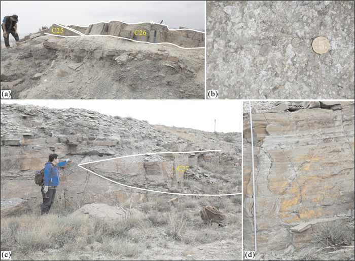
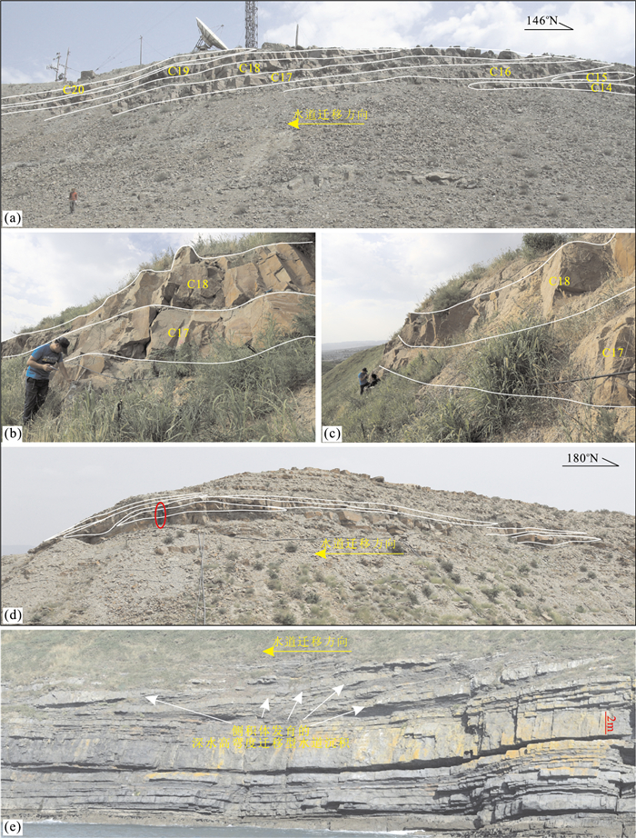

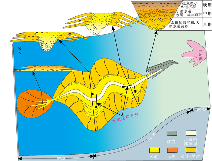
2018, 43(6): 2160-2171.
doi: 10.3799/dqkx.2017.586
Abstract:
This study focuses on the distribution and characteristics of hydrocarbon source rocks in Liaodong Bay area, and the related issues involving inconsistent evaluation standards and unclear development controlling factors, by using core, geochemistry and logging data. Firstly, the organic geochemical characteristics of main hydrocarbon source rocks in Dong-3, Sha-1 and Sha-3, are studied by the core and geochemistry data. Then the logging prediction model of organic carbon content and pyrolysed hydrocarbon is established with logging data to predict the plane distribution characteristics of hydrocarbon source rocks. Lastly, the main controlling factors of hydrocarbon source rocks are generalized on the basis of results of subsidence history, sedimentary background. The results show that the plane and vertical distributions of hydrocarbon source rocks are different; the tectonic subsidence rate, paleoproductivity, and salinity have correlation with organic carbon content. There are 5 hydrocarbon generation centers in Liaoxi and Liaozhong sags in the plane scale, and the quality of hydrocarbon source rocks in Liaozhong sag is better than that of Liaoxi sag, which gets increasingly worse from northeast to southwest. In vertical section, the hydrocarbon source rocks in Sha-1 is the best, good in Sha-3, but poor in Dong-3. It is found that the fast tectonic subsidence rate, high paleoproductivity and anaerobic environment caused by high salinity are the favorable factors for hydrocarbon source rock development in Liaodong Bay area.
This study focuses on the distribution and characteristics of hydrocarbon source rocks in Liaodong Bay area, and the related issues involving inconsistent evaluation standards and unclear development controlling factors, by using core, geochemistry and logging data. Firstly, the organic geochemical characteristics of main hydrocarbon source rocks in Dong-3, Sha-1 and Sha-3, are studied by the core and geochemistry data. Then the logging prediction model of organic carbon content and pyrolysed hydrocarbon is established with logging data to predict the plane distribution characteristics of hydrocarbon source rocks. Lastly, the main controlling factors of hydrocarbon source rocks are generalized on the basis of results of subsidence history, sedimentary background. The results show that the plane and vertical distributions of hydrocarbon source rocks are different; the tectonic subsidence rate, paleoproductivity, and salinity have correlation with organic carbon content. There are 5 hydrocarbon generation centers in Liaoxi and Liaozhong sags in the plane scale, and the quality of hydrocarbon source rocks in Liaozhong sag is better than that of Liaoxi sag, which gets increasingly worse from northeast to southwest. In vertical section, the hydrocarbon source rocks in Sha-1 is the best, good in Sha-3, but poor in Dong-3. It is found that the fast tectonic subsidence rate, high paleoproductivity and anaerobic environment caused by high salinity are the favorable factors for hydrocarbon source rock development in Liaodong Bay area.

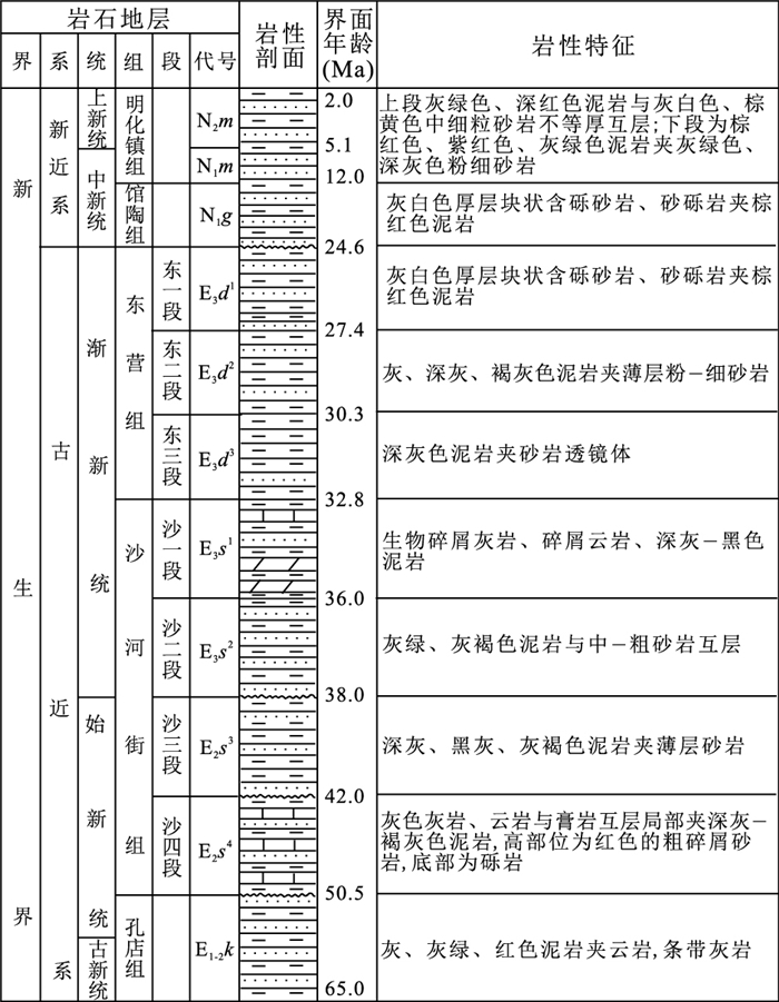


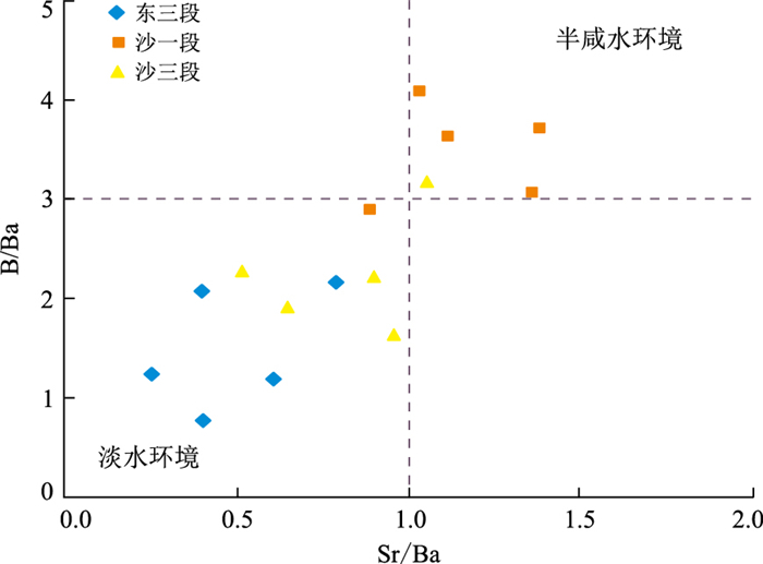
2018, 43(6): 2172-2183.
doi: 10.3799/dqkx.2017.615
Abstract:
The west basin canyon is a large cayon in the middle east of the Zhongjiannan basin in South China Sea. It appears to be NW direction, the depth of water is 2 850-4 300 m, and the length of it is about 188 km, the width is 1.8-14.5 km. It begins within the Zhongjiannan basin, and extends to the southwest sub-basin. The study of it provides a basis for the study of turbidite fan in the southwest sub-basin, and also provides scientific basis for deep understanding of the transportation model of turbidy currents. Based on the latest data of high resolution multi-beam depth sounding, single channel and multichannel seismic, this paper studies the morphological characteristics and structure and evolution of the west basin canyon. The results show the "segmentation" characteristics of the west basin canyon, including four stages:U type upper segment, V type middle upper segment, V bellow U type middle lower segment and U type lower segment, from the northwest to the southeast. The upper segment is mainly because of sedimentation processes, the infill of the multiphase incised valley reaches a thickness of 1 200 m; the middle-upper segment is mainly controlled by erosion-deposition, which leads to the formation of the turbidite sandstone body; the middle-lower segment is mainly controlled by erosion, which leads to the formation of the embankment and the mass flow deposit; the mass-flow and slip block deposited within the lower segment. The formation of the west basin canyon is influenced by palaeogeomorphology, erosion-deposition, sea-level change, tectonic movement, and magmatic activity, and the main controlling parameters are erosion-deposition, fault activity and sea-level change. The sedimentary evolution of the west basin canyon can be divided into 3 stages:the Middle Miocene canyon breeds stage, the Late Miocene sea canyon erosion and filling stage, the Pliocene-Quaternary canyon "rejuvenation" stage.
The west basin canyon is a large cayon in the middle east of the Zhongjiannan basin in South China Sea. It appears to be NW direction, the depth of water is 2 850-4 300 m, and the length of it is about 188 km, the width is 1.8-14.5 km. It begins within the Zhongjiannan basin, and extends to the southwest sub-basin. The study of it provides a basis for the study of turbidite fan in the southwest sub-basin, and also provides scientific basis for deep understanding of the transportation model of turbidy currents. Based on the latest data of high resolution multi-beam depth sounding, single channel and multichannel seismic, this paper studies the morphological characteristics and structure and evolution of the west basin canyon. The results show the "segmentation" characteristics of the west basin canyon, including four stages:U type upper segment, V type middle upper segment, V bellow U type middle lower segment and U type lower segment, from the northwest to the southeast. The upper segment is mainly because of sedimentation processes, the infill of the multiphase incised valley reaches a thickness of 1 200 m; the middle-upper segment is mainly controlled by erosion-deposition, which leads to the formation of the turbidite sandstone body; the middle-lower segment is mainly controlled by erosion, which leads to the formation of the embankment and the mass flow deposit; the mass-flow and slip block deposited within the lower segment. The formation of the west basin canyon is influenced by palaeogeomorphology, erosion-deposition, sea-level change, tectonic movement, and magmatic activity, and the main controlling parameters are erosion-deposition, fault activity and sea-level change. The sedimentary evolution of the west basin canyon can be divided into 3 stages:the Middle Miocene canyon breeds stage, the Late Miocene sea canyon erosion and filling stage, the Pliocene-Quaternary canyon "rejuvenation" stage.


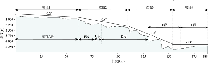


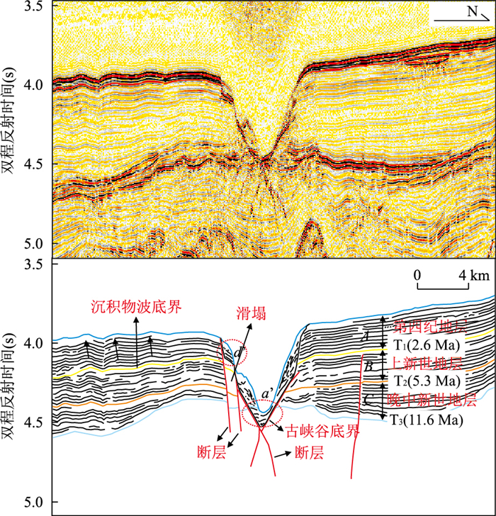
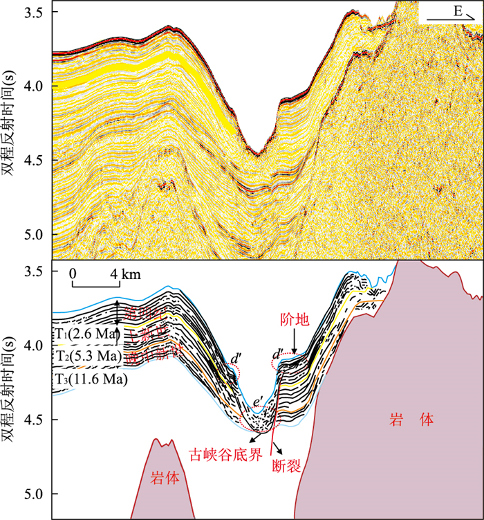

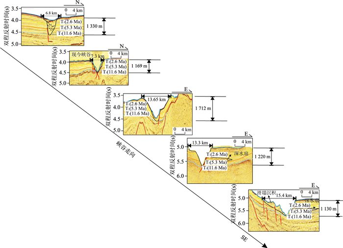
2018, 43(6): 2184-2194.
doi: 10.3799/dqkx.2018.612
Abstract:
The retrieval of organic matter content in black soil is of great significance for the utilization and conservation of black soil resources. However, the lack of hyperspectral satellite images has restricted the development of soil organic matter retrieval at the regional scale. In this paper, a typical black soil area of Heilongjiang Province was selected as the study area. Then, the CASI/SASI airborne hyperspectral data, ASD(analytical spectral devices) surface spectral data, and the soil organic matter content data are used to establish the optimal regression model based on the correlation and quantitative relationship between organic matter content and spectral reflectance values of soil samples. Finally, the retrieval of soil organic matter content of the study area is carried out. The results show that the partial least square regression model is more stable than the multivariate stepwise regression model (with determination coefficients of 0.885 and 0.653, respectively), and the accuracy is higher (with root mean square error of 0.424 and 0.744, respectively). The retrieval result derived from partial least square regression is basically consistent with the result of geochemical exploration on the ground.
The retrieval of organic matter content in black soil is of great significance for the utilization and conservation of black soil resources. However, the lack of hyperspectral satellite images has restricted the development of soil organic matter retrieval at the regional scale. In this paper, a typical black soil area of Heilongjiang Province was selected as the study area. Then, the CASI/SASI airborne hyperspectral data, ASD(analytical spectral devices) surface spectral data, and the soil organic matter content data are used to establish the optimal regression model based on the correlation and quantitative relationship between organic matter content and spectral reflectance values of soil samples. Finally, the retrieval of soil organic matter content of the study area is carried out. The results show that the partial least square regression model is more stable than the multivariate stepwise regression model (with determination coefficients of 0.885 and 0.653, respectively), and the accuracy is higher (with root mean square error of 0.424 and 0.744, respectively). The retrieval result derived from partial least square regression is basically consistent with the result of geochemical exploration on the ground.