2019 Vol. 44, No. 2
Display Method:
 PDF 302KB
2019, 44(2): 355-365.
doi: 10.3799/dqkx.2018.541
Abstract:
In-situ zircon U-Pb ages are reported for the meta-bimodal volcanic suite of rhyolites and basalts from the Dingyuan Formation in the western Dabie orogen. The rhyolite, the rhyolitic tuff, and the basalt yield zircon U-Pb ages of 737±5 Ma (1σ, MSWD=0.02), 740±3 Ma (1σ, MSWD=0.07), 740±5 Ma (1σ, MSWD=0.07) and 739±6 Ma (1σ, MSWD=0.07), respectively, indicating that the bimodal suite was erupted during the Neoproterozoic. Intensive magmatic rocks were widespread throughout the South Qinling, Suizao, western Dabie and eastern Dabie areas during 755 to 730 Ma, such as the Yaolinghe Group, the Suixian Group, the Hong'an Group and the Dingyuan Formation. These igneous rocks show peak ages at ca.740 Ma, indicating a continental rift extensional setting in the northern margin of the Yangtze Block during the breakup of supercontinent Rodinia.
In-situ zircon U-Pb ages are reported for the meta-bimodal volcanic suite of rhyolites and basalts from the Dingyuan Formation in the western Dabie orogen. The rhyolite, the rhyolitic tuff, and the basalt yield zircon U-Pb ages of 737±5 Ma (1σ, MSWD=0.02), 740±3 Ma (1σ, MSWD=0.07), 740±5 Ma (1σ, MSWD=0.07) and 739±6 Ma (1σ, MSWD=0.07), respectively, indicating that the bimodal suite was erupted during the Neoproterozoic. Intensive magmatic rocks were widespread throughout the South Qinling, Suizao, western Dabie and eastern Dabie areas during 755 to 730 Ma, such as the Yaolinghe Group, the Suixian Group, the Hong'an Group and the Dingyuan Formation. These igneous rocks show peak ages at ca.740 Ma, indicating a continental rift extensional setting in the northern margin of the Yangtze Block during the breakup of supercontinent Rodinia.


2019, 44(2): 366-386.
doi: 10.3799/dqkx.2018.262
Abstract:
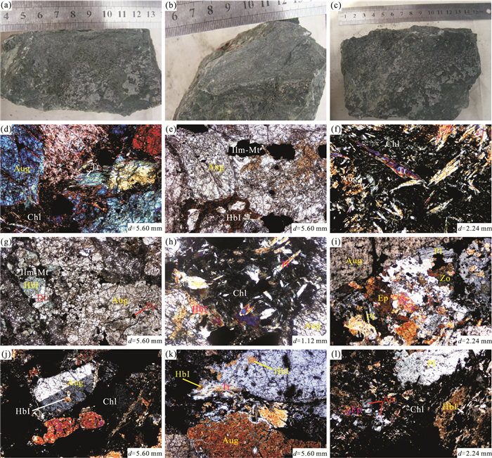
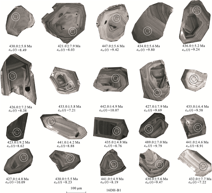
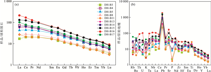
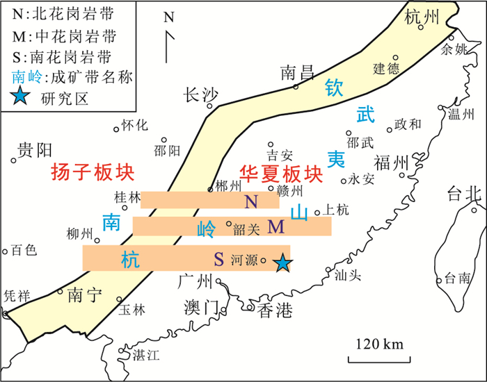
The Donghe Pt-Pd-bearing ultramafic dykes are located in the northern margin of the Yangtze block in Fangxian, the Pt-Pd ore bodys are present in the ultramafic dykes of pyroxene veins. The LA-ICP-MS zircon U-Pb dating indicates that the ultrabasic dykes were emplaced with age of 433.2±2.9 Ma, belonging to the early Silurian.The rocks are characterized by low SiO2 (39.73%-47.46%, mean 41.41%), moderate Mg# (46.98-67.37) and high alumina (11.25%-15.46%), belonging to high-alumina ultrabasic rocks. The rocks have higher total REE, with slightly enriched LREE and without significant Eu positive anomaly (∑REE=59.59×10⁻⁶ to 375.02×10⁻⁶, (LaN/YbN)=3.94-19.13, δEu=0.93-1.13). All rocks are enriched in Rb, Ba, Sr, Nb, Ti, etc., depleted in Nb, Hf, P, etc. and have significantly different ratios of incompatible elements to that in the crust. Sr, Nd and Hf isotope studies show that the Donghe ultramafic rocks have low initial 87Sr/86Sr ratios (0.703 26-0.704 15), positive εNd(t)(4.37~5.27) and positive εHf(t) (7.29-10.26).Based on the above discussion, we propose that the studied ultramafic rocks were derived from a depleted lithospheric mantle(garnet-lherzolite) source which may be enriched lithospheric mantle components. Magma in the rising process was not significantly affected by the crust material mixed. The tectonic discrimination of trace elements shows that it formed in intraplate tectonic environment. The analysis shows the Donghe region should be on the passive continental margin during the Early Silurian and should be in extensional state. The two-stage ultramafic bedrocks (veins) exposed in the study area were the products of the early stage of the continental rift in the state of extensional of the lithosphere.
The Donghe Pt-Pd-bearing ultramafic dykes are located in the northern margin of the Yangtze block in Fangxian, the Pt-Pd ore bodys are present in the ultramafic dykes of pyroxene veins. The LA-ICP-MS zircon U-Pb dating indicates that the ultrabasic dykes were emplaced with age of 433.2±2.9 Ma, belonging to the early Silurian.The rocks are characterized by low SiO2 (39.73%-47.46%, mean 41.41%), moderate Mg# (46.98-67.37) and high alumina (11.25%-15.46%), belonging to high-alumina ultrabasic rocks. The rocks have higher total REE, with slightly enriched LREE and without significant Eu positive anomaly (∑REE=59.59×10⁻⁶ to 375.02×10⁻⁶, (LaN/YbN)=3.94-19.13, δEu=0.93-1.13). All rocks are enriched in Rb, Ba, Sr, Nb, Ti, etc., depleted in Nb, Hf, P, etc. and have significantly different ratios of incompatible elements to that in the crust. Sr, Nd and Hf isotope studies show that the Donghe ultramafic rocks have low initial 87Sr/86Sr ratios (0.703 26-0.704 15), positive εNd(t)(4.37~5.27) and positive εHf(t) (7.29-10.26).Based on the above discussion, we propose that the studied ultramafic rocks were derived from a depleted lithospheric mantle(garnet-lherzolite) source which may be enriched lithospheric mantle components. Magma in the rising process was not significantly affected by the crust material mixed. The tectonic discrimination of trace elements shows that it formed in intraplate tectonic environment. The analysis shows the Donghe region should be on the passive continental margin during the Early Silurian and should be in extensional state. The two-stage ultramafic bedrocks (veins) exposed in the study area were the products of the early stage of the continental rift in the state of extensional of the lithosphere.


2019, 44(2): 387-398.
doi: 10.3799/dqkx.2018.113
Abstract:
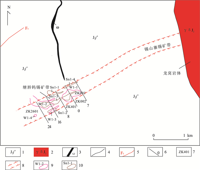
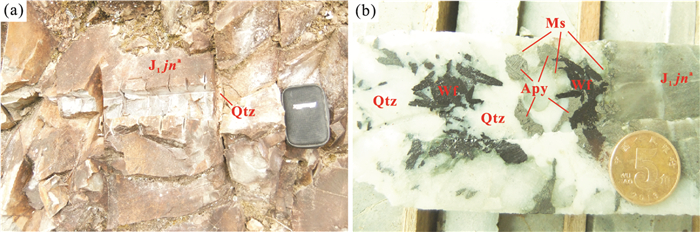
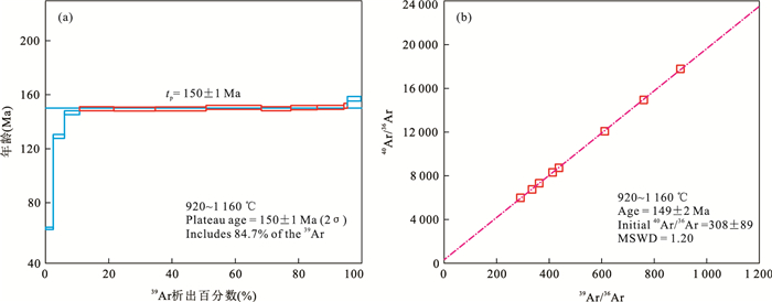
The Tangchun tungsten(tin) deposit is a newly discovered quartz vein type deposit and the potential for prospecting is huge. The deposit occurs in the western outer contact zone of the Longwo granodiorite pluton in Eastern Guangdong Province. The ore-hosting strata are the clastic rocks of the Lower Jurassic Jinji formation, which are considered to be the youngest ore-hosting strata in the Nanling and its adjacent areas.On the basis of detailed field geological surveys, a muscovite 40Ar-39Ar plateau age of 150±1 Ma and an isochron age of 149±2 Ma (MSWD=1.20) have been obtained for a W-bearing quartz vein in the deposit, which are the same within the analytical uncertainties. Our 40Ar-39Ar dating results have shown that the Tangchun tungsten (tin) deposit was the product of early Yanshanian large scale petrogenesis and metallogenesis in the Nanling Range. The newly discovered Tangchun tungsten (tin) deposit is of great guiding significance in exploration since it not only broadens our mind in prospecting for quartz vein type tungsten-tin deposit, but also provides an opportunity to thoroughly unravel the metallogenic regularity as well as metallogenic models of the quartz vein type tungsten-tin deposit.
The Tangchun tungsten(tin) deposit is a newly discovered quartz vein type deposit and the potential for prospecting is huge. The deposit occurs in the western outer contact zone of the Longwo granodiorite pluton in Eastern Guangdong Province. The ore-hosting strata are the clastic rocks of the Lower Jurassic Jinji formation, which are considered to be the youngest ore-hosting strata in the Nanling and its adjacent areas.On the basis of detailed field geological surveys, a muscovite 40Ar-39Ar plateau age of 150±1 Ma and an isochron age of 149±2 Ma (MSWD=1.20) have been obtained for a W-bearing quartz vein in the deposit, which are the same within the analytical uncertainties. Our 40Ar-39Ar dating results have shown that the Tangchun tungsten (tin) deposit was the product of early Yanshanian large scale petrogenesis and metallogenesis in the Nanling Range. The newly discovered Tangchun tungsten (tin) deposit is of great guiding significance in exploration since it not only broadens our mind in prospecting for quartz vein type tungsten-tin deposit, but also provides an opportunity to thoroughly unravel the metallogenic regularity as well as metallogenic models of the quartz vein type tungsten-tin deposit.

2019, 44(2): 399-414.
doi: 10.3799/dqkx.2018.123
Abstract:
The limestone of the upper Ordovician Baota Formation in northwestern Hunan has a crack structure, bearing the characteristics of "decreasing cracks from top-bottom, no crossing between adjacent layers, multi-period deformation, water-like filling" in rock sequence, which is a special sedimentary structure in geological period. In order to find out its genetic mechanism and its internal relationship with the evolution of the Yangtze basin, the author does research from aspects including lithology, fracture characteristics, geochemical characteristics, basin model and comprehensive comparison of the known causes of crack-like polygonal reticulate structure. It is found that the crack structure is a kind of initial slit formed under the influence pen contemporaneous gel condensation. Then under the control of tectonic extrusion, the basin sinks rapidly, a fluid environment in an abnormal high pressure filed is formed in the basin, which leads to squeezing, filling and initial cracks reconstruction from the plaster material in underlying water-rich rocks. This study on the crack structure of the Baota Formation provides petrological data for the study on the mechanism of tectonic-fluid-rock interaction. Meanwhile, a good dredging function of the cracks has an important practical significance for the study on mineralization as well as oil and gas accumulation.
The limestone of the upper Ordovician Baota Formation in northwestern Hunan has a crack structure, bearing the characteristics of "decreasing cracks from top-bottom, no crossing between adjacent layers, multi-period deformation, water-like filling" in rock sequence, which is a special sedimentary structure in geological period. In order to find out its genetic mechanism and its internal relationship with the evolution of the Yangtze basin, the author does research from aspects including lithology, fracture characteristics, geochemical characteristics, basin model and comprehensive comparison of the known causes of crack-like polygonal reticulate structure. It is found that the crack structure is a kind of initial slit formed under the influence pen contemporaneous gel condensation. Then under the control of tectonic extrusion, the basin sinks rapidly, a fluid environment in an abnormal high pressure filed is formed in the basin, which leads to squeezing, filling and initial cracks reconstruction from the plaster material in underlying water-rich rocks. This study on the crack structure of the Baota Formation provides petrological data for the study on the mechanism of tectonic-fluid-rock interaction. Meanwhile, a good dredging function of the cracks has an important practical significance for the study on mineralization as well as oil and gas accumulation.


2019, 44(2): 415-426.
doi: 10.3799/dqkx.2018.198
Abstract:
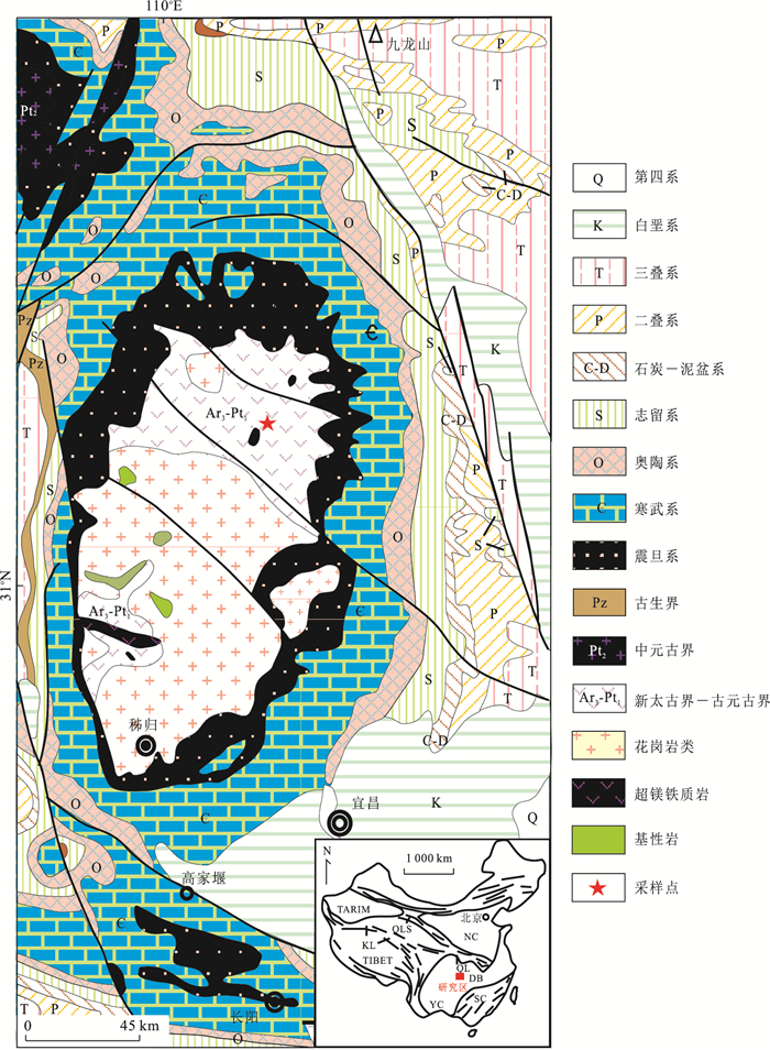
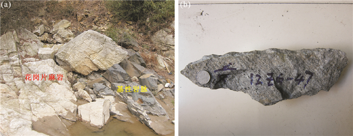
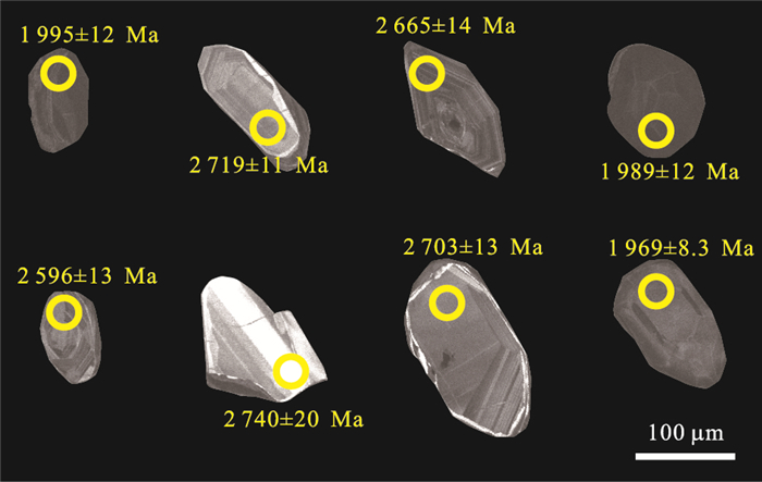
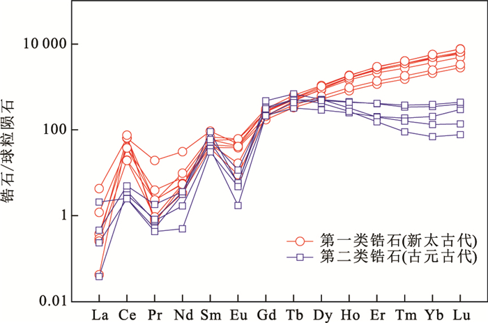
This study carries out systematical geochronological and whole-rock geochemical investigations for the Neoarchean granitic gneisses of the Kongling complex, and discusses the petrogenesis and~3.0-2.6 Ga tectonic evolution of the nucleus of the Yangtze craton. The zircon LA-ICP-MS U-Pb dating reveals that the gneisses were crystallized at 2 673±39 Ma, and experienced high-pressure granulite-facies metamorphism at 2 042±27 Ma. The geochemical study illustrates an enrichment of Si and depletions of Mg, Cr and Ni, as well as negative anomalies of high field strength elements, Eu and Sr. The εNd(t) values of the gneisses vary between -1.9 to -0.1 and the corresponding two-stage Nd isotopic model ages range from 3.15-3.01 Ga, combined with their relatively high calculated zircon saturation temperature (789-825℃), indicating that the Kongling Neoarchean gneisses might have formed by partial melting of juvenile felsic crustal materials under a high-temperature condition in the post-collisional extensional tectonic setting. Combined with the documented work, it is suggested that the nucleus of the Yangtze craton, represented by the Kongling complex, may fully record an~2.9-2.6 Ga orogenic-related event including earlier stage of oceanic slab subduction, middle stage of arc (or continent)-continent collision, and later stage of post-collisional extension.
This study carries out systematical geochronological and whole-rock geochemical investigations for the Neoarchean granitic gneisses of the Kongling complex, and discusses the petrogenesis and~3.0-2.6 Ga tectonic evolution of the nucleus of the Yangtze craton. The zircon LA-ICP-MS U-Pb dating reveals that the gneisses were crystallized at 2 673±39 Ma, and experienced high-pressure granulite-facies metamorphism at 2 042±27 Ma. The geochemical study illustrates an enrichment of Si and depletions of Mg, Cr and Ni, as well as negative anomalies of high field strength elements, Eu and Sr. The εNd(t) values of the gneisses vary between -1.9 to -0.1 and the corresponding two-stage Nd isotopic model ages range from 3.15-3.01 Ga, combined with their relatively high calculated zircon saturation temperature (789-825℃), indicating that the Kongling Neoarchean gneisses might have formed by partial melting of juvenile felsic crustal materials under a high-temperature condition in the post-collisional extensional tectonic setting. Combined with the documented work, it is suggested that the nucleus of the Yangtze craton, represented by the Kongling complex, may fully record an~2.9-2.6 Ga orogenic-related event including earlier stage of oceanic slab subduction, middle stage of arc (or continent)-continent collision, and later stage of post-collisional extension.


2019, 44(2): 427-440.
doi: 10.3799/dqkx.2018.343
Abstract:
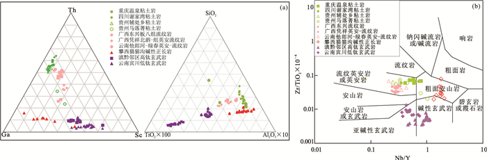
The Lower-Middle Triassic boundary clay rocks (LMTBC, for short), related to volcanic material eruption and deposition, are rich in lithium and widespread in Chongqing, Guangxi, Guizhou of southwest China. It is of great economic significance to evaluate the ore-forming potential of sedimentary clay-type lithium deposit and confirm the prospecting direction in LMTBC. Based on the method of chronology and geochemistry, MC-ICP-MS zircon U-Pb data indicates that the formation ages of LMTBC from Wenquan, Xiejiawan, Fuchu, Maluojing are 248.6±0.8 Ma, 242.5±0.7 Ma, 246.1±0.6 Ma, 248.1±0.8 Ma, and they all are close to the Lower-Middle Triassic boundary age (247.2 Ma). The geochemical data indicate that LMTBC is enriched in Li, K2O, high of MgO and depleted in Na2O, and displays high incompatible elements (Rb, W, Sn, Bi, Th, and U) abundances and low compatible element (V, Cr, Co and Ni) abundances. The Li shows positive correlation with the incompatible elements (Sn, Ta, and Ga), which is similar to rhyolitic-dacitic rocks. All above data suggest that LMTBC is the products of the clay-alteration from the Triassic multiple-stages volcanic eruption-deposit materials. Considering the spatio-temporal relationship geochemical characteristics of LMTBC and rhyolitic-dacitic igneous rocks in southwest China, it is suggested that the tectonic setting of volcanic activities is possibly the subduction and collision of Yangtze plate and Cathaysia plate, or the hydrothermal-sedimentary activities of subsequent Emei great igneous province. The inheritance component of the volcanic sedimentary materials is the key factor for Li anomalies of LMTBC, the ions adsorption effect of clay minerals may be also important; the superposition action of lithium rich brine caused by the evaporation hardly caused the large-scale lithium-rich LMTBC. Accordinlgly, it is suggested that the clay layers of LMTBC volcanic eruption-sedimentary origin are the ideal bedding for discovering the clay-type lithium deposits in southwest China. The contemporary ancient crater basins and similar paleogeomorphology are the favorable preservation of eruption sediments, and the important prospecting area for clay-type lithium deposits.
The Lower-Middle Triassic boundary clay rocks (LMTBC, for short), related to volcanic material eruption and deposition, are rich in lithium and widespread in Chongqing, Guangxi, Guizhou of southwest China. It is of great economic significance to evaluate the ore-forming potential of sedimentary clay-type lithium deposit and confirm the prospecting direction in LMTBC. Based on the method of chronology and geochemistry, MC-ICP-MS zircon U-Pb data indicates that the formation ages of LMTBC from Wenquan, Xiejiawan, Fuchu, Maluojing are 248.6±0.8 Ma, 242.5±0.7 Ma, 246.1±0.6 Ma, 248.1±0.8 Ma, and they all are close to the Lower-Middle Triassic boundary age (247.2 Ma). The geochemical data indicate that LMTBC is enriched in Li, K2O, high of MgO and depleted in Na2O, and displays high incompatible elements (Rb, W, Sn, Bi, Th, and U) abundances and low compatible element (V, Cr, Co and Ni) abundances. The Li shows positive correlation with the incompatible elements (Sn, Ta, and Ga), which is similar to rhyolitic-dacitic rocks. All above data suggest that LMTBC is the products of the clay-alteration from the Triassic multiple-stages volcanic eruption-deposit materials. Considering the spatio-temporal relationship geochemical characteristics of LMTBC and rhyolitic-dacitic igneous rocks in southwest China, it is suggested that the tectonic setting of volcanic activities is possibly the subduction and collision of Yangtze plate and Cathaysia plate, or the hydrothermal-sedimentary activities of subsequent Emei great igneous province. The inheritance component of the volcanic sedimentary materials is the key factor for Li anomalies of LMTBC, the ions adsorption effect of clay minerals may be also important; the superposition action of lithium rich brine caused by the evaporation hardly caused the large-scale lithium-rich LMTBC. Accordinlgly, it is suggested that the clay layers of LMTBC volcanic eruption-sedimentary origin are the ideal bedding for discovering the clay-type lithium deposits in southwest China. The contemporary ancient crater basins and similar paleogeomorphology are the favorable preservation of eruption sediments, and the important prospecting area for clay-type lithium deposits.


2019, 44(2): 441-455.
doi: 10.3799/dqkx.2018.288
Abstract:
The Tongshankou deposit is a typical skarn-porphyry Cu (Mo) deposit in the East Hubei Province, thick tungsten ore bodies have been discovered in deep part of this deposit recently. In this paper, systematic researches on geological characteristics, petrology, and mineralogy were carried out on tungsten mineralization from the Tongshankou deposit. It is found that tungsten ore bodies were mainly produced at or near the contact zone between sedimentary rocks and granodioritic porphyry. Therefore, their occurrences are controlled by the shape of contact surface.Tungsten can be produced either as a separate tungsten ore body or as a byproduct element in Cu and Mo ore bodies. Scheelite is the mainly tungsten-bearing mineral, and is characterized by a significant enrichment of Mo. Tungsten mineralization process of the Tongshankou deposit is temporally, spatially and genetically associated with skarn alteration, and these features are consistent with those of oxidized W skarns. Tungsten and Cu mineralization are the product of different stages from the same magmatic-hydrothermal process, but the location of W ore bodies are relatively deeper than that of Cu. The Tongshankou porphyry stock shears a lot of similarities with stocks associated with W mineralization in East Hubei Province, suggesting that they were probably partly controlled by Cu and W fertile Jiangnan basement, and the connect part of Jiangnan and Dongling basement under the East Hubei Province probably located nearby the Yangxinpluton.
The Tongshankou deposit is a typical skarn-porphyry Cu (Mo) deposit in the East Hubei Province, thick tungsten ore bodies have been discovered in deep part of this deposit recently. In this paper, systematic researches on geological characteristics, petrology, and mineralogy were carried out on tungsten mineralization from the Tongshankou deposit. It is found that tungsten ore bodies were mainly produced at or near the contact zone between sedimentary rocks and granodioritic porphyry. Therefore, their occurrences are controlled by the shape of contact surface.Tungsten can be produced either as a separate tungsten ore body or as a byproduct element in Cu and Mo ore bodies. Scheelite is the mainly tungsten-bearing mineral, and is characterized by a significant enrichment of Mo. Tungsten mineralization process of the Tongshankou deposit is temporally, spatially and genetically associated with skarn alteration, and these features are consistent with those of oxidized W skarns. Tungsten and Cu mineralization are the product of different stages from the same magmatic-hydrothermal process, but the location of W ore bodies are relatively deeper than that of Cu. The Tongshankou porphyry stock shears a lot of similarities with stocks associated with W mineralization in East Hubei Province, suggesting that they were probably partly controlled by Cu and W fertile Jiangnan basement, and the connect part of Jiangnan and Dongling basement under the East Hubei Province probably located nearby the Yangxinpluton.


2019, 44(2): 456-462.
doi: 10.3799/dqkx.2018.557
Abstract:
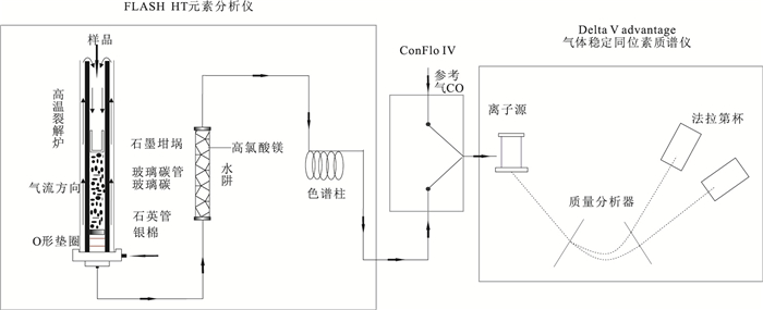
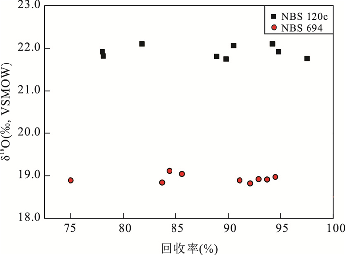
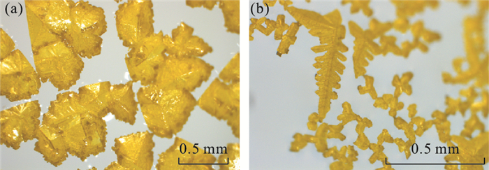
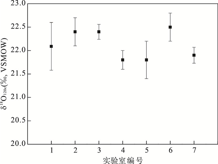
The oxygen isotope composition of phosphate (δ18OPO4) in bioapatite plays a significant role in paleo-environmental research as one of the ideal proxies for paleo-temperature reconstruction. However, for trace bioapatite(e.g., conodonts), a reliable pre-treatment technology is quite important and difficult for its δ18OPO4 analysis, resulting in analytical technique established only in several overseas laboratories. Here we combine the advantages of those methods and present a protocol on the analysis of δ18OPO4 as Ag3PO4 for bioapatite of total sample size as small as 0.2 mg using a thermal conversion elemental analyzer (TC/EA) coupled to a continuous flow isotope ratio mass spectrometer (CF-IRMS) via a helium stream. Ag3PO4 is precipitated by NH3 buffer method after apatite being dissolved with nitric acid, Ca2+ being removed with KF solution and the solution being neutralized with ammonia buffer solution. The results indicate that analysis of δ18OPO4 maintains an external precision of ±0.2‰(1σ), meeting the international analytical standards. This method for analyzing δ18OPO4 of phosphate extracted from bioapatite is robust to be used to reconstruct paleo-temperature.
The oxygen isotope composition of phosphate (δ18OPO4) in bioapatite plays a significant role in paleo-environmental research as one of the ideal proxies for paleo-temperature reconstruction. However, for trace bioapatite(e.g., conodonts), a reliable pre-treatment technology is quite important and difficult for its δ18OPO4 analysis, resulting in analytical technique established only in several overseas laboratories. Here we combine the advantages of those methods and present a protocol on the analysis of δ18OPO4 as Ag3PO4 for bioapatite of total sample size as small as 0.2 mg using a thermal conversion elemental analyzer (TC/EA) coupled to a continuous flow isotope ratio mass spectrometer (CF-IRMS) via a helium stream. Ag3PO4 is precipitated by NH3 buffer method after apatite being dissolved with nitric acid, Ca2+ being removed with KF solution and the solution being neutralized with ammonia buffer solution. The results indicate that analysis of δ18OPO4 maintains an external precision of ±0.2‰(1σ), meeting the international analytical standards. This method for analyzing δ18OPO4 of phosphate extracted from bioapatite is robust to be used to reconstruct paleo-temperature.


2019, 44(2): 463-474.
doi: 10.3799/dqkx.2017.620
Abstract:
As a result of the excavation of building construction, 6 small size fresh faults exposed in Wujialong of Jiangshan City, Zhejiang Province, which was sub-branch of Jiangshao fault. Field geological survey, X-ray powder diffraction and Mössbauer spectroscopy were used to study the mineral composition and iron species of fault gouges and wall rocks of 3 small faults (F1, F2 and F3) in Wujialong fault. After comparative analysis and research we found that:(1) The wall rocks and fault gouges are mainly composed of quartz and clay minerals, and also contain a small amount of albite and calcite. The clay minerals are mainly composed of illite and IS layer, and also contain small amount of chlorite, kaolinite and KS layer and trace amount of montmorillonite and vermiculite. (2) Except the JS07 sample, the rock forming minerals content is higher than that of fault gouges whereas to the clay content in fault gouges is higher than that of wall rocks. (3) Clay mineral in F1 fault is dominated by illite, indicating a relative stable environment. The content of illite in F2 and F3 fault gouges are lower than that in wall rocks, montmorillonite and IS layer is higher than that in wall rocks, indicating that it was formed in wet, strong oxidizing environment. (4) The high content of reduced iron of wall rocks in F1 may suggest that the formation of wall rocks is involved in the process of reducing substances, the high levels of oxidized iron of F1, F3 fault zone and F3 hanger, indicating either F1, F3 faults are inactive and/or they are inner-block fault. (5) The types and association of clay minerals in the fault zone and the redox environment generally show that the Wujialong fault is in a relatively stable environment, however, the content of illite in the fault zone is high, which is conducive to the fault activity. The activity of Wujialong fault and the possibility of earthquake should be taken into consideration seriously.
As a result of the excavation of building construction, 6 small size fresh faults exposed in Wujialong of Jiangshan City, Zhejiang Province, which was sub-branch of Jiangshao fault. Field geological survey, X-ray powder diffraction and Mössbauer spectroscopy were used to study the mineral composition and iron species of fault gouges and wall rocks of 3 small faults (F1, F2 and F3) in Wujialong fault. After comparative analysis and research we found that:(1) The wall rocks and fault gouges are mainly composed of quartz and clay minerals, and also contain a small amount of albite and calcite. The clay minerals are mainly composed of illite and IS layer, and also contain small amount of chlorite, kaolinite and KS layer and trace amount of montmorillonite and vermiculite. (2) Except the JS07 sample, the rock forming minerals content is higher than that of fault gouges whereas to the clay content in fault gouges is higher than that of wall rocks. (3) Clay mineral in F1 fault is dominated by illite, indicating a relative stable environment. The content of illite in F2 and F3 fault gouges are lower than that in wall rocks, montmorillonite and IS layer is higher than that in wall rocks, indicating that it was formed in wet, strong oxidizing environment. (4) The high content of reduced iron of wall rocks in F1 may suggest that the formation of wall rocks is involved in the process of reducing substances, the high levels of oxidized iron of F1, F3 fault zone and F3 hanger, indicating either F1, F3 faults are inactive and/or they are inner-block fault. (5) The types and association of clay minerals in the fault zone and the redox environment generally show that the Wujialong fault is in a relatively stable environment, however, the content of illite in the fault zone is high, which is conducive to the fault activity. The activity of Wujialong fault and the possibility of earthquake should be taken into consideration seriously.


2019, 44(2): 475-488.
doi: 10.3799/dqkx.2018.579
Abstract:
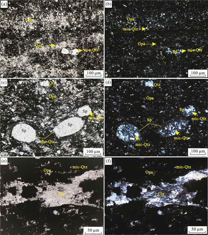
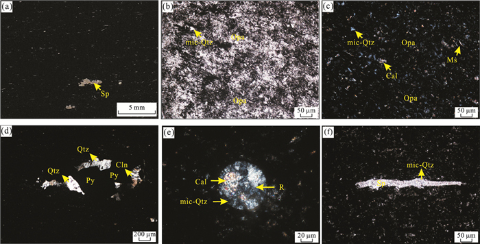
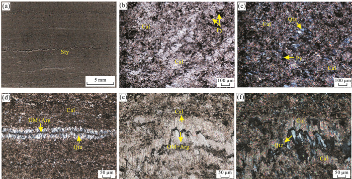
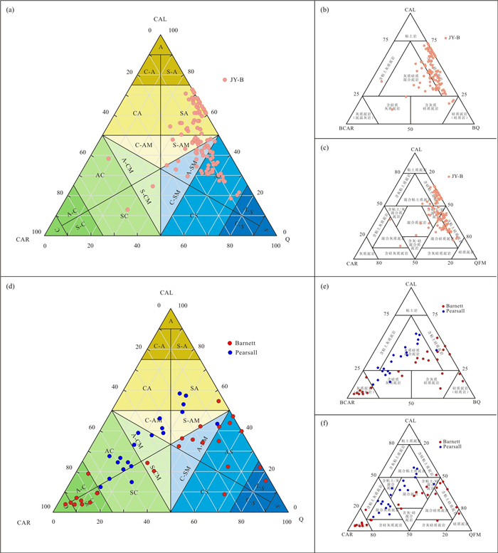
Ancient deep-marine siliceous-argillaceous-carbonate rock series (SAC) are general name of silicalite, argillite, carbonate rock and their mixed deposit rocks which are all pelagic and hemipelagic sediments. In this paper, it proposes a new mineralogy-based classification scheme of the SAC rock series based on existing classifications. According to quantitative classification standard["pure (>90%)", "dominate(50%-90%)", "rich(50%-25%)", "bearing (< 25%)"] and using triangular midlines of the ternary plot, the SAC rock series are divided into 4 primary classes and 21 classes. By using the new classification, silicalite, carbonate rock and mixed mudstone primary classes are present in the Lower-Middle Cambrian in the Lower Yangtze region and their petrological features are described by optical microscope observation. The SAC rock series of the Lower-Middle Cambrian show the sedimentary evolution trend from siliceous end to carbonate end. The results of classification of three typical SAC rock series indicate that the new classification scheme clearly reflects the mixed sedimentary evolution trend among three terminal minerals. The classification of the SAC rock series may help provide a significant foundation to quantitative description of the ancient pelagic and hemipelagic sedimentation, and also provide an important basis for exploring the evolution of sedimentary environment.
Ancient deep-marine siliceous-argillaceous-carbonate rock series (SAC) are general name of silicalite, argillite, carbonate rock and their mixed deposit rocks which are all pelagic and hemipelagic sediments. In this paper, it proposes a new mineralogy-based classification scheme of the SAC rock series based on existing classifications. According to quantitative classification standard["pure (>90%)", "dominate(50%-90%)", "rich(50%-25%)", "bearing (< 25%)"] and using triangular midlines of the ternary plot, the SAC rock series are divided into 4 primary classes and 21 classes. By using the new classification, silicalite, carbonate rock and mixed mudstone primary classes are present in the Lower-Middle Cambrian in the Lower Yangtze region and their petrological features are described by optical microscope observation. The SAC rock series of the Lower-Middle Cambrian show the sedimentary evolution trend from siliceous end to carbonate end. The results of classification of three typical SAC rock series indicate that the new classification scheme clearly reflects the mixed sedimentary evolution trend among three terminal minerals. The classification of the SAC rock series may help provide a significant foundation to quantitative description of the ancient pelagic and hemipelagic sedimentation, and also provide an important basis for exploring the evolution of sedimentary environment.


2019, 44(2): 489-503.
doi: 10.3799/dqkx.2018.519
Abstract:
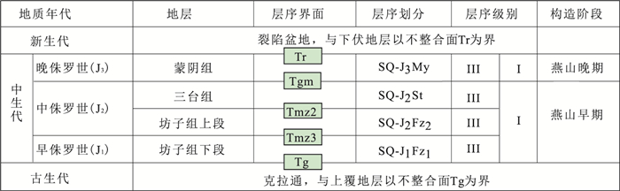
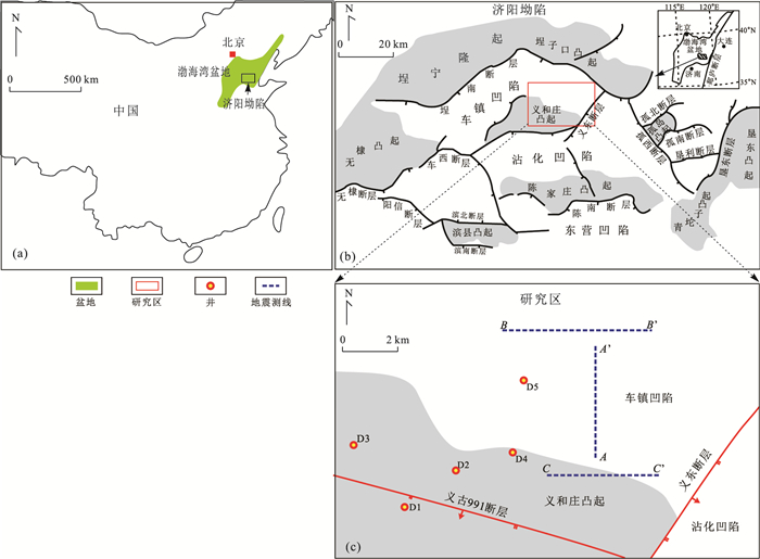
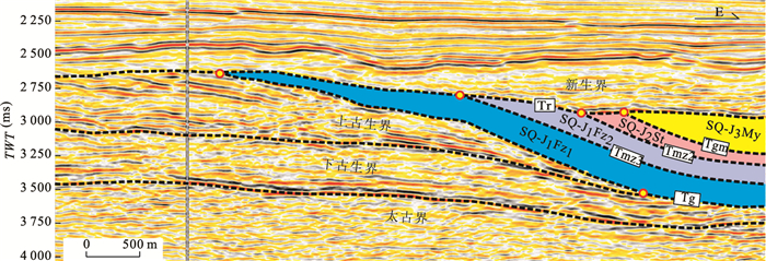
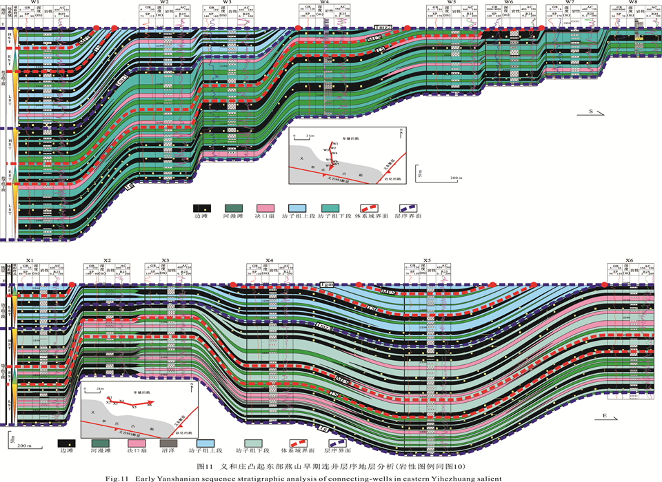
Through boreholes, well logs and seismic profiles, one tectonic inversion happening between Middle Jurassic and Late Jurassic is recognized in Yanshanian eastern Yihezhuang salient based on analyzing unconformity surfaces, faulting activity and the negative structure of strata, which divides the Yanshanian of eastern Yihezhuang salient into Early Yanshanian and Late Yanshanian in this study. The sequence stratigraphic patterns of Early Yanshanian and Late Yanshanian are respectively established with analysis of single-well sequence stratigraphy and connecting-well sequence stratigraphy, which shows great difference in sequence structure and internal makeup with each other. During early Yanshanian, the sequence stratigraphy showed unobvious thickness differentiation and the sequence-infill were fluvial facies. Differently, the sequence stratigraphy presented obvious thickness differentiation and was infilled mainly with fan deltas, as the tectonic inversion led to development of small rifted-basin, which showed obvious response to the recognized tectonic inversion. Applying tectonic-sequence stratigraphy to Yanshanian succession could contribute to the pre-Cenezoic hydrocarbon exploration of the basins with similar tectonic background in eastern China.
Through boreholes, well logs and seismic profiles, one tectonic inversion happening between Middle Jurassic and Late Jurassic is recognized in Yanshanian eastern Yihezhuang salient based on analyzing unconformity surfaces, faulting activity and the negative structure of strata, which divides the Yanshanian of eastern Yihezhuang salient into Early Yanshanian and Late Yanshanian in this study. The sequence stratigraphic patterns of Early Yanshanian and Late Yanshanian are respectively established with analysis of single-well sequence stratigraphy and connecting-well sequence stratigraphy, which shows great difference in sequence structure and internal makeup with each other. During early Yanshanian, the sequence stratigraphy showed unobvious thickness differentiation and the sequence-infill were fluvial facies. Differently, the sequence stratigraphy presented obvious thickness differentiation and was infilled mainly with fan deltas, as the tectonic inversion led to development of small rifted-basin, which showed obvious response to the recognized tectonic inversion. Applying tectonic-sequence stratigraphy to Yanshanian succession could contribute to the pre-Cenezoic hydrocarbon exploration of the basins with similar tectonic background in eastern China.


2019, 44(2): 504-512.
doi: 10.3799/dqkx.2018.191
Abstract:
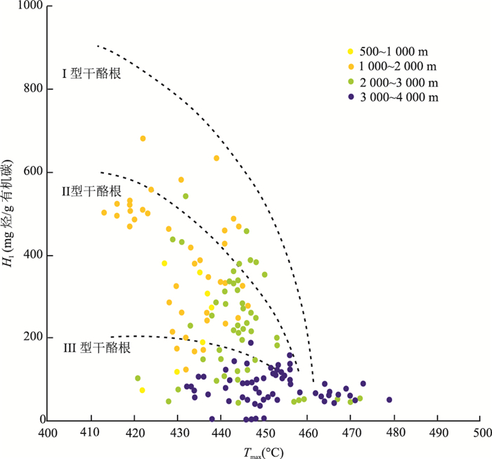
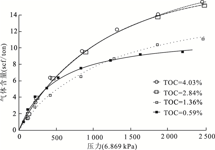
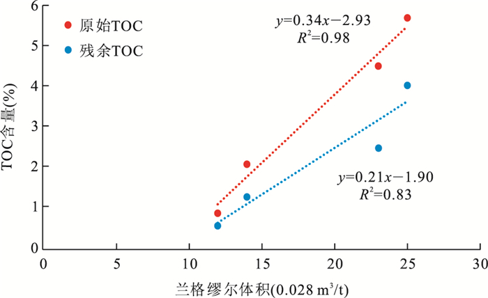
Total organic carbon (TOC) content is regarded as one of the important standards for shale oil and gas "sweet spot" prediction and potential resource evaluation. Taking Devonian Duvernay shale in West Canada sedimentary basin as an example, in this paper uses scanning electron microscope and methane adsorption measurements to discuss the weakness of using measured TOC as parameter for reservoir and gas capacity. Initial TOC was restored, and the measured and initial TOC vs. Langmuir volume was studied to reveal their difference as evaluation parameter. The result suggests that the difference between initial TOC and measured TOC varies significantly with the ratio ranging from 1.69-1.02, which increases with the thermal maturity. Thus, low measured TOC value doesn't represent low initial TOC value. Organic pore growth in Duvernay shale has no correlation with measured TOC, which means that the measured TOC is not the optical parameter to describe shale reservoir. Compared with measured TOC, Langmuir volume exhibits better correlations with initial ones, indicating initial TOC determines gas-adsorption behavior. Thus, in this paper it is evidenced to use initial TOC, rather than measured ones, as shale oil and gas evaluation parameters.
Total organic carbon (TOC) content is regarded as one of the important standards for shale oil and gas "sweet spot" prediction and potential resource evaluation. Taking Devonian Duvernay shale in West Canada sedimentary basin as an example, in this paper uses scanning electron microscope and methane adsorption measurements to discuss the weakness of using measured TOC as parameter for reservoir and gas capacity. Initial TOC was restored, and the measured and initial TOC vs. Langmuir volume was studied to reveal their difference as evaluation parameter. The result suggests that the difference between initial TOC and measured TOC varies significantly with the ratio ranging from 1.69-1.02, which increases with the thermal maturity. Thus, low measured TOC value doesn't represent low initial TOC value. Organic pore growth in Duvernay shale has no correlation with measured TOC, which means that the measured TOC is not the optical parameter to describe shale reservoir. Compared with measured TOC, Langmuir volume exhibits better correlations with initial ones, indicating initial TOC determines gas-adsorption behavior. Thus, in this paper it is evidenced to use initial TOC, rather than measured ones, as shale oil and gas evaluation parameters.


2019, 44(2): 513-523.
doi: 10.3799/dqkx.2018.556
Abstract:
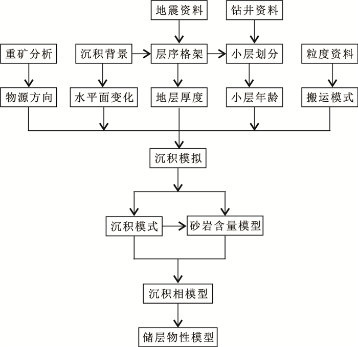
Due to the poor quality of seismic data and few wells, it is full of challenge to predict reservoir distribution in K oil field which is located at the south of Albert basin in Uganda. According to the comprehensive analyses of core, well logging, paleontology, heavy minerals and grain size, K oil field in Uganda is a shallow lake environment and developed near the source fan delta controlled by bounding fault. The direction of the sediment source located at southeast of this field and it was supplied by predominant distributary channel traction current in low energy and long term. On the basis of quantitative analysis of sedimentary impact factors, the quantified accommodation space variation, sedimentation supply and sediment transportation were put into sedimentary forward simulation under the control of chronostratigraphic framework to reconstruct stratigraphic evolution progress in geological history. Thus a three-dimension reservoir sand proportion distribution model was constructed to facilitate further understanding the spatial distribution characteristic of the sand in each zone. After transforming the results of sedimentary forward simulation into quantitative constraints for 3D geological modeling to control the facies model, a more accurate geological model which is consistent with the high accuracy of the sedimentary concept is established to predict and characterize the fan delta reservoir sand quantitatively.
Due to the poor quality of seismic data and few wells, it is full of challenge to predict reservoir distribution in K oil field which is located at the south of Albert basin in Uganda. According to the comprehensive analyses of core, well logging, paleontology, heavy minerals and grain size, K oil field in Uganda is a shallow lake environment and developed near the source fan delta controlled by bounding fault. The direction of the sediment source located at southeast of this field and it was supplied by predominant distributary channel traction current in low energy and long term. On the basis of quantitative analysis of sedimentary impact factors, the quantified accommodation space variation, sedimentation supply and sediment transportation were put into sedimentary forward simulation under the control of chronostratigraphic framework to reconstruct stratigraphic evolution progress in geological history. Thus a three-dimension reservoir sand proportion distribution model was constructed to facilitate further understanding the spatial distribution characteristic of the sand in each zone. After transforming the results of sedimentary forward simulation into quantitative constraints for 3D geological modeling to control the facies model, a more accurate geological model which is consistent with the high accuracy of the sedimentary concept is established to predict and characterize the fan delta reservoir sand quantitatively.


2019, 44(2): 551-558.
doi: 10.3799/dqkx.2018.351
Abstract:
The episodic hydrocarbon expulsion of overpressure basin is a hot issue in basin fluid research, there are few reports on hydrocarbon-bearing growth faults in source rocks. The study shows that the Qingshankou Formation, the main source rock of the central part of the Songliao basin, develops a hydrocarbon expulsion growth fault, these mid-shallow growth faults were formed at the end of the Nenjiang Formation to the end of the Mingshui Formation. When the excess pressure or overpressure of the source rock reached the bursting limit of the rock, the fractures appeared in the source rock or made the original fault open and grown, the hydrocarbon-bearing fluids were expelled towards the reservoirs either downward or upward, with the expulsion of hydrocarbons, the overpressure decreased gradually, the expelled process tended to be suspended and showed as the lower overpressure belt for the time being. When the source rock excess pressure reaches the source rock fracture limit, the source rock breaks or causes the original fault to start to grow again, the hydrocarbon-bearing fluid undergoes a hydrocarbon expulsion to the lower or upper reservoir, with the discharge of hydrocarbons, excessive pressure is decreasing. The hydrocarbon expulsion process tends to stop, with the release of overpressure fluid, the study area presents three types of hydrocarbons, hydrocarbons, upward hydrocarbons, and upper and lower hydrocarbons, since this hydrocarbon expulsion process occurs multiple times, with the repeated increase in hydrocarbon emissions, the fault distance of the hydrocarbon expulsion fault is also growing. Therefore, the hydrocarbon expulsion period has a good coupling relationship with the fault break growth period. The research results provide a new idea for oil and gas exploration in the upper and lower layers of the overpressure storage tank.
The episodic hydrocarbon expulsion of overpressure basin is a hot issue in basin fluid research, there are few reports on hydrocarbon-bearing growth faults in source rocks. The study shows that the Qingshankou Formation, the main source rock of the central part of the Songliao basin, develops a hydrocarbon expulsion growth fault, these mid-shallow growth faults were formed at the end of the Nenjiang Formation to the end of the Mingshui Formation. When the excess pressure or overpressure of the source rock reached the bursting limit of the rock, the fractures appeared in the source rock or made the original fault open and grown, the hydrocarbon-bearing fluids were expelled towards the reservoirs either downward or upward, with the expulsion of hydrocarbons, the overpressure decreased gradually, the expelled process tended to be suspended and showed as the lower overpressure belt for the time being. When the source rock excess pressure reaches the source rock fracture limit, the source rock breaks or causes the original fault to start to grow again, the hydrocarbon-bearing fluid undergoes a hydrocarbon expulsion to the lower or upper reservoir, with the discharge of hydrocarbons, excessive pressure is decreasing. The hydrocarbon expulsion process tends to stop, with the release of overpressure fluid, the study area presents three types of hydrocarbons, hydrocarbons, upward hydrocarbons, and upper and lower hydrocarbons, since this hydrocarbon expulsion process occurs multiple times, with the repeated increase in hydrocarbon emissions, the fault distance of the hydrocarbon expulsion fault is also growing. Therefore, the hydrocarbon expulsion period has a good coupling relationship with the fault break growth period. The research results provide a new idea for oil and gas exploration in the upper and lower layers of the overpressure storage tank.


2019, 44(2): 559-571.
doi: 10.3799/dqkx.2018.121
Abstract:
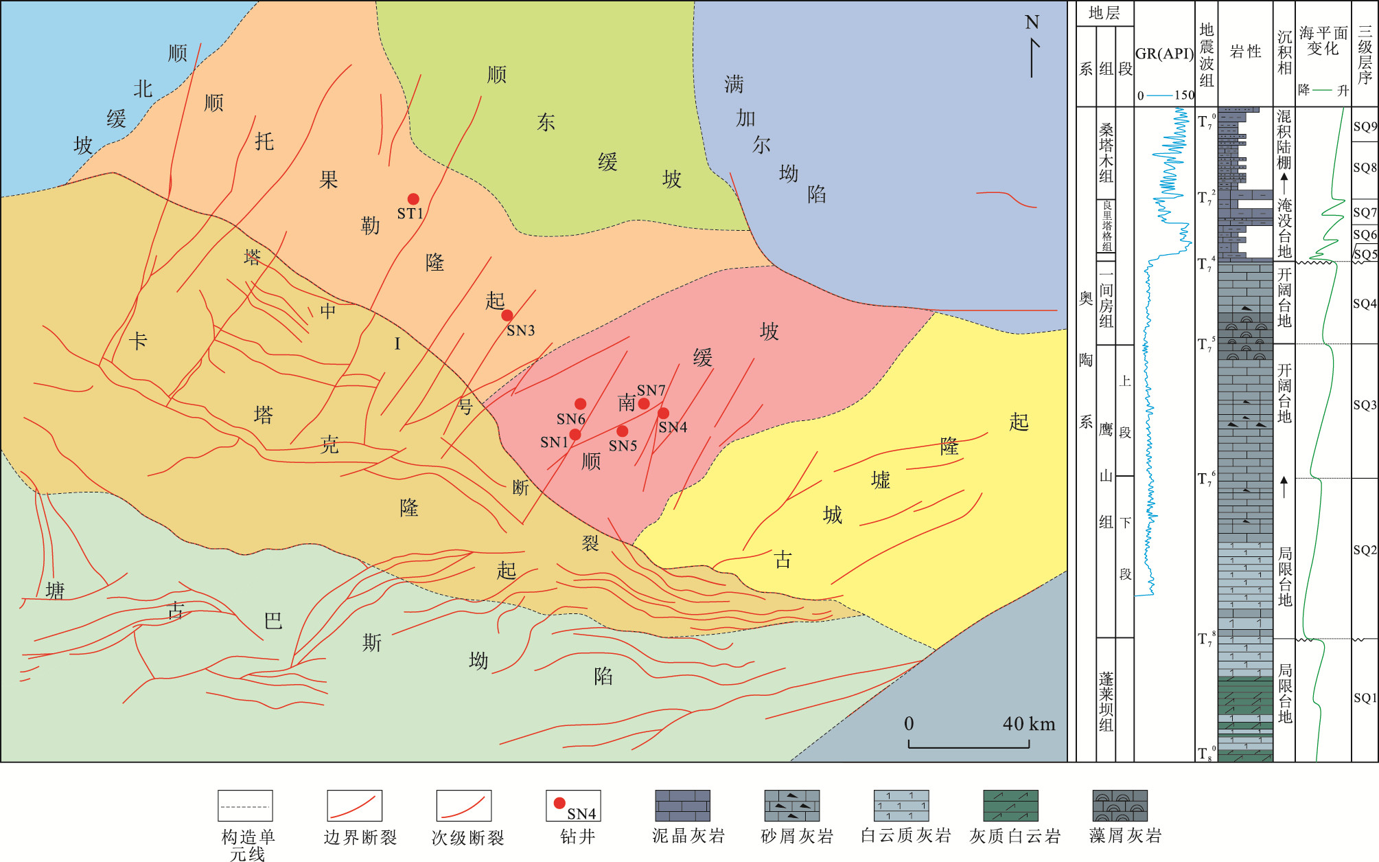
The microbial carbonate reservoir is one of the hot research areas.The observation of microbialite's core and casting thin sections of the northern slope of middle Tarim basin in our study shows that fracture-pore type reservoir dominates in the microbialites of study area. Though the porosity and permeability analysis of full diameter core, we found that the microbialites were good gas reservoirs. On the analysis of the formation mechanism and characteristics of microbialites, combined with stress sensitive experiment and imaging logging, we summarized the advantage factors of the forming reservoir space of microbialites, firstly, the generation of native dolomite can promote the dissolution of calcite. The microbialites of the study area experienced eogenetic karstification, and parts superposition late hypogenic karstification, improving the reservoir physical properties. Secondly, rich organic matter content not only caused dissolution by organic acid generated by microbialites in the burial diagenetic stage, but also reduced the ultimate strength of microbialites which could easy to form cracks under the tectonic movement. Therefore the reservoir space of microbialites in the northern slope of middle Tarim basin is mainly secondary role. Though the determination of rock compressibility, it is concluded that microbialites' compaction resistance is common, but algae crumbs skeleton is advantageous to the protection of the algal hole. The strongest ability to resist compaction is silicified microbialites, followed by dolomitization.
The microbial carbonate reservoir is one of the hot research areas.The observation of microbialite's core and casting thin sections of the northern slope of middle Tarim basin in our study shows that fracture-pore type reservoir dominates in the microbialites of study area. Though the porosity and permeability analysis of full diameter core, we found that the microbialites were good gas reservoirs. On the analysis of the formation mechanism and characteristics of microbialites, combined with stress sensitive experiment and imaging logging, we summarized the advantage factors of the forming reservoir space of microbialites, firstly, the generation of native dolomite can promote the dissolution of calcite. The microbialites of the study area experienced eogenetic karstification, and parts superposition late hypogenic karstification, improving the reservoir physical properties. Secondly, rich organic matter content not only caused dissolution by organic acid generated by microbialites in the burial diagenetic stage, but also reduced the ultimate strength of microbialites which could easy to form cracks under the tectonic movement. Therefore the reservoir space of microbialites in the northern slope of middle Tarim basin is mainly secondary role. Though the determination of rock compressibility, it is concluded that microbialites' compaction resistance is common, but algae crumbs skeleton is advantageous to the protection of the algal hole. The strongest ability to resist compaction is silicified microbialites, followed by dolomitization.


2019, 44(2): 572-587.
doi: 10.3799/dqkx.2017.618
Abstract:
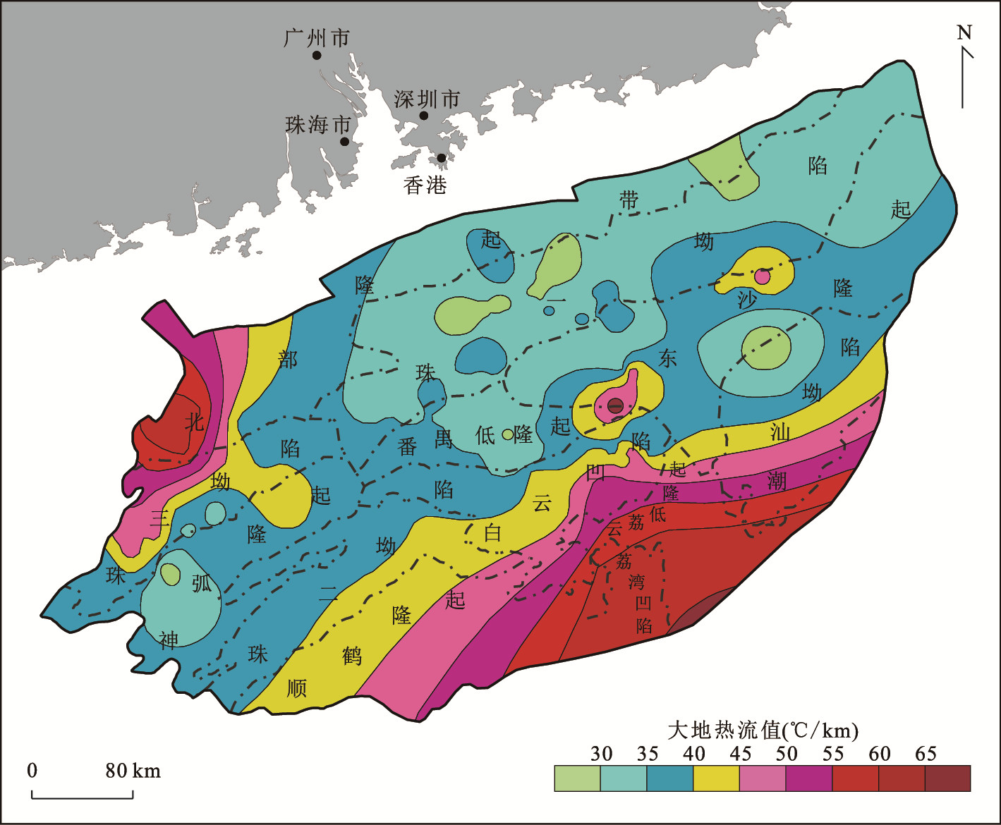
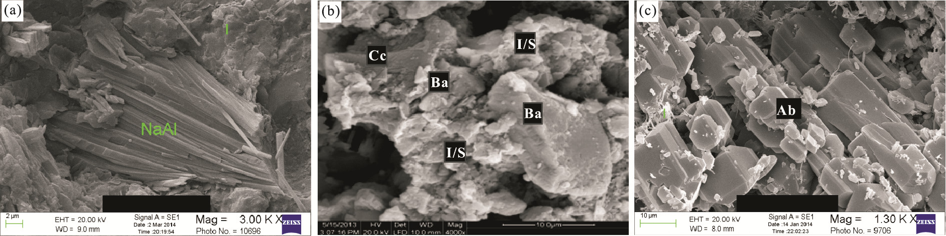
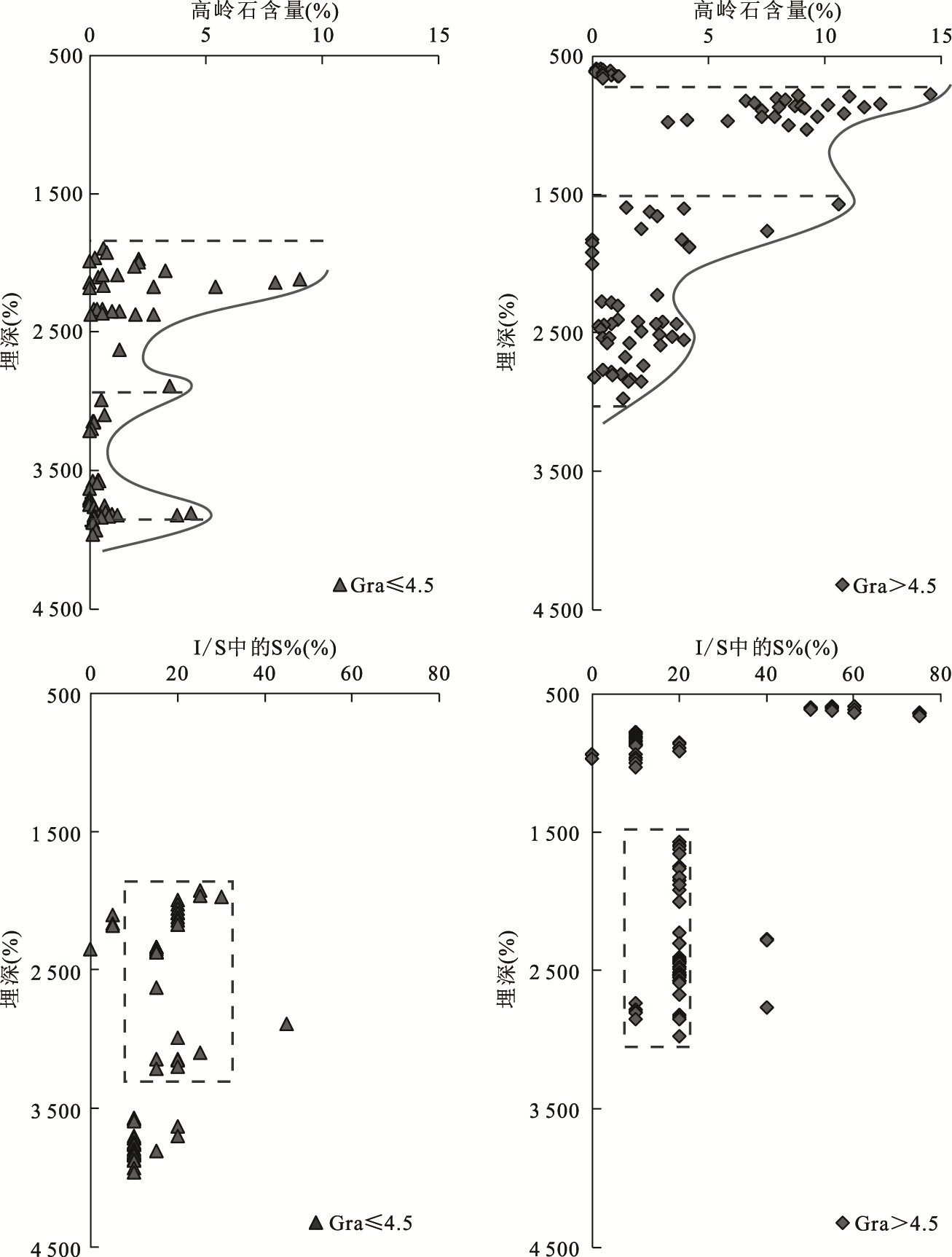
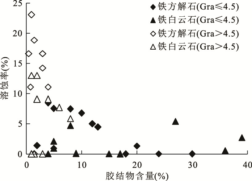
Baiyun sag, located in Pearl River Mouth basin, South China Sea, is regarded as the major region for oil-gas research and exploration in deepwater area in China. The current heat flow of Pearl River Mouth basin is from 24.2 to 121.0 mW/m2, and the maximum geothermal gradient of single well is measured as 6.64℃/100 m, which proves that the basin is hot. The governing factor of the basin evolution was transformed from fault to fault-thermal collectively during the post-breakup subsidence stage, especially after the generation of the Baiyun movement (23.8 Ma). Since then, the thermal effect is known as one of the crucial elements in controlling the diagenetic evolution of the sedimentary strata in Baiyun sag, which is demonstrated by some petrological and heating records in sedimentary layer, such as the vitrinite reflectance, the homogenization temperatures of secondary fluid inclusions in sandstone and the authigenic minerals of hydrothermal genesis. Baiyun sag can be divided into low geothermal gradient region (LGR, Gra ≤ 4.5℃/100 m) and high geothermal gradient region(HGR, Gra>4.5℃/100 m). Analytical results of observation of casting thin sections, electron microscope scanning, and X-ray diffraction analysis, show the differences between these two regions in diagenetic processes of sandstone in Zhuhai Formation. (1) The compaction of sandstone in LGR is controlled mainly by lithostatic effect, while in HGR it is controlled by both thermal and lithostatic effect so that the isoporosity limit buried depth is more shallow than that in LGR. (2) The increase of heating rate accelerates the transformation progress of clay minerals in stratum, the depth that indicates the vanishment of the kaolinite in HGR is more shallow than that in LGR, and the ordering process of I/S (illite/smectite mixed layer) in HGR is more mature than that in LGR. (3) Deep-sourced fluid is involved in the diagenetic processes of sandstone in Zhuhai Formation in HGR, which is influenced by the tectonic heating event obviously, so that the thermal equilibrium of dissolution-precipitation of carbonate minerals is changed. The exchange process in interstitial water of the stratum is complex and active, and the authigenic hydrothermal minerals are produced in this process.
Baiyun sag, located in Pearl River Mouth basin, South China Sea, is regarded as the major region for oil-gas research and exploration in deepwater area in China. The current heat flow of Pearl River Mouth basin is from 24.2 to 121.0 mW/m2, and the maximum geothermal gradient of single well is measured as 6.64℃/100 m, which proves that the basin is hot. The governing factor of the basin evolution was transformed from fault to fault-thermal collectively during the post-breakup subsidence stage, especially after the generation of the Baiyun movement (23.8 Ma). Since then, the thermal effect is known as one of the crucial elements in controlling the diagenetic evolution of the sedimentary strata in Baiyun sag, which is demonstrated by some petrological and heating records in sedimentary layer, such as the vitrinite reflectance, the homogenization temperatures of secondary fluid inclusions in sandstone and the authigenic minerals of hydrothermal genesis. Baiyun sag can be divided into low geothermal gradient region (LGR, Gra ≤ 4.5℃/100 m) and high geothermal gradient region(HGR, Gra>4.5℃/100 m). Analytical results of observation of casting thin sections, electron microscope scanning, and X-ray diffraction analysis, show the differences between these two regions in diagenetic processes of sandstone in Zhuhai Formation. (1) The compaction of sandstone in LGR is controlled mainly by lithostatic effect, while in HGR it is controlled by both thermal and lithostatic effect so that the isoporosity limit buried depth is more shallow than that in LGR. (2) The increase of heating rate accelerates the transformation progress of clay minerals in stratum, the depth that indicates the vanishment of the kaolinite in HGR is more shallow than that in LGR, and the ordering process of I/S (illite/smectite mixed layer) in HGR is more mature than that in LGR. (3) Deep-sourced fluid is involved in the diagenetic processes of sandstone in Zhuhai Formation in HGR, which is influenced by the tectonic heating event obviously, so that the thermal equilibrium of dissolution-precipitation of carbonate minerals is changed. The exchange process in interstitial water of the stratum is complex and active, and the authigenic hydrothermal minerals are produced in this process.


2019, 44(2): 524-538.
doi: 10.3799/dqkx.2018.515
Abstract:
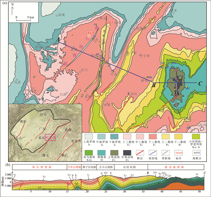
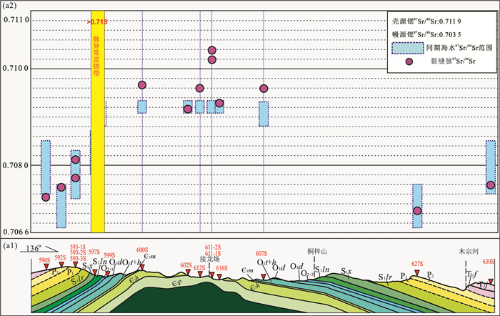
The development of the differential tectonic zones in the Jiaoshiba-Wulong area with complex paleo-fluid activities is crucial to the preservation of shale gas. The fracture veins of two typical anticlines (steep anticlines and box anticlines) are studied. Based on the theory of fractal fracture and carbon, oxygen and strontium isotope geochemistry, it reveals the differences of paleo-fluid activities in different structure and coupling of shale gas preservation conditions. The study suggests fellows:(1) There is coupling between tectonic deformation and paleo-fluid activity. The fluid is more active in the tectonic stress concentration areas (such as box anticlinal hinge, hidden faults) than other parts of the structure. (2) There is coupling between paleo-fluid tracer differences and shale gas preservation conditions. Isotope geochemistry reveals that the internal fluid flow dominates in the Permian-Lower Triassic formation, and the sealing ability is good. The Wufeng-Longmaxi shale gas of the high-steep anticline in the basin and the residual syncline outside the basin has certain exploration prospects. There exists the trace of cross-layer fluid activities in the Middle Cambrian-Lower Ordovician formation, and the sealing ability deteriorates. The risks of shale gas exploration in the Lower Cambrian Qiongzhusi Formation of the box anticline outside the basin increased.
The development of the differential tectonic zones in the Jiaoshiba-Wulong area with complex paleo-fluid activities is crucial to the preservation of shale gas. The fracture veins of two typical anticlines (steep anticlines and box anticlines) are studied. Based on the theory of fractal fracture and carbon, oxygen and strontium isotope geochemistry, it reveals the differences of paleo-fluid activities in different structure and coupling of shale gas preservation conditions. The study suggests fellows:(1) There is coupling between tectonic deformation and paleo-fluid activity. The fluid is more active in the tectonic stress concentration areas (such as box anticlinal hinge, hidden faults) than other parts of the structure. (2) There is coupling between paleo-fluid tracer differences and shale gas preservation conditions. Isotope geochemistry reveals that the internal fluid flow dominates in the Permian-Lower Triassic formation, and the sealing ability is good. The Wufeng-Longmaxi shale gas of the high-steep anticline in the basin and the residual syncline outside the basin has certain exploration prospects. There exists the trace of cross-layer fluid activities in the Middle Cambrian-Lower Ordovician formation, and the sealing ability deteriorates. The risks of shale gas exploration in the Lower Cambrian Qiongzhusi Formation of the box anticline outside the basin increased.


2019, 44(2): 539-550.
doi: 10.3799/dqkx.2018.182
Abstract:
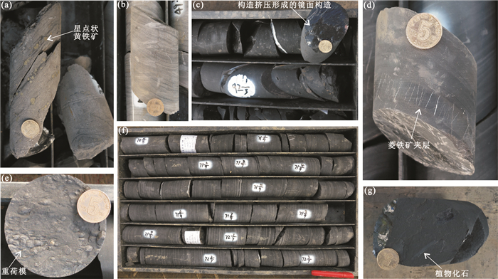
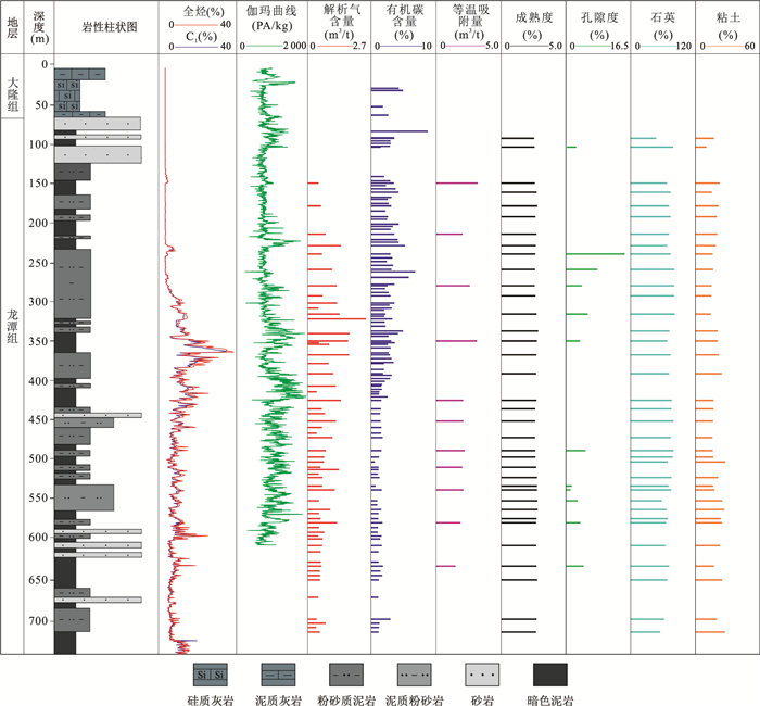
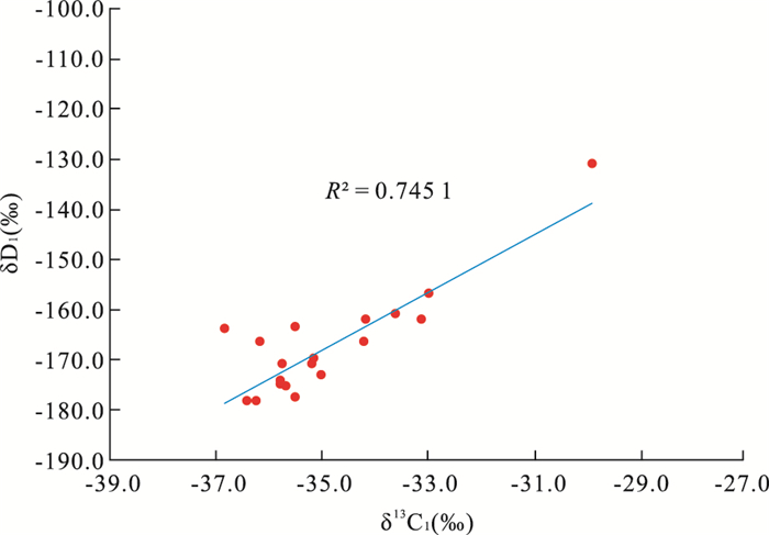
In order to evaluate shale gas resources potential in the Permian Longtan Formation, Shaoyang sag, Central Hunan, a shale gas survey well-2015H-D3 was done in this study. The gas-bearing properties and its influencing factors were quantitatively analyzed by the well on-site desorption with other related tests, combined with gas stable carbon and hydrogen isotopes, preliminary discussion on the origin of hydrocarbon gas is made. The gas logging values become abnormal from the depth of 150 m, and the gas content of desorption firstly increases gradually and then decreases with the increase of depth. 300-425 m is the highest gas-bearing zone, with a cumulative thickness of 125 m. The gas content of desorption is all over 0.5 m3/t, the highest value is 2.35 m3/t, with an average value of 1 m3/t, indicating that the Longtan Formation has a good potential for shale gas exploration. The gas content of desorption is controlled by organic carbon content while the depth is more than 300 m, and the desorption gas content is not simply constrained by organic carbon content but rather restricted by the preservation conditions while the buried depth is less than 300 m. The gas carbon isotope test shows that δ13C1 is between -29.87‰ and -36.82‰ with the average value of -34.52‰, δ13C2 is between -29.45‰ and -31.02‰ with the average value of -30.09‰, and δD1 is between -131.2‰ and -178.4‰ with the average value of -167.4‰. The gas origin analysis reveals that the shale gas in Longtan Formation belongs to the type of oil source gas in thermal genesis. It can be determined that the Longtan Formation is the transitional environment through sedimentary phenomena, which is consistent with the results of hydrogen isotope, but it is still unable to determine the specific judgment interval.
In order to evaluate shale gas resources potential in the Permian Longtan Formation, Shaoyang sag, Central Hunan, a shale gas survey well-2015H-D3 was done in this study. The gas-bearing properties and its influencing factors were quantitatively analyzed by the well on-site desorption with other related tests, combined with gas stable carbon and hydrogen isotopes, preliminary discussion on the origin of hydrocarbon gas is made. The gas logging values become abnormal from the depth of 150 m, and the gas content of desorption firstly increases gradually and then decreases with the increase of depth. 300-425 m is the highest gas-bearing zone, with a cumulative thickness of 125 m. The gas content of desorption is all over 0.5 m3/t, the highest value is 2.35 m3/t, with an average value of 1 m3/t, indicating that the Longtan Formation has a good potential for shale gas exploration. The gas content of desorption is controlled by organic carbon content while the depth is more than 300 m, and the desorption gas content is not simply constrained by organic carbon content but rather restricted by the preservation conditions while the buried depth is less than 300 m. The gas carbon isotope test shows that δ13C1 is between -29.87‰ and -36.82‰ with the average value of -34.52‰, δ13C2 is between -29.45‰ and -31.02‰ with the average value of -30.09‰, and δD1 is between -131.2‰ and -178.4‰ with the average value of -167.4‰. The gas origin analysis reveals that the shale gas in Longtan Formation belongs to the type of oil source gas in thermal genesis. It can be determined that the Longtan Formation is the transitional environment through sedimentary phenomena, which is consistent with the results of hydrogen isotope, but it is still unable to determine the specific judgment interval.


2019, 44(2): 588-602.
doi: 10.3799/dqkx.2018.205
Abstract:
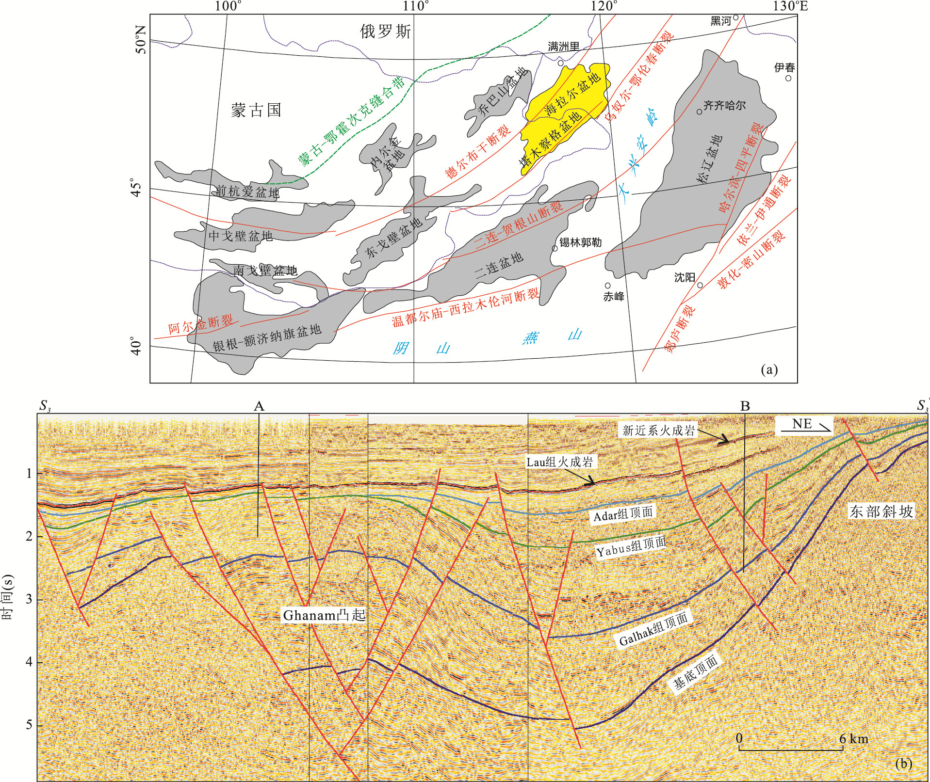
Melut Basin is an important petroliferous passive rift basin of Central Africa, and now it is in the midst of transformation from negional structure exploration to new formations, new domains and new areas exploration without very clear understandings of hydrocarbon accumulation. By analogy between Melut passive rift basin and active rift basins of East China, the geological understandings of hydrocarbon accumulation in Melut Basin are deepened, and the exploration transformation will be promoted. The analogy shows that, the North Melut Sub-basin has typical passive rift basin character, and developed large oil-rich sag with the primary "far-source" play of Paleogene and secondary "near-source" play of Cretaceous. The "far-source" lithological reservoir of Upper Yabus Fm. in Paleogene and Cretaceous faulted block reservoirs of Galhak Fm. near source rock are two important domains of fine exploration in North Melut Sub-basin. The Central-South Melut Sub-basins experienced overlapping tectonic evolution process of passive and active rift basin, with the sediments filling and play features of small faulted depression, which is similar with the Hailar Basin, and the "near-source" reservoir-caprock assemblages are favorable exploration targets, inherited low uplifts in sags, faulted uplifts between sags, and faulted slope break belts in gentle slope are favorable hydrocarbon accumulation structural zones. The study deepens the understandings of hydrocarbon accumulation in Melut Basin, and it is suggested that the North and Central-South Melut Sub-basins have different basin forming mechanisms and hydrocarbon accumulation characteristics, which is of great importance to promote the fine exploration in mature exploration areas of North Melut Sub-basin and exploration breakthrough in low exploration areas of Central-South Melut Sub-basins.
Melut Basin is an important petroliferous passive rift basin of Central Africa, and now it is in the midst of transformation from negional structure exploration to new formations, new domains and new areas exploration without very clear understandings of hydrocarbon accumulation. By analogy between Melut passive rift basin and active rift basins of East China, the geological understandings of hydrocarbon accumulation in Melut Basin are deepened, and the exploration transformation will be promoted. The analogy shows that, the North Melut Sub-basin has typical passive rift basin character, and developed large oil-rich sag with the primary "far-source" play of Paleogene and secondary "near-source" play of Cretaceous. The "far-source" lithological reservoir of Upper Yabus Fm. in Paleogene and Cretaceous faulted block reservoirs of Galhak Fm. near source rock are two important domains of fine exploration in North Melut Sub-basin. The Central-South Melut Sub-basins experienced overlapping tectonic evolution process of passive and active rift basin, with the sediments filling and play features of small faulted depression, which is similar with the Hailar Basin, and the "near-source" reservoir-caprock assemblages are favorable exploration targets, inherited low uplifts in sags, faulted uplifts between sags, and faulted slope break belts in gentle slope are favorable hydrocarbon accumulation structural zones. The study deepens the understandings of hydrocarbon accumulation in Melut Basin, and it is suggested that the North and Central-South Melut Sub-basins have different basin forming mechanisms and hydrocarbon accumulation characteristics, which is of great importance to promote the fine exploration in mature exploration areas of North Melut Sub-basin and exploration breakthrough in low exploration areas of Central-South Melut Sub-basins.


2019, 44(2): 603-625.
doi: 10.3799/dqkx.2018.542
Abstract:
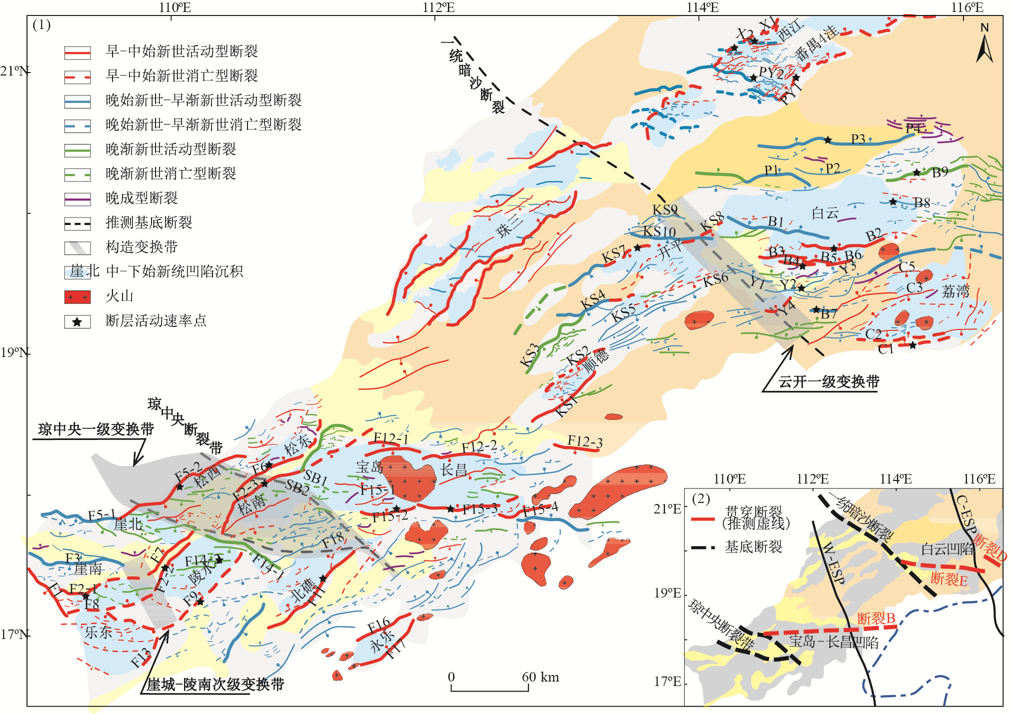
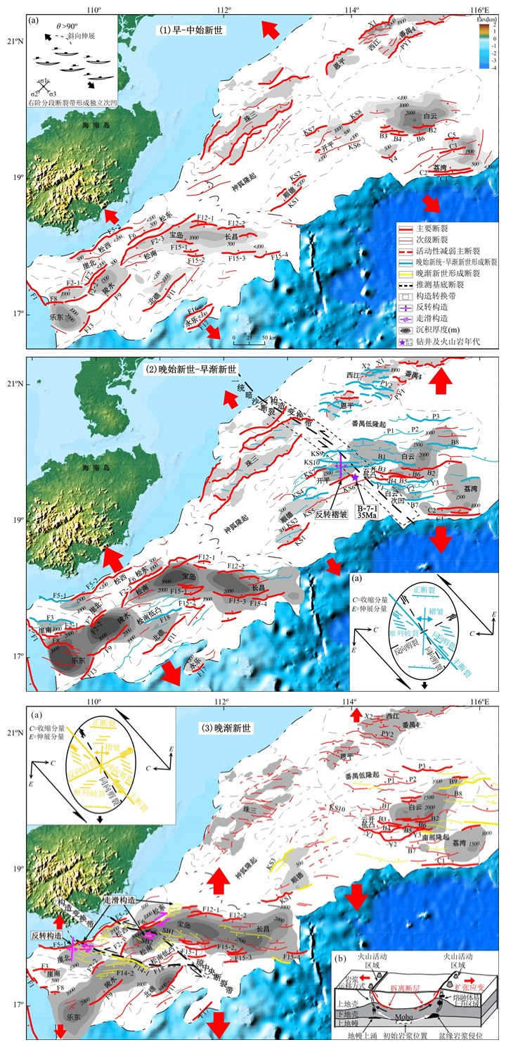
We employ recently updated seismic reflection data to investigate spatial-temporal difference of Cenozoic faults systems and its dynamic mechanism of the Pearl River Mouth Basin and Qiongdongnan Basin in the Northern of South China Sea.It shows geometry, kinematics of extensional faults systems in the Paleogene rift zone of the Pearl River Mouth basin and Qiongdongnan basin change significantly along strike, which is composed of NE-and EW-trending normal basement faults.The concealed regional and local NW-trending faults with associated deformation zone constitute the transfer zones between the extensional faults systems.The "non-detachment" extensional fault system consists of NE-and NEE-trending normal faults to the west of NW-trending Yunkai and Songtao-Songnan transfer zones, and the detachment fault system is composed of NE-and EW-trending normal/strile-slip faults to the east.Paleogene rifting experienced three distinguished stages.In the early period (Wenchang Formation), simple (half) grabens in western basins was controlled by planar normal faults with relatively small extension, and composite (half) grabens in eastern basins are dominated by listric normal faults with large extension, where normal faults converge and terminate at detachment fault within mid-crust.In the middle period (Enping/Yacheng Formation), faults in the west are characterized by inherited activity, whereas NWW-and EW-trending faults in the east of Pearl River Mouth Basin form deep detachment system by cutting antecedent mid-crust detachment fault, with inversion along the Yunkai transfer zone.In the late stage (Zhuhai/Lingshui Formation), the activities of faults decline in the west, whereas NWW-and EW-trending faults form deep detachment system in the east of the Qiongdongnan Basin, with inversion and strike-slip structures along the Songtao-Songnan transfer zone.The influencing factors of differential fault systems and tectonic evolution include pre-existing basement fabrics, rheology of crust and lithosphere, and extension amount.The detachment systems are associated with the NWW-trending throughgoing crustal faults within basement weak belts and present local crustal thinning zone, the geodynamic mechanisms for differential extension on both sides of the transfer zones result from the strike-slip movement along the NWW-trending pre-existing faults induced by the opening of the South China Sea from east to west, and changes of the stress field and lithospheric thermal structure account for the depth variation of the detachment systems.
We employ recently updated seismic reflection data to investigate spatial-temporal difference of Cenozoic faults systems and its dynamic mechanism of the Pearl River Mouth Basin and Qiongdongnan Basin in the Northern of South China Sea.It shows geometry, kinematics of extensional faults systems in the Paleogene rift zone of the Pearl River Mouth basin and Qiongdongnan basin change significantly along strike, which is composed of NE-and EW-trending normal basement faults.The concealed regional and local NW-trending faults with associated deformation zone constitute the transfer zones between the extensional faults systems.The "non-detachment" extensional fault system consists of NE-and NEE-trending normal faults to the west of NW-trending Yunkai and Songtao-Songnan transfer zones, and the detachment fault system is composed of NE-and EW-trending normal/strile-slip faults to the east.Paleogene rifting experienced three distinguished stages.In the early period (Wenchang Formation), simple (half) grabens in western basins was controlled by planar normal faults with relatively small extension, and composite (half) grabens in eastern basins are dominated by listric normal faults with large extension, where normal faults converge and terminate at detachment fault within mid-crust.In the middle period (Enping/Yacheng Formation), faults in the west are characterized by inherited activity, whereas NWW-and EW-trending faults in the east of Pearl River Mouth Basin form deep detachment system by cutting antecedent mid-crust detachment fault, with inversion along the Yunkai transfer zone.In the late stage (Zhuhai/Lingshui Formation), the activities of faults decline in the west, whereas NWW-and EW-trending faults form deep detachment system in the east of the Qiongdongnan Basin, with inversion and strike-slip structures along the Songtao-Songnan transfer zone.The influencing factors of differential fault systems and tectonic evolution include pre-existing basement fabrics, rheology of crust and lithosphere, and extension amount.The detachment systems are associated with the NWW-trending throughgoing crustal faults within basement weak belts and present local crustal thinning zone, the geodynamic mechanisms for differential extension on both sides of the transfer zones result from the strike-slip movement along the NWW-trending pre-existing faults induced by the opening of the South China Sea from east to west, and changes of the stress field and lithospheric thermal structure account for the depth variation of the detachment systems.


2019, 44(2): 626-639.
doi: 10.3799/dqkx.2018.136
Abstract:
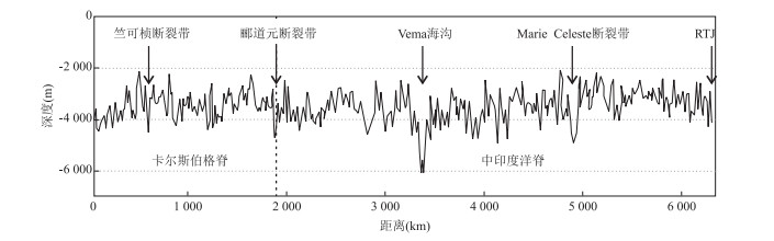
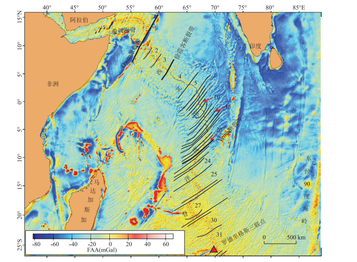
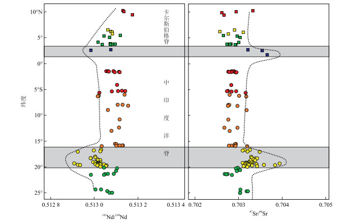
The existing nomenclatures for the ridge system of Northwest Indian Ocean include Carlsberg Ridge and Central Indian Ridge from north to south. The demarcation point between them is thought to be the intersection of Australia-Indian plate boundary and the ridge axis, which is yet poorly constrained. Based on the current knowledge of geological, geophysical and geochemical investigation and research results of the whole ridge segment, a new terminology for the ridge system of Northwest Indian Ocean is proposed, i.e. the Northwest Indian Ridge (NWIR). The whole ridge extends from Rodrigues Triple Junction to Owen transform fault, which includes Carlsberg Ridge and Central Indian Ridge, no matter where the boundary is. The new term may promote the thorough recognition of evolution history of Northwest Indian Ridge, as well as its geodynamic process. The Northwest Indian Ridge is especially full of faults in the middle segment but less on both ends, just like the shape of a straw and its bend is an analog for the turning point of the ridge. The gravity anomaly shows that the magma supplies at both ends are relatively abundant, while the magma in the middle part is rather limited. The magnetic anomaly in the Northwest Indian Ocean is zonated and indicates a multi-stage ridge spreading processes. Besides, the most prominent feature in petrogeochemistry is the presence of relatively isotopically enriched ridge basalts from two ridge segments, which may be related to the hotspot intervention and/or contamination of depleted asthenosphere by residual lithosphere or crustal materials.
The existing nomenclatures for the ridge system of Northwest Indian Ocean include Carlsberg Ridge and Central Indian Ridge from north to south. The demarcation point between them is thought to be the intersection of Australia-Indian plate boundary and the ridge axis, which is yet poorly constrained. Based on the current knowledge of geological, geophysical and geochemical investigation and research results of the whole ridge segment, a new terminology for the ridge system of Northwest Indian Ocean is proposed, i.e. the Northwest Indian Ridge (NWIR). The whole ridge extends from Rodrigues Triple Junction to Owen transform fault, which includes Carlsberg Ridge and Central Indian Ridge, no matter where the boundary is. The new term may promote the thorough recognition of evolution history of Northwest Indian Ridge, as well as its geodynamic process. The Northwest Indian Ridge is especially full of faults in the middle segment but less on both ends, just like the shape of a straw and its bend is an analog for the turning point of the ridge. The gravity anomaly shows that the magma supplies at both ends are relatively abundant, while the magma in the middle part is rather limited. The magnetic anomaly in the Northwest Indian Ocean is zonated and indicates a multi-stage ridge spreading processes. Besides, the most prominent feature in petrogeochemistry is the presence of relatively isotopically enriched ridge basalts from two ridge segments, which may be related to the hotspot intervention and/or contamination of depleted asthenosphere by residual lithosphere or crustal materials.


2019, 44(2): 640-651.
doi: 10.3799/dqkx.2018.516
Abstract:
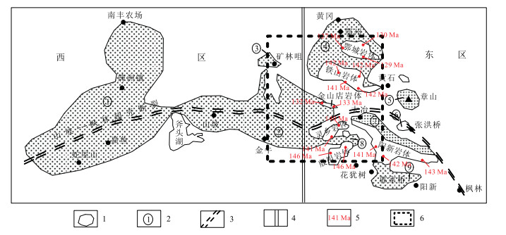
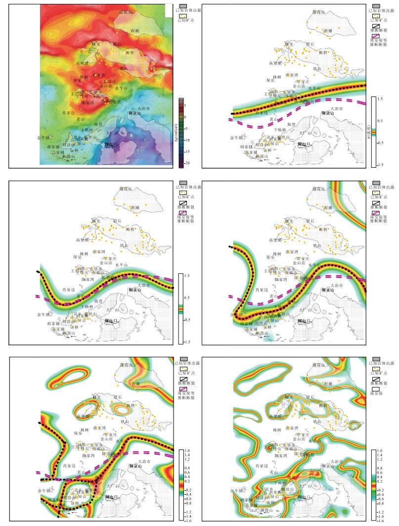
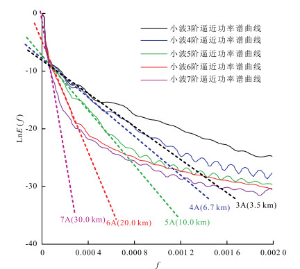
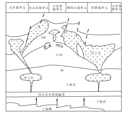
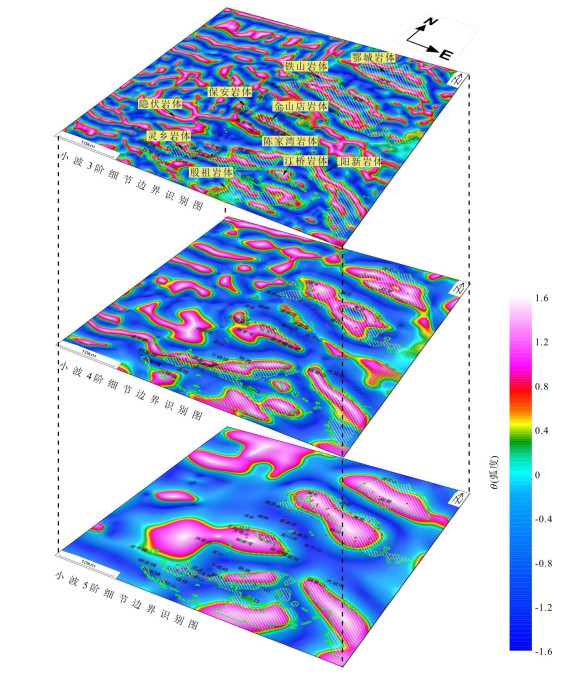
In this paper, wavelet multi-scale analysis/boundary identification method/continuous complex wavelet time-frequency analysis/3D magnetization inversion are used to process and interpret gravity and magnetic data in the southeast Hubei Province. It is found the follows. (1)The Shanpo-Fenglin deeply-penetrating fault is north dipping and shallow part shows shape of "S", of which middle-western section deviates to south and east section deviates to north as a result of transformation in Indo-Chinese epoch and Yanshanian. It has controlled the formation and distribution of rock mass in Indo-Chinese epoch and Yanshanian. Echeng/Tieshan/Jinshandian/Lingxiang rock masses are dominated by iron ore on the north. Yangxin/Yinzu/Guojiaqiao rock masses are dominated by copper polymetallic ore on the south. (2) Magma chamber is located in deep, with a depth of about 5 km. Magma intruded upward and emplaced through weakness structure, which formed mid-shallow and exposed rock mass in the shape of bead/apophyses/dike. (3) There may exist concealed ore body in south of Echeng rock mass/north of Tieshan rock mass/east part of the south margin of Jinshandian rock mass. The areas where Chenjiawan exposed rock mass/Jinniu-Xiaojiabian exposed rock mass/west of Lingxiang exposed rock mass are in contact with carbonate beds are favourable for mineralization.
In this paper, wavelet multi-scale analysis/boundary identification method/continuous complex wavelet time-frequency analysis/3D magnetization inversion are used to process and interpret gravity and magnetic data in the southeast Hubei Province. It is found the follows. (1)The Shanpo-Fenglin deeply-penetrating fault is north dipping and shallow part shows shape of "S", of which middle-western section deviates to south and east section deviates to north as a result of transformation in Indo-Chinese epoch and Yanshanian. It has controlled the formation and distribution of rock mass in Indo-Chinese epoch and Yanshanian. Echeng/Tieshan/Jinshandian/Lingxiang rock masses are dominated by iron ore on the north. Yangxin/Yinzu/Guojiaqiao rock masses are dominated by copper polymetallic ore on the south. (2) Magma chamber is located in deep, with a depth of about 5 km. Magma intruded upward and emplaced through weakness structure, which formed mid-shallow and exposed rock mass in the shape of bead/apophyses/dike. (3) There may exist concealed ore body in south of Echeng rock mass/north of Tieshan rock mass/east part of the south margin of Jinshandian rock mass. The areas where Chenjiawan exposed rock mass/Jinniu-Xiaojiabian exposed rock mass/west of Lingxiang exposed rock mass are in contact with carbonate beds are favourable for mineralization.


2019, 44(2): 652-663.
doi: 10.3799/dqkx.2018.212
Abstract:
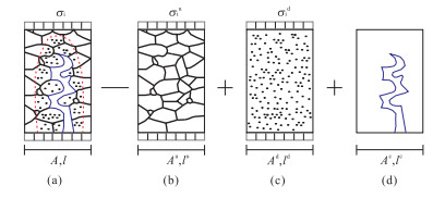
Aiming at the limitations of previous rock damage constitutive models, a comprehensive simulation method of rock deformation to present simultaneously initial damage and residual strength is developed. With consideration of the initial damage of rock and the fact that the damage portion still can bear certain stress, deformation mechanism models of each portion are established by decomposing rock materials into three portions, undamaged material, damaged material and micro-defects. Firstly, on the basis of geometry conditions and micro-force for rocks, the strain analysis for undamaged material is proposed. Meanwhile, considering that the deformation energy of rock is only related to damaged material, the strain analysis for damaged material is developed. Then, discussing the relationships between damage evolution and energy dissipation, and putting forward a damage evolution model to reflect the initial damage for rocks, a rock damage constitutive model to simulate the complete processes of deformation for rocks is established based on the strain analysis and the determination methods of model parameters are also provided. The results show that damage evolution model not only reflects the initial damage for rocks, but also presents the rock deformation stages. Compared with previous models, the proposed damage constitutive model is more consistent with the experimental curve. In addition, the proposed model reflects the complete processes of deformation for rocks, and presents intuitively the characteristics of the initial damage and the residual strength. Thus, the superiority of the model is validated.
Aiming at the limitations of previous rock damage constitutive models, a comprehensive simulation method of rock deformation to present simultaneously initial damage and residual strength is developed. With consideration of the initial damage of rock and the fact that the damage portion still can bear certain stress, deformation mechanism models of each portion are established by decomposing rock materials into three portions, undamaged material, damaged material and micro-defects. Firstly, on the basis of geometry conditions and micro-force for rocks, the strain analysis for undamaged material is proposed. Meanwhile, considering that the deformation energy of rock is only related to damaged material, the strain analysis for damaged material is developed. Then, discussing the relationships between damage evolution and energy dissipation, and putting forward a damage evolution model to reflect the initial damage for rocks, a rock damage constitutive model to simulate the complete processes of deformation for rocks is established based on the strain analysis and the determination methods of model parameters are also provided. The results show that damage evolution model not only reflects the initial damage for rocks, but also presents the rock deformation stages. Compared with previous models, the proposed damage constitutive model is more consistent with the experimental curve. In addition, the proposed model reflects the complete processes of deformation for rocks, and presents intuitively the characteristics of the initial damage and the residual strength. Thus, the superiority of the model is validated.


2019, 44(2): 664-676.
doi: 10.3799/dqkx.2018.175
Abstract:
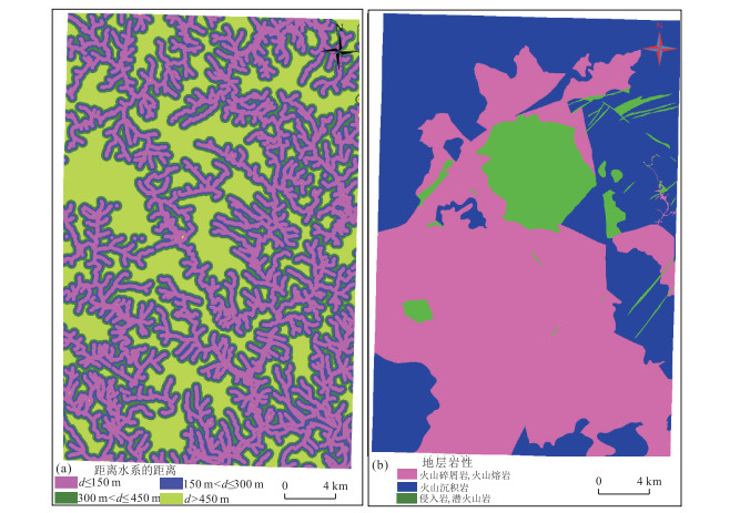
Statistical and machine learning models, such as support vector machine (SVM), have been widely used to assess the landslide susceptibility. However, the modeling processes of statistical and machine learning model are generally complex.For example, it is difficult to select reasonable non-landslide grid cells when the machine learning models are trained and tested, and many model parameters need to be determined.In order to improve the efficiency and accuracy of the model used for landslide susceptibility assessment, the grey relational degree (GRD) model is proposed. The GRD model can efficiently calculate the quantitative relational degrees between the comparative samples and the reference sample, and it has the advantages of simple modeling process and accurate assessment results.However, few studies have been done on the GRD model.In this study, the GRD model is used to assess the landslide susceptibility in the Nantian and Yamei maps (Nantian area) in the Feiyunjiang River basin, Zhejiang Province of China, and the assessment results of the GRD model are compared with those of the SVM model. The results show that the GRD model has higher prediction rate than the SVM model in the high and very high susceptibility areas, and has slightly lower prediction rate than the SVM in the moderate susceptibility area. On the whole, the GRD model has slightly higher prediction rate than the SVM for landslide susceptibility assessment in Nantian area. Meanwhile, the results also show that the model process of GRD is simple, it has higher efficiency than the SVM. The GRD model provides a novel idea for landslide susceptibility assessment.
Statistical and machine learning models, such as support vector machine (SVM), have been widely used to assess the landslide susceptibility. However, the modeling processes of statistical and machine learning model are generally complex.For example, it is difficult to select reasonable non-landslide grid cells when the machine learning models are trained and tested, and many model parameters need to be determined.In order to improve the efficiency and accuracy of the model used for landslide susceptibility assessment, the grey relational degree (GRD) model is proposed. The GRD model can efficiently calculate the quantitative relational degrees between the comparative samples and the reference sample, and it has the advantages of simple modeling process and accurate assessment results.However, few studies have been done on the GRD model.In this study, the GRD model is used to assess the landslide susceptibility in the Nantian and Yamei maps (Nantian area) in the Feiyunjiang River basin, Zhejiang Province of China, and the assessment results of the GRD model are compared with those of the SVM model. The results show that the GRD model has higher prediction rate than the SVM model in the high and very high susceptibility areas, and has slightly lower prediction rate than the SVM in the moderate susceptibility area. On the whole, the GRD model has slightly higher prediction rate than the SVM for landslide susceptibility assessment in Nantian area. Meanwhile, the results also show that the model process of GRD is simple, it has higher efficiency than the SVM. The GRD model provides a novel idea for landslide susceptibility assessment.


2019, 44(2): 677-684.
doi: 10.3799/dqkx.2018.195
Abstract:
Taken Maliulin landslide as a case, the friction angle, cohesive strength, hydraulic conductivity, immersion ratio, reservoir drawdown rate and rainfall are chosen as influential factors and orthogonal experiment was carried out. Sensitivity analysis was performed using range analysis.Results show that the stability of Maliulin landslide is mainly influenced by its self-factors, and the reservoir and rainfall have limited impact on landslide stability. Landslide stability is most sensitive to friction angle, followed by hydraulic conductivity, cohesive strength and immersion ratio. The initial landslide stability is mainly influenced by friction angle and cohesive strength. As the decreasing of immersion ratio, the landslide stability has limited increase. The changed ratio of factor of safety is mainly influenced by hydraulic conductivity in which a critical value K0 existed. When hydraulic conductivity is greater than K0, the landslide stability increases with the increasing of permeability coefficient. On the contrary, the landslide stability decreases with the decreasing of hydraulic conductivity when hydraulic conductivity is less than K0.
Taken Maliulin landslide as a case, the friction angle, cohesive strength, hydraulic conductivity, immersion ratio, reservoir drawdown rate and rainfall are chosen as influential factors and orthogonal experiment was carried out. Sensitivity analysis was performed using range analysis.Results show that the stability of Maliulin landslide is mainly influenced by its self-factors, and the reservoir and rainfall have limited impact on landslide stability. Landslide stability is most sensitive to friction angle, followed by hydraulic conductivity, cohesive strength and immersion ratio. The initial landslide stability is mainly influenced by friction angle and cohesive strength. As the decreasing of immersion ratio, the landslide stability has limited increase. The changed ratio of factor of safety is mainly influenced by hydraulic conductivity in which a critical value K0 existed. When hydraulic conductivity is greater than K0, the landslide stability increases with the increasing of permeability coefficient. On the contrary, the landslide stability decreases with the decreasing of hydraulic conductivity when hydraulic conductivity is less than K0.