2019 Vol. 44, No. 3
Display Method:
 PDF 313KB
2019, 44(3): 685-697.
doi: 10.3799/dqkx.2019.007
Abstract:
Various isotope geochronometers have their specific dating objects (minerals or whole rocks) and age ranges.It is difficult to date the ages of hydrothermal deposits.To solve this problem, the 40Ar/39Ar progressive crushing technique to date the ages of fluid inclusions is established.This technique has been improved and developed for thirty years, widely applied to determine the forming ages of hydrothermal deposits, metamorphic rocks and quartz veins, as well as the natural gas fields in deep Songliao Basin.In this article, the experimental techniques of fluid inclusion extraction and gas purification are introduced in detail, followed by the important applications in hydrothermal deposits and gas/oil fields as illustrations of 40Ar/39Ar dating by the stepwise crushing technique.The gas-mixing patterns yielded by crushing are also discussed.
Various isotope geochronometers have their specific dating objects (minerals or whole rocks) and age ranges.It is difficult to date the ages of hydrothermal deposits.To solve this problem, the 40Ar/39Ar progressive crushing technique to date the ages of fluid inclusions is established.This technique has been improved and developed for thirty years, widely applied to determine the forming ages of hydrothermal deposits, metamorphic rocks and quartz veins, as well as the natural gas fields in deep Songliao Basin.In this article, the experimental techniques of fluid inclusion extraction and gas purification are introduced in detail, followed by the important applications in hydrothermal deposits and gas/oil fields as illustrations of 40Ar/39Ar dating by the stepwise crushing technique.The gas-mixing patterns yielded by crushing are also discussed.


2019, 44(3): 698-712.
doi: 10.3799/dqkx.2019.958
Abstract:
Basin fluid is the most active geological agent in sedimentary basins, having a close relationship with the generation, migration and accumulation of hydrocarbon resources.Accurate determination of fluid flow history has been a challenging and frontier research topic.In general, the previous studies of basin fluids mainly rely on the analysis of fluid inclusions, which is difficult to successfully reconstruct the events of basin fluids.More seriously, this method is unable to determine the timing of fluid flow events.Authigenic calcite is the direct product of basin fluids.Thus, accurate dating of authigenic calcite provides a new approach to determine the history of fluid flow events.In the field of calcite geochronology, the most widely used dating method was the isotope dilution U-Pb dating approach.However, this approach is time-consuming, and has a low success rate.In recent years, laser ablation technology has greatly facilitated U-Pb dating of accessory minerals (including calcite) because of its high spatial resolution and rapid data acquisition.It has been confirmed that the newly-developed in-situ U-Pb dating method is able to accurately determine the age of calcite with U content less than 10×10-9.This method has successfully reconstructed the history of fluid flow events in the sedimentary basins, suggesting that it has a good application prospect in the field of basin fluid geochronology.In the future, it can be expected that the application of in-situ U-Pb dating of calcite together with C-O isotope and rare earth element analysis will be a significant development direction in the field of basin fluid studies.It is worth noting that the determination of stage of authigenic calcite through systematic microscopic identification and diagenetic observation is the premise of application success.
Basin fluid is the most active geological agent in sedimentary basins, having a close relationship with the generation, migration and accumulation of hydrocarbon resources.Accurate determination of fluid flow history has been a challenging and frontier research topic.In general, the previous studies of basin fluids mainly rely on the analysis of fluid inclusions, which is difficult to successfully reconstruct the events of basin fluids.More seriously, this method is unable to determine the timing of fluid flow events.Authigenic calcite is the direct product of basin fluids.Thus, accurate dating of authigenic calcite provides a new approach to determine the history of fluid flow events.In the field of calcite geochronology, the most widely used dating method was the isotope dilution U-Pb dating approach.However, this approach is time-consuming, and has a low success rate.In recent years, laser ablation technology has greatly facilitated U-Pb dating of accessory minerals (including calcite) because of its high spatial resolution and rapid data acquisition.It has been confirmed that the newly-developed in-situ U-Pb dating method is able to accurately determine the age of calcite with U content less than 10×10-9.This method has successfully reconstructed the history of fluid flow events in the sedimentary basins, suggesting that it has a good application prospect in the field of basin fluid geochronology.In the future, it can be expected that the application of in-situ U-Pb dating of calcite together with C-O isotope and rare earth element analysis will be a significant development direction in the field of basin fluid studies.It is worth noting that the determination of stage of authigenic calcite through systematic microscopic identification and diagenetic observation is the premise of application success.

2019, 44(3): 713-726.
doi: 10.3799/dqkx.2018.383
Abstract:
The Neoproterozoic-Cambrian reservoir in the Sichuan Basin, which has stored more than one trillion cubic meters of petroleum, is an important exploration target in China.However, the complex tectonism and accumulation conditions limited the detail analysis of their hydrocarbon evolution.Recently, the isotope dating methods, like 40Ar-40Ar dating on the hydrocarbon bearing fluid inclusions and the Re-Os dating on the crude oil and bitumen, have shown good potential on constraining the key times of the petroleum system evolutions.Based on the previous understanding on the Neoproterozoic-Cambrian reservoir evolution, and integrating the bitumen Re-Os dating results on the Weiyuan gas field, the Kuangshanliang paleo-reservoir in the West Sichuan Basin and the Micang Shan paleo-reservoir in the North Sichuan Basin, this study indicates that the Neoproterozoic-Cambrian petroleum system experienced oil type reservoir formation during Caledonian (~450 Ma) and both oil and dry gas type reservoir formation during Indosinian-Yanshanian event (ca.205-162 Ma).In addition, this study also puts forward some key problems related to the Re-Os analysis on accurate constraining petroleum evolution according to our current understanding.In summary, the hydrocarbon Re-Os geochronology is helpful for the development of the petroleum geochronology and could promote the understanding of the evolution and mechanism of the deep buried marine petroleum systems.
The Neoproterozoic-Cambrian reservoir in the Sichuan Basin, which has stored more than one trillion cubic meters of petroleum, is an important exploration target in China.However, the complex tectonism and accumulation conditions limited the detail analysis of their hydrocarbon evolution.Recently, the isotope dating methods, like 40Ar-40Ar dating on the hydrocarbon bearing fluid inclusions and the Re-Os dating on the crude oil and bitumen, have shown good potential on constraining the key times of the petroleum system evolutions.Based on the previous understanding on the Neoproterozoic-Cambrian reservoir evolution, and integrating the bitumen Re-Os dating results on the Weiyuan gas field, the Kuangshanliang paleo-reservoir in the West Sichuan Basin and the Micang Shan paleo-reservoir in the North Sichuan Basin, this study indicates that the Neoproterozoic-Cambrian petroleum system experienced oil type reservoir formation during Caledonian (~450 Ma) and both oil and dry gas type reservoir formation during Indosinian-Yanshanian event (ca.205-162 Ma).In addition, this study also puts forward some key problems related to the Re-Os analysis on accurate constraining petroleum evolution according to our current understanding.In summary, the hydrocarbon Re-Os geochronology is helpful for the development of the petroleum geochronology and could promote the understanding of the evolution and mechanism of the deep buried marine petroleum systems.


2019, 44(3): 727-737.
doi: 10.3799/dqkx.2019.006
Abstract:
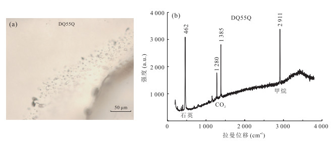
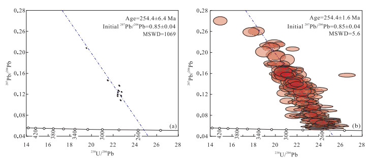
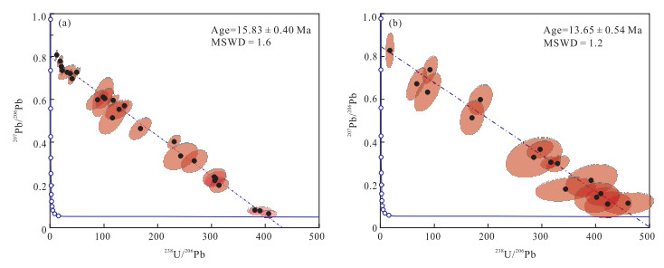
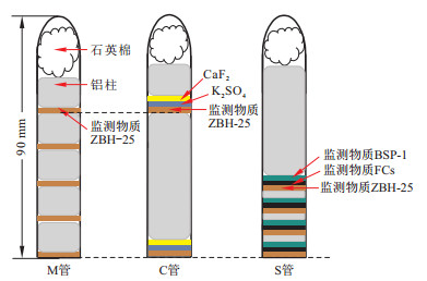
The domestic reactors which could be utilized for the irradiation of 40Ar-39Ar dating samples are not only rare but the operation frequency is very low, which makes the period of the irradiation for samples extremely long.Besides, the optimized parameters of irradiation for different kinds of samples are short of systematic research.To solve the above-mentioned problems, primary research was done on the HFETR in the application of the irradiation of 40Ar-39Ar dating samples for the first time.Through the irradiation of certain amount of biotite standard ZBH-25, the production efficiency of 39ArK is determined, which could provide the basis for the irradiation time for samples with different ages or potassium contents.The axial neutron flux gradient of the irradiation channel, which shows approximative conic function (R2>0.99), is only 3.3%/cm.However, the radial flux gradient is much more obvious, which is as high as 7.1%/cm.The interference factors are determined through the irradiation of pure potassium salt and calcium salt.It is found that the (36Ar/37Ar)Ca factor is uniform with the value (3.52±0.11)×10-4, but the interference factors (40Ar/39Ar)K and (36Ar/37Ar)Ca are scattered at different positions of the irradiation channel.The shielding effect of cadmium for the decrease of the interference factor of (40Ar/39Ar)K is prominent at the bottom of the sample vessel but negligible at the top of the sample vessel, which may result from the difference of the neutron spectrum along the axial direction of the irradiation channel.Taking the international standard sanidine FCs as neutron flux monitor, the domestic standards biotite ZBH-25 and hornblende BSP-1 are dated.Excellent plateau age is obtained for the ZBH-25 biotite standard, indicating that the HFETR could satisfy the requirement of the sample irradiation.However, the precision and accuracy of the plateau age of the BSP-1 hornblende is somewhat worse, which maybe has something to do with the relatively old age and low ratio of the K/Ca.Precise determination of the interference factors and proloning of the irradiation time are necessary for the improvement of the age quality for such kind of sample.
The domestic reactors which could be utilized for the irradiation of 40Ar-39Ar dating samples are not only rare but the operation frequency is very low, which makes the period of the irradiation for samples extremely long.Besides, the optimized parameters of irradiation for different kinds of samples are short of systematic research.To solve the above-mentioned problems, primary research was done on the HFETR in the application of the irradiation of 40Ar-39Ar dating samples for the first time.Through the irradiation of certain amount of biotite standard ZBH-25, the production efficiency of 39ArK is determined, which could provide the basis for the irradiation time for samples with different ages or potassium contents.The axial neutron flux gradient of the irradiation channel, which shows approximative conic function (R2>0.99), is only 3.3%/cm.However, the radial flux gradient is much more obvious, which is as high as 7.1%/cm.The interference factors are determined through the irradiation of pure potassium salt and calcium salt.It is found that the (36Ar/37Ar)Ca factor is uniform with the value (3.52±0.11)×10-4, but the interference factors (40Ar/39Ar)K and (36Ar/37Ar)Ca are scattered at different positions of the irradiation channel.The shielding effect of cadmium for the decrease of the interference factor of (40Ar/39Ar)K is prominent at the bottom of the sample vessel but negligible at the top of the sample vessel, which may result from the difference of the neutron spectrum along the axial direction of the irradiation channel.Taking the international standard sanidine FCs as neutron flux monitor, the domestic standards biotite ZBH-25 and hornblende BSP-1 are dated.Excellent plateau age is obtained for the ZBH-25 biotite standard, indicating that the HFETR could satisfy the requirement of the sample irradiation.However, the precision and accuracy of the plateau age of the BSP-1 hornblende is somewhat worse, which maybe has something to do with the relatively old age and low ratio of the K/Ca.Precise determination of the interference factors and proloning of the irradiation time are necessary for the improvement of the age quality for such kind of sample.


2019, 44(3): 738-755.
doi: 10.3799/dqkx.2018.335
Abstract:
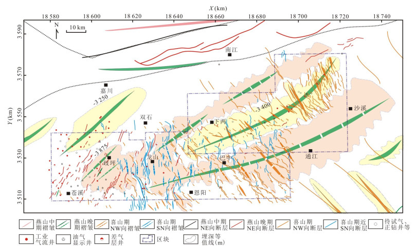
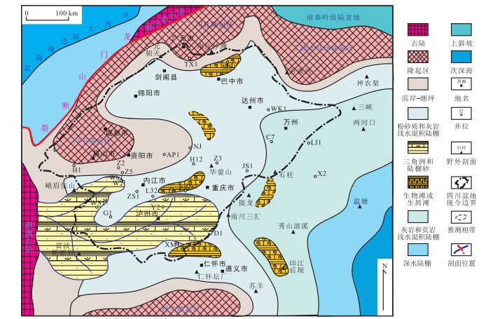
There are many different opinions on Sinian-Early Cambrian tectonic-sedimentary evolution in Sichuan Basin.Based on the previous studies, the latest seismic, drilling and outcrop data and the sedimentary evolution characteristics of Sinian-Early Cambrian tectonics in Sichuan Basin are discussed systematically.The analysis shows that the Sichuan Basin has a structural framework with alternative depressions and upheavals before the deposition of Doushantuo Formation.The high point of the Hannan ancient land structure continued migration to the northeast in the sedimentary period of Doushantuo to Early Cambrian.The Kaijiang-Xuanhan ancient uplift in the first and second phase of Dengying Formation sedimentary period is the main developing period, and the top of the ancient uplift may be no longer covered by water.During the third and fourth phase of Dengying Formation sedimentary period, the development of the ancient uplift decreased and turned into the underwater uplift.In the Early Cambrian period, it merged with the ancient uplift in central Sichuan.Based on the analysis of the well connection profile, typical well element logging, field outcrop characteristics and previous research results, our analysis suggests that there is deep-water deposit in the Deyang-Anyue ancient rifting during the third and fourth phase of Dengying Formation sedimentary period.On this basis, the development pattern of ancient rifting is summarized.The Deyang-Anyue ancient rifting has obvious characteristics of multiple stages of development.The edge of the ancient rifting continues to move northeast, the edge of the ancient rifting of the second phase of Dengying Formation sedimentary period is located in the Shuangtan area, while the edge of the ancient rifting of the fourth phase is located in the west of Yuanba.At the same time, the ancient rifting has the development characteristics of "early in the north and late in the south, first fault depression second depression".The ancient rifting developed from the middle to the north of Sichuan during the sedimentary period of Dengying Formation and had the development characteristics of fault depression.In Early Cambrian, the ancient rifting changed into depression, and the South Sichuan area began to develop on a large scale, the edge of the ancient rifting continues to move northeast in the middle to the north of Sichuan.The hydrocarbon source rock of Qiongzhusi Formation was developed as a result of transformation of Yuanba-Renhechang-Malubei area into deep water deposits in northern Sichuan Basin.By the end of the Early Cambrian, the ancient rift had died out and was filled up.
There are many different opinions on Sinian-Early Cambrian tectonic-sedimentary evolution in Sichuan Basin.Based on the previous studies, the latest seismic, drilling and outcrop data and the sedimentary evolution characteristics of Sinian-Early Cambrian tectonics in Sichuan Basin are discussed systematically.The analysis shows that the Sichuan Basin has a structural framework with alternative depressions and upheavals before the deposition of Doushantuo Formation.The high point of the Hannan ancient land structure continued migration to the northeast in the sedimentary period of Doushantuo to Early Cambrian.The Kaijiang-Xuanhan ancient uplift in the first and second phase of Dengying Formation sedimentary period is the main developing period, and the top of the ancient uplift may be no longer covered by water.During the third and fourth phase of Dengying Formation sedimentary period, the development of the ancient uplift decreased and turned into the underwater uplift.In the Early Cambrian period, it merged with the ancient uplift in central Sichuan.Based on the analysis of the well connection profile, typical well element logging, field outcrop characteristics and previous research results, our analysis suggests that there is deep-water deposit in the Deyang-Anyue ancient rifting during the third and fourth phase of Dengying Formation sedimentary period.On this basis, the development pattern of ancient rifting is summarized.The Deyang-Anyue ancient rifting has obvious characteristics of multiple stages of development.The edge of the ancient rifting continues to move northeast, the edge of the ancient rifting of the second phase of Dengying Formation sedimentary period is located in the Shuangtan area, while the edge of the ancient rifting of the fourth phase is located in the west of Yuanba.At the same time, the ancient rifting has the development characteristics of "early in the north and late in the south, first fault depression second depression".The ancient rifting developed from the middle to the north of Sichuan during the sedimentary period of Dengying Formation and had the development characteristics of fault depression.In Early Cambrian, the ancient rifting changed into depression, and the South Sichuan area began to develop on a large scale, the edge of the ancient rifting continues to move northeast in the middle to the north of Sichuan.The hydrocarbon source rock of Qiongzhusi Formation was developed as a result of transformation of Yuanba-Renhechang-Malubei area into deep water deposits in northern Sichuan Basin.By the end of the Early Cambrian, the ancient rift had died out and was filled up.


2019, 44(3): 756-772.
doi: 10.3799/dqkx.2019.032
Abstract:
Most of the non-marine tight sandstone strata in the polycyclic superimposed basins in China is rich in hydrocarbon resources and exhibits complicated and specific hydrocarbon geological characteristics.Yuanba-Tongnanba area is located in a polycyclic and multi-attribute tectonic intersection.It is a typical region which could reveal the respond relationship between multiphase tectonization and non-marine tight gas accumulation in the polycyclic superimposed basin.Based on the seismic data, apatite fission track (AFT) geochronology and hydrocarbon accumulation characterizes analysis, two critical tectonic periods have been identified which are the Late Yanshan epoch (Late Cretaceous about 100-70 Ma) and the Early Himalayan epoch (Eocene to Olgocene about 40-25 Ma).The gas accumulation in the non-marine tight sandstone reservoirs was controlled by the tectonization of two critical tectonic periods.NE-trending structures were built in the Late Yanshan epoch which is the critical hydrocarbon accumulation period of NE-trending weak deformation zone, NW-SN trending transitional deformation belt (the west area of Tongnanba block) and NW-trending concentrated deformation belt.The respond pattern of Late Yanshan epoch could be expressed as earlier accumulation, terrestrial source, anticline control response on gas trap and fold control response on fractures.NW-trending and nearly SN-trending structures were built in the Early Himalayan epoch which is not only the critical hydrocarbon accumulation period of SN-trending transitional deformation belt and NW-SN trending transitional deformation belt (the east area of Yuanba block), but also the critical hydrocarbon reconstruction period of NW-SN trending transitional deformation belt (the west area of Tongnanba block) and NW-trending concentrated deformation belt.The respond pattern of Himalayan epoch could be expressed as late accumulation, marine-terrestrial mixed source, fault control response on gas trap and fault control response on fractures.
Most of the non-marine tight sandstone strata in the polycyclic superimposed basins in China is rich in hydrocarbon resources and exhibits complicated and specific hydrocarbon geological characteristics.Yuanba-Tongnanba area is located in a polycyclic and multi-attribute tectonic intersection.It is a typical region which could reveal the respond relationship between multiphase tectonization and non-marine tight gas accumulation in the polycyclic superimposed basin.Based on the seismic data, apatite fission track (AFT) geochronology and hydrocarbon accumulation characterizes analysis, two critical tectonic periods have been identified which are the Late Yanshan epoch (Late Cretaceous about 100-70 Ma) and the Early Himalayan epoch (Eocene to Olgocene about 40-25 Ma).The gas accumulation in the non-marine tight sandstone reservoirs was controlled by the tectonization of two critical tectonic periods.NE-trending structures were built in the Late Yanshan epoch which is the critical hydrocarbon accumulation period of NE-trending weak deformation zone, NW-SN trending transitional deformation belt (the west area of Tongnanba block) and NW-trending concentrated deformation belt.The respond pattern of Late Yanshan epoch could be expressed as earlier accumulation, terrestrial source, anticline control response on gas trap and fold control response on fractures.NW-trending and nearly SN-trending structures were built in the Early Himalayan epoch which is not only the critical hydrocarbon accumulation period of SN-trending transitional deformation belt and NW-SN trending transitional deformation belt (the east area of Yuanba block), but also the critical hydrocarbon reconstruction period of NW-SN trending transitional deformation belt (the west area of Tongnanba block) and NW-trending concentrated deformation belt.The respond pattern of Himalayan epoch could be expressed as late accumulation, marine-terrestrial mixed source, fault control response on gas trap and fault control response on fractures.


2019, 44(3): 773-783.
doi: 10.3799/dqkx.2018.293
Abstract:
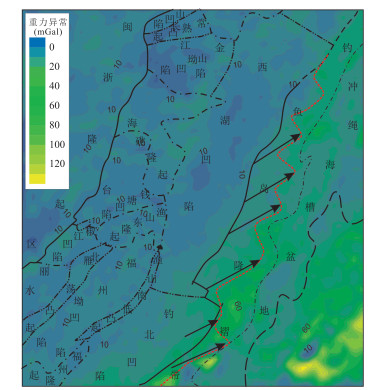
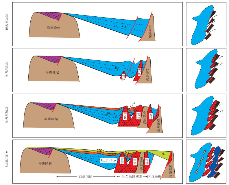
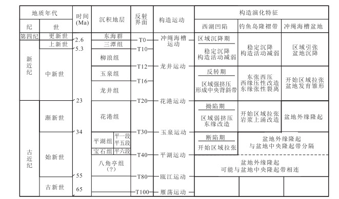
The restoration of Paleogene prototype basin is a key problem related to the study of sedimentary system and hydrocarbon accumulation of Huagang Formation and Pinghu Formation in the main exploration strata in Xihu Sag, whereas a reasonable understanding of the structural evolution of Diaoyu Islands folded zone in the east margin of Xihu Sag is the key to the problem.However, relevant studies are often limited by the weak data base of the research area.In this paper a breakthrough in the geological understanding through the comprehensive analysis of gravity, magnetic and seismic data innovatively is obtained.It is believed that in the early stage the Diaoyu Islands folded zone was part of the "East China Sea shelf outer margin uplift" and underwent intense magmatic hyperplasia in the later stage.Structurally, the part under the T20 interface in the folded zone is mainly composed of ancient metamorphic basement, magmatic rock mass and residual sag filling layer.The residual sag and strata in the folded zone are characterized by NE-trending and enechel on distribution.These strata are mainly Eocene Pinghu Formation deposited before Oligocene magmatic hyperplasia and transformation, and are the residual part of the eastern margin of the Paleogene prototype basin of Xihu Sag.The eastern boundary of the Paleogene prototype basin of Xihu Sag is located in the current Diaoyu Islands folded zone, and is a series of NE-trending faults in enechel on distribution, and there are different types of transition between faults.In the process of magmatic proliferation in the Diaoyu Islands folded zone, the rock mass upwelling along the boundary fault "submerged" the boundary of the prototype basin.The strata in the eastern margin of the prototype basin underwent large-scale uplift and denudation, and the original structural appearance and morphology were greatly changed.
The restoration of Paleogene prototype basin is a key problem related to the study of sedimentary system and hydrocarbon accumulation of Huagang Formation and Pinghu Formation in the main exploration strata in Xihu Sag, whereas a reasonable understanding of the structural evolution of Diaoyu Islands folded zone in the east margin of Xihu Sag is the key to the problem.However, relevant studies are often limited by the weak data base of the research area.In this paper a breakthrough in the geological understanding through the comprehensive analysis of gravity, magnetic and seismic data innovatively is obtained.It is believed that in the early stage the Diaoyu Islands folded zone was part of the "East China Sea shelf outer margin uplift" and underwent intense magmatic hyperplasia in the later stage.Structurally, the part under the T20 interface in the folded zone is mainly composed of ancient metamorphic basement, magmatic rock mass and residual sag filling layer.The residual sag and strata in the folded zone are characterized by NE-trending and enechel on distribution.These strata are mainly Eocene Pinghu Formation deposited before Oligocene magmatic hyperplasia and transformation, and are the residual part of the eastern margin of the Paleogene prototype basin of Xihu Sag.The eastern boundary of the Paleogene prototype basin of Xihu Sag is located in the current Diaoyu Islands folded zone, and is a series of NE-trending faults in enechel on distribution, and there are different types of transition between faults.In the process of magmatic proliferation in the Diaoyu Islands folded zone, the rock mass upwelling along the boundary fault "submerged" the boundary of the prototype basin.The strata in the eastern margin of the prototype basin underwent large-scale uplift and denudation, and the original structural appearance and morphology were greatly changed.


2019, 44(3): 784-797.
doi: 10.3799/dqkx.2018.109
Abstract:
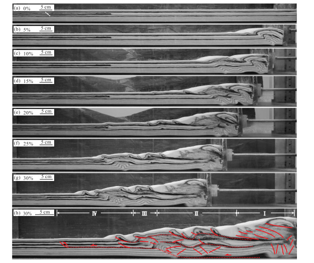
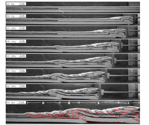
Jura-type folds are well-developed in the eastern Sichuan fold-thrust belt, which are separated into two areas with different structural styles by the northeast-trending Qiyueshan fault, ejective folds to the northwest and trough-like folds to the southeast.The tectonic deformation of the Mesozoic intra-continental structural belt is progressive from southeast to northwest and controlled by multiple detachment layers which are the basement decollement horizon, lower-Cambrian shale, Silurian shale and Triassic gypsum-rock, respectively.However, there is still much controversy about the formation mechanism of the eastern Sichuan fold belt and its overall and segmentation formation time.Based on tectonic physical simulation, we reproduced the formation of the Jura-type folds in eastern Sichuan and analyzed the influence of pre-existing fault and fault dips on the tectonic deformation of the eastern Sichuan fold belt.The simulation results show that the eastern Sichuan fold belt is the product of fault-related folding caused by tectonic extrusion in the step system composed of Qiyueshan fault, Huayingshan fault, basement decollement horizon and Silurian detachment layer.The basement decollement horizon (depth of~16 km) results in trough-like folds, while the Silurian shale leads to ejective folds.The structural shortening rate of Mesozoic (about 165-75 Ma) in eastern Sichuan is about 32%.The Qiyueshan fault is an important hinge for the transition from trough-like folds to ejective folds, and is the product of migration of the shallow part of this high-angle fault to the northwest.The steep-dipping Huayingshan fault determines the wavelength of folds, favoring the development of typical ejective folds.
Jura-type folds are well-developed in the eastern Sichuan fold-thrust belt, which are separated into two areas with different structural styles by the northeast-trending Qiyueshan fault, ejective folds to the northwest and trough-like folds to the southeast.The tectonic deformation of the Mesozoic intra-continental structural belt is progressive from southeast to northwest and controlled by multiple detachment layers which are the basement decollement horizon, lower-Cambrian shale, Silurian shale and Triassic gypsum-rock, respectively.However, there is still much controversy about the formation mechanism of the eastern Sichuan fold belt and its overall and segmentation formation time.Based on tectonic physical simulation, we reproduced the formation of the Jura-type folds in eastern Sichuan and analyzed the influence of pre-existing fault and fault dips on the tectonic deformation of the eastern Sichuan fold belt.The simulation results show that the eastern Sichuan fold belt is the product of fault-related folding caused by tectonic extrusion in the step system composed of Qiyueshan fault, Huayingshan fault, basement decollement horizon and Silurian detachment layer.The basement decollement horizon (depth of~16 km) results in trough-like folds, while the Silurian shale leads to ejective folds.The structural shortening rate of Mesozoic (about 165-75 Ma) in eastern Sichuan is about 32%.The Qiyueshan fault is an important hinge for the transition from trough-like folds to ejective folds, and is the product of migration of the shallow part of this high-angle fault to the northwest.The steep-dipping Huayingshan fault determines the wavelength of folds, favoring the development of typical ejective folds.


2019, 44(3): 798-809.
doi: 10.3799/dqkx.2018.338
Abstract:
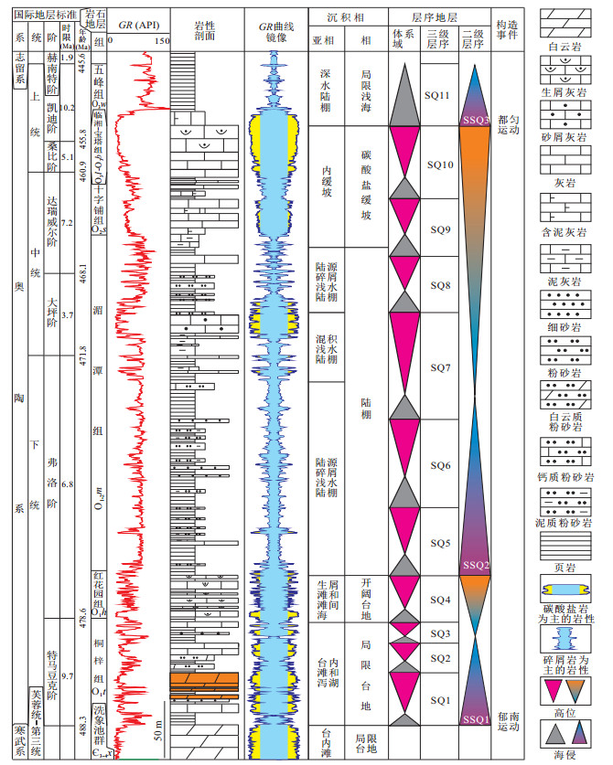
There are different understandings about lithofacies paleogeographic features of Ordovician in Sichuan Basin, and its synsedimentary paleo-uplifts need further research.Using the latest well, seismic data and field data, a study on the Ordovician lithofacies paleogeography on the basis of the sequence stratigraphic division and comparison is carried out.The Ordovician third-order sequence stratigraphic framework in the Upper Yangtze region was established, and the lithofacies palaeogeography of the key stratigraphic sequence was reconstructed.The study reveals that the sedimentary filling texture of Ordovician was controlled by second-order sequence stratigraphy.The strata thickness varies in the lower of each second-order sequence stratigraphy, indicating distinct fluctuant paleogeomorphology.Third-order sequence stratigraphy overlied toward the paleo-uplift region resulting in the loss of strata.The range of paleo-uplift was reduced at the late stage of second-order sequence, and the stratigraphic thickness of the third-order sequence was generally stable as the result of filling.The analysis of lithofacies paleogeography reveals that stable uplifts surrounded the central depressions from three sides, including the north, west, and south during Ordovician, and paleo-uplift in central Sichuan divided central depressions into two parts clearly.It is believed that the paleo-uplift in the central Sichuan and the paleo-uplift on both north and south sides are characterized by intermittent expansion.An uplift area exists during SSQ2 in the east of Sichuan.The central depression has the characteristics of continuous settlement and eastward migration.The study reveals that Early Ordovician Tongzi Formation had inherited the overall paleogeographic background of Loushanguan Group of Cambrian, forming two gypsum rock areas and dolomitization grain shoals distributed around paleo-uplift.In addition, delta depositions sourced from the west of study area maybe existed during Meitan period.
There are different understandings about lithofacies paleogeographic features of Ordovician in Sichuan Basin, and its synsedimentary paleo-uplifts need further research.Using the latest well, seismic data and field data, a study on the Ordovician lithofacies paleogeography on the basis of the sequence stratigraphic division and comparison is carried out.The Ordovician third-order sequence stratigraphic framework in the Upper Yangtze region was established, and the lithofacies palaeogeography of the key stratigraphic sequence was reconstructed.The study reveals that the sedimentary filling texture of Ordovician was controlled by second-order sequence stratigraphy.The strata thickness varies in the lower of each second-order sequence stratigraphy, indicating distinct fluctuant paleogeomorphology.Third-order sequence stratigraphy overlied toward the paleo-uplift region resulting in the loss of strata.The range of paleo-uplift was reduced at the late stage of second-order sequence, and the stratigraphic thickness of the third-order sequence was generally stable as the result of filling.The analysis of lithofacies paleogeography reveals that stable uplifts surrounded the central depressions from three sides, including the north, west, and south during Ordovician, and paleo-uplift in central Sichuan divided central depressions into two parts clearly.It is believed that the paleo-uplift in the central Sichuan and the paleo-uplift on both north and south sides are characterized by intermittent expansion.An uplift area exists during SSQ2 in the east of Sichuan.The central depression has the characteristics of continuous settlement and eastward migration.The study reveals that Early Ordovician Tongzi Formation had inherited the overall paleogeographic background of Loushanguan Group of Cambrian, forming two gypsum rock areas and dolomitization grain shoals distributed around paleo-uplift.In addition, delta depositions sourced from the west of study area maybe existed during Meitan period.


2019, 44(3): 810-821.
doi: 10.3799/dqkx.2018.328
Abstract:
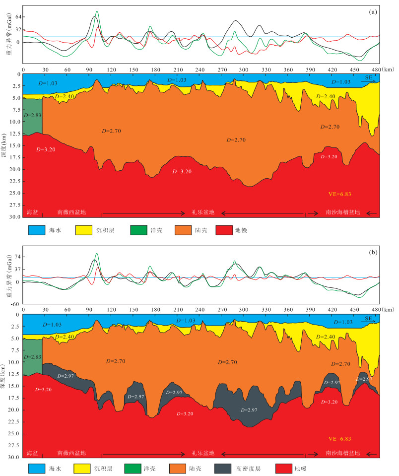
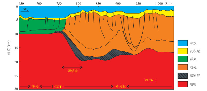
The controversy over the genesis of the high velocity layer limits the understanding of the deep structure, tectonic evolution and complete evolution of the South China Sea.In order to understand the origin of high velocity layer in the lower crust of the southwestern Nansha block, the joint inversion of gravity and seismic data was performed by using Oasis Montaj software in this study.The seismic profile is across the southwestern Nansha Block.The Moho undulation, crustal thickness and the distribution of the high velocity layer are recorded.The regional extension factor and the temperature at the high layer depth are calculated, and the age of volcanic eruption is determined by seismic features.The whole crustal stretching factor of the Nanweixi Basin and the Liyue Basin area is 1.5-4.0, which is impossible to develop serpentine.The whole crustal stretching factor is up to 11.2 in the Nansha trough.The serpentine is formed by the reaction of peridotite and sea water which enters the mantle through the fractures.The temperature near the high velocity layer is lower than the stable temperature of the serpentine.The volcanic eruption was found in the same place in the seismic profile, and the volcano formed after the cessation of the spreading of the South China Sea.The results indicate that the high velocity layer of the southwestern Nansha Block can be divided into two types.The high velocity layer in the Nanweixi and the Liyue basins is formed by volcanic eruption after the cessation of the spreading of the South China Sea; and the other section in the Nansha trough basin is a mixture of serpentinized peridotite and late magma.
The controversy over the genesis of the high velocity layer limits the understanding of the deep structure, tectonic evolution and complete evolution of the South China Sea.In order to understand the origin of high velocity layer in the lower crust of the southwestern Nansha block, the joint inversion of gravity and seismic data was performed by using Oasis Montaj software in this study.The seismic profile is across the southwestern Nansha Block.The Moho undulation, crustal thickness and the distribution of the high velocity layer are recorded.The regional extension factor and the temperature at the high layer depth are calculated, and the age of volcanic eruption is determined by seismic features.The whole crustal stretching factor of the Nanweixi Basin and the Liyue Basin area is 1.5-4.0, which is impossible to develop serpentine.The whole crustal stretching factor is up to 11.2 in the Nansha trough.The serpentine is formed by the reaction of peridotite and sea water which enters the mantle through the fractures.The temperature near the high velocity layer is lower than the stable temperature of the serpentine.The volcanic eruption was found in the same place in the seismic profile, and the volcano formed after the cessation of the spreading of the South China Sea.The results indicate that the high velocity layer of the southwestern Nansha Block can be divided into two types.The high velocity layer in the Nanweixi and the Liyue basins is formed by volcanic eruption after the cessation of the spreading of the South China Sea; and the other section in the Nansha trough basin is a mixture of serpentinized peridotite and late magma.


2019, 44(3): 822-832.
doi: 10.3799/dqkx.2019.001
Abstract:
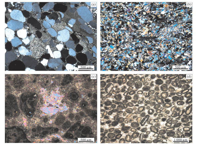
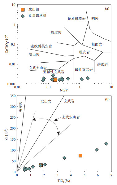
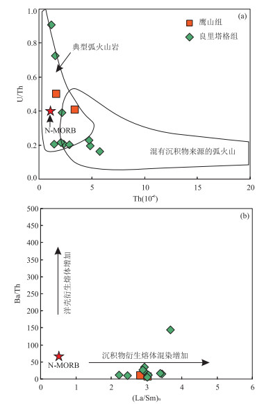
The petrologic and geochemical signatures of volcaniclastic material preserved within carbonate platform deposits from boreholes in the Yanxia area of northern Tarim Basin indicate the presence of an active continental margin volcanic arc during the Middle and Late Ordovician.The volcaniclastics within the Middle Ordovician Yingshan Formation occur as thin layers of basic tuffites in which the vitric grains have undergone partial replacement by carbonate and clay.The volcaniclastics within the Upper Ordovician Lianglitage Formation are primarily basic volcanic clasts within oolitic and grainstone shoal deposits.Geochemical ratios, especially those of Th/Yb-Ta/Yb, U/Th-Th and Ba/Th-(La/Sm), fall within the fields for typical volcanic arcs on continental margins and with a variable admixture of fluids that had interacted with pre-volcanic terrestrial sediments.The degree of admixture is greatest in the volcaniclastics within the Lianglitage Formation, which suggests that the inferred subduction of the South Tianshan Ocean crust below the present northern margin of the Tarim plate had begun by Middle Ordovician and had intensified during the Late Ordovician.
The petrologic and geochemical signatures of volcaniclastic material preserved within carbonate platform deposits from boreholes in the Yanxia area of northern Tarim Basin indicate the presence of an active continental margin volcanic arc during the Middle and Late Ordovician.The volcaniclastics within the Middle Ordovician Yingshan Formation occur as thin layers of basic tuffites in which the vitric grains have undergone partial replacement by carbonate and clay.The volcaniclastics within the Upper Ordovician Lianglitage Formation are primarily basic volcanic clasts within oolitic and grainstone shoal deposits.Geochemical ratios, especially those of Th/Yb-Ta/Yb, U/Th-Th and Ba/Th-(La/Sm), fall within the fields for typical volcanic arcs on continental margins and with a variable admixture of fluids that had interacted with pre-volcanic terrestrial sediments.The degree of admixture is greatest in the volcaniclastics within the Lianglitage Formation, which suggests that the inferred subduction of the South Tianshan Ocean crust below the present northern margin of the Tarim plate had begun by Middle Ordovician and had intensified during the Late Ordovician.


2019, 44(3): 833-847.
doi: 10.3799/dqkx.2019.957
Abstract:
Resources are the foundation of oil and gas industry.With the continuous development of exploration and the obviously changed situation, it is urgent to evaluate the potential of domestic conventional and unconventional oil and gas resources, as well as the favorable directions of the remaining resources, in order to consolidate the foundation of the cognition for oil and gas resources.In this paper, the system of methodology and technology in resource assessment for conventional and unconventional resources is researched and developed based on the achievements in oil and gas exploration, geological recognitions and accumulation of research data, which leads to the systematical initiation of 4th resources assessment.According to the results, there is 1 080.31×10⁸ t of conventional oil with 272.50×10⁸ t of recoverable resources.There is 78×1012 m3 of conventional gas with 48.45×10¹² m3 of recoverable resources.There are also abundant unconventional resources in China.There is 672.08×10⁸ t of unconventional oil in which recoverable resources make up 151.81×10⁸ t.There is 284.95×10¹² m3 for unconventional gas in which recoverable resources account for 89.3×10¹² m3.Among these types of unconventional resources, the geological amount of tight oil is 125.80×10⁸ t, the geological amount of oil sands is 12.55×10⁸ t, the geological amount of oil shale is 533.73×10⁸ t, the geological amount of tight gas is 21.86×10¹² m3, the geological amount of shale gas is 80.21×10¹² m3, the geological amount of coalbed methane is 29.82×10¹² m3, the geological amount of natural gas hydrate is 153.06×10¹² m3.The remaining resources of conventional oil and gas are mainly distributed in 4 domains, which are clastic rocks in domain of lithologyformation, clastic rocks of complex structures, carbonatites of marine facies and belts of foreland thrust.The onshore part of remaining oil is mainly distributed in the former 2 domains.The onshore part of remaining gas is mainly distributed in the latter 2 domains.The offshore resources are mainly in 3 domains which are structures, bio-reefs and lithologic traps of deep water.
Resources are the foundation of oil and gas industry.With the continuous development of exploration and the obviously changed situation, it is urgent to evaluate the potential of domestic conventional and unconventional oil and gas resources, as well as the favorable directions of the remaining resources, in order to consolidate the foundation of the cognition for oil and gas resources.In this paper, the system of methodology and technology in resource assessment for conventional and unconventional resources is researched and developed based on the achievements in oil and gas exploration, geological recognitions and accumulation of research data, which leads to the systematical initiation of 4th resources assessment.According to the results, there is 1 080.31×10⁸ t of conventional oil with 272.50×10⁸ t of recoverable resources.There is 78×1012 m3 of conventional gas with 48.45×10¹² m3 of recoverable resources.There are also abundant unconventional resources in China.There is 672.08×10⁸ t of unconventional oil in which recoverable resources make up 151.81×10⁸ t.There is 284.95×10¹² m3 for unconventional gas in which recoverable resources account for 89.3×10¹² m3.Among these types of unconventional resources, the geological amount of tight oil is 125.80×10⁸ t, the geological amount of oil sands is 12.55×10⁸ t, the geological amount of oil shale is 533.73×10⁸ t, the geological amount of tight gas is 21.86×10¹² m3, the geological amount of shale gas is 80.21×10¹² m3, the geological amount of coalbed methane is 29.82×10¹² m3, the geological amount of natural gas hydrate is 153.06×10¹² m3.The remaining resources of conventional oil and gas are mainly distributed in 4 domains, which are clastic rocks in domain of lithologyformation, clastic rocks of complex structures, carbonatites of marine facies and belts of foreland thrust.The onshore part of remaining oil is mainly distributed in the former 2 domains.The onshore part of remaining gas is mainly distributed in the latter 2 domains.The offshore resources are mainly in 3 domains which are structures, bio-reefs and lithologic traps of deep water.


2019, 44(3): 909-918.
doi: 10.3799/dqkx.2018.368
Abstract:
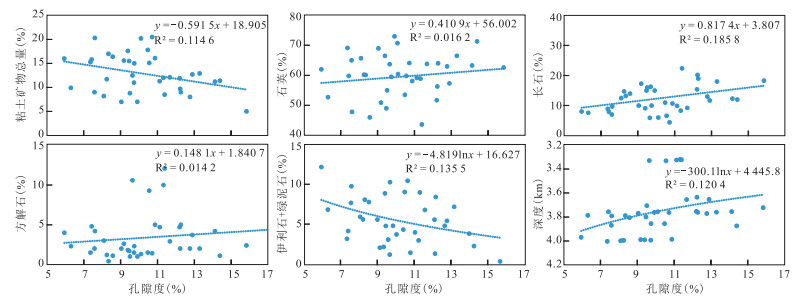
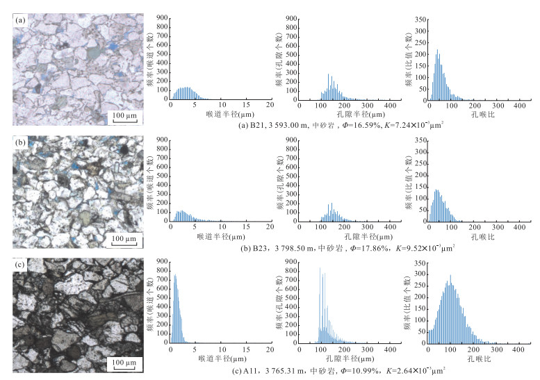
The research on the impacts of authigenic clay minerals on pore throat structure and hydrocarbon migration and accumulation is very weak.In this study, impacts of authigenic clay on pore connectivity, pore-throat size and its distribution were investigated for the resulting impacts on hydrocarbon accumulation and percolation in order to find out the genetic mechanism of tight sandstones in Oligocene Zhuhai Formation of Wenchang A Sag, Pearl River Mouth Basin.Thin slice identification, whole rock X-ray diffraction analysis, scanning electron microscopy and rate-controlled mercury injection were employed to characterize authigenic clay and its physical property.Source-reservoir assemblages were studied based on burial history and hydrocarbon-generating history of underlying source rocks.Two types were distinguished as "pore combined with throat" and "fine diameter throat-controlling".The former contains more interparticle pores and thick throat, while the latter contains mainly narrow throat.Mechanical compaction led to primary porosity lost and authigenic clay-related pores gradually played a significant role in controlling pore structure of tight sandstone reservoirs.There is very little difference in porosity and wide distribution in permeability between the two pore structure types.The unconformity contact between reservoirs and source rocks forms a favorable source-storage combination for lateral continuous distribution, and the source rocks have been generating hydrocarbon constantly.Mechanical compaction and authigenic clay are considered to be control factors affecting reservoir property and hydrocarbon enrichment for the following reasons:the pore structure and permeability are chiefly controlled by fine diameter of pore and throat as well as complex relation between pore and throat, the underlying source rocks have been providing constant driving force and hydrocarbon supply.Zhuhai Formation serves a representative example for deep buried tight sandstone reservoir.
The research on the impacts of authigenic clay minerals on pore throat structure and hydrocarbon migration and accumulation is very weak.In this study, impacts of authigenic clay on pore connectivity, pore-throat size and its distribution were investigated for the resulting impacts on hydrocarbon accumulation and percolation in order to find out the genetic mechanism of tight sandstones in Oligocene Zhuhai Formation of Wenchang A Sag, Pearl River Mouth Basin.Thin slice identification, whole rock X-ray diffraction analysis, scanning electron microscopy and rate-controlled mercury injection were employed to characterize authigenic clay and its physical property.Source-reservoir assemblages were studied based on burial history and hydrocarbon-generating history of underlying source rocks.Two types were distinguished as "pore combined with throat" and "fine diameter throat-controlling".The former contains more interparticle pores and thick throat, while the latter contains mainly narrow throat.Mechanical compaction led to primary porosity lost and authigenic clay-related pores gradually played a significant role in controlling pore structure of tight sandstone reservoirs.There is very little difference in porosity and wide distribution in permeability between the two pore structure types.The unconformity contact between reservoirs and source rocks forms a favorable source-storage combination for lateral continuous distribution, and the source rocks have been generating hydrocarbon constantly.Mechanical compaction and authigenic clay are considered to be control factors affecting reservoir property and hydrocarbon enrichment for the following reasons:the pore structure and permeability are chiefly controlled by fine diameter of pore and throat as well as complex relation between pore and throat, the underlying source rocks have been providing constant driving force and hydrocarbon supply.Zhuhai Formation serves a representative example for deep buried tight sandstone reservoir.


2019, 44(3): 919-928.
doi: 10.3799/dqkx.2018.116
Abstract:
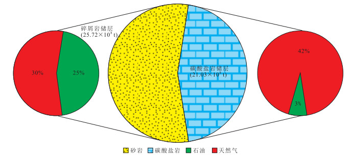
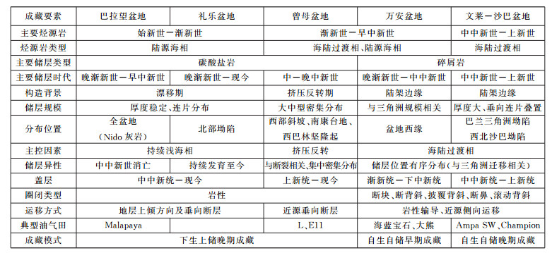
Few of researchers take the central-southern South China Sea (SCS) as a whole to study the oil and gas accumulation model.The hydrocarbon distribution features and accumulation models of both clastic reservoirs and carbonate reservoirs in central-southern SCS have been studied, based on both the previous research but also comprehensive analyses of tectonic evolution, source rock and key oil and gas field analysis.The results indicate that clastic reservoirs are mainly distributed in western Wan'an Basin, southern Zengmu Basin and Brunei-Sabah Basin.Carbonate reservoirs are mainly distributed in eastern Wan'an Basin, central-northern Zengmu Basin, Liyue Basin and Palawan Basin.There are 54 giant-supergiant oil and gas fields in central-southern SCS, among which 32 are clastic reservoirs while others are carbonate reservoirs.Reserves of these 54 fields are 4.67 billion tons, accounting for 81% of the total reserves of the whole area.Based on the characteristic analysis of source rocks, reservoirs and hydrocarbon accumulation of the key oil and gas fields, there are 3 kinds of accumulation patterns, and their features are as follows:source and reservoir in same layer, oil-rich clastic reservoirs, early-stage accumulation; lower-source and upper-reservoirs; gas-rich carbonate reservoirs, late-stage accumulation; source and reservoirs in same layer, oil and gas-rich clastic reservoirs, and late-stage accumulation.
Few of researchers take the central-southern South China Sea (SCS) as a whole to study the oil and gas accumulation model.The hydrocarbon distribution features and accumulation models of both clastic reservoirs and carbonate reservoirs in central-southern SCS have been studied, based on both the previous research but also comprehensive analyses of tectonic evolution, source rock and key oil and gas field analysis.The results indicate that clastic reservoirs are mainly distributed in western Wan'an Basin, southern Zengmu Basin and Brunei-Sabah Basin.Carbonate reservoirs are mainly distributed in eastern Wan'an Basin, central-northern Zengmu Basin, Liyue Basin and Palawan Basin.There are 54 giant-supergiant oil and gas fields in central-southern SCS, among which 32 are clastic reservoirs while others are carbonate reservoirs.Reserves of these 54 fields are 4.67 billion tons, accounting for 81% of the total reserves of the whole area.Based on the characteristic analysis of source rocks, reservoirs and hydrocarbon accumulation of the key oil and gas fields, there are 3 kinds of accumulation patterns, and their features are as follows:source and reservoir in same layer, oil-rich clastic reservoirs, early-stage accumulation; lower-source and upper-reservoirs; gas-rich carbonate reservoirs, late-stage accumulation; source and reservoirs in same layer, oil and gas-rich clastic reservoirs, and late-stage accumulation.


2019, 44(3): 848-858.
doi: 10.3799/dqkx.2018.377
Abstract:
Researches on the hydrocarbon potential of the source rock in the Paleogene Funing Formation, and origin of the Paleogene crude oil in the southern depression of the South Yellow Sea Basin (SYSB) are relatively weak.Based on the systematically organic geochemical analyses (TOC, Rock-Eval, GC-MS of saturates and aromatics, stable carbon isotope) of the Paleogene core, cuttings, oil sand and crude oil samples, combined with vitrinite reflectance determination, the geochemical characteristics of source rocks and crude oil are revealed, and oil-source correlation is obtained.The results indicate that the Paleogene source rocks in the southern depression mainly deposited in the fourth (E1f4) and second memebers (E1f2) of Funing Formation, with moderate-good organic matter (OM) abundance, type Ⅱ2-Ⅲ kerogen and within low mature-mature stage.Mixed OM sources, dominated by terrestrial OM are observed in E1f4 and E1f2 source rocks, biomarker ratios indicate that E1f4 source rocks were deposited in dysoxic, relatively high salinity condition.Whereas during E1f2 source rocks deposition, anoxic and relatively low salinity condition is prevailed.The Paleogene crude oil contains relatively high saturates content, with small UCM peak, and has entered into the mature stage.Oil-source correlation results indicate that the Dainan crude oil (oil sand extraction) is related to the E1f4 source rocks, whereas E1f3 crude oil may be derived from E1f2 source rocks.
Researches on the hydrocarbon potential of the source rock in the Paleogene Funing Formation, and origin of the Paleogene crude oil in the southern depression of the South Yellow Sea Basin (SYSB) are relatively weak.Based on the systematically organic geochemical analyses (TOC, Rock-Eval, GC-MS of saturates and aromatics, stable carbon isotope) of the Paleogene core, cuttings, oil sand and crude oil samples, combined with vitrinite reflectance determination, the geochemical characteristics of source rocks and crude oil are revealed, and oil-source correlation is obtained.The results indicate that the Paleogene source rocks in the southern depression mainly deposited in the fourth (E1f4) and second memebers (E1f2) of Funing Formation, with moderate-good organic matter (OM) abundance, type Ⅱ2-Ⅲ kerogen and within low mature-mature stage.Mixed OM sources, dominated by terrestrial OM are observed in E1f4 and E1f2 source rocks, biomarker ratios indicate that E1f4 source rocks were deposited in dysoxic, relatively high salinity condition.Whereas during E1f2 source rocks deposition, anoxic and relatively low salinity condition is prevailed.The Paleogene crude oil contains relatively high saturates content, with small UCM peak, and has entered into the mature stage.Oil-source correlation results indicate that the Dainan crude oil (oil sand extraction) is related to the E1f4 source rocks, whereas E1f3 crude oil may be derived from E1f2 source rocks.


2019, 44(3): 859-871.
doi: 10.3799/dqkx.2018.236
Abstract:
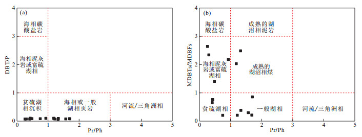
The 5th member of the Upper Triassic Xujiahe Formation (T3x5) is one of the important targets for terrigenous natural gas exploration in the Xinchang gas field in the West Sichuan Depression.The molecular geochemical characteristics have been analyzed in order to further determine the sedimentary environment of the T3x source rocks.The studies indicate that the Pr/Ph ratio of soluble extract from the T3x5 mudstone in the Xinchang gas field ranges from 0.26 to 1.70, and the relative contents of C27 and C29 in C27-C29 regular steranes are 31.2% and 44.6%, respectively.The gammacerane/C30 hopane ratio ranges from 0.11 to 0.34, and the MPI1, F1 and 4-/1-MDBT values of the T3x5 mudstone are all positively correlated with thermal maturity.The organic source of the T3x5 mudstone is dominated by terrigenous higher plant, and lower hydrobiont and algae have also made a certain contribution.The T3x5 mudstone was mainly deposited in the lacustrine environment, with part of the samples in the anoxic saline environment.Thermal maturity can significantly affect several indexes of aromatic compounds in coal-measure source rocks, and the three fluorene series of samples with Ro>1.25% and MDBTs/MDBFs ratios of samples with Ro>1.2% can not be directly used to determine the sedimentary environment.
The 5th member of the Upper Triassic Xujiahe Formation (T3x5) is one of the important targets for terrigenous natural gas exploration in the Xinchang gas field in the West Sichuan Depression.The molecular geochemical characteristics have been analyzed in order to further determine the sedimentary environment of the T3x source rocks.The studies indicate that the Pr/Ph ratio of soluble extract from the T3x5 mudstone in the Xinchang gas field ranges from 0.26 to 1.70, and the relative contents of C27 and C29 in C27-C29 regular steranes are 31.2% and 44.6%, respectively.The gammacerane/C30 hopane ratio ranges from 0.11 to 0.34, and the MPI1, F1 and 4-/1-MDBT values of the T3x5 mudstone are all positively correlated with thermal maturity.The organic source of the T3x5 mudstone is dominated by terrigenous higher plant, and lower hydrobiont and algae have also made a certain contribution.The T3x5 mudstone was mainly deposited in the lacustrine environment, with part of the samples in the anoxic saline environment.Thermal maturity can significantly affect several indexes of aromatic compounds in coal-measure source rocks, and the three fluorene series of samples with Ro>1.25% and MDBTs/MDBFs ratios of samples with Ro>1.2% can not be directly used to determine the sedimentary environment.


2019, 44(3): 872-879.
doi: 10.3799/dqkx.2018.344
Abstract:
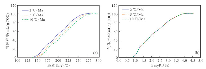
The kinetics data of hydrocarbon generation in South Yellow Sea Basin is very important for its hydrocarbon potential evaluation.Pyrolysis experiments of Qixia Formation and Qinglong Formation carbonate samples in South Yellow Sea basin were carried out by using gold tube-autoclave instruments in finite space and then the kinetics data of hydrocarbon generation was analyzed.The results show that gas generation rate of Qixia carbonate is 102 mL/g TOC, and that of Qinglong Formation is 78 mL/g TOC.The mean value of activation energy of Qixia carbonate is 52 kcal/mol, and that of Qinglong carbonate is 60 kcal/mol.The low value of activation energy of Qixia carbonate is possibly caused by the residual hydrocarbon in the sample.The relationship between the maturity parameter Ro and the gas generation rate is not affected by the rate of geo-heating rate, so the parameters can be used to simulate the carbonate hydrocarbon generation in South Yellow Sea Basin.
The kinetics data of hydrocarbon generation in South Yellow Sea Basin is very important for its hydrocarbon potential evaluation.Pyrolysis experiments of Qixia Formation and Qinglong Formation carbonate samples in South Yellow Sea basin were carried out by using gold tube-autoclave instruments in finite space and then the kinetics data of hydrocarbon generation was analyzed.The results show that gas generation rate of Qixia carbonate is 102 mL/g TOC, and that of Qinglong Formation is 78 mL/g TOC.The mean value of activation energy of Qixia carbonate is 52 kcal/mol, and that of Qinglong carbonate is 60 kcal/mol.The low value of activation energy of Qixia carbonate is possibly caused by the residual hydrocarbon in the sample.The relationship between the maturity parameter Ro and the gas generation rate is not affected by the rate of geo-heating rate, so the parameters can be used to simulate the carbonate hydrocarbon generation in South Yellow Sea Basin.


2019, 44(3): 880-897.
doi: 10.3799/dqkx.2019.025
Abstract:
In order to promote the exploration process of lithologic hydrocarbon reservoir in Pingbei slope of Xihu Sag and to clarify the development mode and distribution law of lithologic sand body, a comprehensive study is presented in this paper, based on the analyses of the latest drilling, thin sections, heavy minerals and high-resolution 3D seismic data of Pingbei slope in the Xihu Sag, East China Sea.The analyses of heavy mineral composition and debris show the components, orientation, and supply strength of the provenance.In addition, the analyses of logging and cores, the seismic facies and multi-attribute reveal the tidal transformation mechanism in the distribution and evolution of sediments.On the basis of quantitative and semi-quantitative analysis of various elements of Source-to-Sink (S2S) systems correlation combined with the paleogeomorphology and faults, the coupling differences of S2S systems under the control of provenance supply and tidal action are clarified.The results show that low provenance supply-single stage fault-tidal control, intermediate provenance supply-paleo-uplift and reverse step faults-river-tidal control, and high provenance supply-consequent step faults-river-tidal control coupling models are established.On this basis, the sedimentary distribution cause and law of each S2S system are systematically discussed.The establishment of different coupling models of S2S systems can provide the key directions of petroleum exploration.In addition, this study also provides reference methods and ideas for the research of S2S systems under different geological backgrounds.
In order to promote the exploration process of lithologic hydrocarbon reservoir in Pingbei slope of Xihu Sag and to clarify the development mode and distribution law of lithologic sand body, a comprehensive study is presented in this paper, based on the analyses of the latest drilling, thin sections, heavy minerals and high-resolution 3D seismic data of Pingbei slope in the Xihu Sag, East China Sea.The analyses of heavy mineral composition and debris show the components, orientation, and supply strength of the provenance.In addition, the analyses of logging and cores, the seismic facies and multi-attribute reveal the tidal transformation mechanism in the distribution and evolution of sediments.On the basis of quantitative and semi-quantitative analysis of various elements of Source-to-Sink (S2S) systems correlation combined with the paleogeomorphology and faults, the coupling differences of S2S systems under the control of provenance supply and tidal action are clarified.The results show that low provenance supply-single stage fault-tidal control, intermediate provenance supply-paleo-uplift and reverse step faults-river-tidal control, and high provenance supply-consequent step faults-river-tidal control coupling models are established.On this basis, the sedimentary distribution cause and law of each S2S system are systematically discussed.The establishment of different coupling models of S2S systems can provide the key directions of petroleum exploration.In addition, this study also provides reference methods and ideas for the research of S2S systems under different geological backgrounds.


2019, 44(3): 898-908.
doi: 10.3799/dqkx.2018.940
Abstract:
Source rock in Pinghu Formation of Eocene is the main source rock series in Xihu hydrocarbon generating sag of the East China Sea shelf basin, and it is also a typical source rock of marine-continental transitional face in the faulted basins of East China.Using drilling, seismic data combined with organic geochemistry and paleontology data of hydrocarbon source rock, the development controlling factors for the Pinghu Formation are discussed and the forming model is established by analyses of characteristics of the hydrocarbon source rock and tectonic-sedimentary-palaeoclimate development background in this study.It is found that source rocks in Pinghu Formation of Xihu Sag are characterized by wide distribution, large thickness and multiple series of thin coal seam with carbonaceous mudstone, relatively high quality of source rocks.The development background of Pinghu Formation is a semi-enclosed bay environment with warm-humid subtropical climate condition, and predominantly terrestrial organic matter contribution.The development of hydrocarbon source rocks in Pinghu Formation is mainly affected by sedimentation-subsidence rate, source material and preservation condition of organic matter, forming model could be concluded with "rapid subsidence, warm-humid climate, terrestrial organic matter, fresh-brackish water, and relatively strong oxidation condition".
Source rock in Pinghu Formation of Eocene is the main source rock series in Xihu hydrocarbon generating sag of the East China Sea shelf basin, and it is also a typical source rock of marine-continental transitional face in the faulted basins of East China.Using drilling, seismic data combined with organic geochemistry and paleontology data of hydrocarbon source rock, the development controlling factors for the Pinghu Formation are discussed and the forming model is established by analyses of characteristics of the hydrocarbon source rock and tectonic-sedimentary-palaeoclimate development background in this study.It is found that source rocks in Pinghu Formation of Xihu Sag are characterized by wide distribution, large thickness and multiple series of thin coal seam with carbonaceous mudstone, relatively high quality of source rocks.The development background of Pinghu Formation is a semi-enclosed bay environment with warm-humid subtropical climate condition, and predominantly terrestrial organic matter contribution.The development of hydrocarbon source rocks in Pinghu Formation is mainly affected by sedimentation-subsidence rate, source material and preservation condition of organic matter, forming model could be concluded with "rapid subsidence, warm-humid climate, terrestrial organic matter, fresh-brackish water, and relatively strong oxidation condition".


2019, 44(3): 929-938.
doi: 10.3799/dqkx.2018.354
Abstract:
Assessment of shale oil potential is an important issue for predicting the sweet spots of shale oil exploration.Here, we suggest a new free hydrocarbon index to assess the oil content considering the characteristics of heterogeneity, and we present a case study of the Paleogene Hetaoyuan Formation in the Biyang Depression by this method to analyze the key wells of shale oil in the deep sag, Biyang Depression.First, the section characteristics of free hydrocarbon difference for the No.5 shale layer in Well Biye1 and Well Cheng2 are depicted.The results show that the oil potential for the No.5 shale layer is good for the bottom of Well Biye1 and the top of Well Cheng2.Then, the above-mentioned process is appled to the whole deep sag to predict the horizontal distribution of shale oil.It is found that the area of good shale oil potential is located in the area of Well Cheng2, while the area of Biye1 is not the best shale oil area though the industrial shale oil has been found there.Combined with the formation pressure coefficient and the content of brittle mineral, we overlap the thickness of non-mudstone interlayer, the development area of micro-cracks and the distribution of micro-structures, and three different grades of small sweet spots have been proposed based on the previous one big sweet spots.This prediction has been partly proved by the recent exploration.
Assessment of shale oil potential is an important issue for predicting the sweet spots of shale oil exploration.Here, we suggest a new free hydrocarbon index to assess the oil content considering the characteristics of heterogeneity, and we present a case study of the Paleogene Hetaoyuan Formation in the Biyang Depression by this method to analyze the key wells of shale oil in the deep sag, Biyang Depression.First, the section characteristics of free hydrocarbon difference for the No.5 shale layer in Well Biye1 and Well Cheng2 are depicted.The results show that the oil potential for the No.5 shale layer is good for the bottom of Well Biye1 and the top of Well Cheng2.Then, the above-mentioned process is appled to the whole deep sag to predict the horizontal distribution of shale oil.It is found that the area of good shale oil potential is located in the area of Well Cheng2, while the area of Biye1 is not the best shale oil area though the industrial shale oil has been found there.Combined with the formation pressure coefficient and the content of brittle mineral, we overlap the thickness of non-mudstone interlayer, the development area of micro-cracks and the distribution of micro-structures, and three different grades of small sweet spots have been proposed based on the previous one big sweet spots.This prediction has been partly proved by the recent exploration.


2019, 44(3): 939-952.
doi: 10.3799/dqkx.2018.291
Abstract:
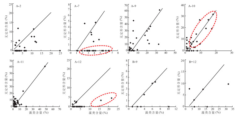
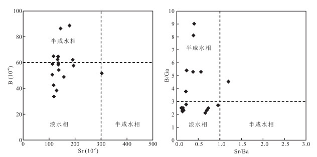
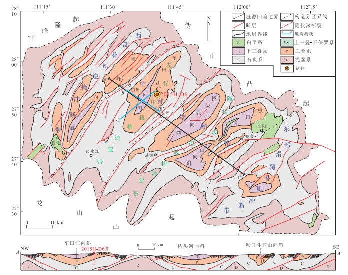
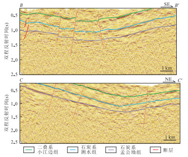
There are few studies on the reservoirs and hydrocarbon accumulation characteristics of the marine-continental transitional shale.Lower Carboniferous Ceshui Formation transitional shale is one of the most important shale gas exploration beds in Lianyuan Sag of Xiangzhong Depression.In this paper, the accumulation characteristics of marine-terrigenous facies shale of the study area are discussed on the basis of 2D seismic data, drilling core and logging data.Firstly, the structure of Well 2015H-D6, and the lithology of Ceshui Formation are described.Then, testing and analysis of the geochemical, physical properties and gas content of shale reservoir are carried out.Finally, the burial and thermal history of the single well is simulated.Reuslts illustrate that Ceshui shale in Lianyuan Sag deposited in coastal lagoon or swamp environment with a deposition thickness of 71.8 m and a buried depth of more than 2 500 m.The shale with type Ⅱ kerogen remains in over-mature stage, with the average organic carbon content of 1.68%, and the maturity ranging from 2.30%~3.32%(average value of 2.96%).The brittle mineral content exceeds 60%, and clay mineral content is less than 30%.The shale is characterized by low porosity and permeability, with microspore dominated reservoir porosity, which shows better shale gas reservoir conditions.It is revealed that the Ceshui shale has a good content of shale gas by well logging interpretation, isothermal adsorption and in-situ gas quantity analysis.Combining with single-well burial, thermal history simulation, and the evolution of shale gas reservoir, it is concluded that the stable tectonic and sustaining subsidence are the key factors of shale gas accumulation formed in Lianyuan Sag.
There are few studies on the reservoirs and hydrocarbon accumulation characteristics of the marine-continental transitional shale.Lower Carboniferous Ceshui Formation transitional shale is one of the most important shale gas exploration beds in Lianyuan Sag of Xiangzhong Depression.In this paper, the accumulation characteristics of marine-terrigenous facies shale of the study area are discussed on the basis of 2D seismic data, drilling core and logging data.Firstly, the structure of Well 2015H-D6, and the lithology of Ceshui Formation are described.Then, testing and analysis of the geochemical, physical properties and gas content of shale reservoir are carried out.Finally, the burial and thermal history of the single well is simulated.Reuslts illustrate that Ceshui shale in Lianyuan Sag deposited in coastal lagoon or swamp environment with a deposition thickness of 71.8 m and a buried depth of more than 2 500 m.The shale with type Ⅱ kerogen remains in over-mature stage, with the average organic carbon content of 1.68%, and the maturity ranging from 2.30%~3.32%(average value of 2.96%).The brittle mineral content exceeds 60%, and clay mineral content is less than 30%.The shale is characterized by low porosity and permeability, with microspore dominated reservoir porosity, which shows better shale gas reservoir conditions.It is revealed that the Ceshui shale has a good content of shale gas by well logging interpretation, isothermal adsorption and in-situ gas quantity analysis.Combining with single-well burial, thermal history simulation, and the evolution of shale gas reservoir, it is concluded that the stable tectonic and sustaining subsidence are the key factors of shale gas accumulation formed in Lianyuan Sag.


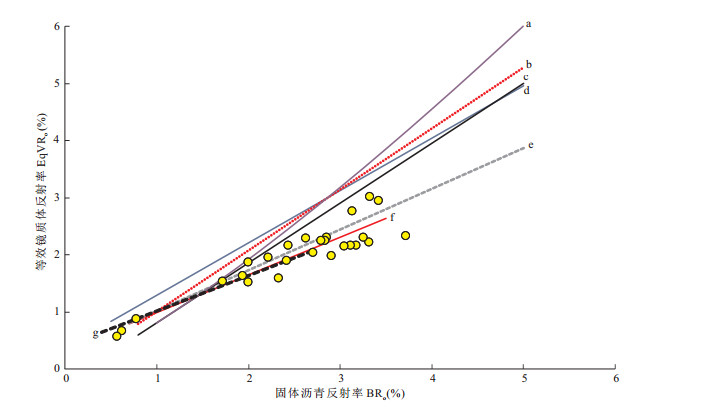
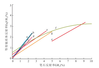
2019, 44(3): 953-971.
doi: 10.3799/dqkx.2018.125
Abstract:
The marine shale of Upper Ordovician Wufeng Formation (O3w)-Lower Silurian Longmaxi Formation (S1l) is the main source rock and the target of shale gas exploration in Sichuan Basin.Organic matter maturity is not only the key to evaluate hydrocarbon generation, but also a vital indicator of shale quality evaluation.The maturity of organic matter in Lower Paleozoic shale has always been a difficult and hot issue in organic petrology.However, the previous studies were focused on the conversion of solid bitumen reflectance to equivalent vitrinite reflectance on account of the lack of vitrinite in Lower Paleozoic stratum.And the limitation and uncertainty of bitumen give rise to a lack of uniform understanding and systematic research of Wufeng-Longmaxi shale on thermal maturity.The core and outcrop samples of Wufeng-Longmaxi shale were collected in Sichuan Basin and its periphery areas for optical analysis of organic matter.The macerals and optical characteristics of various organic matter in Wufeng-Longmaxi shale were analyzed.The main macerals organic components are composed of the graptolite fragments and solid bitumen.Two types of solid bitumen have been distinguished in shales, based on optical properties and microstructure characteristics in reflected light:(1) pyrobitumen—a highly reflecting granular and sharp angular bitumen accumulates in intergranular pore spaces and microfractures; (2) matrix solid bitumen—an irregular granular surface and finely organic matter particle widely disseminated in the clay mineral matrix with low reflectance.The random reflectance of pyrobitumen is slightly lower than that of graptolite in the same sample.The increase of graptolite reflectance is faster than that of solid bitumen with the increase of maturity, and anisotropy increases significantly.Both pyrobitumen and graptolite can be used for maturity analysis in Lower Paleozoic shale.Compared to the reflectance of solid bitumen, the random reflectance of graptolite is more suitable as maturity index due to reflectance value show a narrower range.However, its relationship with vitrinite reflectance at overmature stage still needs further study.
The marine shale of Upper Ordovician Wufeng Formation (O3w)-Lower Silurian Longmaxi Formation (S1l) is the main source rock and the target of shale gas exploration in Sichuan Basin.Organic matter maturity is not only the key to evaluate hydrocarbon generation, but also a vital indicator of shale quality evaluation.The maturity of organic matter in Lower Paleozoic shale has always been a difficult and hot issue in organic petrology.However, the previous studies were focused on the conversion of solid bitumen reflectance to equivalent vitrinite reflectance on account of the lack of vitrinite in Lower Paleozoic stratum.And the limitation and uncertainty of bitumen give rise to a lack of uniform understanding and systematic research of Wufeng-Longmaxi shale on thermal maturity.The core and outcrop samples of Wufeng-Longmaxi shale were collected in Sichuan Basin and its periphery areas for optical analysis of organic matter.The macerals and optical characteristics of various organic matter in Wufeng-Longmaxi shale were analyzed.The main macerals organic components are composed of the graptolite fragments and solid bitumen.Two types of solid bitumen have been distinguished in shales, based on optical properties and microstructure characteristics in reflected light:(1) pyrobitumen—a highly reflecting granular and sharp angular bitumen accumulates in intergranular pore spaces and microfractures; (2) matrix solid bitumen—an irregular granular surface and finely organic matter particle widely disseminated in the clay mineral matrix with low reflectance.The random reflectance of pyrobitumen is slightly lower than that of graptolite in the same sample.The increase of graptolite reflectance is faster than that of solid bitumen with the increase of maturity, and anisotropy increases significantly.Both pyrobitumen and graptolite can be used for maturity analysis in Lower Paleozoic shale.Compared to the reflectance of solid bitumen, the random reflectance of graptolite is more suitable as maturity index due to reflectance value show a narrower range.However, its relationship with vitrinite reflectance at overmature stage still needs further study.


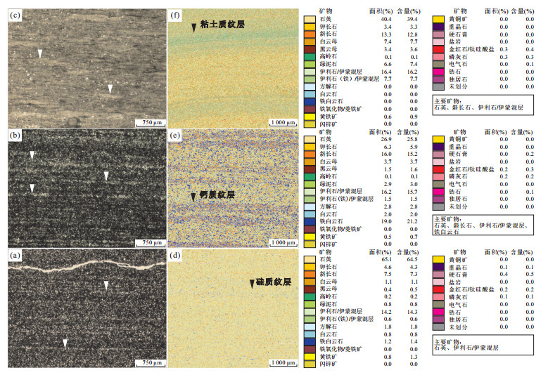
2019, 44(3): 972-982.
doi: 10.3799/dqkx.2019.018
Abstract:
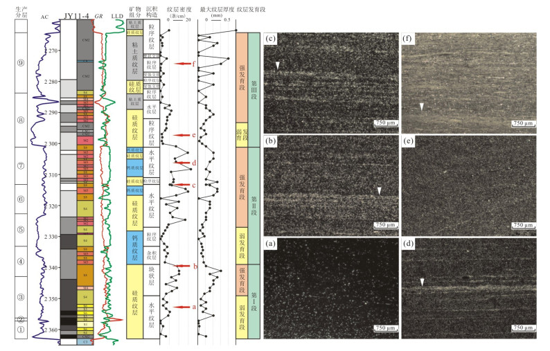
There is no in-depth study on the impact of marine organic-rich shale lamination on reservoir quality.In this paper, according to lamination mineralogical composition, the shale lamination can be divided into sillceous lamina, calcium lamina and clay lamina through thin section, NMR porosity and QEMSCAN.Besides, horizontal lamina, hybrid lamina, graded lamina, cut-fill cross lamina and wedge-shaped cross lamina are found in Wufeng Formation-Longmaxi Formation marine shale.Combined with the laminae density and maximum thickness of laminae, the interval of interest is divided into three lamination development phases, which are subdivided into weak development stage and strong development stage.Composited with shale lamination characteristics and reservoir characteristics, total organic matter content and organic pores were reduced in shale laminated strong development stage, with enhanced development of inorganic pores.The pore type and pore size distribution is influenced by the laminated development.
There is no in-depth study on the impact of marine organic-rich shale lamination on reservoir quality.In this paper, according to lamination mineralogical composition, the shale lamination can be divided into sillceous lamina, calcium lamina and clay lamina through thin section, NMR porosity and QEMSCAN.Besides, horizontal lamina, hybrid lamina, graded lamina, cut-fill cross lamina and wedge-shaped cross lamina are found in Wufeng Formation-Longmaxi Formation marine shale.Combined with the laminae density and maximum thickness of laminae, the interval of interest is divided into three lamination development phases, which are subdivided into weak development stage and strong development stage.Composited with shale lamination characteristics and reservoir characteristics, total organic matter content and organic pores were reduced in shale laminated strong development stage, with enhanced development of inorganic pores.The pore type and pore size distribution is influenced by the laminated development.


2019, 44(3): 983-992.
doi: 10.3799/dqkx.2018.353
Abstract:
The microscopic pore structure of organic-rich shale is an important factor affecting the enrichment of shale gas, but the characteristics of pore structure change during thermal evolution are not clear, which is difficult for the current research.Taking the low-mature oil shale samples of the Middle Permian Lucaogou Formation in the Santanghu Basin, Xinjiang as an example, a high-temperature and high-pressure semi-closed pyrolysis experiment was carried out, and the thermal simulation samples at various temperature stages were extracted, using low-temperature adsorption technique to characterize the pore structure of the un-extracted and extracted sample and to reveal the pore evolution characteristics of the low mature to over mature shale samples.The results show that in the low-mature to mature stage, the content of mesopores decreases with the increase of thermal simulation temperature, and the micropore content decreases first and then rises.High pressure and residual oil/bitumen have certain inhibitory effect for all pores.While at the high maturity stage, the pore content increases significantly, and the micropore and mesopore are generated in the residual bitumen.It indicates that temperature and pressure conditions have important influence on pore structure in thermal simulation experiments.The thermal evolution of organic matter and its evolution products are closely related to the evolution trend of shale pores.
The microscopic pore structure of organic-rich shale is an important factor affecting the enrichment of shale gas, but the characteristics of pore structure change during thermal evolution are not clear, which is difficult for the current research.Taking the low-mature oil shale samples of the Middle Permian Lucaogou Formation in the Santanghu Basin, Xinjiang as an example, a high-temperature and high-pressure semi-closed pyrolysis experiment was carried out, and the thermal simulation samples at various temperature stages were extracted, using low-temperature adsorption technique to characterize the pore structure of the un-extracted and extracted sample and to reveal the pore evolution characteristics of the low mature to over mature shale samples.The results show that in the low-mature to mature stage, the content of mesopores decreases with the increase of thermal simulation temperature, and the micropore content decreases first and then rises.High pressure and residual oil/bitumen have certain inhibitory effect for all pores.While at the high maturity stage, the pore content increases significantly, and the micropore and mesopore are generated in the residual bitumen.It indicates that temperature and pressure conditions have important influence on pore structure in thermal simulation experiments.The thermal evolution of organic matter and its evolution products are closely related to the evolution trend of shale pores.
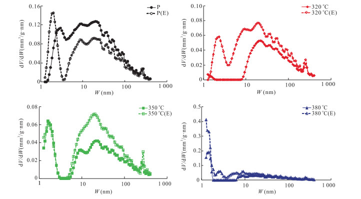


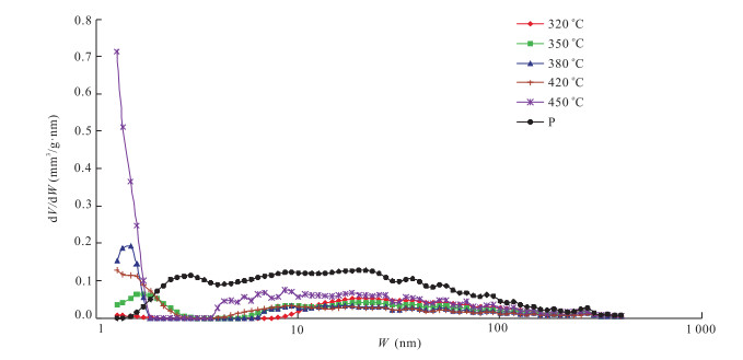
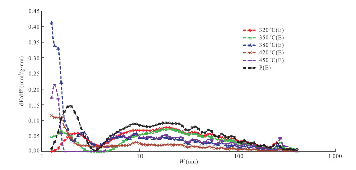


2019, 44(3): 993-1000.
doi: 10.3799/dqkx.2018.943
Abstract:
Most of the marine shale strata in South China have undergone poly-cycle complex structural superimposition and reformation after hydrocarbon generation, forming many types of structural styles, and the enrichment degree of shale gas in different styles is obviously different.Based on the analysis, testing and the detailed anatomy of the logging and seismic data in dozens of shale gas exploration wells in South China, and more than 300 development wells in the Fuling shale gas fields, a set of direct and indirect indicators for shale gas bearing evaluation in South China are established combining with actual drilling results.Based on the typical background of extrusion structure in South China, focusing on the structural tightness (broad, narrow and steep, fractured) and structural forms (positive, negative and oblique), 24 structural models representing the differential enrichment of shale gas are proposed.Under the premise of the same macroscopic structural background, the broad structural model is the most favorable mode for shale gas enrichment, followed by the narrow-steep type, and the fractured type is the worst.
Most of the marine shale strata in South China have undergone poly-cycle complex structural superimposition and reformation after hydrocarbon generation, forming many types of structural styles, and the enrichment degree of shale gas in different styles is obviously different.Based on the analysis, testing and the detailed anatomy of the logging and seismic data in dozens of shale gas exploration wells in South China, and more than 300 development wells in the Fuling shale gas fields, a set of direct and indirect indicators for shale gas bearing evaluation in South China are established combining with actual drilling results.Based on the typical background of extrusion structure in South China, focusing on the structural tightness (broad, narrow and steep, fractured) and structural forms (positive, negative and oblique), 24 structural models representing the differential enrichment of shale gas are proposed.Under the premise of the same macroscopic structural background, the broad structural model is the most favorable mode for shale gas enrichment, followed by the narrow-steep type, and the fractured type is the worst.
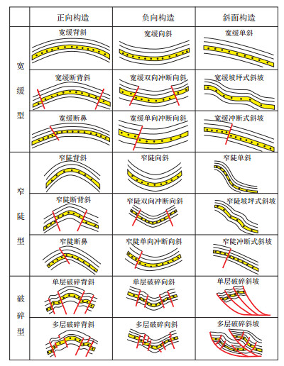


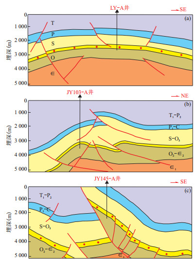
2019, 44(3): 1001-1011.
doi: 10.3799/dqkx.2018.388
Abstract:
In order to solve the problem of obvious contradiction between measured gas content and test yield in single well during shale gas development, a systematic comparative study of log interpretation gas content and measured gas content is carried out.It is considered that it is feasible to use log interpretation gas content to replace measured gas content in Jiaoshiba area.On the basis of detailed comparison of the effects of organic matter abundance, organic matter maturity, pore structure, formation temperature and pressure on shale gas content, it is clear that pore structure is the main factor controlling the occurrence characteristics of shale gas.The difference of pore size and porosity caused by the difference of vertical organic matter abundance is the main reason for the change of occurrence state of upper and lower gas reservoirs in Jiaoshiba area, Fuling.For the evaluation of marine shale development constituencies in southern China, more attention should be paid to the study of the influence of shale pore structure on the occurrence state in the optimization of favorable areas for future development.
In order to solve the problem of obvious contradiction between measured gas content and test yield in single well during shale gas development, a systematic comparative study of log interpretation gas content and measured gas content is carried out.It is considered that it is feasible to use log interpretation gas content to replace measured gas content in Jiaoshiba area.On the basis of detailed comparison of the effects of organic matter abundance, organic matter maturity, pore structure, formation temperature and pressure on shale gas content, it is clear that pore structure is the main factor controlling the occurrence characteristics of shale gas.The difference of pore size and porosity caused by the difference of vertical organic matter abundance is the main reason for the change of occurrence state of upper and lower gas reservoirs in Jiaoshiba area, Fuling.For the evaluation of marine shale development constituencies in southern China, more attention should be paid to the study of the influence of shale pore structure on the occurrence state in the optimization of favorable areas for future development.

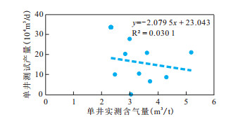
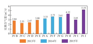


2019, 44(3): 1012-1023.
doi: 10.3799/dqkx.2018.389
Abstract:
Research on the shale oil enrichment mechanism of Qianjiang Formation is lacking.The data of core image, rock pyrolysis, vitrinite reflectance, biomarkers, maceral composition, rock petrophysics, well logging, and XPT well test were used to analyze the quality of source rock, reservoir property, and preservation condition in this study.The kerogens are predominantly type Ⅰ-Ⅱ1.The vitrinite reflectance ranges from 0.51% to 0.80%.The maturity indicators of C29 sterane in the rocks from the 10th cyclotherm in the Wangchang are obviously different from that of the underlying halite, which indicates that there are migrated oil.The porosity of the reservoir ranges from 7.8% to 26.3%.The halite layers are thick enough (> 6 m) and stable throughout the area distribution; moreover, they did not break during the stage of deposition and burial.With the excellent preservation condition and storage capacity, the hydrocarbon generated from the deeper source rocks within the 10th cyclotherm controlled the shale oil enrichment in higher structural position, while hydrocarbon generated in-situ dominated in the lower structural position.
Research on the shale oil enrichment mechanism of Qianjiang Formation is lacking.The data of core image, rock pyrolysis, vitrinite reflectance, biomarkers, maceral composition, rock petrophysics, well logging, and XPT well test were used to analyze the quality of source rock, reservoir property, and preservation condition in this study.The kerogens are predominantly type Ⅰ-Ⅱ1.The vitrinite reflectance ranges from 0.51% to 0.80%.The maturity indicators of C29 sterane in the rocks from the 10th cyclotherm in the Wangchang are obviously different from that of the underlying halite, which indicates that there are migrated oil.The porosity of the reservoir ranges from 7.8% to 26.3%.The halite layers are thick enough (> 6 m) and stable throughout the area distribution; moreover, they did not break during the stage of deposition and burial.With the excellent preservation condition and storage capacity, the hydrocarbon generated from the deeper source rocks within the 10th cyclotherm controlled the shale oil enrichment in higher structural position, while hydrocarbon generated in-situ dominated in the lower structural position.


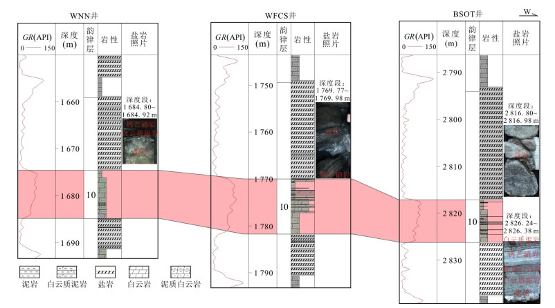

2019, 44(3): 1024-1041.
doi: 10.3799/dqkx.2018.381
Abstract:
Helium is a kind of important strategic scarce resources, which is related to national security and the development of high-tech industries.However, China is poor in helium and most of it depends on imports.The situation of resources security is very serious, so it is very important to carry out helium resources survey.Based on the investigation of helium resources in the seven major petroliferous basins and other areas in China, it can be concluded that the helium in natural gas in petroliferous basins in central and western China is radioactive origin from crust.Its enrichment is controlled by the distribution of acid rock or basement rich in U and Th, structural traps and fracture.The helium in the petroliferous basins located on both sides of Tanlu fault zone in eastern China is originated from the mixing of mantle and crustal sources.Its enrichment is controlled obviously by fracture.The high content of helium in water-soluble gas in geothermal water or hot springs is mainly crustal source.In this study, the Hetianhe gas field and its peripheral areas in Tarim Basin with good helium display but uncertainties are selected for the systematic exploration of helium resources.Through fine sampling and analysis of the 11 natural gas samples from Hetianhe gas field and its peripheral areas, it is found for the first time that Hetianhe gas field is rich in helium, with helium volume content ranging from 0.30% to 0.37%(average 0.32%).As originated from crust, the proven reserve of helium gas is 1.959 1×10⁸m3.So, Hetianhe gas field is the first supergiant helium-rich gas field discovered in China.Therefore, in this paper it is suggested that:(1) accelerating the construction of helium separation and liquefaction units in Hetianhe gas field to maximize the overall benefits; (2) demonstrating the feasibility of constructing "Tarim Basin helium strategic reserve base" as soon as possible, and carrying out systematic investigation of helium resources in petroliferous basins throughout the country; (3) strengthening the theoretical study of helium accumulation to guide helium resources exploration.
Helium is a kind of important strategic scarce resources, which is related to national security and the development of high-tech industries.However, China is poor in helium and most of it depends on imports.The situation of resources security is very serious, so it is very important to carry out helium resources survey.Based on the investigation of helium resources in the seven major petroliferous basins and other areas in China, it can be concluded that the helium in natural gas in petroliferous basins in central and western China is radioactive origin from crust.Its enrichment is controlled by the distribution of acid rock or basement rich in U and Th, structural traps and fracture.The helium in the petroliferous basins located on both sides of Tanlu fault zone in eastern China is originated from the mixing of mantle and crustal sources.Its enrichment is controlled obviously by fracture.The high content of helium in water-soluble gas in geothermal water or hot springs is mainly crustal source.In this study, the Hetianhe gas field and its peripheral areas in Tarim Basin with good helium display but uncertainties are selected for the systematic exploration of helium resources.Through fine sampling and analysis of the 11 natural gas samples from Hetianhe gas field and its peripheral areas, it is found for the first time that Hetianhe gas field is rich in helium, with helium volume content ranging from 0.30% to 0.37%(average 0.32%).As originated from crust, the proven reserve of helium gas is 1.959 1×10⁸m3.So, Hetianhe gas field is the first supergiant helium-rich gas field discovered in China.Therefore, in this paper it is suggested that:(1) accelerating the construction of helium separation and liquefaction units in Hetianhe gas field to maximize the overall benefits; (2) demonstrating the feasibility of constructing "Tarim Basin helium strategic reserve base" as soon as possible, and carrying out systematic investigation of helium resources in petroliferous basins throughout the country; (3) strengthening the theoretical study of helium accumulation to guide helium resources exploration.


2019, 44(3): 1042-1056.
doi: 10.3799/dqkx.2018.387
Abstract:
The study of the genetic mechanism of geothermal field is beneficial to the fine evaluation and effective development of geothermal field resources.On the basis of previous research results and the latest geothermal drilling data, the conceptual model of the formation of Xiwenzhuang geothermal field is established through analysis of main factors of "source, reservoir, migration channel and cover" of the karst geothermal system in Taiyuan Basin, and geothermal resources are carefully evaluated.It is considered that the Xiwenzhuang geothermal field formatted a middle-low temperature conducting geothermal system whose heat source results from the high terrestrial heat flow of asymmetric rift basin, whose recharge water source comes from the atmospheric precipitation in the exposed area of Ordovician karst reservoir in Dongshan and Xishan, and whose migration channels are the karst unconformity surface and fractures by which karst water migrated through the boundary faults of Dongshan and Xishan into the deep geothermal reservoir of the basin from Dongshan and Xishan bidirectional recharge, and after endothermic and temperature-increasing, gradually enriched and confined in the Ordovician karst reservoir of the Xiwenzhuang uplift in the central part of the basin.This geothermal system is characterized by better sealing performance, more aquifers of geothermal reservoir, faster recharge speed and higher geothermal gradient.In detail, the Ordovician karstic reservoir's cap rocks resulting in the buried depth of 800-1 700 m constitute of Carboniferous, Permian, Triassic and Quaternary.From top to bottom, the four main aquifers of Fengfeng Formation, Upper Majiagou Formation, Lower Majiagou Formation and Liangjiashan Formation are developed in turn.The average effective thickness of the thermal reservoir is 184.6 m in total, the migration age from the recharge source area to the confined area of basin is about 2 000 a, the average geothermal gradient of the overlying strata of the Ordovician geothermal reservoir is 3.0-4.0℃/100 m, and the geothermal water temperature range is 55-75℃.According to the fine evaluation results of geothermal resources of Ordovician karstic reservoir, the total geothermal reserve is 33.53×10⁸ GJ, which is equivalent to 1.14×10⁸ t of standard coal.The annual exploitation of geothermal resources can meet the demand of indoor heating area of 6.07 million square meters with huge potential for development.
The study of the genetic mechanism of geothermal field is beneficial to the fine evaluation and effective development of geothermal field resources.On the basis of previous research results and the latest geothermal drilling data, the conceptual model of the formation of Xiwenzhuang geothermal field is established through analysis of main factors of "source, reservoir, migration channel and cover" of the karst geothermal system in Taiyuan Basin, and geothermal resources are carefully evaluated.It is considered that the Xiwenzhuang geothermal field formatted a middle-low temperature conducting geothermal system whose heat source results from the high terrestrial heat flow of asymmetric rift basin, whose recharge water source comes from the atmospheric precipitation in the exposed area of Ordovician karst reservoir in Dongshan and Xishan, and whose migration channels are the karst unconformity surface and fractures by which karst water migrated through the boundary faults of Dongshan and Xishan into the deep geothermal reservoir of the basin from Dongshan and Xishan bidirectional recharge, and after endothermic and temperature-increasing, gradually enriched and confined in the Ordovician karst reservoir of the Xiwenzhuang uplift in the central part of the basin.This geothermal system is characterized by better sealing performance, more aquifers of geothermal reservoir, faster recharge speed and higher geothermal gradient.In detail, the Ordovician karstic reservoir's cap rocks resulting in the buried depth of 800-1 700 m constitute of Carboniferous, Permian, Triassic and Quaternary.From top to bottom, the four main aquifers of Fengfeng Formation, Upper Majiagou Formation, Lower Majiagou Formation and Liangjiashan Formation are developed in turn.The average effective thickness of the thermal reservoir is 184.6 m in total, the migration age from the recharge source area to the confined area of basin is about 2 000 a, the average geothermal gradient of the overlying strata of the Ordovician geothermal reservoir is 3.0-4.0℃/100 m, and the geothermal water temperature range is 55-75℃.According to the fine evaluation results of geothermal resources of Ordovician karstic reservoir, the total geothermal reserve is 33.53×10⁸ GJ, which is equivalent to 1.14×10⁸ t of standard coal.The annual exploitation of geothermal resources can meet the demand of indoor heating area of 6.07 million square meters with huge potential for development.