


2019 Vol. 44, No. 8
column
- The Exploration and Development Practice of Oil and Gas Accumulation Mechanism in High Tem perature, Overpressure and Deep Water Areas of Ying-Qiong Basin
- The Exploration and Development Practice of Oil and Gas Accumulation Mechanism in High Temperature, Overpressure and Deep Water Areas of Ying-Qiong Basin
Display Method:
 PDF 280KB
2019, 44(8): 2579-2589.
doi: 10.3799/dqkx.2019.095
Abstract:
Yinggehai Basin is the important Cenozoic petroliferous basin in China South Sea. With the gradual improvement of the petroleum exploration and development in shallow layers,middle and deep overpressured layers become the main target of the natural gas exploration. Whether the caprocks can effectively seal the oil and gas turns to be a crucial questions for the research. In recent years,different scholars have conducted a lot of researches on the caprocks of Yinggehai Baisn,but there are still some questions in the sealing mechanism,failure conditions and quantitative evaluation of the caprocks in high temperature and pressure. Based on the systematic analysis of the high temperature and pressure caprocks in Yinggehai Basin,it is clear that the sealing mechanism of caprocks is capillary sealing and hydraulic sealing. Using the relationship among displacement pressure,acoustic time and porosity of mudstone to predict the capillary sealing ability of regional caprocks,the results show that the caprocks in Yinggehai Basin have strong capillary sealing ability. Therefore,hydraulic fractures induced by overpressure are the fundamental cause of oil and gas multilayer accumulation,and then propose the cap hydraulic fracturing pressure coefficient to quantitative evaluate the risk of hydraulic fracturing in caprocks. The evaluation results show that there is a significant correlation between the occurrence of hydraulic fracturing in the caprock and the diapir activity,the risk of hydraulic fracturing in caprocks gradually decreases from the diapiric center to the periphery. LD-B block located in the slope near the depression in Yinggehai Basin which is adjacent to the Ledong diapirs,is a favorable area for oil and gas accumulation.
Yinggehai Basin is the important Cenozoic petroliferous basin in China South Sea. With the gradual improvement of the petroleum exploration and development in shallow layers,middle and deep overpressured layers become the main target of the natural gas exploration. Whether the caprocks can effectively seal the oil and gas turns to be a crucial questions for the research. In recent years,different scholars have conducted a lot of researches on the caprocks of Yinggehai Baisn,but there are still some questions in the sealing mechanism,failure conditions and quantitative evaluation of the caprocks in high temperature and pressure. Based on the systematic analysis of the high temperature and pressure caprocks in Yinggehai Basin,it is clear that the sealing mechanism of caprocks is capillary sealing and hydraulic sealing. Using the relationship among displacement pressure,acoustic time and porosity of mudstone to predict the capillary sealing ability of regional caprocks,the results show that the caprocks in Yinggehai Basin have strong capillary sealing ability. Therefore,hydraulic fractures induced by overpressure are the fundamental cause of oil and gas multilayer accumulation,and then propose the cap hydraulic fracturing pressure coefficient to quantitative evaluate the risk of hydraulic fracturing in caprocks. The evaluation results show that there is a significant correlation between the occurrence of hydraulic fracturing in the caprock and the diapir activity,the risk of hydraulic fracturing in caprocks gradually decreases from the diapiric center to the periphery. LD-B block located in the slope near the depression in Yinggehai Basin which is adjacent to the Ledong diapirs,is a favorable area for oil and gas accumulation.


2019, 44(8): 2590-2596.
doi: 10.3799/dqkx.2019.140
Abstract:
The fault system in the Zhusan Sag area of the western South China Sea is complex. The seismic data acquired at different exploration stages has a narrow azimuth,and it is difficult to image the complex fracture zones. The seismic data with different azimuths in the same batch need higher operation technology and higher cost.In order to achieve the purpose of wide-azimuth seismic imaging,3D seismic data acquired in different orientations in different years can be combined with advanced multiple suppression technology and seismic fusion technology to indirectly form a wide-azimuth 3D seismic data. This operation will greatly reduce the acquisition cost. The comparison and analysis of the actual imaging effect indicate this method can better improve the imaging effect of the complex fracture zone.
The fault system in the Zhusan Sag area of the western South China Sea is complex. The seismic data acquired at different exploration stages has a narrow azimuth,and it is difficult to image the complex fracture zones. The seismic data with different azimuths in the same batch need higher operation technology and higher cost.In order to achieve the purpose of wide-azimuth seismic imaging,3D seismic data acquired in different orientations in different years can be combined with advanced multiple suppression technology and seismic fusion technology to indirectly form a wide-azimuth 3D seismic data. This operation will greatly reduce the acquisition cost. The comparison and analysis of the actual imaging effect indicate this method can better improve the imaging effect of the complex fracture zone.


2019, 44(8): 2597-2602.
doi: 10.3799/dqkx.2019.049
Abstract:
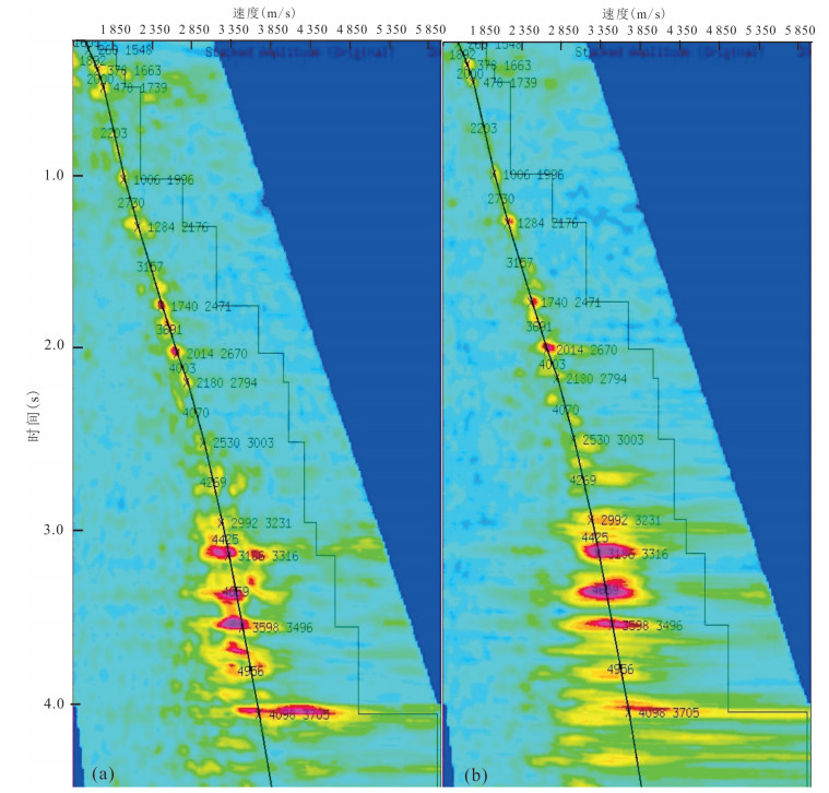
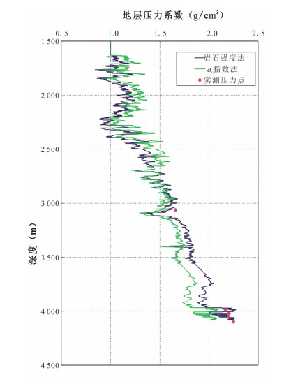
With the deepening exploration of oil and gas in deepwater with high temperature and high pressure conditions,there are various reservoir systems,which are complex and interlaced. Downhole complications occur frequently in the drilling process,which seriously affects the drilling safety.In this paper,combined the drilling example of deepwater with high temperature and high pressure well X1,dC index method and rock strength method are used to monitor formation pressure while drilling.The results show that the rock strength method is more accurate for pressure monitoring of deepwater with high temperature and high pressure wells,and it can provide a reference for subsequent monitoring of formation pressure in deepwater with high temperature and high pressure wells.
With the deepening exploration of oil and gas in deepwater with high temperature and high pressure conditions,there are various reservoir systems,which are complex and interlaced. Downhole complications occur frequently in the drilling process,which seriously affects the drilling safety.In this paper,combined the drilling example of deepwater with high temperature and high pressure well X1,dC index method and rock strength method are used to monitor formation pressure while drilling.The results show that the rock strength method is more accurate for pressure monitoring of deepwater with high temperature and high pressure wells,and it can provide a reference for subsequent monitoring of formation pressure in deepwater with high temperature and high pressure wells.

2019, 44(8): 2603-2608.
doi: 10.3799/dqkx.2019.087
Abstract:
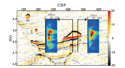
With the extension of exploration in Qiongdongnan(QDN) Basin to deep water area,the seismic data amplitude is poorly preserved due to the large variation of water depth and the influence of spherical diffusion compensation,etc.The evaluation of oil and gas in different targets is affected by the difference of burial depth and water depth,and the analogy of amplitude attribute is poor. There are so many limitations in hydrocarbon detection only by bright spots technique.This paper is based on the theory of dual-phase medium.The seismic wave characteristics of oil and gas bearing reservoirs are explored.The strong attenuation of oil and gas reservoirs causes the seismic main frequency from high frequency to low frequency.Time-frequency analysis is using matching pursuit and high resolution Wigner distribution.Through accurate analysis of seismic wave spectrum difference before and after passing through oil and gas reservoirs,and application of main frequency shift characteristic attributes for oil and gas detection is obtained. Good exploration effect in deep water area of QDN Basin is achieved.At the same time,the technique does not depend on logging data and other factors,so it has great application prospects.
With the extension of exploration in Qiongdongnan(QDN) Basin to deep water area,the seismic data amplitude is poorly preserved due to the large variation of water depth and the influence of spherical diffusion compensation,etc.The evaluation of oil and gas in different targets is affected by the difference of burial depth and water depth,and the analogy of amplitude attribute is poor. There are so many limitations in hydrocarbon detection only by bright spots technique.This paper is based on the theory of dual-phase medium.The seismic wave characteristics of oil and gas bearing reservoirs are explored.The strong attenuation of oil and gas reservoirs causes the seismic main frequency from high frequency to low frequency.Time-frequency analysis is using matching pursuit and high resolution Wigner distribution.Through accurate analysis of seismic wave spectrum difference before and after passing through oil and gas reservoirs,and application of main frequency shift characteristic attributes for oil and gas detection is obtained. Good exploration effect in deep water area of QDN Basin is achieved.At the same time,the technique does not depend on logging data and other factors,so it has great application prospects.


2019, 44(8): 2609-2618.
doi: 10.3799/dqkx.2019.159
Abstract:
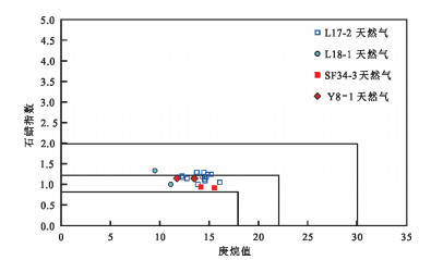
Based on the geochemical analyses of natural gases and seismic exploration data,the genesis,sources and lateral migration accumulation of Y8-1 bearing structure were comprehensively analyzed in the East deep water of the Qiongdong Basin. The analyses of C6,C7 light hydrocarbons show that the natural gas of the Y8-1 bearing structure is different from oil-type gas in the northern slope of Songdong sag,and coal-type gas of L17-2 gas field in the deepwater as well. According to the ethane and the propane carbon isotope,the natural gas in the Y8-1 bearing structurehas the mixing characteristics of coal-type gas and oil-type gas. The typical coal-type gas and the oil-type gas in the east Qiongdongnan Basin are selected to be end elements,the natural gas ethane carbon isotope of the Y8-1 bearing structure is calculated as coal-type gas for 53.3% and oil-type gas for 46.7% in the natural gas. The Y8-1 mixing source gas derived from the terrestrial marine source rock of Lower Oligocene Yacheng formation and Eocene lacustrine source rock in Songnan-Baodao sag respectively,and both sets of source rocks have geological conditions for the formation of mature-high mature natural gas. The natural gas generated from the source rocks in the Songnan,Baodao sags migrates along the tectonic ridges,faults,and sandstone carriers for a long distance,thenaccumulatedin the Yacheng formation and granite basement traps in the Songnan low-uplift,East deep water of the Qiongdong Basin.
Based on the geochemical analyses of natural gases and seismic exploration data,the genesis,sources and lateral migration accumulation of Y8-1 bearing structure were comprehensively analyzed in the East deep water of the Qiongdong Basin. The analyses of C6,C7 light hydrocarbons show that the natural gas of the Y8-1 bearing structure is different from oil-type gas in the northern slope of Songdong sag,and coal-type gas of L17-2 gas field in the deepwater as well. According to the ethane and the propane carbon isotope,the natural gas in the Y8-1 bearing structurehas the mixing characteristics of coal-type gas and oil-type gas. The typical coal-type gas and the oil-type gas in the east Qiongdongnan Basin are selected to be end elements,the natural gas ethane carbon isotope of the Y8-1 bearing structure is calculated as coal-type gas for 53.3% and oil-type gas for 46.7% in the natural gas. The Y8-1 mixing source gas derived from the terrestrial marine source rock of Lower Oligocene Yacheng formation and Eocene lacustrine source rock in Songnan-Baodao sag respectively,and both sets of source rocks have geological conditions for the formation of mature-high mature natural gas. The natural gas generated from the source rocks in the Songnan,Baodao sags migrates along the tectonic ridges,faults,and sandstone carriers for a long distance,thenaccumulatedin the Yacheng formation and granite basement traps in the Songnan low-uplift,East deep water of the Qiongdong Basin.


2019, 44(8): 2619-2626.
doi: 10.3799/dqkx.2019.141
Abstract:
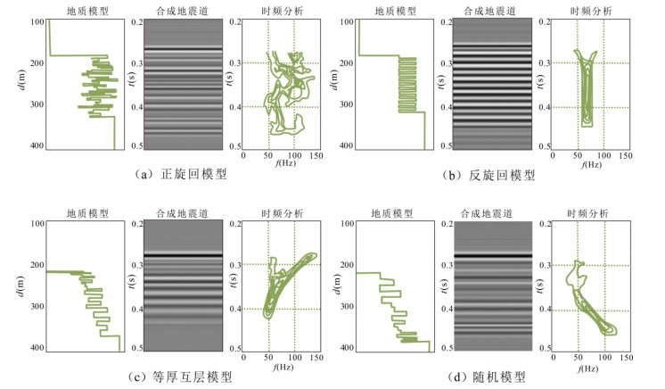
With the continuous progress of exploration,it has become a new development trend to find favorable oil and gas reservoir with weak amplitude reflection. In order to confirm the geological significance of weak amplitude reflection,the simulation of variable porosity has been carried out in Ledong (LD) area in this study,revealing the energy of seismic reflection decreases gradually with the increasing of sandstone porosity. It is confirmed in LD area that the weak amplitude may also be a sign of favorable reservoir. Combined with sedimentary rhythm,different models are established and the time-frequency spectrum is extracted. It is found that directionality of time-frequency characteristics is related to sedimentary association of strata,and the weak amplitude of the channel in LD area is similar to the time-frequency characteristics of the positive cyclic strata. There is a high probability that the weak amplitude in the channel is thick sandstone,which is confirmed by the drilling,showing that the technique is reliable. This study provides important guidance for deep oil and gas exploration and drilling target optimization in LD area.
With the continuous progress of exploration,it has become a new development trend to find favorable oil and gas reservoir with weak amplitude reflection. In order to confirm the geological significance of weak amplitude reflection,the simulation of variable porosity has been carried out in Ledong (LD) area in this study,revealing the energy of seismic reflection decreases gradually with the increasing of sandstone porosity. It is confirmed in LD area that the weak amplitude may also be a sign of favorable reservoir. Combined with sedimentary rhythm,different models are established and the time-frequency spectrum is extracted. It is found that directionality of time-frequency characteristics is related to sedimentary association of strata,and the weak amplitude of the channel in LD area is similar to the time-frequency characteristics of the positive cyclic strata. There is a high probability that the weak amplitude in the channel is thick sandstone,which is confirmed by the drilling,showing that the technique is reliable. This study provides important guidance for deep oil and gas exploration and drilling target optimization in LD area.


2019, 44(8): 2627-2635.
doi: 10.3799/dqkx.2019.202
Abstract:
The deep water area of the Qiongdongnan Basin is currently a hot spot for natural gas exploration,but the lack of understanding of sedimentary model、evolution characteristics of the source rocks constrains the exploration results. In order to identify and evaluate source rocks in the deep waters of the Qiongdongnan Basin,Comprehensive application of seismic sedimentology,organic geochemistry and structural geology analysis methods,the parent materials of hydrocarbon and formation settings of the Oligocene-containing coal delta-shallow marine mudstones and their corresponding relationships with the discovered oil and gas are analyzed. The research shows that the distribution of coal-series and terrigenous type dominated marine source rocks controlled by the development scale and paleo-geomorphology of the Oligocene delta,and semi-closed shallow sea environment in the transition period of the fault-depression is conducive to formed the Oligocene terrestrial marine source rocks which are characterized by gas-prone and oil coproduct; The terrigenous type dominated marine source rocks distribution、thermal evolution as well as hydrocarbon generation processes of deep water have controlled the characteristics of natural gas potential. Hereby,gas-prone sags are evaluated by classification and Ledong、Lingshui and Songnan are gas- rich sags of Ⅰtype.
The deep water area of the Qiongdongnan Basin is currently a hot spot for natural gas exploration,but the lack of understanding of sedimentary model、evolution characteristics of the source rocks constrains the exploration results. In order to identify and evaluate source rocks in the deep waters of the Qiongdongnan Basin,Comprehensive application of seismic sedimentology,organic geochemistry and structural geology analysis methods,the parent materials of hydrocarbon and formation settings of the Oligocene-containing coal delta-shallow marine mudstones and their corresponding relationships with the discovered oil and gas are analyzed. The research shows that the distribution of coal-series and terrigenous type dominated marine source rocks controlled by the development scale and paleo-geomorphology of the Oligocene delta,and semi-closed shallow sea environment in the transition period of the fault-depression is conducive to formed the Oligocene terrestrial marine source rocks which are characterized by gas-prone and oil coproduct; The terrigenous type dominated marine source rocks distribution、thermal evolution as well as hydrocarbon generation processes of deep water have controlled the characteristics of natural gas potential. Hereby,gas-prone sags are evaluated by classification and Ledong、Lingshui and Songnan are gas- rich sags of Ⅰtype.


2019, 44(8): 2636-2642.
doi: 10.3799/dqkx.2019.035
Abstract:
A large number of high temperature,high pressure and high carbon dioxide gas reservoirs exist in the western South China Sea. Gas well test cost is high and productivity prediction is difficult in "three high" gas reservoir. Design Variable internal pressure,establishment of irreducible water stress sensitivity test and PVT test of natural gas Containing CO2 to study the effect of stress sensitivity,CO2 content and skin factor on productivity of high temperature and high pressure gas wells. Through a large number of experiments,the "two-stage" stress sensitivity variation law of high pressure gas reservoir is clarified,and the comprehensive evaluation coefficient of stress sensitivity in target area is obtained. The influence of CO2 content on PVT parameters such as Z-factor and viscosity of natural gas is analyzed,the influence of high pressure is greater than that of low pressure. Based on experimental data,a correction model of full range deviation coefficient suitable for high,middle and low carbon dioxide content is established. Finally,a regional productivity prediction chart considering the influence of reservoir stress-sensitivity,carbon dioxide and skin factor is established,improves the accuracy of productivity prediction and reduces the cost of testing,which has a good application effect in high temperature and high pressure gas wells in the western South China Sea.
A large number of high temperature,high pressure and high carbon dioxide gas reservoirs exist in the western South China Sea. Gas well test cost is high and productivity prediction is difficult in "three high" gas reservoir. Design Variable internal pressure,establishment of irreducible water stress sensitivity test and PVT test of natural gas Containing CO2 to study the effect of stress sensitivity,CO2 content and skin factor on productivity of high temperature and high pressure gas wells. Through a large number of experiments,the "two-stage" stress sensitivity variation law of high pressure gas reservoir is clarified,and the comprehensive evaluation coefficient of stress sensitivity in target area is obtained. The influence of CO2 content on PVT parameters such as Z-factor and viscosity of natural gas is analyzed,the influence of high pressure is greater than that of low pressure. Based on experimental data,a correction model of full range deviation coefficient suitable for high,middle and low carbon dioxide content is established. Finally,a regional productivity prediction chart considering the influence of reservoir stress-sensitivity,carbon dioxide and skin factor is established,improves the accuracy of productivity prediction and reduces the cost of testing,which has a good application effect in high temperature and high pressure gas wells in the western South China Sea.


2019, 44(8): 2643-2653.
doi: 10.3799/dqkx.2019.091
Abstract:
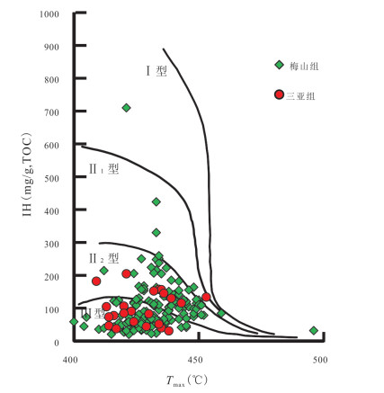
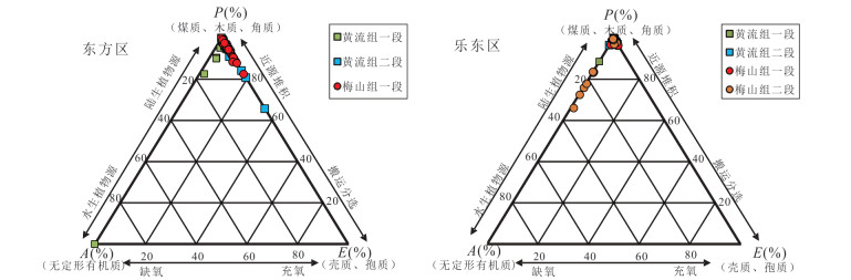
In order to find out the formation mechanism of organic matter in marine source rocks of Yinggehai Basin, the geobiological methods were introduced to evaluate the dynamic process of the hydrocarbon source rocks, which can make up for the poor sample conditions of the basin. Combined with organic geochemical methods, the formation mechanism of organic matter in marine source rocks of Yinggehai Basin was studied comprehensively and the development model of source rocks was established. The study shows that shallow marine source rocks are developed in the Miocene of Yinggehai Basin. The organic matter type is mainly type Ⅱ2-Ⅲ, which is the mixed source rock. Most of the Miocene source rocks in the depression are in the high-mature to over-mature stage. Marine source rocks are mainly controlled by paleoproductivity and preservation conditions. In plane, the development conditions of Miocene source rocks in the Dongfang area of Yinggehai Basin are better than those in Ledong area. Vertically, favorable source rocks maybe distribute in Meishan formation. The research results provide an important basis for recognizing the formation mechanism of source rocks and accurately evaluating their resource potential in the Yinggehai Basin.
In order to find out the formation mechanism of organic matter in marine source rocks of Yinggehai Basin, the geobiological methods were introduced to evaluate the dynamic process of the hydrocarbon source rocks, which can make up for the poor sample conditions of the basin. Combined with organic geochemical methods, the formation mechanism of organic matter in marine source rocks of Yinggehai Basin was studied comprehensively and the development model of source rocks was established. The study shows that shallow marine source rocks are developed in the Miocene of Yinggehai Basin. The organic matter type is mainly type Ⅱ2-Ⅲ, which is the mixed source rock. Most of the Miocene source rocks in the depression are in the high-mature to over-mature stage. Marine source rocks are mainly controlled by paleoproductivity and preservation conditions. In plane, the development conditions of Miocene source rocks in the Dongfang area of Yinggehai Basin are better than those in Ledong area. Vertically, favorable source rocks maybe distribute in Meishan formation. The research results provide an important basis for recognizing the formation mechanism of source rocks and accurately evaluating their resource potential in the Yinggehai Basin.


2019, 44(8): 2654-2664.
doi: 10.3799/dqkx.2019.108
Abstract:
The main exploration strata are gravity flow deposits and high temperature and overpressure reservoirs with silty, fine, medium and coarse sandstone, and with physical characteristics of medium, low and ultra-low permeability, from the Miocene Huangliu-Meishan Formation in the central depression of Ying-Qiong Basin in the northern South China Sea. By studying the characteristics of high temperature and overpressure reservoirs, the formation mechanism of favorable reservoir is determined, which provides geological basis for evaluation of key areas. From Dongfang to Ledong to Ledong-Lingshui Depression, from the slope area of the sag to the center of the sag, the depth is deepened in each diagenesis period because of differences in the geothermal gradient and the formation time and development intensity, of abnormal overpressure, however, the porosity decreases slightly in the longitudinal direction, which is obviously different from the atmospheric reservoir in the slope area. Favorable reservoirs are controlled by the grain size and mudstone matrix of reservoir rock controlled by sedimentary environment, and diagenesis controlled by high temperature, overpressure and thermal fluid.The submarine fan reservoir with overpressure protection is favorable in the center of sag. The medium permeability "sweet spot" reservoir is developed with a large number of secondary pores formed by thermal fluids in the slope.
The main exploration strata are gravity flow deposits and high temperature and overpressure reservoirs with silty, fine, medium and coarse sandstone, and with physical characteristics of medium, low and ultra-low permeability, from the Miocene Huangliu-Meishan Formation in the central depression of Ying-Qiong Basin in the northern South China Sea. By studying the characteristics of high temperature and overpressure reservoirs, the formation mechanism of favorable reservoir is determined, which provides geological basis for evaluation of key areas. From Dongfang to Ledong to Ledong-Lingshui Depression, from the slope area of the sag to the center of the sag, the depth is deepened in each diagenesis period because of differences in the geothermal gradient and the formation time and development intensity, of abnormal overpressure, however, the porosity decreases slightly in the longitudinal direction, which is obviously different from the atmospheric reservoir in the slope area. Favorable reservoirs are controlled by the grain size and mudstone matrix of reservoir rock controlled by sedimentary environment, and diagenesis controlled by high temperature, overpressure and thermal fluid.The submarine fan reservoir with overpressure protection is favorable in the center of sag. The medium permeability "sweet spot" reservoir is developed with a large number of secondary pores formed by thermal fluids in the slope.


2019, 44(8): 2665-2676.
doi: 10.3799/dqkx.2019.097
Abstract:
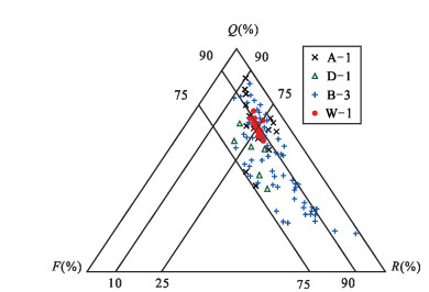
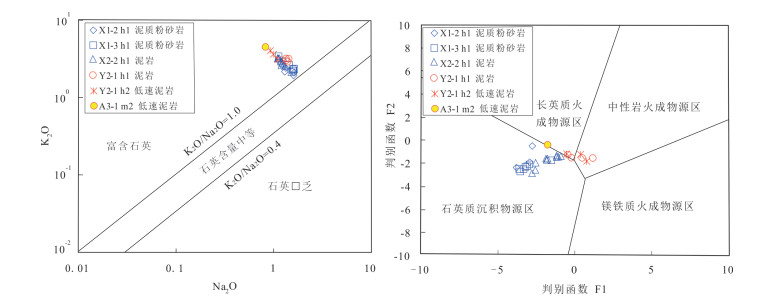
Sandstone reservoirs of Lingshui formation in Baodao-Changchang depression are currently the key targets for oil and gas exploration in Qiongdongnan Basin. In this paper, the differences of diagenesis evolution in sandstone reservoirs of Lingshui formation between the northern slope of Baodao sag and Changchang sag are studied by means of casting thin sections, laser particle size, element geochemistry, X-ray diffraction, scanning electron microscopy, fluid inclusions and electron probe analysis. The results show that the sandstone reservoirs on the northern slope of Baodao sag are delta deposits under the provenance system of Hainan Island which have strong hydrodynamic characteristics of "coarse grain size and high stable component", while the sandstone reservoirs in Changchang sag have weak hydrodynamic characteristics of "fine grain size and heavy argillaceous", which are submarine fan deposits under the provenance system of Shenhu uplift and Xisha uplift. Mechanical compaction results in linear or convex contact of sandstone particles in Lingshui formation in the northern slope of Baodao sag. The high heat flow leads to the chemical compaction stage of sandstone in Lingshui formation of Changchang depression under the condition of shallow burial below sea floor (about an depth of 1 400 m below sea floor) and point-line contact of particles, accompanied by hydrothermal minerals such as barite and dawsonite. There are two stages of hydrocarbon filling (14.5~10.0 Ma, 2~0 Ma) in the northern slope of Baodao sag, which were separated by one stage of CO2 filling (7~3 Ma). In Changchang sag, only early hydrocarbon filling (14.5~6.0 Ma) and subsequent CO2 filling (5~0 Ma) were developed. The evolution of sandstone reservoirs in Lingshui Formation on the northern slope of Baodao Sag was generally characterized by "slowly deep-buried below sea floor and slow temperature rise". Natural gas filling promoted dissolution and inhibits cementation, while Changchang Sag was characterized by " shallow-buried below sea floor and rapid temperature rise" and continuous CO2 filling promoted cementation of carbonate or clay or hydrothermal minerals.
Sandstone reservoirs of Lingshui formation in Baodao-Changchang depression are currently the key targets for oil and gas exploration in Qiongdongnan Basin. In this paper, the differences of diagenesis evolution in sandstone reservoirs of Lingshui formation between the northern slope of Baodao sag and Changchang sag are studied by means of casting thin sections, laser particle size, element geochemistry, X-ray diffraction, scanning electron microscopy, fluid inclusions and electron probe analysis. The results show that the sandstone reservoirs on the northern slope of Baodao sag are delta deposits under the provenance system of Hainan Island which have strong hydrodynamic characteristics of "coarse grain size and high stable component", while the sandstone reservoirs in Changchang sag have weak hydrodynamic characteristics of "fine grain size and heavy argillaceous", which are submarine fan deposits under the provenance system of Shenhu uplift and Xisha uplift. Mechanical compaction results in linear or convex contact of sandstone particles in Lingshui formation in the northern slope of Baodao sag. The high heat flow leads to the chemical compaction stage of sandstone in Lingshui formation of Changchang depression under the condition of shallow burial below sea floor (about an depth of 1 400 m below sea floor) and point-line contact of particles, accompanied by hydrothermal minerals such as barite and dawsonite. There are two stages of hydrocarbon filling (14.5~10.0 Ma, 2~0 Ma) in the northern slope of Baodao sag, which were separated by one stage of CO2 filling (7~3 Ma). In Changchang sag, only early hydrocarbon filling (14.5~6.0 Ma) and subsequent CO2 filling (5~0 Ma) were developed. The evolution of sandstone reservoirs in Lingshui Formation on the northern slope of Baodao Sag was generally characterized by "slowly deep-buried below sea floor and slow temperature rise". Natural gas filling promoted dissolution and inhibits cementation, while Changchang Sag was characterized by " shallow-buried below sea floor and rapid temperature rise" and continuous CO2 filling promoted cementation of carbonate or clay or hydrothermal minerals.


2019, 44(8): 2677-2685.
doi: 10.3799/dqkx.2019.176
Abstract:
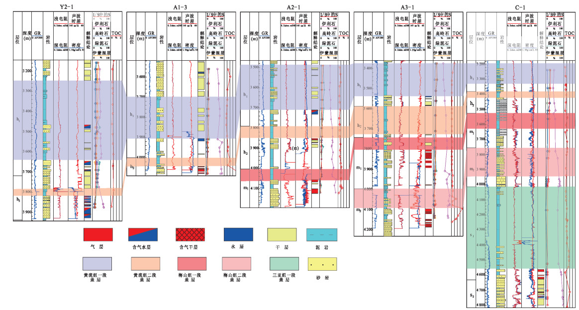
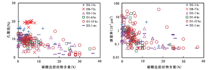
Commercial gas fields have been discovered in Dongfang-Ledong area of Yinggehai Basin, but little research has been done on gas field caprock, especially on mudstone caprock type and pore throat structure. In this paper, the mineral composition, geochemistry, diagenetic evolution and pore structure characteristics of mudstone in the area are studied in depth by using the data of thin sections, geochemistry, XRD and element analysis.The results show that the distribution of mudstone caprocks in the first and second members of the Mesozoic Huangliu Formation in Dongfang-Ledong area of Yinggehai Basin is the most stable, and the caprocks are greatly influenced by terrigenousclastic supply and calcareous fossil fragments. The content of terrigenousclastic particles and calcareous fossil fragments in the high-quality caprocks in the study area is low, and secondary dissolution pore and micro-fracture are not developed.Dehydration of clay minerals during burial diagenesis and hydrocarbon expulsion by thermal evolution of organic matter are the main genesis of low-velocity mudstones. Mudstone caprock is dominated by microporous throat and ultraporousthroat, which is not conducive to gas seepage and obviously hinders the upward escape of oil and gas, and the overall sealing of caprock is good.
Commercial gas fields have been discovered in Dongfang-Ledong area of Yinggehai Basin, but little research has been done on gas field caprock, especially on mudstone caprock type and pore throat structure. In this paper, the mineral composition, geochemistry, diagenetic evolution and pore structure characteristics of mudstone in the area are studied in depth by using the data of thin sections, geochemistry, XRD and element analysis.The results show that the distribution of mudstone caprocks in the first and second members of the Mesozoic Huangliu Formation in Dongfang-Ledong area of Yinggehai Basin is the most stable, and the caprocks are greatly influenced by terrigenousclastic supply and calcareous fossil fragments. The content of terrigenousclastic particles and calcareous fossil fragments in the high-quality caprocks in the study area is low, and secondary dissolution pore and micro-fracture are not developed.Dehydration of clay minerals during burial diagenesis and hydrocarbon expulsion by thermal evolution of organic matter are the main genesis of low-velocity mudstones. Mudstone caprock is dominated by microporous throat and ultraporousthroat, which is not conducive to gas seepage and obviously hinders the upward escape of oil and gas, and the overall sealing of caprock is good.


2019, 44(8): 2686-2694.
doi: 10.3799/dqkx.2019.154
Abstract:
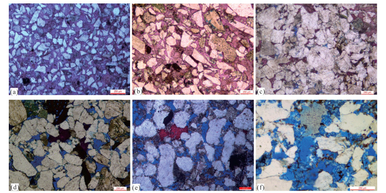
In order to explore the distribution law, formation mechanism and its effect on reservoir quality in Ledong District, a comprehensive study of petrology and geochemistry was carried out on the characteristics of cast thin sections, carbon and oxygen isotopes, and inclusions of carbonate cement. The results show that the carbonate cement content from the slope to the depression center has been reduced from 18.0% to 5.0%, and its δ13C value is distributed in the range of -4.78‰~+1.03‰, the δ18O value is distributed in the range of -10.99‰ to -6.34‰, Z Values range from 111.27 to 123.59, ancient sea water temperature is distributed in the range of 11.36℃ to 32.02℃, ancient salinity is distributed in the range of 3.24% to 6.91%. It is found that the formation of carbonate cement is mainly related to the dissolution and precipitation of carbonate rock or high calcareous sandstone, which is controlled by the water medium temperature, the formation temperature and salinity. From the slope to the depression center, the water medium temperature is reduced, the salinity is increased, and the bond is weak. Low-content early (iron) calcite and high temperature hot fluid dissolved early (iron) calcite produced by low or high content of late (iron) dolomite areas can develop medium-permeability "sweet spot" reservoirs.
In order to explore the distribution law, formation mechanism and its effect on reservoir quality in Ledong District, a comprehensive study of petrology and geochemistry was carried out on the characteristics of cast thin sections, carbon and oxygen isotopes, and inclusions of carbonate cement. The results show that the carbonate cement content from the slope to the depression center has been reduced from 18.0% to 5.0%, and its δ13C value is distributed in the range of -4.78‰~+1.03‰, the δ18O value is distributed in the range of -10.99‰ to -6.34‰, Z Values range from 111.27 to 123.59, ancient sea water temperature is distributed in the range of 11.36℃ to 32.02℃, ancient salinity is distributed in the range of 3.24% to 6.91%. It is found that the formation of carbonate cement is mainly related to the dissolution and precipitation of carbonate rock or high calcareous sandstone, which is controlled by the water medium temperature, the formation temperature and salinity. From the slope to the depression center, the water medium temperature is reduced, the salinity is increased, and the bond is weak. Low-content early (iron) calcite and high temperature hot fluid dissolved early (iron) calcite produced by low or high content of late (iron) dolomite areas can develop medium-permeability "sweet spot" reservoirs.


2019, 44(8): 2695-2703.
doi: 10.3799/dqkx.2019.106
Abstract:
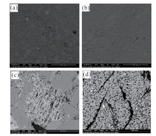
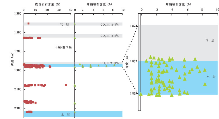
It has been proved that there is a great relationship between the genesis of dawsonite and the injection of CO2, while dawsonite, the trace mineral of CO2, is developed in the Yinggehai-Huangliu Formation, Ledong Area, Yinggehai Basin. Petrologic and isotopic geochemical characteristics were investigated by polarizing microscope, scanning electron microscope (SEM) and carbon-oxygen isotopic analysis. The diagenesis sequence indicates that dawsonite and ankerite formed after CO2 flooding, meanwhile, the carbon-oxygen isotopic analyses show that the mantle-magmatic CO2 provided the carbon sources for the deposite of dawsonite. Thereby, it can be deduced that, CO2 in gas reservoir and CO2 which for dawsonite genesis had the same carbon source, both of which had got the contribution from the mantle-magmatic CO2. The migration pathway for the mantle CO2 might be the Red River fault zone and the central diaper structures in Ledong Area, Yinggehai Basin. The longitudinal distribution characteristics of dawsonite, which mainly developed in the interface between gas (with high CO2 content) and water layer, provide the geological evidence showing that water is essential for the interaction between CO2 and the minerals.
It has been proved that there is a great relationship between the genesis of dawsonite and the injection of CO2, while dawsonite, the trace mineral of CO2, is developed in the Yinggehai-Huangliu Formation, Ledong Area, Yinggehai Basin. Petrologic and isotopic geochemical characteristics were investigated by polarizing microscope, scanning electron microscope (SEM) and carbon-oxygen isotopic analysis. The diagenesis sequence indicates that dawsonite and ankerite formed after CO2 flooding, meanwhile, the carbon-oxygen isotopic analyses show that the mantle-magmatic CO2 provided the carbon sources for the deposite of dawsonite. Thereby, it can be deduced that, CO2 in gas reservoir and CO2 which for dawsonite genesis had the same carbon source, both of which had got the contribution from the mantle-magmatic CO2. The migration pathway for the mantle CO2 might be the Red River fault zone and the central diaper structures in Ledong Area, Yinggehai Basin. The longitudinal distribution characteristics of dawsonite, which mainly developed in the interface between gas (with high CO2 content) and water layer, provide the geological evidence showing that water is essential for the interaction between CO2 and the minerals.


2019, 44(8): 2704-2716.
doi: 10.3799/dqkx.2019.104
Abstract:
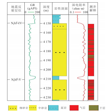
Based on the detailed interpretation of regional long section and the latest drilling, logging and seismic data, the Paleogene structural pattern, slope type and its evolution characteristics, sedimentary characteristics and their relationship with gas accumulation in Songnan low uplift (SLU)and surrounding areas are analyzed.The purpose is to clarify the tectonic and sedimentary evolution characteristics of the SLU and its influence on gas accumulation. The results show that the SLU is mainly controlled by the No.2 & No.12 faults in the north and No.11 & No.10 faults in the south. The SLU experienced two stages, namely, the differential updip uplift characterized by the "high in the west and low in the east " and the accelerated eastward updip uplift. And it was dominated by the development of rotational lift ramp in the Paleogene. The paleogeomorphology has the characteristics of "alternation of uplift and depression" and "high in the west and low in the east" in study area. The faults activity and uplift of upwarping controlled the distribution of material source area, sedimentary pattern of gentle slope and sand transport channel, so fans delta deposit developed in the gentle slope zone on the western bulge. The wide distribution of fan deltas formed high quality reservoir, and the tectonic activity formed many types of traps. The gas generation, transportation and accumulation are well matched in space and time in the SLU Therefore, the Paleogene of SLU is expected to be the next gas accumulation area of about 100 billion cubic meters in the Qiongnan Basin.
Based on the detailed interpretation of regional long section and the latest drilling, logging and seismic data, the Paleogene structural pattern, slope type and its evolution characteristics, sedimentary characteristics and their relationship with gas accumulation in Songnan low uplift (SLU)and surrounding areas are analyzed.The purpose is to clarify the tectonic and sedimentary evolution characteristics of the SLU and its influence on gas accumulation. The results show that the SLU is mainly controlled by the No.2 & No.12 faults in the north and No.11 & No.10 faults in the south. The SLU experienced two stages, namely, the differential updip uplift characterized by the "high in the west and low in the east " and the accelerated eastward updip uplift. And it was dominated by the development of rotational lift ramp in the Paleogene. The paleogeomorphology has the characteristics of "alternation of uplift and depression" and "high in the west and low in the east" in study area. The faults activity and uplift of upwarping controlled the distribution of material source area, sedimentary pattern of gentle slope and sand transport channel, so fans delta deposit developed in the gentle slope zone on the western bulge. The wide distribution of fan deltas formed high quality reservoir, and the tectonic activity formed many types of traps. The gas generation, transportation and accumulation are well matched in space and time in the SLU Therefore, the Paleogene of SLU is expected to be the next gas accumulation area of about 100 billion cubic meters in the Qiongnan Basin.


2019, 44(8): 2717-2728.
doi: 10.3799/dqkx.2019.186
Abstract:
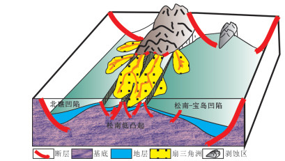
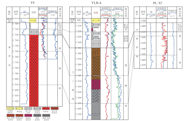
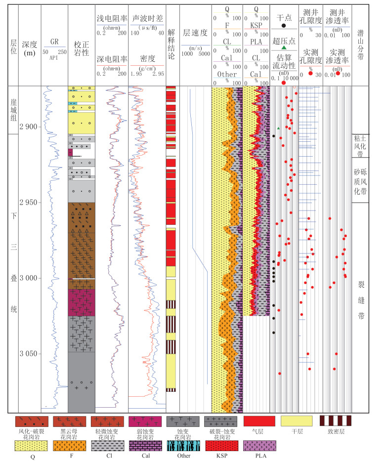
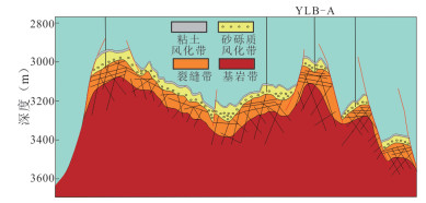
Study the reservoir characteristics and controlling factors of granite buried hillis the basis for further exploration of buried hill in Qiongdongnan Basin. Reservoir characteristics are studied by combining with Logging data, sidewall core, microphotograph, and geochemical data. It's found that the granite of Songnan low uplift was affected by long-term weathering and the vertical zoning is obvious. Clay weathering zone, gravel weathering zone, fracture zone and fresh bedrock zone are developed from the surface to the inside. The characteristics of basement weathering crust and longitudinal structure can be well identified by combining element logging, imaging logging and conventional logging. The Reservoir space characteristics of different weathering layers are significant differences.Four types of reservoir spaces are successively developed:pore, fracture-pore complex, pore-fracture complex and fracture type, The sandy gravel weathering zone dominated by fracture-pore reservoirs has the best physical properties. Below the sandy gravel weathering zone, as the burial depth increases, weathering weakens and reservoir physical properties deteriorate in turn and the reservoir physical properties getting worse. Long-term Paleo-high background and Faults development because of stress concentration release around Songnan low uplift, Thick weathering crust is developed. Shallow burial and weak diagenetic remake is the main reason for the development of weathering crust reservoir.Providing geological support for further exploration in buried hill area.
Study the reservoir characteristics and controlling factors of granite buried hillis the basis for further exploration of buried hill in Qiongdongnan Basin. Reservoir characteristics are studied by combining with Logging data, sidewall core, microphotograph, and geochemical data. It's found that the granite of Songnan low uplift was affected by long-term weathering and the vertical zoning is obvious. Clay weathering zone, gravel weathering zone, fracture zone and fresh bedrock zone are developed from the surface to the inside. The characteristics of basement weathering crust and longitudinal structure can be well identified by combining element logging, imaging logging and conventional logging. The Reservoir space characteristics of different weathering layers are significant differences.Four types of reservoir spaces are successively developed:pore, fracture-pore complex, pore-fracture complex and fracture type, The sandy gravel weathering zone dominated by fracture-pore reservoirs has the best physical properties. Below the sandy gravel weathering zone, as the burial depth increases, weathering weakens and reservoir physical properties deteriorate in turn and the reservoir physical properties getting worse. Long-term Paleo-high background and Faults development because of stress concentration release around Songnan low uplift, Thick weathering crust is developed. Shallow burial and weak diagenetic remake is the main reason for the development of weathering crust reservoir.Providing geological support for further exploration in buried hill area.


2019, 44(8): 2729-2735.
doi: 10.3799/dqkx.2019.102
Abstract:
High temperature and high pressure deep wells drilled in Yinggehai penetrated formations with narrow density windows.Conventional polymer sulfonate drilling fluids become highly viscous and difficult to flow in complex geological environment, and false thick mud cakes are generated. These generally result in resistance to drill pipe tripping, pipe sticking and lost circulation. A high performance water base drilling fluid has been formulated in laboratory with new high temperature polymers replacing conventional polymers. Laboratory evaluation shows that the high performance water base drilling fluid with density 2.50 g/cm3 maintained its thermal stability for a long time at 240℃, was resistant to the contamination caused by 50 g/L drilled cuttings, 50 mL/L formation water and 5 g/L CO2, and performed well in reservoir protection, the return permeability reaches 84.6%. This high performance drilling fluid has been used on a well in Yinggehai with formation pressure coefficient of 2.20~2.40 and formation temperature between 190℃ and 200℃, which conventional polymer sulfonate drilling fluid has failed the drilling operation previously. This proved that the high performance water base drilling fluid had good high temperature stability and superior rheology. The successful application of the high performance drilling fluid has provided an reference for selecting drilling fluids for HTHP complex well drilling.
High temperature and high pressure deep wells drilled in Yinggehai penetrated formations with narrow density windows.Conventional polymer sulfonate drilling fluids become highly viscous and difficult to flow in complex geological environment, and false thick mud cakes are generated. These generally result in resistance to drill pipe tripping, pipe sticking and lost circulation. A high performance water base drilling fluid has been formulated in laboratory with new high temperature polymers replacing conventional polymers. Laboratory evaluation shows that the high performance water base drilling fluid with density 2.50 g/cm3 maintained its thermal stability for a long time at 240℃, was resistant to the contamination caused by 50 g/L drilled cuttings, 50 mL/L formation water and 5 g/L CO2, and performed well in reservoir protection, the return permeability reaches 84.6%. This high performance drilling fluid has been used on a well in Yinggehai with formation pressure coefficient of 2.20~2.40 and formation temperature between 190℃ and 200℃, which conventional polymer sulfonate drilling fluid has failed the drilling operation previously. This proved that the high performance water base drilling fluid had good high temperature stability and superior rheology. The successful application of the high performance drilling fluid has provided an reference for selecting drilling fluids for HTHP complex well drilling.
2019, 44(8): 2736-2750.
doi: 10.3799/dqkx.2019.112
Abstract:
Using system coring, seismic data, logging, and various analysis data, comprehensive research focus on the sedimentary environment, lithology, hydrocarbon generation conditions, reservoir space and reservoir brittleness of the lower first member of Shahejie formation in Qikou sag, Bohai Bay Basin.The study concluded that:(1) The maximum lake flooding period of the Paleogene in the lower first member of Shahejie formation of Southwestern margin Qikou sag has wide gentle slope background which is conducive to the stable distribution of fine-grained sediments and conducive to shale oil development; (2) High-quality hydrocarbons are continuously distributed in the longitudinal direction (60~80 m) and with wide distribution area(1 518 km2), formation depth in 1 900~3 000 m which is the first phase of the massive hydrocarbon generation phase and have hydrocarbon-generating conditions for shale oil development; (3) Diverse mineral composition and mainly with carbonate rocks and mixed fine-grained sedimentary rocks, thin interbedded dolomite, oil shale, mudstone alternately develop in the longitudinal direction, plane continuous distribution; (4) C1, C2, C3 and C4 dessert are identified in the longitudinal direction which contains three high-GR and low-RT mudstone separator layers; (5) Organic matter abundance, maturity and dessert section thickness can be used for dessert evaluatio and four Class I dessert distribution areas(380 km2) were identified on the plane which is the main exploration target of next step.
Using system coring, seismic data, logging, and various analysis data, comprehensive research focus on the sedimentary environment, lithology, hydrocarbon generation conditions, reservoir space and reservoir brittleness of the lower first member of Shahejie formation in Qikou sag, Bohai Bay Basin.The study concluded that:(1) The maximum lake flooding period of the Paleogene in the lower first member of Shahejie formation of Southwestern margin Qikou sag has wide gentle slope background which is conducive to the stable distribution of fine-grained sediments and conducive to shale oil development; (2) High-quality hydrocarbons are continuously distributed in the longitudinal direction (60~80 m) and with wide distribution area(1 518 km2), formation depth in 1 900~3 000 m which is the first phase of the massive hydrocarbon generation phase and have hydrocarbon-generating conditions for shale oil development; (3) Diverse mineral composition and mainly with carbonate rocks and mixed fine-grained sedimentary rocks, thin interbedded dolomite, oil shale, mudstone alternately develop in the longitudinal direction, plane continuous distribution; (4) C1, C2, C3 and C4 dessert are identified in the longitudinal direction which contains three high-GR and low-RT mudstone separator layers; (5) Organic matter abundance, maturity and dessert section thickness can be used for dessert evaluatio and four Class I dessert distribution areas(380 km2) were identified on the plane which is the main exploration target of next step.


2019, 44(8): 2751-2760.
doi: 10.3799/dqkx.2018.347
Abstract:
Several high-yielding lacustrine carbonate rock and mix-deposit reservoirs with the total proven reserves of more than 1×10⁸ cubic metres have been found in the actic area of the north part of Bozhong depressoin, with the reservoir depth of 3 200~3 800 meters. The research shows that there are strong dolomitization and dissolution in the lacustrine carbonate rock and mix-deposit rock, and the porosity can be over 25%. Early research suggests that the dissolution of biodetritus is the decisive factor to improve reservoir physical property. But the further research shows obvious deep thermal fluid activity evidences in this belt, and deep thermal fluid plays a decisive role on forming the high quality reservoirs. Based on the Laser Raman analysis, there are a large number of inclusions which contain CO2, N2, H2S and H2, and the high content of CO2 can be over 70%; There are 3 CO2-bearing structures found at the Actic Area of Shijiutuo Uplift, the δ13C CO2 values, R/Ra values values show that CO2 was derived from the mantle. There are a lot of pyrite in the lacustrine carbonate rock, and the Co/Ni ratio of most pyrite is greater than 1, which indicates most of the pyrite derived from the thermal fluid. Saddle dolomite are found at the fractures and big pores, which have the typical arc-shaped crystal and wavy extinction characteristics, and the crystal size is about 0.05~0.10 mm. Dense growth striations are observed under the SEM. According to the thermal history and inclusion homogenization temperature drop points, the thermal fluid activity time is 3~0 Ma. The CO2 thermal fluid activities produced strong dissolution of calcite cements and feldspars in reservoir, which played an important role on the increasing porosity. With the dissolution of the calcite cements and the volcano lithic fragments and gravels, the PH value and salinity of fluid increased, which resulted in strong dolomitization. The higher inclusion homogenization temperature of late stage dolomite and the saddle-like dolomite show that the thermal fluid promote the dolomitization. The mentle-derived thermal fluid is from the deep fault and the exhaust and drainage of the early volcano.
Several high-yielding lacustrine carbonate rock and mix-deposit reservoirs with the total proven reserves of more than 1×10⁸ cubic metres have been found in the actic area of the north part of Bozhong depressoin, with the reservoir depth of 3 200~3 800 meters. The research shows that there are strong dolomitization and dissolution in the lacustrine carbonate rock and mix-deposit rock, and the porosity can be over 25%. Early research suggests that the dissolution of biodetritus is the decisive factor to improve reservoir physical property. But the further research shows obvious deep thermal fluid activity evidences in this belt, and deep thermal fluid plays a decisive role on forming the high quality reservoirs. Based on the Laser Raman analysis, there are a large number of inclusions which contain CO2, N2, H2S and H2, and the high content of CO2 can be over 70%; There are 3 CO2-bearing structures found at the Actic Area of Shijiutuo Uplift, the δ13C CO2 values, R/Ra values values show that CO2 was derived from the mantle. There are a lot of pyrite in the lacustrine carbonate rock, and the Co/Ni ratio of most pyrite is greater than 1, which indicates most of the pyrite derived from the thermal fluid. Saddle dolomite are found at the fractures and big pores, which have the typical arc-shaped crystal and wavy extinction characteristics, and the crystal size is about 0.05~0.10 mm. Dense growth striations are observed under the SEM. According to the thermal history and inclusion homogenization temperature drop points, the thermal fluid activity time is 3~0 Ma. The CO2 thermal fluid activities produced strong dissolution of calcite cements and feldspars in reservoir, which played an important role on the increasing porosity. With the dissolution of the calcite cements and the volcano lithic fragments and gravels, the PH value and salinity of fluid increased, which resulted in strong dolomitization. The higher inclusion homogenization temperature of late stage dolomite and the saddle-like dolomite show that the thermal fluid promote the dolomitization. The mentle-derived thermal fluid is from the deep fault and the exhaust and drainage of the early volcano.


2019, 44(8): 2761-2774.
doi: 10.3799/dqkx.2019.954
Abstract:
The high-quality dolomite reservoirs of the Ma55 formation in the Ordovician Majiagou formation in the northern part of the Ordos Basin Yishan slope are developed. Many wells drill high-yield industrial gas streams in this layer, demonstrating huge potential for natural gas exploration. The genetic mechanism of dolomite reservoirs has not yet reached a consensus. Based on the petrological characteristics, the carbon, oxygen isotopic compositions, strontium isotopes and trace elements were discussed deeply to study the origin of dolomites in Ma55 formation of Northern Yishan slope Ordos Basin. There are three types of mud microcrystalline dolomite, ine-grained dolomite and leopard spots limy dolomite in the Ma55 submember of the study area. The former is mainly developed at the bottom of the Ma55 submember, the latter two are mainly developed in the upper middle part of the Ma55 submember and are the main natural gas reservoirs; The fineness of fine-grained dolomite and leopard spots limy dolomite is low, with average values of 0.86 and 0.68, respectively.The δ13C value is mostly consistent with seawater in the same period, and the δ18O value is significantly negative; most fine-grained dolomite 87Sr The/86Sr value is significantly more positive than the seawater value in the same period. The leopard spots limy dolomite is consistent with the seawater in the same period; the dolomites are characteried by high Fe, Mn, Na, K content, and low Sr content, and the leopard spots limy dolomite contains Fe, Mn, and Na contents, which are between mud microcrystalline dolomite and fine-crystalline dolomite; the dolomites have very low REE content and similar REE distribution patterns, which are generally characterized by the enrichment of light REE, losses of heavy REE, obviously negative anomaly of Eu and slightly positive anomaly of Ce. In summary, the dolomitization fluids in the study area are mainly sea-sourced fluids. In the early stage, there may be mixed air freshwater. Both types of high-quality dolomite are formed in the shallow burial stage of the tidal period in the intertidal-tidal zone of the restricted platform. Based on the above petrological and geochemical characteristics, the longitudinal sedimentary and diagenetic sequence models of the Ma55 sub-section of the study area are established, which provides a theoretical basis for the prediction of high-quality dolomitereservoirs in the study area.
The high-quality dolomite reservoirs of the Ma55 formation in the Ordovician Majiagou formation in the northern part of the Ordos Basin Yishan slope are developed. Many wells drill high-yield industrial gas streams in this layer, demonstrating huge potential for natural gas exploration. The genetic mechanism of dolomite reservoirs has not yet reached a consensus. Based on the petrological characteristics, the carbon, oxygen isotopic compositions, strontium isotopes and trace elements were discussed deeply to study the origin of dolomites in Ma55 formation of Northern Yishan slope Ordos Basin. There are three types of mud microcrystalline dolomite, ine-grained dolomite and leopard spots limy dolomite in the Ma55 submember of the study area. The former is mainly developed at the bottom of the Ma55 submember, the latter two are mainly developed in the upper middle part of the Ma55 submember and are the main natural gas reservoirs; The fineness of fine-grained dolomite and leopard spots limy dolomite is low, with average values of 0.86 and 0.68, respectively.The δ13C value is mostly consistent with seawater in the same period, and the δ18O value is significantly negative; most fine-grained dolomite 87Sr The/86Sr value is significantly more positive than the seawater value in the same period. The leopard spots limy dolomite is consistent with the seawater in the same period; the dolomites are characteried by high Fe, Mn, Na, K content, and low Sr content, and the leopard spots limy dolomite contains Fe, Mn, and Na contents, which are between mud microcrystalline dolomite and fine-crystalline dolomite; the dolomites have very low REE content and similar REE distribution patterns, which are generally characterized by the enrichment of light REE, losses of heavy REE, obviously negative anomaly of Eu and slightly positive anomaly of Ce. In summary, the dolomitization fluids in the study area are mainly sea-sourced fluids. In the early stage, there may be mixed air freshwater. Both types of high-quality dolomite are formed in the shallow burial stage of the tidal period in the intertidal-tidal zone of the restricted platform. Based on the above petrological and geochemical characteristics, the longitudinal sedimentary and diagenetic sequence models of the Ma55 sub-section of the study area are established, which provides a theoretical basis for the prediction of high-quality dolomitereservoirs in the study area.


2019, 44(8): 2775-2793.
doi: 10.3799/dqkx.2019.048
Abstract:
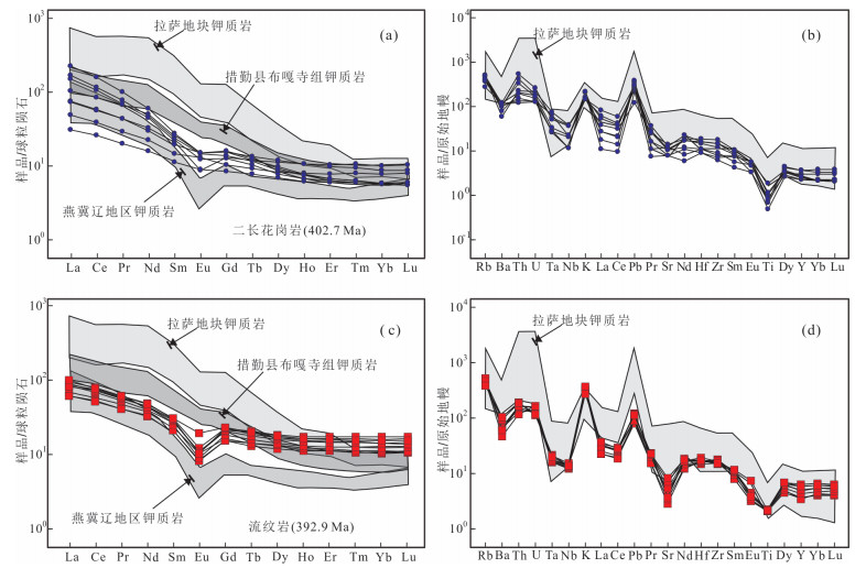
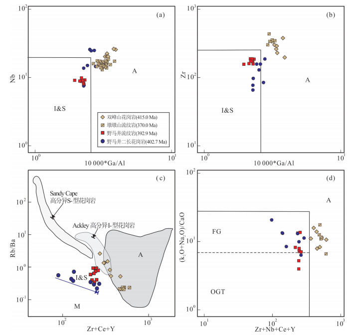
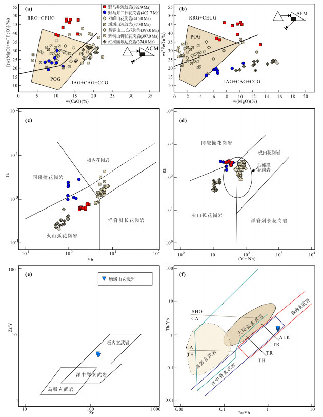
In order to further clarify the tectonic evolution of the southern Beishan orogen during the Late Paleozoic, a comprehensive study including whole rock geochemistry and zircon U-Pb-Hf isotopes has been carried out on the monzonitic granites and rhyolites collected from the Yemajing area. The results of zircon LA-ICP-MS U-Pb dating for the monzonitic granites and rhyolites are 402.7±2.4 Ma and 392.9±2.5 Ma (206Pb/238U ages) respectively, showing these rocks formed during the Devonian. The monzonitic granites and rhyolites in the research area were characterized by potassic, peraluminous to strongly peraluminous, relatively enriched in LREE and depleted in HREE with weak to moderate fractionation between LREE and HREE. The monzonitic granites display no or small negative Eu anomalies, whereas the rhyolites show more obviously negative Eu anomalies. They exhibit similar geochemical compositions including positive Rb, Th, U and Pb, but negative Nb, Ta, Ba, Sr and Ti anomalies, and belong to I-type granites. The zircon εHf(t) values of the monzonitic granites and rhyalites vary from -2.2 to +6, and the Hf model ages (tDM2) vary from 962 Ma to 1533 Ma. Consequently, it can be concluded that the potassic igneous rocks from this area were mainly derived from partial melting of the Middle Proterozoic continental crust. Combining with regional geological evidence, we suggest that the monzonitic granites and rhyolites were probably emplaced or erupted in a post-collision extensional setting. This study provides new crucial evidence for understanding the tectonic evolution of the southern CAOB during the Late Paleozoic.
In order to further clarify the tectonic evolution of the southern Beishan orogen during the Late Paleozoic, a comprehensive study including whole rock geochemistry and zircon U-Pb-Hf isotopes has been carried out on the monzonitic granites and rhyolites collected from the Yemajing area. The results of zircon LA-ICP-MS U-Pb dating for the monzonitic granites and rhyolites are 402.7±2.4 Ma and 392.9±2.5 Ma (206Pb/238U ages) respectively, showing these rocks formed during the Devonian. The monzonitic granites and rhyolites in the research area were characterized by potassic, peraluminous to strongly peraluminous, relatively enriched in LREE and depleted in HREE with weak to moderate fractionation between LREE and HREE. The monzonitic granites display no or small negative Eu anomalies, whereas the rhyolites show more obviously negative Eu anomalies. They exhibit similar geochemical compositions including positive Rb, Th, U and Pb, but negative Nb, Ta, Ba, Sr and Ti anomalies, and belong to I-type granites. The zircon εHf(t) values of the monzonitic granites and rhyalites vary from -2.2 to +6, and the Hf model ages (tDM2) vary from 962 Ma to 1533 Ma. Consequently, it can be concluded that the potassic igneous rocks from this area were mainly derived from partial melting of the Middle Proterozoic continental crust. Combining with regional geological evidence, we suggest that the monzonitic granites and rhyolites were probably emplaced or erupted in a post-collision extensional setting. This study provides new crucial evidence for understanding the tectonic evolution of the southern CAOB during the Late Paleozoic.


2019, 44(8): 2794-2802.
doi: 10.3799/dqkx.2017.547
Abstract:
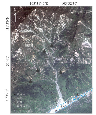
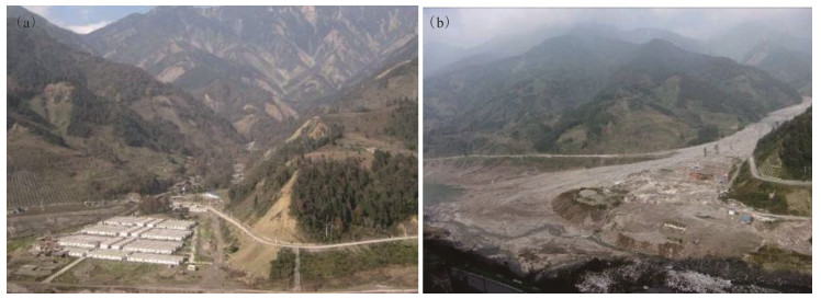
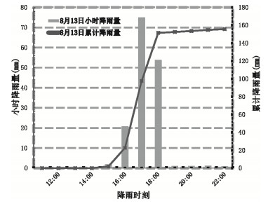
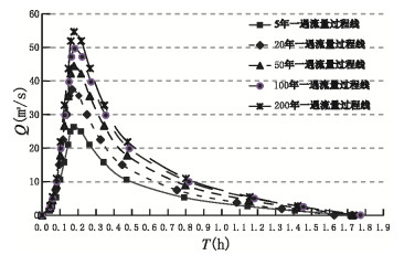
A large number of landslides and rock falls were produced in the meizoseismal area by the "5·12" Wenchuan earthquake. If an extreme rainfall occurred, lots of materials could be transformed into debris flow, with larger size and higher damage degree than expected. On 13th October 2010, debris flow occurred in Bayi gully in Dujiangyan County under rainstorm condition, destroying dam, burying road, houses and farms, and seriously affecting the daily life of local people. In order to reduce these damage, Bayi gully was selected as the research object. Combined debris flow intensity under the different rainfall frequency and period of the outbreak, this paper aims to obtain Bayi gully hazard assessment by the FLO-2D numerical simulation. First, the Bayi gully numerical simulation accuracy can reach 77% according to field test. Then, according to the different frequency of rainfall (5 years, 20 years, 50 years, 100 years, 200 years) and the debris flow velocity and deposit depth, the hazard assessment model is established. Finally, the hazard map of Bayi gully is obtained. The results show that the high hazard area accounted for 62% in the Bayi gully, the medium hazard area accounted for 28%, and the low hazard area accounted for 10%. The hazard assessment of Bayi gully can provide a reliable basis for the post-disaster reconstruction and the key area prevention.
A large number of landslides and rock falls were produced in the meizoseismal area by the "5·12" Wenchuan earthquake. If an extreme rainfall occurred, lots of materials could be transformed into debris flow, with larger size and higher damage degree than expected. On 13th October 2010, debris flow occurred in Bayi gully in Dujiangyan County under rainstorm condition, destroying dam, burying road, houses and farms, and seriously affecting the daily life of local people. In order to reduce these damage, Bayi gully was selected as the research object. Combined debris flow intensity under the different rainfall frequency and period of the outbreak, this paper aims to obtain Bayi gully hazard assessment by the FLO-2D numerical simulation. First, the Bayi gully numerical simulation accuracy can reach 77% according to field test. Then, according to the different frequency of rainfall (5 years, 20 years, 50 years, 100 years, 200 years) and the debris flow velocity and deposit depth, the hazard assessment model is established. Finally, the hazard map of Bayi gully is obtained. The results show that the high hazard area accounted for 62% in the Bayi gully, the medium hazard area accounted for 28%, and the low hazard area accounted for 10%. The hazard assessment of Bayi gully can provide a reliable basis for the post-disaster reconstruction and the key area prevention.


2019, 44(8): 2803-2817.
doi: 10.3799/dqkx.2018.185
Abstract:
AMS 14C dating, clay minerals, major elements and grain size at site U1456 from International Ocean Discovery Program were analyzed, in order to constrain the source-to-sink processes of clay-sized detrital sediments and their paleoenvironmental significance in the eastern Arabian Sea. The clay mineral assemblages at site U1456 since 30 ka are dominated by smectite and illite, with minor chlorite and kaolinite. Provenance analysis results suggest that clay-sized detrital sediments are primarily derived from the Indus River and Deccan Trap. Southwest Asian monsoon probably is the main factor affecting the weathering and erosion in the western Himalaya and the Indian subcontinent since 30 ka. Relatively reduced contribution from the Indus River to the study area during weak southwest Asian monsoon intervals should correlate with the southward migration of the Intertropical Convergence Zone and the extension of glacial cover over the Himalayas during the Last Glacial Maximum, and thus reduction in the Indus River runoff as well as available exposure area for erosion and weathering over the Himalayas. The weathering and erosion on the continent revealed by K/Al ratio show coherent variations to the previous southwest Asian monsoon records, indicating the efficiency of K/Al ratio for tracking the regional climate signal in the eastern Arabian Sea since the late Quaternary.
AMS 14C dating, clay minerals, major elements and grain size at site U1456 from International Ocean Discovery Program were analyzed, in order to constrain the source-to-sink processes of clay-sized detrital sediments and their paleoenvironmental significance in the eastern Arabian Sea. The clay mineral assemblages at site U1456 since 30 ka are dominated by smectite and illite, with minor chlorite and kaolinite. Provenance analysis results suggest that clay-sized detrital sediments are primarily derived from the Indus River and Deccan Trap. Southwest Asian monsoon probably is the main factor affecting the weathering and erosion in the western Himalaya and the Indian subcontinent since 30 ka. Relatively reduced contribution from the Indus River to the study area during weak southwest Asian monsoon intervals should correlate with the southward migration of the Intertropical Convergence Zone and the extension of glacial cover over the Himalayas during the Last Glacial Maximum, and thus reduction in the Indus River runoff as well as available exposure area for erosion and weathering over the Himalayas. The weathering and erosion on the continent revealed by K/Al ratio show coherent variations to the previous southwest Asian monsoon records, indicating the efficiency of K/Al ratio for tracking the regional climate signal in the eastern Arabian Sea since the late Quaternary.


2019, 44(8): 2818-2828.
doi: 10.3799/dqkx.2018.941
Abstract:
In this paper, Mizhi County, a typical example of hill-gully region in the Loess Plateau, was selected as the study area to analyze the water balance and evapotranspiration characteristics of apple forestland. The purpose was to understand correctly and evaluate the eco-hydrological effect of apple forest. A thermal dissipation probe (TDP) and micro-lysimeter were used to measure various components of evapotranspiration such as plant transpiration and soil evaporation, and canopy interception was calculated by water balance formula. This study analyzed the relationship between meteorological factors and transpiration rate, evaluated condition of the evapotranspiration of 7-years apple forest. The results show that the average daily transpiration rate in the different growth periods ranked in the order of fruit growth period > fruit coloring stage > new shoots growth and young fruit growth period > germination and flowering period. The time of peak which the transpiration rate reached at different growth stages was different at the hour scale. Under the different weather conditions, the main meteorological factors affecting the transpiration rate of apple forest were solar radiation and air temperature, and the transpiration in sunny days were significantly larger than that of the rainy days. The main periods of water consumption of apple trees were fruit growth period and fruit coloring period. Precipitation shows significant lagging effect on transpiration. The contribution of plant transpiration, soil evaporation and canopy interception to evapotranspiration in the apple forestland ranked in the order of 58.9% > 26.8% > 14.3%, respectively. During the experiment period, the precipitation was more than the evapotranspiration, and the water of apple forest was surplus. The water management of apple forest should be strengthened in germination and flowering period, new shoots growth and young fruit growth periods.
In this paper, Mizhi County, a typical example of hill-gully region in the Loess Plateau, was selected as the study area to analyze the water balance and evapotranspiration characteristics of apple forestland. The purpose was to understand correctly and evaluate the eco-hydrological effect of apple forest. A thermal dissipation probe (TDP) and micro-lysimeter were used to measure various components of evapotranspiration such as plant transpiration and soil evaporation, and canopy interception was calculated by water balance formula. This study analyzed the relationship between meteorological factors and transpiration rate, evaluated condition of the evapotranspiration of 7-years apple forest. The results show that the average daily transpiration rate in the different growth periods ranked in the order of fruit growth period > fruit coloring stage > new shoots growth and young fruit growth period > germination and flowering period. The time of peak which the transpiration rate reached at different growth stages was different at the hour scale. Under the different weather conditions, the main meteorological factors affecting the transpiration rate of apple forest were solar radiation and air temperature, and the transpiration in sunny days were significantly larger than that of the rainy days. The main periods of water consumption of apple trees were fruit growth period and fruit coloring period. Precipitation shows significant lagging effect on transpiration. The contribution of plant transpiration, soil evaporation and canopy interception to evapotranspiration in the apple forestland ranked in the order of 58.9% > 26.8% > 14.3%, respectively. During the experiment period, the precipitation was more than the evapotranspiration, and the water of apple forest was surplus. The water management of apple forest should be strengthened in germination and flowering period, new shoots growth and young fruit growth periods.


