2019 Vol. 44, No. 9
Display Method:
 PDF 285KB
2019, 44(9): 2829-2838.
doi: 10.3799/dqkx.2019.214
Abstract:
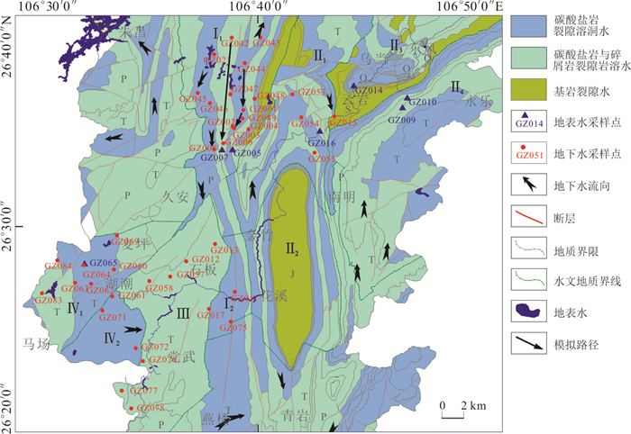
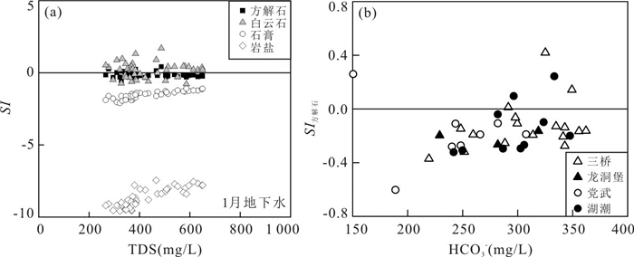
Study on hydrochemical characteristics and water-rock interaction is of great significance to ascertain the causes of groundwater pollution and the sustainable use of karst water. Hydrochemical components and types, ion ratios, strontium content, 87Sr/86Sr ratio and inverse hydrogeochemical modelling were employed to identify hydrochemical evolutional processes of karst groundwater in Guiyang City. The results show that the hydrochemical types of groundwater are mainly HCO3·SO4-Ca and HCO3-Ca·Mg, and the hydrochemical compositions of groundwater varied with time and space due to the dissolution/precipitation of different minerals. The mixing of surface water and groundwater has a certain influence on the hydrochemical characteristics of groundwater. Strontium isotope analysis and inverse hydrogeochemical modeling indicate that the hydrochemical characteristics of groundwater are mainly controlled by rock weathering. The dissolution-precipitation of carbonate dominated by calcite and dolomite as well as the dissolution of sulfate and halite are important processes to control the hydrochemical characteristics of groundwater in the study area, and are also affected by the hydrolysis of silicate minerals in the overlying porous aquifer.
Study on hydrochemical characteristics and water-rock interaction is of great significance to ascertain the causes of groundwater pollution and the sustainable use of karst water. Hydrochemical components and types, ion ratios, strontium content, 87Sr/86Sr ratio and inverse hydrogeochemical modelling were employed to identify hydrochemical evolutional processes of karst groundwater in Guiyang City. The results show that the hydrochemical types of groundwater are mainly HCO3·SO4-Ca and HCO3-Ca·Mg, and the hydrochemical compositions of groundwater varied with time and space due to the dissolution/precipitation of different minerals. The mixing of surface water and groundwater has a certain influence on the hydrochemical characteristics of groundwater. Strontium isotope analysis and inverse hydrogeochemical modeling indicate that the hydrochemical characteristics of groundwater are mainly controlled by rock weathering. The dissolution-precipitation of carbonate dominated by calcite and dolomite as well as the dissolution of sulfate and halite are important processes to control the hydrochemical characteristics of groundwater in the study area, and are also affected by the hydrolysis of silicate minerals in the overlying porous aquifer.


2019, 44(9): 2839-2850.
doi: 10.3799/dqkx.2019.981
Abstract:
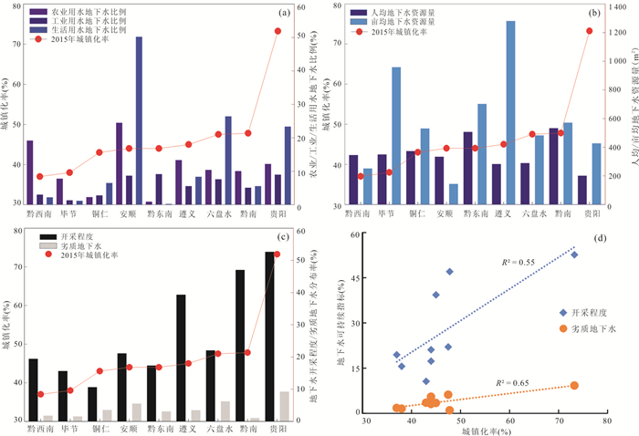
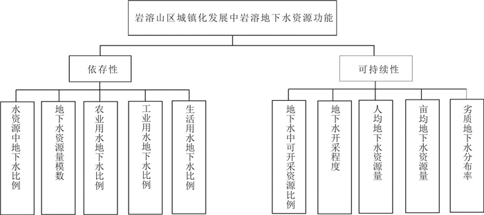
Groundwater resources are basic strategic resources for the development of modern urbanization in karst areas. In order to understand the function of groundwater resources to support urbanization, an index system, Groundwater Resource Function Index, was used to evaluate groundwater's resources function during urbanization in 9 karst zones from Guizhou Province. The research results indicate that groundwater resourcs function varies significantly in response to different urbanization levels. The groundwater resources dependency is higher with stronger resources function in the regions of higher level of urbanization, for example, dependence on groundwater of Guiyang City is as high as 79.08%.Conversely, it is much lower. The sustainability of groundwater resources is impacted by over exploitation and contamination of groundwater, which may result in the weakening even the loss of the resources function of groundwater.
Groundwater resources are basic strategic resources for the development of modern urbanization in karst areas. In order to understand the function of groundwater resources to support urbanization, an index system, Groundwater Resource Function Index, was used to evaluate groundwater's resources function during urbanization in 9 karst zones from Guizhou Province. The research results indicate that groundwater resourcs function varies significantly in response to different urbanization levels. The groundwater resources dependency is higher with stronger resources function in the regions of higher level of urbanization, for example, dependence on groundwater of Guiyang City is as high as 79.08%.Conversely, it is much lower. The sustainability of groundwater resources is impacted by over exploitation and contamination of groundwater, which may result in the weakening even the loss of the resources function of groundwater.


2019, 44(9): 2851-2861.
doi: 10.3799/dqkx.2019.178
Abstract:
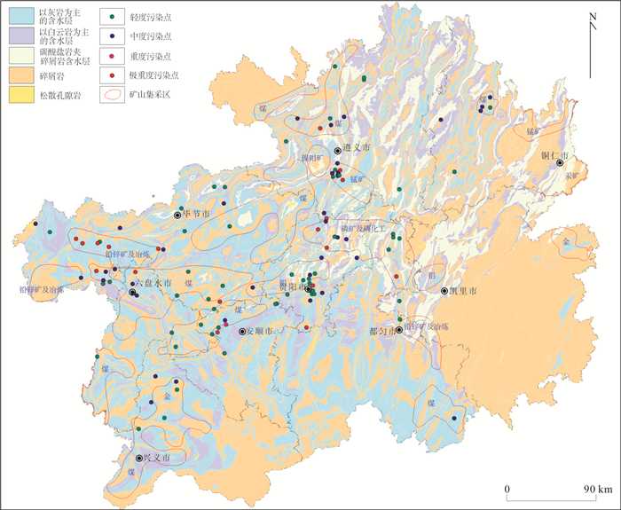
Groundwater environment in karst areas is fragile and vulnerable to human activities and regional environmental changes. There are few studies on combining karst water pollution with stratigraphic lithology and hydrogeological conditions in the area where the pollution point is located. This Paper adopts the improved hierarchical ladder evaluation method to carry out regional groundwater pollution evaluation in Guizhou province, and analyzes the causes of pollution in combination with field investigation. The results show that the Permian Qixia Maokou Formation (22.28%), the Lower Triassic Jialingjiang Formation and Yelang Formation (14.08%), the Middle Triassic Guanling Formation and Yangliujing Formation (13.42%) are carbonate aquifers with the highest degree of pollution in the whole province. The causes are closely related to the rock types and outcropping locations of the aquifers. The types and characteristics of aquifer rocks determine the combination type of water-bearing medium, karst development degree and pollution path pollution distance. The natural pollution prevention capability of limestone formation is mainly medium-long source runoff type, while that of dolomite formation is mainly near source infiltration type. Longtan Formation, a coal-producing formation in Guizhou, is covered by Jialing River Formation and Yelang Formation, and the underlying Qixia Maokou Formation is most vulnerable to coal mining and its chemical industry. The major pollutants are iron, aluminum and manganese. However, the distribution area of Triassic carbonate rocks has a high coincidence with large and medium-sized cities such as Anshun, Guiyang and Zunyi, and industrial, mining and industrial enterprises such as phosphorus chemical industry, aluminum industry and manganese ferroalloy production, which are more susceptible to production and life impacts. Most of the pollutants are ammonia nitrogen, heavy metals, oxygen consumption and organic pollutants.
Groundwater environment in karst areas is fragile and vulnerable to human activities and regional environmental changes. There are few studies on combining karst water pollution with stratigraphic lithology and hydrogeological conditions in the area where the pollution point is located. This Paper adopts the improved hierarchical ladder evaluation method to carry out regional groundwater pollution evaluation in Guizhou province, and analyzes the causes of pollution in combination with field investigation. The results show that the Permian Qixia Maokou Formation (22.28%), the Lower Triassic Jialingjiang Formation and Yelang Formation (14.08%), the Middle Triassic Guanling Formation and Yangliujing Formation (13.42%) are carbonate aquifers with the highest degree of pollution in the whole province. The causes are closely related to the rock types and outcropping locations of the aquifers. The types and characteristics of aquifer rocks determine the combination type of water-bearing medium, karst development degree and pollution path pollution distance. The natural pollution prevention capability of limestone formation is mainly medium-long source runoff type, while that of dolomite formation is mainly near source infiltration type. Longtan Formation, a coal-producing formation in Guizhou, is covered by Jialing River Formation and Yelang Formation, and the underlying Qixia Maokou Formation is most vulnerable to coal mining and its chemical industry. The major pollutants are iron, aluminum and manganese. However, the distribution area of Triassic carbonate rocks has a high coincidence with large and medium-sized cities such as Anshun, Guiyang and Zunyi, and industrial, mining and industrial enterprises such as phosphorus chemical industry, aluminum industry and manganese ferroalloy production, which are more susceptible to production and life impacts. Most of the pollutants are ammonia nitrogen, heavy metals, oxygen consumption and organic pollutants.


2019, 44(9): 2862-2873.
doi: 10.3799/dqkx.2019.150
Abstract:
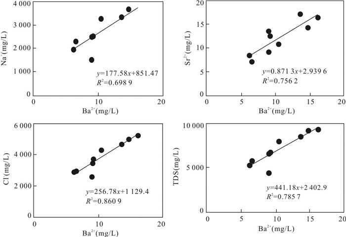
Coal seams are often enriched in various toxic and harmful elements such as F, As, Cd, Cr, Ni, Pb, Hg and Sb, so the ecosystem might be faced with serious environmental threats when the co-produced water is brought to the surface in the production of coalbed methane (CBM). In this paper, we present a systematic water chemistry study of co-produced water from Songhe coalbed methane development block in western Guizhou Province. The results show that, compared to Class Ⅲ of Groundwater Quality Standard (GB/T 14848-2017), Ba and Hg in co-produced water in the study area exceeded the standard seriously, and the average concentrations were 10 621.6 μg/L and 16.5 μg/L, respectively. The Ba anomaly in co-produced water was attributed to the dissolution of Ba-bearing carbonates and the depletion of sulfate induced by sulfate reduction, and Hg was from sulfide minerals. The sources for Cr, Mo, Cd and Sb were sulfides and carbonates in coal seams. The high content of Mo is associated with ion exchange reactions under high salinity, and molybdate and metallic sulfides are the main forms for Mo. Under weak alkaline conditions, the hydroxide adsorption state of Al is the main occurrence form of Cr, Mo, Mn, Cd, Sb, Cd, Cu, Pb and Ba in the co-produced water. The sources of Ni were obviously different from those of other elements, and it most likely came from the mineralization of coal organic matters. The results of water quality evaluation showed that the pollution of the water coproduced from coalbed methane wells in the study area is very serious, which is mainly due to the serious overstandard of Hg and Ba. In SH9, mercury is 27 times the legal limits and that is 23 times for barium in SH8.
Coal seams are often enriched in various toxic and harmful elements such as F, As, Cd, Cr, Ni, Pb, Hg and Sb, so the ecosystem might be faced with serious environmental threats when the co-produced water is brought to the surface in the production of coalbed methane (CBM). In this paper, we present a systematic water chemistry study of co-produced water from Songhe coalbed methane development block in western Guizhou Province. The results show that, compared to Class Ⅲ of Groundwater Quality Standard (GB/T 14848-2017), Ba and Hg in co-produced water in the study area exceeded the standard seriously, and the average concentrations were 10 621.6 μg/L and 16.5 μg/L, respectively. The Ba anomaly in co-produced water was attributed to the dissolution of Ba-bearing carbonates and the depletion of sulfate induced by sulfate reduction, and Hg was from sulfide minerals. The sources for Cr, Mo, Cd and Sb were sulfides and carbonates in coal seams. The high content of Mo is associated with ion exchange reactions under high salinity, and molybdate and metallic sulfides are the main forms for Mo. Under weak alkaline conditions, the hydroxide adsorption state of Al is the main occurrence form of Cr, Mo, Mn, Cd, Sb, Cd, Cu, Pb and Ba in the co-produced water. The sources of Ni were obviously different from those of other elements, and it most likely came from the mineralization of coal organic matters. The results of water quality evaluation showed that the pollution of the water coproduced from coalbed methane wells in the study area is very serious, which is mainly due to the serious overstandard of Hg and Ba. In SH9, mercury is 27 times the legal limits and that is 23 times for barium in SH8.


2019, 44(9): 2874-2886.
doi: 10.3799/dqkx.2019.146
Abstract:
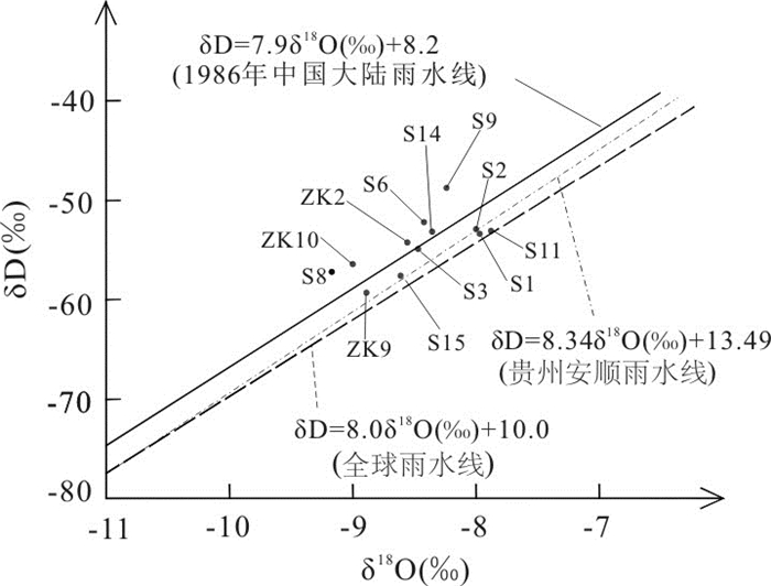
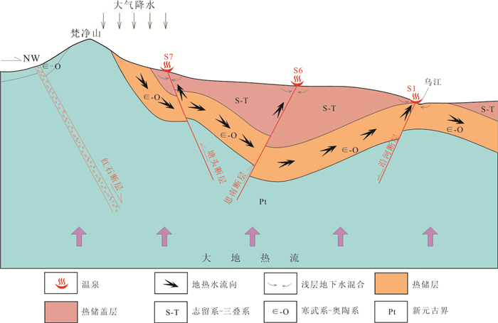
The hydrochemical characteristics of geothermal water and the source of geothermal water have not been systematically carried out in the northeastern Guizhou, and there are problems such as unclear geothermal water sources, recharge areas, runoff and excretion. On the basis of fully understanding the geothermal geological conditions in the northeastern Guizhou, 15 groups of geothermal water in the collection area for water chemistry were analyzed, 12 groups of geothermal water hydrogen and oxygen isotopes and 3 pieces of geothermal water carbon isotope data were collected in this study, aimed to firstly obtain the water chemical characteristics and isotopic characteristics of geothermal water in this area, secondly to find the source of geothermal water and thirdly to estimate the recharge elevation, recharge temperature, heat storage temperature, circulation depth, and cold water mixing ratio of geothermal water. The results show that the geothermal water in this area mainly runs from south to north due to the topography and geological structure. The hydrochemical types of geothermal water are mainly HCO3·SO4-Ca·Mg, HCO3-Ca·Mg, HCO3-Na, SO4-Ca·Mg and SO4-Ca types, the beneficial elements are mainly F- and H2SiO3, the geothermal water in the direction of runoff shows a decrease in pH and an increase in TDS, the type of water chemistry changes from bicarbonate to sulfuric acid salt-type water. The results of isotope analysis indicate that the geothermal water supply source in this area is atmospheric precipitation, and the recharge area is Fanjing Mountain area with an altitude of 1 500-2 000 m. The geothermal water age is (6 400-11 570) ±560 a, and the annual average temperature during recharge is 7.0-9.1℃. Using silica temperature scale and lg (Q/K)-T method, the heat storage temperature is estimated at 45.0-107.0℃, and geothermal water circulation depth of 1 000-3 000 m. By silicon-helium mixed model, the heat storage is estimated before the mixing of geothermal water, showing the maximum temperature at 110-200℃.The geothermal water is mixed by the shallow cold water during the ascending process, and the proportion of cold water mixed is 50% to 90%.
The hydrochemical characteristics of geothermal water and the source of geothermal water have not been systematically carried out in the northeastern Guizhou, and there are problems such as unclear geothermal water sources, recharge areas, runoff and excretion. On the basis of fully understanding the geothermal geological conditions in the northeastern Guizhou, 15 groups of geothermal water in the collection area for water chemistry were analyzed, 12 groups of geothermal water hydrogen and oxygen isotopes and 3 pieces of geothermal water carbon isotope data were collected in this study, aimed to firstly obtain the water chemical characteristics and isotopic characteristics of geothermal water in this area, secondly to find the source of geothermal water and thirdly to estimate the recharge elevation, recharge temperature, heat storage temperature, circulation depth, and cold water mixing ratio of geothermal water. The results show that the geothermal water in this area mainly runs from south to north due to the topography and geological structure. The hydrochemical types of geothermal water are mainly HCO3·SO4-Ca·Mg, HCO3-Ca·Mg, HCO3-Na, SO4-Ca·Mg and SO4-Ca types, the beneficial elements are mainly F- and H2SiO3, the geothermal water in the direction of runoff shows a decrease in pH and an increase in TDS, the type of water chemistry changes from bicarbonate to sulfuric acid salt-type water. The results of isotope analysis indicate that the geothermal water supply source in this area is atmospheric precipitation, and the recharge area is Fanjing Mountain area with an altitude of 1 500-2 000 m. The geothermal water age is (6 400-11 570) ±560 a, and the annual average temperature during recharge is 7.0-9.1℃. Using silica temperature scale and lg (Q/K)-T method, the heat storage temperature is estimated at 45.0-107.0℃, and geothermal water circulation depth of 1 000-3 000 m. By silicon-helium mixed model, the heat storage is estimated before the mixing of geothermal water, showing the maximum temperature at 110-200℃.The geothermal water is mixed by the shallow cold water during the ascending process, and the proportion of cold water mixed is 50% to 90%.


2019, 44(9): 2887-2898.
doi: 10.3799/dqkx.2019.201
Abstract:
The surface water and groundwater which are critical resources for daily life, industrial and agricultural production exchange frequently in Liupanshui mining area.To ensure the security and sustainability of water system in the karst critical zone, thirty-three water samples were collected from the typical Liupanshui mining area in September 2015. They were analyzed by using the methods of hydrochemistry, correlation analysis and ion ratios. The results show most groundwater hydrochemical type was CaHCO3 type, and some was Ca-SO4 type. Most surface water was Ca-HCO3 type and Ca-SO4 type. Differently, the mine waste water was Na-HCO3 type and the acid mine waste water was Ca-SO4 type. There was a significant positive correlation between Ca2+, Mg2+ and HCO3- which was mainly controlled by reaction between water and carbonate, and some Na+ and K+ were controlled by reaction between water and silicate. The sources of Cl- were mainly sewage, most of NO3- were affected by agricultural production, and SO42- came from multiple sources. Mining activities, urbanization and agricultural production have affected the compositions of water ions, in addition mining activities have accelerated the dissolution of carbonate. These three factors have made significant changes in the hydrochemistry types. Under these compound influences affected by human activities, mining activities are the key driving factors for the changes of hydrochemical characteristics in water system of the karst critical zone.
The surface water and groundwater which are critical resources for daily life, industrial and agricultural production exchange frequently in Liupanshui mining area.To ensure the security and sustainability of water system in the karst critical zone, thirty-three water samples were collected from the typical Liupanshui mining area in September 2015. They were analyzed by using the methods of hydrochemistry, correlation analysis and ion ratios. The results show most groundwater hydrochemical type was CaHCO3 type, and some was Ca-SO4 type. Most surface water was Ca-HCO3 type and Ca-SO4 type. Differently, the mine waste water was Na-HCO3 type and the acid mine waste water was Ca-SO4 type. There was a significant positive correlation between Ca2+, Mg2+ and HCO3- which was mainly controlled by reaction between water and carbonate, and some Na+ and K+ were controlled by reaction between water and silicate. The sources of Cl- were mainly sewage, most of NO3- were affected by agricultural production, and SO42- came from multiple sources. Mining activities, urbanization and agricultural production have affected the compositions of water ions, in addition mining activities have accelerated the dissolution of carbonate. These three factors have made significant changes in the hydrochemistry types. Under these compound influences affected by human activities, mining activities are the key driving factors for the changes of hydrochemical characteristics in water system of the karst critical zone.


2019, 44(9): 2899-2908.
doi: 10.3799/dqkx.2019.170
Abstract:
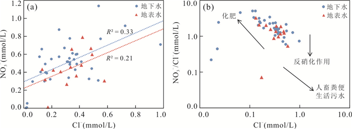
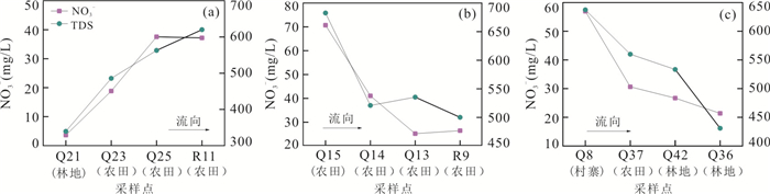
The water environment of karst catchment is very susceptible to human activities. Nitrate pollution is a prominent and common problem in karst catchment. It is important to clarify the source, distribution characteristics and formation mechanism of nitrate in waters of karst catchment, which can facilitate the nitrate pollution prevention in karst catchment. The Houzhai River catchment of Puding of Guizhou was selected as the study area. 53 samples of groundwater and surface water were collected for measuring water chemical parameters in May 2017. Water chemical parameters were determined for analyzing the NO3- source. Combined with the land use type, the influence of the nitrate spatial distribution was discussed along the flow path. The results show that the order of ion concentration in waters was Ca2+ > Mg2+ > Na+ > K+, HCO3- > SO42- > NO3- > Cl- in the study area, respectively. The type of water chemistry was HCO3-Ca. The main source of NO3- was the chemical fertilizer. Variations of NO3- concentration along the flow path were mainly controlled by the mixing process, and the impact of nitrification and denitrification was not obvious. Waters of 6 sampling sites were obviously polluted by nitrate. The concentration of NO3- in waters of the catchment was obviously affected by the land use pattern. NO3- concentration increased when waters flowed through farmland or villages, and decreased when they flowed through forest land.
The water environment of karst catchment is very susceptible to human activities. Nitrate pollution is a prominent and common problem in karst catchment. It is important to clarify the source, distribution characteristics and formation mechanism of nitrate in waters of karst catchment, which can facilitate the nitrate pollution prevention in karst catchment. The Houzhai River catchment of Puding of Guizhou was selected as the study area. 53 samples of groundwater and surface water were collected for measuring water chemical parameters in May 2017. Water chemical parameters were determined for analyzing the NO3- source. Combined with the land use type, the influence of the nitrate spatial distribution was discussed along the flow path. The results show that the order of ion concentration in waters was Ca2+ > Mg2+ > Na+ > K+, HCO3- > SO42- > NO3- > Cl- in the study area, respectively. The type of water chemistry was HCO3-Ca. The main source of NO3- was the chemical fertilizer. Variations of NO3- concentration along the flow path were mainly controlled by the mixing process, and the impact of nitrification and denitrification was not obvious. Waters of 6 sampling sites were obviously polluted by nitrate. The concentration of NO3- in waters of the catchment was obviously affected by the land use pattern. NO3- concentration increased when waters flowed through farmland or villages, and decreased when they flowed through forest land.


2019, 44(9): 2909-2919.
doi: 10.3799/dqkx.2019.135
Abstract:
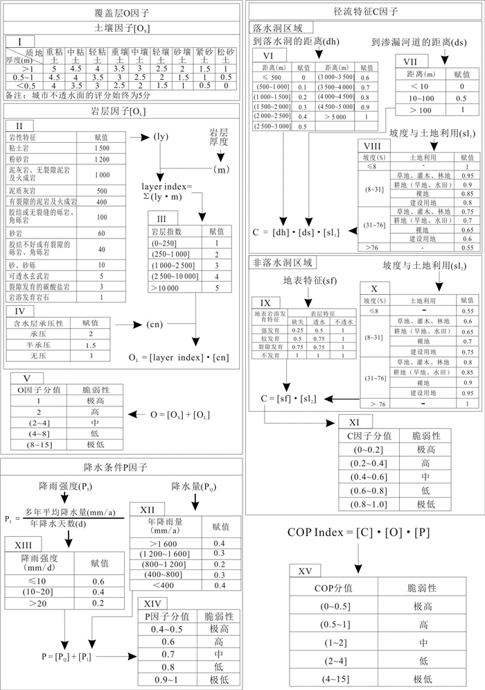
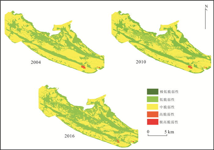
Karst groundwater is an important water supply source for Liupanshui City of Guizhou Province. However, vulnerability assessment of karst groundwater in this region, especially in the urbanized areas has not been reported. To characterize urbanization factors of groundwater vulnerability assessment in karst area, we chose Shuicheng Basin as the study area, used and improved the Concentration of Flow-Overlying Layers-Precipitation (COP) model, and processed data of soil types, land use/land cover, and precipitation by RS and GIS technologies. Results show that the inherent vulnerability of groundwater for the study area decreased from medium to low during 2004 to 2016, and the area with decreased vulnerability is consistent with the increased impervious area caused by urbanization. It suggests that impervious grounds hinder inputs of surface pollutants, reducing inherent vulnerability of groundwater. Our results are important for karst water resource management in the study area.
Karst groundwater is an important water supply source for Liupanshui City of Guizhou Province. However, vulnerability assessment of karst groundwater in this region, especially in the urbanized areas has not been reported. To characterize urbanization factors of groundwater vulnerability assessment in karst area, we chose Shuicheng Basin as the study area, used and improved the Concentration of Flow-Overlying Layers-Precipitation (COP) model, and processed data of soil types, land use/land cover, and precipitation by RS and GIS technologies. Results show that the inherent vulnerability of groundwater for the study area decreased from medium to low during 2004 to 2016, and the area with decreased vulnerability is consistent with the increased impervious area caused by urbanization. It suggests that impervious grounds hinder inputs of surface pollutants, reducing inherent vulnerability of groundwater. Our results are important for karst water resource management in the study area.


2019, 44(9): 2920-2930.
doi: 10.3799/dqkx.2019.184
Abstract:
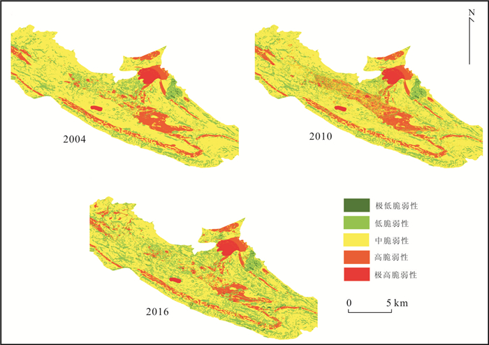
In order to evaluate the pollution risk of deep pollution sources on upper aquifer during shale gas exploitation, the deep vulnerability assessment index system of groundwater was built up by analytic hierarchy process from three aspects:natural protection, impact route and driving force, based on the "source-pathway-drive-receptor" conceptual model. In addition, groundwater deep vulnerability assessment of shale gas mining block in Guizhou Province was assessed as an example. The results show the deep groundwater vulnerability rank mainly is low and medium-low in the study area, accounting for 69.15% of the total area, which is distributed in the northwest, central and southeast of the study area. The thickness of the intermediate layer is the main indicator affecting the evaluation. The evaluation system can be applied to the groundwater deep vulnerability assessment of shale gas exploitation area, enriching the existing groundwater vulnerability assessment system, and providing technical support for shale gas well layout and groundwater environmental protection.
In order to evaluate the pollution risk of deep pollution sources on upper aquifer during shale gas exploitation, the deep vulnerability assessment index system of groundwater was built up by analytic hierarchy process from three aspects:natural protection, impact route and driving force, based on the "source-pathway-drive-receptor" conceptual model. In addition, groundwater deep vulnerability assessment of shale gas mining block in Guizhou Province was assessed as an example. The results show the deep groundwater vulnerability rank mainly is low and medium-low in the study area, accounting for 69.15% of the total area, which is distributed in the northwest, central and southeast of the study area. The thickness of the intermediate layer is the main indicator affecting the evaluation. The evaluation system can be applied to the groundwater deep vulnerability assessment of shale gas exploitation area, enriching the existing groundwater vulnerability assessment system, and providing technical support for shale gas well layout and groundwater environmental protection.


2019, 44(9): 2931-2943.
doi: 10.3799/dqkx.2019.213
Abstract:
Influenced by the development of surface fractures and the characteristics of rocky desertification, the cycle transformation mechanism between slope runoff and runoff components is complex in the karst area in Southwest China, which leads to the strong spatial heterogeneity of slope runoff efficiency and becomes one of the difficulties in karst hydrology. Previous studies on many karst regions are usually based on hydrological models and technologies for non-karst areas, which focus on slope runoff yield affecting factors, the generalized process of slope runoff, the efficient utilization of water resources, slope runoff models and slope surface water resources development. However, their analyses are not comprehensive even though they can enhance the use efficiency of slope runoff, since the earth-rock interface and the interaction of underground runoff and soil have been neglected in the study of runoff process of filling up runoff and the permeability and the influence of slope runoff process. Therefore, on the basis of summarizing the influencing factors of runoff and runoff on karst slope, this paper firstly puts forward the process framework of runoff and runoff on karst slope. Then combined with slope surface flow analysis method and the development and utilization of technology model, existing slope technology of efficient utilization of water resources value and the existing limitations are evaluated. Finally the process of slope runoff is simulated from time and space differences of slope runoff process and the future development trend of the slope surface water resources utilization technology is prospected.
Influenced by the development of surface fractures and the characteristics of rocky desertification, the cycle transformation mechanism between slope runoff and runoff components is complex in the karst area in Southwest China, which leads to the strong spatial heterogeneity of slope runoff efficiency and becomes one of the difficulties in karst hydrology. Previous studies on many karst regions are usually based on hydrological models and technologies for non-karst areas, which focus on slope runoff yield affecting factors, the generalized process of slope runoff, the efficient utilization of water resources, slope runoff models and slope surface water resources development. However, their analyses are not comprehensive even though they can enhance the use efficiency of slope runoff, since the earth-rock interface and the interaction of underground runoff and soil have been neglected in the study of runoff process of filling up runoff and the permeability and the influence of slope runoff process. Therefore, on the basis of summarizing the influencing factors of runoff and runoff on karst slope, this paper firstly puts forward the process framework of runoff and runoff on karst slope. Then combined with slope surface flow analysis method and the development and utilization of technology model, existing slope technology of efficient utilization of water resources value and the existing limitations are evaluated. Finally the process of slope runoff is simulated from time and space differences of slope runoff process and the future development trend of the slope surface water resources utilization technology is prospected.


2019, 44(9): 2944-2954.
doi: 10.3799/dqkx.2019.216
Abstract:
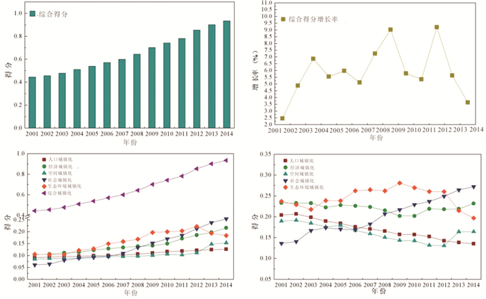
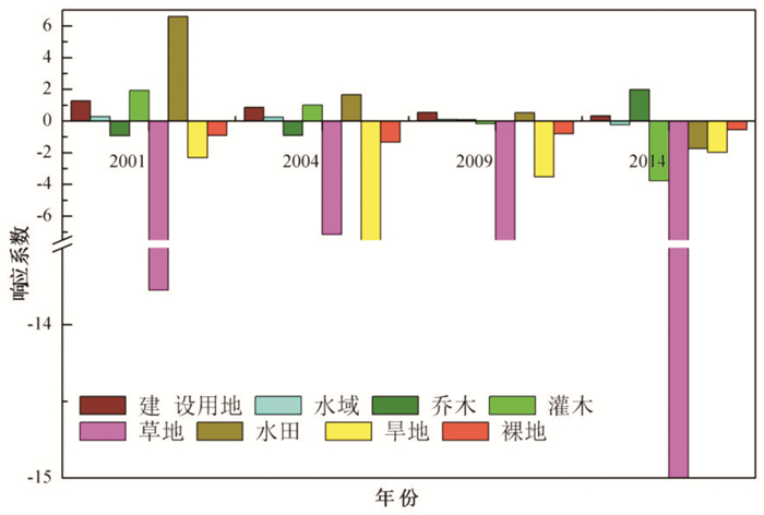
The karst landforms are widely developed in Guiyang and available land resources are limited, which leads to the constrains between urbanization development and land use. This study addresses the relationship between urbanization and land use. Based on the urbanization index data of Guiyang City from 2001 to 2014 and the remote sensing image data of 1996, 2001, 2004, 2009 and 2016, the index weight method and land use type transfer matrix were used to analyze the development trend of urbanization in Guiyang from 2001 to 2014. And the spatial and temporal distribution characteristics and evolution of land use in 1996-2016. And the correlation analysis method is used to establish the function responsivity model, and the relationship between urbanization and land use is discussed. The results show that:(1) In the period of 2001-2014, the urbanization level of Guiyang City showed an upward trend, and the comprehensive urbanization score growth rate was 52.46%. Among them, the population (26.0%), ecology (20.4%), space (19.9%) and economy (18.3%) urbanization contributed a lot to the comprehensive urbanization, and the socialization (15.4%) was relatively small. (2) The increase of agricultural land and construction land in Guiyang City, the total net growth was 23.66%, the reduction of unused land area, the total net reduction was 23.56%, and the total change in land use type was 87.77%. (3) The urbanization process promotes the change of land use. In 2001-2014, the comprehensive response of land use types to urbanization is higher in paddy fields (13.767), bare land (4.476), dry land (1.708) and shrubs (1.319). Trees (0.897), grassland (0.878), construction land (0.693), and waters (0.180) are relatively low. The rapid expansion of urban land use is a direct factor in the transformation of land use types. Therefore, it is recommended to optimize the land use structure in the process of urbanization to improve the efficiency of land use and ensure the sustainable development of urbanization.
The karst landforms are widely developed in Guiyang and available land resources are limited, which leads to the constrains between urbanization development and land use. This study addresses the relationship between urbanization and land use. Based on the urbanization index data of Guiyang City from 2001 to 2014 and the remote sensing image data of 1996, 2001, 2004, 2009 and 2016, the index weight method and land use type transfer matrix were used to analyze the development trend of urbanization in Guiyang from 2001 to 2014. And the spatial and temporal distribution characteristics and evolution of land use in 1996-2016. And the correlation analysis method is used to establish the function responsivity model, and the relationship between urbanization and land use is discussed. The results show that:(1) In the period of 2001-2014, the urbanization level of Guiyang City showed an upward trend, and the comprehensive urbanization score growth rate was 52.46%. Among them, the population (26.0%), ecology (20.4%), space (19.9%) and economy (18.3%) urbanization contributed a lot to the comprehensive urbanization, and the socialization (15.4%) was relatively small. (2) The increase of agricultural land and construction land in Guiyang City, the total net growth was 23.66%, the reduction of unused land area, the total net reduction was 23.56%, and the total change in land use type was 87.77%. (3) The urbanization process promotes the change of land use. In 2001-2014, the comprehensive response of land use types to urbanization is higher in paddy fields (13.767), bare land (4.476), dry land (1.708) and shrubs (1.319). Trees (0.897), grassland (0.878), construction land (0.693), and waters (0.180) are relatively low. The rapid expansion of urban land use is a direct factor in the transformation of land use types. Therefore, it is recommended to optimize the land use structure in the process of urbanization to improve the efficiency of land use and ensure the sustainable development of urbanization.

2019, 44(9): 2955-2962.
doi: 10.3799/dqkx.2019.153
Abstract:
The results of different filtering methods for inversing changes in terrestrial water reserves are different, but there are relatively few comparative studies between different filtering methods for the southwestern karst area. This paper uses four filtering methods, namely Gauss 200 km, Fan 200 km, Han 200 km and DDK4 on the inversion of terrestrial water storage in the southwestern karst area, and uses scale factors to correct. In spatial distribution, Han and Fan filters are smoother than Gauss filters, but the loss of real signals is more, and Han filter loss is the most serious. DDK filtering can maintain the magnitude and shape of the original signal while performing north-south filtering. In the time series, the four filtered Terrestrial Water Storage Anomalies (TWSA) annual trends are 8.64, 8.77, 9.05 and 9.39, respectively. The annual amplitudes are 82.30, 87.47, 107.70 and 78.51. The spatial distribution of terrestrial water reserves inversion by different filters is quite different. The annual phase of the four filters is not much different, and due to the influence of scale factors, the order of corrected anomalous amplitude of terrestrial water storageis:Han > Fan > Gauss > DDK. For the inversion of terrestrial water storage change in the study area, Fan filtering and DDK filtering are better.
The results of different filtering methods for inversing changes in terrestrial water reserves are different, but there are relatively few comparative studies between different filtering methods for the southwestern karst area. This paper uses four filtering methods, namely Gauss 200 km, Fan 200 km, Han 200 km and DDK4 on the inversion of terrestrial water storage in the southwestern karst area, and uses scale factors to correct. In spatial distribution, Han and Fan filters are smoother than Gauss filters, but the loss of real signals is more, and Han filter loss is the most serious. DDK filtering can maintain the magnitude and shape of the original signal while performing north-south filtering. In the time series, the four filtered Terrestrial Water Storage Anomalies (TWSA) annual trends are 8.64, 8.77, 9.05 and 9.39, respectively. The annual amplitudes are 82.30, 87.47, 107.70 and 78.51. The spatial distribution of terrestrial water reserves inversion by different filters is quite different. The annual phase of the four filters is not much different, and due to the influence of scale factors, the order of corrected anomalous amplitude of terrestrial water storageis:Han > Fan > Gauss > DDK. For the inversion of terrestrial water storage change in the study area, Fan filtering and DDK filtering are better.


2019, 44(9): 2963-2977.
doi: 10.3799/dqkx.2018.255
Abstract:
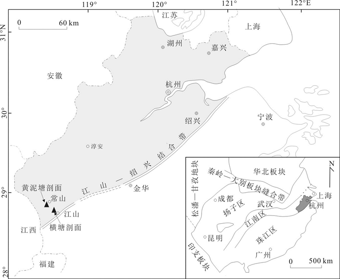
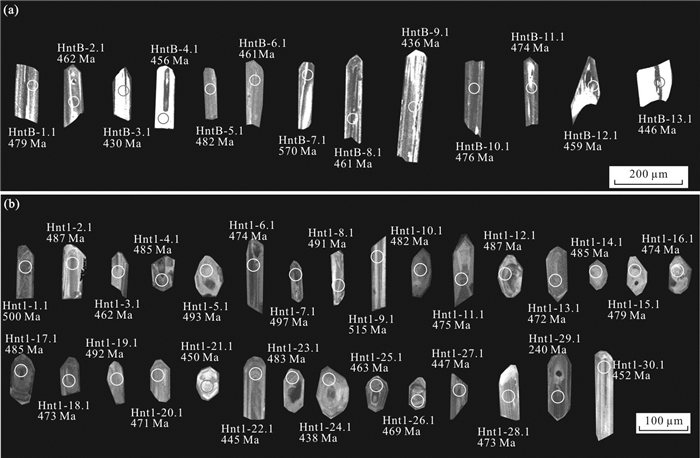
There are no exact isotopic age data for "Golden Spike" in Jiangshan-Changshan-Yushan, Zhejiang-Jiangxi border area. The analysis of SHRIMP U-Pb zircons from the Ningkuo Formation K-bentonites in Jiangshan-Changshan-Yushan, yielded the age of middle Azygograptus suecicus Zone as 482.9±6.1 Ma, bottom Exigraptus clavus Zone as 477.6±8.3 Ma, and the middle Acrograptus ellesae Zone as 467.0±4.4 Ma, which provides the basis for exact correlation from the GSSP of Dapingian and Darriwilian strata in South China to other areas. Combined with contrast of biozones, the general strata-lost events occurred from 482.9 Ma to 477.6 Ma in West Zhejiang, which equated to the lacuna of the Oepikodus evae Zone to the Lenodus anticariabilis Zone, or Azygograptus suecicus Zone to Acrograptus ellesae Zone in Hangzhou-Jiaxing platform. We consider that it embodied the Yunan Movement in West Zhejiang, and heralded the start of the Early Paleozoic tectonic movement in South China, while responding to the Humberian Movement and Tactonic Movement in the European Caledonian Orogeny.
There are no exact isotopic age data for "Golden Spike" in Jiangshan-Changshan-Yushan, Zhejiang-Jiangxi border area. The analysis of SHRIMP U-Pb zircons from the Ningkuo Formation K-bentonites in Jiangshan-Changshan-Yushan, yielded the age of middle Azygograptus suecicus Zone as 482.9±6.1 Ma, bottom Exigraptus clavus Zone as 477.6±8.3 Ma, and the middle Acrograptus ellesae Zone as 467.0±4.4 Ma, which provides the basis for exact correlation from the GSSP of Dapingian and Darriwilian strata in South China to other areas. Combined with contrast of biozones, the general strata-lost events occurred from 482.9 Ma to 477.6 Ma in West Zhejiang, which equated to the lacuna of the Oepikodus evae Zone to the Lenodus anticariabilis Zone, or Azygograptus suecicus Zone to Acrograptus ellesae Zone in Hangzhou-Jiaxing platform. We consider that it embodied the Yunan Movement in West Zhejiang, and heralded the start of the Early Paleozoic tectonic movement in South China, while responding to the Humberian Movement and Tactonic Movement in the European Caledonian Orogeny.


2019, 44(9): 2978-2994.
doi: 10.3799/dqkx.2019.019
Abstract:
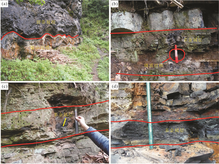
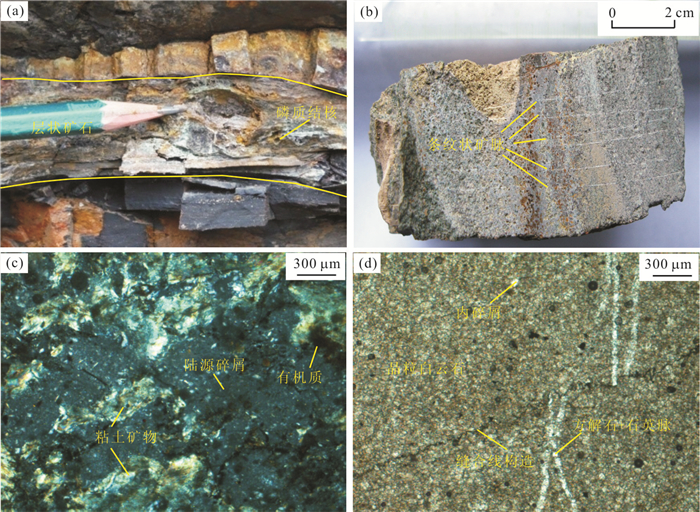
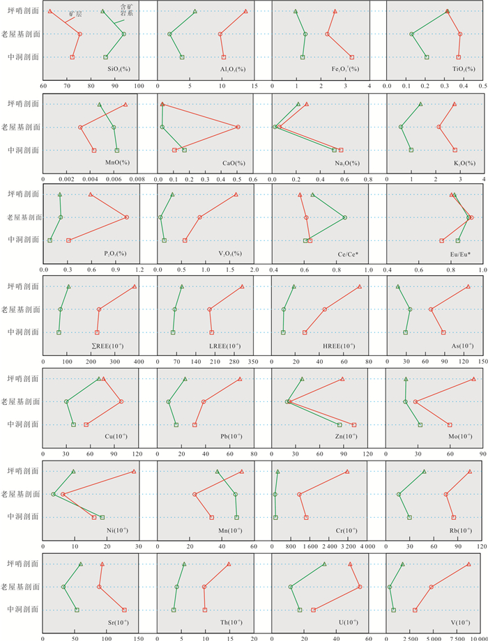
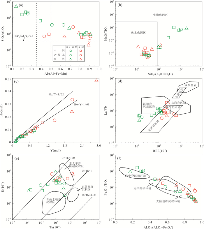
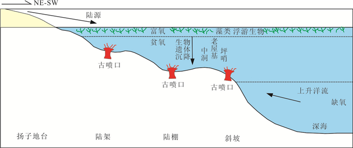
There is an urgent need to analyze the forming environment,the metal enrichment process and ore-forming rules of the Zhuxi vanadium ore field in eastern Guizhou Province. This paper systematically studies the major and trace element compositions of ore-bearing rocks and ore strata from three typical black shale sections in the ore field. The results show that ore-bearing rocks contain high contents/values of SiO2,MnO,Ce/Ce* and Eu/Eu*,while ore strata have higher concentrations of Al2O3,Fe2O3,TiO2,CaO,Na2O,K2O,P2O5,V2O5,REE,As,Cu,Pb,Zn,Mo,Ni,Ti,Cr,Rb,Sr,Th,U and V. The major and trace element geochemical characteristics of ore-bearing rocks and ores indicate that the ore-forming source of the Zhuxi vanadium ore field had a certain degree of continental material input,whilst both hydrothermal and biological processes played a significant role during the ore-forming process. In addition,the intensities of hydrothermal process decreased from southern to northern sections and the sedimentary environment of both ore-bearing rocks and ores was anoxic. The ores from the Pingshao lithological sections were formed in the most reducing environment than those from other sections. Therefore,the V enrichment and mineralization in the Zhuxi ore field has mainly been controlled by reducing paleoenvironment and hydrothermal activity,and the reducing environment has been more significant for V mineralization. It can be inferred that ores from the Pingshao section should have been deposited in the deepest seawater environment while the ores from northern Zhongdong section had the shallowest seawater level. Exhalative fluid brought abundant V and other metal elements depositing in the vent and adjacent areas,leading to the large-scale mineralization.
There is an urgent need to analyze the forming environment,the metal enrichment process and ore-forming rules of the Zhuxi vanadium ore field in eastern Guizhou Province. This paper systematically studies the major and trace element compositions of ore-bearing rocks and ore strata from three typical black shale sections in the ore field. The results show that ore-bearing rocks contain high contents/values of SiO2,MnO,Ce/Ce* and Eu/Eu*,while ore strata have higher concentrations of Al2O3,Fe2O3,TiO2,CaO,Na2O,K2O,P2O5,V2O5,REE,As,Cu,Pb,Zn,Mo,Ni,Ti,Cr,Rb,Sr,Th,U and V. The major and trace element geochemical characteristics of ore-bearing rocks and ores indicate that the ore-forming source of the Zhuxi vanadium ore field had a certain degree of continental material input,whilst both hydrothermal and biological processes played a significant role during the ore-forming process. In addition,the intensities of hydrothermal process decreased from southern to northern sections and the sedimentary environment of both ore-bearing rocks and ores was anoxic. The ores from the Pingshao lithological sections were formed in the most reducing environment than those from other sections. Therefore,the V enrichment and mineralization in the Zhuxi ore field has mainly been controlled by reducing paleoenvironment and hydrothermal activity,and the reducing environment has been more significant for V mineralization. It can be inferred that ores from the Pingshao section should have been deposited in the deepest seawater environment while the ores from northern Zhongdong section had the shallowest seawater level. Exhalative fluid brought abundant V and other metal elements depositing in the vent and adjacent areas,leading to the large-scale mineralization.


2019, 44(9): 2995-3006.
doi: 10.3799/dqkx.2018.193
Abstract:
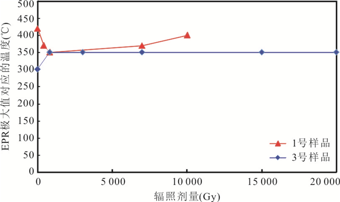
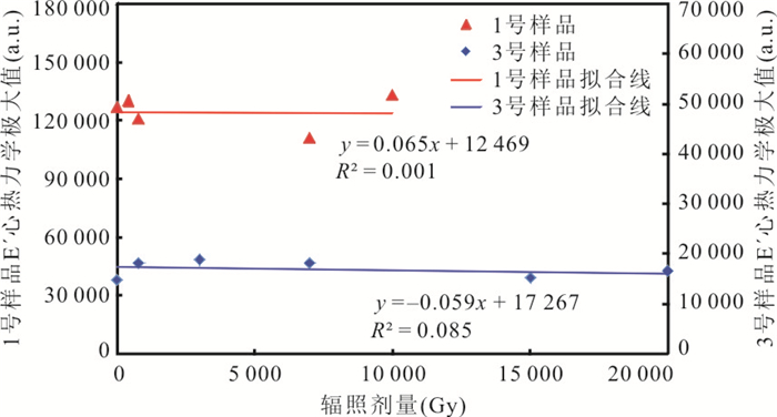
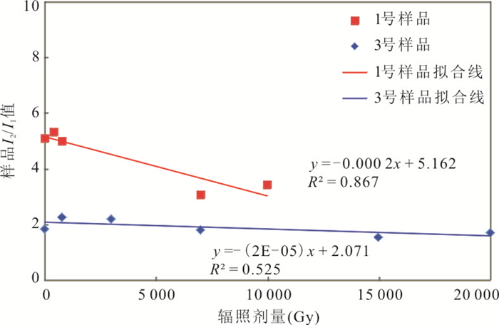
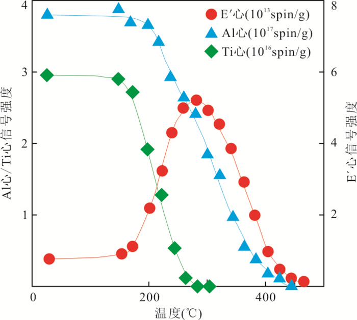
The electron paramagnetic resonance of quartz is a dating technique through accumulated irradiation energy absorbed by minerals. Although it is commonly used in Quaternary period,the greatly enhanced EPR signals of quartz E' center after thermal activation provide opportunity for extending the dating range of EPR,while there are many different opinions on the thermal activation physical conditions and the formation and transformation mechanism of quartz E' center. In this paper,through the artificial γ ray radiation and stepwise annealing experiments to the granite and fault zone samples,the quartz E' center signal intensities under different irradiation conditions and different temperatures are measured by EPR technique,and the growth and formation mechanisms of quartz E' center are studied. The results indicate that the signal intensity of quartz E' center can be enhanced by normal artificial γ ray radiation under room temperature and by high temperature heating. The dating method and geological significance of E' center at normal and high temperature is discussed separately. The signal intensity of normal E' center is relatively constant below 150℃,and can be calibrated to calculate the accumulated dose and date fault forming age within Quaternary by normal additive dose method. The signal intensity of quartz E' center can be greatly enhanced by thermal activation and can be used to date geological age before Quaternary,but the activated peak signal intensity of known age quartz E' center should be used as a benchmark or the oxygen vacancy should be regenerated by high-dose γ ray irradiation or neutron irradiation. Then,the dose response curve of oxygen vacancy in quartz can be fitted to calculate the accumulated irradiation energy represented by the high temperature E' center. The thermodynamic peak of E' center should be determined by stepped annealing experiment and its signal intensity ratio (I2/I1) at high temperature and room temperature has the geological significance of recording irradiation energy and geological age.
The electron paramagnetic resonance of quartz is a dating technique through accumulated irradiation energy absorbed by minerals. Although it is commonly used in Quaternary period,the greatly enhanced EPR signals of quartz E' center after thermal activation provide opportunity for extending the dating range of EPR,while there are many different opinions on the thermal activation physical conditions and the formation and transformation mechanism of quartz E' center. In this paper,through the artificial γ ray radiation and stepwise annealing experiments to the granite and fault zone samples,the quartz E' center signal intensities under different irradiation conditions and different temperatures are measured by EPR technique,and the growth and formation mechanisms of quartz E' center are studied. The results indicate that the signal intensity of quartz E' center can be enhanced by normal artificial γ ray radiation under room temperature and by high temperature heating. The dating method and geological significance of E' center at normal and high temperature is discussed separately. The signal intensity of normal E' center is relatively constant below 150℃,and can be calibrated to calculate the accumulated dose and date fault forming age within Quaternary by normal additive dose method. The signal intensity of quartz E' center can be greatly enhanced by thermal activation and can be used to date geological age before Quaternary,but the activated peak signal intensity of known age quartz E' center should be used as a benchmark or the oxygen vacancy should be regenerated by high-dose γ ray irradiation or neutron irradiation. Then,the dose response curve of oxygen vacancy in quartz can be fitted to calculate the accumulated irradiation energy represented by the high temperature E' center. The thermodynamic peak of E' center should be determined by stepped annealing experiment and its signal intensity ratio (I2/I1) at high temperature and room temperature has the geological significance of recording irradiation energy and geological age.


2019, 44(9): 3007-3025.
doi: 10.3799/dqkx.2018.564
Abstract:
There is still lack of research on the evolution of ore-forming fluids and ore-forming mechanism of the Qiagong Fe skarn deposit in the Gangdese Belt,especially the mineralization of the iron-lead ore body. We studied the homogenization temperature,salinity,laser Raman spectroscopy and H-O isotopic compositions of major minerals in different stages. The homogeneous temperatures of the fluid inclusions that in the prograde stage range from 400 to 550℃,and the salinities vary from 15.5% to 20.95% NaCl eqv. Besides,the salinity of S-type fluid inclusion in this stage is up to 56.5% NaCleqv. Both the vapor and the liquid phases in these fluid inclusions are H2O. The homogeneous temperatures of fluid inclusions during the retrograde stage range from 350℃ to 420℃,and the salinities are primarily concentrated in 14.1%-16.68% NaCleqv,partly in 2%-8% NaCleqv. However,the salinity of type-S inclusion is up to 55.8% NaCleqv. Both the vapor and the liquid phases in these fluid inclusions are H2O. In addition,the liquid phase is also rich in HCO3- and CO32-. The homogeneous temperatures of the fluid inclusions in quartzgalena stage are 238-343℃,corresponding to the salinities of 3.1%-13.9% NaCleqv. Additionally,the total homogenization temperatures of CO2-bearing three-phase fluid inclusions are 290-310℃,corresponding to the salinities of 1.6%-11.2% NaCl eqv. Lastly,during the quartz-calcite stage,the homogeneous temperatures and salinities of the fluid inclusions vary in 242-360℃ and 1.7%-11.8% NaCl eqv respectively. The component of liquid phase in fluid inclusion is dominated by H2O,as well as the vapor phase. The H-O isotopes show that the δDH2O and δ18OH2O are-106.4‰—-113.2‰ and 6.2‰-8.0‰ during the prograde stage,and -84.8‰—-130.1‰ and 2.7‰-5.5‰ during the retrograde stage,respectively. The δ18OH2O compositions in the retrograde stage are lower than those in the prograde stage. The δDH2O and δ18OH2O are -95.3‰—-103.8‰ and -1.6‰—-0.7‰ in the quartz-galena stage and -67.4‰—-101.0‰ and -0.8‰-0.6‰ in the quartz-calcite stage,respectively. These data indicate that the fluids evolved from high temperature,medium-high salinity to low temperature and low salinity. The ore-forming fluids are mainly derived from magma exsolution in skarn stage. The fluid immiscibility and wall-rock interaction during skarn stage are the main mechanisms of magnetite precipitation. Decreased pressure and temperature during quartz-galena stage might be the prime reasons for precipitation of galena.
There is still lack of research on the evolution of ore-forming fluids and ore-forming mechanism of the Qiagong Fe skarn deposit in the Gangdese Belt,especially the mineralization of the iron-lead ore body. We studied the homogenization temperature,salinity,laser Raman spectroscopy and H-O isotopic compositions of major minerals in different stages. The homogeneous temperatures of the fluid inclusions that in the prograde stage range from 400 to 550℃,and the salinities vary from 15.5% to 20.95% NaCl eqv. Besides,the salinity of S-type fluid inclusion in this stage is up to 56.5% NaCleqv. Both the vapor and the liquid phases in these fluid inclusions are H2O. The homogeneous temperatures of fluid inclusions during the retrograde stage range from 350℃ to 420℃,and the salinities are primarily concentrated in 14.1%-16.68% NaCleqv,partly in 2%-8% NaCleqv. However,the salinity of type-S inclusion is up to 55.8% NaCleqv. Both the vapor and the liquid phases in these fluid inclusions are H2O. In addition,the liquid phase is also rich in HCO3- and CO32-. The homogeneous temperatures of the fluid inclusions in quartzgalena stage are 238-343℃,corresponding to the salinities of 3.1%-13.9% NaCleqv. Additionally,the total homogenization temperatures of CO2-bearing three-phase fluid inclusions are 290-310℃,corresponding to the salinities of 1.6%-11.2% NaCl eqv. Lastly,during the quartz-calcite stage,the homogeneous temperatures and salinities of the fluid inclusions vary in 242-360℃ and 1.7%-11.8% NaCl eqv respectively. The component of liquid phase in fluid inclusion is dominated by H2O,as well as the vapor phase. The H-O isotopes show that the δDH2O and δ18OH2O are-106.4‰—-113.2‰ and 6.2‰-8.0‰ during the prograde stage,and -84.8‰—-130.1‰ and 2.7‰-5.5‰ during the retrograde stage,respectively. The δ18OH2O compositions in the retrograde stage are lower than those in the prograde stage. The δDH2O and δ18OH2O are -95.3‰—-103.8‰ and -1.6‰—-0.7‰ in the quartz-galena stage and -67.4‰—-101.0‰ and -0.8‰-0.6‰ in the quartz-calcite stage,respectively. These data indicate that the fluids evolved from high temperature,medium-high salinity to low temperature and low salinity. The ore-forming fluids are mainly derived from magma exsolution in skarn stage. The fluid immiscibility and wall-rock interaction during skarn stage are the main mechanisms of magnetite precipitation. Decreased pressure and temperature during quartz-galena stage might be the prime reasons for precipitation of galena.


2019, 44(9): 3026-3041.
doi: 10.3799/dqkx.2018.192
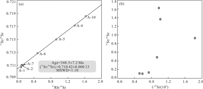
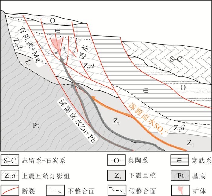
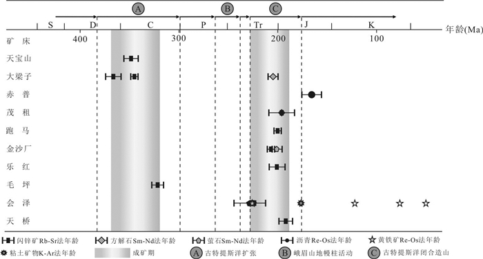
Abstract:
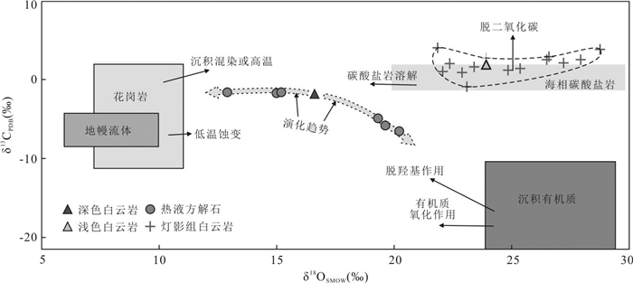
Tianbaoshan deposit is a large Pb-Zn deposit hosted in the carbonate rocks of the Upper Sinian Dengyin Formation in Sichuan-Yunnan-Guizhou district,China. Due to the lack of accurate age data of the Pb-Zn mineralization,the related regional metallotectonic setting is still controversial. In this study,we used direct Rb-Sr chronometry of sphalerite,and combined H-O and C-O isotopic analyses to constrain the mieralizating age,the possible resources of ore-forming fluids and associated tectonic setting. An effective Rb-Sr sphalerite age of 348.5±7.2 Ma (MSWD=1.10) definitely indicates that the formation of the Tianbaoshan deposit is the Early Carboniferous. The δDH2O and δ18O values of the hydrothermal minerals (-19.3‰—-58.1‰ and 1.4‰-0.6‰,respectively) are plotted in the region of the sea water interacted with organic matter in the crustal water and the drifting to the rainwater line,indicating that the mineralizing hydrothermal fluids are mixed resources derived from interaction between seawater and organic matter of sedimentary rocks,added with meteoric water. The δ13C and δ18O values of hydrothermal calcite are divided into two different groups (-1.7‰—-1.6‰ and 12.9‰-15.2‰,and -6.5‰—-4.9‰ and 19.3‰-20.2‰,respectively),suggesting that C and O compositions of hydrothermal fluids may be derived from the dissolution of host carbonates and decarboxylation of sedimentary organic matters hosted in carbonates. The (87Sr/86Sr)i ratios of sphalerite (0.710 42±0.000 13) are higher than the those of ore-hosting carbonate rocks,whereas distinctly lower than the those of basement rocks,implying that the ore-forming material is mainly derived from the mixture of the host rocks and basement rocks. So this study highlights that there are two independent lead-zinc mineralization events in Sichuan-Yunnan-Guizhou district,in which one occurs in extensional geological environments during the Late Devonian to Early Carboniferous related to the opening of the Paleo-Tethys Ocean and the other is associated with compressional geological environments from the Late Triassic to Early Jurassic related to the closure of the Paleo-Tethys Ocean,respectively.
Tianbaoshan deposit is a large Pb-Zn deposit hosted in the carbonate rocks of the Upper Sinian Dengyin Formation in Sichuan-Yunnan-Guizhou district,China. Due to the lack of accurate age data of the Pb-Zn mineralization,the related regional metallotectonic setting is still controversial. In this study,we used direct Rb-Sr chronometry of sphalerite,and combined H-O and C-O isotopic analyses to constrain the mieralizating age,the possible resources of ore-forming fluids and associated tectonic setting. An effective Rb-Sr sphalerite age of 348.5±7.2 Ma (MSWD=1.10) definitely indicates that the formation of the Tianbaoshan deposit is the Early Carboniferous. The δDH2O and δ18O values of the hydrothermal minerals (-19.3‰—-58.1‰ and 1.4‰-0.6‰,respectively) are plotted in the region of the sea water interacted with organic matter in the crustal water and the drifting to the rainwater line,indicating that the mineralizing hydrothermal fluids are mixed resources derived from interaction between seawater and organic matter of sedimentary rocks,added with meteoric water. The δ13C and δ18O values of hydrothermal calcite are divided into two different groups (-1.7‰—-1.6‰ and 12.9‰-15.2‰,and -6.5‰—-4.9‰ and 19.3‰-20.2‰,respectively),suggesting that C and O compositions of hydrothermal fluids may be derived from the dissolution of host carbonates and decarboxylation of sedimentary organic matters hosted in carbonates. The (87Sr/86Sr)i ratios of sphalerite (0.710 42±0.000 13) are higher than the those of ore-hosting carbonate rocks,whereas distinctly lower than the those of basement rocks,implying that the ore-forming material is mainly derived from the mixture of the host rocks and basement rocks. So this study highlights that there are two independent lead-zinc mineralization events in Sichuan-Yunnan-Guizhou district,in which one occurs in extensional geological environments during the Late Devonian to Early Carboniferous related to the opening of the Paleo-Tethys Ocean and the other is associated with compressional geological environments from the Late Triassic to Early Jurassic related to the closure of the Paleo-Tethys Ocean,respectively.


2019, 44(9): 3042-3059.
doi: 10.3799/dqkx.2017.592
Abstract:
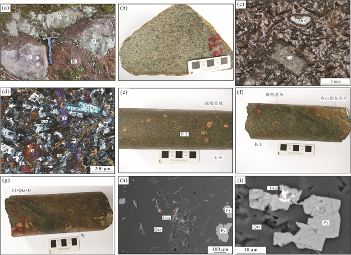
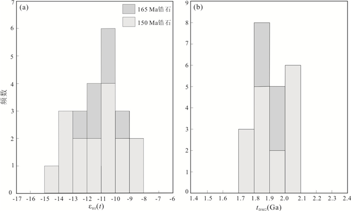
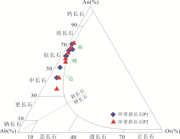
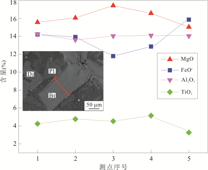
Understanding for uranium mineralization was absolutely restricted by the petrogenesis of gabbro-diorite,which emplaced into the Yanshanian biotite granite at the deep part of Changjiang uranium ore-field. We provide LA-ICP-MS zircon UPb age,Lu-Hf isotopic,mineralogical and geochemical evidence to analyse the poetrogenesis,tectonic background and its relationship with uranium mineralization. Gabbro-diorite emplaced at the Late Jurassic (LA-ICP-MS zircon U-Pb isotopic age:150±1 Ma (n=17,MSWD=0.18)) and was geochemically characteristic of within-plate basalt. The magma evolution process (ranges from basic to neutral magma) has been effectively recorded by the transformation of major elements in zoned plagioclase and biotite from gabbro-diorite. The zircon εHf(t) values range from -14.1 to -8.6 and the two-stage model ages (tDM2) range from 1.7 Ga to 2.1 Ga. The magmatic source was the relatively enriched mantle changed by the metasomatism fluid originated from the subduction zone of Pacific Ocean Plate which started from the Middle Jurassic. Gabbro-diorite has undergone a variational degree crustal contamination with the Proterozoic-Palaoproterozoic crustal material in the process of emplacement during the Late Mesozoic large scale lithosphere thining tectonic background. Gabbro-diorite provides a better reductive environment than the granite for uranium mineralization,prompting U6+ been reduced to pitchblende in the ore forming hydrothermal fluid.
Understanding for uranium mineralization was absolutely restricted by the petrogenesis of gabbro-diorite,which emplaced into the Yanshanian biotite granite at the deep part of Changjiang uranium ore-field. We provide LA-ICP-MS zircon UPb age,Lu-Hf isotopic,mineralogical and geochemical evidence to analyse the poetrogenesis,tectonic background and its relationship with uranium mineralization. Gabbro-diorite emplaced at the Late Jurassic (LA-ICP-MS zircon U-Pb isotopic age:150±1 Ma (n=17,MSWD=0.18)) and was geochemically characteristic of within-plate basalt. The magma evolution process (ranges from basic to neutral magma) has been effectively recorded by the transformation of major elements in zoned plagioclase and biotite from gabbro-diorite. The zircon εHf(t) values range from -14.1 to -8.6 and the two-stage model ages (tDM2) range from 1.7 Ga to 2.1 Ga. The magmatic source was the relatively enriched mantle changed by the metasomatism fluid originated from the subduction zone of Pacific Ocean Plate which started from the Middle Jurassic. Gabbro-diorite has undergone a variational degree crustal contamination with the Proterozoic-Palaoproterozoic crustal material in the process of emplacement during the Late Mesozoic large scale lithosphere thining tectonic background. Gabbro-diorite provides a better reductive environment than the granite for uranium mineralization,prompting U6+ been reduced to pitchblende in the ore forming hydrothermal fluid.


2019, 44(9): 3060-3073.
doi: 10.3799/dqkx.2018.114
Abstract:
The nature,type,function and mechanism of hydrocarbon fluids in Xishanyao Formation in Northwest Junggar Basin have not been systematically studied,and the genesis of the greenish alteration sandstone and its correlation with the sandstone-hosted uranium mineralization is still not clear. Through a series of measurements (e. g. rock-mineral identification,whole-rock geochemical test,fluid inclusion and C-O isotopic analysis),the mineralogical,geochemical,and isotopic characteristics have been researched for the primary gray sandstones and the greenish alteration sandstones,respectively. Petrographic observations indicate that the greenish alteration sandstones widespread a strong clay alteration (mainly montmorillonitization and chloritization),pyritization and carbonatization,and has less kaolinite content and high reduction capacity compared with the gray sandstones. The carbonate cements occurred in the greenish alteration sandstones have a light C-O isotope signature characterized by negative δ13CV-PDB values ranging from -12.8‰ to -8.6‰,and δ18OV-PDB values changing from -11.7‰ to -7.7‰. Furthermore,a large amount of methane and a little carbon dioxide have been identified within fluid inclusions. Therefore,the greenish alteration sandstones mostly experienced a reworking event by the deeply alkaline reductive hydrocarbon fluid,resulting in the concealment and protection of the paleo-oxidization sandstone belt and the early-formed uranium ore bodies,thus increasing the difficulty for prospecting. Besides,it produces the current discovered uranium ore bodies due to the interaction between the greenish sandstone and the modern uranium-bearing and oxygenated underground water.
The nature,type,function and mechanism of hydrocarbon fluids in Xishanyao Formation in Northwest Junggar Basin have not been systematically studied,and the genesis of the greenish alteration sandstone and its correlation with the sandstone-hosted uranium mineralization is still not clear. Through a series of measurements (e. g. rock-mineral identification,whole-rock geochemical test,fluid inclusion and C-O isotopic analysis),the mineralogical,geochemical,and isotopic characteristics have been researched for the primary gray sandstones and the greenish alteration sandstones,respectively. Petrographic observations indicate that the greenish alteration sandstones widespread a strong clay alteration (mainly montmorillonitization and chloritization),pyritization and carbonatization,and has less kaolinite content and high reduction capacity compared with the gray sandstones. The carbonate cements occurred in the greenish alteration sandstones have a light C-O isotope signature characterized by negative δ13CV-PDB values ranging from -12.8‰ to -8.6‰,and δ18OV-PDB values changing from -11.7‰ to -7.7‰. Furthermore,a large amount of methane and a little carbon dioxide have been identified within fluid inclusions. Therefore,the greenish alteration sandstones mostly experienced a reworking event by the deeply alkaline reductive hydrocarbon fluid,resulting in the concealment and protection of the paleo-oxidization sandstone belt and the early-formed uranium ore bodies,thus increasing the difficulty for prospecting. Besides,it produces the current discovered uranium ore bodies due to the interaction between the greenish sandstone and the modern uranium-bearing and oxygenated underground water.


2019, 44(9): 3074-3087.
doi: 10.3799/dqkx.2019.065
Abstract:
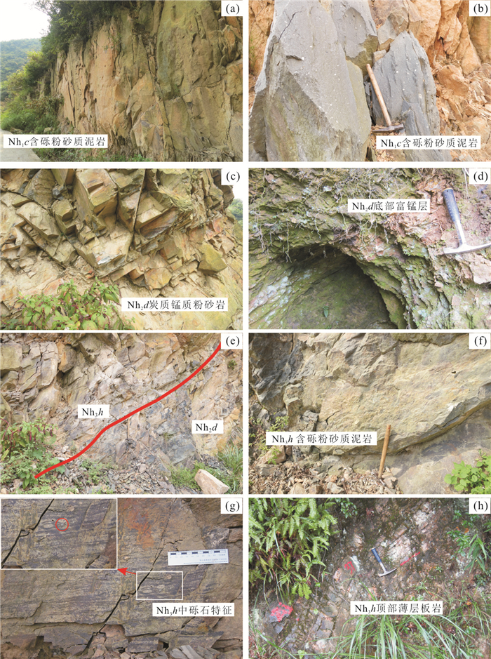
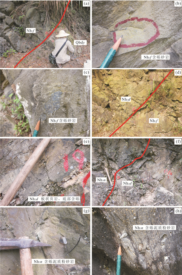
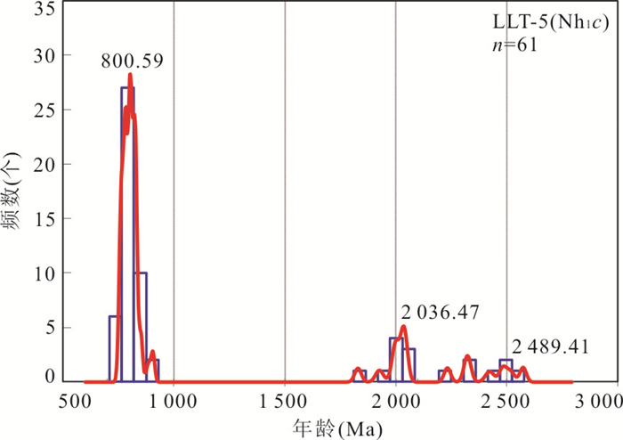
During the Late Neoproterozoic, the Middle Hunan Province was located in the Yangtze platform marginal basin, making the deposits of this area as key for stratigraphic correlations. By the sedimentary measurement of Caihuatian section in Ningxiang and Majindong sections in Taoyuan, the sequence of Nanhuan System in the Middle Hunan is defined as Changan, Fulu (Gucheng included in some areas), Datangpo and Nantuo/Hongjiang formations. And to the north of Caihuatian section, no Changan Formation has been recognized. One detrital zircon sample from the lower part of Changan Formation of Caihuatian section shows the Yangtze provenance and 752.5±4.2 Ma (n=3, MSWD=2.4) deposition age. On the basis of sedimentary characteristics and research results in the area, the Changan Glaciation might be the correspondence of the bottom part of Sturtian Glaciation (760 Ma) and Changan and Fulu (Gucheng included) formations could correspond to the whole Sturtian Glaciation with different glacial deposition phases for diverse and periodical glacier in the area. Datangpo Formation was deposited in warm climate and Nantuo/Hongjiang Formation corresponded to Marinoan. Further research should be done to identify the correlation to strata below Datangpo Formation.
During the Late Neoproterozoic, the Middle Hunan Province was located in the Yangtze platform marginal basin, making the deposits of this area as key for stratigraphic correlations. By the sedimentary measurement of Caihuatian section in Ningxiang and Majindong sections in Taoyuan, the sequence of Nanhuan System in the Middle Hunan is defined as Changan, Fulu (Gucheng included in some areas), Datangpo and Nantuo/Hongjiang formations. And to the north of Caihuatian section, no Changan Formation has been recognized. One detrital zircon sample from the lower part of Changan Formation of Caihuatian section shows the Yangtze provenance and 752.5±4.2 Ma (n=3, MSWD=2.4) deposition age. On the basis of sedimentary characteristics and research results in the area, the Changan Glaciation might be the correspondence of the bottom part of Sturtian Glaciation (760 Ma) and Changan and Fulu (Gucheng included) formations could correspond to the whole Sturtian Glaciation with different glacial deposition phases for diverse and periodical glacier in the area. Datangpo Formation was deposited in warm climate and Nantuo/Hongjiang Formation corresponded to Marinoan. Further research should be done to identify the correlation to strata below Datangpo Formation.


2019, 44(9): 3088-3100.
doi: 10.3799/dqkx.2018.186
Abstract:
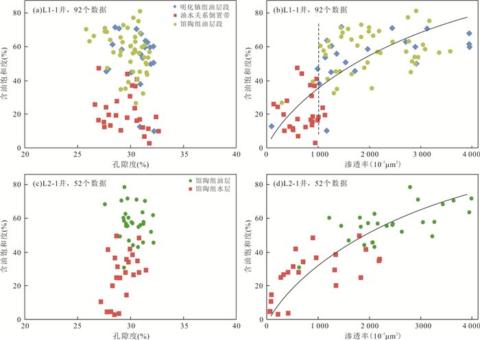
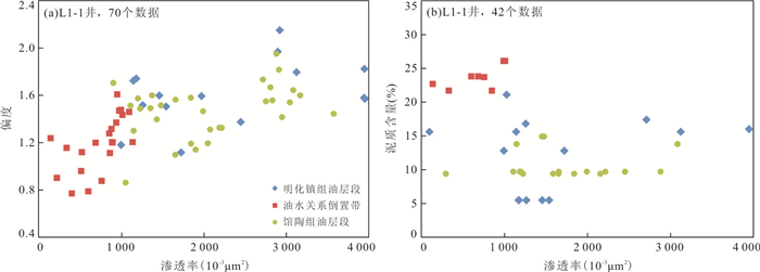
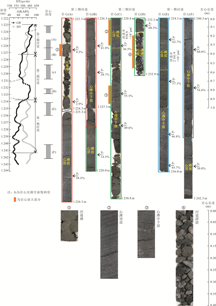
The Neogene fluvial massive extra-super heavy oil reservoir in Liaodong Bay depression is extremely special, characterized by the arc oil boundary, undulation of the oil-water interface, complex oil-water relation, and large scale oil-water relation inversion. In this paper, reservoir physical properties and oil saturation, thin section, fluid inclusions fluorescence observation, saturated hydrocarbon and aromatic hydrocarbon gas chromatography mass spectrometry have been studied. Results show that this special reservoir model is controlled by the distribution characteristics of reservoir permeability. In the vertical direction, there are three sedimentary micro-facies in the study area:channel lag deposit, central bar and flood plain, which overlap each other in the form of multi-channel rivers, showing the characteristics of cyclicity. On the top of flood plain and central bar, and the thick layer coarse clastic segment formed by multi-stage channel lag deposit, relatively poor permeability is formed because of the high content of mud and coarser clastic deposits, resulting in "physical separation layers" of different scales, which become the boundary of both oil saturation property and geochemical characteristics regular change of crude oil.
The Neogene fluvial massive extra-super heavy oil reservoir in Liaodong Bay depression is extremely special, characterized by the arc oil boundary, undulation of the oil-water interface, complex oil-water relation, and large scale oil-water relation inversion. In this paper, reservoir physical properties and oil saturation, thin section, fluid inclusions fluorescence observation, saturated hydrocarbon and aromatic hydrocarbon gas chromatography mass spectrometry have been studied. Results show that this special reservoir model is controlled by the distribution characteristics of reservoir permeability. In the vertical direction, there are three sedimentary micro-facies in the study area:channel lag deposit, central bar and flood plain, which overlap each other in the form of multi-channel rivers, showing the characteristics of cyclicity. On the top of flood plain and central bar, and the thick layer coarse clastic segment formed by multi-stage channel lag deposit, relatively poor permeability is formed because of the high content of mud and coarser clastic deposits, resulting in "physical separation layers" of different scales, which become the boundary of both oil saturation property and geochemical characteristics regular change of crude oil.


2019, 44(9): 3101-3114.
doi: 10.3799/dqkx.2017.562
Abstract:
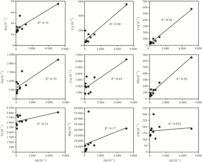
The geochemical characteristics of seawater and porewater in the deep-water basin of western Pacific and its impact on the formation of polymetallic nodules in the sea are still lacking. Seawater and porewater samples were systematically collected in western Pacific. We analyzed the hydro-chemical characteristics in seawater and trace elements in seawater and porewater. The results indicate that DO and pH values show a decrease followed by a rise with depth, whereas SiO32-, NO3- and PO43- values exhibit the reverse change trend. The variations of trace elements in seawater show a same trend with nutrient values. Trace metals in porewater are enriched in seawater-sediment interface, and then this concentration increases by degradation of authigenic material located in 3-5 cm in surface sediment. We suggest that relatively high concentration of trace metals in bottom seawater was derived from biological process, and it led to enrichment of polymetallic nodule on extensive oxic surface sediment. Compared to other areas, metal elements (Sc, Cr, Ni, Pb, especially Cu and Co) which were dissolved from detrital component, might play a key role in nodule growth in western Pacific.
The geochemical characteristics of seawater and porewater in the deep-water basin of western Pacific and its impact on the formation of polymetallic nodules in the sea are still lacking. Seawater and porewater samples were systematically collected in western Pacific. We analyzed the hydro-chemical characteristics in seawater and trace elements in seawater and porewater. The results indicate that DO and pH values show a decrease followed by a rise with depth, whereas SiO32-, NO3- and PO43- values exhibit the reverse change trend. The variations of trace elements in seawater show a same trend with nutrient values. Trace metals in porewater are enriched in seawater-sediment interface, and then this concentration increases by degradation of authigenic material located in 3-5 cm in surface sediment. We suggest that relatively high concentration of trace metals in bottom seawater was derived from biological process, and it led to enrichment of polymetallic nodule on extensive oxic surface sediment. Compared to other areas, metal elements (Sc, Cr, Ni, Pb, especially Cu and Co) which were dissolved from detrital component, might play a key role in nodule growth in western Pacific.


2019, 44(9): 3115-3134.
doi: 10.3799/dqkx.2019.081
Abstract:
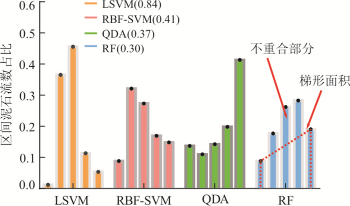
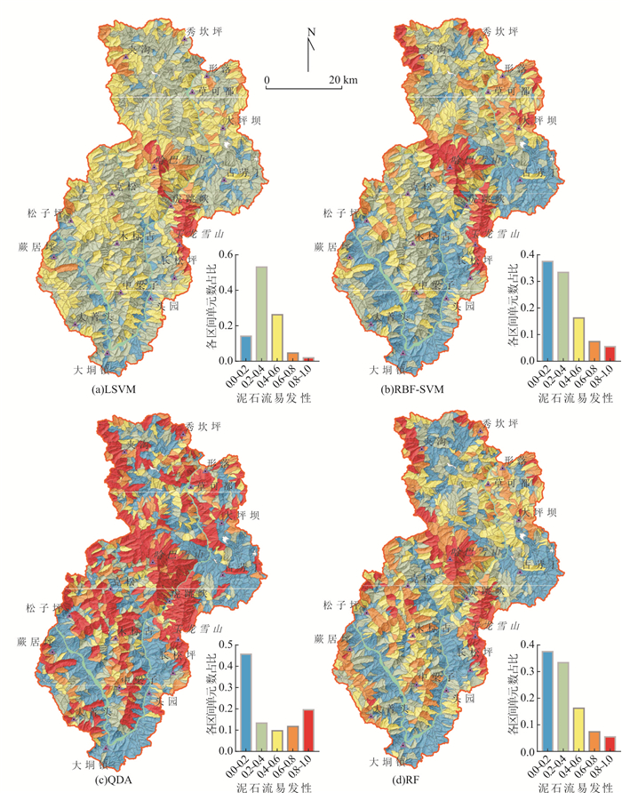
Nowadays models extensively used in GIS for debris-flow susceptibility (DFS) assessment remain obviously inadequate. In models based on classical statistical theory (e.g. information value, weight of evidence, and certainty factors), the independence between debris-flow conditioning factors is necessary, and the weight of these factors depends on the classification method. The linear machine learning may fail in nonlinear classification problems, whereas hyper-parameter tuning of usual nonlinear techniques is always difficult. Random forest (RF) is capable of resolving the most of problems of these usual models, but have hardly been applied in DFS assessment. This article aims to investigate the DFS assessment of RF and evaluate its reliability, using 4 models with the hyper-parameters tuning of Bayesian optimization, random forest (RF), linear support vector machine (LSVM), radial basis function-support vector machine (RBF-SVM), and quadratic discriminant analysis (QDA), and 26 conditioning factors. A modified five-fold cross-validation method is adopted to evaluate DFS assessment firstly, and then the rank of the relative weight of RF and Monte Carlo method are used respectively, to investigate the reliability of DFS assessment under the different combinations of debris-flow conditioning factors or the random sample split. Results demonstrate that 21 out of 26 debris-flow conditioning factors indicate the difference of the environments with different debris-flow rates. Relative weight rank of RF, can effectively determine the local optimal combination of factors for the 4 models. The uncertainty of susceptibility assessment resulting from the random sample split is most significant in the medium susceptibility zone (0.4~0.6), and can be reduced by increasing the proportion of the model building sample and improving the susceptibility model. The prediction performance of RF is:AUC=0.86, overall accuracy=0.79, F1 score=0.66 and brier score=0.14. And their reliability is optimal in all these 4 models. Therefore, RF can be a superior model for quantitative DFS assessment.
Nowadays models extensively used in GIS for debris-flow susceptibility (DFS) assessment remain obviously inadequate. In models based on classical statistical theory (e.g. information value, weight of evidence, and certainty factors), the independence between debris-flow conditioning factors is necessary, and the weight of these factors depends on the classification method. The linear machine learning may fail in nonlinear classification problems, whereas hyper-parameter tuning of usual nonlinear techniques is always difficult. Random forest (RF) is capable of resolving the most of problems of these usual models, but have hardly been applied in DFS assessment. This article aims to investigate the DFS assessment of RF and evaluate its reliability, using 4 models with the hyper-parameters tuning of Bayesian optimization, random forest (RF), linear support vector machine (LSVM), radial basis function-support vector machine (RBF-SVM), and quadratic discriminant analysis (QDA), and 26 conditioning factors. A modified five-fold cross-validation method is adopted to evaluate DFS assessment firstly, and then the rank of the relative weight of RF and Monte Carlo method are used respectively, to investigate the reliability of DFS assessment under the different combinations of debris-flow conditioning factors or the random sample split. Results demonstrate that 21 out of 26 debris-flow conditioning factors indicate the difference of the environments with different debris-flow rates. Relative weight rank of RF, can effectively determine the local optimal combination of factors for the 4 models. The uncertainty of susceptibility assessment resulting from the random sample split is most significant in the medium susceptibility zone (0.4~0.6), and can be reduced by increasing the proportion of the model building sample and improving the susceptibility model. The prediction performance of RF is:AUC=0.86, overall accuracy=0.79, F1 score=0.66 and brier score=0.14. And their reliability is optimal in all these 4 models. Therefore, RF can be a superior model for quantitative DFS assessment.


2019, 44(9): 3135-3146.
doi: 10.3799/dqkx.2019.074
Abstract:
Landslide is one of the most serious geological disasters. Finding out the morphological characteristics of landslide and the formation mechanism of landslide is of great significance to landslide stability analysis, risk management of landslide hazards and government decision-making. Previous studies on landslide morphology and its formation mechanism are seldom combined with geophysical approach. The engineering geological profile drawing is limited to the acquisition of point-level information. The combination of geophysical measurement methods is conducive to obtaining more abundant landslide geological information from two-three dimension, and to quantifying the buried depth of sliding surface and perspective sliding bed morphology more accurately. In view of this, we take the hazardous Wanzhou area in the Three Gorges reservoir area as the research object, and apply high density grid resistivity method to measure resistivity values of different depth strata in the study area, to generate twodimensional resistivity profiles for the first time so that we can further construct three-dimensional shape of sliding bed. At the same time, the important factors affecting the landslide, such as the stratum structure, the depth of the slip surface and the shape of the slip bed, are comprehensively analyzed by integration of the electrical features of the section with the borehole data and geological survey data. The results show that the high-density grid resistivity method can accurately acquire the electrical structure characteristics of the stratum and construct a three-dimensional shape of the landslide body. The measured profile shows that the Sifangbei landslide belongs to an ancient landslide, and there exists the phenomenon of drawing crack trough. By calibrating the buried depth of the slip surface obtained from the measured profile and the three-dimensional slip bed configuration, the internal structure and material composition of the landslide body can be "perspective", which provides a basis for the analysis of the formation mechanism of the landslide, as well as theoretical guidance and technical reference for the evaluation and prediction of landslide stability in the other similar regional geological surveys. The theoretical method and technical route of revealing the threedimensional morphological characteristics of typical landslides in the Three Gorges Reservoir area by high-density electrical method are successfully introduced into the analysis of landslide formation mechanism, which can provide new ideas and approach for the study of landslide formation mechanism and theory, and can be widely used in many areas.
Landslide is one of the most serious geological disasters. Finding out the morphological characteristics of landslide and the formation mechanism of landslide is of great significance to landslide stability analysis, risk management of landslide hazards and government decision-making. Previous studies on landslide morphology and its formation mechanism are seldom combined with geophysical approach. The engineering geological profile drawing is limited to the acquisition of point-level information. The combination of geophysical measurement methods is conducive to obtaining more abundant landslide geological information from two-three dimension, and to quantifying the buried depth of sliding surface and perspective sliding bed morphology more accurately. In view of this, we take the hazardous Wanzhou area in the Three Gorges reservoir area as the research object, and apply high density grid resistivity method to measure resistivity values of different depth strata in the study area, to generate twodimensional resistivity profiles for the first time so that we can further construct three-dimensional shape of sliding bed. At the same time, the important factors affecting the landslide, such as the stratum structure, the depth of the slip surface and the shape of the slip bed, are comprehensively analyzed by integration of the electrical features of the section with the borehole data and geological survey data. The results show that the high-density grid resistivity method can accurately acquire the electrical structure characteristics of the stratum and construct a three-dimensional shape of the landslide body. The measured profile shows that the Sifangbei landslide belongs to an ancient landslide, and there exists the phenomenon of drawing crack trough. By calibrating the buried depth of the slip surface obtained from the measured profile and the three-dimensional slip bed configuration, the internal structure and material composition of the landslide body can be "perspective", which provides a basis for the analysis of the formation mechanism of the landslide, as well as theoretical guidance and technical reference for the evaluation and prediction of landslide stability in the other similar regional geological surveys. The theoretical method and technical route of revealing the threedimensional morphological characteristics of typical landslides in the Three Gorges Reservoir area by high-density electrical method are successfully introduced into the analysis of landslide formation mechanism, which can provide new ideas and approach for the study of landslide formation mechanism and theory, and can be widely used in many areas.

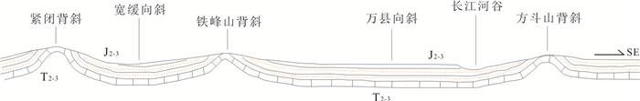


2019, 44(9): 3147-3156.
doi: 10.3799/dqkx.2017.601
Abstract:
The deep structure in the Langshan region is very developed and complex, and the magmatic rock with multiphase intrusion is controlled by deep faults. To in-depth understanding the metallogenic environment geology structure characteristics of Langshan metallogenic belt, combined with the existing geological data, this paper analyzes the geophysical field about the main tectonic zone of Langshan metallogenic belt, studies six fracture structure, the magmatic rocks distribution and the regional deep geological structure, and selects four metallogenic prospect areas. It provides basis for further studying the metallogenic potential and metallogenic environment geology structure characteristics of Langshan metallogenic belt.
The deep structure in the Langshan region is very developed and complex, and the magmatic rock with multiphase intrusion is controlled by deep faults. To in-depth understanding the metallogenic environment geology structure characteristics of Langshan metallogenic belt, combined with the existing geological data, this paper analyzes the geophysical field about the main tectonic zone of Langshan metallogenic belt, studies six fracture structure, the magmatic rocks distribution and the regional deep geological structure, and selects four metallogenic prospect areas. It provides basis for further studying the metallogenic potential and metallogenic environment geology structure characteristics of Langshan metallogenic belt.