2020 Vol. 45, No. 2
Display Method:
 PDF 247KB
2020, 45(2): 355-366.
doi: 10.3799/dqkx.2019.082
Abstract:
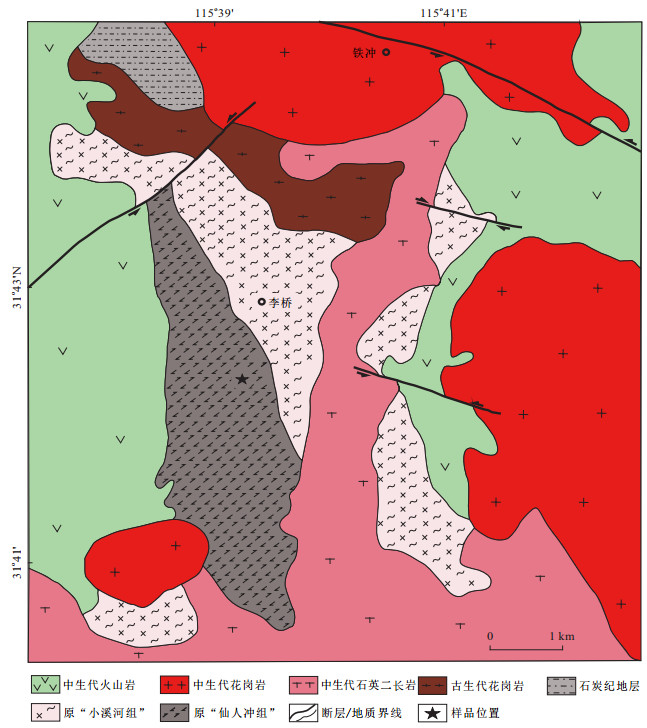
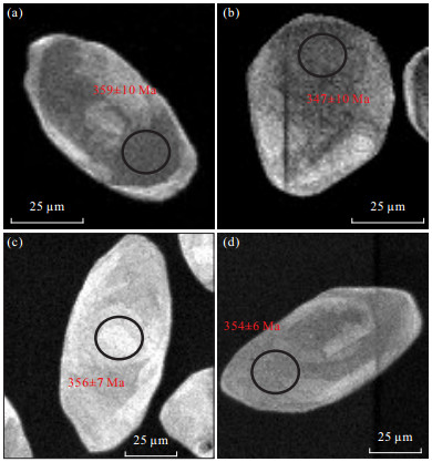
In comparison with the Triassic ultra-high-pressure metamorphic belt in the southern Dabie orogen, the Beihuaiyang zone (BZ) is generally regarded to be a relatively low-grade metamorphic unit located in the northern part of the orogen. The BZ can be subdivided into eastern and western segments separated by Shangcheng-Macheng fault zone, respectively. Among of them, the eastern segment of the BZ has no record related to Paleozoic oceanic subduction similar to those in the western segment. Also, there are rare reports on the Paleozoic magmatism and metamorphism in the region. As a result, these have greatly impeded the deep understanding and precise recognition on the formation and evolution of the Dabie orogen. The eastern segment of the BZ is mainly composed of three groups of rocks:(1) metamorphic rocks, e. g., meta-granitoid (granitic gneiss), (garnet) amphibolite, marble, mica-quartz schist and meta-flysch; (2) igneous rocks mainly including Mesozoic granite, syenite and volcanics; (3) basin sediments mainly composed of Mesozoic-Cenozoic and subordinate Carboniferous rocks. However, no petrological record of the Paleozoic metamorphism has been reported in the region. Therefore, SHRIMP zircon U-Pb dating and preliminary petrographic observations on the garnet amphibolite coexisting with marble from Tiechong, Jinzhai in the eastern segment of the BZ are carried out in this study. The results suggest that the studied rocks experienced a strong metamorphism with the peak at 355±5 Ma. It is reported for the first time on the Carboniferous metamorphism in the region, and thus provides new constraints on the eastern extension of the Qinling-Tongbai orogen and the Paleozoic tectonic evolution of the Dabie collisional orogen.
In comparison with the Triassic ultra-high-pressure metamorphic belt in the southern Dabie orogen, the Beihuaiyang zone (BZ) is generally regarded to be a relatively low-grade metamorphic unit located in the northern part of the orogen. The BZ can be subdivided into eastern and western segments separated by Shangcheng-Macheng fault zone, respectively. Among of them, the eastern segment of the BZ has no record related to Paleozoic oceanic subduction similar to those in the western segment. Also, there are rare reports on the Paleozoic magmatism and metamorphism in the region. As a result, these have greatly impeded the deep understanding and precise recognition on the formation and evolution of the Dabie orogen. The eastern segment of the BZ is mainly composed of three groups of rocks:(1) metamorphic rocks, e. g., meta-granitoid (granitic gneiss), (garnet) amphibolite, marble, mica-quartz schist and meta-flysch; (2) igneous rocks mainly including Mesozoic granite, syenite and volcanics; (3) basin sediments mainly composed of Mesozoic-Cenozoic and subordinate Carboniferous rocks. However, no petrological record of the Paleozoic metamorphism has been reported in the region. Therefore, SHRIMP zircon U-Pb dating and preliminary petrographic observations on the garnet amphibolite coexisting with marble from Tiechong, Jinzhai in the eastern segment of the BZ are carried out in this study. The results suggest that the studied rocks experienced a strong metamorphism with the peak at 355±5 Ma. It is reported for the first time on the Carboniferous metamorphism in the region, and thus provides new constraints on the eastern extension of the Qinling-Tongbai orogen and the Paleozoic tectonic evolution of the Dabie collisional orogen.


2020, 45(2): 367-373.
doi: 10.3799/dqkx.2018.391
Abstract:
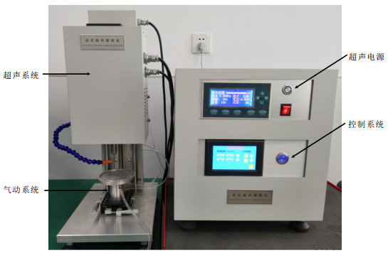
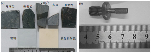
The preparation of small-size cylindrical rock samples from the rock samples collected in field or synthesized in the laboratory is an important procedure for high-pressure and high-temperature rock physics experiments in geosciences. The brittle hardness and in homogeneity of rock samples can affect significantly the stability and coring quality of conventional rock core grinding process. To overcome this technique difficulty, we combined the techniques of rotary ultrasonic vibration and rock grinding and developed a flexible high-pressure air-operated sample feeding system along the vertical direction in a bench-top rotary ultrasonic rock coring device. This device can realize high-precision automatic coring and grinding of small-size cylindrical rock specimen.The coring tests on rock specimens of various hardness show that the new device can conduct high-efficiency and highquality small-diameter sample coring and satisfy the high-standard requirements of high-pressure and high-temperature geological experiments.
The preparation of small-size cylindrical rock samples from the rock samples collected in field or synthesized in the laboratory is an important procedure for high-pressure and high-temperature rock physics experiments in geosciences. The brittle hardness and in homogeneity of rock samples can affect significantly the stability and coring quality of conventional rock core grinding process. To overcome this technique difficulty, we combined the techniques of rotary ultrasonic vibration and rock grinding and developed a flexible high-pressure air-operated sample feeding system along the vertical direction in a bench-top rotary ultrasonic rock coring device. This device can realize high-precision automatic coring and grinding of small-size cylindrical rock specimen.The coring tests on rock specimens of various hardness show that the new device can conduct high-efficiency and highquality small-diameter sample coring and satisfy the high-standard requirements of high-pressure and high-temperature geological experiments.


2020, 45(2): 374-388.
doi: 10.3799/dqkx.2019.013
Abstract:
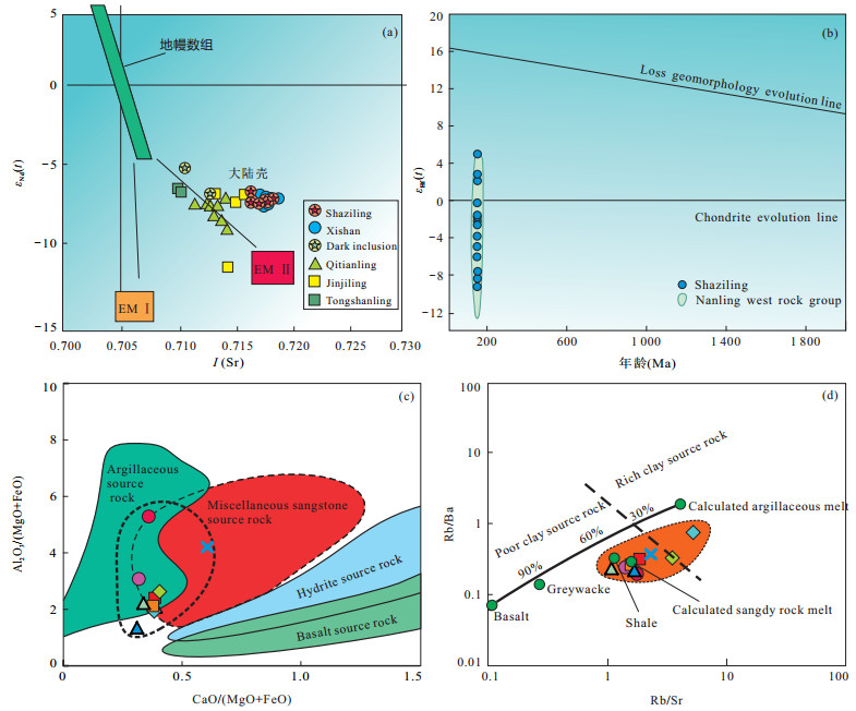
A study of LA-ICP-MS zircon U-Pb dating for Shaziling pluton composed of granodiorites and monzogranites from Jiuyishan area considered as a part of Nanling granite belt was carried out. The results of chronology indicate that the Shaziling pluton was formed during the early Yanshanian (151.9±1.1-154.1±1.2 Ma) instead of the Indosinian. The analyses of geochemistry indicate that the Shaziling pluton was characterized by rich silicon-alkali and poor calcium-magnesium with K2O/Na2O ratios of 1.37-2.65, Al2O3 of 0.93-1.09 and FeO*/MgO ratios of 5.43-15.33 (average 7.14); The content of rare earth elements in the range of 186.75 to 413.17×10⁻⁶ is significantly higher than the those of world average granite, which shows the right-leaning distribution of enriched light rare earth elements with obvious negative anomaly of Eu and δEu values of 0.095-0.224. These rocks are enriched in large ion lithophile elements (LILEs, e.g., Ga, Y, Nb, Zr, and Hf) and relatively depleted in high field strength elements (HFSEs, e.g., Ni, Cr, Eu, Ti, V, P, and Sr), with Ga/Al ratios of (245~582)×10-6 (average 350×10-6) and Zr+Nb+Ce+Y of (256.8-630.7)×10-6 (average 441.95×10⁻⁶), similar to geochemical features of A-type granites, which indicates the Shaziling pluton formed in the post- orogenic environment of the extensional tectonic system. Sr, Nd and Hf isotopes show that the Shaziling pluton has higher initial Sr isotope values of 0.71603 to 0.71817, lower εNd(t) values of -6.8 to -7.4 and εHf(t) values of 4.8 to -14.2, revealing that the source area occurred partial melting of crustal graywacke/pelite with a contribution of mantle materials during the diagenesis. Nd and Hf are relatively close in mode ages, with 1 498-1 546 Ma and 1 061-1 756 Ma, respectively, suggesting that the source rocks separated from the mantle reservoir during the Mesoproterozoic. Combined with the geological evolution of Nanling area that was in the tectonic setting of plate juncture zone and post-arc extension of Pacific plate, magmatism occurred in the Mesozoic Jiuyishan area in which the structure is relatively weak and there are a lot of new crustal materials with higher Lu/Hf and Sm/Nd isotope ratios. The Shaziling and Jiuyishan complex massif, similar to isotopic composition of A-type granites was formed by partial melting of the source area caused by mantle convection and upwelling of asthenosphere.
A study of LA-ICP-MS zircon U-Pb dating for Shaziling pluton composed of granodiorites and monzogranites from Jiuyishan area considered as a part of Nanling granite belt was carried out. The results of chronology indicate that the Shaziling pluton was formed during the early Yanshanian (151.9±1.1-154.1±1.2 Ma) instead of the Indosinian. The analyses of geochemistry indicate that the Shaziling pluton was characterized by rich silicon-alkali and poor calcium-magnesium with K2O/Na2O ratios of 1.37-2.65, Al2O3 of 0.93-1.09 and FeO*/MgO ratios of 5.43-15.33 (average 7.14); The content of rare earth elements in the range of 186.75 to 413.17×10⁻⁶ is significantly higher than the those of world average granite, which shows the right-leaning distribution of enriched light rare earth elements with obvious negative anomaly of Eu and δEu values of 0.095-0.224. These rocks are enriched in large ion lithophile elements (LILEs, e.g., Ga, Y, Nb, Zr, and Hf) and relatively depleted in high field strength elements (HFSEs, e.g., Ni, Cr, Eu, Ti, V, P, and Sr), with Ga/Al ratios of (245~582)×10-6 (average 350×10-6) and Zr+Nb+Ce+Y of (256.8-630.7)×10-6 (average 441.95×10⁻⁶), similar to geochemical features of A-type granites, which indicates the Shaziling pluton formed in the post- orogenic environment of the extensional tectonic system. Sr, Nd and Hf isotopes show that the Shaziling pluton has higher initial Sr isotope values of 0.71603 to 0.71817, lower εNd(t) values of -6.8 to -7.4 and εHf(t) values of 4.8 to -14.2, revealing that the source area occurred partial melting of crustal graywacke/pelite with a contribution of mantle materials during the diagenesis. Nd and Hf are relatively close in mode ages, with 1 498-1 546 Ma and 1 061-1 756 Ma, respectively, suggesting that the source rocks separated from the mantle reservoir during the Mesoproterozoic. Combined with the geological evolution of Nanling area that was in the tectonic setting of plate juncture zone and post-arc extension of Pacific plate, magmatism occurred in the Mesozoic Jiuyishan area in which the structure is relatively weak and there are a lot of new crustal materials with higher Lu/Hf and Sm/Nd isotope ratios. The Shaziling and Jiuyishan complex massif, similar to isotopic composition of A-type granites was formed by partial melting of the source area caused by mantle convection and upwelling of asthenosphere.


2020, 45(2): 389-399.
doi: 10.3799/dqkx.2018.395
Abstract:
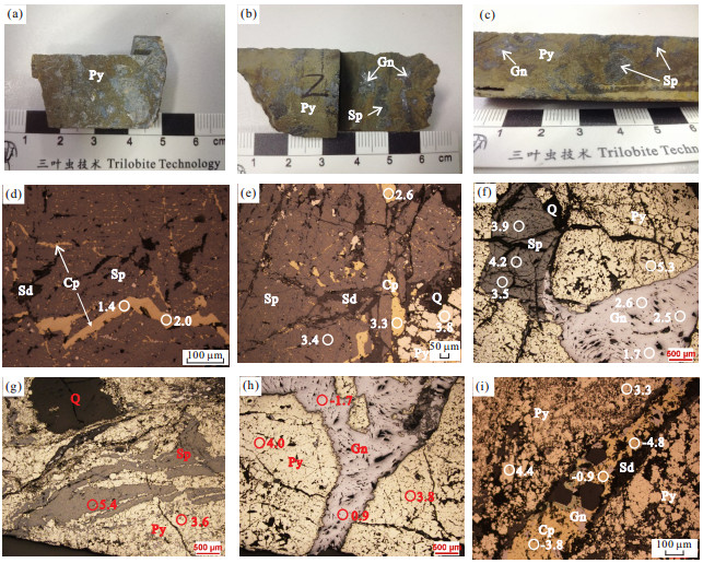
In recent years, the Pb-Zn mineralization was discovered in the Niutoushan area in the west part of the Xiangshan volcanic basin. The genetic mechanism of Pb-Zn mineralization is still unclear. In order to reveal the source of the Pb-Zn mineralization, in-situ sulfur isotope analysis using laser altered-inductively coupled plasma spectra(LA-MC-ICP-MS)of sulfides is carried out. Paragenetic and crosscutting relationship between sulfide minerals formed by the hydrothermal fluids suggest that the earliest precipitated mineral was pyrite, followed by galena and sphalerite, and the chalcopyrite in fine vein shape was formed at the latest stage of the hydrothermal fluids. The analytical results of this study indicate that the δ34S values of metal sulfide minerals (pyrite, sphalerite, galena and fine-vine chalcopyrite) range from -4.8‰~+5.4‰. In term of sulfur isotopes, not all the sulfide minerals are in completely isotope equilibrium. The δ34SΣS(total sulfur isotope) value of the mineralized fluid calculated from the δ34S values of pyrite at its formation temperature is +3.7‰, which is basically consistent with hydrothermal δ34SΣSvalue obtained from the δ34S values of the paragenetic mineral pair (sphalerite-galena).Therefore, the δ34SΣSvalue of the mineralization fluid(+3.7‰) in the Niutoushan Pb-Zn mineralization indicates that the mineralization fluid was magmatic in origin. Combined with the published dating data of the magmatic rocks of the Xiangshan volcanic basin, the sulfur isotope data of this study suggest that hydrothermal fluid of the Pb-Zn mineralization may have been mainly derived from the subvolcanic magma of the granitic porphyry. The sulfur isotope values of the sphalerite minerals were higher than those of the paragenetic galena in the mineralized bodies, indicating sulfur isotope equilibrium between these two minerals. The temperatures calculated by using the sulfur isotopic compositions of these two minerals are between 197℃ and 476℃, which is consistent with the published temperatures from fluid inclusions. The metallogenic conditions and sources of ore-forming materials of the Niutoushan Pb-Zn mineralization in the Xiangshan volcanic basin are similar to those of Pb-Zn ore deposits in the Huanggangshan and Lizikeng volcanic basins in Northern Wuyi area, which hints promising prospects for Pb-Zn deposit prospecting in the Xiangshan volcanic basin.
In recent years, the Pb-Zn mineralization was discovered in the Niutoushan area in the west part of the Xiangshan volcanic basin. The genetic mechanism of Pb-Zn mineralization is still unclear. In order to reveal the source of the Pb-Zn mineralization, in-situ sulfur isotope analysis using laser altered-inductively coupled plasma spectra(LA-MC-ICP-MS)of sulfides is carried out. Paragenetic and crosscutting relationship between sulfide minerals formed by the hydrothermal fluids suggest that the earliest precipitated mineral was pyrite, followed by galena and sphalerite, and the chalcopyrite in fine vein shape was formed at the latest stage of the hydrothermal fluids. The analytical results of this study indicate that the δ34S values of metal sulfide minerals (pyrite, sphalerite, galena and fine-vine chalcopyrite) range from -4.8‰~+5.4‰. In term of sulfur isotopes, not all the sulfide minerals are in completely isotope equilibrium. The δ34SΣS(total sulfur isotope) value of the mineralized fluid calculated from the δ34S values of pyrite at its formation temperature is +3.7‰, which is basically consistent with hydrothermal δ34SΣSvalue obtained from the δ34S values of the paragenetic mineral pair (sphalerite-galena).Therefore, the δ34SΣSvalue of the mineralization fluid(+3.7‰) in the Niutoushan Pb-Zn mineralization indicates that the mineralization fluid was magmatic in origin. Combined with the published dating data of the magmatic rocks of the Xiangshan volcanic basin, the sulfur isotope data of this study suggest that hydrothermal fluid of the Pb-Zn mineralization may have been mainly derived from the subvolcanic magma of the granitic porphyry. The sulfur isotope values of the sphalerite minerals were higher than those of the paragenetic galena in the mineralized bodies, indicating sulfur isotope equilibrium between these two minerals. The temperatures calculated by using the sulfur isotopic compositions of these two minerals are between 197℃ and 476℃, which is consistent with the published temperatures from fluid inclusions. The metallogenic conditions and sources of ore-forming materials of the Niutoushan Pb-Zn mineralization in the Xiangshan volcanic basin are similar to those of Pb-Zn ore deposits in the Huanggangshan and Lizikeng volcanic basins in Northern Wuyi area, which hints promising prospects for Pb-Zn deposit prospecting in the Xiangshan volcanic basin.


2020, 45(2): 400-418.
doi: 10.3799/dqkx.2018.393
Abstract:
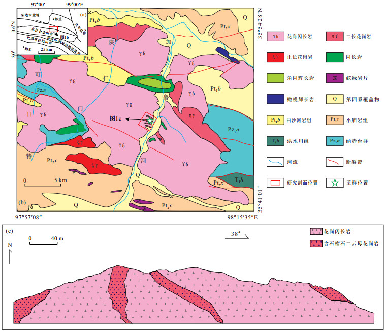
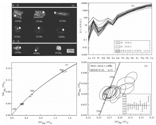
Late Paleozoic to Early Mesozoic I-type granodiorites enriched in mafic microgranular enclaves are widespread in Eastern Kunlun orogen, which therefore has been considered as a natural laboratory for studying magma mixing between mantle- and crust-derived melts. In contrast, coeval peraluminum to strong peraluminous granitoids are rarely reported in this region. Recently, we identified a set of garnet-bearing two-mica granites in the Jialuhe region at eastern part of the East Kunlun Orogen. Hereby we present a synthetical mineralogy, petrology, zircon U-Pb geochronology, and lithogeochemistry and Lu-Hf isotope study on it, aiming to constrain its petrogenesis and tectonic implications. The rock outcropped as multiple sub-parallel dykes in the field, intruding into granodiorite. It mainly consists of quartz, plagioclase, k-feldspar, biotite and muscovite, with minor garnet as accessory minerals. LA-ICP-MS zircon U-Pb isotopic dating yields an age of 242.0±1.4 Ma, indicating that the garnet-bearing two-mica granites were formed in the Middle Triassic. Chemical analyses show that the rocks have characteristics of high SiO2(74.49%~75.24%), K2O(4.21%~4.33%), but low P2O5(0.02%~0.03%) contents, belonging to peraluminous to strong peraluminous series (A/CNK=1.08~1.12), showing a high degree of differentiation. They are relatively enriched in elements such as U, Th, Pb, Rb, but depleted in Nb, Ta and other related elements. Note that, P and Ti are strongly depleted, which may indicate early crystallization of apatite and titanomagnetite. The rocks also have a low total amounts of rare earth elements (61.55×10⁻⁶~119.05×10⁻⁶), and show a weak negative Eu anomaly (δEu=0.51~0.65). Their zircon εHf(t) values ranged from -8.19 to -2.78 (mean of -5.61), with a two-stage model ages (TDM2) of 1.3 Ga to 1.6 Ga Ma and whole-rock Nb/Ta ratios are 8.22~9.67 (close to continental crust ratio of 10.91). These features are similar to those of nearly coeval biotite monzogranite in the region, indicating that the rocks may be originated from remelting of lower crust. The biotite-rich enclaves are widely developed in the rocks, suggesting that the wall rock materials are captured during magma ascent, with obvious assimilation and contamination. Thus, we propose that the garnet-bearing two-mica granitic dykes belong to high-fractionated and peraluminous to strongly peraluminous I-type granites series, which are products of felsic magma produced by partial melting of lower crust undergoing long-term fractionation and being subjected to surrounding rocks assimilation during its ascent.
Late Paleozoic to Early Mesozoic I-type granodiorites enriched in mafic microgranular enclaves are widespread in Eastern Kunlun orogen, which therefore has been considered as a natural laboratory for studying magma mixing between mantle- and crust-derived melts. In contrast, coeval peraluminum to strong peraluminous granitoids are rarely reported in this region. Recently, we identified a set of garnet-bearing two-mica granites in the Jialuhe region at eastern part of the East Kunlun Orogen. Hereby we present a synthetical mineralogy, petrology, zircon U-Pb geochronology, and lithogeochemistry and Lu-Hf isotope study on it, aiming to constrain its petrogenesis and tectonic implications. The rock outcropped as multiple sub-parallel dykes in the field, intruding into granodiorite. It mainly consists of quartz, plagioclase, k-feldspar, biotite and muscovite, with minor garnet as accessory minerals. LA-ICP-MS zircon U-Pb isotopic dating yields an age of 242.0±1.4 Ma, indicating that the garnet-bearing two-mica granites were formed in the Middle Triassic. Chemical analyses show that the rocks have characteristics of high SiO2(74.49%~75.24%), K2O(4.21%~4.33%), but low P2O5(0.02%~0.03%) contents, belonging to peraluminous to strong peraluminous series (A/CNK=1.08~1.12), showing a high degree of differentiation. They are relatively enriched in elements such as U, Th, Pb, Rb, but depleted in Nb, Ta and other related elements. Note that, P and Ti are strongly depleted, which may indicate early crystallization of apatite and titanomagnetite. The rocks also have a low total amounts of rare earth elements (61.55×10⁻⁶~119.05×10⁻⁶), and show a weak negative Eu anomaly (δEu=0.51~0.65). Their zircon εHf(t) values ranged from -8.19 to -2.78 (mean of -5.61), with a two-stage model ages (TDM2) of 1.3 Ga to 1.6 Ga Ma and whole-rock Nb/Ta ratios are 8.22~9.67 (close to continental crust ratio of 10.91). These features are similar to those of nearly coeval biotite monzogranite in the region, indicating that the rocks may be originated from remelting of lower crust. The biotite-rich enclaves are widely developed in the rocks, suggesting that the wall rock materials are captured during magma ascent, with obvious assimilation and contamination. Thus, we propose that the garnet-bearing two-mica granitic dykes belong to high-fractionated and peraluminous to strongly peraluminous I-type granites series, which are products of felsic magma produced by partial melting of lower crust undergoing long-term fractionation and being subjected to surrounding rocks assimilation during its ascent.


2020, 45(2): 419-433.
doi: 10.3799/dqkx.2019.058
Abstract:
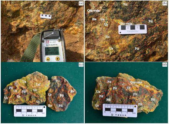
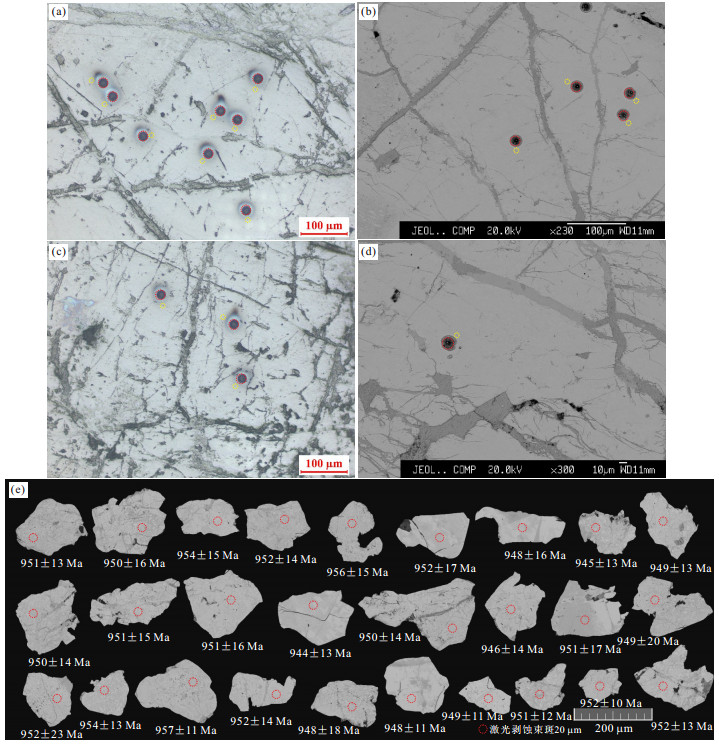
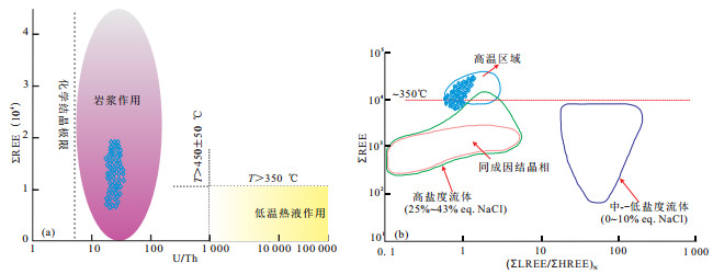
The 1101 uranium ore area is one of the representative uranium deposits, which has high-grade and larger uraninite. In order to know the genesis and metallogenic age of the pitchblende, the in-situ analytical technologies(EPMA、SEM、LA-ICP-MS) was applied to analyze the three pitchblende samples.The chemical composition of EPMA indicate that pitchblende exhibits high contents of PbO, ThO2, Y2O3 and low SiO2, Na2O, CaO, K2O, ZrO2, which shows that it has suffered less alteration after crystallization.The REE diagram of(ΣREE-(U/Th), ΣREE-(ΣREE/ΣREE)N)reflects that these pitchblend crystalized in the condition of magamatic process, related to a high temperature environment(T>450℃).The LA-ICP-MS of pitchblende U-Pb dating yields the age of (950±5 Ma, MSWD=0.025, 953±9 Ma, MSWD=0.051, 954±8 Ma, MSWD=0.085), providing the metallogenic age constraint on the 1101 uranium ore area(Late-Neoproterozoic).Compared with different types of uranium deposits abroad, the 1101 uranium ore was of magamatic origin that had undergone the process of migmatization.The Rondinia super continent was in the transition from convergence to split at the period of Late-Neoproterozoic, which led to the Pt1j strata generated regional metamorphism, migmatization and uranium mineralization.The metallogenic age ca.960 Ma of 1101 uranium deposit corresponds to the Jinningian tectonic movement, which belongs to the Rondinia supercontinenal spilitting geological event.
The 1101 uranium ore area is one of the representative uranium deposits, which has high-grade and larger uraninite. In order to know the genesis and metallogenic age of the pitchblende, the in-situ analytical technologies(EPMA、SEM、LA-ICP-MS) was applied to analyze the three pitchblende samples.The chemical composition of EPMA indicate that pitchblende exhibits high contents of PbO, ThO2, Y2O3 and low SiO2, Na2O, CaO, K2O, ZrO2, which shows that it has suffered less alteration after crystallization.The REE diagram of(ΣREE-(U/Th), ΣREE-(ΣREE/ΣREE)N)reflects that these pitchblend crystalized in the condition of magamatic process, related to a high temperature environment(T>450℃).The LA-ICP-MS of pitchblende U-Pb dating yields the age of (950±5 Ma, MSWD=0.025, 953±9 Ma, MSWD=0.051, 954±8 Ma, MSWD=0.085), providing the metallogenic age constraint on the 1101 uranium ore area(Late-Neoproterozoic).Compared with different types of uranium deposits abroad, the 1101 uranium ore was of magamatic origin that had undergone the process of migmatization.The Rondinia super continent was in the transition from convergence to split at the period of Late-Neoproterozoic, which led to the Pt1j strata generated regional metamorphism, migmatization and uranium mineralization.The metallogenic age ca.960 Ma of 1101 uranium deposit corresponds to the Jinningian tectonic movement, which belongs to the Rondinia supercontinenal spilitting geological event.


2020, 45(2): 434-450.
doi: 10.3799/dqkx.2018.348
Abstract:
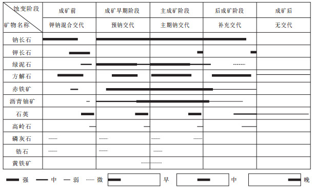
The Jiling Na-metasomatic uranium deposit is one of the most important deposits in the Longshou mountains ore belt, which is a key to the research on uranium mineralization in this area. Based on the logging data, microscope analysis, electronic probe and geochemical characteristics, we divide hydrothermal process into 5 stages including premetallogenic, early metallogenic, main metallogenic, post-metallogenic and after metallogenic stage. The alteration zones can be divided into zone A to zone F from the ore center to the alteration outer, and their geochemical characteristics are as follows:Na2O and U contents decreasing distinctly from zone A to zone F; SiO2 and Rb contents show a relieved "U" type; FeO and MgO contents show bimodal in zone A and zone E, while P2O5and HREEs contents are relatively higher in zone A and Zone D; TiO2, Fe2O3, CaO, MnO, CO2, Zr, V, Cs and REEs contents are distinctly higher in zones B, C and D. The ore forming hydrothermal solution is rebalanced magma water, which is rich in Na+, U6+ and CO32-. Pitchblende was downloaded from hydrothermal solution by fluid boiling for pressure releasing suddenly, and the changing of pH and Eh promoted the conversion from U6+ to U4+. It could be hoped for a large scale uranium base are to be found under the guidance of altered mineral assemblages diagram in deep prospecting and ore forecasting.
The Jiling Na-metasomatic uranium deposit is one of the most important deposits in the Longshou mountains ore belt, which is a key to the research on uranium mineralization in this area. Based on the logging data, microscope analysis, electronic probe and geochemical characteristics, we divide hydrothermal process into 5 stages including premetallogenic, early metallogenic, main metallogenic, post-metallogenic and after metallogenic stage. The alteration zones can be divided into zone A to zone F from the ore center to the alteration outer, and their geochemical characteristics are as follows:Na2O and U contents decreasing distinctly from zone A to zone F; SiO2 and Rb contents show a relieved "U" type; FeO and MgO contents show bimodal in zone A and zone E, while P2O5and HREEs contents are relatively higher in zone A and Zone D; TiO2, Fe2O3, CaO, MnO, CO2, Zr, V, Cs and REEs contents are distinctly higher in zones B, C and D. The ore forming hydrothermal solution is rebalanced magma water, which is rich in Na+, U6+ and CO32-. Pitchblende was downloaded from hydrothermal solution by fluid boiling for pressure releasing suddenly, and the changing of pH and Eh promoted the conversion from U6+ to U4+. It could be hoped for a large scale uranium base are to be found under the guidance of altered mineral assemblages diagram in deep prospecting and ore forecasting.


2020, 45(2): 451-466.
doi: 10.3799/dqkx.2018.376
Abstract:
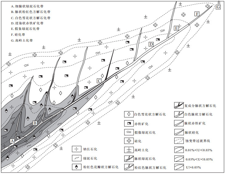
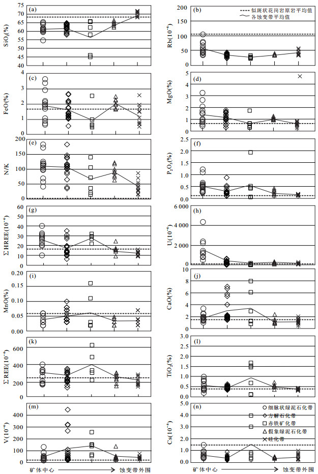
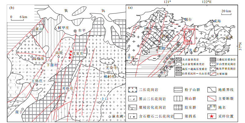
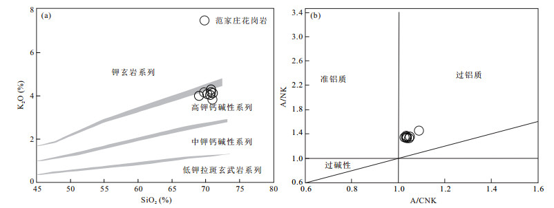
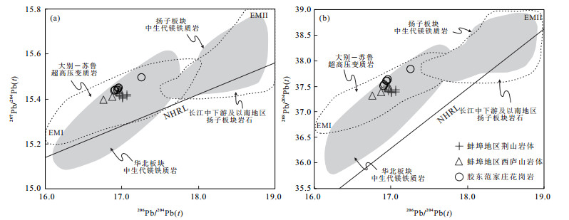
A series of late Jurassic adakitic rocks are widely developed in the Jiaodong Peninsula, eastern China, and their petrogenesis and tectonic setting provide important evidence for Mesozoic tectonic evolution in Jiaodong area. In this study, we investigate the bulk-rock major element, trace element and Sr-Nd-Pb isotopes of the granitoid exposed in the Fanjiazhuang area. LA-ICP-MS zircon U-Pb dating results yield a weighted mean 206Pb/238U age of 161±2 Ma for the Fanjiazhuang granitoid. Geochemical data indicate that the intrusion is characterized by high SiO2(68.94%-71.00%), Al2O3(>15.17%), Sr but low MgO(0.32%-0.41%), Y and Yb contents, and high Sr/Y and La/Yb ratios. The rocks exhibit high initial 87Sr/86Sr ratios (0.709 28 to 0.711 41), low εNd(t) (-20.5 to -14.1) and they are characterized by high radiogenic Pb isotopic compositions with (206Pb/204Pb)t=16.853-17.207, (207Pb/204Pb)t=15.436-15.495, (208Pb/204Pb)t=37.340-37.629. The elemental and isotopic data suggest that the late Jurassic low-Mg adakitic granites in Fanjiazhuang area were derived from the partial melting of the thickened lower crust. The results show that the magma sources were dominated by lower crust of the Yangtze Block and with subordinate lower crust of the North China Block. The Izanagi plate subduction was the most likely geodynamic force for formation of the Jurassic Fanjiazhuang low-Mg adakatic granite in the Jiaodong Peninsula.
A series of late Jurassic adakitic rocks are widely developed in the Jiaodong Peninsula, eastern China, and their petrogenesis and tectonic setting provide important evidence for Mesozoic tectonic evolution in Jiaodong area. In this study, we investigate the bulk-rock major element, trace element and Sr-Nd-Pb isotopes of the granitoid exposed in the Fanjiazhuang area. LA-ICP-MS zircon U-Pb dating results yield a weighted mean 206Pb/238U age of 161±2 Ma for the Fanjiazhuang granitoid. Geochemical data indicate that the intrusion is characterized by high SiO2(68.94%-71.00%), Al2O3(>15.17%), Sr but low MgO(0.32%-0.41%), Y and Yb contents, and high Sr/Y and La/Yb ratios. The rocks exhibit high initial 87Sr/86Sr ratios (0.709 28 to 0.711 41), low εNd(t) (-20.5 to -14.1) and they are characterized by high radiogenic Pb isotopic compositions with (206Pb/204Pb)t=16.853-17.207, (207Pb/204Pb)t=15.436-15.495, (208Pb/204Pb)t=37.340-37.629. The elemental and isotopic data suggest that the late Jurassic low-Mg adakitic granites in Fanjiazhuang area were derived from the partial melting of the thickened lower crust. The results show that the magma sources were dominated by lower crust of the Yangtze Block and with subordinate lower crust of the North China Block. The Izanagi plate subduction was the most likely geodynamic force for formation of the Jurassic Fanjiazhuang low-Mg adakatic granite in the Jiaodong Peninsula.


2020, 45(2): 479-488.
doi: 10.3799/dqkx.2019.011
Abstract:
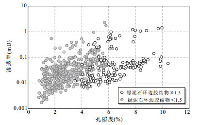
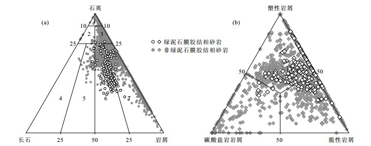
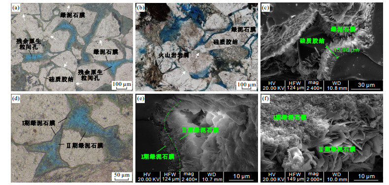
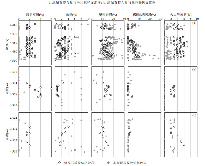
The sandstones reservoirs of the Xujiahe Formation in the Yuanba and Tongnanba area, Sichuan Basin have poor qualities, and only those with chlorite rim, which has a content of more than 1.5% (i.e. chlorite-cemented facies) show a higher porosity. Based on lithology and well-logging geology, composition and control factors of formation of sandstones with chloritecemented facies are analysed with thin section analysis, scanning electron microscopic analysis and grain size analysis, well log responses and distribution of sandstones with chlorite-cemented facies are identified with thin section and well logging data. The formation of chlorite rim has strong environmental specificity and sandstone composition selectivity, that is, it develops in the sandstones with good original porosity in the subaqueous distributary channel. Sandstone with chlorite-cemented facies has higher texture maturity and composition maturity, with lower contents of matrix and plastic rock fragment, and it also has a certain amount of volcanic rock fragments (2%~6%). Lower contents of matrix and plastic rock fragment provided space for precipitation of chlorite, and volcanic rock fragments provided source of chlorite precipitation.
The sandstones reservoirs of the Xujiahe Formation in the Yuanba and Tongnanba area, Sichuan Basin have poor qualities, and only those with chlorite rim, which has a content of more than 1.5% (i.e. chlorite-cemented facies) show a higher porosity. Based on lithology and well-logging geology, composition and control factors of formation of sandstones with chloritecemented facies are analysed with thin section analysis, scanning electron microscopic analysis and grain size analysis, well log responses and distribution of sandstones with chlorite-cemented facies are identified with thin section and well logging data. The formation of chlorite rim has strong environmental specificity and sandstone composition selectivity, that is, it develops in the sandstones with good original porosity in the subaqueous distributary channel. Sandstone with chlorite-cemented facies has higher texture maturity and composition maturity, with lower contents of matrix and plastic rock fragment, and it also has a certain amount of volcanic rock fragments (2%~6%). Lower contents of matrix and plastic rock fragment provided space for precipitation of chlorite, and volcanic rock fragments provided source of chlorite precipitation.


2020, 45(2): 489-502.
doi: 10.3799/dqkx.2018.367
Abstract:
The series of metamorphic rocks outcropped in the Great Xing'an Range area such as Xinghuadukou Group and Luomahu Group have been considered as the metamorphic basement of the Erguna massif and Xing'an block in the eastern part of the Central Asian Orogenic Belt, but there is a great controversy over the age of its formation, which restricts the study of the regional tectonic evolution. In order to ascertain the protolith age of the Luomahu Group in the northeast of Xing' an block, this paper selects two mica schists to carry out the study of LA-ICP-MS U-Pb age of detrital zircon, and analyzes the characteristics of the provenances and the maximum sedimentary limit. The results show that the dated detrital zircons from two samples are the magmatic origin zircons, and have similar age population, which concentrated in 7 intervals as 400-430 Ma, 430-465 Ma, 470-520 Ma, 630-715 Ma, 750-830 Ma, 880-940 Ma and 1 720-1 870 Ma mainly. Combined the regional geological composition, the detrital zircon population reflects that the provenance was complex and had large space time range, but the early Paleozoic magmatic rocks from adjacent area were the main provenance, and the Proterozoic magmatic rocks and metamorphic rocks from the Erguna massif maybe another important source. Based on the minimum age of detrital zircon, it could be determined that the upper limit of sedimentary age of the protolith was Early Devonian, rather than from the Neoproterozoic to Early Cambrian as originally thought. According to the comparison of the sedimentary formation, it is inferred that the Luomahu Group may be deposited contemporaneously with the Upper Silurian-Lower Devonian series (such as the Woduhe Formation and the Niqiuhe Formation) at the same tectonic environment, and the existing differences may be caused by experiencing different metamorphisms at the later stages. The deformation and metamorphism might be related to the closure of the Mongol-Okhotsk Ocean during the Mesozoic.
The series of metamorphic rocks outcropped in the Great Xing'an Range area such as Xinghuadukou Group and Luomahu Group have been considered as the metamorphic basement of the Erguna massif and Xing'an block in the eastern part of the Central Asian Orogenic Belt, but there is a great controversy over the age of its formation, which restricts the study of the regional tectonic evolution. In order to ascertain the protolith age of the Luomahu Group in the northeast of Xing' an block, this paper selects two mica schists to carry out the study of LA-ICP-MS U-Pb age of detrital zircon, and analyzes the characteristics of the provenances and the maximum sedimentary limit. The results show that the dated detrital zircons from two samples are the magmatic origin zircons, and have similar age population, which concentrated in 7 intervals as 400-430 Ma, 430-465 Ma, 470-520 Ma, 630-715 Ma, 750-830 Ma, 880-940 Ma and 1 720-1 870 Ma mainly. Combined the regional geological composition, the detrital zircon population reflects that the provenance was complex and had large space time range, but the early Paleozoic magmatic rocks from adjacent area were the main provenance, and the Proterozoic magmatic rocks and metamorphic rocks from the Erguna massif maybe another important source. Based on the minimum age of detrital zircon, it could be determined that the upper limit of sedimentary age of the protolith was Early Devonian, rather than from the Neoproterozoic to Early Cambrian as originally thought. According to the comparison of the sedimentary formation, it is inferred that the Luomahu Group may be deposited contemporaneously with the Upper Silurian-Lower Devonian series (such as the Woduhe Formation and the Niqiuhe Formation) at the same tectonic environment, and the existing differences may be caused by experiencing different metamorphisms at the later stages. The deformation and metamorphism might be related to the closure of the Mongol-Okhotsk Ocean during the Mesozoic.


2020, 45(2): 503-518.
doi: 10.3799/dqkx.2018.346
Abstract:
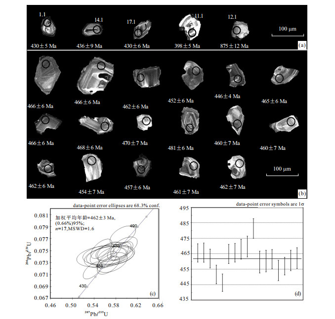
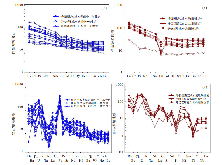
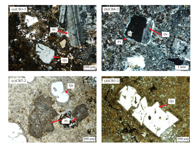
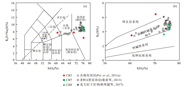
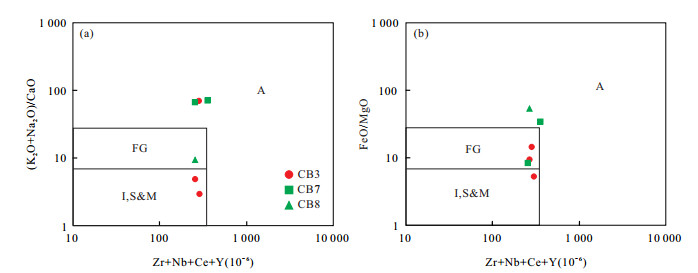
As the responses to the geological events on the southern margin of Central Asian Orogenic Belt in early Paleozoic, Ordovician volcanic rocks exposed in Ejin Banner, Inner Mongolia, offer important enlightenment for the evolution of Paleo-Asian Ocean. In this paper, the volcanic rocks and tuffs of Xianshuihu group and Baiyunshan group exposed in Hurengbasike area, Ejin Banner, are studied, including their petrology isotope chronology and geochemical characteristics such as major and trace elements. The results show that the lithology combination of Xianshuihu group is a series of basalt-basaltic andesite-andesite-rhyolite, as well as their volcanic lastic rocks, volcanic debris lava, while tuffs in baiyunshan group are mainly acidic. The volcanic rocks and tuffs belong to the sub-alkaline series, mainly showing the trends of calc-alkaline series evolution, and they are characterized by rich calcium and aluminum, poor magnesium, and larger TFeO/MgO ratios. Besides, the volcanic rocks have enriched LILE, LREE and depleted HFSE, with their REE distribution curves inclining to the right. Test results of SHRIMP zircon U-Pb isotope of the rhyolite sample from xianshuihu group yields a concordia age of 462±3 Ma(MSWD=1.6), indicating its formation era of late Ordovician, The tectonic setting of these volcanic rocks are different from the island arc volcanic rocks of Yihatuoli and Xirehada area in the west, belonging to the active continental margin, revealing the subduction of Zoolen Ocean in Mongolia towards the northern margin of Mingshui-Hanshan block during Middle Ordovician.
As the responses to the geological events on the southern margin of Central Asian Orogenic Belt in early Paleozoic, Ordovician volcanic rocks exposed in Ejin Banner, Inner Mongolia, offer important enlightenment for the evolution of Paleo-Asian Ocean. In this paper, the volcanic rocks and tuffs of Xianshuihu group and Baiyunshan group exposed in Hurengbasike area, Ejin Banner, are studied, including their petrology isotope chronology and geochemical characteristics such as major and trace elements. The results show that the lithology combination of Xianshuihu group is a series of basalt-basaltic andesite-andesite-rhyolite, as well as their volcanic lastic rocks, volcanic debris lava, while tuffs in baiyunshan group are mainly acidic. The volcanic rocks and tuffs belong to the sub-alkaline series, mainly showing the trends of calc-alkaline series evolution, and they are characterized by rich calcium and aluminum, poor magnesium, and larger TFeO/MgO ratios. Besides, the volcanic rocks have enriched LILE, LREE and depleted HFSE, with their REE distribution curves inclining to the right. Test results of SHRIMP zircon U-Pb isotope of the rhyolite sample from xianshuihu group yields a concordia age of 462±3 Ma(MSWD=1.6), indicating its formation era of late Ordovician, The tectonic setting of these volcanic rocks are different from the island arc volcanic rocks of Yihatuoli and Xirehada area in the west, belonging to the active continental margin, revealing the subduction of Zoolen Ocean in Mongolia towards the northern margin of Mingshui-Hanshan block during Middle Ordovician.


2020, 45(2): 519-533.
doi: 10.3799/dqkx.2018.309
Abstract:
LA-ICP-MS zircon U-Pb geochronology, whole-rock geochemistry and Hf isotope of zircons of Early Cretaceous Chibaisong granitoids in Tonghua area, southern Jilin Province, northeast (NE) China provide the insights into the nature of the lower crust and tectonic evolution of the eastern North China Craton (NCC). Zircons from the Chibaisong granitoid dyke (stock) show fine-scale oscillatory zoning, and relatively high Th/U ratios (0.53~1.94), indicative a magmatic origin. The weighted mean of 206Pb/238U ages for four samples from four granitoids are 116 Ma, 124 Ma, 127 Ma and 130 Ma, respectively. The Chibaisong granitoids have variable content of SiO2 (60.61%-76.07%) and MgO (0.01%-2.48%), high content of total-alkali (K2O+Na2O=6.26%-9.14%) and Al2O3 (11.99%-16.13%), characterized by the nature of high-K calc-alkaline series.Additionally, they show enrichment of LREEs and LILEs, depletion of HREEs and HFSEs, Ba, Sr, P, Ti and Eu (Eu/Eu*=0.05-0.30), suggesting that they were derived from the partial melting of the lower crust, and suffered from the fractional crystallization of plagioclase, alkali feldspar, apatite and ilmenite. Furthermore, they were assimilated by the country rock according to their variable major element contents and zircon εHf(t)values. Granitoids were more alkaline in the early stage of the Early Cretaceous and Mg# was increased, which may be attributed to mantle material. The zircon εHf(t) values in the samples ranged from -21.84 to -10.74, and the two-stage model ages of zircon Hf isotope of granite porphyry yield 1.86-2.56 Ga, which imply that the accretion of the lower crust within the Tonghua area mainly happened in the Paleoproterozoic, with small amounts during Neoproterozoic. The bimodal rock associationin the Early Cretaceous, together with the results from the contemporaneous volcanic rocks and regional evolution history in this area, indicate that the granitoid dykes may formed in an extensional setting, and more strongly extension happened during the late stage of Early Cretaceous associated with the subduction of the Paleo-Pacific Plate beneath the Eurasian continent.
LA-ICP-MS zircon U-Pb geochronology, whole-rock geochemistry and Hf isotope of zircons of Early Cretaceous Chibaisong granitoids in Tonghua area, southern Jilin Province, northeast (NE) China provide the insights into the nature of the lower crust and tectonic evolution of the eastern North China Craton (NCC). Zircons from the Chibaisong granitoid dyke (stock) show fine-scale oscillatory zoning, and relatively high Th/U ratios (0.53~1.94), indicative a magmatic origin. The weighted mean of 206Pb/238U ages for four samples from four granitoids are 116 Ma, 124 Ma, 127 Ma and 130 Ma, respectively. The Chibaisong granitoids have variable content of SiO2 (60.61%-76.07%) and MgO (0.01%-2.48%), high content of total-alkali (K2O+Na2O=6.26%-9.14%) and Al2O3 (11.99%-16.13%), characterized by the nature of high-K calc-alkaline series.Additionally, they show enrichment of LREEs and LILEs, depletion of HREEs and HFSEs, Ba, Sr, P, Ti and Eu (Eu/Eu*=0.05-0.30), suggesting that they were derived from the partial melting of the lower crust, and suffered from the fractional crystallization of plagioclase, alkali feldspar, apatite and ilmenite. Furthermore, they were assimilated by the country rock according to their variable major element contents and zircon εHf(t)values. Granitoids were more alkaline in the early stage of the Early Cretaceous and Mg# was increased, which may be attributed to mantle material. The zircon εHf(t) values in the samples ranged from -21.84 to -10.74, and the two-stage model ages of zircon Hf isotope of granite porphyry yield 1.86-2.56 Ga, which imply that the accretion of the lower crust within the Tonghua area mainly happened in the Paleoproterozoic, with small amounts during Neoproterozoic. The bimodal rock associationin the Early Cretaceous, together with the results from the contemporaneous volcanic rocks and regional evolution history in this area, indicate that the granitoid dykes may formed in an extensional setting, and more strongly extension happened during the late stage of Early Cretaceous associated with the subduction of the Paleo-Pacific Plate beneath the Eurasian continent.


2020, 45(2): 534-546.
doi: 10.3799/dqkx.2018.369
Abstract:
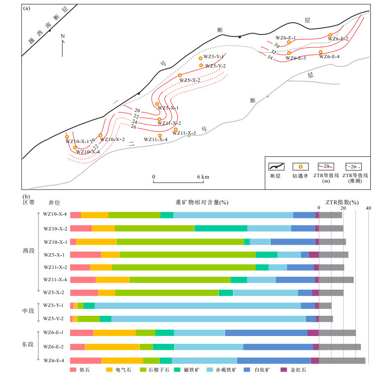
Using high quality 3D seismic data, combining analyses of light and heavy minerals, core observation and sand grain size distributions, sedimentary architecture and distribution features of steep slope fan in Upper Liushagang Formation of Weixi'nan Sag have been investigated in this study. These features vary along the NO.1 border fault:In the western part of steep slope belt, large-scale incised valleys developed, producing large-scale sub-lacustrine fans, which are characterized by thick beds of debris flow deposits; While in the middle part, small-scale channelized turbidite sub-lacustrine fans dominated; In eastern part, a series of small-scale symmetrical fans were located along the border fault, with sparse valleys present. Lateral variations of sediment supply, geomorphology and subsidence rate induced by multiple stages of border fault activity are considered the controlling factors:Fault slope in western part feeds coarser sediments from larger drainages. Meanwhile, large-scale incised valleys and complex morphology allow the growth of larger, asymmetrical fan lobes; On the other hand, fault slopes in the middle and eastern part with planar style and ramp-flat structure, respectively, provide a limited supply to multiple small fans.
Using high quality 3D seismic data, combining analyses of light and heavy minerals, core observation and sand grain size distributions, sedimentary architecture and distribution features of steep slope fan in Upper Liushagang Formation of Weixi'nan Sag have been investigated in this study. These features vary along the NO.1 border fault:In the western part of steep slope belt, large-scale incised valleys developed, producing large-scale sub-lacustrine fans, which are characterized by thick beds of debris flow deposits; While in the middle part, small-scale channelized turbidite sub-lacustrine fans dominated; In eastern part, a series of small-scale symmetrical fans were located along the border fault, with sparse valleys present. Lateral variations of sediment supply, geomorphology and subsidence rate induced by multiple stages of border fault activity are considered the controlling factors:Fault slope in western part feeds coarser sediments from larger drainages. Meanwhile, large-scale incised valleys and complex morphology allow the growth of larger, asymmetrical fan lobes; On the other hand, fault slopes in the middle and eastern part with planar style and ramp-flat structure, respectively, provide a limited supply to multiple small fans.


2020, 45(2): 547-558.
doi: 10.3799/dqkx.2018.359
Abstract:
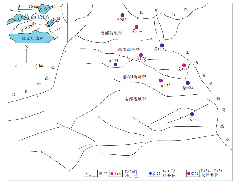
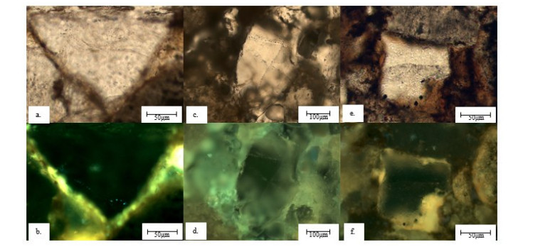
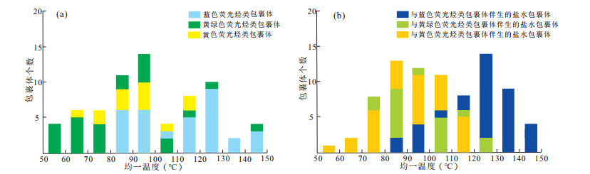
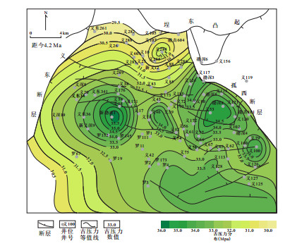
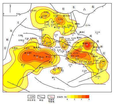
This study focuses on the characteristics of paleo-pressure gradient. Taking the Es3 in the Bonan sag as the research object,the paleo-pressure values of fluid inclusion uniform temperature and freezing point test technology were used as process control,and the basin simulation method was used to restore the pressure distribution characteristics during the reservoir period,on basis of which the paleo-pressure gradient of Es3z and Es3x in the Bonan sag were calculated,the distribution characteristics of the paleo-pressure gradient in the target stratum of the study area were revealed,and finally the relationship between paleopressure gradient and hydrocarbon containing was determined. The results show that the overpressure developed in the Bonan sag during the main hydrocarbon migration stage(4.2 Ma-now),paleo-pressure gradient of Es3x is higher than that of Es3z. As different structural zones,the high paleo-pressure gradient is often developed in the Bonan sag which is the active source area.The values of paleo-pressure gradient of Boshen 4 stepped belt and North steep slope are relatively gentle.The paleo-pressure gradient in South gentle slope is generally low. In the source area of the Es3x where the paleo-pressure gradient shows high hydrocarbon potential,and the Es3z where the hydrocarbon is distributed circularly around the center,this relationship is opposite. The high paleo-pressure gradient in the near source area represents a strong reservoir-forming power,and the hydrocarbon is distributed continuously.The relationship between the paleo-pressure gradient and the hydrocarbon potential in the far source area is weak.
This study focuses on the characteristics of paleo-pressure gradient. Taking the Es3 in the Bonan sag as the research object,the paleo-pressure values of fluid inclusion uniform temperature and freezing point test technology were used as process control,and the basin simulation method was used to restore the pressure distribution characteristics during the reservoir period,on basis of which the paleo-pressure gradient of Es3z and Es3x in the Bonan sag were calculated,the distribution characteristics of the paleo-pressure gradient in the target stratum of the study area were revealed,and finally the relationship between paleopressure gradient and hydrocarbon containing was determined. The results show that the overpressure developed in the Bonan sag during the main hydrocarbon migration stage(4.2 Ma-now),paleo-pressure gradient of Es3x is higher than that of Es3z. As different structural zones,the high paleo-pressure gradient is often developed in the Bonan sag which is the active source area.The values of paleo-pressure gradient of Boshen 4 stepped belt and North steep slope are relatively gentle.The paleo-pressure gradient in South gentle slope is generally low. In the source area of the Es3x where the paleo-pressure gradient shows high hydrocarbon potential,and the Es3z where the hydrocarbon is distributed circularly around the center,this relationship is opposite. The high paleo-pressure gradient in the near source area represents a strong reservoir-forming power,and the hydrocarbon is distributed continuously.The relationship between the paleo-pressure gradient and the hydrocarbon potential in the far source area is weak.


2020, 45(2): 559-568.
doi: 10.3799/dqkx.2019.003
Abstract:
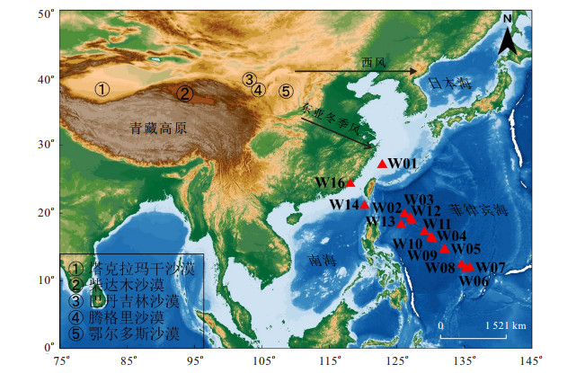
To discriminate the provenances and the transport mechanism of modern eolian sediments in the West Philippine Sea,mineral compositions as well as major and trace elements in the detrital phase of modern dust samples collected from the sea in the winter of 2015 were analyzed. Quartz,illite,plagioclase and gypsum are the most common detrital minerals,which are subangular and show obvious characteristics of aeolian deposits. The samples in our study show similar characteristics with the eolian dust from the Ordos Desert and the Badain Jaran Desert in the TiO2 versus Al2O3 diagram. Furthermore,the Zr-Th-Sc compositions of our samples display a binary mixing of the sediments from the Ordos Desert and the Taklimakan Desert. These results indicate that the Ordos Desert is the dominant source of the modern dust input to the Philippine Sea,whereas the contributions of the Taklimakan Desert and the Badain Jaran Desert are relatively small. In terms of the backward trajectory analysis,the modern eolian dust in the Philippine Sea is dominantly transported by the Eastern Asian Winter Monsoon.
To discriminate the provenances and the transport mechanism of modern eolian sediments in the West Philippine Sea,mineral compositions as well as major and trace elements in the detrital phase of modern dust samples collected from the sea in the winter of 2015 were analyzed. Quartz,illite,plagioclase and gypsum are the most common detrital minerals,which are subangular and show obvious characteristics of aeolian deposits. The samples in our study show similar characteristics with the eolian dust from the Ordos Desert and the Badain Jaran Desert in the TiO2 versus Al2O3 diagram. Furthermore,the Zr-Th-Sc compositions of our samples display a binary mixing of the sediments from the Ordos Desert and the Taklimakan Desert. These results indicate that the Ordos Desert is the dominant source of the modern dust input to the Philippine Sea,whereas the contributions of the Taklimakan Desert and the Badain Jaran Desert are relatively small. In terms of the backward trajectory analysis,the modern eolian dust in the Philippine Sea is dominantly transported by the Eastern Asian Winter Monsoon.

2020, 45(2): 569-582.
doi: 10.3799/dqkx.2018.247
Abstract:
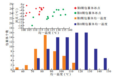
Although the method of homogenization temperature (Th) of fluid inclusion projecting on burial history diagram with thermal curve to obtain hydrocarbon charging times has been widely and effectively used,some uncertainty arises on the multi-cycle superimposed basins,in which one Th can appear at two or more than two depths. For the purpose of reducing the multiple solutions,63 samples of the Ordovician in Yubei area have been employed to make diagenetic observation,carbon and oxygen isotope analyses,and fluid inclusions analyses. Diagenetic sequence and two parameters of Th and trapping pressure (Pt) have been utilized to doubly constrain the times of hydrocarbon charging. When the Th of oil inclusion and its coeval aqueous inclusion,gas to liquid ratio of oil inclusion and chemical components of oil inclusion are obtained,the trapping pressure of the oil inclusion can be thermodynamically modeled by the software PVTsim. After the Pt of oil inclusion and the Th of its coeval aqueous inclusion were projected doubly on burial history diagram for each well,the hydrocarbon charging time would be determined. Then,we put all the charging times on the same geological age axis,three events of hydrocarbon charging occurred in the Ordovician of Yubei area,Tarim basin:the first event took place from 447.1 Ma to 444.0 Ma (during the Late Caledonian); the secondary event from 295.0 Ma to 274.7 Ma (during the Late Hercynian); the tertiary event from 14.7 Ma to 8.8 Ma (during the Late Himalaya). The oil pools charged by the first and the secondary event were destroyed or adjusted in the process of tectonic movement,and the oil pools charged by the tertiary event maybe the favorable exploration target.
Although the method of homogenization temperature (Th) of fluid inclusion projecting on burial history diagram with thermal curve to obtain hydrocarbon charging times has been widely and effectively used,some uncertainty arises on the multi-cycle superimposed basins,in which one Th can appear at two or more than two depths. For the purpose of reducing the multiple solutions,63 samples of the Ordovician in Yubei area have been employed to make diagenetic observation,carbon and oxygen isotope analyses,and fluid inclusions analyses. Diagenetic sequence and two parameters of Th and trapping pressure (Pt) have been utilized to doubly constrain the times of hydrocarbon charging. When the Th of oil inclusion and its coeval aqueous inclusion,gas to liquid ratio of oil inclusion and chemical components of oil inclusion are obtained,the trapping pressure of the oil inclusion can be thermodynamically modeled by the software PVTsim. After the Pt of oil inclusion and the Th of its coeval aqueous inclusion were projected doubly on burial history diagram for each well,the hydrocarbon charging time would be determined. Then,we put all the charging times on the same geological age axis,three events of hydrocarbon charging occurred in the Ordovician of Yubei area,Tarim basin:the first event took place from 447.1 Ma to 444.0 Ma (during the Late Caledonian); the secondary event from 295.0 Ma to 274.7 Ma (during the Late Hercynian); the tertiary event from 14.7 Ma to 8.8 Ma (during the Late Himalaya). The oil pools charged by the first and the secondary event were destroyed or adjusted in the process of tectonic movement,and the oil pools charged by the tertiary event maybe the favorable exploration target.


2020, 45(2): 583-601.
doi: 10.3799/dqkx.2019.004
Abstract:
In order to quantify the characteristics of hydrocarbon generation and expulsion of Mesozoic main source rocks in the eastern depression of the North Yellow Sea Basin,geochemicalcharacteristic of the Mesozoic source rocks in this study area was summarized by comprehensively using vitrinite reflectance (Ro),residual organic carbon (TOC),rock pyrolysis,kerogen microscopic examination and gas chromatographic analysis of saturated hydrocarbons and other geological data. Then on the base of these,this paper has clearly defined the chief source rocks through oil-source correlation and furtherquantified the contribution of hydrocarbongeneration and expulsion. The results show that two types of Mesozoic crude oil in eastern depression of the North Yellow Sea Basin are all originated from the two chief source rocks of the Middle Jurassic and Upper Jurassic. Among them,organic matter abundance of the Middle Jurassic source rocks is in the "good-best" level,while that of the Upper Jurassic source rocks is mainly in the "medium-good" level.The two sets of source rocks all have two peaks of hydrocarbon generation and expulsion in the Early Cretaceous and Early Miocene. However,the hydrocarbon-expulsion rate of the Upper Jurassic source rocks[qe(max)=27.3×10⁶ t/Ma] is much higher than that of the Middle Jurassic source rocks[qe(max)=4.2×10⁶ t/Ma],which has the most important contribution to the hydrocarbon accumulation. Although the hydrocarbon generation potential of dark mudstones in the Lower Cretaceous is limited,the source-reservoir matching relationship between the bottom sandstone of the Lower Cretaceous and the chief source rocks of the Upper Jurassic is "lower generation and upperaccumulation",which is the first exploration target in this study area. The secondary target layer is the reservoir forming combination of "self generation and self accumulation" in the Middle and Upper Jurassic. And the reservoir combination of "upper generation and lower accumulation" in the lower part of the Middle Jurassicis also noteworthy in oil-gas exploration.
In order to quantify the characteristics of hydrocarbon generation and expulsion of Mesozoic main source rocks in the eastern depression of the North Yellow Sea Basin,geochemicalcharacteristic of the Mesozoic source rocks in this study area was summarized by comprehensively using vitrinite reflectance (Ro),residual organic carbon (TOC),rock pyrolysis,kerogen microscopic examination and gas chromatographic analysis of saturated hydrocarbons and other geological data. Then on the base of these,this paper has clearly defined the chief source rocks through oil-source correlation and furtherquantified the contribution of hydrocarbongeneration and expulsion. The results show that two types of Mesozoic crude oil in eastern depression of the North Yellow Sea Basin are all originated from the two chief source rocks of the Middle Jurassic and Upper Jurassic. Among them,organic matter abundance of the Middle Jurassic source rocks is in the "good-best" level,while that of the Upper Jurassic source rocks is mainly in the "medium-good" level.The two sets of source rocks all have two peaks of hydrocarbon generation and expulsion in the Early Cretaceous and Early Miocene. However,the hydrocarbon-expulsion rate of the Upper Jurassic source rocks[qe(max)=27.3×10⁶ t/Ma] is much higher than that of the Middle Jurassic source rocks[qe(max)=4.2×10⁶ t/Ma],which has the most important contribution to the hydrocarbon accumulation. Although the hydrocarbon generation potential of dark mudstones in the Lower Cretaceous is limited,the source-reservoir matching relationship between the bottom sandstone of the Lower Cretaceous and the chief source rocks of the Upper Jurassic is "lower generation and upperaccumulation",which is the first exploration target in this study area. The secondary target layer is the reservoir forming combination of "self generation and self accumulation" in the Middle and Upper Jurassic. And the reservoir combination of "upper generation and lower accumulation" in the lower part of the Middle Jurassicis also noteworthy in oil-gas exploration.


2020, 45(2): 602-616.
doi: 10.3799/dqkx.2019.220
Abstract:
The analyses of X-ray powder diffraction,porosity and permeability,high pressure mercury,nitrogen adsorption,Micro-CT scanning,and FIB-SEM were performed,aiming to understand the pore structure characteristics of the shale reservoir and discuss the controlling factors of the superiority of rock physical property of of different lithologies of the 14th cyclotherm of the Lower Qian4 Member in the Wangchang anticline of the Qianjiang sag. Studies show that the reservoir consists mainly of dolomite (40.5% on average),calcite (10.4% on average),feldspar (16.5% on average),clay minerals (11.2% on average),anhydrite (10.8% on average),and quartz (5.9% on average); the rock is "high-medium porosity (average 17.6%) and very low permeability (average 0.043 6 mD)" type; high macropore rate (79.7% on average) within each lithology (except argillaceous limestone) contributes to excellent porosity,and the correlation between dolomite and calcite content and macopore and micropore rate indicates that dolomitization is closely related to the formation of macropore. Dolomiticzation along with calcite precipiatation lays the foundation of poor permeability,and the positive correlation between anhydrite content and geometrical tortuosity indicates the enhancement of the space complexity of the pore throat and the deterioration of permeability. The less connecting number (main peak at 3) and the low efficiency of mercury withdrawal (40% on average) reflect poor connectivity which also has a certain effect on permeability.
The analyses of X-ray powder diffraction,porosity and permeability,high pressure mercury,nitrogen adsorption,Micro-CT scanning,and FIB-SEM were performed,aiming to understand the pore structure characteristics of the shale reservoir and discuss the controlling factors of the superiority of rock physical property of of different lithologies of the 14th cyclotherm of the Lower Qian4 Member in the Wangchang anticline of the Qianjiang sag. Studies show that the reservoir consists mainly of dolomite (40.5% on average),calcite (10.4% on average),feldspar (16.5% on average),clay minerals (11.2% on average),anhydrite (10.8% on average),and quartz (5.9% on average); the rock is "high-medium porosity (average 17.6%) and very low permeability (average 0.043 6 mD)" type; high macropore rate (79.7% on average) within each lithology (except argillaceous limestone) contributes to excellent porosity,and the correlation between dolomite and calcite content and macopore and micropore rate indicates that dolomitization is closely related to the formation of macropore. Dolomiticzation along with calcite precipiatation lays the foundation of poor permeability,and the positive correlation between anhydrite content and geometrical tortuosity indicates the enhancement of the space complexity of the pore throat and the deterioration of permeability. The less connecting number (main peak at 3) and the low efficiency of mercury withdrawal (40% on average) reflect poor connectivity which also has a certain effect on permeability.


2020, 45(2): 617-633.
doi: 10.3799/dqkx.2019.008
Abstract:
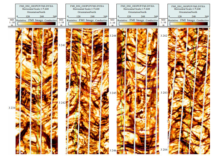
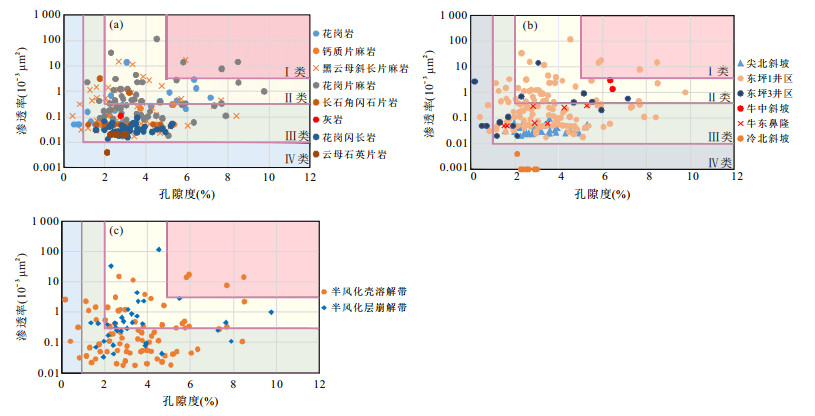
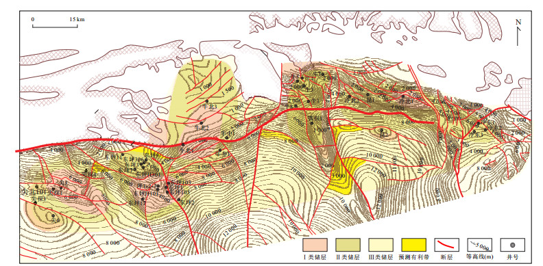
Based on the field outcrop survey,core observation,section identification,scanning electron microscopy and cathodoluminescence method,combined with conventional logging,image logging,pore infiltration test data,etc.,main characteristics and evaluation of bedrock reservoirs in the eastern segment of the Altun Piedmont were studied. The results show that the lithology of the bedrock reservoirs in the eastern segment of Altun Piedmont mainly includes magmatic rocks and metamorphic rocks. The magmatic rocks are mainly granite,and the metamorphic rocks are mainly gneiss and schist. The types of reservoir space mainly include incompletely filled fractures,dissolved pores and matrix micropores. The maximum porosity of bedrock reservoir is 9.76%,the minimum is 0.004%,and the average is 1.663%~3.844%. The maximum permeability of bedrock reservoir is 33.239 mD,the minimum is 0.002 mD,and the average permeability is 0.020~3.836 mD. There is no obvious correlation between porosity and permeability. The main controlling factors of bedrock reservoirs include lithology and mineral combination,paleogeomorphology,pre-existing faults and fracture zones,late magmatic intrusion and hydrothermal action. Combined with the physical properties and the main controlling factors of the bedrock reservoir,the evaluation criteria of bedrock reservoir controlled by many factors are put forward. The reservoir is divided into four categories:good,average,fair,and poor. The results of evaluation show that the study area is mainly composed of type Ⅱ reservoirs,mainly found in granitic gneiss,followed by granite,plagioclase gneiss,feldspar hornblende schist,etc. The Dongping nasal and Niuzhong-Niubei slopes are mostly type Ⅰ reservoirs,the Jianbei slope,Niudong nasal and Lengbei slope are mostly type Ⅱ reservoirs.
Based on the field outcrop survey,core observation,section identification,scanning electron microscopy and cathodoluminescence method,combined with conventional logging,image logging,pore infiltration test data,etc.,main characteristics and evaluation of bedrock reservoirs in the eastern segment of the Altun Piedmont were studied. The results show that the lithology of the bedrock reservoirs in the eastern segment of Altun Piedmont mainly includes magmatic rocks and metamorphic rocks. The magmatic rocks are mainly granite,and the metamorphic rocks are mainly gneiss and schist. The types of reservoir space mainly include incompletely filled fractures,dissolved pores and matrix micropores. The maximum porosity of bedrock reservoir is 9.76%,the minimum is 0.004%,and the average is 1.663%~3.844%. The maximum permeability of bedrock reservoir is 33.239 mD,the minimum is 0.002 mD,and the average permeability is 0.020~3.836 mD. There is no obvious correlation between porosity and permeability. The main controlling factors of bedrock reservoirs include lithology and mineral combination,paleogeomorphology,pre-existing faults and fracture zones,late magmatic intrusion and hydrothermal action. Combined with the physical properties and the main controlling factors of the bedrock reservoir,the evaluation criteria of bedrock reservoir controlled by many factors are put forward. The reservoir is divided into four categories:good,average,fair,and poor. The results of evaluation show that the study area is mainly composed of type Ⅱ reservoirs,mainly found in granitic gneiss,followed by granite,plagioclase gneiss,feldspar hornblende schist,etc. The Dongping nasal and Niuzhong-Niubei slopes are mostly type Ⅰ reservoirs,the Jianbei slope,Niudong nasal and Lengbei slope are mostly type Ⅱ reservoirs.


2020, 45(2): 634-644.
doi: 10.3799/dqkx.2018.384
Abstract:
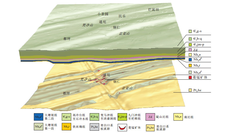
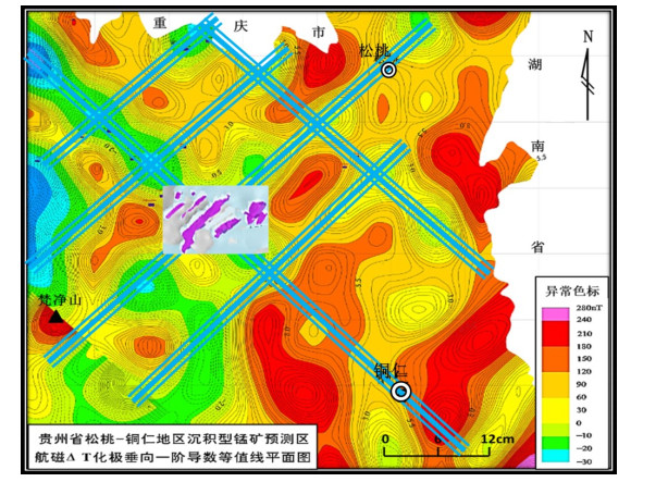
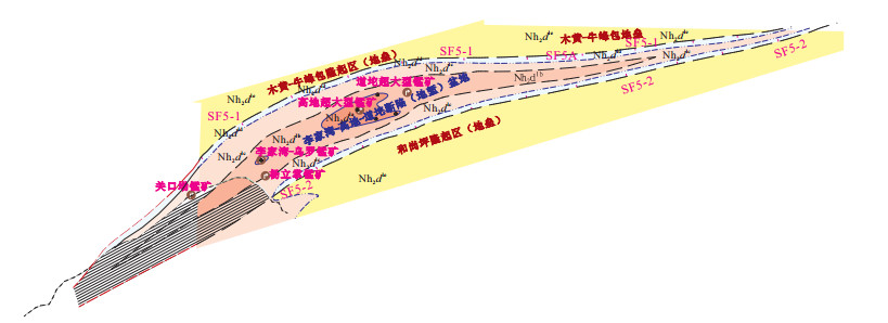
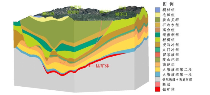
The "Datangpo type" manganese deposit which is adjacent to Guizhou, Hunan and Chongqing has unique metallogenic environment and mechanism in the world. It can be directly and vividly researched by means of three-dimensional geological modeling and visualization. Based on the systematic analysis and processing of superlarge manganese ore field from Songtao County in Guizhou, with regional relevant materials, QuantyMine 3D mining software was utilized. Accordingly, three 3D geological models of different scales such as the Wuling secondary rift basin prototype during early Nanhua which is adjacent to Guizhou, Hunan and Chongqing, the manganese ore field due to ancient natural gas leakage and sedimentary and the typical manganese deposit in Datangpo of Songtao County were constructed respectively. Moreover, the unique metallogenic environment of superlarge manganese deposit was scientifically expressed, the ore-forming mechanism and the occurrence status were revealed apparently. As a consequence, novel approaches for this type of metallogenic research and ore-forming prediction were proposed.
The "Datangpo type" manganese deposit which is adjacent to Guizhou, Hunan and Chongqing has unique metallogenic environment and mechanism in the world. It can be directly and vividly researched by means of three-dimensional geological modeling and visualization. Based on the systematic analysis and processing of superlarge manganese ore field from Songtao County in Guizhou, with regional relevant materials, QuantyMine 3D mining software was utilized. Accordingly, three 3D geological models of different scales such as the Wuling secondary rift basin prototype during early Nanhua which is adjacent to Guizhou, Hunan and Chongqing, the manganese ore field due to ancient natural gas leakage and sedimentary and the typical manganese deposit in Datangpo of Songtao County were constructed respectively. Moreover, the unique metallogenic environment of superlarge manganese deposit was scientifically expressed, the ore-forming mechanism and the occurrence status were revealed apparently. As a consequence, novel approaches for this type of metallogenic research and ore-forming prediction were proposed.


2020, 45(2): 645-662.
doi: 10.3799/dqkx.2019.012
Abstract:
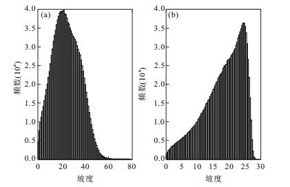
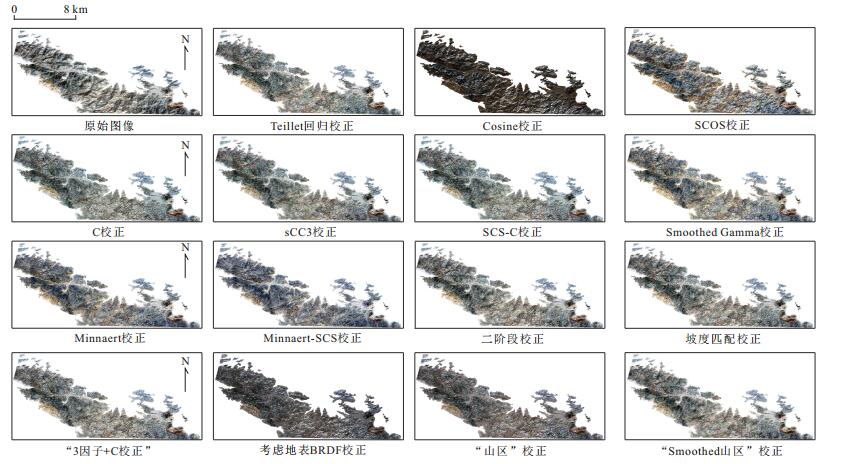
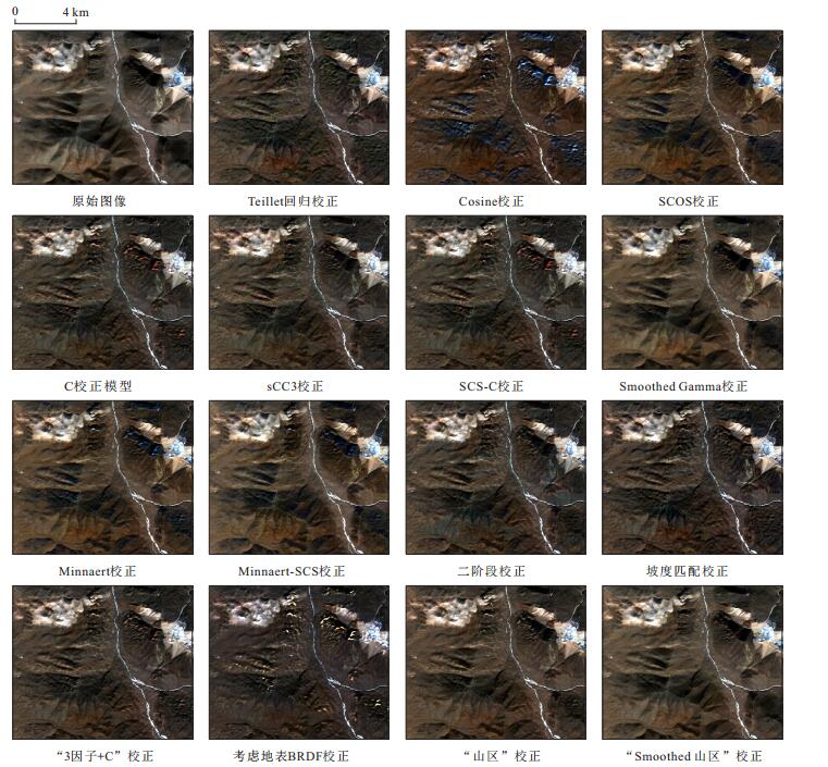
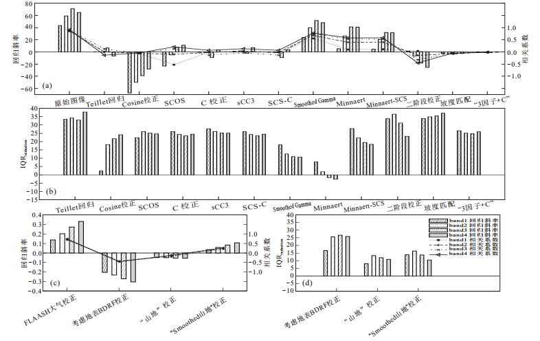
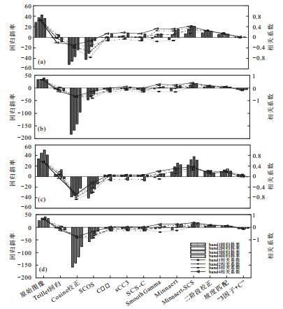
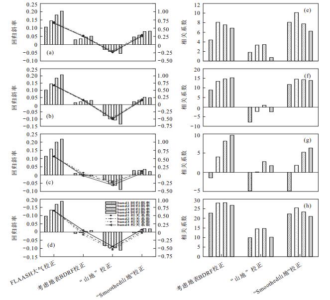
With complex terrain and steep slopes, sharp orographic effect occurs in mountainous areas which obviously increases the difficulty of remote sensing geological mapping by the phenomenon of "different bodies with same spectrums" or "same body with different spectrums". Although several Topographic correction (TOC) methods have been proposed and applied to vegetationcovered area and snowfield successfully in the last decades, there is little discussion on topographic correction models for geological mapping under complex topographic conditions, which have totally different application environment since the uncovered geological bodies of mountainous areas have bigger spatial variability. Especially in the correction of high spatial resolution remote sensing images, the corresponding high-precision Digital Elevation Model (DEM) is often absent, and the correction results are vulnerable to topographic anomalies. This paper proposes a "Smoothed Mountains" correction method, which combines Richter "Mountains" correction model with terrain smoothing model. GF-1, GF-2 and SPOT6 mountain images obtained by this model have been compared with those by other 14 terrain correction models. The results show that the stability and correction effect of the "Smoothed Mountains" correction model are obviously better than other models. The correction images show that the terrain effect is weakened, and the image information is rich and undistorted. Moreover, the surface reflectance data can be obtained directly, which provides basic data for further remote sensing alteration extraction. Therefore, the "Smoothed Mountains" model could be a practical and feasible TOC model in remote sensing geological mapping over steep mountain terrain.
With complex terrain and steep slopes, sharp orographic effect occurs in mountainous areas which obviously increases the difficulty of remote sensing geological mapping by the phenomenon of "different bodies with same spectrums" or "same body with different spectrums". Although several Topographic correction (TOC) methods have been proposed and applied to vegetationcovered area and snowfield successfully in the last decades, there is little discussion on topographic correction models for geological mapping under complex topographic conditions, which have totally different application environment since the uncovered geological bodies of mountainous areas have bigger spatial variability. Especially in the correction of high spatial resolution remote sensing images, the corresponding high-precision Digital Elevation Model (DEM) is often absent, and the correction results are vulnerable to topographic anomalies. This paper proposes a "Smoothed Mountains" correction method, which combines Richter "Mountains" correction model with terrain smoothing model. GF-1, GF-2 and SPOT6 mountain images obtained by this model have been compared with those by other 14 terrain correction models. The results show that the stability and correction effect of the "Smoothed Mountains" correction model are obviously better than other models. The correction images show that the terrain effect is weakened, and the image information is rich and undistorted. Moreover, the surface reflectance data can be obtained directly, which provides basic data for further remote sensing alteration extraction. Therefore, the "Smoothed Mountains" model could be a practical and feasible TOC model in remote sensing geological mapping over steep mountain terrain.


2020, 45(2): 663-671.
doi: 10.3799/dqkx.2018.398
Abstract:
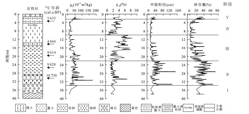
The middle reaches of the Yangtze River are the most severely affected areas in China, and the Wuhan section is the key to flood control in the middle reaches of Yangtze River. It is of great significance to study the paleoflood of the Yangtze River in Wuhan area so as to prolong the record of the paleoflood. In this study, ZK145 borehole was selected in a typical lake behind the dam of Wuhan section of the Yangtze River. Based on the analysis of sedimentary lithology and sedimentary facies, magnetic characteristics and particle size characteristics of the core were analyzed, and AMS14C dating was used to study the occurrence period of holocene paleoflood in wuhan section of the Yangtze River. The borehole is divided into five sedimentary stages based on the mass magnetic susceptibility(χ) and the frequency susceptibility (χfd%) curve.Combined with the median particle size and sand content, nine paleoflood events were identified, with the age:10 580-10 510, 10 280-10 200, 9 690-9 670, 9 530-9 500, 8 660-8 450, 7 700-7 500, 6 270-5 910, 4 850-4 800, 3 560-3 500 cal.a BP, paleofloods occurred frequently at 9 700-4 800 cal.a BP among them. Through analysis of temperature-dependent magnetic susceptibility (κ-T curve), the heating curve of the paleoflood sediments shows a more obvious peak near 510℃ in paleoflood sediments, and Magnetite is the dominant magnetic mineral. The research shows that the high mass magnetic susceptibility, the low frequency susceptibility and the coarser particle size are the identification marks of the paleoflood deposition in the lakes behind the Yangtze River embankment in the Yangtze River.
The middle reaches of the Yangtze River are the most severely affected areas in China, and the Wuhan section is the key to flood control in the middle reaches of Yangtze River. It is of great significance to study the paleoflood of the Yangtze River in Wuhan area so as to prolong the record of the paleoflood. In this study, ZK145 borehole was selected in a typical lake behind the dam of Wuhan section of the Yangtze River. Based on the analysis of sedimentary lithology and sedimentary facies, magnetic characteristics and particle size characteristics of the core were analyzed, and AMS14C dating was used to study the occurrence period of holocene paleoflood in wuhan section of the Yangtze River. The borehole is divided into five sedimentary stages based on the mass magnetic susceptibility(χ) and the frequency susceptibility (χfd%) curve.Combined with the median particle size and sand content, nine paleoflood events were identified, with the age:10 580-10 510, 10 280-10 200, 9 690-9 670, 9 530-9 500, 8 660-8 450, 7 700-7 500, 6 270-5 910, 4 850-4 800, 3 560-3 500 cal.a BP, paleofloods occurred frequently at 9 700-4 800 cal.a BP among them. Through analysis of temperature-dependent magnetic susceptibility (κ-T curve), the heating curve of the paleoflood sediments shows a more obvious peak near 510℃ in paleoflood sediments, and Magnetite is the dominant magnetic mineral. The research shows that the high mass magnetic susceptibility, the low frequency susceptibility and the coarser particle size are the identification marks of the paleoflood deposition in the lakes behind the Yangtze River embankment in the Yangtze River.


2020, 45(2): 672-684.
doi: 10.3799/dqkx.2019.005
Abstract:
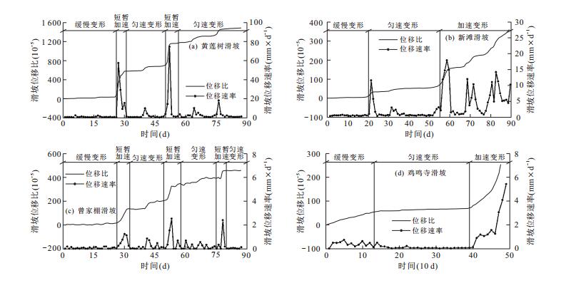
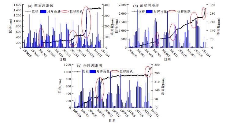
Establishing the efficient and reasonable regional landslide hazards rainfall warning model plays an important role in landslide prevention. However, more previous studies have been focused on the early warning before sliding rather than on the temporary accelerated deformation of creeping landslide after the heavy rainfall. Taking landslides in Yunyang County of the Three Gorges Reservoir region as an example, statistical samples were selected reasonably according to the characteristics of the landslide surface displacement monitoring data firstly. Then the rainfall statistical variable applied to different time periods was determined by correlation analysis between rainfall index and landslide occurrence, and numerical simulation of displacement change of landslides in the rainfall condition. The displacement ratio (ratio of cumulative displacement and length of landslide) considering the scale characteristic of landslide was selected as the landslide deformation index and monitoring data of landslides and historical rainfall information in different time periods were counted. The relationship between daily rainfall data and monthly displacement data was built up. The displacement ratio model which can determine the rainfall thresholds was obtained, and fivelevel warning partition of creeping landslides in Yunyang County was determined. Finally, landslide instances, long-time displacement monitoring data and extreme rainfall event in research area were used to test the warning results of this model, respectively. The results show that the warning results of this model based on monitoring system data were the same as real conditions, and it could provide the basis for the early warning and prediction of the creeping landslides.
Establishing the efficient and reasonable regional landslide hazards rainfall warning model plays an important role in landslide prevention. However, more previous studies have been focused on the early warning before sliding rather than on the temporary accelerated deformation of creeping landslide after the heavy rainfall. Taking landslides in Yunyang County of the Three Gorges Reservoir region as an example, statistical samples were selected reasonably according to the characteristics of the landslide surface displacement monitoring data firstly. Then the rainfall statistical variable applied to different time periods was determined by correlation analysis between rainfall index and landslide occurrence, and numerical simulation of displacement change of landslides in the rainfall condition. The displacement ratio (ratio of cumulative displacement and length of landslide) considering the scale characteristic of landslide was selected as the landslide deformation index and monitoring data of landslides and historical rainfall information in different time periods were counted. The relationship between daily rainfall data and monthly displacement data was built up. The displacement ratio model which can determine the rainfall thresholds was obtained, and fivelevel warning partition of creeping landslides in Yunyang County was determined. Finally, landslide instances, long-time displacement monitoring data and extreme rainfall event in research area were used to test the warning results of this model, respectively. The results show that the warning results of this model based on monitoring system data were the same as real conditions, and it could provide the basis for the early warning and prediction of the creeping landslides.


2020, 45(2): 685-692.
doi: 10.3799/dqkx.2018.366
Abstract:
Single Well Injection-Withdraw (SWIW) test has been widely used to estimate physical and chemical parameters of aquifer due to its advantages of low budget, less time consuming and easy to operate. However, the complex flow fields near the wellbore pose challenges in solving the model of the SWIW test, especially for partially penetrating wells. Currently, three methods included in MODFLOW/MT3DMSwere used to deal with this problem:traditional WELL module, high permeability WELL module and MNW module, which respectively represent three types of commonly used numerical methods. However, it was found that all of these models were based on assumptions which might not be satisfied in the actual applications. In this study, a new method was developed by coupling the MNW module and high permeability WELL module. The case studies demonstrated the accuracy of the new model of the SWIW test. Meanwhile, we employed the new model to investigate two assumptions included in the previous studies, and found that:(1) the influence of the well screen location on the results was not negligible. (2) The assumption of the steady-flow field used in the traditional mathematical model of SWIW will cause non-negligible errors when the ratio of permeability coefficient to storage coefficient is small.
Single Well Injection-Withdraw (SWIW) test has been widely used to estimate physical and chemical parameters of aquifer due to its advantages of low budget, less time consuming and easy to operate. However, the complex flow fields near the wellbore pose challenges in solving the model of the SWIW test, especially for partially penetrating wells. Currently, three methods included in MODFLOW/MT3DMSwere used to deal with this problem:traditional WELL module, high permeability WELL module and MNW module, which respectively represent three types of commonly used numerical methods. However, it was found that all of these models were based on assumptions which might not be satisfied in the actual applications. In this study, a new method was developed by coupling the MNW module and high permeability WELL module. The case studies demonstrated the accuracy of the new model of the SWIW test. Meanwhile, we employed the new model to investigate two assumptions included in the previous studies, and found that:(1) the influence of the well screen location on the results was not negligible. (2) The assumption of the steady-flow field used in the traditional mathematical model of SWIW will cause non-negligible errors when the ratio of permeability coefficient to storage coefficient is small.


2020, 45(2): 693-700.
doi: 10.3799/dqkx.2018.345
Abstract:
In this study, a mathematical model with the intersection angle between the flow direction and the x axial direction of 45degree was developed to investigate the effect of non-Darcy parameter n on flow field and solute migration when flow is oblique crossing the fracture. The Comsol Multiphysics software was used to do such numerical simulation. The simulation area was assumed to be square with a horizontal fracture embedded in the middle.The flow in the fracture was assumed to be non-Darcian and can be described by the Izbash equation. A constant solute source has been assigned in the upper matrix. The results indicate the following phenomena as the power index in the Izbash equation(n) increases:(1) the fracture flow velocity increases, and the flow line at the matrix-fracture interfaces gradually deviates from the classical fraction law; (2) the flow direction in fracture gradually turns to the direction in the matrix; (3) the width of solute plume increases, while the symmetry of solute plume reduces; (4) the peak solute concentration in the horizontal section diminishes, and the solute concentration on the right sight of the model increases; (5) the effect of back dispersion caused by fracture on solute plume becomes stronger, which results in more solutes in the fracture migrated to the upper matrix. Overall, the non-Darcy flow fracture has a significant impact on the flow field and solute distribution.
In this study, a mathematical model with the intersection angle between the flow direction and the x axial direction of 45degree was developed to investigate the effect of non-Darcy parameter n on flow field and solute migration when flow is oblique crossing the fracture. The Comsol Multiphysics software was used to do such numerical simulation. The simulation area was assumed to be square with a horizontal fracture embedded in the middle.The flow in the fracture was assumed to be non-Darcian and can be described by the Izbash equation. A constant solute source has been assigned in the upper matrix. The results indicate the following phenomena as the power index in the Izbash equation(n) increases:(1) the fracture flow velocity increases, and the flow line at the matrix-fracture interfaces gradually deviates from the classical fraction law; (2) the flow direction in fracture gradually turns to the direction in the matrix; (3) the width of solute plume increases, while the symmetry of solute plume reduces; (4) the peak solute concentration in the horizontal section diminishes, and the solute concentration on the right sight of the model increases; (5) the effect of back dispersion caused by fracture on solute plume becomes stronger, which results in more solutes in the fracture migrated to the upper matrix. Overall, the non-Darcy flow fracture has a significant impact on the flow field and solute distribution.

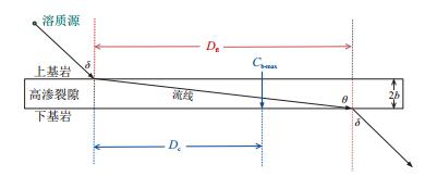
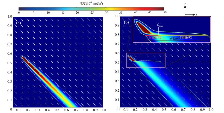


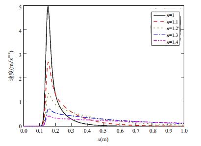

2020, 45(2): 701-710.
doi: 10.3799/dqkx.2018.363
Abstract:
With the increasing demand of groundwater and the continuous deterioration of water quality in Jianghan plain, it is of great significance to deeply explore the causes of groundwater for rational utilization and evaluation of groundwater. Taking YLW01 in central region and HJ007 near Hanjiang river as the study objects, porewater samples were squeezed from the drilled undisturbed soil columns to analyze hydrochemical characteristics and hydrogen and oxygen isotopic characteristics. The results show that:YLW01 porewater samples of sandy soil in middle-deep depth were saline water and the total dissolved solids (TDS) ranged from 1 131 to 4 013 mg/L, while other porewater samples of clay were fresh water; HJ007 porewater samples were all fresh water. The high concentration of SO42- (459~2 124 mg/L) of YLW01 porewater in middle-deep depth sandy soil was caused by Gypsum dissolution; the high concentration of NO3- (22~315 mg/L) of HJ007 porewater in middle-deep depth was caused by nitrification in soil. The chemical composition of porewater was mainly affected by mineral dissolution and cation exchange, and the degree of action in the Yangtze and Hanjiang River zone was different. Hydrogen and oxygen isotopic characteristics indicated that porewater came from atmospheric precipitation and the shallow groundwater in Hanjiang River zone was obviously mixed with surface water. The differences in chemical and isotopic concentrations of the two boreholes in Jianghan Plain were controlled by the sedimentary environment, sediment particle size and mineral composition of the Yangtze and Hanjiang River effecting zones.
With the increasing demand of groundwater and the continuous deterioration of water quality in Jianghan plain, it is of great significance to deeply explore the causes of groundwater for rational utilization and evaluation of groundwater. Taking YLW01 in central region and HJ007 near Hanjiang river as the study objects, porewater samples were squeezed from the drilled undisturbed soil columns to analyze hydrochemical characteristics and hydrogen and oxygen isotopic characteristics. The results show that:YLW01 porewater samples of sandy soil in middle-deep depth were saline water and the total dissolved solids (TDS) ranged from 1 131 to 4 013 mg/L, while other porewater samples of clay were fresh water; HJ007 porewater samples were all fresh water. The high concentration of SO42- (459~2 124 mg/L) of YLW01 porewater in middle-deep depth sandy soil was caused by Gypsum dissolution; the high concentration of NO3- (22~315 mg/L) of HJ007 porewater in middle-deep depth was caused by nitrification in soil. The chemical composition of porewater was mainly affected by mineral dissolution and cation exchange, and the degree of action in the Yangtze and Hanjiang River zone was different. Hydrogen and oxygen isotopic characteristics indicated that porewater came from atmospheric precipitation and the shallow groundwater in Hanjiang River zone was obviously mixed with surface water. The differences in chemical and isotopic concentrations of the two boreholes in Jianghan Plain were controlled by the sedimentary environment, sediment particle size and mineral composition of the Yangtze and Hanjiang River effecting zones.