2020 Vol. 45, No. 7
Display Method:
 PDF 328KB
2020, 45(7): 2245-2257.
doi: 10.3799/dqkx.2020.160
Abstract:
The nature of the Tibetan extremely thick crust and its thickening mechanism are important scientific problems. According to the investigation of igneous rocks,especially Nd and Hf isotope studies,it proved the coexistence of two types of crust (juvenile and reworked) in the Tibetan Plateau,which controls the distribution of different types of ore deposits. The Tibetan crustal thickening was made by both tectonic compression and the input of mantle components carried by magmatism. The timing of the Tibetan crustal thickening was likely in the period of 50-25 Ma.Continental collision zones may be sites of net crustal growth through process of syncollisional magmatism.
The nature of the Tibetan extremely thick crust and its thickening mechanism are important scientific problems. According to the investigation of igneous rocks,especially Nd and Hf isotope studies,it proved the coexistence of two types of crust (juvenile and reworked) in the Tibetan Plateau,which controls the distribution of different types of ore deposits. The Tibetan crustal thickening was made by both tectonic compression and the input of mantle components carried by magmatism. The timing of the Tibetan crustal thickening was likely in the period of 50-25 Ma.Continental collision zones may be sites of net crustal growth through process of syncollisional magmatism.


2020, 45(7): 2258-2278.
doi: 10.3799/dqkx.2020.191
Abstract:
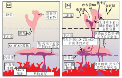
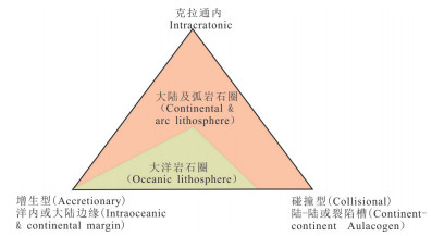
This paper proposed that the world's largest Bayan Obo rare earth elements (REE) deposit is controlled by the geological evolution of the oceanic plate which subducted from the Asian Ocean towards the northern margin of the North China Carton (NCC). And discussed the geological tectonic development of the Asian Ocean plate in the Bayan-Obo region,and the Neoproterozoic,Early and Late Paleozoic subduction-accretionary complex developed successively during the subduction of the Asian Ocean to the northern margin of the NCC. The origin of the Bayan Obo REE deposit is also discussed. It is believed that the REE-riched carbonatite magma is produced in the so-called special far backarc settings in the northern margin of NCC,which some people call it as far from the arc settings or deformed continental margins settings,instead of oceanic subduction settings (magma arc settings). Compared with the continental marginal arc,far backarc settings are located farther away from the carton or backarc,which is the key storage and transportation space that controls the migration and accumulation of deep ore-forming materials to shallow surface in Bayan Obo,and finally aggregates into large ore deposits and ore-concentrated area. The far backarc settings are far away from the oceanic subduction-convergence zone or subduction zone towards the carton or the carton edge behind the arc,that is,in the extension structure on the lithosphere boundary between the lithospheric boundary of the northern margin of the NCC and the Asian orogenic belt,it is controlled by a large-scale lithosphere discontinuous system or a deep-cut lithosphere fault zone system. The ore-forming carbonatite magma may come from the Asian oceanic crust sediments carrying a Large amount of Fe and REE. It subducted and subdued towards the SCLM deep circulation in the lower lithosphere of the NCC in the late Proterozoic-Early Paleozoic,then it dissolved to form magmatic carbonatites and the REE deposits in the discontinuous tectonic system which deep cutting the lithospheric edge of the NCC.
This paper proposed that the world's largest Bayan Obo rare earth elements (REE) deposit is controlled by the geological evolution of the oceanic plate which subducted from the Asian Ocean towards the northern margin of the North China Carton (NCC). And discussed the geological tectonic development of the Asian Ocean plate in the Bayan-Obo region,and the Neoproterozoic,Early and Late Paleozoic subduction-accretionary complex developed successively during the subduction of the Asian Ocean to the northern margin of the NCC. The origin of the Bayan Obo REE deposit is also discussed. It is believed that the REE-riched carbonatite magma is produced in the so-called special far backarc settings in the northern margin of NCC,which some people call it as far from the arc settings or deformed continental margins settings,instead of oceanic subduction settings (magma arc settings). Compared with the continental marginal arc,far backarc settings are located farther away from the carton or backarc,which is the key storage and transportation space that controls the migration and accumulation of deep ore-forming materials to shallow surface in Bayan Obo,and finally aggregates into large ore deposits and ore-concentrated area. The far backarc settings are far away from the oceanic subduction-convergence zone or subduction zone towards the carton or the carton edge behind the arc,that is,in the extension structure on the lithosphere boundary between the lithospheric boundary of the northern margin of the NCC and the Asian orogenic belt,it is controlled by a large-scale lithosphere discontinuous system or a deep-cut lithosphere fault zone system. The ore-forming carbonatite magma may come from the Asian oceanic crust sediments carrying a Large amount of Fe and REE. It subducted and subdued towards the SCLM deep circulation in the lower lithosphere of the NCC in the late Proterozoic-Early Paleozoic,then it dissolved to form magmatic carbonatites and the REE deposits in the discontinuous tectonic system which deep cutting the lithospheric edge of the NCC.


2020, 45(7): 2279-2292.
doi: 10.3799/dqkx.2020.047
Abstract:
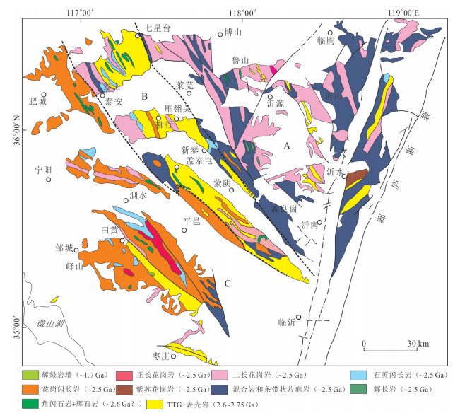
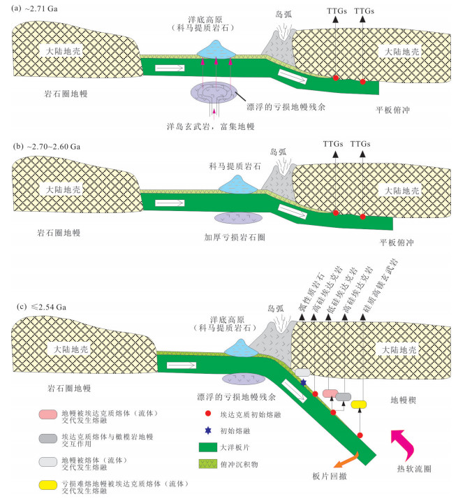
The Luxi district which is located in West Shandong Province is one of the most representative granite-greenstone belts in the Neoarchean of China. Our pioneers have already accumulated rich sources related to tectonic lithostratigraphy, isotopic geochronology, geochemistry, mineralization, and etc. Some geologists also explores progressively the geodynamic features in this era. From the perspective of ocean plate geology, this article examines the previous data of regional geological investigation and research obtained by the predecessors, and shows that the mafic volcanic rocks of the Taishan Complex are composed of two rock associations, komatite-tholeiite and tholeiite-calc alkaline basalt-andesite, respectively. It reflects the evolution process from komatite related to mantle plume in the early stage to calc alkaline basalt-andesite related to arc in the late stage. From island arc type tonalite formed in the early stage of Neoarchean to differentiated trondhjemite formed in the middle stage of Neoarchean, it reflects the characteristics of granite evolution during subduction. The late Neoarchean Siliceous High Mg Basalt is the product of the active continental margin magma arc. The discovery of Ruby in the Taishan Complex further indicates that the setting of its formation is related to the subduction of Neoarchean plates. All these provide geological evidence for the existence of new Archean oceanic plate in Luxi District.
The Luxi district which is located in West Shandong Province is one of the most representative granite-greenstone belts in the Neoarchean of China. Our pioneers have already accumulated rich sources related to tectonic lithostratigraphy, isotopic geochronology, geochemistry, mineralization, and etc. Some geologists also explores progressively the geodynamic features in this era. From the perspective of ocean plate geology, this article examines the previous data of regional geological investigation and research obtained by the predecessors, and shows that the mafic volcanic rocks of the Taishan Complex are composed of two rock associations, komatite-tholeiite and tholeiite-calc alkaline basalt-andesite, respectively. It reflects the evolution process from komatite related to mantle plume in the early stage to calc alkaline basalt-andesite related to arc in the late stage. From island arc type tonalite formed in the early stage of Neoarchean to differentiated trondhjemite formed in the middle stage of Neoarchean, it reflects the characteristics of granite evolution during subduction. The late Neoarchean Siliceous High Mg Basalt is the product of the active continental margin magma arc. The discovery of Ruby in the Taishan Complex further indicates that the setting of its formation is related to the subduction of Neoarchean plates. All these provide geological evidence for the existence of new Archean oceanic plate in Luxi District.


2020, 45(7): 2293-2304.
doi: 10.3799/dqkx.2020.070
Abstract:
The complex geological structure background of engineering geological difference in different zones of Sichuan-Tibet railway corridor is deconstructed,described the core idea and scientific significance of ocean plate geology.It is pointed out that there are seven oceanic subduction (Ophiolitic Melange belt) which accretion complex belts running through the Ya'an-Linzhi section of Sichuan-Tibet railway. With the strong uplift of the Qinghai-Tibet Plateau since Miocene,all of them are transformed into neotectonic active zone,active seismic zone,high geothermal active zone and geological disaster frequent zone. It is the key zone for Sichuan-Tibet railway. It is the key point of understanding that what is different geological background structure-rock combinations,different degrees of metamorphism,ordered or disordered structure of different deformation patterns,and restrict the behaviors of different rocks,soils and special unfavorable geological bodies; It is the key to complete the Sichuan-Tibet railway construction with high quality and high standard.
The complex geological structure background of engineering geological difference in different zones of Sichuan-Tibet railway corridor is deconstructed,described the core idea and scientific significance of ocean plate geology.It is pointed out that there are seven oceanic subduction (Ophiolitic Melange belt) which accretion complex belts running through the Ya'an-Linzhi section of Sichuan-Tibet railway. With the strong uplift of the Qinghai-Tibet Plateau since Miocene,all of them are transformed into neotectonic active zone,active seismic zone,high geothermal active zone and geological disaster frequent zone. It is the key zone for Sichuan-Tibet railway. It is the key point of understanding that what is different geological background structure-rock combinations,different degrees of metamorphism,ordered or disordered structure of different deformation patterns,and restrict the behaviors of different rocks,soils and special unfavorable geological bodies; It is the key to complete the Sichuan-Tibet railway construction with high quality and high standard.


2020, 45(7): 2305-2325.
doi: 10.3799/dqkx.2020.120
Abstract:
The paleo-position of ocean and continent has been changing on the earth since the Proterozoic and the oceanic acreage is always larger than the continent's. A paleo-suture zone represents the remant of a paleo-ocean and is considered as the focus on the research of Ocean Plate Stratigraphy (OPS). The paper is aiming to propose the regulations for the division of tectonic-strata super regions and regions in the orogenic belts,based on OPS in China. The OPS can be subdivided into two types in China,N-MORB-type and SSZ-type,respectively corresponding to the main suture zone and subordinate suture zone. The current position for a main suture zone is roughly considered as the position of a tectonic-strata super region. A main suture zone was formed during the disappearing of a large ocean,marked by N-MORB-type ophiolite. The current position for a subordinate suture zone is roughly corresponding to the position of a tectonic-strata region. A subordinate suture zone was formed during the disappearing of a small ocean,marked by SSZ-type ophiolite and developed along the edge of a block or continent. The geological units in a main suture zone mainly consist of ophiolite,seamount and intra-oceanic arc. The positions for these units could be also generally considered as the positions of tectonic-strata regions. The geological units in a subordinate suture zone mainly consist of back-arc,inter-arc and retro-arc and for-arc basins. The positions for these units are basically considered as the positions of tectonic-strata subregions.
The paleo-position of ocean and continent has been changing on the earth since the Proterozoic and the oceanic acreage is always larger than the continent's. A paleo-suture zone represents the remant of a paleo-ocean and is considered as the focus on the research of Ocean Plate Stratigraphy (OPS). The paper is aiming to propose the regulations for the division of tectonic-strata super regions and regions in the orogenic belts,based on OPS in China. The OPS can be subdivided into two types in China,N-MORB-type and SSZ-type,respectively corresponding to the main suture zone and subordinate suture zone. The current position for a main suture zone is roughly considered as the position of a tectonic-strata super region. A main suture zone was formed during the disappearing of a large ocean,marked by N-MORB-type ophiolite. The current position for a subordinate suture zone is roughly corresponding to the position of a tectonic-strata region. A subordinate suture zone was formed during the disappearing of a small ocean,marked by SSZ-type ophiolite and developed along the edge of a block or continent. The geological units in a main suture zone mainly consist of ophiolite,seamount and intra-oceanic arc. The positions for these units could be also generally considered as the positions of tectonic-strata regions. The geological units in a subordinate suture zone mainly consist of back-arc,inter-arc and retro-arc and for-arc basins. The positions for these units are basically considered as the positions of tectonic-strata subregions.


2020, 45(7): 2326-2344.
doi: 10.3799/dqkx.2020.172
Abstract:
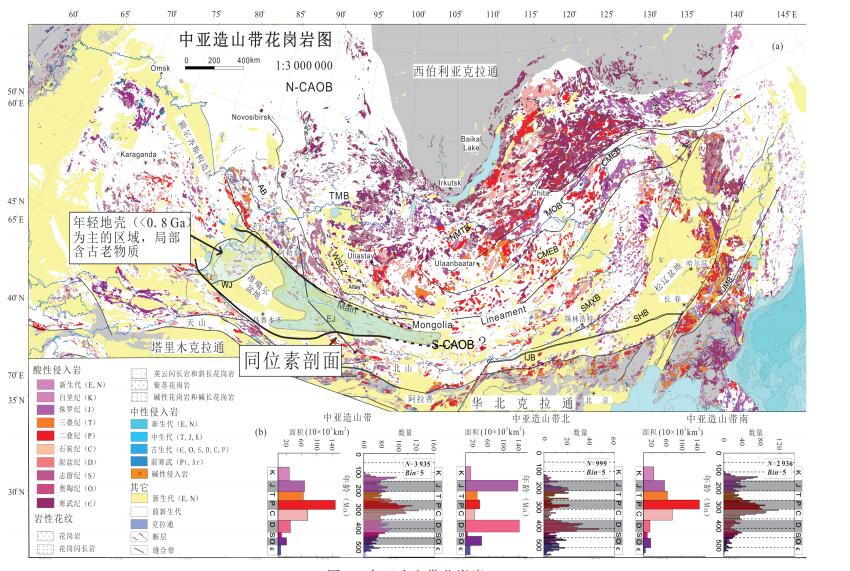
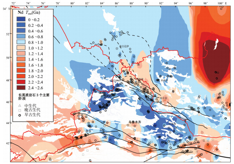
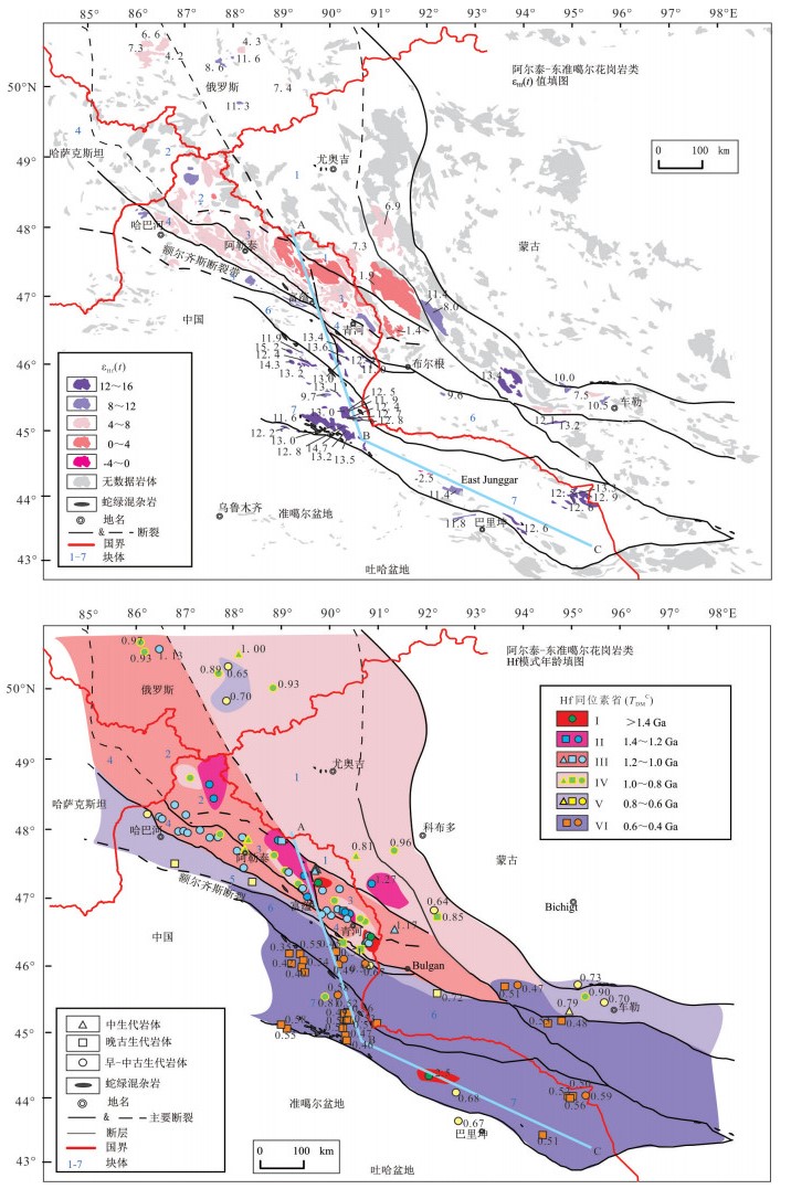
Multiple isotopic mapping of magmatic rocks is a useful tool to unveil the architecture and composition of the deep lithosphere of orogens and to study the crustal growth. As the world's largest and most typical accretionary orogenic belt,the Central Asian Orogenic Belt (CAOB) is an ideal natural laboratory for addressing the scientific issues mentioned above. In this contribution,we synthetically exhibit the recent achievements in isotopic mapping being carried out in northern Xinjiang,SW CAOB,and discuss the relevant issues. Cross-section of Nd-Hf isotopic data across the Altai-Junggar-Tianshan-Beishan orogens preliminarily indicate that some ancient materials are distributed in the central Altai,the Junggar is composed mostly of juvenile components,and the most ancient crustsare found in Eastern Tianshan-Beishan areas. These differences can be attributed to the combination of lateral continental crust growth at the syn-accretionary stage and the vertical growth at late- to post-accretionary stages. The Hf isotopic mapping of felsic rocks in the Western Tianshan and adjacent regions reveals a within-microcontinental heterogeneity in lithospheric architecture,and alternating occurrence in space and time of juvenile and ancient crustal components implies periodic continental growth and reworking. Details of components in the deep lithosphere probed by isotopic mapping,juvenile crustal endmembers particularly,require further studies. We need to explore the results of multi-proxy isotopicsystems and understand the mechanism behind the similarities and differences. Furthermore,deep lithospheric compositions traced by multi-isotopes should be in agreement with geophysical data as well as experimental petrology. Our ultimate goal is to establish a multidisciplinary approach with multi-isotopic mapping as the core,including geophysical detection,deep drilling,and simulation of deep process.
Multiple isotopic mapping of magmatic rocks is a useful tool to unveil the architecture and composition of the deep lithosphere of orogens and to study the crustal growth. As the world's largest and most typical accretionary orogenic belt,the Central Asian Orogenic Belt (CAOB) is an ideal natural laboratory for addressing the scientific issues mentioned above. In this contribution,we synthetically exhibit the recent achievements in isotopic mapping being carried out in northern Xinjiang,SW CAOB,and discuss the relevant issues. Cross-section of Nd-Hf isotopic data across the Altai-Junggar-Tianshan-Beishan orogens preliminarily indicate that some ancient materials are distributed in the central Altai,the Junggar is composed mostly of juvenile components,and the most ancient crustsare found in Eastern Tianshan-Beishan areas. These differences can be attributed to the combination of lateral continental crust growth at the syn-accretionary stage and the vertical growth at late- to post-accretionary stages. The Hf isotopic mapping of felsic rocks in the Western Tianshan and adjacent regions reveals a within-microcontinental heterogeneity in lithospheric architecture,and alternating occurrence in space and time of juvenile and ancient crustal components implies periodic continental growth and reworking. Details of components in the deep lithosphere probed by isotopic mapping,juvenile crustal endmembers particularly,require further studies. We need to explore the results of multi-proxy isotopicsystems and understand the mechanism behind the similarities and differences. Furthermore,deep lithospheric compositions traced by multi-isotopes should be in agreement with geophysical data as well as experimental petrology. Our ultimate goal is to establish a multidisciplinary approach with multi-isotopic mapping as the core,including geophysical detection,deep drilling,and simulation of deep process.


2020, 45(7): 2345-2359.
doi: 10.3799/dqkx.2020.045
Abstract:
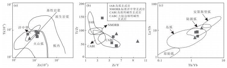
The tectonic nature of Shiquanhe-Yongzhu-Jiali ophiolitic mélange zone andits relationship to the Bangonghu-Nujiang suture zone are key to understanding the Mesozoic tectonic evolution of the Bangonghu-Nujiang Ocean. Geochemistry of basalt and andesitic porphyrite in Longbaesang area are reported in this paper. The results show that the basalt are tholeiitic rocks,and enriched in light rare earth elements and large ion lithophile elements (Rb、Ba、K、Sr、Pb),and depleted Nb,Ta,Ti. All of the geochemistry characteristics of the basalt rocks are the same as typical of island arc tholeiite.The andesitic porphyrite are tholeiitic rocks,which has the trend of evolution to calc alkaline rocks,enriched large ion lithophile elements (Rb、Ba、K、Sr、Pb、U),depleted Nb,Ta,clearly displaying compositional characteristics of island-arc volcanic rocks. Additionally,the compositional characteristics of lower ΣREE (11.8×10⁻⁶-13.8×10⁻⁶)、(La/Yb)N(0.37-0.43) and depleted in light rare earth elements,which are also Similar to normal mid-ocean ridge basalt,Therefore,the andesitic porphyrite may be formed in a immature back-arc basin. Combined with the regional geological data,the tectonic environment of the basalts and andesitic porphyrites both are related to subduction,which respectively,may be formed in the oceanic or the active continental margin of island arc environment and the immature back-arc basin environment,related to the South subduction of Bangonghu-Nujiang ocean crust,which are record the recycling of the Southern subducted Bangonghu-Nujiang oceanic crust during the late Jurassic to the early Cretaceous.
The tectonic nature of Shiquanhe-Yongzhu-Jiali ophiolitic mélange zone andits relationship to the Bangonghu-Nujiang suture zone are key to understanding the Mesozoic tectonic evolution of the Bangonghu-Nujiang Ocean. Geochemistry of basalt and andesitic porphyrite in Longbaesang area are reported in this paper. The results show that the basalt are tholeiitic rocks,and enriched in light rare earth elements and large ion lithophile elements (Rb、Ba、K、Sr、Pb),and depleted Nb,Ta,Ti. All of the geochemistry characteristics of the basalt rocks are the same as typical of island arc tholeiite.The andesitic porphyrite are tholeiitic rocks,which has the trend of evolution to calc alkaline rocks,enriched large ion lithophile elements (Rb、Ba、K、Sr、Pb、U),depleted Nb,Ta,clearly displaying compositional characteristics of island-arc volcanic rocks. Additionally,the compositional characteristics of lower ΣREE (11.8×10⁻⁶-13.8×10⁻⁶)、(La/Yb)N(0.37-0.43) and depleted in light rare earth elements,which are also Similar to normal mid-ocean ridge basalt,Therefore,the andesitic porphyrite may be formed in a immature back-arc basin. Combined with the regional geological data,the tectonic environment of the basalts and andesitic porphyrites both are related to subduction,which respectively,may be formed in the oceanic or the active continental margin of island arc environment and the immature back-arc basin environment,related to the South subduction of Bangonghu-Nujiang ocean crust,which are record the recycling of the Southern subducted Bangonghu-Nujiang oceanic crust during the late Jurassic to the early Cretaceous.


2020, 45(7): 2360-2378.
doi: 10.3799/dqkx.2020.044
Abstract:
The Phanerozoic magmatic activity was strongly in Nenjiang-Heihe area of Heilongjiang Province, a series of large and medium-sized deposits were developed, in order to understand the Paleozoic and Mesozoic ocean-land transition processes and their metallogenic background in the study area, the achievements in magmatic rocks and ore deposits in recent years were systematically summarized, the adakitic rocks, high magnesium rocks and TTG granite, from the interoceanic fore - arc rock assemblage were discussed, in combination with volcanic-sedimentary characteristics, the metallogenic events represented by the ocean-land transition and related deposit types in the study area were discussed. High magnesium rocks of Early Cambrian, Late Cambrian, Middle Ordovician and Early Silurian and adakitic rocks of Early Ordovician, Middle Ordovician and Late Devonian developed in the Paleozoic, in the subduction environment of Nenjiang-Heihe ocean, during the Late Carboniferous-Permian period, it changed to late orogenic-post-orogenic stage, the mineralization was most intensely in Ordovician and was closely related to adakitic rocks and high magnesium rocks from interoceanic fore-arc rock assemblage, the porphyry in the subduction arc-forming stage and the shallow cryogenic hydrothermal metallogenic system appear, and the possible VMS type of deposits, orogenic gold deposits and other ore-prospecting work need to be further strengthened. The Mesozoic development in the study area was related to the southern subduction of the Mongol-Okhorsk oceanic plate in the Middle Triassic, Early Jurassic adakitic rocks and Late Triassic magnesite rocks and Early-middle Jurassic TTG granite, the late Early cretaceous arc volcanic rocks and a series of large and medium-sized gold deposits may be related to the subduction-retreat of the ancient Pacific plate.
The Phanerozoic magmatic activity was strongly in Nenjiang-Heihe area of Heilongjiang Province, a series of large and medium-sized deposits were developed, in order to understand the Paleozoic and Mesozoic ocean-land transition processes and their metallogenic background in the study area, the achievements in magmatic rocks and ore deposits in recent years were systematically summarized, the adakitic rocks, high magnesium rocks and TTG granite, from the interoceanic fore - arc rock assemblage were discussed, in combination with volcanic-sedimentary characteristics, the metallogenic events represented by the ocean-land transition and related deposit types in the study area were discussed. High magnesium rocks of Early Cambrian, Late Cambrian, Middle Ordovician and Early Silurian and adakitic rocks of Early Ordovician, Middle Ordovician and Late Devonian developed in the Paleozoic, in the subduction environment of Nenjiang-Heihe ocean, during the Late Carboniferous-Permian period, it changed to late orogenic-post-orogenic stage, the mineralization was most intensely in Ordovician and was closely related to adakitic rocks and high magnesium rocks from interoceanic fore-arc rock assemblage, the porphyry in the subduction arc-forming stage and the shallow cryogenic hydrothermal metallogenic system appear, and the possible VMS type of deposits, orogenic gold deposits and other ore-prospecting work need to be further strengthened. The Mesozoic development in the study area was related to the southern subduction of the Mongol-Okhorsk oceanic plate in the Middle Triassic, Early Jurassic adakitic rocks and Late Triassic magnesite rocks and Early-middle Jurassic TTG granite, the late Early cretaceous arc volcanic rocks and a series of large and medium-sized gold deposits may be related to the subduction-retreat of the ancient Pacific plate.


2020, 45(7): 2379-2392.
doi: 10.3799/dqkx.2020.100
Abstract:
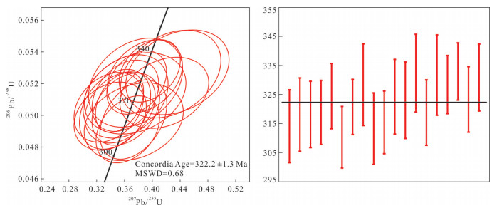
In this study, we carried out zircon LA-ICP-MS U-Pb geochronology, Sr-Nd-Hf isotope geochemistry on the Naolaiketu tonalite to discuss its origin and tectonic setting. The zircon U-Pb age of the rock is 322.2±1.3 Ma, which indicates that the pluton is a product of the Early Carboniferous magmatic event. Geochemically, the tonalite samples are characterized by moderate-high concentrations of SiO2(62.29%-77.17%), low Al2O3 (11.45%-14.11%) and rich in Na2O and poor in K2O, and are enriched in LILE and depleted in HFSE, which show the geochemical characteristics of TTG. The fractionation of LREE and HREE are not obvious, and there arenegative Eu anomaly (δEu=0.64-0.76). The (87Sr/86Sr)i of the rocks are low (0.703 457-0.703 789), εNd(t) are all positive (+8.4 to +9.3).The in-situ zircon Hf isotopic analysis show depleted compositions, and εHf(t) range from +8.1 to +13.3, imply that the magma originated from the subducted oceanic crust. Combined with the analysis of regional geological background, the TTG magma event in Naolaiketu indicates that, the palo-Asian Ocean was not closed in the Carboniferous in the Diyanmiao area of West Ujimqin, and the subduction zone was a thermal structure of warm crust-mantle.
In this study, we carried out zircon LA-ICP-MS U-Pb geochronology, Sr-Nd-Hf isotope geochemistry on the Naolaiketu tonalite to discuss its origin and tectonic setting. The zircon U-Pb age of the rock is 322.2±1.3 Ma, which indicates that the pluton is a product of the Early Carboniferous magmatic event. Geochemically, the tonalite samples are characterized by moderate-high concentrations of SiO2(62.29%-77.17%), low Al2O3 (11.45%-14.11%) and rich in Na2O and poor in K2O, and are enriched in LILE and depleted in HFSE, which show the geochemical characteristics of TTG. The fractionation of LREE and HREE are not obvious, and there arenegative Eu anomaly (δEu=0.64-0.76). The (87Sr/86Sr)i of the rocks are low (0.703 457-0.703 789), εNd(t) are all positive (+8.4 to +9.3).The in-situ zircon Hf isotopic analysis show depleted compositions, and εHf(t) range from +8.1 to +13.3, imply that the magma originated from the subducted oceanic crust. Combined with the analysis of regional geological background, the TTG magma event in Naolaiketu indicates that, the palo-Asian Ocean was not closed in the Carboniferous in the Diyanmiao area of West Ujimqin, and the subduction zone was a thermal structure of warm crust-mantle.


2020, 45(7): 2393-2412.
doi: 10.3799/dqkx.2020.123
Abstract:
Gongpoquan arc extends nearly east-west in Gongpoquan-Shibanjing-Xiaohuangshan area on the north side of Niuquanzi-Xichangjing ophiolite mèlange belt in Beishan orogen. Its material composition, formation age of different rocks and spatial distribution pattern are very important for studying the Early Paleozoic tectonic evolution of Beishan orogen. Based on the study and analysis of data from more than 30 pieces of 1:50 000 regional geological mapping, It's made clear that the Gongpoquan arc is mainly composed of three stages of strong tectono-magmatism, which are gabbro-diorite assemblages and basalts of 510-470 Ma, gneissic tonalites-granodiorite assemblages and a small amount of diorite-quartz diorite assemblages as well as large-scale andesite of 470-430 Ma, syenogranite-monzogranite assemblage of 430-410 Ma.Combined with the regional geological knowledge and the geochemical data of the above rock assemblages, they were formed in three different stages of tectonic evolution:initial subduction, main subduction and post collision periods. The spatial distribution of granite assemblages in the main subduction period has a distribution pattern from south to north. The variations of lithology indicates that the Yueyashan-Xichangjing Ocean has a polarity of northward subduction.
Gongpoquan arc extends nearly east-west in Gongpoquan-Shibanjing-Xiaohuangshan area on the north side of Niuquanzi-Xichangjing ophiolite mèlange belt in Beishan orogen. Its material composition, formation age of different rocks and spatial distribution pattern are very important for studying the Early Paleozoic tectonic evolution of Beishan orogen. Based on the study and analysis of data from more than 30 pieces of 1:50 000 regional geological mapping, It's made clear that the Gongpoquan arc is mainly composed of three stages of strong tectono-magmatism, which are gabbro-diorite assemblages and basalts of 510-470 Ma, gneissic tonalites-granodiorite assemblages and a small amount of diorite-quartz diorite assemblages as well as large-scale andesite of 470-430 Ma, syenogranite-monzogranite assemblage of 430-410 Ma.Combined with the regional geological knowledge and the geochemical data of the above rock assemblages, they were formed in three different stages of tectonic evolution:initial subduction, main subduction and post collision periods. The spatial distribution of granite assemblages in the main subduction period has a distribution pattern from south to north. The variations of lithology indicates that the Yueyashan-Xichangjing Ocean has a polarity of northward subduction.


2020, 45(7): 2413-2425.
doi: 10.3799/dqkx.2020.027
Abstract:
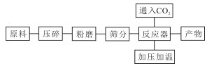
The sharp rise of carbon dioxide concentration has become a very serious problem, so reducing the atmospheric carbon dioxide concentration has become a top priority. Although the potential of marine and geological sequestration is huge, the negative impact of these schemes can not be underestimated. As a new emission reduction scheme, carbon dioxide mineralization can not only fix atmospheric carbon dioxide, generate carbonate products with industrial added value, but also achieve environmental friendliness. Raw materials that can be used for mineralization include natural calcium-rich, magnesium silicate minerals, industrial alkaline waste solids, liquids, magnesium chloride resources in salt lakes, etc. The methods of mineralization are also different. Although the mechanism of how the weathering of silicate rocks can control the long-term climate change has not been determined, there is a consensus that the weathering process has the potential to fix a large amount of CO2. The research on the mineralized CO2 of tailing containing a lot of silicate minerals is a hot spot at present. This paper introduces the research status of mineralized CO2 of tailing and the mineralized potential of several important tailing minerals.
The sharp rise of carbon dioxide concentration has become a very serious problem, so reducing the atmospheric carbon dioxide concentration has become a top priority. Although the potential of marine and geological sequestration is huge, the negative impact of these schemes can not be underestimated. As a new emission reduction scheme, carbon dioxide mineralization can not only fix atmospheric carbon dioxide, generate carbonate products with industrial added value, but also achieve environmental friendliness. Raw materials that can be used for mineralization include natural calcium-rich, magnesium silicate minerals, industrial alkaline waste solids, liquids, magnesium chloride resources in salt lakes, etc. The methods of mineralization are also different. Although the mechanism of how the weathering of silicate rocks can control the long-term climate change has not been determined, there is a consensus that the weathering process has the potential to fix a large amount of CO2. The research on the mineralized CO2 of tailing containing a lot of silicate minerals is a hot spot at present. This paper introduces the research status of mineralized CO2 of tailing and the mineralized potential of several important tailing minerals.


2020, 45(7): 2426-2440.
doi: 10.3799/dqkx.2020.041
Abstract:
A lot of Neoproterozoic magmatic rocks were reported from west to central Yunnan, while these rocks were regarded that they were formed from different tectonic setting. In this paper, we show some granites keeping well granitic texture from Xiangshui granite batholith in Xiangyun county, including different enclaves such as mafic rocks (olivine gabbro) and diorites. In the field, some rocks of granidiorites, quartz diorites, tonalities were formed with the mixed granitic magma around the mafic rocks. Four similar LA-ICP-MS 206Pb/238U weight mean ages of zircons yield 761.9±4.1 Ma, 761.7±4.2 Ma, 761.3±3.7 Ma and 757.5±5.9 Ma. The granites are characterized by high alkaline, moderate Mg# values (38~57, average 50), low TiO2 and P contents, their trace elements show depleted Ta, Nb, Sr, enrichment LREEs and LILEs, depleted HREEs, and have low εNd(t) values of -2.73 to -4.90. All of the geochemical characters suggest that the granitic laves was the results of partial melt of the ancient crust. The olivine gabbro show low K2O content and total oxide rare earth elements (REEs), slightly to no enrichment LREEs and LILEs, and slightly or no depleted Nb-Ta, Zr-Hf values, but of depleted P, and high Mg# values (71-83, average 77), indicating the origin of these mafic rocks from MORB or the margin MORB melt. The diorites and granidiorites exhibit slightly enrichment LREE and LILE compared to HREE, variable Mg# (45-71, average 56), depleted P element, εNd(t) values of -3.83 to -4.42, slightly to no depleted Ta, Nb, Ti, Sr, P elements, these geochemical values are between those rocks of granites and olivine gabbro, which indicate the result of mix magma of MORB-derived melt and partial melt of ancient crust. In the tectonic diagrams, these rocks are plot into the continental arc field related to subduction of oceanic crust down to the Yangtze block, and the mafic magma of MORB were the result of oceanic crust remelting.
A lot of Neoproterozoic magmatic rocks were reported from west to central Yunnan, while these rocks were regarded that they were formed from different tectonic setting. In this paper, we show some granites keeping well granitic texture from Xiangshui granite batholith in Xiangyun county, including different enclaves such as mafic rocks (olivine gabbro) and diorites. In the field, some rocks of granidiorites, quartz diorites, tonalities were formed with the mixed granitic magma around the mafic rocks. Four similar LA-ICP-MS 206Pb/238U weight mean ages of zircons yield 761.9±4.1 Ma, 761.7±4.2 Ma, 761.3±3.7 Ma and 757.5±5.9 Ma. The granites are characterized by high alkaline, moderate Mg# values (38~57, average 50), low TiO2 and P contents, their trace elements show depleted Ta, Nb, Sr, enrichment LREEs and LILEs, depleted HREEs, and have low εNd(t) values of -2.73 to -4.90. All of the geochemical characters suggest that the granitic laves was the results of partial melt of the ancient crust. The olivine gabbro show low K2O content and total oxide rare earth elements (REEs), slightly to no enrichment LREEs and LILEs, and slightly or no depleted Nb-Ta, Zr-Hf values, but of depleted P, and high Mg# values (71-83, average 77), indicating the origin of these mafic rocks from MORB or the margin MORB melt. The diorites and granidiorites exhibit slightly enrichment LREE and LILE compared to HREE, variable Mg# (45-71, average 56), depleted P element, εNd(t) values of -3.83 to -4.42, slightly to no depleted Ta, Nb, Ti, Sr, P elements, these geochemical values are between those rocks of granites and olivine gabbro, which indicate the result of mix magma of MORB-derived melt and partial melt of ancient crust. In the tectonic diagrams, these rocks are plot into the continental arc field related to subduction of oceanic crust down to the Yangtze block, and the mafic magma of MORB were the result of oceanic crust remelting.


2020, 45(7): 2441-2451.
doi: 10.3799/dqkx.2020.068
Abstract:
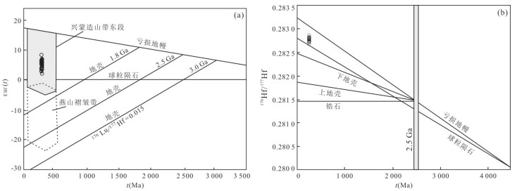
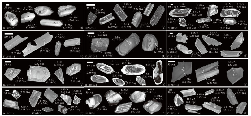
In order to find out whether Mesoproterozoic strata exist in southern Jilin, and to explore the tectonic evolution of this area. U-Pb isotope dating and in situ Lu-Hf isotope test were performed on the detrital zircon samples in this area by LA-MC-ICP-MS. The age of detrital zircon is mainly concentrated in Archean (> 2.5 Ga), εHf(t) values show positive (+1.5 to +7.5 and +1.4 to +4.6), Mesoproterozoic and Paleoproterozoic (1.7~2.3 Ga), and εHf(t) values appear positive and negative (-5.6 to +5.7 and -5.4 to +3.4). It is indicated that the material source are mainly the granites of the Archean and the Late Paleoproterozoic Liaodong-Jinan orogenic belt, and a small amount may be derived from the volcanic rocks and early granites of the orogenic belt. The set of strata may be the Middle Proterozoic caprock deposits after the subduction-collision of the two micro-continental blocks of Longgang and Langlin formed the Jiao-Liao-Ji orogenic/active belt.
In order to find out whether Mesoproterozoic strata exist in southern Jilin, and to explore the tectonic evolution of this area. U-Pb isotope dating and in situ Lu-Hf isotope test were performed on the detrital zircon samples in this area by LA-MC-ICP-MS. The age of detrital zircon is mainly concentrated in Archean (> 2.5 Ga), εHf(t) values show positive (+1.5 to +7.5 and +1.4 to +4.6), Mesoproterozoic and Paleoproterozoic (1.7~2.3 Ga), and εHf(t) values appear positive and negative (-5.6 to +5.7 and -5.4 to +3.4). It is indicated that the material source are mainly the granites of the Archean and the Late Paleoproterozoic Liaodong-Jinan orogenic belt, and a small amount may be derived from the volcanic rocks and early granites of the orogenic belt. The set of strata may be the Middle Proterozoic caprock deposits after the subduction-collision of the two micro-continental blocks of Longgang and Langlin formed the Jiao-Liao-Ji orogenic/active belt.


2020, 45(7): 2452-2468.
doi: 10.3799/dqkx.2020.034
Abstract:
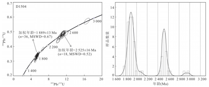
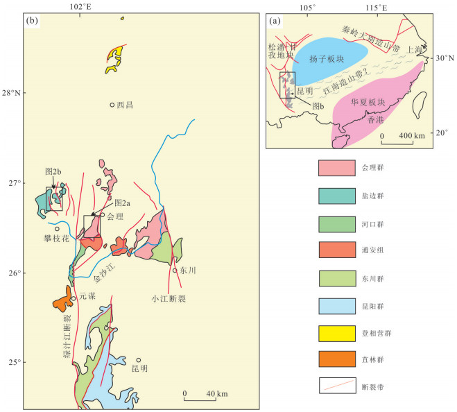
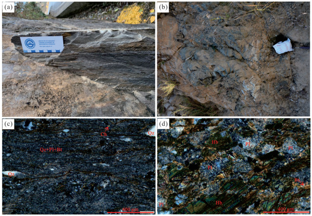
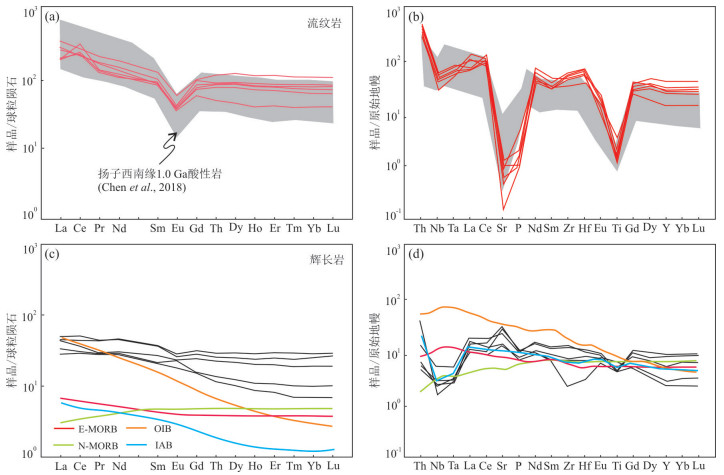
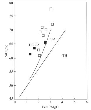
Late Mesoproterozoic to Early Neoproterozoic igneous rocks occur in the southwestern Yangtze block, which had a great bearing on the evolution history of the Yangtze block during the late Mesoproterozoic to early Neoproterozoic. This study reports SHRIMP zircon U-Pb ages and geochemistry data for gabbros that intruded in the Yanbian Group, and that of rhyolites from the upper Tianbaoshan Formation of the Huili Group in the southwestern Yangtze block.The rhyolites were dated at 1 011.9±8.9 Ma and the gabbros were formed at 910.6±4.7 Ma. The rhyolites in the Tianbaoshan Formation were characterized by high SiO2 and K2O contents and high FeOt/MgO ratio. The contents of rare earth elements of rhyolites are high(∑REE=292×10-6-401×10-6), and characterized by LREE-enriched and HREE-depleted patterns[(La/Yb)N=1.77-6.74] with typical depletion of Eu(δEu=0.43-0.56), consistent with the geochemical characteristics of A-type granites. The geochemistry indicates that the rhyolites were derived from the partial melting of previous crust and formed in a continental rift setting. The gabbro shave low rare earth elements(∑REE=54×10-6-98×10-6) and characterized by slightly LREE-enriched and HREE-depleted patterns with unconspicuous Eu anomaly[(La/Yb)N=1.46-4.72, δEu=0.81-1.31] and the trace element patterns with typical depletion of Nb-Ta and Ti but no enrichment of Zr-Hf. The gabbros were derived from the subduction-modified lithospheric mantle wedge and formed in an arc setting. In view of the two episodes of magmatism in the study region, we propose that the tectonic properties changed from a continental rift setting to a compression setting in the southwestern Yangtze Block at 1 000-910 Ma.
Late Mesoproterozoic to Early Neoproterozoic igneous rocks occur in the southwestern Yangtze block, which had a great bearing on the evolution history of the Yangtze block during the late Mesoproterozoic to early Neoproterozoic. This study reports SHRIMP zircon U-Pb ages and geochemistry data for gabbros that intruded in the Yanbian Group, and that of rhyolites from the upper Tianbaoshan Formation of the Huili Group in the southwestern Yangtze block.The rhyolites were dated at 1 011.9±8.9 Ma and the gabbros were formed at 910.6±4.7 Ma. The rhyolites in the Tianbaoshan Formation were characterized by high SiO2 and K2O contents and high FeOt/MgO ratio. The contents of rare earth elements of rhyolites are high(∑REE=292×10-6-401×10-6), and characterized by LREE-enriched and HREE-depleted patterns[(La/Yb)N=1.77-6.74] with typical depletion of Eu(δEu=0.43-0.56), consistent with the geochemical characteristics of A-type granites. The geochemistry indicates that the rhyolites were derived from the partial melting of previous crust and formed in a continental rift setting. The gabbro shave low rare earth elements(∑REE=54×10-6-98×10-6) and characterized by slightly LREE-enriched and HREE-depleted patterns with unconspicuous Eu anomaly[(La/Yb)N=1.46-4.72, δEu=0.81-1.31] and the trace element patterns with typical depletion of Nb-Ta and Ti but no enrichment of Zr-Hf. The gabbros were derived from the subduction-modified lithospheric mantle wedge and formed in an arc setting. In view of the two episodes of magmatism in the study region, we propose that the tectonic properties changed from a continental rift setting to a compression setting in the southwestern Yangtze Block at 1 000-910 Ma.


2020, 45(7): 2469-2484.
doi: 10.3799/dqkx.2020.164
Abstract:
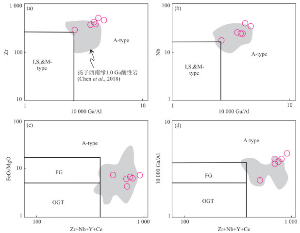
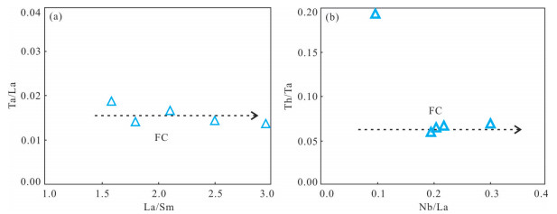
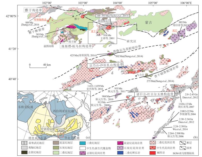
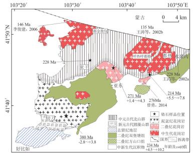
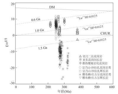
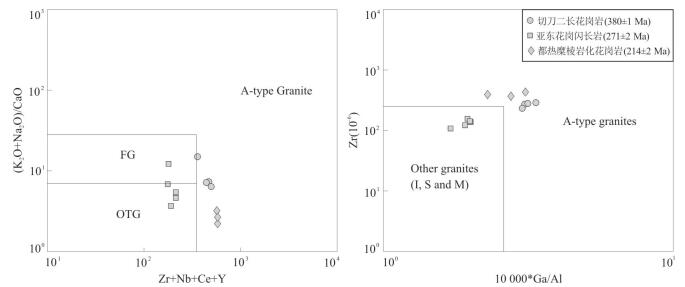
Due to the lack of detailed field geological and high-precision geochronological studies, the basement nature and tectonic attribute of the Yagan area have been poorly understood so far, which prevent the further understanding of the basic architecture and tectonic evolution of the southern Central Asian orogenic belt. Revealing the age and origin of the granitoids is essential for the understanding of the basement characteristics and tectonic architecture. In this paper presents systematic petrology, zircon U-Pb and Hf isotopic studies for the granitoids in the Yagan area.LA-ICP-MS zircon U-Pb isotopic dating results indicate that the biotite-monzonitic granite of Qiedao pluton and granodiorite of Yadong pluton emplaced at 380±1 Ma and 271±2 Ma, respectively. Meanwhile, the zircon U-Pb ages of 228±2 Ma and 214±2 Ma were obtained from the gneissic granite and mylonitic granite (their protoliths are granite rocks) in Paleoproterozic Beishan Group. Mineralogical and geochemical features suggest that the Qiedao and Dure granites are high-K calc-alkaline and metaluminous to slightly peraluminous, belonging to the A-type granites, and the Yadong granodiorites are calc-alkaline I-type granites. The Qiedao biotite-monzonitic granite and Yadong granodiorite have zircon εHf(t) values ranging from -2.8 to +4.3 and the crustal model ages of 1.5 to 1.0 Ga, suggesting that the magma sources were mainly derived from the Meso-proterozoic crustal material.Inherited zircon ages within the gneissic granite are mainly around 0.8-1.0 Ga. These observations, in combination with previous work, indicate that the basement of Yagan area is composed of Meso-Neoproterozoic rocks, and the South Gobi microcontinent might extend into the northern Alxa.
Due to the lack of detailed field geological and high-precision geochronological studies, the basement nature and tectonic attribute of the Yagan area have been poorly understood so far, which prevent the further understanding of the basic architecture and tectonic evolution of the southern Central Asian orogenic belt. Revealing the age and origin of the granitoids is essential for the understanding of the basement characteristics and tectonic architecture. In this paper presents systematic petrology, zircon U-Pb and Hf isotopic studies for the granitoids in the Yagan area.LA-ICP-MS zircon U-Pb isotopic dating results indicate that the biotite-monzonitic granite of Qiedao pluton and granodiorite of Yadong pluton emplaced at 380±1 Ma and 271±2 Ma, respectively. Meanwhile, the zircon U-Pb ages of 228±2 Ma and 214±2 Ma were obtained from the gneissic granite and mylonitic granite (their protoliths are granite rocks) in Paleoproterozic Beishan Group. Mineralogical and geochemical features suggest that the Qiedao and Dure granites are high-K calc-alkaline and metaluminous to slightly peraluminous, belonging to the A-type granites, and the Yadong granodiorites are calc-alkaline I-type granites. The Qiedao biotite-monzonitic granite and Yadong granodiorite have zircon εHf(t) values ranging from -2.8 to +4.3 and the crustal model ages of 1.5 to 1.0 Ga, suggesting that the magma sources were mainly derived from the Meso-proterozoic crustal material.Inherited zircon ages within the gneissic granite are mainly around 0.8-1.0 Ga. These observations, in combination with previous work, indicate that the basement of Yagan area is composed of Meso-Neoproterozoic rocks, and the South Gobi microcontinent might extend into the northern Alxa.


2020, 45(7): 2485-2494.
doi: 10.3799/dqkx.2020.052
Abstract:
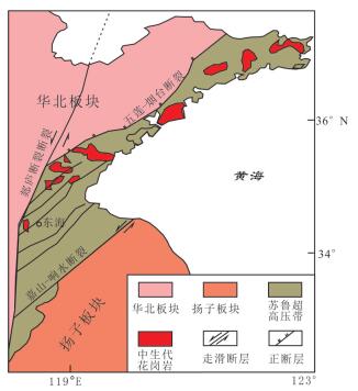
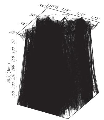
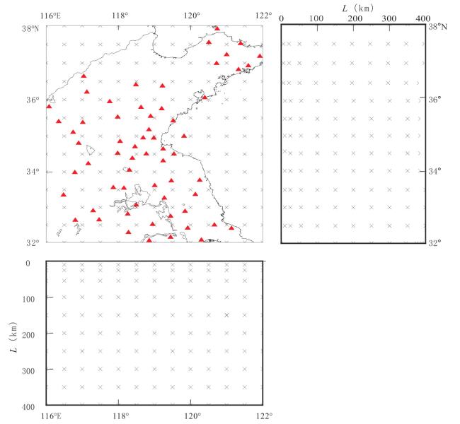
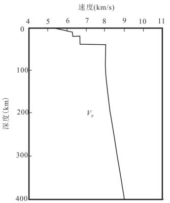
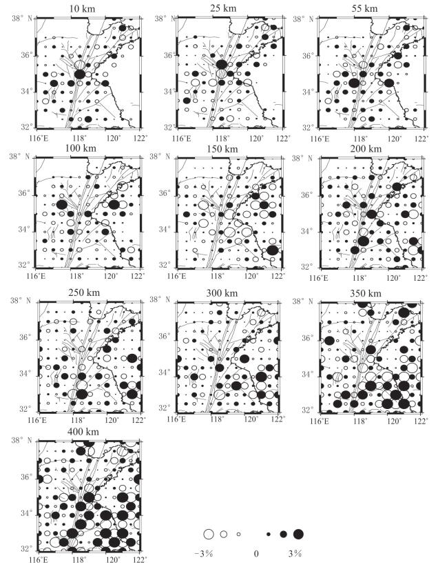
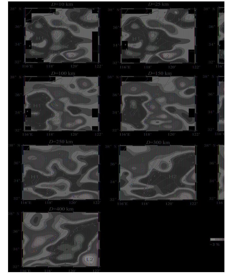
The Sulu Triassic collision zone between the North China block and the Yangtze block contains the largest ultrahigh-pressure (UHP) metamorphic belt in the world. It has become a hot spot in the research of plate convergence, subduction, and collision. We determined a detailed three-dimensional P-wave velocity structure of the crust and upper mantle beneath the Sulu orogenic belt by applying 10 922 arrival times from 1 079 local and regional earthquakes, and 11 931 data from 251 teleseismic events, which were recorded by 64 seismic stations in our study region. Our tomographic imaging shows that prominent low velocity anomalies are imaged beneath Shandong Peninsula and the middle and lower Yangtze River metallogenic belt, which may represent the asthenosphere upwelling.A high velocity anomaly which may represent the subducted Paleo-Tethyan oceanic slab is imaged clearly in the east of Tanlu fault beneath the depth of over 300 km. The crustal and mantle velocity structure of the Sulu orogenic belt formed by the collision of the North China block and the Yangtze block is mainly characterized by high velocity anomalies. The north subduction of the Yangtze block is not obviously, and the North China block is characterized by the southeastward subdction of the high velocity anomalies. The subduction of the north China block can be divided into two subduction styles bounded by 35° N. In the north of the 35°N, the southeastward subduction of North China block is not obvious and is stopped in the west of Tanlu fault. In the south of the 35° N, North China block southeastward subducted under the Sulu orogenic belt.
The Sulu Triassic collision zone between the North China block and the Yangtze block contains the largest ultrahigh-pressure (UHP) metamorphic belt in the world. It has become a hot spot in the research of plate convergence, subduction, and collision. We determined a detailed three-dimensional P-wave velocity structure of the crust and upper mantle beneath the Sulu orogenic belt by applying 10 922 arrival times from 1 079 local and regional earthquakes, and 11 931 data from 251 teleseismic events, which were recorded by 64 seismic stations in our study region. Our tomographic imaging shows that prominent low velocity anomalies are imaged beneath Shandong Peninsula and the middle and lower Yangtze River metallogenic belt, which may represent the asthenosphere upwelling.A high velocity anomaly which may represent the subducted Paleo-Tethyan oceanic slab is imaged clearly in the east of Tanlu fault beneath the depth of over 300 km. The crustal and mantle velocity structure of the Sulu orogenic belt formed by the collision of the North China block and the Yangtze block is mainly characterized by high velocity anomalies. The north subduction of the Yangtze block is not obviously, and the North China block is characterized by the southeastward subdction of the high velocity anomalies. The subduction of the north China block can be divided into two subduction styles bounded by 35° N. In the north of the 35°N, the southeastward subduction of North China block is not obvious and is stopped in the west of Tanlu fault. In the south of the 35° N, North China block southeastward subducted under the Sulu orogenic belt.


2020, 45(7): 2495-2507.
doi: 10.3799/dqkx.2020.031
Abstract:
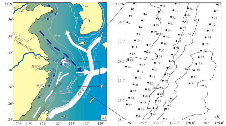
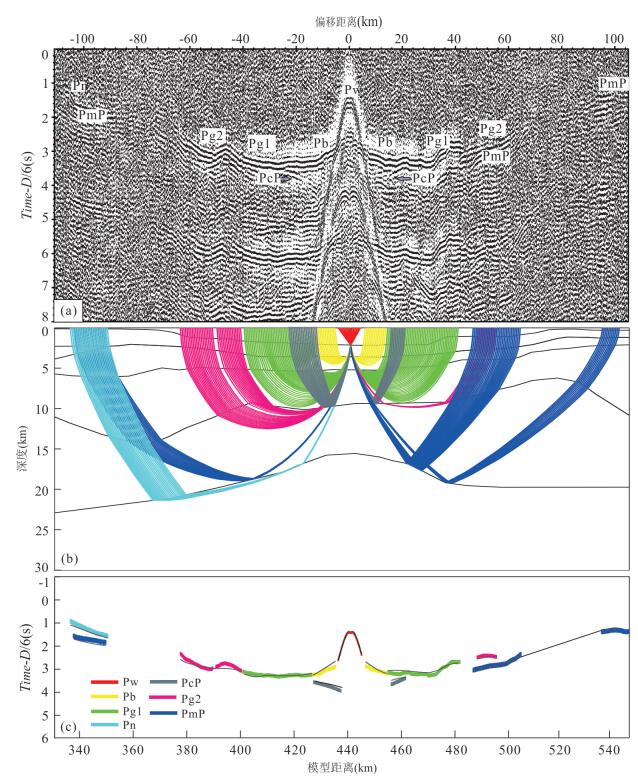
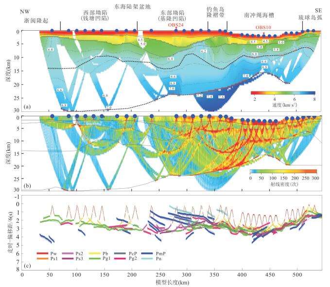
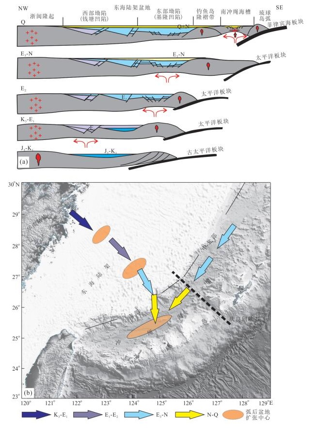
To study the deep crust structure in the back-arc area, we present an active source wide-angle reflection/refraction profile in the back-arc area of Ryukyu Island in the East China Sea in 2015, which passed through the East China Sea shelf basin, the Diaoyu island uplift belt, the southern Okinawa Trough and the Ryukyu Island arc. The 2D velocity structure model obtained by forward modeling and travel tomographic shows that the depth of Moho rises significantly from more than 30 km in the East China Sea shelf to about 16 km in the axis of the Okinawa Trough, and the crustal thickness decreases significantly. A series of discontinuous high-velocity zones with velocity 6.8-7.3 km/s were identified in the lower crust of the back-arc region, which is a remarkable manifestation of mantle upwelling. From the perspective of deep crustal structure, the model clearly shows the tectonic migration from west to east in the back-arc area of the Western Pacific since Cenozoic and confirms that the as thenosphere upwelling in the deep part of the Western Pacific oceanic-continental transition zone transits continuously to the ocean during the back-arc spreading process, forming the tectonic migration from west to east, and driving the episodic extension of the lithosphere. We believe that the Cenozoic tectonic migration to the ocean is a series of back-arc deep-shallow geodynamic effects caused by the retreat of the Pacific subduction zone.
To study the deep crust structure in the back-arc area, we present an active source wide-angle reflection/refraction profile in the back-arc area of Ryukyu Island in the East China Sea in 2015, which passed through the East China Sea shelf basin, the Diaoyu island uplift belt, the southern Okinawa Trough and the Ryukyu Island arc. The 2D velocity structure model obtained by forward modeling and travel tomographic shows that the depth of Moho rises significantly from more than 30 km in the East China Sea shelf to about 16 km in the axis of the Okinawa Trough, and the crustal thickness decreases significantly. A series of discontinuous high-velocity zones with velocity 6.8-7.3 km/s were identified in the lower crust of the back-arc region, which is a remarkable manifestation of mantle upwelling. From the perspective of deep crustal structure, the model clearly shows the tectonic migration from west to east in the back-arc area of the Western Pacific since Cenozoic and confirms that the as thenosphere upwelling in the deep part of the Western Pacific oceanic-continental transition zone transits continuously to the ocean during the back-arc spreading process, forming the tectonic migration from west to east, and driving the episodic extension of the lithosphere. We believe that the Cenozoic tectonic migration to the ocean is a series of back-arc deep-shallow geodynamic effects caused by the retreat of the Pacific subduction zone.


2020, 45(7): 2508-2523.
doi: 10.3799/dqkx.2020.035
Abstract:
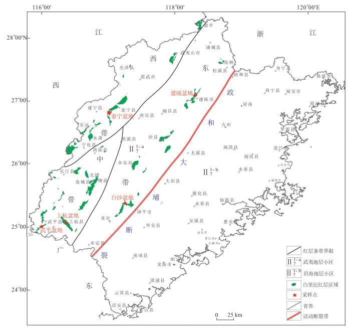
In order to research the age and tectonic setting of the Cretaceous red beds in Fujian Province, typical red bed basins were selected on the west of the Zhenghe-Dapu fault, LA-ICP-MS zircon isotopic dating and rock geochemical analysis were performed on volcanic rocks in different basins. The results of zircon U-Pb isotopic dating show that the Shaxian Formation has a longer duration, which is 127-87 Ma, and its overall age should be roughly in early Late Cretaceous, and the lower part will enter the late Early Cretaceous. The age of the Chong'an Formation is 100.0±1.2 Ma, which is early Late Cretaceous. The results of petrochemical chemistry indicate that the volcanic rocks in the Cretaceous red beds are crust-originated and are a set of calcareous series rhyolites, which is in the extensional environment and formed by regional fault depression of tectonic activity.
In order to research the age and tectonic setting of the Cretaceous red beds in Fujian Province, typical red bed basins were selected on the west of the Zhenghe-Dapu fault, LA-ICP-MS zircon isotopic dating and rock geochemical analysis were performed on volcanic rocks in different basins. The results of zircon U-Pb isotopic dating show that the Shaxian Formation has a longer duration, which is 127-87 Ma, and its overall age should be roughly in early Late Cretaceous, and the lower part will enter the late Early Cretaceous. The age of the Chong'an Formation is 100.0±1.2 Ma, which is early Late Cretaceous. The results of petrochemical chemistry indicate that the volcanic rocks in the Cretaceous red beds are crust-originated and are a set of calcareous series rhyolites, which is in the extensional environment and formed by regional fault depression of tectonic activity.


2020, 45(7): 2524-2537.
doi: 10.3799/dqkx.2020.050
Abstract:
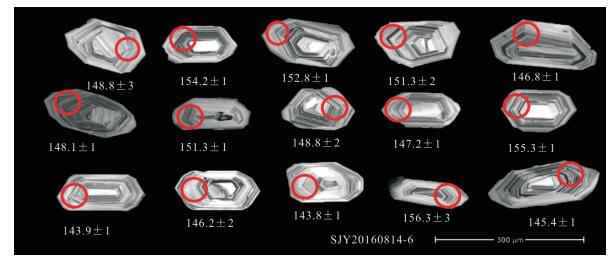
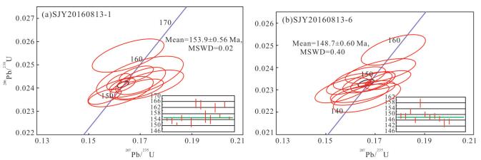
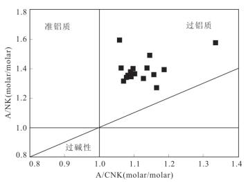
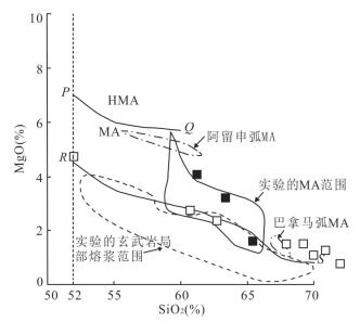
The Mesozoic intrusive rocks are widely developed in Heihuashan area in the north of Heihe City, Heilongjiang Province, but the formation age, rock assemble age and genesis of the intrusive rocks are still unclear. In this paper, the intrusive rocks in Heihuashan area have been studied in the field, petrography, petrology, geochronology and petrochemistry, in order to discuss the formation age, petrogenesis and geotectonic background of these rocks, For two monzonitic granites, the weighted average ages of zircon U-Pb dating by LA-ICP-MS are 148.7±0.6 Ma and 153.50±0.56 Ma respectively, indicating that they were formed in the Late Jurassic. The intrusive rock assemblage of tonalite(T1), trondhjemite(T2), and granite(G) etc indicates a rock assembleage of T1T2G in arc environment. The above granitoids are rich in silicon, alkali, high potassium, peraluminium (A/CNK is greater than 1), and low in Fe2O3T. The rocks belong to high potassium calcium alkali series in the SiO2-K2O diagram, low Fe- calcium alkali (LF-CA) series in SiO2-MgO diagram and calcium alkali or alkali calcium in SiO2-(Na2O+K2O-CaO)diagram. The distribution pattern of rare earth element is right-leaning, with LREE relatively enriched and HREE depleted, giving (La/Yb)n=13.78-29.85 and no negative Eu anomaly or weak positive Eu anomaly or weak negative Eu anomaly.The granitoids are characterized by high Sr and low Y, with Sr/Y ratio ranging from 29.53 to 103.80, which are characteristic of "C-type" adakites. The above rock assemblages and their characteristics all indicate the properties of arc igneous rocks. Combined with the tectonic environment, it is believed that the Late Jurassic granitoids in this area were formed in the southwardly subduction environment of the Mongolia-Okhotsk Ocean.The magma maybe derived from the partial melting of the thickening lower crust of Xing'an Arc.
The Mesozoic intrusive rocks are widely developed in Heihuashan area in the north of Heihe City, Heilongjiang Province, but the formation age, rock assemble age and genesis of the intrusive rocks are still unclear. In this paper, the intrusive rocks in Heihuashan area have been studied in the field, petrography, petrology, geochronology and petrochemistry, in order to discuss the formation age, petrogenesis and geotectonic background of these rocks, For two monzonitic granites, the weighted average ages of zircon U-Pb dating by LA-ICP-MS are 148.7±0.6 Ma and 153.50±0.56 Ma respectively, indicating that they were formed in the Late Jurassic. The intrusive rock assemblage of tonalite(T1), trondhjemite(T2), and granite(G) etc indicates a rock assembleage of T1T2G in arc environment. The above granitoids are rich in silicon, alkali, high potassium, peraluminium (A/CNK is greater than 1), and low in Fe2O3T. The rocks belong to high potassium calcium alkali series in the SiO2-K2O diagram, low Fe- calcium alkali (LF-CA) series in SiO2-MgO diagram and calcium alkali or alkali calcium in SiO2-(Na2O+K2O-CaO)diagram. The distribution pattern of rare earth element is right-leaning, with LREE relatively enriched and HREE depleted, giving (La/Yb)n=13.78-29.85 and no negative Eu anomaly or weak positive Eu anomaly or weak negative Eu anomaly.The granitoids are characterized by high Sr and low Y, with Sr/Y ratio ranging from 29.53 to 103.80, which are characteristic of "C-type" adakites. The above rock assemblages and their characteristics all indicate the properties of arc igneous rocks. Combined with the tectonic environment, it is believed that the Late Jurassic granitoids in this area were formed in the southwardly subduction environment of the Mongolia-Okhotsk Ocean.The magma maybe derived from the partial melting of the thickening lower crust of Xing'an Arc.


2020, 45(7): 2538-2554.
doi: 10.3799/dqkx.2020.057
Abstract:
Mesozoic igneous rocks are widely developed in Heihe area, but the age of formation, igneous rock assemblages at different stages, petrogenesis, and the geotectonic background of the formation are still controversial. This article conducts detailed field, petrology, geochemistry, and chronology studies on intrusive rocks around the Woniu Lake in Heihe area to reveal the age and genesis of the rocks. LA-ICP-MS zircon dating of diorite and monzogranite shows that they formed at 175.53±0.53 Ma and 177.25±0.45 Ma.Igneous rocks in this area during this period were mainly intrusive rocks and some dike rocks, intrusive rocks are mainly granite, granodiorite, and a small amount of monzonite, dike rocks are mainly granitic dikes and dioritic dikes.Plutonic facies rocks were T1T2G1G2 rock assemblage contained some Tonalite(T1)-Trondhjemite(T2) rocks and more Granodiorite(G1)-Granite(G2) rocks.The rock assemblage were mainly subalkaline series on SiO2-(Na2O+K2O) diagram and on SiO2-K2O diagram were mainly high-potassium calcium-alkali series, were calcium alkali or alkali calcium series on SiO2-(Na2O+K2O-CaO)diagram.They were metaluminums-peraluminous series rocks. Most of the rocks in SiO2-MgO diagram were similar to magnesium andesite(MA) series.Trace elements spider diagrams were generally enriched in LILE, such as Rb, K, Pb, depleted in Nb, Ta, La, Ce, Ti. The REE patterns were right-inclined, LREE were steeper and HREE were gentler. The rock assemblages and their characteristics all indicated the characteristics of island arc magmatic rocks. Based on the discrimination of the tectonic environment, it is considered that the rock assemblages were formed in the environment related to ocean subduction. Magma may have formed in the local melting of the subducting basaltic crust reacted with the overlying mantle wedge and the local melting of the crust under the Xing'an arc.It is considered to be related to the evolution of the northern Mongolia-Okhotsk Ocean.
Mesozoic igneous rocks are widely developed in Heihe area, but the age of formation, igneous rock assemblages at different stages, petrogenesis, and the geotectonic background of the formation are still controversial. This article conducts detailed field, petrology, geochemistry, and chronology studies on intrusive rocks around the Woniu Lake in Heihe area to reveal the age and genesis of the rocks. LA-ICP-MS zircon dating of diorite and monzogranite shows that they formed at 175.53±0.53 Ma and 177.25±0.45 Ma.Igneous rocks in this area during this period were mainly intrusive rocks and some dike rocks, intrusive rocks are mainly granite, granodiorite, and a small amount of monzonite, dike rocks are mainly granitic dikes and dioritic dikes.Plutonic facies rocks were T1T2G1G2 rock assemblage contained some Tonalite(T1)-Trondhjemite(T2) rocks and more Granodiorite(G1)-Granite(G2) rocks.The rock assemblage were mainly subalkaline series on SiO2-(Na2O+K2O) diagram and on SiO2-K2O diagram were mainly high-potassium calcium-alkali series, were calcium alkali or alkali calcium series on SiO2-(Na2O+K2O-CaO)diagram.They were metaluminums-peraluminous series rocks. Most of the rocks in SiO2-MgO diagram were similar to magnesium andesite(MA) series.Trace elements spider diagrams were generally enriched in LILE, such as Rb, K, Pb, depleted in Nb, Ta, La, Ce, Ti. The REE patterns were right-inclined, LREE were steeper and HREE were gentler. The rock assemblages and their characteristics all indicated the characteristics of island arc magmatic rocks. Based on the discrimination of the tectonic environment, it is considered that the rock assemblages were formed in the environment related to ocean subduction. Magma may have formed in the local melting of the subducting basaltic crust reacted with the overlying mantle wedge and the local melting of the crust under the Xing'an arc.It is considered to be related to the evolution of the northern Mongolia-Okhotsk Ocean.


2020, 45(7): 2555-2570.
doi: 10.3799/dqkx.2020.043
Abstract:
In this paper, we carry out research on intermediate-acid intrusive rocks in Shujiadian area in aspect of zircon LA-MC-ICP-MS Lu-Hf isotopes combining previous geochemical data. The characteristics of major and trace elements show that the rocks belong to metaluminous series with attributes of island arc magmatic rocks, and may have experienced assimilation-fractional crystallization (AFC) process. We considered that the Early Cretaceous magmatic activity might relate to the oblique subduction of the Pacific plate in the beginning of the Cretaceous, and the evolution of the intrusive rocks in the area were subject to the regional tectonic stress field. The Hf isotope analysis shows that except two inherited zircon cores, the εHf(t) values are negative, with shoshonite series being -8.6 to -4.1 and High-K calc-alkaline series -13.4 to -4.7. Comparing to the high-K calc-alkaline series rocks, the εHf(t) values of the shoshonite series are closer to chondrite evolution line. Considering from the variance of εHf(t) values for the two series, though they both originated from enriched mantle and were contaminated with crustal material during magmatic evolution, the high-K series was contaminated more during this process.
In this paper, we carry out research on intermediate-acid intrusive rocks in Shujiadian area in aspect of zircon LA-MC-ICP-MS Lu-Hf isotopes combining previous geochemical data. The characteristics of major and trace elements show that the rocks belong to metaluminous series with attributes of island arc magmatic rocks, and may have experienced assimilation-fractional crystallization (AFC) process. We considered that the Early Cretaceous magmatic activity might relate to the oblique subduction of the Pacific plate in the beginning of the Cretaceous, and the evolution of the intrusive rocks in the area were subject to the regional tectonic stress field. The Hf isotope analysis shows that except two inherited zircon cores, the εHf(t) values are negative, with shoshonite series being -8.6 to -4.1 and High-K calc-alkaline series -13.4 to -4.7. Comparing to the high-K calc-alkaline series rocks, the εHf(t) values of the shoshonite series are closer to chondrite evolution line. Considering from the variance of εHf(t) values for the two series, though they both originated from enriched mantle and were contaminated with crustal material during magmatic evolution, the high-K series was contaminated more during this process.


2020, 45(7): 2571-2584.
doi: 10.3799/dqkx.2020.040
Abstract:
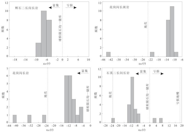
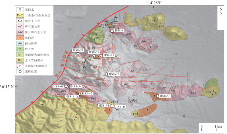
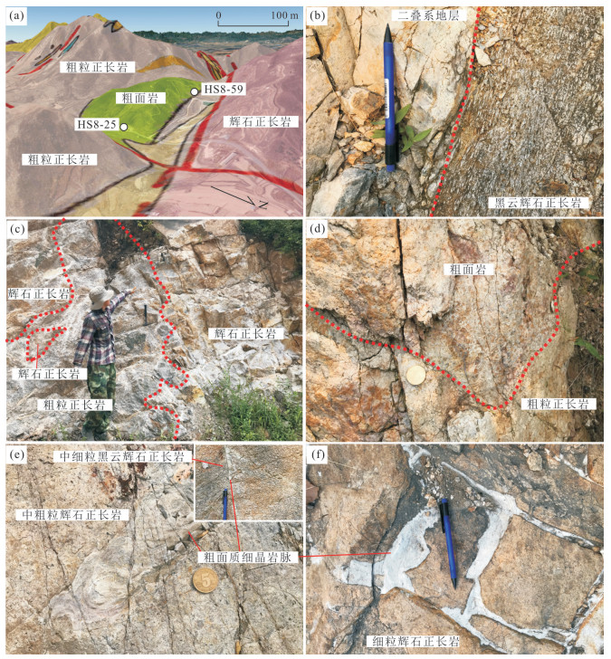
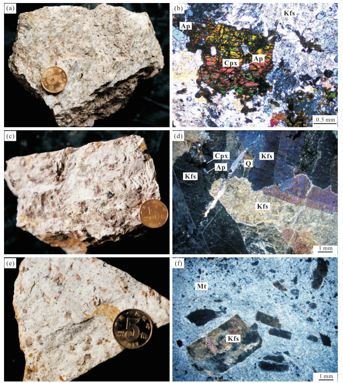
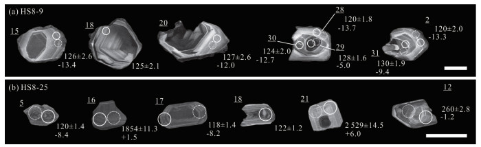
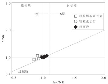
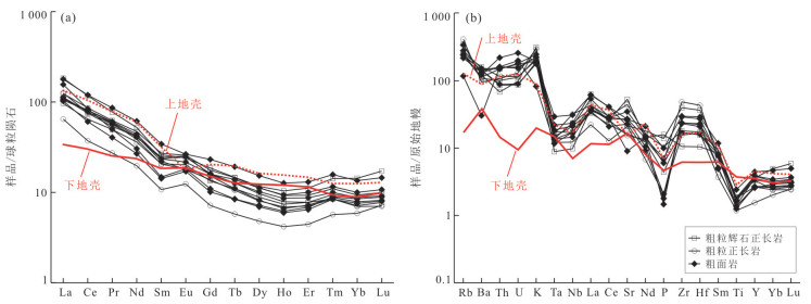
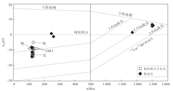
In order to understand the source and genesis of the Hongshan syenite complex, and the rapid surface uplift-erosion phenomenon accompanying its formation, on the basis of detailed field geological surveys, petrology and geochemistry, U-Pb chronology and zircon Lu-Hf isotope studies were used. The result show that:the U-Pb dating of coarse pyroxene syenite and trachyte zircon in the Hongshan syenite complex yields age of 125.6±1.2 Ma and 121.9±2.3 Ma, respectively. Coarse syenite's age is between 125.6±1.2 Ma and 121.9±2.3 Ma, The rock belongs to high-silicon, alkali-rich, aluminum-rich, magnesium-depleted, and low-Mg# metaluminous-peraluminous alkaline rocks, that have undergone a lot of crustal fluid transformation; coarse pyroxene syenite. Coarse-grained pyroxene syenite zircon has a similar core-edge structure of common developmental age. The core εHf (t) is -5.0 to -8.4, which has a high U, Th, and Pb content. The edges are consistent with the zircon characteristics of the trachyte at the same period, εHf (t)=-11.3 to -14.4, and low content of U, Th, and Pb, which indicates that the magma in the early stage of crystallization of zircon has the characteristics of crustal origin. the coarse-faced rocks of the ejected facies are directly covered on the coarse-grained ortho rocks of the central facies. This phenomenon indicates that the formation process of Hongshan syenite complex was accompanied by rapid uplift and erosion of the surface. The formation process of the Hongshan syenite complex is closely related to demolition, which is the response of the North China Craton thinning in the shallow surface.
In order to understand the source and genesis of the Hongshan syenite complex, and the rapid surface uplift-erosion phenomenon accompanying its formation, on the basis of detailed field geological surveys, petrology and geochemistry, U-Pb chronology and zircon Lu-Hf isotope studies were used. The result show that:the U-Pb dating of coarse pyroxene syenite and trachyte zircon in the Hongshan syenite complex yields age of 125.6±1.2 Ma and 121.9±2.3 Ma, respectively. Coarse syenite's age is between 125.6±1.2 Ma and 121.9±2.3 Ma, The rock belongs to high-silicon, alkali-rich, aluminum-rich, magnesium-depleted, and low-Mg# metaluminous-peraluminous alkaline rocks, that have undergone a lot of crustal fluid transformation; coarse pyroxene syenite. Coarse-grained pyroxene syenite zircon has a similar core-edge structure of common developmental age. The core εHf (t) is -5.0 to -8.4, which has a high U, Th, and Pb content. The edges are consistent with the zircon characteristics of the trachyte at the same period, εHf (t)=-11.3 to -14.4, and low content of U, Th, and Pb, which indicates that the magma in the early stage of crystallization of zircon has the characteristics of crustal origin. the coarse-faced rocks of the ejected facies are directly covered on the coarse-grained ortho rocks of the central facies. This phenomenon indicates that the formation process of Hongshan syenite complex was accompanied by rapid uplift and erosion of the surface. The formation process of the Hongshan syenite complex is closely related to demolition, which is the response of the North China Craton thinning in the shallow surface.


2020, 45(7): 2585-2597.
doi: 10.3799/dqkx.2020.099
Abstract:
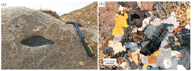
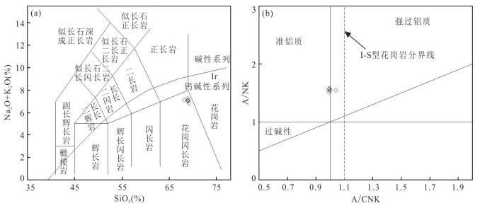
Daolundaba Cu polymetallic deposit islocated in southern segment of Great Hinggan Ling metallogenic belt. In this study, we carried out chronological studies of LA-ICP-MS zircon U-Pb ages, zircon trace element and Lu-Hf isotope for the biotite granites in Daolundaba deposit. LA-ICP-MS zircon U-Pb dating results suggested that the formation age of the biotite granites range from 282.2±4.5-287.0±3.7 Ma.Lu-Hf isotope analysis of the biotite granite showed that the biotite granites had high isotopic compositions of 176Hf/177Hf (mean values of 0.282 770 and 0.282 769) and low isotopic compositions of 176Lu/177Hf (mean values of 0.002 224 and 0.001 984), εHf(t) values range from 3.05-8.58 and 2.31-7.36, with older two-stage ages (730.22-1 083.46 Ma and 812.42-1 134.56 Ma). Zircon trace element results suggest eda S-type granites characteristic with al ow Nb(< 2×10⁻⁶)values and large negative Euanomalies. The forming mean temperatures of the biotite granite calculated by zircon Tithermometer are 770℃ and 785℃, indicated that its magmas is like lytorelate to a subducted environment, and the source region probably experienced partial melting with water nearly saturation. The Daolundaba copper polymetallic deposit was formed in the Late Permian subduction environment.
Daolundaba Cu polymetallic deposit islocated in southern segment of Great Hinggan Ling metallogenic belt. In this study, we carried out chronological studies of LA-ICP-MS zircon U-Pb ages, zircon trace element and Lu-Hf isotope for the biotite granites in Daolundaba deposit. LA-ICP-MS zircon U-Pb dating results suggested that the formation age of the biotite granites range from 282.2±4.5-287.0±3.7 Ma.Lu-Hf isotope analysis of the biotite granite showed that the biotite granites had high isotopic compositions of 176Hf/177Hf (mean values of 0.282 770 and 0.282 769) and low isotopic compositions of 176Lu/177Hf (mean values of 0.002 224 and 0.001 984), εHf(t) values range from 3.05-8.58 and 2.31-7.36, with older two-stage ages (730.22-1 083.46 Ma and 812.42-1 134.56 Ma). Zircon trace element results suggest eda S-type granites characteristic with al ow Nb(< 2×10⁻⁶)values and large negative Euanomalies. The forming mean temperatures of the biotite granite calculated by zircon Tithermometer are 770℃ and 785℃, indicated that its magmas is like lytorelate to a subducted environment, and the source region probably experienced partial melting with water nearly saturation. The Daolundaba copper polymetallic deposit was formed in the Late Permian subduction environment.


2020, 45(7): 2598-2609.
doi: 10.3799/dqkx.2020.162
Abstract:
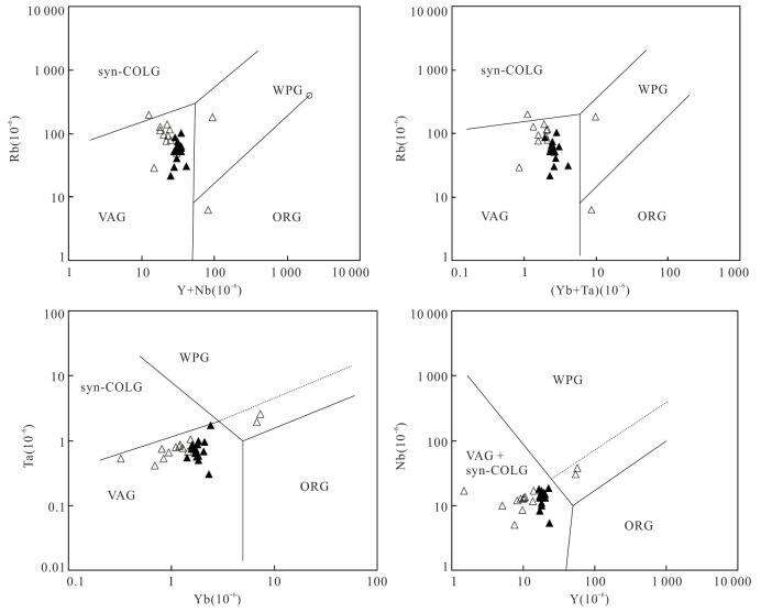
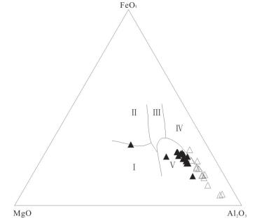
The Late Paleozoic granitic rocks, which is batholith-like, in Aquedun, the west of East Kunlun mountains are mainly distributed in the area of Baozigou. The geochemical characteristics showed that it has calc-alkaline and weak peraluminous (A/CNK=0.99-1.04).The standardized distribution of chondrites of rare earth elements is steep on the left and slow on the right with negative Eu anomaly(δEu=0.73-0.97). Trace elements show losses of high-field strength elements such as Nb, Ta and Ti, which are believed to be formed in the continental margin arc environment and belong to the I-type granite. By the technique of LA-ICP-MS, zircon U-Pb dating of the granitic rock shows that the age of the monzonitic granite is 281.5±4.0 Ma. It is believed that the granite formed in the late of Early Permian. Combined with the regional tectonic evolution, it shows that the Paleotethys ocean began to subducting to the Tarim plate in the late of Early Permian, which may represent the earliest time of subduction, and the Paleotethys ocean was at the end of extension and the beginning of subduction transition.
The Late Paleozoic granitic rocks, which is batholith-like, in Aquedun, the west of East Kunlun mountains are mainly distributed in the area of Baozigou. The geochemical characteristics showed that it has calc-alkaline and weak peraluminous (A/CNK=0.99-1.04).The standardized distribution of chondrites of rare earth elements is steep on the left and slow on the right with negative Eu anomaly(δEu=0.73-0.97). Trace elements show losses of high-field strength elements such as Nb, Ta and Ti, which are believed to be formed in the continental margin arc environment and belong to the I-type granite. By the technique of LA-ICP-MS, zircon U-Pb dating of the granitic rock shows that the age of the monzonitic granite is 281.5±4.0 Ma. It is believed that the granite formed in the late of Early Permian. Combined with the regional tectonic evolution, it shows that the Paleotethys ocean began to subducting to the Tarim plate in the late of Early Permian, which may represent the earliest time of subduction, and the Paleotethys ocean was at the end of extension and the beginning of subduction transition.


2020, 45(7): 2610-2628.
doi: 10.3799/dqkx.2020.190
Abstract:
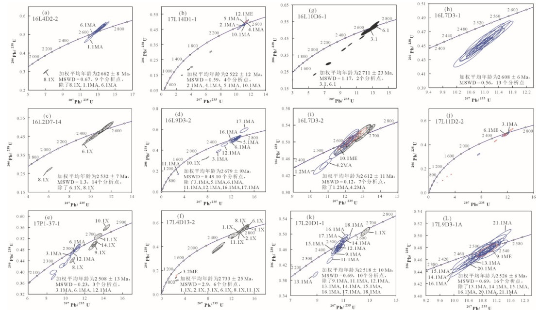
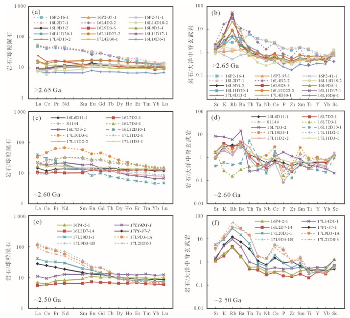
This study reports SHRIMP U-Pb zircon ages and element compositions of meta-gabbros and related rocks from the Qixingtai area, western Shandong. They intrude the Neoarchean supracrustal and TTG rocks. The formation ages can be divided into three groups based on SHRIMP U-Pb dating on 12 samples:2 662- > 2 711 Ma, 2 608-2 618 Ma and 2 508-2 526 Ma. The formation ages of other rock samples for element analyses are determined in terms of their spatial distribution, field features and the relationships with the samples dated. > 2.65 Ga gabbros are derived from enriched and depleted mantles, respectively.~2.6 Ga gabbro has no enrichment of the LREE relative to the HREE, but shows LILE enrichment and weakly negative Nb, Ta and P anomalies. It is considered that the gabbro is derived from depleted mantle source, probably with continental contamination.~2.6 Ga meta-pyroxenite shows enrichment of middle REE, as a result of crystallization and accumulation of clinopyroxene.~2.5 Ga meta-gabbros are variations in REE composition from slight deplation of LREE to HREE, and flat REE pattern to enrichment of of LREE to HREE.~2.5 Ga meta-gabbroic diorite has higher REE contents and is more strongly enriched in LREE and LILE and depleted in Nb and Ta compared with~2.5 Ga meta-gabbro. Combined with early study, the conclusions can be drawn as follows:(1) In the Qixingtai area, meta-gabbros and related rocks of three periods have been identified, with the~2.6 Ga rocks being the largest in distribution scale; (2) the rocks of different ages are different in geochemical composition, showing complexities of source regions and formation processes; (3) In western Shandong, continuous mafic magmatism occurred in early Neoarchean from > 2.7 Ga to 2.6 Ga, being probably related to mantle underplating; (4)~2.5 Ga mafic meta-gabbro-diorite rocks are discovered for the first time in the Qixintai area, providing a direct evidence that the heat source is from mantle for the widespread anatexis of~2.5 Ga in Belt A.
This study reports SHRIMP U-Pb zircon ages and element compositions of meta-gabbros and related rocks from the Qixingtai area, western Shandong. They intrude the Neoarchean supracrustal and TTG rocks. The formation ages can be divided into three groups based on SHRIMP U-Pb dating on 12 samples:2 662- > 2 711 Ma, 2 608-2 618 Ma and 2 508-2 526 Ma. The formation ages of other rock samples for element analyses are determined in terms of their spatial distribution, field features and the relationships with the samples dated. > 2.65 Ga gabbros are derived from enriched and depleted mantles, respectively.~2.6 Ga gabbro has no enrichment of the LREE relative to the HREE, but shows LILE enrichment and weakly negative Nb, Ta and P anomalies. It is considered that the gabbro is derived from depleted mantle source, probably with continental contamination.~2.6 Ga meta-pyroxenite shows enrichment of middle REE, as a result of crystallization and accumulation of clinopyroxene.~2.5 Ga meta-gabbros are variations in REE composition from slight deplation of LREE to HREE, and flat REE pattern to enrichment of of LREE to HREE.~2.5 Ga meta-gabbroic diorite has higher REE contents and is more strongly enriched in LREE and LILE and depleted in Nb and Ta compared with~2.5 Ga meta-gabbro. Combined with early study, the conclusions can be drawn as follows:(1) In the Qixingtai area, meta-gabbros and related rocks of three periods have been identified, with the~2.6 Ga rocks being the largest in distribution scale; (2) the rocks of different ages are different in geochemical composition, showing complexities of source regions and formation processes; (3) In western Shandong, continuous mafic magmatism occurred in early Neoarchean from > 2.7 Ga to 2.6 Ga, being probably related to mantle underplating; (4)~2.5 Ga mafic meta-gabbro-diorite rocks are discovered for the first time in the Qixintai area, providing a direct evidence that the heat source is from mantle for the widespread anatexis of~2.5 Ga in Belt A.


2020, 45(7): 2629-2649.
doi: 10.3799/dqkx.2020.018
Abstract:
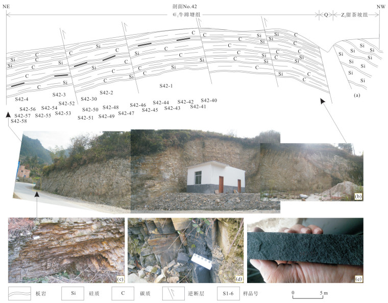
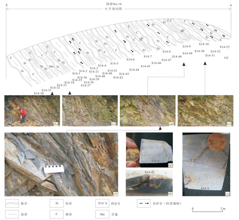
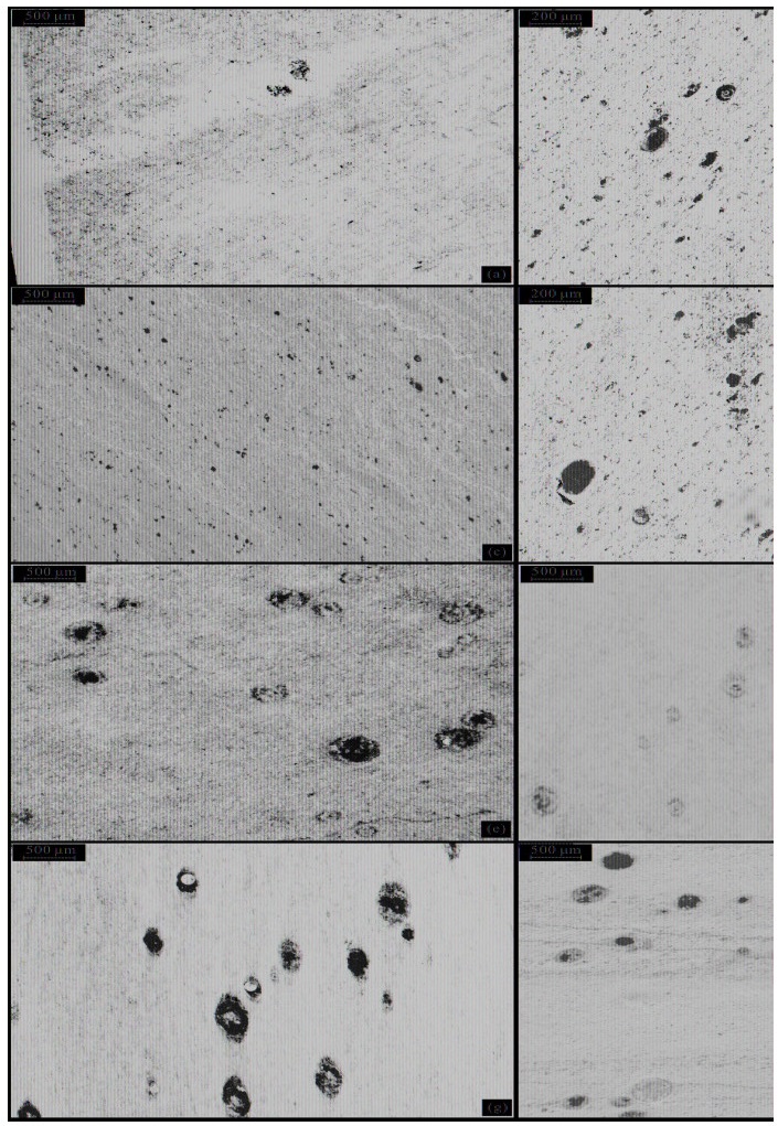
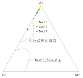
In order to solve the dispute-"deep sea" or "shallow sea" about the Cambrian Terreneuvian-Series 2 sedimentary environment of central-southern area of Hunan and Jiangxi, this paper further analyzed sedimentary environment such as paleo-water depth by investigating the petrological characteristics, radiolarian distribution and lithofacies of eight sections for these strata. According to the investigation, suspected radiolarians found in Loudi, Shaoyang, Hengyang and Pingxiang areas were deposited in the basin center and the source of Si in these strata are biogenic. Horizontal beddings representing weak hydrodynamic force are developed in central and southern parts of Hunan and Jiangxi; the average value of Td of the greywacke is 5.94; the average value of δ30Si is 0.1‰; five types of lithofacies and three types of lithofacies associations (middle fan subfacies of submarine fan, outer fan subfacies of submarine fan, and continental rise subfacies). Taking major element, trace element and REE contents into consideration, we think that the sea water of the central-southern area of Hunan and Jiangxi was stagnant; the study area was a continental slope-rise with a bathyal environment in the Cambrian Terreneuvian-Series 2, relatively shallow in the southeast.
In order to solve the dispute-"deep sea" or "shallow sea" about the Cambrian Terreneuvian-Series 2 sedimentary environment of central-southern area of Hunan and Jiangxi, this paper further analyzed sedimentary environment such as paleo-water depth by investigating the petrological characteristics, radiolarian distribution and lithofacies of eight sections for these strata. According to the investigation, suspected radiolarians found in Loudi, Shaoyang, Hengyang and Pingxiang areas were deposited in the basin center and the source of Si in these strata are biogenic. Horizontal beddings representing weak hydrodynamic force are developed in central and southern parts of Hunan and Jiangxi; the average value of Td of the greywacke is 5.94; the average value of δ30Si is 0.1‰; five types of lithofacies and three types of lithofacies associations (middle fan subfacies of submarine fan, outer fan subfacies of submarine fan, and continental rise subfacies). Taking major element, trace element and REE contents into consideration, we think that the sea water of the central-southern area of Hunan and Jiangxi was stagnant; the study area was a continental slope-rise with a bathyal environment in the Cambrian Terreneuvian-Series 2, relatively shallow in the southeast.


2020, 45(7): 2650-2661.
doi: 10.3799/dqkx.2020.065
Abstract:
In the process of compiling 1:2.5 million lunar digital geological maps, lack of uniform and standard geological map symbols、drawing template, and there are difficulties in extracting information between different lunar maps. To solve the problem, through the ArcGIS platform, combined with other vector-based graphics software, based on Chang'e's data from the Chinese lunar prospector mission, combined with the symbols of the first lunar geological map of China, 1:2.5 million lunar geological Map of the Sinus Iridium quadrangle(LQ-4).We have designed and compiled a new symbol library for the lunar geological map, the library contains a variety of geological information, lunar craters and crater materials, basin formation, structures, and rock types. We set up a category-stored and portable symbol library, and a unified, standard drawing template. This set of standardized symbol library is conducive to the cooperation of scientific research institutions to complete the 1:2.5 million digital moon mapping project, it improves the efficiency of drawing, at the same time, it also laid a foundation for the geological mapping of terrestrial planet in China and abroad.
In the process of compiling 1:2.5 million lunar digital geological maps, lack of uniform and standard geological map symbols、drawing template, and there are difficulties in extracting information between different lunar maps. To solve the problem, through the ArcGIS platform, combined with other vector-based graphics software, based on Chang'e's data from the Chinese lunar prospector mission, combined with the symbols of the first lunar geological map of China, 1:2.5 million lunar geological Map of the Sinus Iridium quadrangle(LQ-4).We have designed and compiled a new symbol library for the lunar geological map, the library contains a variety of geological information, lunar craters and crater materials, basin formation, structures, and rock types. We set up a category-stored and portable symbol library, and a unified, standard drawing template. This set of standardized symbol library is conducive to the cooperation of scientific research institutions to complete the 1:2.5 million digital moon mapping project, it improves the efficiency of drawing, at the same time, it also laid a foundation for the geological mapping of terrestrial planet in China and abroad.

2020, 45(7): 2662-2672.
doi: 10.3799/dqkx.2020.171
Abstract:
The Huangshan section in Harbin is considered as a standard Quaternary sedimentary sequence for terrestrial strata in Northeast China. Due to the lack of absolute age data, there are different results about its stratigraphic division and the chronostratigraphy. In this paper, a detailed magnetostratigraphic investigation, coupled with AMS14C, OSL and other chronological data was carried out on the Huangshan section. The chronological framework of Quaternary strata of the Huangshan section is redefined. The results show that the magnetic polarity stratigraphy includes late Matuyama negative polarity chron to Brunhes positive polarity chron in the Huangshan section. The B/M boundary is at 46.7 m in lower part of the section, and the initial deposition age of the section is earlier than 0.90 Ma. The Holocene and Upper Pleistocene lower boundaries are determined according to AMS14C and OSL ages. The sequence of Huangshan section comprises in chronological order the Xiahuangshan, Shanghuangshan, Harbin, Guxiangtun and Tantu Formations. The age of each lithostratigraphic unit in the Quaternary is determined as follows:the Xiahuangshan Formation is deposited earlier than 900 ka BP; the age of the Shanghuangshan Formation is 138-580 ka BP, that of the Harbin Formation is 79-138 ka BP, that of the Guxiangtun Formation is 12-79 ka BP, and the age of the Tantu Formation is~12 ka BP. The results provide new data for the Quaternary stratigraphic system of Huangshan section, and the division and correlation of Quaternary strata in Northeast China.
The Huangshan section in Harbin is considered as a standard Quaternary sedimentary sequence for terrestrial strata in Northeast China. Due to the lack of absolute age data, there are different results about its stratigraphic division and the chronostratigraphy. In this paper, a detailed magnetostratigraphic investigation, coupled with AMS14C, OSL and other chronological data was carried out on the Huangshan section. The chronological framework of Quaternary strata of the Huangshan section is redefined. The results show that the magnetic polarity stratigraphy includes late Matuyama negative polarity chron to Brunhes positive polarity chron in the Huangshan section. The B/M boundary is at 46.7 m in lower part of the section, and the initial deposition age of the section is earlier than 0.90 Ma. The Holocene and Upper Pleistocene lower boundaries are determined according to AMS14C and OSL ages. The sequence of Huangshan section comprises in chronological order the Xiahuangshan, Shanghuangshan, Harbin, Guxiangtun and Tantu Formations. The age of each lithostratigraphic unit in the Quaternary is determined as follows:the Xiahuangshan Formation is deposited earlier than 900 ka BP; the age of the Shanghuangshan Formation is 138-580 ka BP, that of the Harbin Formation is 79-138 ka BP, that of the Guxiangtun Formation is 12-79 ka BP, and the age of the Tantu Formation is~12 ka BP. The results provide new data for the Quaternary stratigraphic system of Huangshan section, and the division and correlation of Quaternary strata in Northeast China.


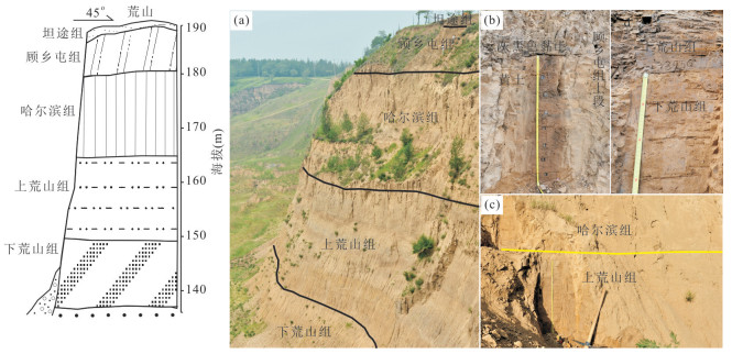

2020, 45(7): 2673-2683.
doi: 10.3799/dqkx.2020.112
Abstract:
Sanmen Formation, deposited in Weihe basin and Sanmenxia basin, recorded the regional sedimentary history from Pliocene to Pleistocene. This formation is of great significance to understand regional paleoenvironment and basin evolution. The sedimentary facies analysis and source reconstruction of Sanmen Formation indicated a great environment changes in 2.8-2.6 Ma, Weihe basin changed from deep lake to shallow lake deposition in 2.8-2.6 Ma, with the water level decreasing, while Sanmenxia basin changed from fluvial facies to shore-shallow lake, with the water level rising. Combined with the results of paleogeomorphic reconstruction and regional stress inversion, Weihe basin and Sanmenxia basin were properbably independent with each other in Pliocene. In the Early Pleistocene, these two basins were connected. The water in Weihe basin flow into Sanmenxia basin, forming the Paleo-Sanmen Lake. By comparing the results of regional tectonic events and provenance analysis, it is concluded that the rapid uplift of Tibet Plateau may be the trigger force of the basin and regional drainage evolution.
Sanmen Formation, deposited in Weihe basin and Sanmenxia basin, recorded the regional sedimentary history from Pliocene to Pleistocene. This formation is of great significance to understand regional paleoenvironment and basin evolution. The sedimentary facies analysis and source reconstruction of Sanmen Formation indicated a great environment changes in 2.8-2.6 Ma, Weihe basin changed from deep lake to shallow lake deposition in 2.8-2.6 Ma, with the water level decreasing, while Sanmenxia basin changed from fluvial facies to shore-shallow lake, with the water level rising. Combined with the results of paleogeomorphic reconstruction and regional stress inversion, Weihe basin and Sanmenxia basin were properbably independent with each other in Pliocene. In the Early Pleistocene, these two basins were connected. The water in Weihe basin flow into Sanmenxia basin, forming the Paleo-Sanmen Lake. By comparing the results of regional tectonic events and provenance analysis, it is concluded that the rapid uplift of Tibet Plateau may be the trigger force of the basin and regional drainage evolution.

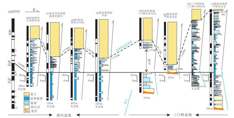


2020, 45(7): 2684-2696.
doi: 10.3799/dqkx.2020.014
Abstract:
The Bohai Sea (BS) is a semi-enclosed sea connected to the North Yellow Sea only via the Bohai Strait. Its stratigraphic evolution during the Late Quaternary has been complex and unresolved. Moreover, the timing of Late Quaternary transgression has been a matter of controversy. In order to study the stratigraphic sequence in the western BS during the Late Quaternary, high-resolution seismic reflection data in conjunction with depositional stratigraphy of typical cores were analyzed. The results indicate that high-resolution seismic profiles from the study area were subdivided into seven seismic units (U5, U4-2, U4-1, U3, U2, U1-2, U1-1 in ascending order), which were clearly correLated with the depositional units of core TJC-1.These units constitute three distinctive sequences (SQ3, SQ2, SQ1 from bottom to up) bounded by two sequence boundaries (R5, R3) with obvious depositional hiatus, correLated with sea-level lowstands of MIS4 and MIS2, respectively. SQ3 consists of the lower transgressive systems tract (TST) and highstand systems tract (HST) (U5, interactive deposits of littoral and neritic facies in MIS5), and the upper regressive systems tract (RST) (U4-2, littoral facies in early MIS4). SQ2 is composed of lowstand systems tract (LST) (U4-1, fluvial and lacustrine facies in middle-Late MIS4 correlating with the Huanghe River and Luanhe River) and TST (U3, littoral facies during the early-middle MIS3) from the bottom up. SQ1 comprises LST (U2, fluvial and lacustrine during Last Glacial Maximum correlating with Luanhe River), TST (U1-2, littoral facies during the early-middle Holocene) and HST (U1-1, neritic facies since the sea-level highstand of Holocene). Stratigraphy development in the study area during the Late Quaternary was governed mainly by sea-level changes, provenance, the Bohai Strait topography and the active faults.
The Bohai Sea (BS) is a semi-enclosed sea connected to the North Yellow Sea only via the Bohai Strait. Its stratigraphic evolution during the Late Quaternary has been complex and unresolved. Moreover, the timing of Late Quaternary transgression has been a matter of controversy. In order to study the stratigraphic sequence in the western BS during the Late Quaternary, high-resolution seismic reflection data in conjunction with depositional stratigraphy of typical cores were analyzed. The results indicate that high-resolution seismic profiles from the study area were subdivided into seven seismic units (U5, U4-2, U4-1, U3, U2, U1-2, U1-1 in ascending order), which were clearly correLated with the depositional units of core TJC-1.These units constitute three distinctive sequences (SQ3, SQ2, SQ1 from bottom to up) bounded by two sequence boundaries (R5, R3) with obvious depositional hiatus, correLated with sea-level lowstands of MIS4 and MIS2, respectively. SQ3 consists of the lower transgressive systems tract (TST) and highstand systems tract (HST) (U5, interactive deposits of littoral and neritic facies in MIS5), and the upper regressive systems tract (RST) (U4-2, littoral facies in early MIS4). SQ2 is composed of lowstand systems tract (LST) (U4-1, fluvial and lacustrine facies in middle-Late MIS4 correlating with the Huanghe River and Luanhe River) and TST (U3, littoral facies during the early-middle MIS3) from the bottom up. SQ1 comprises LST (U2, fluvial and lacustrine during Last Glacial Maximum correlating with Luanhe River), TST (U1-2, littoral facies during the early-middle Holocene) and HST (U1-1, neritic facies since the sea-level highstand of Holocene). Stratigraphy development in the study area during the Late Quaternary was governed mainly by sea-level changes, provenance, the Bohai Strait topography and the active faults.


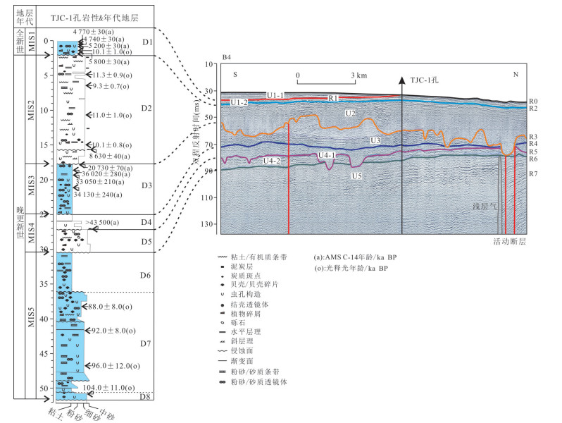

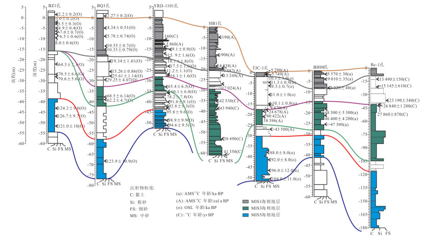

2020, 45(7): 2697-2708.
doi: 10.3799/dqkx.2020.073
Abstract:
The study of coastal currents variations in the Yangtze River mouth has significance for the understanding of riverine sediment 'source to sink' processes in this region. The post-glacial core sediments from the northern Yangtze River mouth, along with sedimentary structures and distributions of grain size and benthic foraminifera, show an estuarine depositional system characterized by tidal sand ridge in Early Holocene and a deltaic system consists of prodelta, delta front slope and delta front. Based on changes in the dominant microfauna species, two main current patterns prevailed in this region during most of the Holocene:one is the Yellow Sea coastal current (YSCC) and the other is the Yangtze dilute water (YDW). in Early Holocene, the YSCC dominated this area and the effect of YDW gradually strengthened. The YDW clearly weakened due to the sea level rise in early Middle Holocene. Then the East China Sea water mass (ESWM) penetrated the area dominated by mixed water mass consists of YDW, YSCC, Zhe-Min coastal current (ZMCC) and Yellow Sea cold water (YSCW), yet the Yangtze plume prevailed due to the rapid seaward migration of the Yangtze mouth.The YDW dominated this area again in Late Holocene.
The study of coastal currents variations in the Yangtze River mouth has significance for the understanding of riverine sediment 'source to sink' processes in this region. The post-glacial core sediments from the northern Yangtze River mouth, along with sedimentary structures and distributions of grain size and benthic foraminifera, show an estuarine depositional system characterized by tidal sand ridge in Early Holocene and a deltaic system consists of prodelta, delta front slope and delta front. Based on changes in the dominant microfauna species, two main current patterns prevailed in this region during most of the Holocene:one is the Yellow Sea coastal current (YSCC) and the other is the Yangtze dilute water (YDW). in Early Holocene, the YSCC dominated this area and the effect of YDW gradually strengthened. The YDW clearly weakened due to the sea level rise in early Middle Holocene. Then the East China Sea water mass (ESWM) penetrated the area dominated by mixed water mass consists of YDW, YSCC, Zhe-Min coastal current (ZMCC) and Yellow Sea cold water (YSCW), yet the Yangtze plume prevailed due to the rapid seaward migration of the Yangtze mouth.The YDW dominated this area again in Late Holocene.


Grain Size Compositions and Their Influencing Factors of the Surface Sediments in Eastern China Seas
2020, 45(7): 2709-2721.
doi: 10.3799/dqkx.2020.028
Abstract:
Based on 1 438 grain size data obtained by marine regional geologic survey, surface sediments of the eastern China Seas are divided into seven types including sandy silt, silty sand, silt, sand, sandy mud, muddy sand and mud by Folk nomenclature.Meanwhile, the grain size features and their parameters are well described.Among them, sandy silt, silty sand, and silty sand are the three main sediment types, accounting for 34.70%, 24.20% and 15.51% respectively.The distribution of silty sand is strip-shaped in the south area.Silty sand is mainly distributed in Zhejiang and Fujian coastal zones, the western Bohai Sea, the central and northern areas of the southern Yellow Sea.Sand is mainly distributed on the East China Sea shelf, Yangtze Shoal, Subei Shoal and western Korea Bay.The influence factors of the sediments distribution include provenance, hydrodynamic environment, water depth, topography and geomorphology, etc. The sea level changes and ocean circulations during the Late Quaternary control the sediment flux into the seas and the sedimentary system on the shelves.Based on the dynamic properties of Folk classification and the type distributions, four kind of sedimentary areas are mainly identified in the eastern China Seas, such as estuarine deposition areas, shelf muddy deposition areas, tidal deposition areas and residual deposition areas.The formation mechanism and influence factors of different sedimentary areas are significantly different, which reflects the process of clastic sediment migration with the sea level changes affected by the special topography of the eastern China Seas.
Based on 1 438 grain size data obtained by marine regional geologic survey, surface sediments of the eastern China Seas are divided into seven types including sandy silt, silty sand, silt, sand, sandy mud, muddy sand and mud by Folk nomenclature.Meanwhile, the grain size features and their parameters are well described.Among them, sandy silt, silty sand, and silty sand are the three main sediment types, accounting for 34.70%, 24.20% and 15.51% respectively.The distribution of silty sand is strip-shaped in the south area.Silty sand is mainly distributed in Zhejiang and Fujian coastal zones, the western Bohai Sea, the central and northern areas of the southern Yellow Sea.Sand is mainly distributed on the East China Sea shelf, Yangtze Shoal, Subei Shoal and western Korea Bay.The influence factors of the sediments distribution include provenance, hydrodynamic environment, water depth, topography and geomorphology, etc. The sea level changes and ocean circulations during the Late Quaternary control the sediment flux into the seas and the sedimentary system on the shelves.Based on the dynamic properties of Folk classification and the type distributions, four kind of sedimentary areas are mainly identified in the eastern China Seas, such as estuarine deposition areas, shelf muddy deposition areas, tidal deposition areas and residual deposition areas.The formation mechanism and influence factors of different sedimentary areas are significantly different, which reflects the process of clastic sediment migration with the sea level changes affected by the special topography of the eastern China Seas.
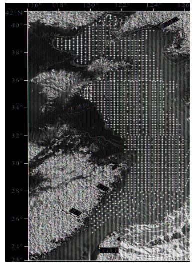


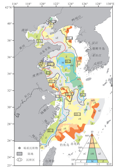
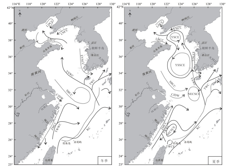

2020, 45(7): 2722-2734.
doi: 10.3799/dqkx.2020.046
Abstract:
The relative contents of clay minerals in 80 surface sediment samples were analyzed by X-ray diffraction. The results showed that the content of illite (65.1%) was the highest in the surface sediment clay minerals in the northeastern part of the east China sea, followed by chlorite (26.6%), kaolinite (8.9%) and smectite (4.3%). In mineral assemblages, illite-chlorite-kaolinite-smectite type is dominant, while illite-chlorite-kaolinite type is less. From the outer shelf to Okinawa Trough, the distribution of illite content was low-high-low-high. Chlorite distribution was low-high-low. The distribution trend of kaolinite is obviously different from that of illite and chlorite. The smectite was absent in some areas and the high value area was patchy in the outer shelf with water depth less than 100 meters. Fast clustering analysis shows that clay minerals can be divided into three types:Yangtze River-like, Yellow River-like and Taiwan-like, which covered in four regions. The "Yellow River-like" clay minerals are mainly transported from the Yellow River and the abandoned Yellow River by the coastal current of the Yellow Sea. They are distributed in the outer shelf area north of 29.5°N and west of 127°E, and don't cross the East China Sea shelf into the Okinawa Trough. The "Yangtze-like" clay minerals covered in the outer continental shelf were mainly paleo-Yangtze materials in the low sea level period, mixed with a small amount of suspended materials from the modern Yangtze River. The "Yangtze-like" clay minerals covered in the Okinawa Trough were mainly derived from the paleo-Yangtze materials in the low sea level period. The "Taiwan-like" clay minerals are mainly controlled by the Kuroshio, which are transported from Taiwan through the southern Okinawa Trough and deposited along the continental slope.
The relative contents of clay minerals in 80 surface sediment samples were analyzed by X-ray diffraction. The results showed that the content of illite (65.1%) was the highest in the surface sediment clay minerals in the northeastern part of the east China sea, followed by chlorite (26.6%), kaolinite (8.9%) and smectite (4.3%). In mineral assemblages, illite-chlorite-kaolinite-smectite type is dominant, while illite-chlorite-kaolinite type is less. From the outer shelf to Okinawa Trough, the distribution of illite content was low-high-low-high. Chlorite distribution was low-high-low. The distribution trend of kaolinite is obviously different from that of illite and chlorite. The smectite was absent in some areas and the high value area was patchy in the outer shelf with water depth less than 100 meters. Fast clustering analysis shows that clay minerals can be divided into three types:Yangtze River-like, Yellow River-like and Taiwan-like, which covered in four regions. The "Yellow River-like" clay minerals are mainly transported from the Yellow River and the abandoned Yellow River by the coastal current of the Yellow Sea. They are distributed in the outer shelf area north of 29.5°N and west of 127°E, and don't cross the East China Sea shelf into the Okinawa Trough. The "Yangtze-like" clay minerals covered in the outer continental shelf were mainly paleo-Yangtze materials in the low sea level period, mixed with a small amount of suspended materials from the modern Yangtze River. The "Yangtze-like" clay minerals covered in the Okinawa Trough were mainly derived from the paleo-Yangtze materials in the low sea level period. The "Taiwan-like" clay minerals are mainly controlled by the Kuroshio, which are transported from Taiwan through the southern Okinawa Trough and deposited along the continental slope.