2021 Vol. 46, No. 1
Display Method:
 PDF 477KB
2021, 46(1): 1-12.
doi: 10.3799/dqkx.2020.019
Abstract:
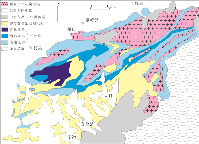
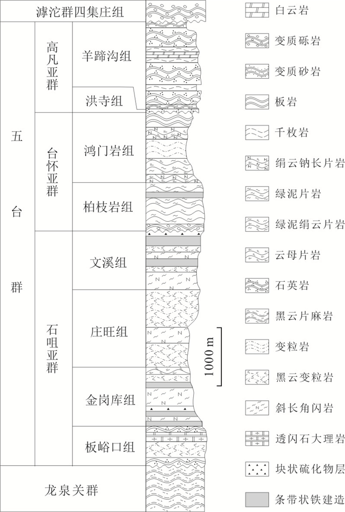
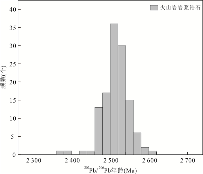
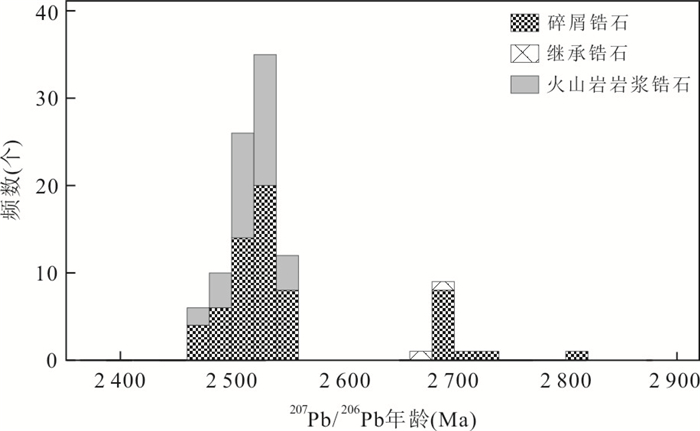
The Wutai Group includes the Shizui,Taihuai and Gaofan subgroups in ascending sequence and has always been considered as Neoarchean strata. However,results from isotopic chronology studies of the Wutai Group have frequently shown a Paleoproterozoic age,making its formation age and stratigraphic subdivision controversial. In this contribution,we have collected all the available isotopic ages obtained from the Wutai Group,including more than 800 groups of zircon U-Pb concordant age. The age dataset indicates that the Gaofan Subgroup,consisting of the Hongsi Formation and the Yangtigou Formation,is no earlier than 2 331±38 Ma and belongs to the Rhyacian Period. The Taihuai Subgroup,consisting of the Baizhiyan and Hongmenyan formations whose deposition ages are constrained 2 435±64 to 2 468±61 Ma and 2 435±64 Ma,respectively,has deposited during 2 435±64 to 2 468±61 Ma,belonging to the Siderian Period of the Paleoproterozoic Era. The Shizui Subgroup is upwardly divided into the Banyukou,Jin'gangku,Zhuangwang and Wenxi formations. The Wenxi and Banyukou formations are lacking of isotopic dating data. The Zhuangwang and Jin'gangku formations are defined to have formed around 2 468±61 Ma and 2 468±61 to 2 494±29 Ma,respectively. This shows that the Shizui Subgroup was formed at the beginning of the Paleoproterozoic Era,i.e.,the lower Siderian Period. Considering that the granitoids in the Wutai granite-greenstone terrain generally yielded zircon U-Pb ages of >2 520 Ma,it is inferred that the Wutai Group was likely deposited on an Archean granitic basement. The zircon U-Pb ages from the Wutai terrain show two peaks around 2.7 Ga and 2.5 Ga,implying two crustal growth events. The island-arc affinity of the 2.52-2.56 Ga granitoids in the Wutai granite-greenstone terrain indicates that plate subduction played an important role in the late Neoarchean.
The Wutai Group includes the Shizui,Taihuai and Gaofan subgroups in ascending sequence and has always been considered as Neoarchean strata. However,results from isotopic chronology studies of the Wutai Group have frequently shown a Paleoproterozoic age,making its formation age and stratigraphic subdivision controversial. In this contribution,we have collected all the available isotopic ages obtained from the Wutai Group,including more than 800 groups of zircon U-Pb concordant age. The age dataset indicates that the Gaofan Subgroup,consisting of the Hongsi Formation and the Yangtigou Formation,is no earlier than 2 331±38 Ma and belongs to the Rhyacian Period. The Taihuai Subgroup,consisting of the Baizhiyan and Hongmenyan formations whose deposition ages are constrained 2 435±64 to 2 468±61 Ma and 2 435±64 Ma,respectively,has deposited during 2 435±64 to 2 468±61 Ma,belonging to the Siderian Period of the Paleoproterozoic Era. The Shizui Subgroup is upwardly divided into the Banyukou,Jin'gangku,Zhuangwang and Wenxi formations. The Wenxi and Banyukou formations are lacking of isotopic dating data. The Zhuangwang and Jin'gangku formations are defined to have formed around 2 468±61 Ma and 2 468±61 to 2 494±29 Ma,respectively. This shows that the Shizui Subgroup was formed at the beginning of the Paleoproterozoic Era,i.e.,the lower Siderian Period. Considering that the granitoids in the Wutai granite-greenstone terrain generally yielded zircon U-Pb ages of >2 520 Ma,it is inferred that the Wutai Group was likely deposited on an Archean granitic basement. The zircon U-Pb ages from the Wutai terrain show two peaks around 2.7 Ga and 2.5 Ga,implying two crustal growth events. The island-arc affinity of the 2.52-2.56 Ga granitoids in the Wutai granite-greenstone terrain indicates that plate subduction played an important role in the late Neoarchean.


2021, 46(1): 13-30.
doi: 10.3799/dqkx.2020.067
Abstract:
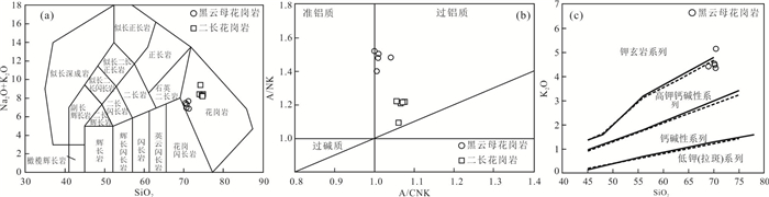
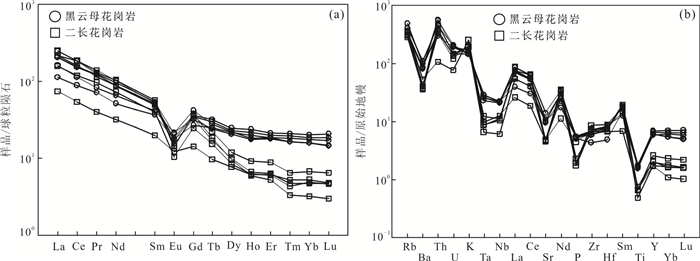
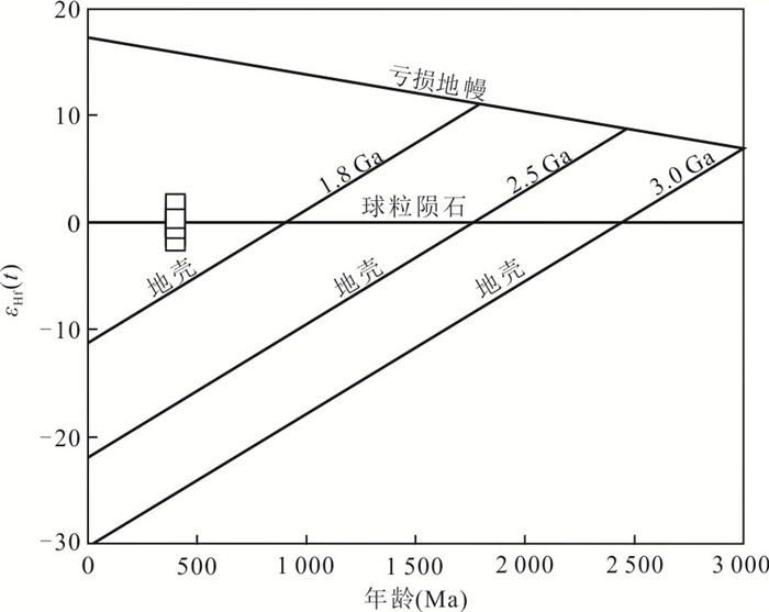
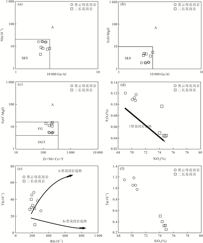
In order to determine the formation time,petrogenesis,magma source and tectonic setting of gneissic biotite granites and the monzonotic granites in the wulanwuzhuer area of Qimantag,East Kunlun.Zircon U-Pb geochronology,geochemistry and HF isotopes of the rocks have been studied.The results show that:The weighted mean age of gneissic biotite granites is 457.5±2.3 Ma,and the A/CNK is between 0.98-1.02,belonging to sub-aluminous rocks.The ratio of Na2O/K2O is between 0.440-0.625,which belongs to high-K calc-alkaline series.The weighted mean age of the Monzonotic granites is 422.5±1.6 Ma,and the A/CNK is between 1.03-1.05,belonging to the weakly peraluminous rocks.Both of them have the characteristics of high SiO2 (SiO2 between 68.93% and 74.72%),high alkali (all alkali ALK between 6.83% and 9.40%),low P2O5 (P2O5 less than 0.12%).Enrichment of LREE and depletion of HREE,and δEu is between 0.29-0.70,indicating that Eu is moderately negative.These samples are enriched in LILE (such as Rb、K) and depleted in HFSE (such as Nb、Ta、P、Ti),belongs to I-type granites.The εHf(t) values of zircon from the monzonotic granites range from -2.2 to +1.4,their Hf two-stage model ages vary from 1.32 Ga to 1.54 Ga.Combined with the geochronological data,geochemical characteristics and regional tectonic evolution,the gneissic biotite granite (457.5±2.3 Ma) is a partial melting product of the lower crust,which was formed in the local tensional environment of the North subduction of the Proto-Tethys.The monzonotic granitic (422.5±1.6 Ma) magma is derived from the partial melting products of the juvenile lower crust in Mesoproterozoic.it is considered that the rocks should be formed in the post-collisional extension setting.
In order to determine the formation time,petrogenesis,magma source and tectonic setting of gneissic biotite granites and the monzonotic granites in the wulanwuzhuer area of Qimantag,East Kunlun.Zircon U-Pb geochronology,geochemistry and HF isotopes of the rocks have been studied.The results show that:The weighted mean age of gneissic biotite granites is 457.5±2.3 Ma,and the A/CNK is between 0.98-1.02,belonging to sub-aluminous rocks.The ratio of Na2O/K2O is between 0.440-0.625,which belongs to high-K calc-alkaline series.The weighted mean age of the Monzonotic granites is 422.5±1.6 Ma,and the A/CNK is between 1.03-1.05,belonging to the weakly peraluminous rocks.Both of them have the characteristics of high SiO2 (SiO2 between 68.93% and 74.72%),high alkali (all alkali ALK between 6.83% and 9.40%),low P2O5 (P2O5 less than 0.12%).Enrichment of LREE and depletion of HREE,and δEu is between 0.29-0.70,indicating that Eu is moderately negative.These samples are enriched in LILE (such as Rb、K) and depleted in HFSE (such as Nb、Ta、P、Ti),belongs to I-type granites.The εHf(t) values of zircon from the monzonotic granites range from -2.2 to +1.4,their Hf two-stage model ages vary from 1.32 Ga to 1.54 Ga.Combined with the geochronological data,geochemical characteristics and regional tectonic evolution,the gneissic biotite granite (457.5±2.3 Ma) is a partial melting product of the lower crust,which was formed in the local tensional environment of the North subduction of the Proto-Tethys.The monzonotic granitic (422.5±1.6 Ma) magma is derived from the partial melting products of the juvenile lower crust in Mesoproterozoic.it is considered that the rocks should be formed in the post-collisional extension setting.


2021, 46(1): 31-42.
doi: 10.3799/dqkx.2019.257
Abstract:
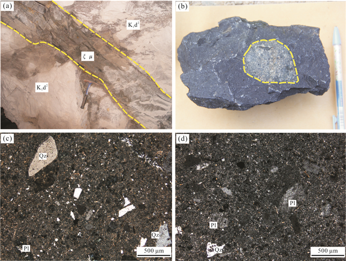
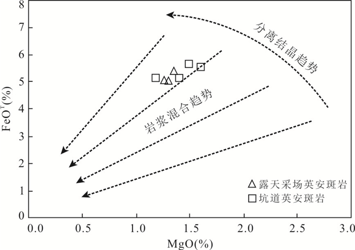
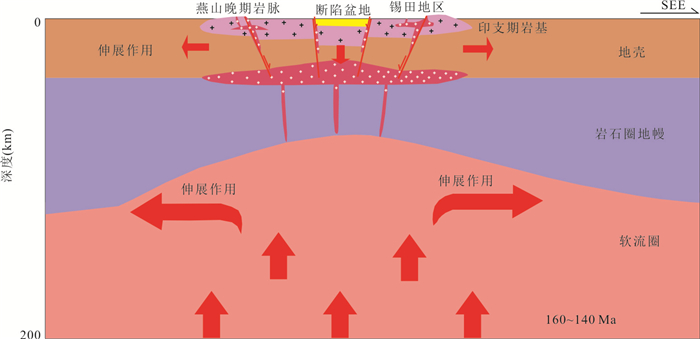
Geochemistry,zircon U-Pb geochronology and Hf isotopic compositions of dacitic porphyry discovered in the Zoujiashan deposit were studied for the first time in Xiangshan uranium deposit. The LA-ICP-MS zircon U-Pb age testing results show that the average weighted age of two samples collected from underground tunnel and open pit were 122.4±0.5 Ma and 126.5±1.4 Ma,respectively,which were formed much later than the large-scale volcanic-intrusive activity. The rock is characterized by negative Eu anomalies,light-heavy REE fractionation,enrichment of large lithophilic elements as well as negative anomalies in Nb and Ta. The zircon εHf(t) values range from -22.0 to 0.2,most of which are concentrated between -6 and -10,and the two-stage Hf model age tDM2 range from 1 170 to 2 575 Ma,which share the similar characteristics with the Xiangshan volcanic rocks and subvolcanic rocks. The trace element and zircon Hf isotopic analysis showed that the dacitic porphyry was mainly derived from partial melting of crust material,but the participation of mantle material could not be ruled out. In combination with previous data,it is believed that the dacitic porphyry and the intermediate-basic dikes were probably formed in the lithospheric extension environment caused by the continuous retreat of the Pacific subduction plate during the Early-Middle Cretaceous period,and were the typical products of the lithospheric thinning in South China.
Geochemistry,zircon U-Pb geochronology and Hf isotopic compositions of dacitic porphyry discovered in the Zoujiashan deposit were studied for the first time in Xiangshan uranium deposit. The LA-ICP-MS zircon U-Pb age testing results show that the average weighted age of two samples collected from underground tunnel and open pit were 122.4±0.5 Ma and 126.5±1.4 Ma,respectively,which were formed much later than the large-scale volcanic-intrusive activity. The rock is characterized by negative Eu anomalies,light-heavy REE fractionation,enrichment of large lithophilic elements as well as negative anomalies in Nb and Ta. The zircon εHf(t) values range from -22.0 to 0.2,most of which are concentrated between -6 and -10,and the two-stage Hf model age tDM2 range from 1 170 to 2 575 Ma,which share the similar characteristics with the Xiangshan volcanic rocks and subvolcanic rocks. The trace element and zircon Hf isotopic analysis showed that the dacitic porphyry was mainly derived from partial melting of crust material,but the participation of mantle material could not be ruled out. In combination with previous data,it is believed that the dacitic porphyry and the intermediate-basic dikes were probably formed in the lithospheric extension environment caused by the continuous retreat of the Pacific subduction plate during the Early-Middle Cretaceous period,and were the typical products of the lithospheric thinning in South China.


2021, 46(1): 43-58.
doi: 10.3799/dqkx.2019.263
Abstract:
In order to determine the fault activity history and its relationship with hydrothermal alteration and W-Sn mineralization,we investigated the field characteristics of the Yanshanian faults in the Xitian ore field and carried out microscopic identification,cathodoluminescence and ore-forming element analysis on quartz in faults. The results show that:(1) The faults are distributed in northern and southern sides of the Chahan basin and dipping to the basin,with striking directions of NE 60°-70°. High dip angles,angular breccias and pectination quartz veins in the faults indicate extensional characteristics. (2) Three stages of magmatic fluid activities occurred in the faults. The stage Ⅰ is characterized by quartz veins occurring as coarse quartz particles (0.5-15.0 mm) with local deformation and fragmentation structures. The stage Ⅱ and stage Ⅲ are typically quartz veins filling in tensile fractures with small quartz particles (0.01-2.00 mm). Moreover,stage Ⅱ quartz develops microcrack structures while stage Ⅲ quartz is idiomorphic and unreformed,suggesting a progressively weakening trend of fault deformation. (3) In contrast to stage Ⅰ and stage Ⅲ mica-free quartz veins,stage Ⅱ quartz veins involve more micas with the high contents of W and Sn elements and minor scheelites and pyrites,which show similar compositional evolutionary characteristics to that of the W-Sn deposits in the Xitian ore field. (4) The distribution of Yanshanian mineralization in the Xitian ore field is closely related to the normal faults,showing clear and regular mineralizing zonation of W-Sn and Pb-Zn deposits from the south to the north on each side of the Chahan Basin. Under the control of extensional tectonic setting of the South China Block during Yanshanian,the comprehensive extension resulting from mantle uplift and remelted magmatic intrusion may be a potential mechanism for the formation of normal faults. The extensional environment of the normal faults was favorable to accumulation of magmatic hydrothermal fluids; and the normal faults provided a channel for the migration of ore-forming hydrothermal fluids.
In order to determine the fault activity history and its relationship with hydrothermal alteration and W-Sn mineralization,we investigated the field characteristics of the Yanshanian faults in the Xitian ore field and carried out microscopic identification,cathodoluminescence and ore-forming element analysis on quartz in faults. The results show that:(1) The faults are distributed in northern and southern sides of the Chahan basin and dipping to the basin,with striking directions of NE 60°-70°. High dip angles,angular breccias and pectination quartz veins in the faults indicate extensional characteristics. (2) Three stages of magmatic fluid activities occurred in the faults. The stage Ⅰ is characterized by quartz veins occurring as coarse quartz particles (0.5-15.0 mm) with local deformation and fragmentation structures. The stage Ⅱ and stage Ⅲ are typically quartz veins filling in tensile fractures with small quartz particles (0.01-2.00 mm). Moreover,stage Ⅱ quartz develops microcrack structures while stage Ⅲ quartz is idiomorphic and unreformed,suggesting a progressively weakening trend of fault deformation. (3) In contrast to stage Ⅰ and stage Ⅲ mica-free quartz veins,stage Ⅱ quartz veins involve more micas with the high contents of W and Sn elements and minor scheelites and pyrites,which show similar compositional evolutionary characteristics to that of the W-Sn deposits in the Xitian ore field. (4) The distribution of Yanshanian mineralization in the Xitian ore field is closely related to the normal faults,showing clear and regular mineralizing zonation of W-Sn and Pb-Zn deposits from the south to the north on each side of the Chahan Basin. Under the control of extensional tectonic setting of the South China Block during Yanshanian,the comprehensive extension resulting from mantle uplift and remelted magmatic intrusion may be a potential mechanism for the formation of normal faults. The extensional environment of the normal faults was favorable to accumulation of magmatic hydrothermal fluids; and the normal faults provided a channel for the migration of ore-forming hydrothermal fluids.


2021, 46(1): 59-72.
doi: 10.3799/dqkx.2019.279
Abstract:
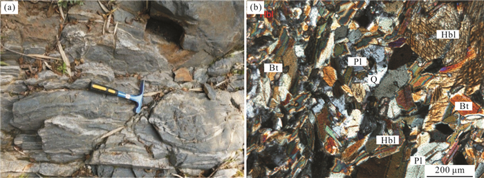
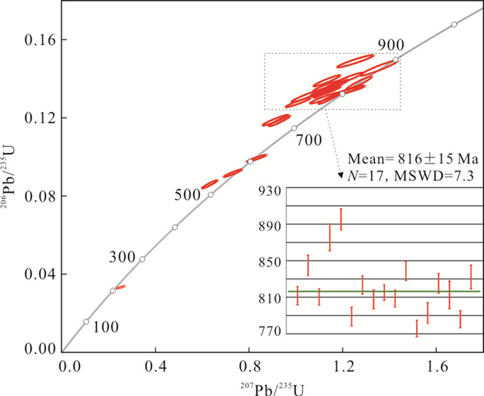
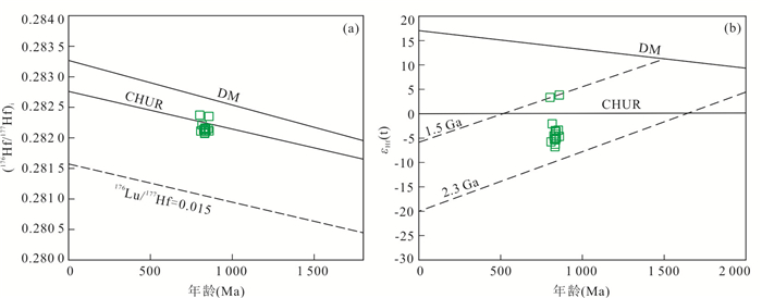
The amphibolites are widespread in the Kangding complex in Miyi-Panzhihua area,south Sichuan. The petrological,geochemical,zircon U-Pb dating and Lu-Hf isotope characteristics from the amphibolites in the Datian area have been studied in this work. The results show that:(1) The SiO2 contents range from 47.88% to 50.05%,falling into the range of subalkaline-alkaline basalt in the discrimination diagrams of TAS and Zr/TiO2-Nb/Y; (2) The total REE contents (ΣREE) range from 121.59×10⁻⁶ to 230.43×10⁻⁶,which is characterized by LREE-rich pattern((La/Yb)N=2.73-7.52) and is similar to oceanic island basalt; (3) The primitive mantle-normalized trace elements spider diagram is similar to that of intra-plate basalt. (4) The ratios of Zr/Nb,Hf/Th indicate that they are similar to intraplate basalt,while have obvious differences with arc basalt; (5) Zircon LA-ICP-MS U-Pb dating demonstrates that the crystallization age of amphiboliteis is 816.0-833.6 Ma,which is contemporary to the large-scale Neoproterozoic mafic magmatism in the west margin of Yangtze block (860-750 Ma),the εHf(t) of zircons is -6.8~+3.8,indicating that the basalts were derived from enriched mantle and has been contaminated by crustal materials. Thus,the amphibolites may formed in the continental rift environment caused by the breakup of Rodinia supercontinent.
The amphibolites are widespread in the Kangding complex in Miyi-Panzhihua area,south Sichuan. The petrological,geochemical,zircon U-Pb dating and Lu-Hf isotope characteristics from the amphibolites in the Datian area have been studied in this work. The results show that:(1) The SiO2 contents range from 47.88% to 50.05%,falling into the range of subalkaline-alkaline basalt in the discrimination diagrams of TAS and Zr/TiO2-Nb/Y; (2) The total REE contents (ΣREE) range from 121.59×10⁻⁶ to 230.43×10⁻⁶,which is characterized by LREE-rich pattern((La/Yb)N=2.73-7.52) and is similar to oceanic island basalt; (3) The primitive mantle-normalized trace elements spider diagram is similar to that of intra-plate basalt. (4) The ratios of Zr/Nb,Hf/Th indicate that they are similar to intraplate basalt,while have obvious differences with arc basalt; (5) Zircon LA-ICP-MS U-Pb dating demonstrates that the crystallization age of amphiboliteis is 816.0-833.6 Ma,which is contemporary to the large-scale Neoproterozoic mafic magmatism in the west margin of Yangtze block (860-750 Ma),the εHf(t) of zircons is -6.8~+3.8,indicating that the basalts were derived from enriched mantle and has been contaminated by crustal materials. Thus,the amphibolites may formed in the continental rift environment caused by the breakup of Rodinia supercontinent.


2021, 46(1): 73-86.
doi: 10.3799/dqkx.2019.258
Abstract:
The age,petrogenesis and geodynamic background of the igneous rock belt across southern Hunan,southern Jiangxi,northern Guangdong and southwestern Fujian,have been controversial in last decades. In this paper,new gabbro samples from Daping of Yongding area in southwestern Fujian are studied to discuss related problems. Based on field work and microscopic petrographical observation,baddeleyite U-Pb isotope age,whole rock major and trace elements content,and Sr-Nd isotoperatios are acquired. The obtained isotopic dating result is 184.0±6.5 Ma,which indicates that the time of magmatism is in early Jurassic. Whole rock data show that these gabbros are high K2O and high K2O+Na2O,no Nb and Ta positive anomalies,(87Sr/86Sr)i value are between 0.708 0 and 0.709 0,εNd(t) value are from -3.6 to -3.0. Geochemistry data prove that gabbro originated from partial melting of enriched lithospheric mantle and had not experienced AFC process. At the same time,there are bimodal volcanic rocks and A-type granites formed in same area,indicating a extension dynamic background in Early Jurassic,enriched lithospheric mantle has EMII characteristics and been heated by the upwelling of as the nosphere mantle,their melts formed Yongding Daping gabbros and Fangkeng Formations basalt respectively.
The age,petrogenesis and geodynamic background of the igneous rock belt across southern Hunan,southern Jiangxi,northern Guangdong and southwestern Fujian,have been controversial in last decades. In this paper,new gabbro samples from Daping of Yongding area in southwestern Fujian are studied to discuss related problems. Based on field work and microscopic petrographical observation,baddeleyite U-Pb isotope age,whole rock major and trace elements content,and Sr-Nd isotoperatios are acquired. The obtained isotopic dating result is 184.0±6.5 Ma,which indicates that the time of magmatism is in early Jurassic. Whole rock data show that these gabbros are high K2O and high K2O+Na2O,no Nb and Ta positive anomalies,(87Sr/86Sr)i value are between 0.708 0 and 0.709 0,εNd(t) value are from -3.6 to -3.0. Geochemistry data prove that gabbro originated from partial melting of enriched lithospheric mantle and had not experienced AFC process. At the same time,there are bimodal volcanic rocks and A-type granites formed in same area,indicating a extension dynamic background in Early Jurassic,enriched lithospheric mantle has EMII characteristics and been heated by the upwelling of as the nosphere mantle,their melts formed Yongding Daping gabbros and Fangkeng Formations basalt respectively.


2021, 46(1): 87-100.
doi: 10.3799/dqkx.2019.014
Abstract:
The Early Mesozoic Zhuendaoouenhuer intrusion is located in Solon Obo area,Inner Mongolia. It mainly consists of hornblende monzonite and monzodiorite.LA-ICP-MS zircon U-Pb dating yields the Early-Triassic age of 248±1 Ma for the hornblende monzonite. Both the hornblende monzonite and monzodiorite are rich in silica (SiO2=51.82%-60.17%),MgO(Mg#=53.17-59.03),alkali (K2O+Na2O=7.36%-9.83%) and Na(K2O/Na2O=0.25-0.53),suggesting a typical alkaline series with the metaluminous feature (A/CNK=0.53-0.75).The rocks are poor in rare earth elements(ΣREE=117.52×10⁻⁶-160.89×10⁻⁶),enriched in LREE[(La/Yb)N=9.57-15.42] and LILEs (Ba、Sr),and depleted in HFSE,especially Nb,Ta,Ti,Y,and insignificant Eu anomalies(δEu=0.76-1.00),and had high Sr,low Y,high Sr/Y ratio,suggesting geochemical characteristics of high-Mg adakite diorite. The combination of geological setting and geochemical characteristics of the Zhuendaoouenhuer high-Mg adakitic rocks were most probably derived from partial melting of the remnant Paleo-Asian oceanicsubducted slabs and subsequently hybridized by mantle peridotite. The formation of the Zhuendaoouenhueradakitic intrusive rocks is related to the extension of the collision between the North China plate and the Siberian plate. These new age and rock geochemical data indicate that the ancient Asian Ocean closed earlier than 248 Ma.
The Early Mesozoic Zhuendaoouenhuer intrusion is located in Solon Obo area,Inner Mongolia. It mainly consists of hornblende monzonite and monzodiorite.LA-ICP-MS zircon U-Pb dating yields the Early-Triassic age of 248±1 Ma for the hornblende monzonite. Both the hornblende monzonite and monzodiorite are rich in silica (SiO2=51.82%-60.17%),MgO(Mg#=53.17-59.03),alkali (K2O+Na2O=7.36%-9.83%) and Na(K2O/Na2O=0.25-0.53),suggesting a typical alkaline series with the metaluminous feature (A/CNK=0.53-0.75).The rocks are poor in rare earth elements(ΣREE=117.52×10⁻⁶-160.89×10⁻⁶),enriched in LREE[(La/Yb)N=9.57-15.42] and LILEs (Ba、Sr),and depleted in HFSE,especially Nb,Ta,Ti,Y,and insignificant Eu anomalies(δEu=0.76-1.00),and had high Sr,low Y,high Sr/Y ratio,suggesting geochemical characteristics of high-Mg adakite diorite. The combination of geological setting and geochemical characteristics of the Zhuendaoouenhuer high-Mg adakitic rocks were most probably derived from partial melting of the remnant Paleo-Asian oceanicsubducted slabs and subsequently hybridized by mantle peridotite. The formation of the Zhuendaoouenhueradakitic intrusive rocks is related to the extension of the collision between the North China plate and the Siberian plate. These new age and rock geochemical data indicate that the ancient Asian Ocean closed earlier than 248 Ma.


2021, 46(1): 101-121.
doi: 10.3799/dqkx.2019.259
Abstract:
The northern Alxa block is the key area for studying the closing of the Paleo-Asian Ocean,whereas the Permo-Carboniferous igneous in this area have been rarely investigated,leading to the time and way of the closing of the Paleo-Asian Ocean can not be unified directly,and more importantly,restricting a deeper insight into the tectonic evolution of the central southern Altaids in late Paleozoic.In this paper,we carried out a systematic study of the petrography,whole rock geochemistry,zircon U-Pb dating for the Wuliji intrusions,which are located in the Shalazhashan structural belt that spreading between the Engewusu fault belt and Badanjilin fault belt.Our results demonstrated that the Wuliji intrusions are mainly composed of granodiorite and granite,the weighted average ages of two samples from granodiorite are 266.00±1.00 Ma(MSWD=0.69)、267.76±0.97 Ma(MSWD=0.26),and the weighted average ages of three samples from granite are 254.57±0.99 Ma(MSWD=0.79)、253.70±1.70 Ma(MSWD=2.50)、252.50±2.90 Ma(MSWD=4.70). The SiO2 contents of the granodiorite are between 64.13%-67.17%,while the granite are between 68.08%-75.29%,the Na2O+K2O contents of the granodiorite are between 6.40%-7.00%,while the granite are between 7.09%-7.94%,both are I-type granites with medium degree of differentiation. They are depleted in Nb、Ta、P、Ti and HREEs,but relatively enriched in K、Zr、Hf and LREEs,the total content rations of LREE and HREE are between 6.49-17.45 and the fractionation of the HREEs is obvious. The (La/Yb)N values of granodiorite are between 6.21-8.80,while the granite are between 9.21-22.06. Geochemistry shows that the two stages intrusions were resulted from crust-mantle interaction with the crust as the major magmatic source and the separate crystallization,fluid metasomatism. The geological,elemental and isotopic evidences show that the Paleo-Asian Ocean maybe closed in Pre-Permian,and the Alxa was in-board evolution since Permian,the Wuliji area was under the transformation phase from regional syn-orogenic squeeze to post-orogenic extension or post-collision extension phase.
The northern Alxa block is the key area for studying the closing of the Paleo-Asian Ocean,whereas the Permo-Carboniferous igneous in this area have been rarely investigated,leading to the time and way of the closing of the Paleo-Asian Ocean can not be unified directly,and more importantly,restricting a deeper insight into the tectonic evolution of the central southern Altaids in late Paleozoic.In this paper,we carried out a systematic study of the petrography,whole rock geochemistry,zircon U-Pb dating for the Wuliji intrusions,which are located in the Shalazhashan structural belt that spreading between the Engewusu fault belt and Badanjilin fault belt.Our results demonstrated that the Wuliji intrusions are mainly composed of granodiorite and granite,the weighted average ages of two samples from granodiorite are 266.00±1.00 Ma(MSWD=0.69)、267.76±0.97 Ma(MSWD=0.26),and the weighted average ages of three samples from granite are 254.57±0.99 Ma(MSWD=0.79)、253.70±1.70 Ma(MSWD=2.50)、252.50±2.90 Ma(MSWD=4.70). The SiO2 contents of the granodiorite are between 64.13%-67.17%,while the granite are between 68.08%-75.29%,the Na2O+K2O contents of the granodiorite are between 6.40%-7.00%,while the granite are between 7.09%-7.94%,both are I-type granites with medium degree of differentiation. They are depleted in Nb、Ta、P、Ti and HREEs,but relatively enriched in K、Zr、Hf and LREEs,the total content rations of LREE and HREE are between 6.49-17.45 and the fractionation of the HREEs is obvious. The (La/Yb)N values of granodiorite are between 6.21-8.80,while the granite are between 9.21-22.06. Geochemistry shows that the two stages intrusions were resulted from crust-mantle interaction with the crust as the major magmatic source and the separate crystallization,fluid metasomatism. The geological,elemental and isotopic evidences show that the Paleo-Asian Ocean maybe closed in Pre-Permian,and the Alxa was in-board evolution since Permian,the Wuliji area was under the transformation phase from regional syn-orogenic squeeze to post-orogenic extension or post-collision extension phase.


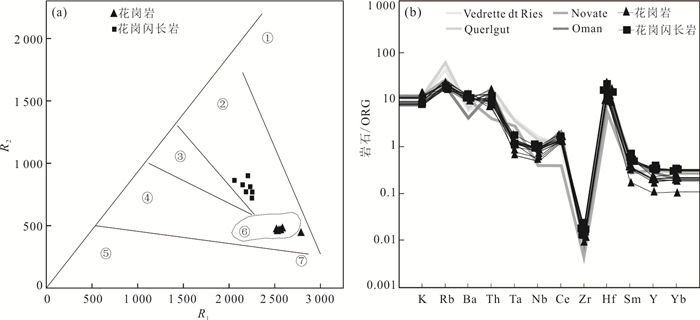
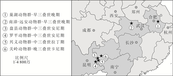
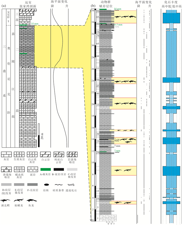
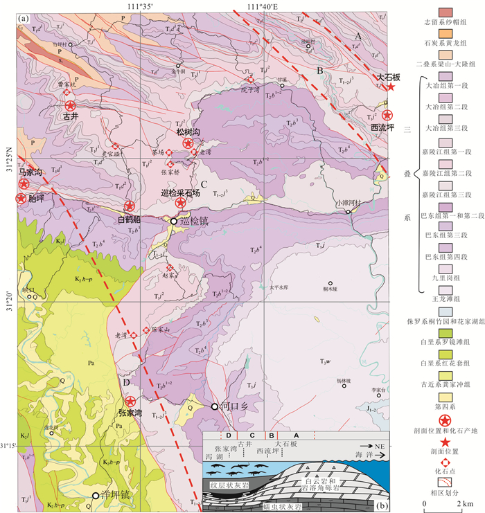
2021, 46(1): 122-135.
doi: 10.3799/dqkx.2020.023
Abstract:
Based on the study of fossils spots and representative sections of the Nanzhang-Yuan'an Fauna, especially the Zhangjiawan section in Yuan'an county, the lithostratigraphic characteristics of the Jialingjiang Formation was redefined between Nanzhang and Yuan'an areas. It is reasonable that the Jialingjiang Formation in those areas should be divided into three members, in which the Nanzhang-Yuan'an Fauna is mainly yielded in the upper part of Member II. The lithology yielded the Nanzhang-Yuan'an Fauna mainly consists of laminated micritic limestone intercalated with normal micrite. Through systematical fossil excavations and detailed descriptions of the Zhangjiawan section, the vertical stratigraphic distributions of the Nanzhang-Yuan'an Fauna are preliminary recognized. Marine reptile fossils could exist in almost whole strata of the upper part of Member II of the Jialingjiang Formation, but the fossil abundance and diversity change largely in different layers. The abundance and diversity are relatively higher in seven strata assemblages than others, the peak appeared at the uppermost assemblages. The horizontal paleogeographic distribution features of the fauna in those areas could be summarized as four facies belts, named A, B, C and D zones, which correspond to empty zone, marginal zone, relative enrichment zone and enrichment zone, respectively. Different zones reflect the fauna experienced from rare to rich, meanwhile the water depth gradually deepens from northeast to southwest. The distributions of the Nanzhang-Yuan'an Fauna indicate that the marine reptiles could live in restricted shallow water or lagoon environment. The research will lay a good foundation not only for the co-evolution between early marine reptiles and environment, but also for its response to the Early Triassic biological recovery.
Based on the study of fossils spots and representative sections of the Nanzhang-Yuan'an Fauna, especially the Zhangjiawan section in Yuan'an county, the lithostratigraphic characteristics of the Jialingjiang Formation was redefined between Nanzhang and Yuan'an areas. It is reasonable that the Jialingjiang Formation in those areas should be divided into three members, in which the Nanzhang-Yuan'an Fauna is mainly yielded in the upper part of Member II. The lithology yielded the Nanzhang-Yuan'an Fauna mainly consists of laminated micritic limestone intercalated with normal micrite. Through systematical fossil excavations and detailed descriptions of the Zhangjiawan section, the vertical stratigraphic distributions of the Nanzhang-Yuan'an Fauna are preliminary recognized. Marine reptile fossils could exist in almost whole strata of the upper part of Member II of the Jialingjiang Formation, but the fossil abundance and diversity change largely in different layers. The abundance and diversity are relatively higher in seven strata assemblages than others, the peak appeared at the uppermost assemblages. The horizontal paleogeographic distribution features of the fauna in those areas could be summarized as four facies belts, named A, B, C and D zones, which correspond to empty zone, marginal zone, relative enrichment zone and enrichment zone, respectively. Different zones reflect the fauna experienced from rare to rich, meanwhile the water depth gradually deepens from northeast to southwest. The distributions of the Nanzhang-Yuan'an Fauna indicate that the marine reptiles could live in restricted shallow water or lagoon environment. The research will lay a good foundation not only for the co-evolution between early marine reptiles and environment, but also for its response to the Early Triassic biological recovery.


2021, 46(1): 136-147.
doi: 10.3799/dqkx.2019.284
Abstract:
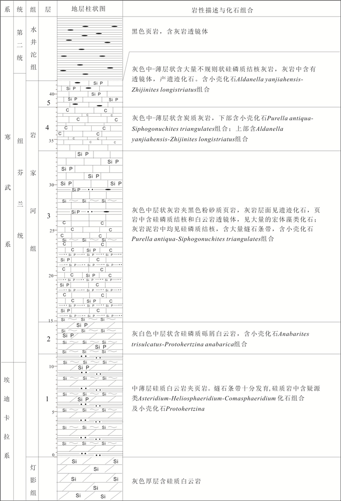
This paper is focused on the base of the Fortunian and Cambrian Stage 2 in the Gunziao section of Yichang, Hubei province. Thousands of SSFs has been found by dealing with 61 samples, 23 genera and 44 species to be identified and described. Additionally, some conclusions are drawn as follows. According to the first appearance datum of Asteridium and Protohertzina sp., and the large negative carbon isotope anomaly (BACE), the base of the Fortunian should be located at 10.5 meters above the Beds 1. According to the first appearance datum of Zhijinites longistriatus and the large positive carbon isotope anomaly (ZHUCE), it can be inferred that the base of Stage 2 is approximately 2.78 meters above the Beds 4. Purella antiqua Assemblage Zone (ZoneⅡ) and Aldanella yanjiahensis Assemblage Zone (ZoneⅢ) in Three Gorge area are redefined based on the new data, which is to be Purella antiqua-Siphogonuchites triangularis Assemblage Zone and Aldanella yanjiahensis-Zhijinites longistriatus Assemblage Zone.
This paper is focused on the base of the Fortunian and Cambrian Stage 2 in the Gunziao section of Yichang, Hubei province. Thousands of SSFs has been found by dealing with 61 samples, 23 genera and 44 species to be identified and described. Additionally, some conclusions are drawn as follows. According to the first appearance datum of Asteridium and Protohertzina sp., and the large negative carbon isotope anomaly (BACE), the base of the Fortunian should be located at 10.5 meters above the Beds 1. According to the first appearance datum of Zhijinites longistriatus and the large positive carbon isotope anomaly (ZHUCE), it can be inferred that the base of Stage 2 is approximately 2.78 meters above the Beds 4. Purella antiqua Assemblage Zone (ZoneⅡ) and Aldanella yanjiahensis Assemblage Zone (ZoneⅢ) in Three Gorge area are redefined based on the new data, which is to be Purella antiqua-Siphogonuchites triangularis Assemblage Zone and Aldanella yanjiahensis-Zhijinites longistriatus Assemblage Zone.


2021, 46(1): 148-161.
doi: 10.3799/dqkx.2019.245
Abstract:
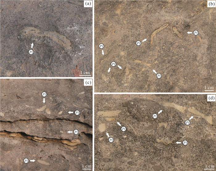
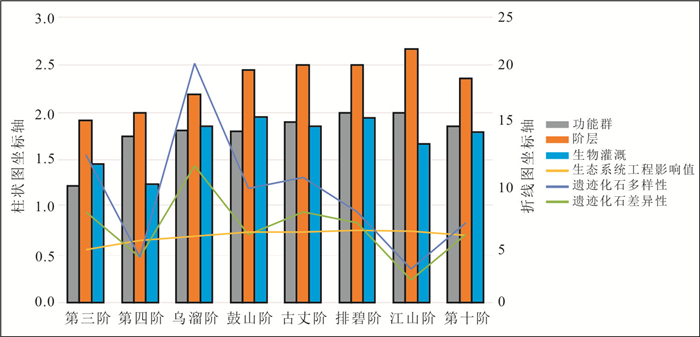
The bioturbators, which are ecosystem engineers, act on the interaction between sediments and water (the circulation, migration and storage of nutrients) through the reworking of sediments directly. As a result, they have an significant impact on benthic ecosystems engineering. The trace fossils provide evidence for studying the evolution of ecosystem engineers and assessing the impact of engineers on ecosystem engineering after the Cambrian explosion, as they provide records for activities of benthic organism. This paper studies benthic ecosystem engineers from three aspects-functional group, tiering and biological irrigation, by applying the modern biology concept of 'ecosystem engineering impact'. Statistics on the trace fossils of eight Cambrian sections in Henan Province show that the functional group types of the ecosystem engineers have changed from biodiffusive bioturbators to upward/downward conveyors, infaunal tier has gotten deeper, biological irrigation has became more common, and the ecosystem engineering impact has been increasing from Stage 3 to Drumian. But the type and structure of trace fossils have no changes, and the ecosystem engineering impact tends to be stable from Drumian to the Stage 10.This means that the behavioral strategy of benthic ecosystem engineer sevolve and innovate obviously during the time from the ending of the Cambrian Explosion to Drumian, by expanding ecospaces and creating new habitats for other macrobiotic and microbiotic organisms. In a word, these ecosystem engineers played an important role in the Cambrian marine ecosystem.
The bioturbators, which are ecosystem engineers, act on the interaction between sediments and water (the circulation, migration and storage of nutrients) through the reworking of sediments directly. As a result, they have an significant impact on benthic ecosystems engineering. The trace fossils provide evidence for studying the evolution of ecosystem engineers and assessing the impact of engineers on ecosystem engineering after the Cambrian explosion, as they provide records for activities of benthic organism. This paper studies benthic ecosystem engineers from three aspects-functional group, tiering and biological irrigation, by applying the modern biology concept of 'ecosystem engineering impact'. Statistics on the trace fossils of eight Cambrian sections in Henan Province show that the functional group types of the ecosystem engineers have changed from biodiffusive bioturbators to upward/downward conveyors, infaunal tier has gotten deeper, biological irrigation has became more common, and the ecosystem engineering impact has been increasing from Stage 3 to Drumian. But the type and structure of trace fossils have no changes, and the ecosystem engineering impact tends to be stable from Drumian to the Stage 10.This means that the behavioral strategy of benthic ecosystem engineer sevolve and innovate obviously during the time from the ending of the Cambrian Explosion to Drumian, by expanding ecospaces and creating new habitats for other macrobiotic and microbiotic organisms. In a word, these ecosystem engineers played an important role in the Cambrian marine ecosystem.


Division and Age of the Upper Jurassic Mandetou Orbo Formation in Central and Eastern Inner Mongolia
2021, 46(1): 162-171.
doi: 10.3799/dqkx.2020.248
Abstract:
The volcanic rocks in Manketou'ebo Formation, located in the middle east area of Inner Mongolia, are mainly composed of rhyolitic pyroclastic rocks, mixed with intermountain lacustrine facies continental clastic rocks and a small amount of rhyolite or dacite. Sedimentary rocks contain fossils of Estherians (Magumbonia paramecia, Nestoria reticulate, N. xishunjingensis, N. cf. pissoui, Lioestheria sp.), Bivalves (Ferganoconcha curta, F. subcentralis, F. elongate) and vegetation (Ginkgoites sp., Cladophlebis sp., Lycopodites sp., Baiera gracilis, Phoenicopsis sp.). Geochemical study shows that the chemical constitutes of these fossils are SiO2 71.47%-75.96%, Ai2O3 12.50%-14.18%, K2O 3.84%-4.98%, Na2O 3.22%-4.14% and ALK 7.84%-9.12%, indicating richness in silicon and alkali. In terms of trace elements, all specimens are characterized by high ratio of Rb, K, Th, U, La and LREE, and lack of Ba, Nb, Sr, P and Ti. Rare earth element ΣREE ranges from 118.71×10⁻⁶ to 189.99×10⁻⁶; significant fractionation of HREE and LREE ((La/Yb)N=4.79-25.56) and moderate negative Eu anomalies (δEu=0.05-0.61) are detected. All 4 specimens, on the basis of the logδ-logτ diagram, are classified into orogenic belt mountain granite area. Meanwhile according to the Rb-Y+Nb diagram, these specimens belong to volcanic arc granite area, and the Nb-Y diagram suggests 4 specimens pertain to the same volcanic arc granite with collision granite area. The ages of 4 zircon LA-MC-IC-MS isotope samples collected from Abagaqi-Zarutqi-Bahrainyouqi are respectively 138.89±0.93 Ma, 137.70±1.40 Ma, 147.70±1.20 Ma and 137.27±0.96 Ma, which therefore suggests that the era of Manketou'ebo Formation lies between Late Jurassic and Early Cretaceous.
The volcanic rocks in Manketou'ebo Formation, located in the middle east area of Inner Mongolia, are mainly composed of rhyolitic pyroclastic rocks, mixed with intermountain lacustrine facies continental clastic rocks and a small amount of rhyolite or dacite. Sedimentary rocks contain fossils of Estherians (Magumbonia paramecia, Nestoria reticulate, N. xishunjingensis, N. cf. pissoui, Lioestheria sp.), Bivalves (Ferganoconcha curta, F. subcentralis, F. elongate) and vegetation (Ginkgoites sp., Cladophlebis sp., Lycopodites sp., Baiera gracilis, Phoenicopsis sp.). Geochemical study shows that the chemical constitutes of these fossils are SiO2 71.47%-75.96%, Ai2O3 12.50%-14.18%, K2O 3.84%-4.98%, Na2O 3.22%-4.14% and ALK 7.84%-9.12%, indicating richness in silicon and alkali. In terms of trace elements, all specimens are characterized by high ratio of Rb, K, Th, U, La and LREE, and lack of Ba, Nb, Sr, P and Ti. Rare earth element ΣREE ranges from 118.71×10⁻⁶ to 189.99×10⁻⁶; significant fractionation of HREE and LREE ((La/Yb)N=4.79-25.56) and moderate negative Eu anomalies (δEu=0.05-0.61) are detected. All 4 specimens, on the basis of the logδ-logτ diagram, are classified into orogenic belt mountain granite area. Meanwhile according to the Rb-Y+Nb diagram, these specimens belong to volcanic arc granite area, and the Nb-Y diagram suggests 4 specimens pertain to the same volcanic arc granite with collision granite area. The ages of 4 zircon LA-MC-IC-MS isotope samples collected from Abagaqi-Zarutqi-Bahrainyouqi are respectively 138.89±0.93 Ma, 137.70±1.40 Ma, 147.70±1.20 Ma and 137.27±0.96 Ma, which therefore suggests that the era of Manketou'ebo Formation lies between Late Jurassic and Early Cretaceous.


2021, 46(1): 172-185.
doi: 10.3799/dqkx.2019.249
Abstract:
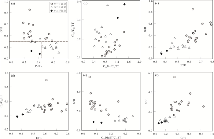
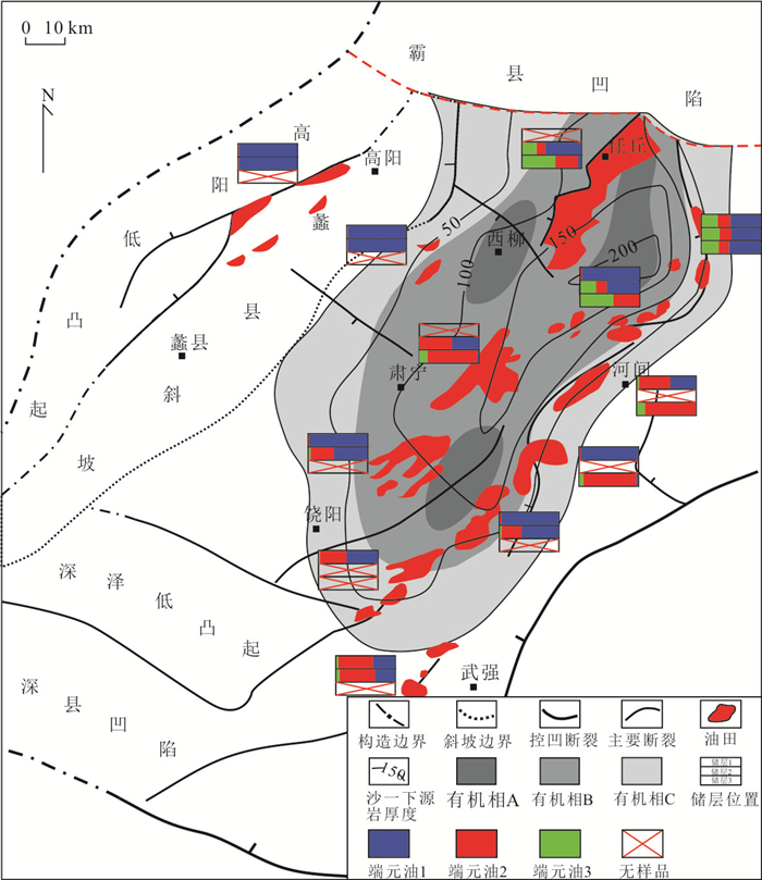
In order to study the geochemical characteristics and accumulation contribution of a high-quality source rock, lower sub-member of the first member of the Shahejie Formation (E2s1L), in Raoyang depression. Based on experimental data of TOC, pyrolysis, hydrocarbon generation simulation, the hydrocarbon generation potential of source rocks was evaluated, and in combination with GC-MS experimental data and the result of hydrocarbon generation evaluation, molecular geochemical characteristics and organic phase characteristics were described. Furthermore, by using multi-dimensional statistical methods, oil-rock correlation was established, and the contribution rate of each source rock was quantified as well as the law of accumulation contribution of E2s1L was summarized. The research indicates that the hydrocarbon generation potential of the E2s1L is the highest among the three developed sets of source rocks. The biomarker parameters such as gammacerane-C30hopane ratio, sterane-hopane ratio are significantly different from the other two sets of source rocks. The crude oil samples were divided into three types, including E2s3 type, mixed type derived from E2s3 and E2s1L, and E2s1L type. The bulk contribution rate of the E2s1L in the Raoyang Depression reaches 58%. The E2s1L source rock in the Raoyang sag is a high-quality source rock, which has a great contribution to the oil accumulation of the Raoyang depression and should get paid more attention. The high contribution areas of are controlled by geological conditions and accumulation models, and also controlled by source rock organic facies. Crude oil reserves in the Paleogene and Neogene reservoirs is primarily contributed by the E2s1L.
In order to study the geochemical characteristics and accumulation contribution of a high-quality source rock, lower sub-member of the first member of the Shahejie Formation (E2s1L), in Raoyang depression. Based on experimental data of TOC, pyrolysis, hydrocarbon generation simulation, the hydrocarbon generation potential of source rocks was evaluated, and in combination with GC-MS experimental data and the result of hydrocarbon generation evaluation, molecular geochemical characteristics and organic phase characteristics were described. Furthermore, by using multi-dimensional statistical methods, oil-rock correlation was established, and the contribution rate of each source rock was quantified as well as the law of accumulation contribution of E2s1L was summarized. The research indicates that the hydrocarbon generation potential of the E2s1L is the highest among the three developed sets of source rocks. The biomarker parameters such as gammacerane-C30hopane ratio, sterane-hopane ratio are significantly different from the other two sets of source rocks. The crude oil samples were divided into three types, including E2s3 type, mixed type derived from E2s3 and E2s1L, and E2s1L type. The bulk contribution rate of the E2s1L in the Raoyang Depression reaches 58%. The E2s1L source rock in the Raoyang sag is a high-quality source rock, which has a great contribution to the oil accumulation of the Raoyang depression and should get paid more attention. The high contribution areas of are controlled by geological conditions and accumulation models, and also controlled by source rock organic facies. Crude oil reserves in the Paleogene and Neogene reservoirs is primarily contributed by the E2s1L.


2021, 46(1): 186-199.
doi: 10.3799/dqkx.2019.283
Abstract:
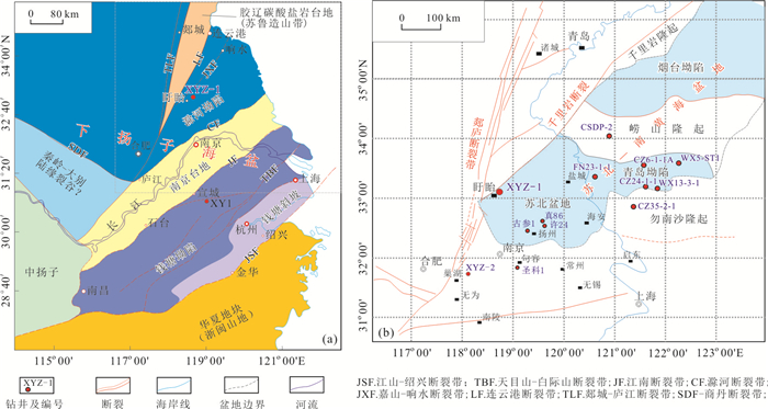
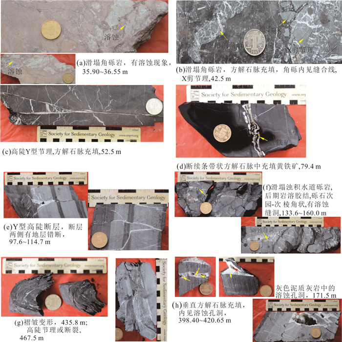
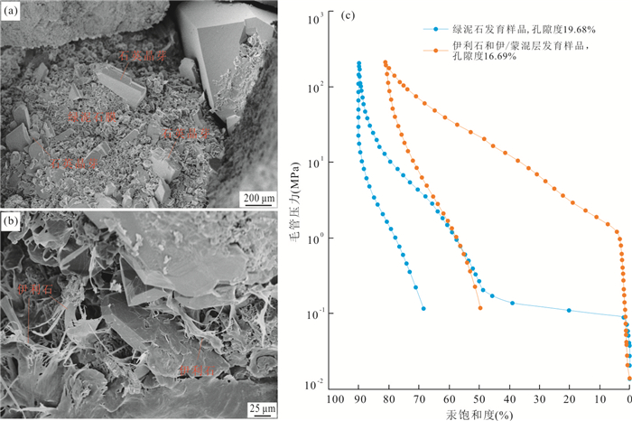
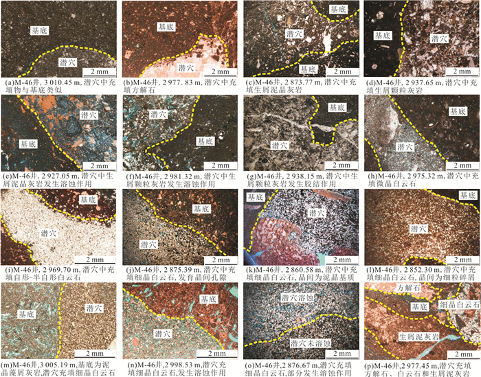
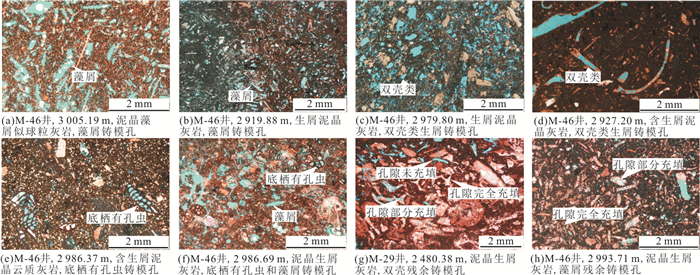
The study of sedimentology and pore structure of black fine-grained sedimentary rock series is of great significance for environment, shale gas reservoir evaluation and favorable reservoir prediction.Using the newly drilled XYZ-1 well data in the Lower Yangtze area, based on systematic coring identification of Lower Cambrian Mufushan Formation, rock thin section, XRD (X-Ray Diffraction) analysis, and argon ion-field emission-scanning electron microscopy (Ar-FE-SEM), the sedimentology and pore structures of the fine-grained deposits series arestudied in this study.The results show that the lithologic composition of the Mufushan Formation is dominated by dark (carbonaceous) mudstone, light gray argillaceous limestone and cryptite, interbeded with marl, dolomitic limestone, terrigenouslimestone and dolomite, Andesite, breccia, etc., mainly composed of siliceous clay-mixed shale facies and siliceous clay-like shale facies. It is belong to the continental shelfshallow-sea carbonate platform-deep-water bay-tidal flat environment of the lower Yangtze ocean basin.The black argillutite (mud shale) of the Mufushan Formation has various pore types, the organic pores are 2-200 nm, the surface porosity ratio is 2.86%-15.90%, the pore distribution is relatively uniform, but the overall connectivity is poor, and some organic pores are inhomogeneity symbiotic with the brittle mineral or clay mineral. The inorganic pores are mainly intragranular, intergranular pores and dissolution pores, and some are intercrystalline pores and intermetallic pores. Except for the intercrystalline pores of pyrite, most of the inorganic pores are larger than 2 μm and the maximum is 50 μm.The micro-cracks in the shale are widely developed, and the micro-cracks of tectonic origin are complex in shape, and the slit width is generally 20-500 μm, generally filled with calcite and quartz. The length of diagenetic micro-cracks is generally greater than 10μm and the slit width is 50 to 200 nm. The black mud shale in the upper deep-water bay facies and lower parts of the mud flat and evaporate plat form of the Mufushan Formation has favorable conditions for the development of high quality shale gas reservoirs, due to a high TOC content from 2.65%-21.27%, average 6.30%, organic-inorganic pore system, and fracture system development, high clay minerals and brittle minerals content.
The study of sedimentology and pore structure of black fine-grained sedimentary rock series is of great significance for environment, shale gas reservoir evaluation and favorable reservoir prediction.Using the newly drilled XYZ-1 well data in the Lower Yangtze area, based on systematic coring identification of Lower Cambrian Mufushan Formation, rock thin section, XRD (X-Ray Diffraction) analysis, and argon ion-field emission-scanning electron microscopy (Ar-FE-SEM), the sedimentology and pore structures of the fine-grained deposits series arestudied in this study.The results show that the lithologic composition of the Mufushan Formation is dominated by dark (carbonaceous) mudstone, light gray argillaceous limestone and cryptite, interbeded with marl, dolomitic limestone, terrigenouslimestone and dolomite, Andesite, breccia, etc., mainly composed of siliceous clay-mixed shale facies and siliceous clay-like shale facies. It is belong to the continental shelfshallow-sea carbonate platform-deep-water bay-tidal flat environment of the lower Yangtze ocean basin.The black argillutite (mud shale) of the Mufushan Formation has various pore types, the organic pores are 2-200 nm, the surface porosity ratio is 2.86%-15.90%, the pore distribution is relatively uniform, but the overall connectivity is poor, and some organic pores are inhomogeneity symbiotic with the brittle mineral or clay mineral. The inorganic pores are mainly intragranular, intergranular pores and dissolution pores, and some are intercrystalline pores and intermetallic pores. Except for the intercrystalline pores of pyrite, most of the inorganic pores are larger than 2 μm and the maximum is 50 μm.The micro-cracks in the shale are widely developed, and the micro-cracks of tectonic origin are complex in shape, and the slit width is generally 20-500 μm, generally filled with calcite and quartz. The length of diagenetic micro-cracks is generally greater than 10μm and the slit width is 50 to 200 nm. The black mud shale in the upper deep-water bay facies and lower parts of the mud flat and evaporate plat form of the Mufushan Formation has favorable conditions for the development of high quality shale gas reservoirs, due to a high TOC content from 2.65%-21.27%, average 6.30%, organic-inorganic pore system, and fracture system development, high clay minerals and brittle minerals content.


2021, 46(1): 200-214.
doi: 10.3799/dqkx.2019.282
Abstract:
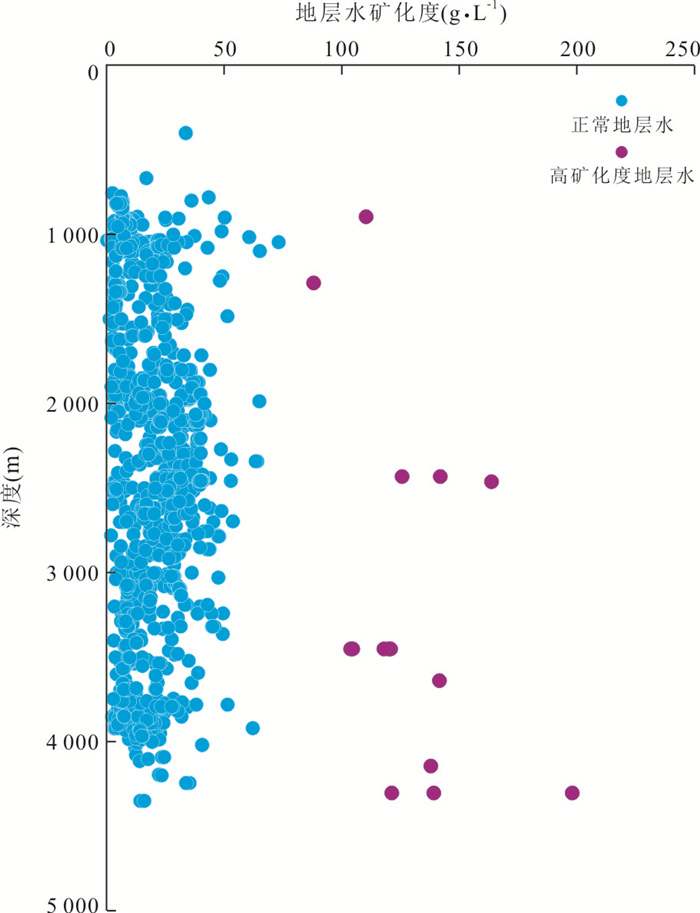
In order to clarify the development characteristics of the hydrothermal fluid activity and its reformation effect on the reservoir in the oil-rich depression, the Qikou depression in the Bohai Bay basin was studied. Based on the analysis of core, thin sections, XRF, SEM, salinity of formation water, pyrolysis, homogenization temperature of inclusions, clay minerals, trace elements, REE and conventional physical properties, the evidences of hydrothermal fluid activity in Qikou depression of Bohai Bay basin were analyzed, and the reformation patterns on different types of reservoirs were identified. we regard that the hydrothermal fluid activity in the Qikou depression is relatively developed and has a strong reformation effect on the reservoir. The results show that there are several types of hydrothermal fluid activity indicators in the Qikou depression, including:hydrothermal breccia, zebra fabric, faded mudstone and several kinds of hydrothermal mineral associations; abnormally high formation water salinity; mudstones with abnormally high Tmax or S1 and S2 values; the homogenization temperature of inclusion exceeding the maximum temperature of normal thermal evolution; the abnormally high content of kaolinite in shallow strata sandstones and the abnormally high content of chlorite in mid-deep strata sandstones; the abnormally high characteristics of trace elements such as Zn、Cd、Ba and Pb in mudstones; the rare earth elements in carbonate rocks showing Eu positive anomaly. In different kinds of reservoirs, the reformation patterns of hydrothermal fluid are different:hydraulic fracturing and dissolution are mainly developed in the carbonate rocks, hydraulic fracturing and promoting devitrification are mainly developed in the tuff, hydraulic fracturing is mainly developed in the basalt, while the hydrothermal fluid reform sandstone reservoirs by dissolution and promoting chlorite development.
In order to clarify the development characteristics of the hydrothermal fluid activity and its reformation effect on the reservoir in the oil-rich depression, the Qikou depression in the Bohai Bay basin was studied. Based on the analysis of core, thin sections, XRF, SEM, salinity of formation water, pyrolysis, homogenization temperature of inclusions, clay minerals, trace elements, REE and conventional physical properties, the evidences of hydrothermal fluid activity in Qikou depression of Bohai Bay basin were analyzed, and the reformation patterns on different types of reservoirs were identified. we regard that the hydrothermal fluid activity in the Qikou depression is relatively developed and has a strong reformation effect on the reservoir. The results show that there are several types of hydrothermal fluid activity indicators in the Qikou depression, including:hydrothermal breccia, zebra fabric, faded mudstone and several kinds of hydrothermal mineral associations; abnormally high formation water salinity; mudstones with abnormally high Tmax or S1 and S2 values; the homogenization temperature of inclusion exceeding the maximum temperature of normal thermal evolution; the abnormally high content of kaolinite in shallow strata sandstones and the abnormally high content of chlorite in mid-deep strata sandstones; the abnormally high characteristics of trace elements such as Zn、Cd、Ba and Pb in mudstones; the rare earth elements in carbonate rocks showing Eu positive anomaly. In different kinds of reservoirs, the reformation patterns of hydrothermal fluid are different:hydraulic fracturing and dissolution are mainly developed in the carbonate rocks, hydraulic fracturing and promoting devitrification are mainly developed in the tuff, hydraulic fracturing is mainly developed in the basalt, while the hydrothermal fluid reform sandstone reservoirs by dissolution and promoting chlorite development.


2021, 46(1): 215-227.
doi: 10.3799/dqkx.2020.255
Abstract:
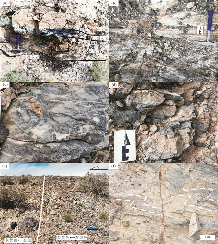
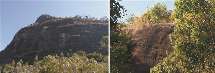
Paleoseamounts are key components of suture zones. In the Tianshan orogen located in the southwestern segment of the Central Asian Orogenic Belt, many paleoseamounts have been reported, while few were discovered in the Beishan orogen. Discovery of a paleoseamount can compensate for the lack of studies on seamounts in the Beishan orogen. After geological survey on the Yemaquan area in central Beishan orogen and measuring a profile, strata composed of basalts, basaltic tuffites and marbles with primitive sequences were discovered. The strata contain volcanic basement and carbonate cap, and the two segments primitively conformably contacted, indicating that the strata are fragments of a paleoseamount. The sedimentary structures and rock associations of the paleoseamount in the Yemaquan area indicate that they were deposited in a seamount slope. The seamount fragment in this study trends NWW-SEE and the southeastern part approaches the seamount top. The basalts in the seamount are enriched in large iron lithophile elements and depleted in high field strength elements, showing characteristics of island arc basalts. The seamount in this study is an oceanic arc type seamount. The rocks in the Yemaquan area were deposited in seamount slope facies and trended NWW-SEE after they were dismembered.
Paleoseamounts are key components of suture zones. In the Tianshan orogen located in the southwestern segment of the Central Asian Orogenic Belt, many paleoseamounts have been reported, while few were discovered in the Beishan orogen. Discovery of a paleoseamount can compensate for the lack of studies on seamounts in the Beishan orogen. After geological survey on the Yemaquan area in central Beishan orogen and measuring a profile, strata composed of basalts, basaltic tuffites and marbles with primitive sequences were discovered. The strata contain volcanic basement and carbonate cap, and the two segments primitively conformably contacted, indicating that the strata are fragments of a paleoseamount. The sedimentary structures and rock associations of the paleoseamount in the Yemaquan area indicate that they were deposited in a seamount slope. The seamount fragment in this study trends NWW-SEE and the southeastern part approaches the seamount top. The basalts in the seamount are enriched in large iron lithophile elements and depleted in high field strength elements, showing characteristics of island arc basalts. The seamount in this study is an oceanic arc type seamount. The rocks in the Yemaquan area were deposited in seamount slope facies and trended NWW-SEE after they were dismembered.


2021, 46(1): 228-241.
doi: 10.3799/dqkx.2019.281
Abstract:
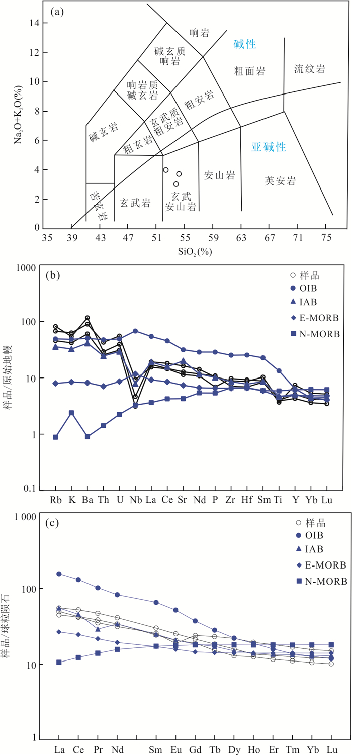
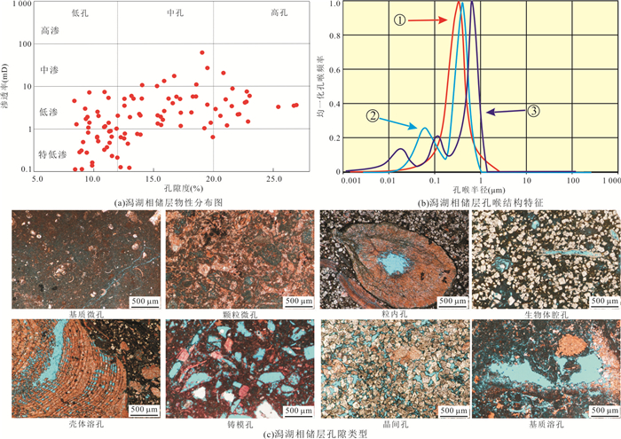
In order to understand the genesis of reservoir heterogeneity in lagoon, based on core, reservoir physical property data, cast thin section and mercury injection experiment, the characteristics and genetic mechanism of reservoir of lagoon facies in the Mishrif Formation in M oilfield were studied. The results showed that the reservoirs of lagoon facies were diversified in rock types and bioclastic.The reservoir with low or extra-low permeability and wide porosity mainly developed matrix-host micropores, intercrystal line pore and moldic pore. The correlation of porosity and permeability were poor. The different diagenesis and complex sedimentation led to serious heterogeneity. The sediments in lagoon had high micrites matrix which was the fundamental of matrix-host micropores. The intercrystalline pore results from the dolomitization after bioturbation. Bioclastic which were easy to dissolve were selective dissolved to form large amount of moldic pore. It concluded that the sediment had poor physical property and the transform by diagenesis were the main reservoir genesis.The factors such as bioturbation period, extent, infill materials, environment closed or open, fluid property controlled the transform tendency to reservoir and the development and preservation of moldic pore was controlled by the bioclastic type, diagenesis sequence and environment. Based on the factors such as infill materials, bioclastic, diagenetic environment and diagenesis, the pore mode associated bioturbation and selective dissolution was established.
In order to understand the genesis of reservoir heterogeneity in lagoon, based on core, reservoir physical property data, cast thin section and mercury injection experiment, the characteristics and genetic mechanism of reservoir of lagoon facies in the Mishrif Formation in M oilfield were studied. The results showed that the reservoirs of lagoon facies were diversified in rock types and bioclastic.The reservoir with low or extra-low permeability and wide porosity mainly developed matrix-host micropores, intercrystal line pore and moldic pore. The correlation of porosity and permeability were poor. The different diagenesis and complex sedimentation led to serious heterogeneity. The sediments in lagoon had high micrites matrix which was the fundamental of matrix-host micropores. The intercrystalline pore results from the dolomitization after bioturbation. Bioclastic which were easy to dissolve were selective dissolved to form large amount of moldic pore. It concluded that the sediment had poor physical property and the transform by diagenesis were the main reservoir genesis.The factors such as bioturbation period, extent, infill materials, environment closed or open, fluid property controlled the transform tendency to reservoir and the development and preservation of moldic pore was controlled by the bioclastic type, diagenesis sequence and environment. Based on the factors such as infill materials, bioclastic, diagenetic environment and diagenesis, the pore mode associated bioturbation and selective dissolution was established.


2021, 46(1): 242-258.
doi: 10.3799/dqkx.2020.016
Abstract:
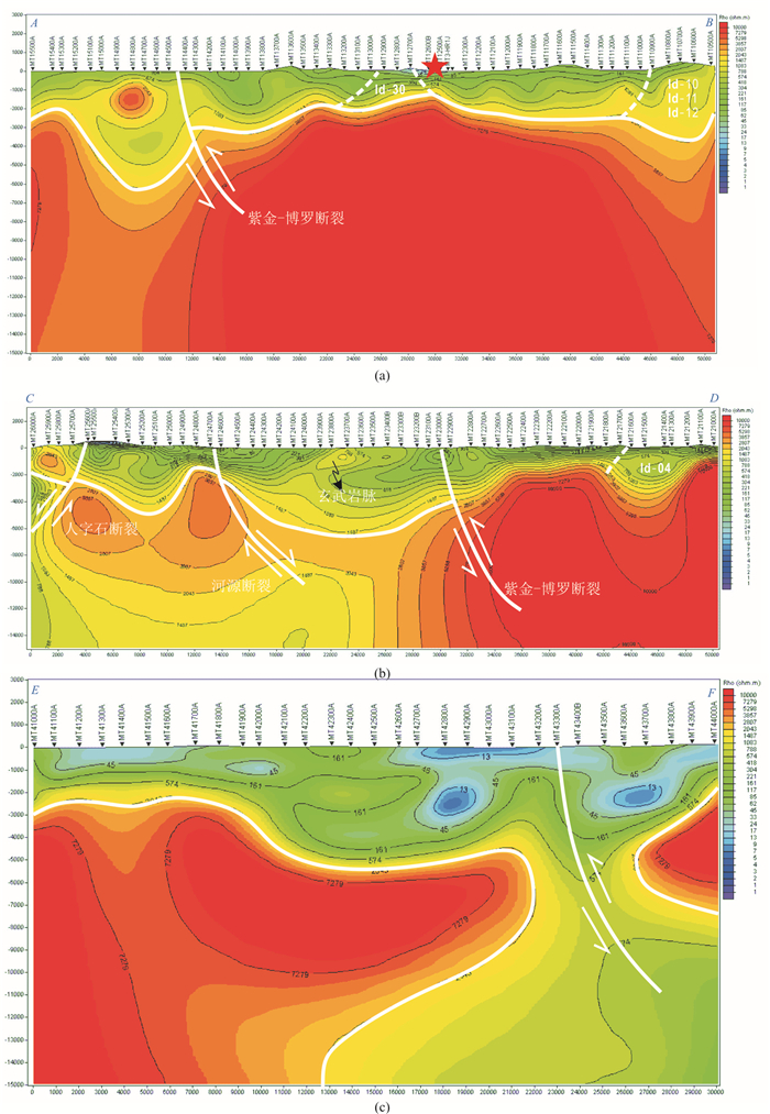
Based on synthesizes basic Geological Survey, magnetotellurics, lithogeochemistry, and chronology, a case study of the Shiba-Huangshadong area in Huizhou was settled to reveal the evolution of geological tectonics since the Yanshanian (Jurassic and Cretaceous era) in Huizhou, Guangdong. The magnetotelluric data display that there are present the subterrane an bedrock of Yanshanian granite intrusions with a thickness of more than 5 km, and the graniteis sliced by the Cenozoic faults. The basal conglomerate minerals in the Danxia Formation have edges and corners, which show near-source sedimentary characteristics.The harmonic age and age spectrum show that the age of basal conglomerate is about 160 Ma.The REE pattern and spider diagram of granites in the study area with age more than 150 Ma indicate that the basal conglomerate is the product of denudation of Yanshanian granite. Based on the tectonic evolution of South China and its adjacent areas, we have established a conceptual model of geological evolution of the study area since the Yanshanian. The emplacement of the voluminous Yanshanian granite resulted in the uplift of the crust.The previously deposited strata suffered from long-term denudation, which caused the expose and denudation of granite that in the Paleozoic and Mesozoic strata. Combined with the Cenozoic large-scale Yue-Gui shearing caused by the collision of India-Eurasia plate and the northward drift of Philippine Plate, forming a series of deep-seated faults, for example, the Heyuan fault, the Zijin-Boluo fault, and the Lianhuashan fault.These faults are all cutting through the Yanshanian granite body. The current topography of the study area has been shaped by multiple activities.
Based on synthesizes basic Geological Survey, magnetotellurics, lithogeochemistry, and chronology, a case study of the Shiba-Huangshadong area in Huizhou was settled to reveal the evolution of geological tectonics since the Yanshanian (Jurassic and Cretaceous era) in Huizhou, Guangdong. The magnetotelluric data display that there are present the subterrane an bedrock of Yanshanian granite intrusions with a thickness of more than 5 km, and the graniteis sliced by the Cenozoic faults. The basal conglomerate minerals in the Danxia Formation have edges and corners, which show near-source sedimentary characteristics.The harmonic age and age spectrum show that the age of basal conglomerate is about 160 Ma.The REE pattern and spider diagram of granites in the study area with age more than 150 Ma indicate that the basal conglomerate is the product of denudation of Yanshanian granite. Based on the tectonic evolution of South China and its adjacent areas, we have established a conceptual model of geological evolution of the study area since the Yanshanian. The emplacement of the voluminous Yanshanian granite resulted in the uplift of the crust.The previously deposited strata suffered from long-term denudation, which caused the expose and denudation of granite that in the Paleozoic and Mesozoic strata. Combined with the Cenozoic large-scale Yue-Gui shearing caused by the collision of India-Eurasia plate and the northward drift of Philippine Plate, forming a series of deep-seated faults, for example, the Heyuan fault, the Zijin-Boluo fault, and the Lianhuashan fault.These faults are all cutting through the Yanshanian granite body. The current topography of the study area has been shaped by multiple activities.


2021, 46(1): 259-271.
doi: 10.3799/dqkx.2019.227
Abstract:
The NNW-SSE striking Huahai fault develops in the Huahai Basin in the western Hexi corridor. Its spatial distribution, kinematics and activity are significance for understanding the tectonic deformation and outgrowth of the northern margin of the Qinghai-Tibet Plateau. Based on the interpretation of satellite images, field surveying, trenching, optical luminescence dating and existing geophysical data, the characteristics of Huahai fault are reported. A landform scarp develops along the Huahai fault, which is approximate 8 km long from Shuangquanzi, Daquan to Xiaoquan. This scarp is caused by the fault related folding. The fault extends southward to the northern Kuantanshan and Heishan ranges indicated by scarps, springs and landforms. The Huahai fault was once a normal fault in the Early Cretaceous, and was inversed to be a thrust fault in the Late Cretaceous. During the Cenozoic, the northward growth of the Qinghai-Tibetan Plateau resulted in development of a series of sinistrally transpressive faults such as the Sanweishan, Ganxiashan, Kuantanshan and Taerwan-Dengdengshan-Chijiaoziwo faults. These faults are boundaries of blocks between the Sanweishan and Altyn Tagh faults, and cause the uplift of the mountain ranges along faults, and the northeastward movement of blocks among faults. The thrusting of the Huahai fault is the response of this recent tectonic event.
The NNW-SSE striking Huahai fault develops in the Huahai Basin in the western Hexi corridor. Its spatial distribution, kinematics and activity are significance for understanding the tectonic deformation and outgrowth of the northern margin of the Qinghai-Tibet Plateau. Based on the interpretation of satellite images, field surveying, trenching, optical luminescence dating and existing geophysical data, the characteristics of Huahai fault are reported. A landform scarp develops along the Huahai fault, which is approximate 8 km long from Shuangquanzi, Daquan to Xiaoquan. This scarp is caused by the fault related folding. The fault extends southward to the northern Kuantanshan and Heishan ranges indicated by scarps, springs and landforms. The Huahai fault was once a normal fault in the Early Cretaceous, and was inversed to be a thrust fault in the Late Cretaceous. During the Cenozoic, the northward growth of the Qinghai-Tibetan Plateau resulted in development of a series of sinistrally transpressive faults such as the Sanweishan, Ganxiashan, Kuantanshan and Taerwan-Dengdengshan-Chijiaoziwo faults. These faults are boundaries of blocks between the Sanweishan and Altyn Tagh faults, and cause the uplift of the mountain ranges along faults, and the northeastward movement of blocks among faults. The thrusting of the Huahai fault is the response of this recent tectonic event.


2021, 46(1): 272-280.
doi: 10.3799/dqkx.2019.278
Abstract:
Reconstruction of the progressive drying and expansion of deserts in eastern Asia during the Quaternary period is important for understanding the evolution of East Asian winter monsoon. The eolian deposits preserved in the Chinese Loess Plateau (CLP) are an unparalleled record of major wet/dry oscillations superimposed on the general drying trend of the Gobi and other nearby deserts of inland Asia. The element concentrations of these loess deposits in the Yangqu section in the eastern Loess Plateau indicate two major stages in the general aridification since 1.2 Ma. The first major step in aridification occurred at 0.94 Ma as indicated by an abrupt decrease of Si, Fe and Rb/Sr proportions and a significant increase of Ca content. We consider that the dominant factor for this drying step in eastern Loess Plateau was the increase of global ice volume, especially of Northern Hemisphere ice sheets, which force the Intertropical Convergence Zone to shift southward and inhibit the northward movement of moisture monsoon airflows. The second stage toward present aridification occurred at about 0.31 Ma. This step may be a localized regional event, perhaps attributed to the breach of Xin-Ding paleolake.
Reconstruction of the progressive drying and expansion of deserts in eastern Asia during the Quaternary period is important for understanding the evolution of East Asian winter monsoon. The eolian deposits preserved in the Chinese Loess Plateau (CLP) are an unparalleled record of major wet/dry oscillations superimposed on the general drying trend of the Gobi and other nearby deserts of inland Asia. The element concentrations of these loess deposits in the Yangqu section in the eastern Loess Plateau indicate two major stages in the general aridification since 1.2 Ma. The first major step in aridification occurred at 0.94 Ma as indicated by an abrupt decrease of Si, Fe and Rb/Sr proportions and a significant increase of Ca content. We consider that the dominant factor for this drying step in eastern Loess Plateau was the increase of global ice volume, especially of Northern Hemisphere ice sheets, which force the Intertropical Convergence Zone to shift southward and inhibit the northward movement of moisture monsoon airflows. The second stage toward present aridification occurred at about 0.31 Ma. This step may be a localized regional event, perhaps attributed to the breach of Xin-Ding paleolake.


2021, 46(1): 281-292.
doi: 10.3799/dqkx.2019.264
Abstract:
In this study, we analyzed pollen samples from two drilling cores located on the coast near Ningde city of Fujian Province for reconstruction paleoenvironment. Optical stimulated luminescence (OSL) and AMS 14C dating revealed that the oldest age in both cores was marine isotope stage (MIS5a). In pollen assemblages, marine dinoflagellate cysts occurred in MIS5a, early MIS3, early and middle Holocene, reflecting the transgression events in these phases. Since MIS5a, pollen assemblages were dominated by evergreen Quercus and Pinus, indicating that surrounding area was consistently covered by subtropical evergreen broadleaved forest and pine forest, which associated with warm subtropical climate. Therefore, this study confirmed that not obvious cooling occurred during the last glacial maximum (MIS2).Strong increase of Dicranopteris spores and non-arboreal pollen reflected that the human activity destroyed natural forest since the late Holocene in Ningde area.
In this study, we analyzed pollen samples from two drilling cores located on the coast near Ningde city of Fujian Province for reconstruction paleoenvironment. Optical stimulated luminescence (OSL) and AMS 14C dating revealed that the oldest age in both cores was marine isotope stage (MIS5a). In pollen assemblages, marine dinoflagellate cysts occurred in MIS5a, early MIS3, early and middle Holocene, reflecting the transgression events in these phases. Since MIS5a, pollen assemblages were dominated by evergreen Quercus and Pinus, indicating that surrounding area was consistently covered by subtropical evergreen broadleaved forest and pine forest, which associated with warm subtropical climate. Therefore, this study confirmed that not obvious cooling occurred during the last glacial maximum (MIS2).Strong increase of Dicranopteris spores and non-arboreal pollen reflected that the human activity destroyed natural forest since the late Holocene in Ningde area.


2021, 46(1): 293-307.
doi: 10.3799/dqkx.2020.056
Abstract:
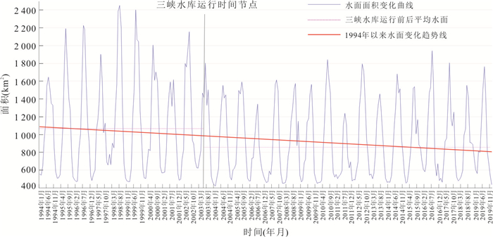
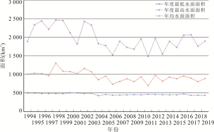
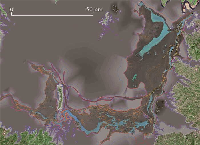
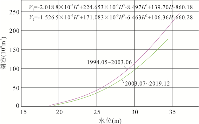
In order to study the changes of water resources amount in Dongting Lake before and after the operation of the Three Gorges Reservoir, this research used 165 multi platform high-resolution (15-30 m) satellite remote sensing data of 1994-2019, combined with the daily observation water level data of Chenglingji for many years and the data of precipitation and evaporation in Dongting Lake area, the water surface information extracted by mask processing and K-means clustering analysis, studies the changes of water surface area and lake capacity of Dongting Lake since 1994. Theoperation of the Three Gorges Reservoir significantly influenced the changes of water resources in Dongting Lake. In this study, 165 multi-platform satellite data were combined with the daily hydrological and meteorological data to explore the changes of water area and lake capacity of Dongting Lake since 1994. The water surface information was extracted by using mask processing and K-means clustering analysis. Results showed that:after the operation of the Three Gorges reservoir, the annual average water surface area decreased from 1 077.46 km2 to 857.13 km2, with a decrease of 20.45% at the water level in Chenglingji was more than 26.34 m after 2011.At the same time, the regulation of the Three Gorges reservoir not only alleviated the hidden danger of the flood disaster of Dongting Lake, but also advanced the dry water level by one month. In addition, the supply water for Dongting Lake was extremely limited during low water level period. After the operation of the Three Gorges Reservoir, the lake capacity of the Dongting Lake was significantly reduced, especially the higher the water level, the greater the reduction; When the water level is less than 20 m, the lake capacity gradually approaches during the before and after operation periods of the Three Gorges Reservoir. The change of water resources of Dongting Lake is mainly affected by the inflow of the lake.The runoff of "four waters" was the main factor determining the water resources of Dongting Lake, but the reduction of runoff of "three outlets" also playedan important role. At the same time, the decrease of annual precipitation and the increase of evaporation were also the reasons for the decrease of water resources in Dongting Lake. The research results provided objective data for the adjustment of lake management ideas, the protection of water resources in Dongting Lake area and the ecological restoration of the Yangtze River basin after the operation of the Three Gorges Reservoir.
In order to study the changes of water resources amount in Dongting Lake before and after the operation of the Three Gorges Reservoir, this research used 165 multi platform high-resolution (15-30 m) satellite remote sensing data of 1994-2019, combined with the daily observation water level data of Chenglingji for many years and the data of precipitation and evaporation in Dongting Lake area, the water surface information extracted by mask processing and K-means clustering analysis, studies the changes of water surface area and lake capacity of Dongting Lake since 1994. Theoperation of the Three Gorges Reservoir significantly influenced the changes of water resources in Dongting Lake. In this study, 165 multi-platform satellite data were combined with the daily hydrological and meteorological data to explore the changes of water area and lake capacity of Dongting Lake since 1994. The water surface information was extracted by using mask processing and K-means clustering analysis. Results showed that:after the operation of the Three Gorges reservoir, the annual average water surface area decreased from 1 077.46 km2 to 857.13 km2, with a decrease of 20.45% at the water level in Chenglingji was more than 26.34 m after 2011.At the same time, the regulation of the Three Gorges reservoir not only alleviated the hidden danger of the flood disaster of Dongting Lake, but also advanced the dry water level by one month. In addition, the supply water for Dongting Lake was extremely limited during low water level period. After the operation of the Three Gorges Reservoir, the lake capacity of the Dongting Lake was significantly reduced, especially the higher the water level, the greater the reduction; When the water level is less than 20 m, the lake capacity gradually approaches during the before and after operation periods of the Three Gorges Reservoir. The change of water resources of Dongting Lake is mainly affected by the inflow of the lake.The runoff of "four waters" was the main factor determining the water resources of Dongting Lake, but the reduction of runoff of "three outlets" also playedan important role. At the same time, the decrease of annual precipitation and the increase of evaporation were also the reasons for the decrease of water resources in Dongting Lake. The research results provided objective data for the adjustment of lake management ideas, the protection of water resources in Dongting Lake area and the ecological restoration of the Yangtze River basin after the operation of the Three Gorges Reservoir.


2021, 46(1): 308-320.
doi: 10.3799/dqkx.2019.261
Abstract:
Natural high iodine groundwater is widely distributed in China. In order to find out the similarities and differences of mechanism of iodine occurrence in groundwater,the Datong basin and the North China Plain (NCP) were selected as representative areas in this study.Groundwater sampling and the analysis of hydrochemistry and iodine species were performed to understand the groundwater environment and hydrochemical evolution.The results showed that total iodine concentration in groundwater from Datong basin was 2.86-1 286 μg/L,and that in NCP was 2.40-1 106 μg/L. Approximately 50.0% and 49.5% of groundwater iodine from Datong basin and North China Plain exceed the national standard of 100 μg/L(GB19380- 2016),respectively. At the Datong basin,the groundwater environment was characterized by organic matter-rich,alkaline,weak reducing and Na-HCO3 type water,which was formed by Quaternary fluvial and lacustrine deposits. Under this environment,the sediment iodine was prone to be released into groundwater in the form of iodide and further enrich in the discharge area along the groundwater flow direction.At the NCP,the six transgressions in the Quaternary leads to the alluvial-lacustrine and marine loose sediments rich in Na,Cl and I. At the coastal area,the alkaline and weak reducing conditions in combination with low hydraulic gradient were favorable for iodine release from aquifer matrix to groundwater.The main species of iodine in groundwater was also iodide.The differences between two areas was that high iodine groundwater at Datong basin was mainly influenced by enriched organic matter in groundwater system,while that at NCP was mainly controlled by iodine-rich marine sediments.
Natural high iodine groundwater is widely distributed in China. In order to find out the similarities and differences of mechanism of iodine occurrence in groundwater,the Datong basin and the North China Plain (NCP) were selected as representative areas in this study.Groundwater sampling and the analysis of hydrochemistry and iodine species were performed to understand the groundwater environment and hydrochemical evolution.The results showed that total iodine concentration in groundwater from Datong basin was 2.86-1 286 μg/L,and that in NCP was 2.40-1 106 μg/L. Approximately 50.0% and 49.5% of groundwater iodine from Datong basin and North China Plain exceed the national standard of 100 μg/L(GB19380- 2016),respectively. At the Datong basin,the groundwater environment was characterized by organic matter-rich,alkaline,weak reducing and Na-HCO3 type water,which was formed by Quaternary fluvial and lacustrine deposits. Under this environment,the sediment iodine was prone to be released into groundwater in the form of iodide and further enrich in the discharge area along the groundwater flow direction.At the NCP,the six transgressions in the Quaternary leads to the alluvial-lacustrine and marine loose sediments rich in Na,Cl and I. At the coastal area,the alkaline and weak reducing conditions in combination with low hydraulic gradient were favorable for iodine release from aquifer matrix to groundwater.The main species of iodine in groundwater was also iodide.The differences between two areas was that high iodine groundwater at Datong basin was mainly influenced by enriched organic matter in groundwater system,while that at NCP was mainly controlled by iodine-rich marine sediments.


2021, 46(1): 321-330.
doi: 10.3799/dqkx.2020.032
Abstract:
Landslide spatial susceptibility assessment can assist to conduct the prevention and mitigation of landslides,in which the application of effective landslide models plays a significant role. Taking Hubei section of the Three Gorges Reservoir Area as study area,nine influencing factors including elevation,slope angle,slope structure,land use,engineering rock group,distance to faults,distance to roads,distance to rivers,and normalized difference vegetation index were selected to to establish the landslide spatial database.Then the random forest ensemble algorithm was used to assess landslide susceptibility. The results show that the sampling training scheme of random forest benefits to search suitable training parameters,and enables the random forest achieve desirable fitting ability and generalization skill when avoiding the over-fitting problem. The landslide susceptibility mapping results developed by random forest show a reasonable spatial distribution,where 73.35% of the landslides are located in highly and very highly susceptible areas. Furthermore,the areas of northern Badong county,central Zigui county and the southern Yiling district show a higher susceptibility level. The performance evaluation and statistical results of susceptibility show that the random forest is an excellent algorithm,and has a good applicability in the field of landslide spatial prediction.
Landslide spatial susceptibility assessment can assist to conduct the prevention and mitigation of landslides,in which the application of effective landslide models plays a significant role. Taking Hubei section of the Three Gorges Reservoir Area as study area,nine influencing factors including elevation,slope angle,slope structure,land use,engineering rock group,distance to faults,distance to roads,distance to rivers,and normalized difference vegetation index were selected to to establish the landslide spatial database.Then the random forest ensemble algorithm was used to assess landslide susceptibility. The results show that the sampling training scheme of random forest benefits to search suitable training parameters,and enables the random forest achieve desirable fitting ability and generalization skill when avoiding the over-fitting problem. The landslide susceptibility mapping results developed by random forest show a reasonable spatial distribution,where 73.35% of the landslides are located in highly and very highly susceptible areas. Furthermore,the areas of northern Badong county,central Zigui county and the southern Yiling district show a higher susceptibility level. The performance evaluation and statistical results of susceptibility show that the random forest is an excellent algorithm,and has a good applicability in the field of landslide spatial prediction.


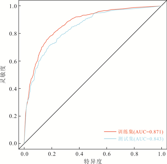

2021, 46(1): 331-340.
doi: 10.3799/dqkx.2019.246
Abstract:
To better understand vegetation change in the northeastern Sunda shelf since the last glacial period and its significance for carbon cycle,we analyzed long-chain n-alkanes in a sediment core (18252-3) on the southwest slope of the South China Sea covering the last 40 000 years. Our data show that carbon preference index (CPI27-33) was correlated well with sea level changes since the last glacial period. During the glacial time,greater odd-to-even predominance and higher concentration of long-chain n-alkanes (C27-C33) than thereafter reflect higher freshness of these leaf wax n-alkanes,indicating a main vegetation source from the nearby exposed shelf. This could be also the cause for the higher contents of total leaf wax n-alkanes (∑oddC27-C33) during the glacial low sea-level time. The average chain length (ACL27-33) increased since 40 ka B.P.,reflecting more herbaceous contribution and/or slight drying of climate. Our data also show that the relative content of n-C29 and n-C31 alkanes was not significantly different and much higher than that of n-C33 on the exposed Sunda shelf during the glacial period. However,the relative content decreased for n-C29 significantly,but increased for n-C33 in Holocene. Along with previous studies in the southeastern Sunda shelf,the data indicate that the exposed shelf was dominated by tropical rainforest during the glacial period. Because the tropical rainforests may reserve substantial organic carbon,the Sunda shelf was likely to be a huge carbon sink during the glacial period.
To better understand vegetation change in the northeastern Sunda shelf since the last glacial period and its significance for carbon cycle,we analyzed long-chain n-alkanes in a sediment core (18252-3) on the southwest slope of the South China Sea covering the last 40 000 years. Our data show that carbon preference index (CPI27-33) was correlated well with sea level changes since the last glacial period. During the glacial time,greater odd-to-even predominance and higher concentration of long-chain n-alkanes (C27-C33) than thereafter reflect higher freshness of these leaf wax n-alkanes,indicating a main vegetation source from the nearby exposed shelf. This could be also the cause for the higher contents of total leaf wax n-alkanes (∑oddC27-C33) during the glacial low sea-level time. The average chain length (ACL27-33) increased since 40 ka B.P.,reflecting more herbaceous contribution and/or slight drying of climate. Our data also show that the relative content of n-C29 and n-C31 alkanes was not significantly different and much higher than that of n-C33 on the exposed Sunda shelf during the glacial period. However,the relative content decreased for n-C29 significantly,but increased for n-C33 in Holocene. Along with previous studies in the southeastern Sunda shelf,the data indicate that the exposed shelf was dominated by tropical rainforest during the glacial period. Because the tropical rainforests may reserve substantial organic carbon,the Sunda shelf was likely to be a huge carbon sink during the glacial period.


2021, 46(1): 341-349.
doi: 10.3799/dqkx.2020.250
Abstract:
The sea surface flow field can directly affect the climate change of the sea surface,and is of great significance to the study of air-sea interaction and heat flux transfer. This paper uses altimeter data from Jason-2 and HY-2 satellite,scatterometer data from ASCAT of Metop and HY-2 satellite to estimate the sea surface flow field. The grid with resolution of 0.25°×0.25° is generated by the method of weighted average distance,the sea surface elevation field and wind field are obtained by data fusing. On this basis,the inversion mathematical models of the geostrophic flow and the Ekman flow are constructed. The geostrophic flow is retrieved from Jason-2 and Hy-2 altimeter data,and the wind-driven Ekman flow is obtained from the ASCAT and Hy-2 scatterometer data,the combination of both date results in the sea surface flow field. By comparing the inversion results of the sea surface flow in the study area with OSCAR current products,it is found that the closer to the equator,the greater the error of the velocity of the sea surface flow. The maximum relative error reached 0.6 m/s. The experimental results show that the sea surface flow field estimated by satellite remote sensing data can exactly describe the basic characters of actual sea surface flow field.
The sea surface flow field can directly affect the climate change of the sea surface,and is of great significance to the study of air-sea interaction and heat flux transfer. This paper uses altimeter data from Jason-2 and HY-2 satellite,scatterometer data from ASCAT of Metop and HY-2 satellite to estimate the sea surface flow field. The grid with resolution of 0.25°×0.25° is generated by the method of weighted average distance,the sea surface elevation field and wind field are obtained by data fusing. On this basis,the inversion mathematical models of the geostrophic flow and the Ekman flow are constructed. The geostrophic flow is retrieved from Jason-2 and Hy-2 altimeter data,and the wind-driven Ekman flow is obtained from the ASCAT and Hy-2 scatterometer data,the combination of both date results in the sea surface flow field. By comparing the inversion results of the sea surface flow in the study area with OSCAR current products,it is found that the closer to the equator,the greater the error of the velocity of the sea surface flow. The maximum relative error reached 0.6 m/s. The experimental results show that the sea surface flow field estimated by satellite remote sensing data can exactly describe the basic characters of actual sea surface flow field.


2021, 46(1): 350-358.
doi: 10.3799/dqkx.2020.111
Abstract:
Mining and integrating geological prospecting information using deep learning algorithms (DL) has become a frontier field of mathematical geoscience. DL,which is a machine learning algorithm with multiple hidden layers,starts to be used in mining the geological prospecting big data in recent years,and there are a series of issues to be solved in this field. In this study,we took the convolutional neural network (CNN) as an example to discuss two challenges of DL on mining geological prospecting big data,which include insufficient training samples and how to construct deep learning network structure. In this study,the data augmentation methods were applied to generate training dataset,duplicating and adding noise,and a number of number of experiments were carried out for determining the optimal hyper-parameters of a CNN model for mining and integrating geological prospecting big data. A case study from Southwest Fujian Province,China,was carried out to mine and integrate the geological,geophysical and geochemical multi-source prospecting information. The results obtained by CNN can provide clues for mineral exploration in this area.
Mining and integrating geological prospecting information using deep learning algorithms (DL) has become a frontier field of mathematical geoscience. DL,which is a machine learning algorithm with multiple hidden layers,starts to be used in mining the geological prospecting big data in recent years,and there are a series of issues to be solved in this field. In this study,we took the convolutional neural network (CNN) as an example to discuss two challenges of DL on mining geological prospecting big data,which include insufficient training samples and how to construct deep learning network structure. In this study,the data augmentation methods were applied to generate training dataset,duplicating and adding noise,and a number of number of experiments were carried out for determining the optimal hyper-parameters of a CNN model for mining and integrating geological prospecting big data. A case study from Southwest Fujian Province,China,was carried out to mine and integrate the geological,geophysical and geochemical multi-source prospecting information. The results obtained by CNN can provide clues for mineral exploration in this area.

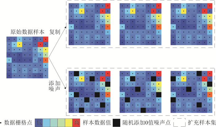

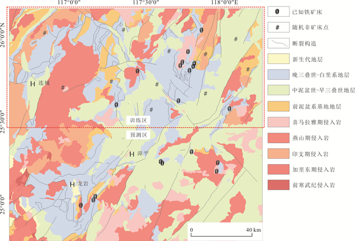
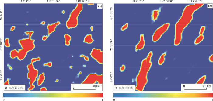

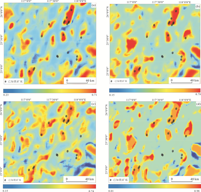


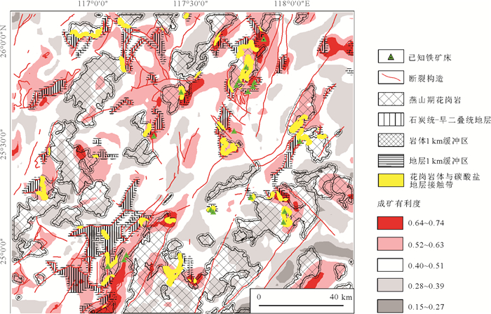
2021, 46(1): 359-368.
doi: 10.3799/dqkx.2020.038
Abstract:
In the western Pacific,the Huatung basin (HB) might be a unique Early-Cretaceous oceanic basin located at the junction between the Philippine Sea plate (PSP) and Eurasia plate (EU). The HB is the key region to understand the geodynamic evolution of the western Pacific as a whole. It is a natural laboratory to investigate the interaction between the Earth's hydrosphere and lithosphere of a subduction system. Some essential scientific questions are essential toneed to be addressed based on the previous research.What is the nature and age of the crust in the HB? What is its history of formation and evolution? What is the uplift mechanism andtectonic nature of the NS-oriented Gagua ridge? For the Manila subduction zone,acting as the western boundary of the HB,what is the water content in the sediments and in the upper and lower crust of the subducting slab determined by the detailed seismic velocity structure? What is the mechanism of water emplacement? An active- and passive-source seismic experiment is necessary to be carried out also including sample dredges in near future. The crustal and mantle velocity structure beneath the HB could be acquired by the use of joint inversion of P- and S-waves. These research will not only provide geophysical constraints to understand the interaction of the Earth's hydrosphere and lithosphere of a subduction system,but will also contribute to the understanding of the tectonic framework of the western Pacific. More importantly,it is a pre-requisite before getting drilling ground truth in the HB.
In the western Pacific,the Huatung basin (HB) might be a unique Early-Cretaceous oceanic basin located at the junction between the Philippine Sea plate (PSP) and Eurasia plate (EU). The HB is the key region to understand the geodynamic evolution of the western Pacific as a whole. It is a natural laboratory to investigate the interaction between the Earth's hydrosphere and lithosphere of a subduction system. Some essential scientific questions are essential toneed to be addressed based on the previous research.What is the nature and age of the crust in the HB? What is its history of formation and evolution? What is the uplift mechanism andtectonic nature of the NS-oriented Gagua ridge? For the Manila subduction zone,acting as the western boundary of the HB,what is the water content in the sediments and in the upper and lower crust of the subducting slab determined by the detailed seismic velocity structure? What is the mechanism of water emplacement? An active- and passive-source seismic experiment is necessary to be carried out also including sample dredges in near future. The crustal and mantle velocity structure beneath the HB could be acquired by the use of joint inversion of P- and S-waves. These research will not only provide geophysical constraints to understand the interaction of the Earth's hydrosphere and lithosphere of a subduction system,but will also contribute to the understanding of the tectonic framework of the western Pacific. More importantly,it is a pre-requisite before getting drilling ground truth in the HB.

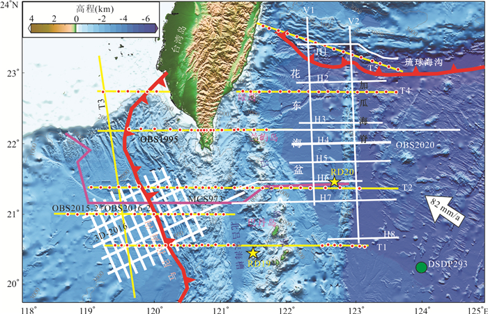


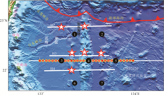
2021, 46(1): 369-380.
doi: 10.3799/dqkx.2019.265
Abstract:
Rotational seismology is a new subject to study the motions of the earth's medium caused by earthquakes, blasting and environmental vibration in an all-round way. The study of rotational components of ground motion has a long history. However, there is no high-precision rotational component seismograph, so the study of rotational motions is usually limited to theoretical aspects. As an alternative method of calculating rotational components by translational components, the finite difference method is relatively mature in theoretical research, but its application in practical data is still less. Based on the full investigation of the research that studying the rotational motions, the finite difference method is tested and analyzed by using the simulated data and the recording explosive source data. By comparing the waveforms, amplitude spectra and phase spectra of the rotational components calculated by the finite difference method with thoserecorded, it is concluded that the finite difference method can be used as an effective alternative to calculate the horizontal rotational components (RX, RY) within an error allowable range. At the same time, in view of the high frequency characteristics of the explosive source and the dense array, we have improved the finite difference method and proposed a higher precision finite difference method for calculating rotational components.
Rotational seismology is a new subject to study the motions of the earth's medium caused by earthquakes, blasting and environmental vibration in an all-round way. The study of rotational components of ground motion has a long history. However, there is no high-precision rotational component seismograph, so the study of rotational motions is usually limited to theoretical aspects. As an alternative method of calculating rotational components by translational components, the finite difference method is relatively mature in theoretical research, but its application in practical data is still less. Based on the full investigation of the research that studying the rotational motions, the finite difference method is tested and analyzed by using the simulated data and the recording explosive source data. By comparing the waveforms, amplitude spectra and phase spectra of the rotational components calculated by the finite difference method with thoserecorded, it is concluded that the finite difference method can be used as an effective alternative to calculate the horizontal rotational components (RX, RY) within an error allowable range. At the same time, in view of the high frequency characteristics of the explosive source and the dense array, we have improved the finite difference method and proposed a higher precision finite difference method for calculating rotational components.