2021 Vol. 46, No. 10
 PDF 972KB
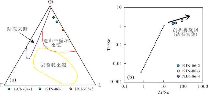
The formation and denudation of the Early Paleozoic Jiangnan uplift can be used to restrict the Kwangsian orogeny and its dynamic mechanism in South China. Based on detrital zircon U-Pb geochronology and trace element geochemistry of the quartzose conglomerate of the Middle Devonian Tiaomajian Formation in Nanwan, south of the Jiangnan Uplift, the provenance and tectonic significance of the conglomerate are discussed. U-Pb ages of 270 available detrital zircons from the four samples consist of main peaks of 430-440 Ma and sub-peaks of 800-1 100 Ma, 1 700-2 000 Ma and 2 400-2 600 Ma. Zircon CL images, Th/U ratios and REE partition patterns indicate that detrital zircons are dominated by magmatic zircons, with only a small amount of metamorphic and hydrothermal zircons. The mineral morphology, composition and maturity indicate that the source area is near source and deposited in coastal environment. The comprehensive source analysis shows that the provenance of the quartzite conglomerate of the Middle Devonian Tiaomajian Formation in southeastern Hunan is from the Jiangnan Uplift on the north side. The Jiangnan uplift was formed during the Kwangsian period of intracontinental orogeny. The trace element geochemical characteristics of the Early Paleozoic magmatic zircons indicate that they are of continental type and formed in a continental arc tectonic setting. Combined with the regional geological characteristics, the Kwangsian orogeny in South China is the product of oceanic subduction on its southern side, which is related to the aggregation of Gondwana continent.


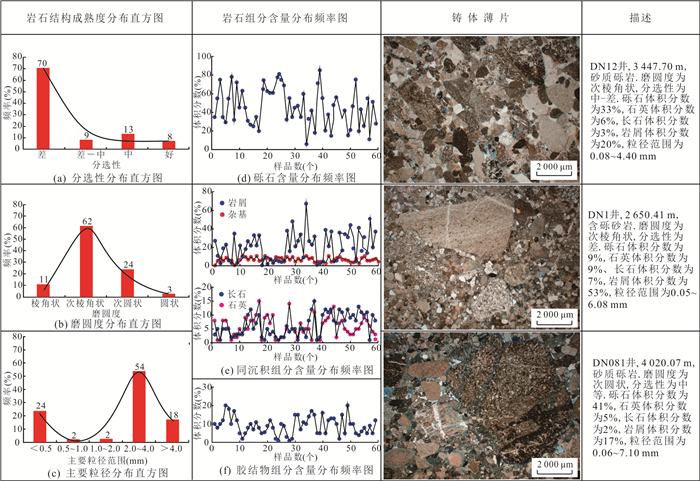
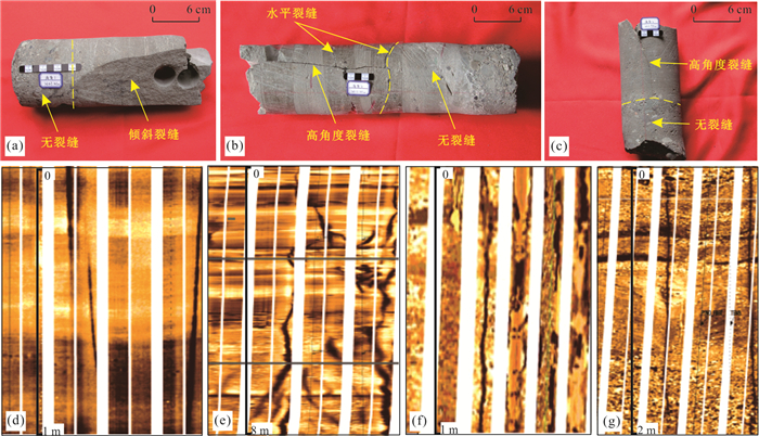
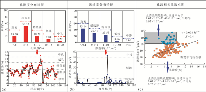
The quantitative evaluation criterion for the conglomerate reservoir was established on the basis of studying the micro heterogeneity characteristics of reservoir, in order to understand micro heterogeneity and quantitatively evaluate the degree of densification for the conglomerate reservoir of the Upper Permain Wutonggou Formation int DN8 area of the Dongdaohaizi sag, eastern Junggar basin, based on identification of blue epoxy resin-impregnated thin sections, analysis of scanning electron microscope (SEM), X-ray diffraction (XRD) of minerals, high-pressure capillary pressure, combined with previous research results. The results show that the micro heterogeneity of reservoir mainly includes petrological heterogeneity, pore throat heterogeneity and fracture heterogeneity. In petrological heterogeneity, the rock structural heterogeneity caused by the difference of rock structural maturity restricts the initial physical property of reservoir. The degree of reservoir densification is affected by types and contents of gravels, cuttings in synsedimentary interstitial matterial and cements after compaction and cementation. The degree of current reservoir densification is affected by the pore throat heterogeneity and fracture heterogeneity, which caused by the difference of diagenesis-pore evolution process after dissolution and the fracture development density. The diagenetic comprehensive parameter (DCP) and formation brittleness index (FBI) are thus put forward to characterize densification degree of the reservoir, which can be divided into three grades. The DCP is greater than 4.0 and the FBI is greater than 0.8 in the first grade of densification. The DCP is between 3.0-4.0 and the FBI is between 0.3-0.8 in the second grade of densification, and the DCP is less than 3.0 and the FBI is less than 0.3 in the third grade of densification. The tight reservoir of the first grade is with the best pore throat structure and the highest quality, thus of the weakest micro heterogeneity, which is the favorable conglomerate reservoir in the study area.


Quantitative characterization of architecture of the interlayer oxidation zone is very important to reveal the regularity of uranium mineralization. In this study, the interlayer oxidation zone of the Qianjiadian uranium deposits in the Songliao basin was quantitatively characterized by sedimentological and geochemistry mappings. It is found that the interlayer oxidation zone of the deposit is mainly composed of red sandstone, light yellow sandstone, gray white sandstone, gray mineralized sandstone and primary gray sandstone, respectively corresponding to strong oxidised subzone, weak oxidised subzone, faint oxidised subzone, transitional zone and reduction zone. The uranium mineralization is closely related to the internal architecture of interlayer oxidation zone. The main industrial uranium ore bodies are strictly developed in the transitional zone. A few ore bodies whose continuity is poor occur in the faint oxidised subzone. The ore bodies are sporadically distributed in the weak oxidation subzone. The low-grade uranium ore bodies are found in the side of reduction zone close to transitional zone. Formation of the interlayer oxidation zone is restricted by the heterogeneity of uranium reservoir sandstones and depositional systems. The oxidised zone is mainly developed in sand bodies of the braided river and braided distributary channel, and the transition zone primarily distributed at the edge of the braided distributary channel or in the crevasse fan.


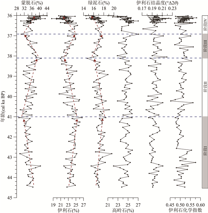
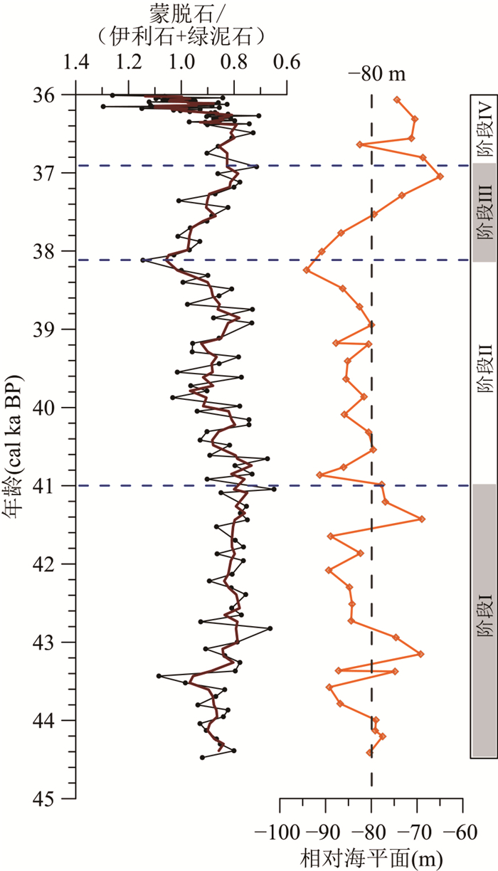
Variation in source of terrigenous sediments on the Sunda Shelf in the southern South China Sea during the sea-level lowstand is of great significance to reconstruct the evolution of the land-sea configuration. Varying provenances response to sea-level fluctuations within Marine Isotope Stage 3 (MIS 3) was investigated by high-resolution clay mineralogy of Core 18282-2 recovered from the outer Sunda Shelf. The results indicate that clay mineral compositions on the outer shelf show relatively high contents of smectite (29%-44%), moderate contents of kaolinite (21%-27%), illite (19%-27%), and chlorite (14%-20%). The provenance analysis based on clay mineralogy suggests a mixture of individual clay mineral from various sources surrounding the southern South China Sea. Smectite originated mainly from Sumatra and middle Thailand. Kaolinite derived mainly from the Malay Peninsula, Sumatra, and western Borneo. Illite and chlorite were mainly contributed by the Mekong River. During 44.5-36.0 cal ka BP, the sea-level was below -80 m for most of the time, the vast paleo-river systems developed on the emerged shelf, namely the North Sunda River, the paleo-Chao Phraya River, and the paleo-Mekong River. Terrigenous sediments from the surrounding provenances were transported through these major ancient drainage systems directly to the outer shelf at that time. Variations in the smectite/(illite + chlorite) ratios correspond well to the sea-level fluctuations with relatively higher ratios developed during the sea-level lowering periods, implying that the sedimentary environmental evolution during the MIS 3 on the outer Sunda Shelf was dominantly controlled by the sea-level change. Modification of the land-sea configuration resulted from sea-level fluctuations, especially the migration of paleo-coastlines, could significantly affect the transport distance between the paleo-river mouths and the study area, resulting in variations in relative contributions of the surrounding provenances to the outer Sunda Shelf.


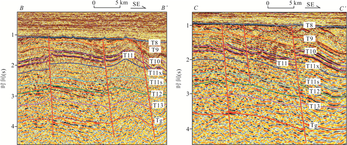
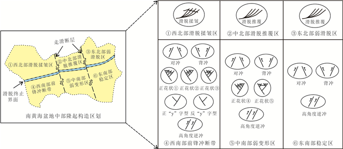
By selecting typical seismic sections with clear internal seismic reflection and obvious structural features to carry out delicate structural interpretation, in this paper it systematically combines the structural style features of the central uplift in the South Yellow Sea basin, and identified the compressional structures (detachment, high angle thrust, opposite/back thrust), strike slip faults (positive flower, y-shaped), extensional normal fault (shovel-like normal fault) in the central uplift of the South Yellow Sea basin and so on. Among them, two NW-SE strike slip faults are proposed for the first time. On this basis, combined with the characteristics of regional stress field and the background of deep geodynamics, the development period, genetic mechanism and structural evolution course of the structural style in the central uplift are defined. The results show follows. (1) The detachment structure was mainly located in the north of the central uplift, and the detachment surface was located in the shale at the bottom of the Silurian strata. The tectonic stress mechanism of detachment originated from the collision orogeny between the North China plate and the Lower Yangtze plate at the end of Triassic. (2) The high angle thrust was mainly located in the south of the central uplift. The stress mechanism of the high angle thrust came from the initial high-speed and low angle NW subduction of the ancient Pacific plate during the early Yanshanian movement in Early Jurassic. (3) The strike slip faults were mainly positive flower structures with compression and torsion characteristics, which were located in the southeast and mid-west of the central uplift. The stress mechanism came from the sinistral shear caused by the low angle subduction of the ancient Pacific plate from NW to NNW in Early Cretaceous. The Tan-Lu fault in eastern China also showed sinistral shear characteristics in this period. (4) The extensional normal fault was characterized by shovel-like normal fault, which was developed in the north-south boundary of the central uplift, that was, the contact parts between the central uplift and the southern depression, the northern depression of the South Yellow Sea basin. The stress mechanism was derived from the transition of the paleo Pacific plate from low angle subduction to high angle subduction during the late Yanshanian movement in Late Cretaceous. At this time, the tectonic stress system in eastern China also changed from compression to extension.


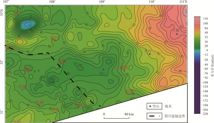
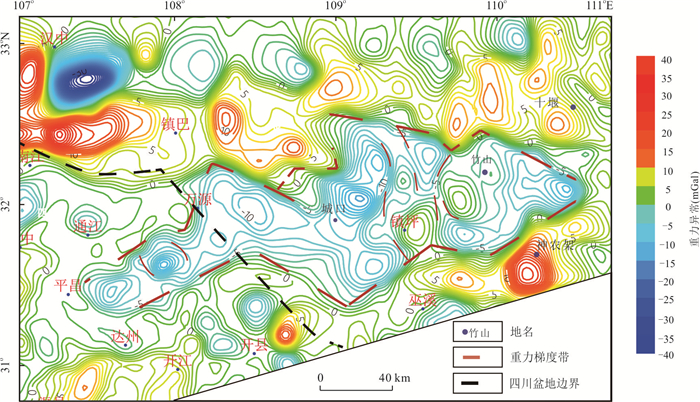
A series of rift valleys and their related sedimentary basins were developed in South China during Nanhua period. There are direct evidences of rift valleys in Kangdian area, Sichuan basin and Hunan-Guangxi area. However, there is no clear understanding of the existence of rift basin due to the complex terrain and weak previous studies in the Daba Mountain area. The study of this area is helpful to understand the existence of Nanhua rift in Daba Mountain area and provides some enlightenment for the study of tectonic evolution in northern Yangtze block.In this paper, the gravity anomaly and field outcrop data were used to carry out a comprehensive study in this area. The present distribution pattern of Nanhua rift was revealed in Daba Mountain area, northern Yangtze block, and the stratigraphic filling sequence and spatial framework in and between the rifts were constructed. The study shows that the Daba Mountain rift is east-west trending along Zhushan-Dazhou, extending from the middle of South Qinling to the northeast of Sichuan basin. Based on the basin framework and sedimentary filling characteristics, the tectonic background of the back-arc rift in the Daba Mountain area is proposed, which provides enlightenment for the Neoproterozoic dynamic mechanism in the northern margin of the Yangtze block.


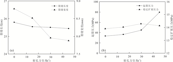
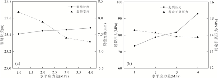
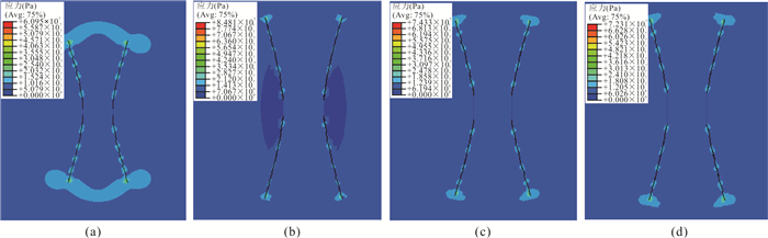
Hydraulic fracturing is one of the main geothermal energy exploitation methods, and its fracturing effect is not only related to the basic physical and mechanical properties of the rock mass, but also closely related to the distribution of fractures, the state of in-situ stress, and the engineering parameters of fracturing. To explore the influence of the above factors of the fracture propagation behavior in the process of hydraulic fracturing, in this paper it takes the carbonatite reservoir rock mass in Jizhong depression as the research object. Based on the extended finite element method, a fracture propagation fluid-solid coupling model is established and analyzed. The influence of parameters such as horizontal stress difference, perforation azimuth angle, injection fluid displacement, and fracturing fluid viscosity on fracture propagation behavior. The results show: When a single fracture propagates, the smaller the perforation azimuth angle and the larger the injection rate, the more conducive to fracture propagation. When double cracks propagate, the horizontal stress difference increases, and the degree of crack deflection decreases. When hydraulic fractures intersect with natural fractures, the smaller horizontal stress difference is beneficial to the opening of natural fractures.


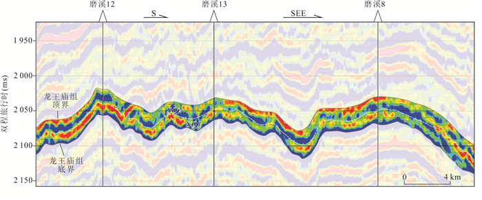
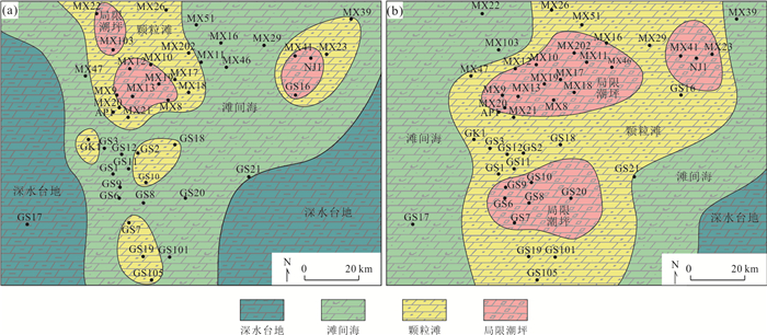
Based on seismic data, well-logging and cores, an integrated research on the microfacies and sequence stratigraphy and reservoir characteristics is made, in order to clarify the controls of the high-frequency sequence and microfacies on the reservoirs in the Longwangmiao Formaion, Central Sichuan basin. The Longwangmiao Formation is mainly composed of eight types of lithofacies such as ooid grainstone, intraclast grainstone and spotted-structure silt crystalline dolomite. They can be grouped into three types of facies associations which are deep-platform to inter-shoal, grain shoal, and restricted tidal flat. The Longwangmiao Formation consists of one third-order sequence and two fourth-order sequences, and either fourth-order sequence includes three to five fifth-order sequences. In the high-frequency sequence stratigraphic framework, tidal flat and grain shoal deposits show clear aggregation and southeastern progradation trends, and they are better developed in SQ2 than in SQ1. The fine to silt crystalline dolomite and spotted-structure silt crystalline dolomite that developed in restrict tidal flat are best in porosity, and they are mainly distributed in the upmost part of the fourth- and fifth-order sequences. The shoal deposits are the second best in reservoir quality and they mainly developed in the middle and upper parts of the sequences below the tidal flat. The early-stage dissolution related to high-frequency sea-level fluctuations is the basis for the formation of the best reservoir of the Longwangmiao Formation in the Central Sichuan basin, and laid the foundation for the later improvement.


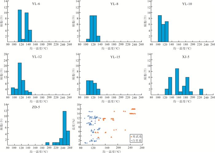
The homogenization temperatures of aqueous inclusions coeval with the hydrocarbon inclusions are widely distributed in carbonate minerals, which leads to that the timing of oil charge interpreted by fluid inclusion homogenization temperatures combined with burial and thermal histories of reservoir is ambiguity. Taking the carbonate of Ordovician in Tahe oilfield of the Tarim basin as an example, the timing of oil charge determined by the minimum homogenization temperature of aqueous inclusions coeval with the hydrocarbon inclusions combined with burial and thermal histories is suggested and the timing of oil charge in the Ordovician strata of Tahe oilfield was investigated in this study based on the investigation of the lithography, microspectrofluorimetry and microthermistry of fluid inclusions developed in calcite veins combined with the result of in-situ U-Pb dating by laser ablation. There are four episodes of oil charge in Tahe oilfield. The timing of the first to third episodes of oil charge is consistent with the formation time of three calcite veins and the fourth episode of oil charge occurred after the three calcite veins. The results of the U-Pb dating by laser ablation of the calcite veins associated with primary oil inclusions indicate that the absolute age of calcite veins is consistent with the timing of oil charge determined by the minimum homogenization temperature of aqueous inclusions coeval with the oil inclusions combined with burial and thermal histories, which confirmed that the timing of oil charge determined by the minimum homogenization temperature of aqueous inclusions coeval with the hydrocarbon inclusions combined with burial and thermal histories is more credible. Finally, it is suggested that the timing of the four episodes of oil charge in Ordovician of Tahe oilfield occurred at the periods of the Caledonian, the Hercynian, the Indosinian, and the Yanshanian tectonic movements respectively.


Based on the drilling data and seismic data of Lishui sag, the distribution and major controlling factors of CO2 reservoirs are studied by combining geochemical parameters of natural gas and development characteristics of basement faults and magma diapirs. The results show that CO2 is mainly concentrated in Lingfeng Formation, lower segment of Mingyuefeng Formation and Proterozoic basal gneiss in the vertical. Besides, the content of CO2 varies greatly in different layers. Laterally, Wenzhou 13-1, Lishui 35-7 and Nanping 5-2 structural CO2 gas reservoirs are located on or near the magma diapirs, and there are faults around these CO2 gas reservoirs. Whereas, there is no diapir near Lishui 36-1 structural CO2 gas reservoirs and LF-1 containing CO2 gas reservoir, but they are adjacent to large depression-controlling faults which are located at west side of Lingfeng uplift. The distribution of CO2 gas reservoirs in the Lishui sag is mainly controlled by two stages magmatic activities, which are respectively in Early Miocene and Late Miocene. Mantle-derived CO2 gas is carried by the deep volcanic magma activities to shallow crust, then migrates along with sand body to favorable traps and forms CO2 gas pools.


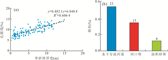
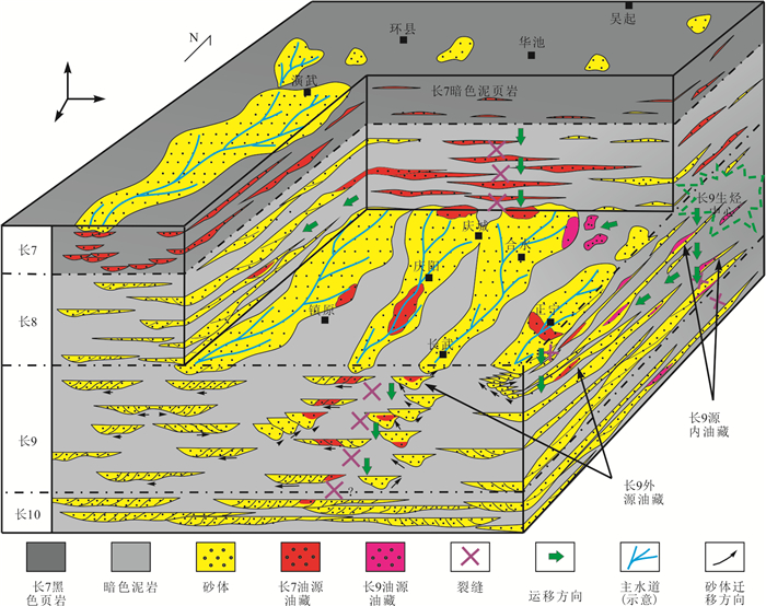
The exploration practice shows that the Yanchang Formation in Ordos basin is rich in oil and gas resources, but there are obvious differences in oil and gas accumulation in different or the same member. Based on a large number of core and drilling/logging data, in this paper it systematically analyzes the lithology and rock association, sedimentary facies and oil accumulation characteristics of the Triassic Yanchang Formation in Longdong area, Ordos basin. The results show that Chang 9 Member in Longdong area was formed under the background of rapid expansion of Ordos basin and gradual deepening of water. River controlled delta deposits and lake (gravity flow) deposits mainly developed in southwest direction. Among them, underwater distributary channel, mouth bar and basin floor fan of delta front are the main reservoir sandstone genetic types of Chang 9 member. Influenced by the changes of water depth and hydrodynamic intensity, the distributary rivers in the delta front are cut and overlapped with each other, and the sandbodies along the dispersion direction of main provenance have the characteristics of "strip", "belt", "blanket" and then "sheet". There are two types of oil reservoirs, i.e. "self generation and self storage" type and "upper generation and lower reservoir" type. It is common to form "upper generation and lower reservoir" type oil reservoirs of type Ⅰ crude oil with Chang 7 black shale as oil source. The reservoirs are mainly composed of underwater distributary channel and channel-bar sandstone, mostly lithologic and structural lithologic reservoirs, which are continuously distributed along the delta formed by each main source direction. However, the formation of "self generation and self storage" type oil reservoirs, mainly composed of type Ⅱ crude oil, is closely related to the basin floor fan sandbodies produced by the interbedding of Chang 9 source rocks, and are distributed in the semi deep lake area near the Chang 9 member along the Zhidan-Huachi-Huaishuzhuang. In addition, the oil in the reservoir is mainly concentrated in the parts with relatively good properties such as underwater distributary channel and mouth bar. This study considers that the spatial configuration of "source reservoir", physical properties of reservoir and spatial connectivity of sand body are the main controlling factors of oil differential migration and accumulation in Chang 9 member.


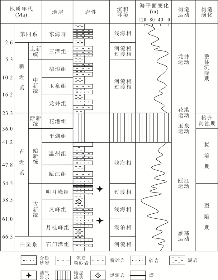
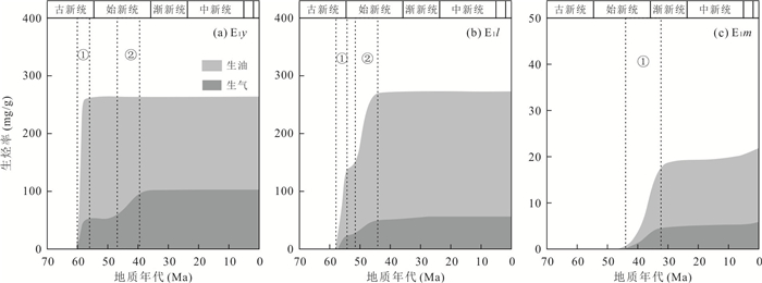
In order to understand oil and gas exploration potential of Jiaojiang sag in the East China Sea basin, hydrocarbon generation capacity and process of the Paleocene Yueguifeng (E1y), Lingfeng (E1l) and Mingyuefeng (E1m) Formations were investigated using geochemical analysis and basin modeling. Results show that E1y and E1l mudstones are high-quality source rocks with high organic matter abundance and type Ⅱ kerogen, which is dominated by both aquatic organisms and terrestrial higher plants deposited in sub-reduced environment. E1m mudstone interbedded with thin carbonaceous mudstone and coal is poor-quality source rock with low organic matter abundance and type Ⅲ kerogen, whose organic matter was derived from terrestrial higher plants under oxidized environment. Great subsidence and high paleo-heat flow from the Paleocene to the Eocene made it main period for increasing thermal maturity of source rocks. Controlled by burial and maturity histories, the E1y and E1l formations experienced two hydrocarbon generation stages, which took place in the Late Palaeocene and in the Middle to Late Eocene, respectively, and is characterized by high hydrocarbon generation potential. The E1m Formation only had one hydrocarbon generation process at the end of Eocene, which is characterized by low hydrocarbon generation potential. The Paleocene source rocks in the Jiaojiang sag have strong hydrocarbon generation capacity, so the future oil and gas exploration should focus on hydrocarbon generation center, especially that of the E1y Formation, and select effective traps formed before the Miocene.


Overpressure in sedimentary basins is widely concerned, but the lack of understanding of mechanism of the overpressure transfer restricts the exploration of oil and gas in the over-pressured reservoir of sedimentary basins. Taking Jurassic overpressure of Fukang sag in Junggar basin as an example, the important contribution of vertical transfer overpressure to reservoirs was recognized for the first time through the comprehensive geological studies of overpressure type, the theoretical calculation of characterization parameters of overpressure and the fluid inclusion pressure recovery. Combined with the overpressure vertical transfer mechanism and process, the application for oil migration and accumulation and leakage in the over-pressured reservoir is discussed. The research results indicate that the Jurassic overpressure in Fukang sag is caused by seven kinds of pressure factors in four different overpressure environments. Furthermore, basin modelling and fluid inclusions pressure recovery results show that two stages of overpressure vertical transfer in Jurassic can be conformed to well explain the superposition phenomenon of multiple cause types of over-pressured reservoirs. Theoretical analysis indicates that pressure vertical transfer are controlled by three kinds of factors, such as the geomechanical properties of the seals or sealing faults, the differential stress and the fluid pressure. Under the control of the factors above, three types reservoirs related to the overpressure vertical transfer are formed: over-pressured reservoirs related to fault vertical transfer; hydrostatic pressure reservoirs related to oil and water differentiation on overpressure interface and over-pressured reservoirs related to sandstone lateral transfer. The migration, accumulation and leakage characteristics of the above three types of reservoirs are quite different in their potential beneficial target areas.


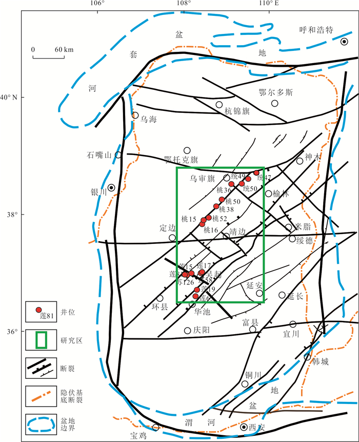
Taking the Member-5 of Ordovician Majiagou Formation in the central Ordos basin as an example, the relationship between migration direction of natural gas and faulting activities was investigated based on integrated observations of fluid inclusion petrology, laser-Raman spectroscopy, homogenization and ice melting temperature measurements, thermodynamic PVT simulation. The results indicate that the minerals in the veins of structural fractures are calcite, dolomite and magnesite. There are four types of fluid inclusions found in the veins, including methane-rich gas inclusions, CO2-bearing and methane-rich gas inclusions, methane-bearing aqueous inclusions and brine aqueous inclusions. The homogenization temperatures of the methane-bearing fluid inclusions range from 130.1 to 179.6 ℃, while the homogenization temperatures of the brine aqueous inclusions at the same time as the methane-bearing fluid inclusions range from 112.3 to 173.3 ℃. Combined with the history of hydrocarbon generation and strata burial, the Early Cretaceous is the important period of natural gas accumulation for the Majiagou Formation in studied area. While, Early Cretaceous tectonic movement produced a large number of structural fractures by the northeast-oriented faults. As the fluid inclusions in veins recorded the fluids of natural gas migration, experimental results prove that structural fractures had been channels for the migration of natural gas. The trapping pressures of fluid inclusions and pressure coefficients show a decreasing trend from SW to NE along the faults, which implies that the methane-bearing fluids migrated along the NE-trending fault.


Paleo-uplifts with late hydrocarbon generation and relatively low maturity of source rock have become important targets for petroleum exploration in the Middle Yangtze region. Xuefeng uplift formed in Late Caledonian, covered by Cretaceous strata, has no clear exploration directions because of complex tectono-sedimentary evolution. In this paper, it focuses on the north part of Yuanma basin located in the north margin of Xuefeng paleo-uplift, two types of calcite vein samples were collected from Cambrian shale and Cretaceous rocks near the unconformity between Cambrian and Cretaceous, in order to discuss the paleo-fluid environment, source, and its significance for hydrocarbon-generation evolution, by comprehensive analysis of geochemical data and inclusions. The following results were obtained. (1) Cretaceous veins with similar carbon and oxygen isotope value to surrounding rocks have no noticeable Eu abnormality of REE, different from strong Eu positive anomaly in Cambrian veins, indicating the source of veins was Cretaceous and little influenced by Cambrian shale. (2)Most inclusions in Cretaceous samples collected from structurally high position are aqueous inclusions, formed in weakly oxic to weakly reducing environment, with no bitumen or pure methane inclusions, indicating that the Cretaceous sediment was formed later than the time of large-scale hydrocarbon generation and expulsion of Cambrian shale. (3) Under the restrains of homogeneous temperature of fluid inclusions and Ro, two types burial history of Cambrian shale are proposed in Yuanma basin combined with regional geological characteristics. In Caotang depression, north of Yuanma basin, Cambrian shale has no secondary hydrocarbon generation due to deeply buried in early stage. However, the Chenxi depression in the south part may be a favorable area for shale gas exploration, where the Cambrian shale was shallow buried in early stage, and its Ro elevated form 1.2% to 2.5% in Cretacous buried stage leading to huge hydrocarbon potential.


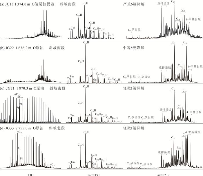
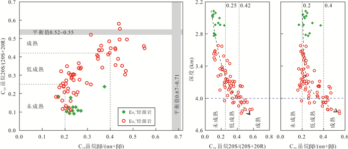
In order to investigate the oil and gas sources of buried hill reservoirs in Shulu sag, the hierarchical cluster analysis (HCA) is used to divide the main source rock, and oil-source correlation is achieved through the comparison of biomarker and oil-rock maturity. The results show that the buried hill oils have similar geochemical characteristics on the whole, indicating that they come from the same set of source rock. The organic matter of Es1x source rock is dominated by algae and plankton, which is deposited in salt water and strong reduction environment and is in the stage of immature to low maturity. While the organic matter of Es3x source rock is mainly mixed input of plankton and higher plants, which is deposited in fresh-brine water, weak-oxidation and weak-reduction environment, and its maturity increases with the increase of depth. The Es3x source rock is further subdivided into four types: A, B, C, and D, and type D is the most favorable type. Comparison of biomarker and oil-rock maturity indicate that crude oils in buried hill reservoirs are mainly derived from Es3x source rock, of which oils in the slope buried hill are mainly derived from shallow low-mature Es3x source rock at the edge of the depression, and oils in the high-in-sag are mainly derived from deep high-over mature Es3x source rock in the center of the depression.


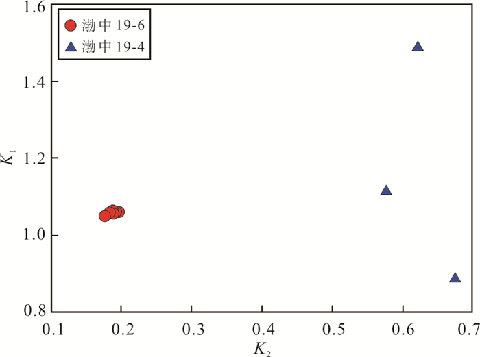
In order to clarify the geochemical characteristics and genesis of Bozhong 19-6 gas field in Bohai Bay basin, seven condensate oil samples from buried hill condensate gas reservoir in the study area are selected to conduct the whole-oil GC-MS test, and the light hydrocarbon composition characteristics are analyzed, and the geological application of light hydrocarbon parameters in the area were discussed. The results show that the Mango light hydrocarbon parameters K1 and K2 of Bozhong19-6 condensate oil are relatively stable, indicating that the genetic types of crude oil in the study area have good consistency. The C6-C8 compound component n-alkane has significant advantages, and the average methylcyclohexane index is 39%. Heptane value, isoheptane value and the ratio of n-heptane/methylcyclohexane (F) corresponds to high maturity. According to light hydrocarbon temperature parameters, the hydrocarbon generation temperature is 125.8-128.1 ℃, lower than the actual value maybe due to the phase change of condensate during sampling. The ratio of 2MP/3MP and 2MH/3MH in condensate oil is relatively high, while the K2 value is low. The molar concentration of n-paraffins in condensate oil is distributed in three stages, and the content of toluene/n-heptane and crude oil wax increases with depth. Furthermore, combined with the saturated hydrocarbon parameters and adamantane parameters, it is revealed that the oil and gas in Bozhong 19-6 buried hill were formed in the high mature stage (Ro=1.05%-1.30%) of lacustrine sapropel type Ⅱ1, which is adjusted by fractionation.


The lacustrine shale in the Da'anzhai Member of Ziliujing Formation of Lower Jurassic in Central Sichuan has strong heterogeneity, and the study of favorable lithological combinations is critical to the selection of the target interval. Through the observation and description of cores of more than 21 wells, the determination of organic matter contents and major and trace elements, it classifies lithological combinations and discusses the characteristics of each type. The results show that the shale strata of Da2 sub-member mainly developed three types of lithology: muddy shell limestone, gray-black shale, and shell-bearing shale. Then, according to the characteristics of its biological shell development, the special shell-rich layer was identified. Furthermore, it summarizes 4 types of lithological sections: A massive shell limestone section, B shale and shell-rich layer interbedded section, C shale intercalated shell-rich layer section, D pure shale section. The differences in paleoenvironmental characteristics of the 4 lithological sections types reflect different shale oil potentials. Therefore, comprehensive analysis indicates that from semi-humid to humid paleoclimate, high paleoproductivity, suitable deposition rate, as well as anoxic reduction, brackish-freshwater environment are conducive to the enrichment and preservation of organic matter. Finally, the favorable lithology section types as C shale intercalated shell-rich layer section were comprehensively optimized, followed by D pure shale section.


Yangjiang sag, as a secondary negative structural unit in Zhu Ⅲ depression, a shallow water marginal basin in the northwest of Pearl River Mouth Basin, has peripheral apophysis belt and local uplift barrier environment. Volcanic activities developed on both sides of Yangjiang-Yitong fault zone during Miocene (19.1-13.8 Ma), developing the background of the semi-closed tidal-controlled coastal-estuary restricted by the harbour geomorphology in the study area. Most of the mature explorations in Zhu Ⅲ depression are structural traps, but the research on the identification and characterization of lithologic traps is still in its infancy. Six oil-bearing structures were found in Yangjiang sag, and 19 wells were deployed, which has a good data base. There is a lack of systematic study on lithologic potential in Miocene series, meanwhile, the search, sorting and optimization of stratigraphic lithologic traps have not been carried out urgently. Moreover, the favorable oil accumulation zones are unknown. Therefore, the research and prediction significance of tidal sand dam are also major feature of this paper. Therefore, based on the regional tectonic volcanic activity background, in this paper, it focuses on the development and sedimentary characteristics of tidal control system, plane distribution and evolution law of sedimentary facies in Yangjiang sag based on the regional tectonic volcanic activity background, focusing on the development and sedimentary characteristics of tidal control system, the plane distribution and evolution of sedimentary facies, and then studies the lithosphere under the tidal control system. At the same time, it is found that several sets of reservoir sandbodies in EP20-8 traps identified in this paper are isolated tidal sand dam. The development and identification of closures, especially the predictive significance of tidal sand dam, are expected to provide reference for the identification and exploration of lithologic traps in shallow water area of Pearl River Mouth basin. It also provides a reference for the study of lithologic traps in other shallow marginal basins.


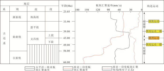
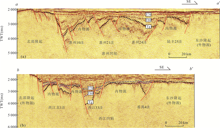
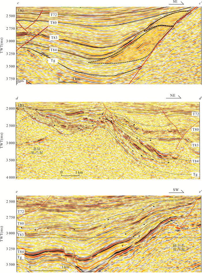
The reservoirs developed in the two sets of high-quality hydrocarbon-generating layers in the deep Paleogene of the Zhuyi depression have the advantages of near-source accumulation, but their characteristics of strong heterogeneity, low porosity and permeability have restricted oil and gas exploration. The directly related source-to-sink system is of great significance for finding a favorable area for coupling of hydrocarbon-rich and optimal reservoirs. Based on the influence of regional tectonic movements, and combining the structural characteristics of the rift lake basin with the semi-submarine ridge as its basic unit, source-to-sink system is divided into three levels of basin-level, half-graben-level, and zone-level. Basin-level source-to-sink system is further divided into external and internal source types, which can be used to analyze the distribution of high-quality source rocks; half-graben-level source-to-sink system is further classified into steep slopes, gentle slopes, and long-axis types, which is of great significance to qualitative evaluation of reservoir quality; zone-level source-to-sink system is further divided into three types of migration, conversion, and stability, which provides a good reference for target evaluation and well selection in favorable areas. It is considered that migration-type and conversion-type source-to-sink system can form a good configuration of high-quality source rocks and reservoirs, and are the most favorable oil and gas enrichment areas, which should be the focus of Paleogene exploration.


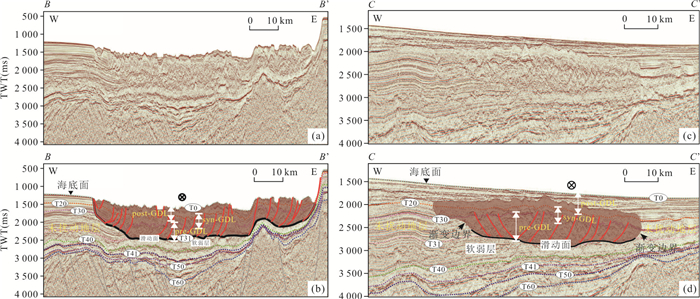
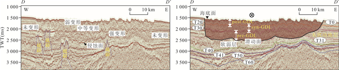
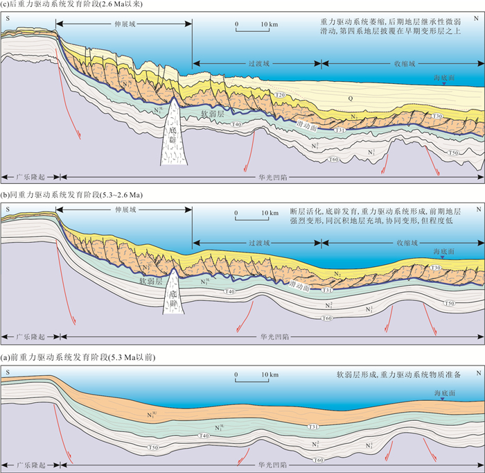
The study on submarine gravity-driven system (SGDS) is of great significance to understand the stability of submarine slope and the deep-water sedimentary processes. A large-scale SGDS sliding from south to north developed in the upper Miocene and above strata in the Huaguang depression of the Qiongdongnan basin, northern margin of the South China Sea. Based on regional 2D seismic data, in this paper it describes the characteristics of seismic facies and development of this large-scale SGDS and discusses its genetic mechanism. The development of the SGDS, composed of five elements including extensional domain, transitional domain, contractional domain, sliding surface and weak layer, could be divided into three stages as follows: the Late Miocene pre-gravity-sliding stage, the Pliocene syn-gravity-sliding stage, and the Quaternary post-gravity-sliding stage. During the fore-gravity-sliding stage, the channel complex was deposited on the bathyal argillaceous slope, and served on the material basis for gravity sliding. During the syn-gravity-sliding stage, which is the main stage of the SGDS development, the sediments were draped on the topography caused by intense deformation, and at the same time, there was also a certain degree of deformation. During the post-gravity-sliding stage, meaning the shrinking of the SGDS, the sediments gradually filled up the topography caused by gravity sliding and continued to deposit. It is indicated that the slope topography and high-speed sediment supply is the basis for the development of the SGDS, and the activation of basement faults and diapirism may be the trigger for its development.


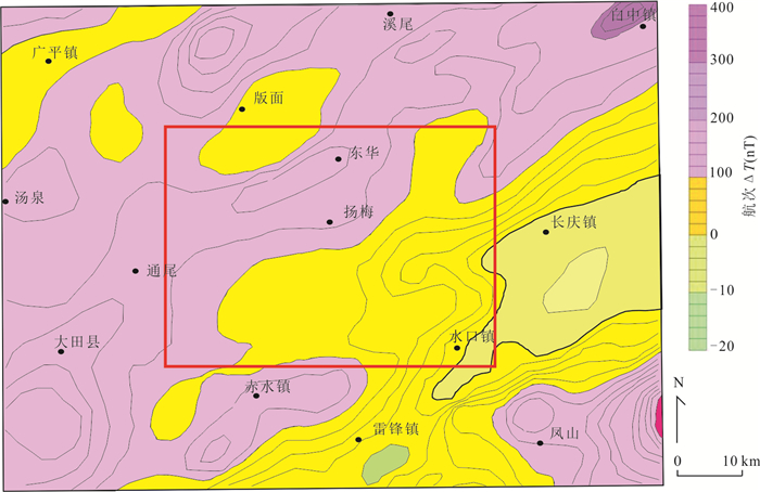
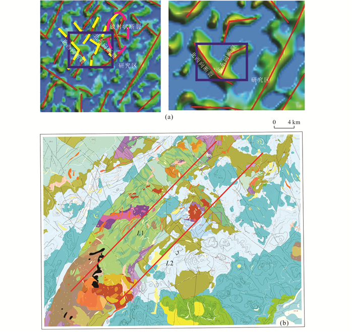
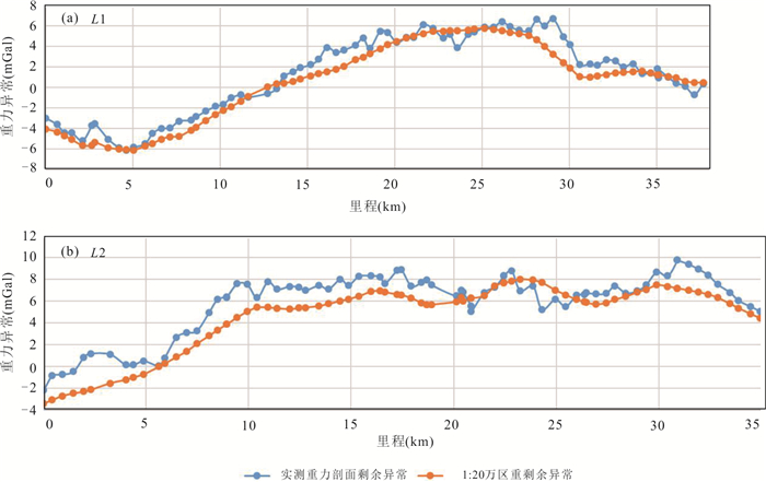
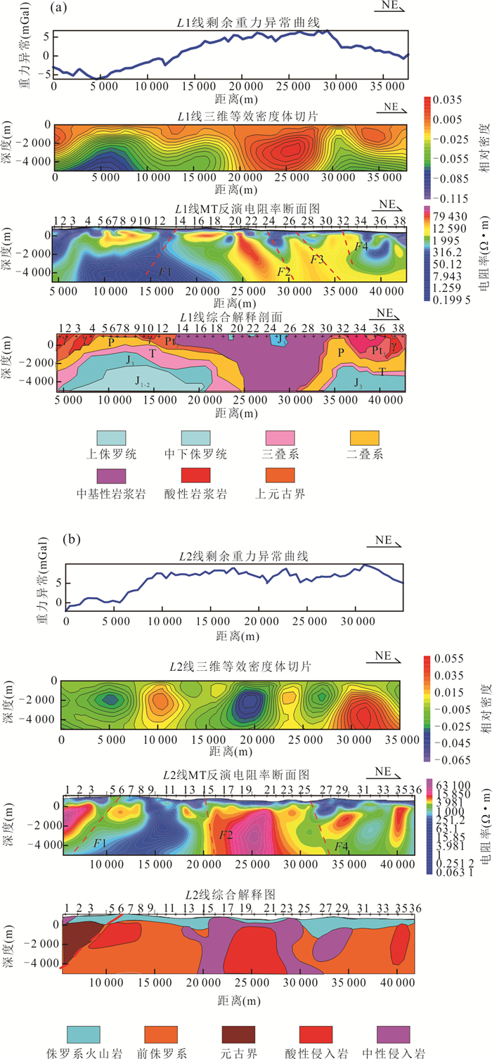
In order to study the deep geological structure of Dongyang region, it carried out the integrated geophysical exploration in Dongyang region, analyzed the geophysical field. Combined with the existing geological data, it analyses and studies the characteristics of regional geophysical field and regional deep geological structure. The conclusion is that the Dongyang region is located in the southwest of the outer ring of the giant ring structure. The study area is located in the transition area between the eastern coastal magnetic field violent change zone and the western inland magnetic field relatively gentle zone, and the regional aeromagnetic ΔT anomaly is mainly NE trending banded anomaly zone. There are two high residual gravity anomalies in the study area. The comprehensive geophysical section is divided into three parts by two NW trending deep faults. Combined with regional geological characteristics, it infers that the southern part of the area is a set of nappe rootless metamorphic rock series with high resistivity, the deep part is a set of Mesozoic sedimentary rocks with low resistivity, the shallow part of the northern part of the area is mainly composed of Mesozoic sedimentary rocks with thin volcanic rocks, the deep part is the high resistivity body of the Lower Paleozoic and Proterozoic basement rock series, and the central part of the area is the main development area of volcanic rocks.


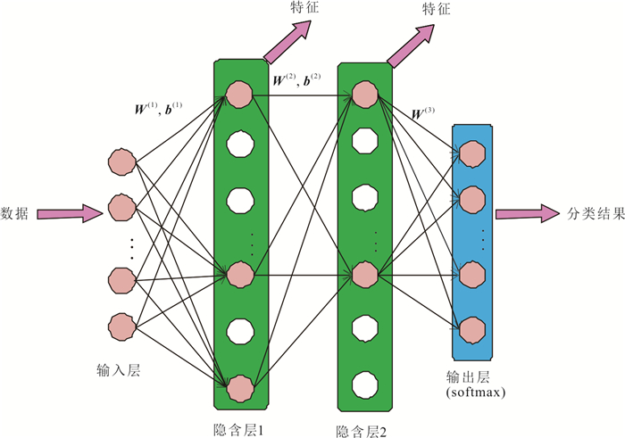
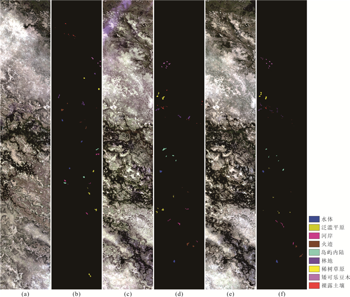
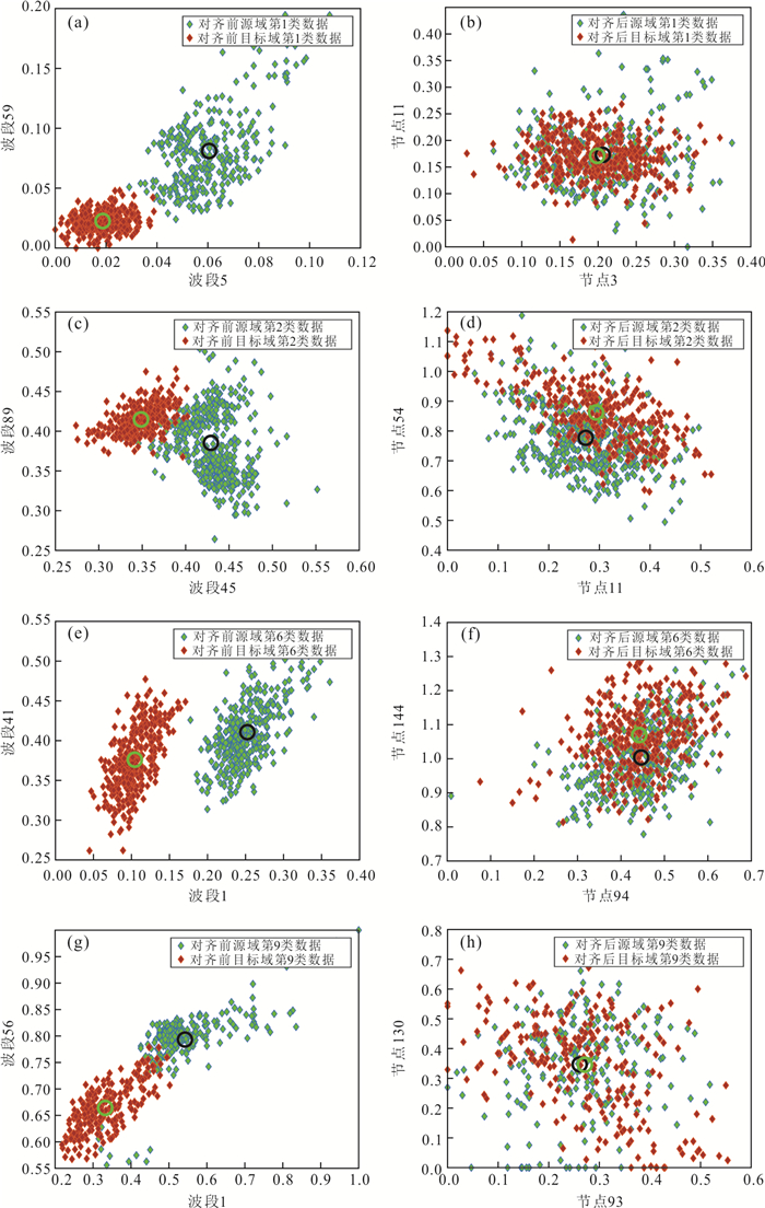
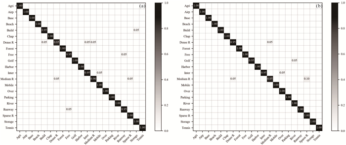
A transfer neural network based on feature alignment is proposed for classification of multi-temporal remote sensing image. In the network, the mean vector and covariance matrix of the sample data of each class are used to describe the data distribution, and the domain shift in terms of the first and second statistics can be reduced. In addition, rectified linear unit is utilized as the activation function, which can produce sparse features and improve the classification performance. In the transfer neural network, both aligned features and adaptive classifiers can be obtained simultaneously and unsupervised domain adaptation is achieved when there is no labeled data in the target image. The experimental results of multi-temporal Hyperion hyperspectral remote sensing images and WorldView-2 multispectral remote sensing images demonstrate the effectiveness of the proposed transfer neural network.


Scene classification of high-resolution remote sensing images has always been a research hotspot in the field of remote sensing. In view of the diversity of scale requirements of remote sensing scenes, in this paper it proposes a remote sensing image scene classification method based on multi-scale cyclic attention network. Firstly, the features of multiple scales of remote sensing scene image are extracted by Resnet50 network, the attention mechanism is used to obtain the region of interest of the image, and the region of interest is clipped and scaled. Then, the features of different scales of the original image and the features of different scale cropped images are fused, input to the full connection layer for classification prediction. The proposed method is validated in UC Merced Land-Use and NWPU-RESISC45, the average classification accuracy is improved by 1.89% and 2.70% respectively compared with Resnet50.The results show that the multi-scale cyclic attention network can further improve the accuracy of remote sensing image scene classification.


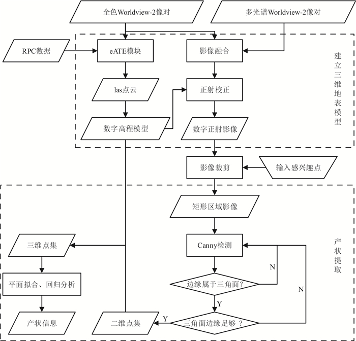
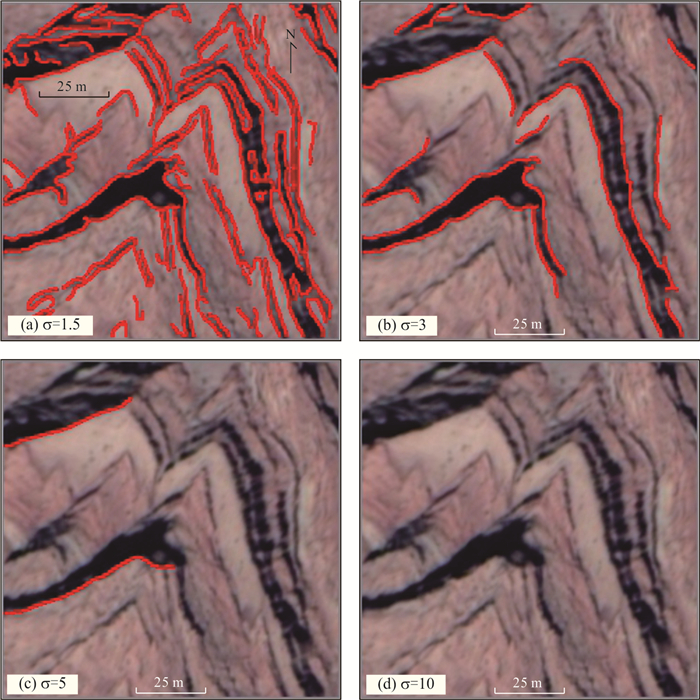
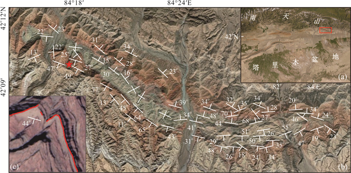
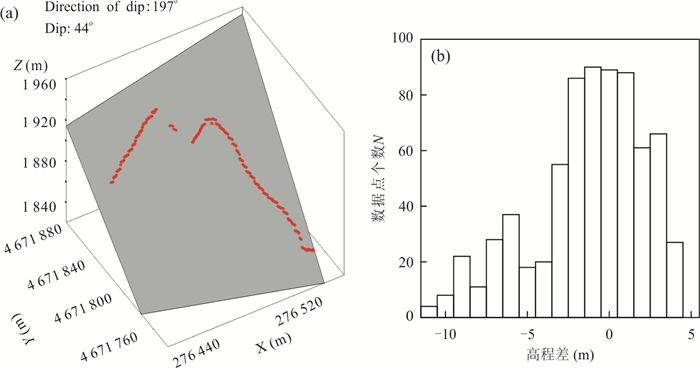
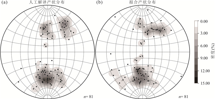
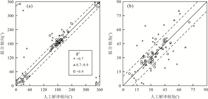
Accurate identification and rapid detection of triangular facet is an effective way to use remote sensing technology to obtain stratum attitude information. In this paper, it proposes a method for semi-automatic detection of triangular facet and rapid extraction of bedding attitude. Using high-resolution satellite remote sensing stero image pairs, the method is based on Canny edge detection algorithm with an automatic iterative adjustment of Gaussian distribution model variance. Taking Tugerming anticline in the South Tianshan Mountains as the experimental area, a digital elevation model and digital orthophoto maps with the resolution of 0.5 m were constructed using Worldview-2 stereo pairs, and 81 triangular facets in the experimental area were extracted. The result shows that the method proposed in this paper is objective and efficient, and the extraction accuracy rate reaches 90.2%. The extracted attitude accurately reflect the changes in structure, providing a basis for surface modeling and structural analysis of complex structural belts.


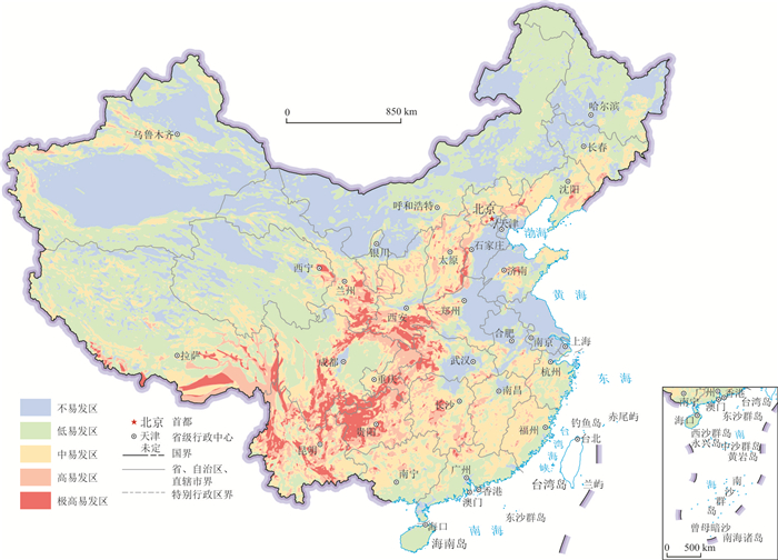
The geological environment safety evaluation is becoming increasingly more important in land planning since the geological environment is getting more complicated in recent years. Based on summarizing the previous comprehensive evaluation of geological environment, a comprehensive evaluation index system of geological environment safety is established and a comprehensive evaluation method thereof is developed to provide scientific basis and technical support for land planning and evaluation of resources and environment carrying capacity. The connotation of geological environment safety is put forward, and three key factors for geological environmental safety evaluation are determined as regional crust stability, susceptibility of geologic hazards, and susceptibility of chronic geologic hazards, which are evaluated respectively. Five grades and twelve classes are divided through comprehensive evaluation of geological environment safety by using a comprehensive way to evaluate the dominant factors. The evaluation results not only reflect the degree of geological environment safety, but also explain the key factors affecting the geological environment safety. The area of overlapping regions, where the regional structure is extremely unstable and unexpected geological hazards are especially easy to occur, accounts for about 4.24%, mainly distributed in the eastern margin of the Tibetan plateau, mainly involving Gansu Baiyin-Tianshui, Sichuan Deyang-Kangding-Xichang, Yunnan Dongchuan-Gejiu, southern Tibet and western Yunnan areas. The results of geological environment safety evaluation enhance the understanding on geological environment, and the degree of geological environment safety, as one of the indicators of land planning, provides technical support and scientific basis for land planning.


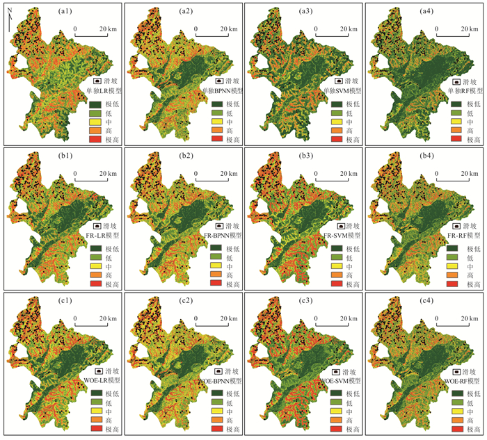
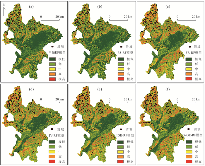
This study aims to explore the influences of some modeling factors including the non-linear correlation calculation between landslides and environmental factors and the different data-based models on the uncertainty law of landslide susceptibility prediction (LSP) modeling. The Ruijin City of Jiangxi Province in China with investigated 370 landslides and 10 environmental factors is used as study case. Accordingly, a total of 20 types of different coupling modeling conditions are proposed for LSP with five different connection methods(probability statistics (PS), frequency ratio (FR), information value (Ⅳ), index of entropy (IOE) and weight of evidence (WOE)) and four different data-based models including logistic regression (LR), back propagation neural networks (BPNN), support vector machines (SVM) and random forest (RF). Meanwhile, four single LR, BPNN, SVM and RF models with the original data as input variables are also proposed, as a whole, a total of 24 types of modeling conditions for LSP are obtained based on the above 20 types of coupling conditions and 4 types of single models. Finally, the uncertainty characteristics in the LSP modeling are assessed using the area under the receiver operation curve (ROC), mean value, standard deviation and significance test, respectively. Results show follows. (1) WOE-based models have the highest LSP accuracy and low uncertainty while PS-based models have the lowest LSP accuracy and the highest uncertainty, and the FR, Ⅳ and IOE-based models are in between. (2) The single data-based models have slightly lower LSP accuracies than those of the coupling models on the whole and cannot calculate the influence law of each sub-interval of environmental factors on landslide evolution, however, the single data-based models have higher modeling efficiency than those of the coupling models. (3) Among all the data-based models, RF model has the highest LSP accuracy and relatively low uncertainty, followed by the SVM, BPNN and LR models, respectively. It is concluded that the WOE is a very excellent correlation method and the RF model predicts the optimal LSP performance, the LSP results of WOE-RF model have the lowest uncertainties and the predicted landslide susceptibility indexes are more consistent with the actual landslides distribution characteristics.


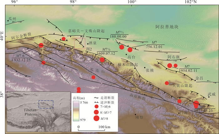
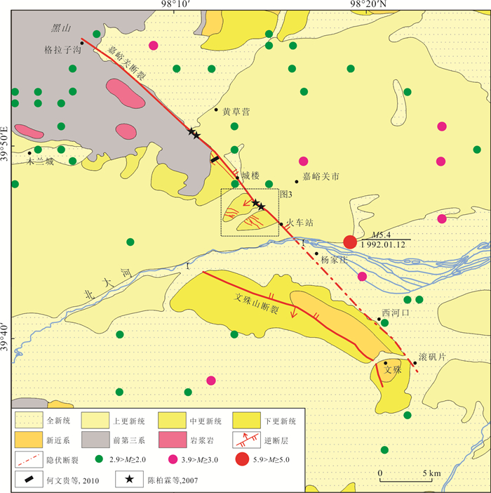
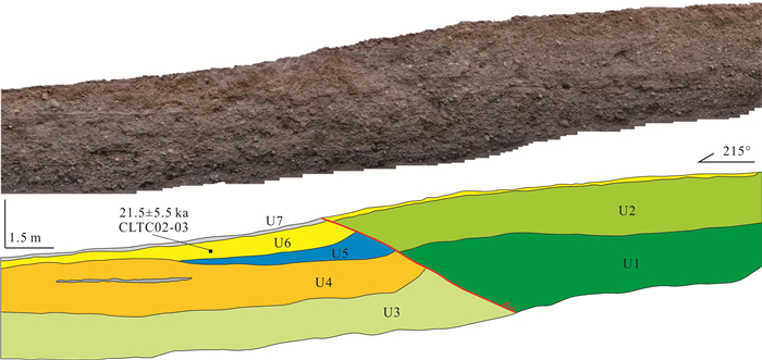
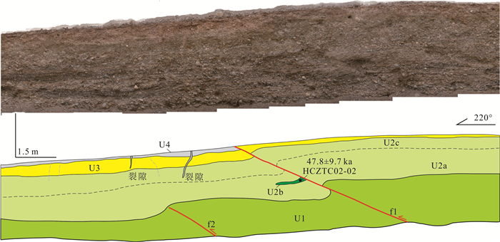
The Jiayuguan fault lies in the western part of the Hexi Corridor, which is a boundary fault between the Jiuxi basin and Jiudong basin. Its latest active characteristics and strong earthquake risk are related to the earthquake disaster of Jiayuguan area and related cultural relics. Based on the interpretation of high-resolution satellite images and field investigation, it is found that the middle segment of the Jiayuguan fault is composed of multiple branch faults. The paleoseismic characteristics of the fault are studied by means of paleoseismical trenching and optical stimulated luminescence (OSL) dating. The results show that the latest earthquake event on the Jiayuguan fault occurred at 4.3-5.3 ka, and three other events occurred approximately at 20.0-21.2 ka, 37.0-45.0 ka and 58.1 ka. According to the empirical relationship, the Jiayuguan fault has the potential and risk for strong earthquake of Mw 7.0. Under this magnitude, the seismic intensity of Jiayuguan tower area will be up to Ⅸ, and the Jiayuguan urban area will be Ⅷ. Therefore, the Jiayuguan fault is an important seismogenic fault in this area.