2021 Vol. 46, No. 11
Display Method:
 PDF 495KB
2021, 46(11): 3807-3817.
doi: 10.3799/dqkx.2021.002
Abstract:
Tellurium (Te) belongs to dispersed elements, and is one of the strategic key mineral resources in China. Telluride-rich gold deposits are important carriers of tellurium. In this study, telluride-rich gold deposits are divided into three genetic types: orogenic gold deposits, epithermal gold deposits, and alkaline magmatic rock-related gold deposits. Telluride-rich gold deposits are developed in island arc, continental margin, back-arc basin, greenstone belt and other tectonic environments, usually restricted by regional faults. The wall rocks show a lot of varieties. Different types of tellurides coexist with natural gold and sulfides. The Au-Te mineralization process can be usually divided into three stages: quartz-pyrite stage, quartz-polymetallic sulfide-telluride stage, and quartz-carbonate stage. Gold and tellurium are mainly enriched in the second stage. The ore-forming fluids are characterized by medium-low temperature, medium-low salinity, weakly acidic to neutral, with high fTe2. Tellurium is mainly originated from the mantle, magmatic hydrothermal solutions, and host rocks. Tellurium can migrate in the form of Te-Cl, Te-S, and Te-H complexes in fluids as well as vapors. Precipitation of telluride can be resulted from the change of temperature or/and pressure, water-rock reaction, fluid mixing, fluid immiscibility (boiling), condensation of Te-bearing gases, and the superposition of multiple factors. In-situ micro-analysis of the structure and composition of tellurides, Te isotopic analysis, and thermodynamic analysis are prospective ways to study the mineralization of tellurium.
Tellurium (Te) belongs to dispersed elements, and is one of the strategic key mineral resources in China. Telluride-rich gold deposits are important carriers of tellurium. In this study, telluride-rich gold deposits are divided into three genetic types: orogenic gold deposits, epithermal gold deposits, and alkaline magmatic rock-related gold deposits. Telluride-rich gold deposits are developed in island arc, continental margin, back-arc basin, greenstone belt and other tectonic environments, usually restricted by regional faults. The wall rocks show a lot of varieties. Different types of tellurides coexist with natural gold and sulfides. The Au-Te mineralization process can be usually divided into three stages: quartz-pyrite stage, quartz-polymetallic sulfide-telluride stage, and quartz-carbonate stage. Gold and tellurium are mainly enriched in the second stage. The ore-forming fluids are characterized by medium-low temperature, medium-low salinity, weakly acidic to neutral, with high fTe2. Tellurium is mainly originated from the mantle, magmatic hydrothermal solutions, and host rocks. Tellurium can migrate in the form of Te-Cl, Te-S, and Te-H complexes in fluids as well as vapors. Precipitation of telluride can be resulted from the change of temperature or/and pressure, water-rock reaction, fluid mixing, fluid immiscibility (boiling), condensation of Te-bearing gases, and the superposition of multiple factors. In-situ micro-analysis of the structure and composition of tellurides, Te isotopic analysis, and thermodynamic analysis are prospective ways to study the mineralization of tellurium.

2021, 46(11): 3818-3828.
doi: 10.3799/dqkx.2020.373
Abstract:
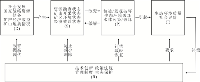
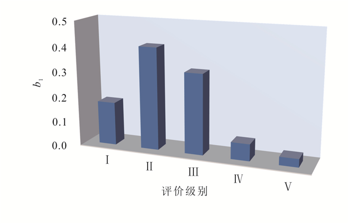
The accurate quantitative assessment, which is about economic value of mining and ecological impact of future exploration and development on the environment, is highly needed and it can help to alleviate the contradiction between the development of mineral resources and the construction of ecological civilization. Based on multivariate data, in this study it constructs a comprehensive evaluation index system with the DPSIR model (Driving-Pressure-State-Impact-Response) as the theoretical framework, including 6 first-level indicators and 23 second-level indicators. According to the evaluation rating table, a multi-level fuzzy comprehensive evaluation method is used to calculate the weight of the indicators and analyze the comprehensive average value to establish a complete evaluation system. The application of this system in the development of the Luoboling porphyry deposit in Fujian shows that the development suitability of the Luoboling mining area in Fujian is rated as Grade Ⅱ, that is, it plays a significant role in promoting local economic development, but it will produce slight environment negative impact. The evaluation system constructed in this study provides a practical method which can be referred for the development and evaluation of mineral resources by the different levels of government and mining enterprises.
The accurate quantitative assessment, which is about economic value of mining and ecological impact of future exploration and development on the environment, is highly needed and it can help to alleviate the contradiction between the development of mineral resources and the construction of ecological civilization. Based on multivariate data, in this study it constructs a comprehensive evaluation index system with the DPSIR model (Driving-Pressure-State-Impact-Response) as the theoretical framework, including 6 first-level indicators and 23 second-level indicators. According to the evaluation rating table, a multi-level fuzzy comprehensive evaluation method is used to calculate the weight of the indicators and analyze the comprehensive average value to establish a complete evaluation system. The application of this system in the development of the Luoboling porphyry deposit in Fujian shows that the development suitability of the Luoboling mining area in Fujian is rated as Grade Ⅱ, that is, it plays a significant role in promoting local economic development, but it will produce slight environment negative impact. The evaluation system constructed in this study provides a practical method which can be referred for the development and evaluation of mineral resources by the different levels of government and mining enterprises.
2021, 46(11): 3829-3849.
doi: 10.3799/dqkx.2021.015
Abstract:
The East Tianshan is situated along the southern margin of the Central Asian Orogenic Belt, and its outcrops of a series of important magmatic Ni-Cu sulfide deposits hosted by mafic-ultramafic intrusions are the focus of recent studies. In this study, it presents a systematic study of petrology, mineralogy and geochemistry of the Huangshannan sulfide ore-bearing mafic-ultramafic intrusion of the East Tianshan region, in order to further discuss the origin and nature of its parental magma. The Huangshannan intrusion consists of an ultramafic unit, which is composed of harzburgite, lherzolite and olivine websterite, and a mafic unit, which is composed of (olivine) gabbronorite and diorite. The rocks of the intrusion are characterized by enrichments of large ion lithophile elements, light rare earth elements and strong negative Nb-Ta, Ti anomalies, similar to that of typical arc volcanics. These rocks also have variable isotope compositions[εNd(t=282.5 Ma)=(-1.31)-4.22;(87Sr/86Sr)i=0.703 2-0.706 9;(206Pb/204Pb)i=17.67-18.90], indicating the parental magma was derived from a moderately enriched depleted mantle source and contaminated by 5%-20% juvenile arc crust and then by ~5% upper crustal materials. According to its highest Fo olivine, the estimated parental magma of the Huangshannan intrusion has 12.11% MgO, 11.14% FeOTotal and 306×10-6 Ni, indicating the picritic magma was generated from partial melting of both the asthenosphere and mantle wedge. The low Ca (< 725×10-6), 100×Mn/Fe (1.18-1.38) and high Ni (1 451×10-6-2 813×10-6), Mn/Zn (11.09-23.53) ratios of the Huangshannan olivines indicate the Huangshannan parental magma may be derived from pyroxenite in a modally enriched peridotite mantle source. Therefore, it speculates that the Huangshannan primary magmas were likely derived from a lithospheric pyroxenite mantle source as the result of slab-derived fluid modification during previous subduction.
The East Tianshan is situated along the southern margin of the Central Asian Orogenic Belt, and its outcrops of a series of important magmatic Ni-Cu sulfide deposits hosted by mafic-ultramafic intrusions are the focus of recent studies. In this study, it presents a systematic study of petrology, mineralogy and geochemistry of the Huangshannan sulfide ore-bearing mafic-ultramafic intrusion of the East Tianshan region, in order to further discuss the origin and nature of its parental magma. The Huangshannan intrusion consists of an ultramafic unit, which is composed of harzburgite, lherzolite and olivine websterite, and a mafic unit, which is composed of (olivine) gabbronorite and diorite. The rocks of the intrusion are characterized by enrichments of large ion lithophile elements, light rare earth elements and strong negative Nb-Ta, Ti anomalies, similar to that of typical arc volcanics. These rocks also have variable isotope compositions[εNd(t=282.5 Ma)=(-1.31)-4.22;(87Sr/86Sr)i=0.703 2-0.706 9;(206Pb/204Pb)i=17.67-18.90], indicating the parental magma was derived from a moderately enriched depleted mantle source and contaminated by 5%-20% juvenile arc crust and then by ~5% upper crustal materials. According to its highest Fo olivine, the estimated parental magma of the Huangshannan intrusion has 12.11% MgO, 11.14% FeOTotal and 306×10-6 Ni, indicating the picritic magma was generated from partial melting of both the asthenosphere and mantle wedge. The low Ca (< 725×10-6), 100×Mn/Fe (1.18-1.38) and high Ni (1 451×10-6-2 813×10-6), Mn/Zn (11.09-23.53) ratios of the Huangshannan olivines indicate the Huangshannan parental magma may be derived from pyroxenite in a modally enriched peridotite mantle source. Therefore, it speculates that the Huangshannan primary magmas were likely derived from a lithospheric pyroxenite mantle source as the result of slab-derived fluid modification during previous subduction.


2021, 46(11): 3850-3860.
doi: 10.3799/dqkx.2021.012
Abstract:
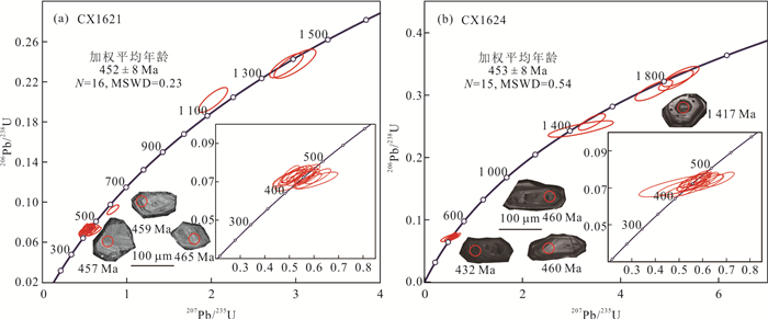
In order to decipher the Early Paleozoic tectonic evolution of the northwestern Hainan Island, detailed petrography and zircon U-Pb geochronological analyses of andesites in the Bangxi-Chenxing area were carried out in this study. The andesites are mainly composed of plagioclase, hornblende, biotite and glasses. LA-ICP-MS zircon U-Pb dating results show that two representative andesite samples yield ages of 452±8 Ma and 453±8 Ma, indicating that there is andesitic magmatism in the Bangxi-Chenxing area during the Early Paleozoic. The formation age of the andesites is similar to the time of Early Paleozoic magmatism recorded in the micro-continents along the northern Gondwana. They also show a good coupling with the Early Paleozoic igneous rocks in the Jinshajiang-Diancangshan-Ailaoshan tectonic belt and in the Indochina block. Integrated with regional data, the Diancangshan-Ailaoshan, Truong Son, Tam Ky-Phuoc Son, Kontum and Hainan Island were likely to be branch of Proto-Tethys Oceans during the Early Paleozoic.
In order to decipher the Early Paleozoic tectonic evolution of the northwestern Hainan Island, detailed petrography and zircon U-Pb geochronological analyses of andesites in the Bangxi-Chenxing area were carried out in this study. The andesites are mainly composed of plagioclase, hornblende, biotite and glasses. LA-ICP-MS zircon U-Pb dating results show that two representative andesite samples yield ages of 452±8 Ma and 453±8 Ma, indicating that there is andesitic magmatism in the Bangxi-Chenxing area during the Early Paleozoic. The formation age of the andesites is similar to the time of Early Paleozoic magmatism recorded in the micro-continents along the northern Gondwana. They also show a good coupling with the Early Paleozoic igneous rocks in the Jinshajiang-Diancangshan-Ailaoshan tectonic belt and in the Indochina block. Integrated with regional data, the Diancangshan-Ailaoshan, Truong Son, Tam Ky-Phuoc Son, Kontum and Hainan Island were likely to be branch of Proto-Tethys Oceans during the Early Paleozoic.

2021, 46(11): 3861-3879.
doi: 10.3799/dqkx.2020.385
Abstract:
The Chongshan metamorphic complex belt in West Yunnan is located in the northern part of "peak waist" of Sanjiang orogenic belt. The tectonic compression metamorphism in the belt is strong, and the main body is composed of a suite of medium-deep grade metamorphic rocks (Chongshan Group) and late granite.Among them, Chongshan Group has always been regarded as the crystalline basement of Proterozoic, but so far there is no accurate age basis, and its formation time and tectonic attributes are controversial, which seriously restricts the understanding of regional tectonic evolution.In this paper, the detrital zircon U-Pb geochronology and petrogeochemistry of the rock components in Chongshan Group in Caojian area, West Yunnan Province were studied. The results show that the zircons in the parametamorphic rocks have obvious rounded features and large magmatic nuclei.The smallest group of detrital zircon ages of the three samples are 366-412 Ma (mean value 395 Ma), 435-508 Ma (mean value 473 Ma) and 673-704 Ma (mean value 689 Ma), respectively, indicating that their original sedimentary age should be no earlier than 395 Ma. Rock geochemistry shows that the meta-metamorphic rocks are a set of continental island arc clastic rocks related to the tectonic setting of active continental margin or passive continental margin, and the metamorphic mafic rocks and metamorphic intermediate rocks are homologous and heterogeneous and have the characteristics of arc volcanic rocks of active continental margin.Retrogeochemistry shows that the meta-metamorphic rocks are a set of continental island arc clastic rocks related to the tectonic setting of active continental margin or passive continental margin, and the metamorphic basic rocks and metamorphic intermediate rock are homologous and heterogeneous and have the characteristics of arc volcanic rocks of active continental margin.The main body of Chongshan Group is a set of volcanic-sedimentary stratigraphic units which were diagenetic in the Late Paleozoic (236- 395 Ma) and formed in the marginal arc environment. It is combined with Silurian arc volcanic rocks of Lancang River accretion complex in the south east side to form the structural pattern of multi-island arcs in different times on the east side of the Proto- Paleo-Tethys ocean basin. According to comprehensive research, the medium-deep grade metamorphic rocks(Chongshan Group) in Chongshan metamorphic complex belt is not (all) a Proterozoic crystalline basement, but a volcanic-sedimentary stratigraphic system formed by the subduction of the original-Paleo-Tethys ocean basin eastward on the western edge of Lanping-Simao block.Chongshan Group is mainly composed of young (Late Paleozoic) stratigraphic rocks, which formed the medium-deep grade metamorphic rocks with "old" rock features after being subjected to Mesozoic and Cenozoic metamorphism and deformation in the later period.
The Chongshan metamorphic complex belt in West Yunnan is located in the northern part of "peak waist" of Sanjiang orogenic belt. The tectonic compression metamorphism in the belt is strong, and the main body is composed of a suite of medium-deep grade metamorphic rocks (Chongshan Group) and late granite.Among them, Chongshan Group has always been regarded as the crystalline basement of Proterozoic, but so far there is no accurate age basis, and its formation time and tectonic attributes are controversial, which seriously restricts the understanding of regional tectonic evolution.In this paper, the detrital zircon U-Pb geochronology and petrogeochemistry of the rock components in Chongshan Group in Caojian area, West Yunnan Province were studied. The results show that the zircons in the parametamorphic rocks have obvious rounded features and large magmatic nuclei.The smallest group of detrital zircon ages of the three samples are 366-412 Ma (mean value 395 Ma), 435-508 Ma (mean value 473 Ma) and 673-704 Ma (mean value 689 Ma), respectively, indicating that their original sedimentary age should be no earlier than 395 Ma. Rock geochemistry shows that the meta-metamorphic rocks are a set of continental island arc clastic rocks related to the tectonic setting of active continental margin or passive continental margin, and the metamorphic mafic rocks and metamorphic intermediate rocks are homologous and heterogeneous and have the characteristics of arc volcanic rocks of active continental margin.Retrogeochemistry shows that the meta-metamorphic rocks are a set of continental island arc clastic rocks related to the tectonic setting of active continental margin or passive continental margin, and the metamorphic basic rocks and metamorphic intermediate rock are homologous and heterogeneous and have the characteristics of arc volcanic rocks of active continental margin.The main body of Chongshan Group is a set of volcanic-sedimentary stratigraphic units which were diagenetic in the Late Paleozoic (236- 395 Ma) and formed in the marginal arc environment. It is combined with Silurian arc volcanic rocks of Lancang River accretion complex in the south east side to form the structural pattern of multi-island arcs in different times on the east side of the Proto- Paleo-Tethys ocean basin. According to comprehensive research, the medium-deep grade metamorphic rocks(Chongshan Group) in Chongshan metamorphic complex belt is not (all) a Proterozoic crystalline basement, but a volcanic-sedimentary stratigraphic system formed by the subduction of the original-Paleo-Tethys ocean basin eastward on the western edge of Lanping-Simao block.Chongshan Group is mainly composed of young (Late Paleozoic) stratigraphic rocks, which formed the medium-deep grade metamorphic rocks with "old" rock features after being subjected to Mesozoic and Cenozoic metamorphism and deformation in the later period.


2021, 46(11): 3880-3891.
doi: 10.3799/dqkx.2020.397
Abstract:
The Tangjia-Sumdo Paleo-Tethys accretionary complex belt, recorded in the southeastern margin of Lhasa, provides new evidence for the understanding of the Late Paleozoic tectonic evolution of the Paleo-Tethys Ocean. In this paper, it reports new data for the felsic tuff in this accretionary complex belt, including petrology, major and trace element compositions, zircon U-Pb age, and in-situ Hf isotopic compositions. U-Pb zircon dating indicates that the timing of eruption of the Chongni tuffs was ca. 278-275 Ma. They are characterized by relatively high SiO2 (63.47%-72.65%), and high Al2O3 (14.53%-21.31%), relatively low K2O (1.30%-2.51%), TiO2 (0.50%-1.17%), MgO (0.92%-2.00%), and Mg# (19.9-34.2). These tuffs exhibit LILE enrichment and HFSE depletetion. The zircons participating in the weighted age calculation have positive εHf(t) values of +10.2 to +14.4 and relatively young zircon Hf crustal model ages (TDMc=351-621 Ma). It agrees that Chongni tuffs were derived from the partial melting of the juvenile crust under the background of the northward subduction of the Tangjia-Sumdo Paleo-Tethys Ocean slab, and the beginning time of the ocean slab subduction is not later than Early Permian, before which there were the events that crust grew in the southeastern margin of Lhasa.
The Tangjia-Sumdo Paleo-Tethys accretionary complex belt, recorded in the southeastern margin of Lhasa, provides new evidence for the understanding of the Late Paleozoic tectonic evolution of the Paleo-Tethys Ocean. In this paper, it reports new data for the felsic tuff in this accretionary complex belt, including petrology, major and trace element compositions, zircon U-Pb age, and in-situ Hf isotopic compositions. U-Pb zircon dating indicates that the timing of eruption of the Chongni tuffs was ca. 278-275 Ma. They are characterized by relatively high SiO2 (63.47%-72.65%), and high Al2O3 (14.53%-21.31%), relatively low K2O (1.30%-2.51%), TiO2 (0.50%-1.17%), MgO (0.92%-2.00%), and Mg# (19.9-34.2). These tuffs exhibit LILE enrichment and HFSE depletetion. The zircons participating in the weighted age calculation have positive εHf(t) values of +10.2 to +14.4 and relatively young zircon Hf crustal model ages (TDMc=351-621 Ma). It agrees that Chongni tuffs were derived from the partial melting of the juvenile crust under the background of the northward subduction of the Tangjia-Sumdo Paleo-Tethys Ocean slab, and the beginning time of the ocean slab subduction is not later than Early Permian, before which there were the events that crust grew in the southeastern margin of Lhasa.


2021, 46(11): 3892-3909.
doi: 10.3799/dqkx.2021.016
Abstract:
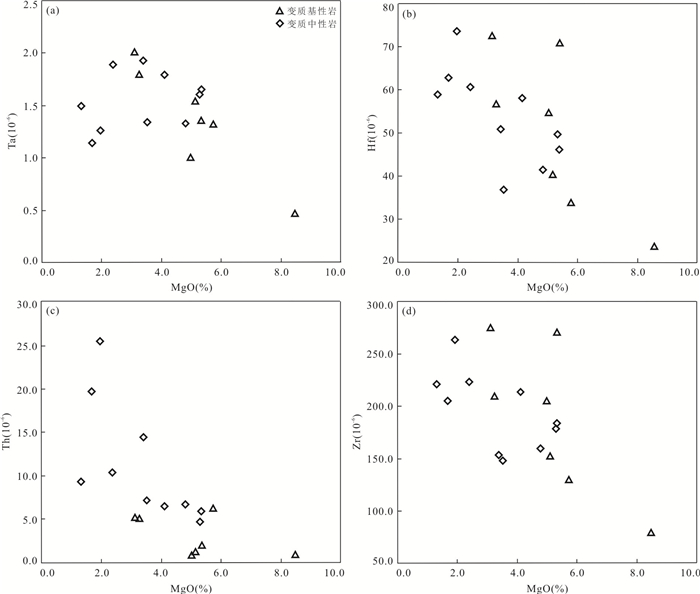
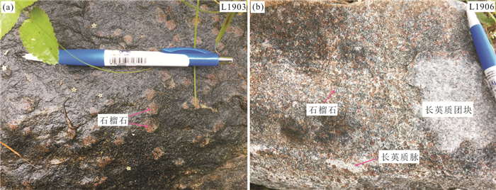
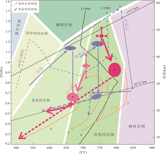
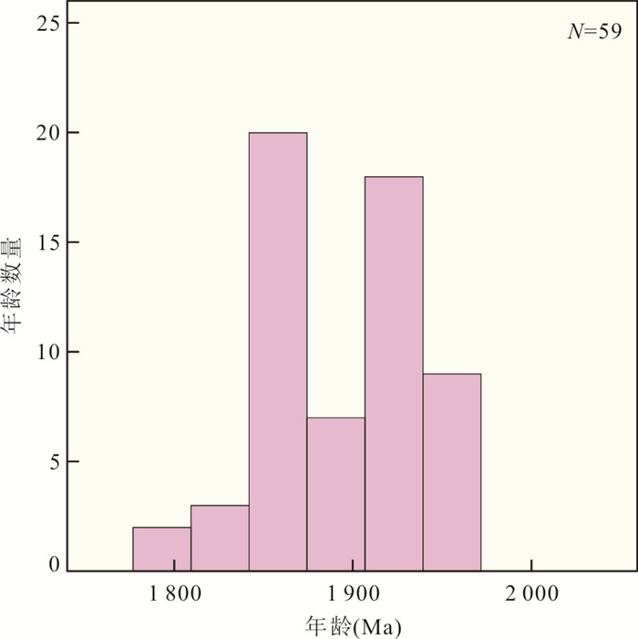
The Yunzhongshan terrane is situated in the middle segment of the Trans-North China Orogen, a key position connecting the Lüliang and Wutai-Hengshan terranes. Addressing its metamorphic evolution is of great importance in understanding the tectonic process of the Lüliang-Yunzhongshan-Wutai-Hengshan areas. Detailed studies of petrology, phase modelling and geochronology were carried out on garnet amphibolite from the Yunzhongshan terrane. Both samples exhibit clockwise P-T-t paths, which are characterized by rutile-bearing peak stages with P-T conditions of 0.96±0.11 GPa/720±8.0℃(L1903) and 1.26±0.08 GPa/756±14.0℃(L1906), respectively. The post-peak stages are dominated by decompression, accompanied by transition of rutile by ilmenite, growth of plagioclase (+hornblende) coronae surrounding garnet and transition of hornblende by cummingtonite. The late stages are dominated by cooling, with local metasomatism of garnet by chlorite. By comparing petrographical features and chemical compositions of the two samples, it can be concluded that the partial melting of garnet amphibolite is affected by the bulk-rock compositions. The rock is refractory when it is rich in Fe, Mg and Ti and poor in Si and Na. Zircon U-Pb dating yields metamorphic ages of 1 928-1 806 Ma, interpreted to represent the cooling stage of metamorphism. This is supported by high concentration of HREE in zircon grains and low crystallization temperatures of 520-680℃ calculated by Ti-in-zircon thermometer. Comparison of the overall geological characteristics of the Lüliang-Yunzhongshan-Wutai-Hengshan areas shows that the lithostratigraphic units and metamorphism evolution in the Yunzhongshan terrane are very similar to those in the Wutai-Hengshan terranes, which record the Late Paleoproterozoic collision orogeny.
The Yunzhongshan terrane is situated in the middle segment of the Trans-North China Orogen, a key position connecting the Lüliang and Wutai-Hengshan terranes. Addressing its metamorphic evolution is of great importance in understanding the tectonic process of the Lüliang-Yunzhongshan-Wutai-Hengshan areas. Detailed studies of petrology, phase modelling and geochronology were carried out on garnet amphibolite from the Yunzhongshan terrane. Both samples exhibit clockwise P-T-t paths, which are characterized by rutile-bearing peak stages with P-T conditions of 0.96±0.11 GPa/720±8.0℃(L1903) and 1.26±0.08 GPa/756±14.0℃(L1906), respectively. The post-peak stages are dominated by decompression, accompanied by transition of rutile by ilmenite, growth of plagioclase (+hornblende) coronae surrounding garnet and transition of hornblende by cummingtonite. The late stages are dominated by cooling, with local metasomatism of garnet by chlorite. By comparing petrographical features and chemical compositions of the two samples, it can be concluded that the partial melting of garnet amphibolite is affected by the bulk-rock compositions. The rock is refractory when it is rich in Fe, Mg and Ti and poor in Si and Na. Zircon U-Pb dating yields metamorphic ages of 1 928-1 806 Ma, interpreted to represent the cooling stage of metamorphism. This is supported by high concentration of HREE in zircon grains and low crystallization temperatures of 520-680℃ calculated by Ti-in-zircon thermometer. Comparison of the overall geological characteristics of the Lüliang-Yunzhongshan-Wutai-Hengshan areas shows that the lithostratigraphic units and metamorphism evolution in the Yunzhongshan terrane are very similar to those in the Wutai-Hengshan terranes, which record the Late Paleoproterozoic collision orogeny.


2021, 46(11): 3910-3925.
doi: 10.3799/dqkx.2020.379
Abstract:
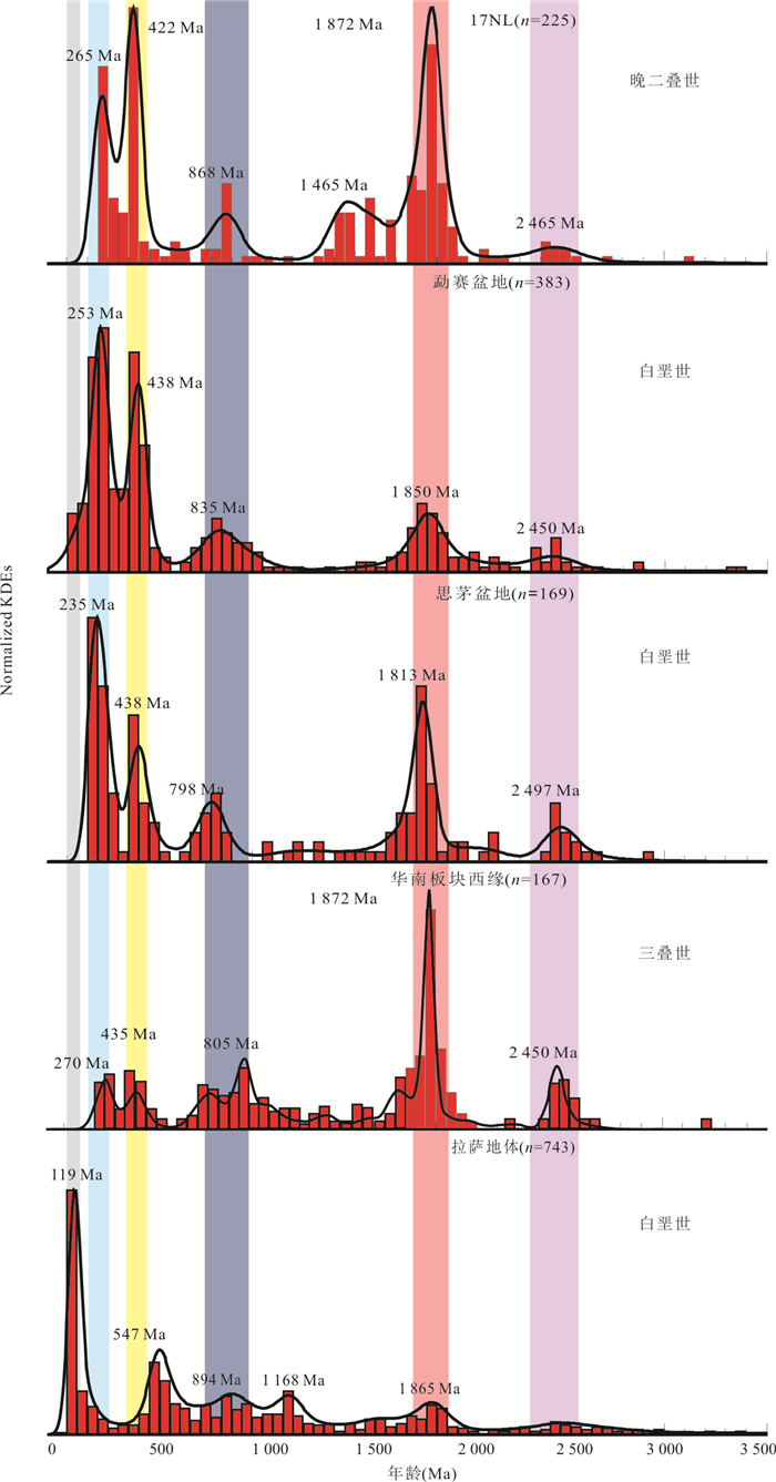
The sedimentary evolution history of Northwest Laos has not been well defined. Therefore, it studied the petrology, geochemistry and detrital zircon U-Pb geochronology systematically by using four sandstone samples collected from the well-exposed strata of Permian in NW Laos. Petrography shows that this set of samples mainly includes feldspathic quartz sandstone, lithic sandstone and greywacke. Whole-rock geochemical analyses suggest that these samples are characterized by high SiO2 (64.9%-91.2%), high Al2O3 content (5.0%-17.4%) and high CIA index (59.6-89.9), indicating that they have undergone moderate to strong weathering. Moreover, the trace elements of these samples reveal that the sediment provenance includes felsic rocks from an active continental margin or continental arc with minor amounts of recycled materials. Detrital zircon U-Pb ages suggest 5 significant peaks: 1 880-1 870 Ma, 1 470-1 450 Ma, 890-860 Ma, 450-415 Ma and 275-252 Ma. The youngest age spectrum of all the detrital zircons is 275-252 Ma, which constrains the deposited age to the Late Permian. Based on our studies and comparisons through the detrital zircons from adjacent basins, it proposes that the Pre-Silurian zircons were mainly originated from the recycled sediments of the Yangtze block, the Silurian to Permian detrital zircons were originated from the Truong Son, Changning-Menglian, Lincang-Sukhothai zones and Golden Triangle region. It is proved that the northern margin of the Indochina block and Simao block was a whole during the Paleotethys evolution period. Northern Indochina block showed affinity to Yangtze block in the Permian period.
The sedimentary evolution history of Northwest Laos has not been well defined. Therefore, it studied the petrology, geochemistry and detrital zircon U-Pb geochronology systematically by using four sandstone samples collected from the well-exposed strata of Permian in NW Laos. Petrography shows that this set of samples mainly includes feldspathic quartz sandstone, lithic sandstone and greywacke. Whole-rock geochemical analyses suggest that these samples are characterized by high SiO2 (64.9%-91.2%), high Al2O3 content (5.0%-17.4%) and high CIA index (59.6-89.9), indicating that they have undergone moderate to strong weathering. Moreover, the trace elements of these samples reveal that the sediment provenance includes felsic rocks from an active continental margin or continental arc with minor amounts of recycled materials. Detrital zircon U-Pb ages suggest 5 significant peaks: 1 880-1 870 Ma, 1 470-1 450 Ma, 890-860 Ma, 450-415 Ma and 275-252 Ma. The youngest age spectrum of all the detrital zircons is 275-252 Ma, which constrains the deposited age to the Late Permian. Based on our studies and comparisons through the detrital zircons from adjacent basins, it proposes that the Pre-Silurian zircons were mainly originated from the recycled sediments of the Yangtze block, the Silurian to Permian detrital zircons were originated from the Truong Son, Changning-Menglian, Lincang-Sukhothai zones and Golden Triangle region. It is proved that the northern margin of the Indochina block and Simao block was a whole during the Paleotethys evolution period. Northern Indochina block showed affinity to Yangtze block in the Permian period.


2021, 46(11): 3926-3944.
doi: 10.3799/dqkx.2020.363
Abstract:
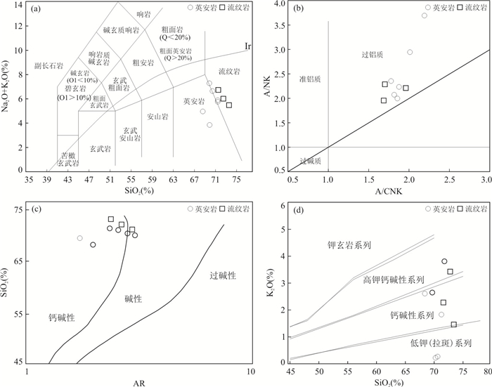
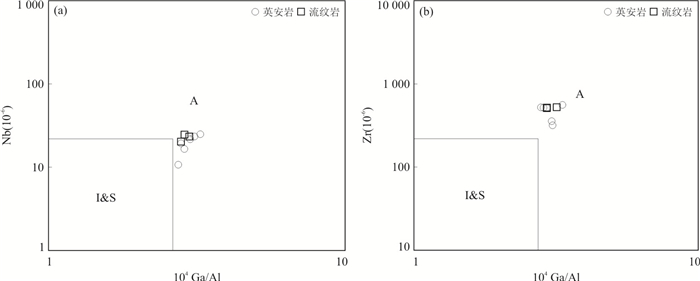
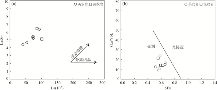
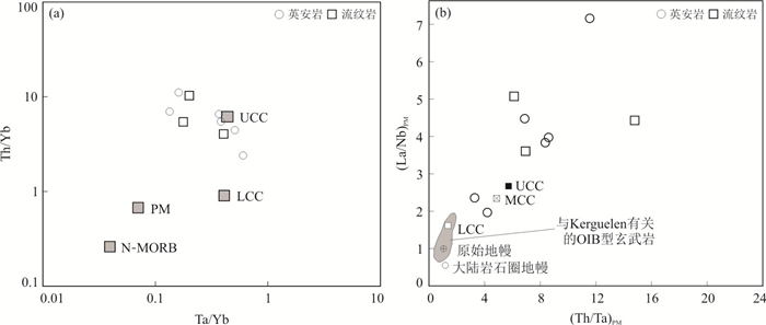
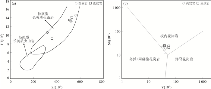
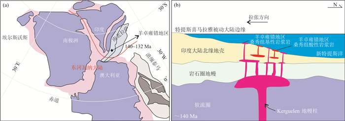
For a long time, there have been many controversies on whether the acid volcanic rocks of Sangxiu Formation in the central and eastern parts of the Tethyan-Himalaya tectonic belt were formed by crustal anatism and were related to the break-up of East Gondwana continent. In this study, the characteristics of acid volcanic rocks of Sangxiu Formation in YamzhoYumco area were studied. Based on the detailed field geological survey and sample collection, the petrography characteristics, LA-ICP-MS zircon U-Pb geochronology, whole-rock geochemistry and Hf isotope of zircon were investigated. The results show that weighted mean age of the two acid volcanic rock samples (RYA01 and DYA01) at the bottom of Sangxiu Formation in YamzhoYumco area were 139.1±1.3 Ma (1σ, MSWD=1.08) and 137.3±1.4 Ma (1σ, MSWD=0.98), respectively, indicating that the two acid volcanic rock samples were formed by the Early Cretaceous volcanic activity in the Tethyan-Himalaya region. The geochemical and Hf isotopic geochemical characteristics show that the acidic volcanic rocks have high content of SiO2, low magnesium index, high A/CNK ratio, enrichment of Al, LREE and Th, and strong depletion of Nb. The zircon εHf(t) values range from -20.1 to -10.5, with an average of -13.5. It is revealed that the acid volcanic rocks of Sangxiu Formation in YamzhoYumco area are magmatic products of partial melting of overlying crust induced by mantle derived magma underplating in the northern margin of Indian continent. Combining with the previous study, it is recognized that the genesis of the acid volcanic rocks is related to the rifting of East Gondwana continent. It is the early product of Kerguelen mantle plume.
For a long time, there have been many controversies on whether the acid volcanic rocks of Sangxiu Formation in the central and eastern parts of the Tethyan-Himalaya tectonic belt were formed by crustal anatism and were related to the break-up of East Gondwana continent. In this study, the characteristics of acid volcanic rocks of Sangxiu Formation in YamzhoYumco area were studied. Based on the detailed field geological survey and sample collection, the petrography characteristics, LA-ICP-MS zircon U-Pb geochronology, whole-rock geochemistry and Hf isotope of zircon were investigated. The results show that weighted mean age of the two acid volcanic rock samples (RYA01 and DYA01) at the bottom of Sangxiu Formation in YamzhoYumco area were 139.1±1.3 Ma (1σ, MSWD=1.08) and 137.3±1.4 Ma (1σ, MSWD=0.98), respectively, indicating that the two acid volcanic rock samples were formed by the Early Cretaceous volcanic activity in the Tethyan-Himalaya region. The geochemical and Hf isotopic geochemical characteristics show that the acidic volcanic rocks have high content of SiO2, low magnesium index, high A/CNK ratio, enrichment of Al, LREE and Th, and strong depletion of Nb. The zircon εHf(t) values range from -20.1 to -10.5, with an average of -13.5. It is revealed that the acid volcanic rocks of Sangxiu Formation in YamzhoYumco area are magmatic products of partial melting of overlying crust induced by mantle derived magma underplating in the northern margin of Indian continent. Combining with the previous study, it is recognized that the genesis of the acid volcanic rocks is related to the rifting of East Gondwana continent. It is the early product of Kerguelen mantle plume.


2021, 46(11): 3945-3964.
doi: 10.3799/dqkx.2020.378
Abstract:
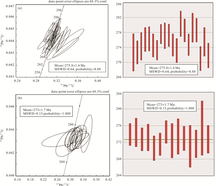
The marine Permian strata developed in the Beishan area, Gansu and Inner Mongolia, is one of the youngest marine sedimentary strata in the southern margin of the Central Asian orogenic belt. To further explore the timeline of the Permian paleo-Asian Ocean closure and the later collisional orogeny, five representative sections of the Permian marine volcaniclastic-clastic strata in the Houhongquan, Beishan, Gansu and Inner Mongolia were selected for lithology-petrography and distribution characteristics studies, and petrography, elemental geochemistry and whole-rock Sr-Nd isotope studies were conducted on the basalts in the marine strata. In addition, a typical rock profile was selected for LA-ICP-MS zircon U-Pb dating. The ages of the rhyodacite and the sand-bearing bright micrite bioclastic limestone are 273±1.7 Ma and 275.8±1.4 Ma, respectively. Combined with published age data and paleontological data, it is clear that the eruption age of the volcanic rock is between the Artinskian age of Early Permian to the Ward stage of the Middle Permian. It should be determined as the Shuangbaotang Formation. The SiO2 contents of basalt in Houhongquan area ranges from 47.48% to 54.56%, mainly basalt and basalt andesite, belonging to sodium-tholeiitic basalt. The total content of rare earth elements (ΣREE) is relatively high, ranging 74.90×10⁻⁶-173.61×10⁻⁶, LREE/HREE is between 2.32-6.55, showing slight enrichment of light rare earth elements relative to heavy rare earth elements, with (La/Yb)N=1.30-6.20. On the whole, chondrite-normalized distribution curve shows slightly enriched LREE with the gentle distribution curve, relatively enriched elements such as La, Ce, Nd, Zr, Hf, and depleted Ta, Nb, P, Ti and other elements to varying degrees, δEu=0.83-1.20, no obvious Eu anomaly. (87Sr/86Sr)i is 0.702 024-0.706 432, the εNd(t)values between 1.99 and 6.54 (except -0.59 and -0.83). Therefore, the basalt magma in the Houhongquan area is formed by low-degree melting of the garnet peridotite, which is close to the original mantle composition. During its evolution and diagenesis, it was not strongly contaminated by the crust, but a strong contaminant occurred in the magma source area. It is speculated that the asthenospheric mantle has been modified by terrigenous sedimentary rocks, continental crust or altered oceanic crust, and lithospheric delamination may be an important mechanism for its generation. It shows that the Paleo-Asian Ocean was closed in the early period, and the rift basin was formed by further extension and rifting in the Early-Middle Permian.
The marine Permian strata developed in the Beishan area, Gansu and Inner Mongolia, is one of the youngest marine sedimentary strata in the southern margin of the Central Asian orogenic belt. To further explore the timeline of the Permian paleo-Asian Ocean closure and the later collisional orogeny, five representative sections of the Permian marine volcaniclastic-clastic strata in the Houhongquan, Beishan, Gansu and Inner Mongolia were selected for lithology-petrography and distribution characteristics studies, and petrography, elemental geochemistry and whole-rock Sr-Nd isotope studies were conducted on the basalts in the marine strata. In addition, a typical rock profile was selected for LA-ICP-MS zircon U-Pb dating. The ages of the rhyodacite and the sand-bearing bright micrite bioclastic limestone are 273±1.7 Ma and 275.8±1.4 Ma, respectively. Combined with published age data and paleontological data, it is clear that the eruption age of the volcanic rock is between the Artinskian age of Early Permian to the Ward stage of the Middle Permian. It should be determined as the Shuangbaotang Formation. The SiO2 contents of basalt in Houhongquan area ranges from 47.48% to 54.56%, mainly basalt and basalt andesite, belonging to sodium-tholeiitic basalt. The total content of rare earth elements (ΣREE) is relatively high, ranging 74.90×10⁻⁶-173.61×10⁻⁶, LREE/HREE is between 2.32-6.55, showing slight enrichment of light rare earth elements relative to heavy rare earth elements, with (La/Yb)N=1.30-6.20. On the whole, chondrite-normalized distribution curve shows slightly enriched LREE with the gentle distribution curve, relatively enriched elements such as La, Ce, Nd, Zr, Hf, and depleted Ta, Nb, P, Ti and other elements to varying degrees, δEu=0.83-1.20, no obvious Eu anomaly. (87Sr/86Sr)i is 0.702 024-0.706 432, the εNd(t)values between 1.99 and 6.54 (except -0.59 and -0.83). Therefore, the basalt magma in the Houhongquan area is formed by low-degree melting of the garnet peridotite, which is close to the original mantle composition. During its evolution and diagenesis, it was not strongly contaminated by the crust, but a strong contaminant occurred in the magma source area. It is speculated that the asthenospheric mantle has been modified by terrigenous sedimentary rocks, continental crust or altered oceanic crust, and lithospheric delamination may be an important mechanism for its generation. It shows that the Paleo-Asian Ocean was closed in the early period, and the rift basin was formed by further extension and rifting in the Early-Middle Permian.


2021, 46(11): 3965-3992.
doi: 10.3799/dqkx.2021.035
Abstract:
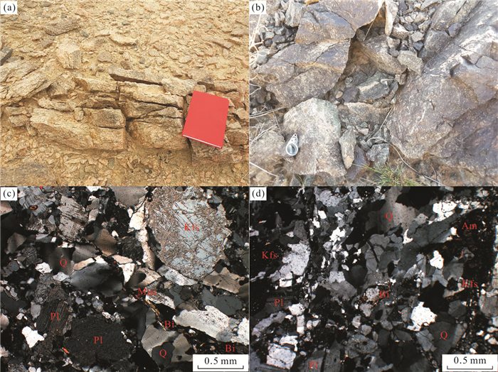
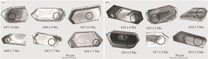
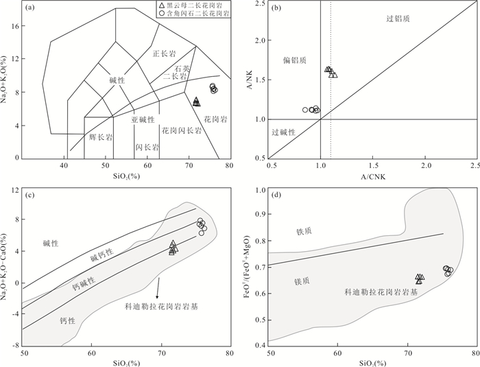
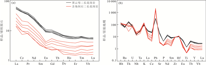
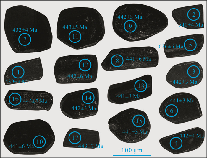
The Longxin and Xiaying plutons are located in the southwest of the Yangtze and Cathaysia blocks collision belt, studying the petrogenesis of the Ⅰ-type granitoids is of great geological significance to reveal the geodynamic background and tectonic evolution of the Early Paleozoic in Southeast Guangxi. LA-ICP-MS zircon U-Pb dating, geochemical and Lu-Hf isotopic data are reported for the host rock and its mafic microgranular enclave (MME) of Longxin and Xiaying plutons. Zircon U-Pb dating results of samples from the Longxin and Xiaying plutons show that the age of the host rock (granodiorite) of the Longxin pluton is 440±2 Ma, and that of the MME (diorite) of the Longxin pluton is 441±1 Ma, showing that the host rock and the MMEs are the products of the simultaneous magmatism. The age of the granodiorite and monzogranite of Xiaying pluton are 447±3 Ma and 436±3 Ma, indicating that there were at least two stages of intrusion in the Xiaying pluton. Both the host rocks (granodiorite) and MME (diorite) of the Longxin pluton have negative εHf(t) values (-3.32 to -5.83 and -17.89 to -1.82), and the corresponding two-stage model ages (TDM2) are 1.62-1.76 Ga and 1.57-2.54 Ga, respectively. The zircon εHf(t) values of the granodiorite (early stage) and monzogranite (late stage) of the Xiaying pluton are -15.43 to 3.03 and -4.79 to 6.82, respectively, with the TDM2 model ages of 1.59-1.99 Ga and 0.97-1.70 Ga, respectively, indicating that the parental magma of the granitic rocks might have originated mainly from crustal materials of the Paleoproterozoic-Mesoproterozoic. Geochemical data exhibit that the host rocks of the Longxin pluton are peraluminous high-K calc-alkaline Ⅰ-type granite, with relatively high light rare earth elements (LREE) and large ion lithophile elements (LILE), with low high field strength elements (HFSE) and heavy rare earth elements (HREE). For the Xiaying pluton, the granodiorite (early stage) is weakly peraluminous high-K calc-alkaline Ⅰ-type granite, while the monzogranite (late stage) is peraluminous high-K calc-alkaline Ⅰ-type granite, which is similar to the host rocks of the Longxin pluton. According to the petrography, geochronology, geochemistry and Hf isotopic composition characteristics of granites and mafic inclusions in the study area, indicating the MME (diorite) of Longxin formed by the magma mingling and mixing, although the host rock (granodiorite) of the Longxin and Xiaying plutons (granodiorite and monzogranite) have similar sources and petrogenesis, which have differences in magma mixing and fractional crystallization in the formation of granites. Based on previous studies on the tectonic setting in South China, it is suggested that the Longxin and Xiaying plutons were formed by the extension and thinning of the lithosphere, upwelling and underplating of the hot mantle-derived magma after the intra-continental orogeny of the Yangtze and Cathaysia blocks. The lower crust was partially melted under the influence of mantle heat and formed the acid magma, and then mixed with the mafic magma for limited and uneven degrees of crust-mantle mixing in the source region.
The Longxin and Xiaying plutons are located in the southwest of the Yangtze and Cathaysia blocks collision belt, studying the petrogenesis of the Ⅰ-type granitoids is of great geological significance to reveal the geodynamic background and tectonic evolution of the Early Paleozoic in Southeast Guangxi. LA-ICP-MS zircon U-Pb dating, geochemical and Lu-Hf isotopic data are reported for the host rock and its mafic microgranular enclave (MME) of Longxin and Xiaying plutons. Zircon U-Pb dating results of samples from the Longxin and Xiaying plutons show that the age of the host rock (granodiorite) of the Longxin pluton is 440±2 Ma, and that of the MME (diorite) of the Longxin pluton is 441±1 Ma, showing that the host rock and the MMEs are the products of the simultaneous magmatism. The age of the granodiorite and monzogranite of Xiaying pluton are 447±3 Ma and 436±3 Ma, indicating that there were at least two stages of intrusion in the Xiaying pluton. Both the host rocks (granodiorite) and MME (diorite) of the Longxin pluton have negative εHf(t) values (-3.32 to -5.83 and -17.89 to -1.82), and the corresponding two-stage model ages (TDM2) are 1.62-1.76 Ga and 1.57-2.54 Ga, respectively. The zircon εHf(t) values of the granodiorite (early stage) and monzogranite (late stage) of the Xiaying pluton are -15.43 to 3.03 and -4.79 to 6.82, respectively, with the TDM2 model ages of 1.59-1.99 Ga and 0.97-1.70 Ga, respectively, indicating that the parental magma of the granitic rocks might have originated mainly from crustal materials of the Paleoproterozoic-Mesoproterozoic. Geochemical data exhibit that the host rocks of the Longxin pluton are peraluminous high-K calc-alkaline Ⅰ-type granite, with relatively high light rare earth elements (LREE) and large ion lithophile elements (LILE), with low high field strength elements (HFSE) and heavy rare earth elements (HREE). For the Xiaying pluton, the granodiorite (early stage) is weakly peraluminous high-K calc-alkaline Ⅰ-type granite, while the monzogranite (late stage) is peraluminous high-K calc-alkaline Ⅰ-type granite, which is similar to the host rocks of the Longxin pluton. According to the petrography, geochronology, geochemistry and Hf isotopic composition characteristics of granites and mafic inclusions in the study area, indicating the MME (diorite) of Longxin formed by the magma mingling and mixing, although the host rock (granodiorite) of the Longxin and Xiaying plutons (granodiorite and monzogranite) have similar sources and petrogenesis, which have differences in magma mixing and fractional crystallization in the formation of granites. Based on previous studies on the tectonic setting in South China, it is suggested that the Longxin and Xiaying plutons were formed by the extension and thinning of the lithosphere, upwelling and underplating of the hot mantle-derived magma after the intra-continental orogeny of the Yangtze and Cathaysia blocks. The lower crust was partially melted under the influence of mantle heat and formed the acid magma, and then mixed with the mafic magma for limited and uneven degrees of crust-mantle mixing in the source region.


2021, 46(11): 3993-4005.
doi: 10.3799/dqkx.2020.367
Abstract:
The Mazongshan terrane is one of the main units of the Beishan orogenic collage. Among which there are abundant plutons, and they are of great significance for understanding and perfecting the Paleozoic tectonic framework of the Beishan orogenic collage. In this study, LA-ICP-MS zircon U-Pb dating yields the 206Pb/238U ages of 441±4 Ma and 425±2 Ma for the biotite monzogranite and hornblende monzogranite in Yemadaquan area respectively, which are the Early and Middle Silurian. The geochemical characteristics of the rocks show that they are sodium-rich, calc-alkalic, and magnesian. And their Ga/Al×104 and Zr+Nb+Ce+Y values are less than those of the A-type granite. Especially diagnostic mineral amphibole appears in hornblende monzogranite, meaning they belong to I-type granite. The εHf(t) values of their zircons are positive, and the crustal Hf model ages are concentrated at 0.94-1.42 Ga, suggesting that the Early-Middle Silurian granitic magmas may be derived from the partial melting of the Mesoproterozoic (~1.4 Ga) crust, with the participation of mantle-derived magmas. The analyses from geochemistry and regional data show that the granites were formed in the tectonic setting of continental arc, and the spatial and temporal distribution of Paleozoic granites suggests that slab roll-back might occur in the Early Carboniferous.
The Mazongshan terrane is one of the main units of the Beishan orogenic collage. Among which there are abundant plutons, and they are of great significance for understanding and perfecting the Paleozoic tectonic framework of the Beishan orogenic collage. In this study, LA-ICP-MS zircon U-Pb dating yields the 206Pb/238U ages of 441±4 Ma and 425±2 Ma for the biotite monzogranite and hornblende monzogranite in Yemadaquan area respectively, which are the Early and Middle Silurian. The geochemical characteristics of the rocks show that they are sodium-rich, calc-alkalic, and magnesian. And their Ga/Al×104 and Zr+Nb+Ce+Y values are less than those of the A-type granite. Especially diagnostic mineral amphibole appears in hornblende monzogranite, meaning they belong to I-type granite. The εHf(t) values of their zircons are positive, and the crustal Hf model ages are concentrated at 0.94-1.42 Ga, suggesting that the Early-Middle Silurian granitic magmas may be derived from the partial melting of the Mesoproterozoic (~1.4 Ga) crust, with the participation of mantle-derived magmas. The analyses from geochemistry and regional data show that the granites were formed in the tectonic setting of continental arc, and the spatial and temporal distribution of Paleozoic granites suggests that slab roll-back might occur in the Early Carboniferous.


2021, 46(11): 4006-4016.
doi: 10.3799/dqkx.2021.029
Abstract:
The Fangshan granite is located in the Yanshan tectonic belt of the North China craton, and is an asymmetric annular intrusive body. It is mainly composed of multi-stage intrusive granodiorites which are divided into three lithofacies belts including central facies, transitional facies and marginal facies. In addition, there are a lot of mafic microgranular enclaves (MMEs) distributed within the pluton. Biotite is one of the main minerals in intermediate acid igneous rocks, and its mineral geochemical characteristics record the properties of host magma and the physical and chemical conditions of petrogenesis. In this study, the biotite in the granite and MMEs was systematically observed. The chemical composition of biotite was studied in detail by electron probe microanalysis (EPMA). Finally, the magma source and mixing process of the Fangshan granite are discussed. The results show that the biotite in the granite and the MMEs have similar chemical compositions. The biotite in the granite is rich in Mg and poor in Fe, which belongs to magnesian biotite. The iron content coefficients[(Fe3++Fe2+)/(Fe3++Fe2++Mg2+)] of granite in three facies zones from the outside to the inside are 0.42-0.47, 0.45-0.47 and 0.41-0.46, respectively. The FeOT/MgO ratio is close to 0.60. The MF values[2×Mg/(Fe2++Mg+Mn)] are 1.05-1.21, 1.06-1.15 and 1.12-1.23, indicating the source material were derived from crust-mantle mixed rocks. The biotite's MF values of MMEs in three lithofacies belts from the outside to the inside are 1.00-1.16, 1.03-1.15 and 1.10-1.18. The biotite is magnesia biotite, suggesting that primitive magma was influenced by intermediate-acid magma. The above results show that biotite from both the granite and MMEs has similar chemical characteristics. However, there are some differences among different lithofacies. Therefore, it speculates that magma mixing has occurred in the Fangshan granite. The magma mixing is a multi-stage interaction process and may be caused by the mantle-derived magma which is injected into the crustal-derived acid magma during multiple stages.
The Fangshan granite is located in the Yanshan tectonic belt of the North China craton, and is an asymmetric annular intrusive body. It is mainly composed of multi-stage intrusive granodiorites which are divided into three lithofacies belts including central facies, transitional facies and marginal facies. In addition, there are a lot of mafic microgranular enclaves (MMEs) distributed within the pluton. Biotite is one of the main minerals in intermediate acid igneous rocks, and its mineral geochemical characteristics record the properties of host magma and the physical and chemical conditions of petrogenesis. In this study, the biotite in the granite and MMEs was systematically observed. The chemical composition of biotite was studied in detail by electron probe microanalysis (EPMA). Finally, the magma source and mixing process of the Fangshan granite are discussed. The results show that the biotite in the granite and the MMEs have similar chemical compositions. The biotite in the granite is rich in Mg and poor in Fe, which belongs to magnesian biotite. The iron content coefficients[(Fe3++Fe2+)/(Fe3++Fe2++Mg2+)] of granite in three facies zones from the outside to the inside are 0.42-0.47, 0.45-0.47 and 0.41-0.46, respectively. The FeOT/MgO ratio is close to 0.60. The MF values[2×Mg/(Fe2++Mg+Mn)] are 1.05-1.21, 1.06-1.15 and 1.12-1.23, indicating the source material were derived from crust-mantle mixed rocks. The biotite's MF values of MMEs in three lithofacies belts from the outside to the inside are 1.00-1.16, 1.03-1.15 and 1.10-1.18. The biotite is magnesia biotite, suggesting that primitive magma was influenced by intermediate-acid magma. The above results show that biotite from both the granite and MMEs has similar chemical characteristics. However, there are some differences among different lithofacies. Therefore, it speculates that magma mixing has occurred in the Fangshan granite. The magma mixing is a multi-stage interaction process and may be caused by the mantle-derived magma which is injected into the crustal-derived acid magma during multiple stages.


2021, 46(11): 4017-4032.
doi: 10.3799/dqkx.2020.353
Abstract:
Based on the field geological investigation, microstructural observation and magnetic fabric of tectonites, it recognized a large ductile shear zone in Sanmen area of North Guangxi, also defined the deformation age of Sanmen ductile shear zone by hydrothermal zircon U-Pb dating. The ductile shear zone has typical macroscopic and microstructural characteristics of mylonite series, such as penetrating schistosity, rotational porphyroclast systems, stretching lineation, eyeball structures, domino structures, A-type fold, wavy extinction, deformation twins, core and mantle textures and S-C fabric. Anisotropy of magnetic susceptibility (P values) shows Sanmen ductile shear zone trending in NNE and inclination of NWW. Kinematics orientation research shows that the Sanmen ductile shear zone has left-lateral thrust shear in the early stage and right-lateral normal slip shear in the late stage, magnetic susceptibility ellipsoid (E values) indicates that the rock deformation in Sanmen ductile shear zone is mainly flattened strain, suggesting that its kinematic direction is mainly left-lateral thrust shear. The hydrothermal zircon U-Pb dating result of mafic mylonite is 441±2 Ma, which represents the deformation age of Sanmen ductile shear zone. Based on the study of magnetic fabric, kinematics and tectonic chronology of Sanmen ductile shear zone, combined with regional geological data, it is considered that Sanmen ductile shear zone is the product of the recoil of the Caledonian Cathaysian block in South China from SE to NW to the Yangtze block. The discovery of the Sanmen ductile shear zone reveals the way and age of collision of Yangtze and Cathaysian blocks, and deepens the understanding of Caledonian tectonic evolution of the South China.
Based on the field geological investigation, microstructural observation and magnetic fabric of tectonites, it recognized a large ductile shear zone in Sanmen area of North Guangxi, also defined the deformation age of Sanmen ductile shear zone by hydrothermal zircon U-Pb dating. The ductile shear zone has typical macroscopic and microstructural characteristics of mylonite series, such as penetrating schistosity, rotational porphyroclast systems, stretching lineation, eyeball structures, domino structures, A-type fold, wavy extinction, deformation twins, core and mantle textures and S-C fabric. Anisotropy of magnetic susceptibility (P values) shows Sanmen ductile shear zone trending in NNE and inclination of NWW. Kinematics orientation research shows that the Sanmen ductile shear zone has left-lateral thrust shear in the early stage and right-lateral normal slip shear in the late stage, magnetic susceptibility ellipsoid (E values) indicates that the rock deformation in Sanmen ductile shear zone is mainly flattened strain, suggesting that its kinematic direction is mainly left-lateral thrust shear. The hydrothermal zircon U-Pb dating result of mafic mylonite is 441±2 Ma, which represents the deformation age of Sanmen ductile shear zone. Based on the study of magnetic fabric, kinematics and tectonic chronology of Sanmen ductile shear zone, combined with regional geological data, it is considered that Sanmen ductile shear zone is the product of the recoil of the Caledonian Cathaysian block in South China from SE to NW to the Yangtze block. The discovery of the Sanmen ductile shear zone reveals the way and age of collision of Yangtze and Cathaysian blocks, and deepens the understanding of Caledonian tectonic evolution of the South China.


2021, 46(11): 4033-4042.
doi: 10.3799/dqkx.2019.960
Abstract:
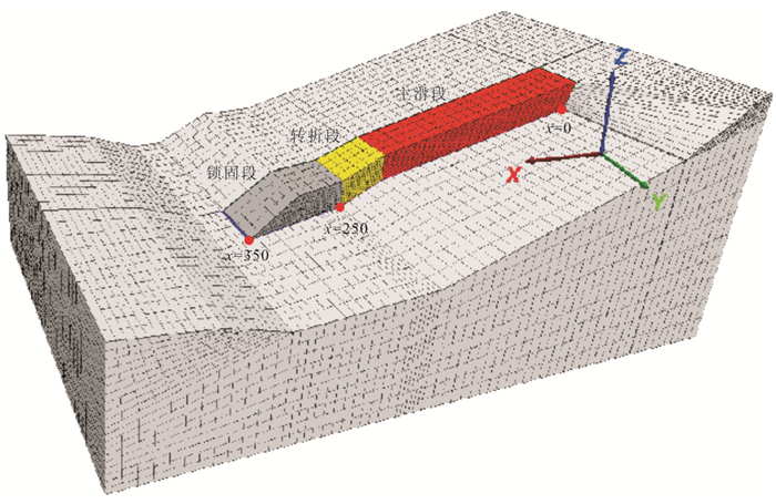
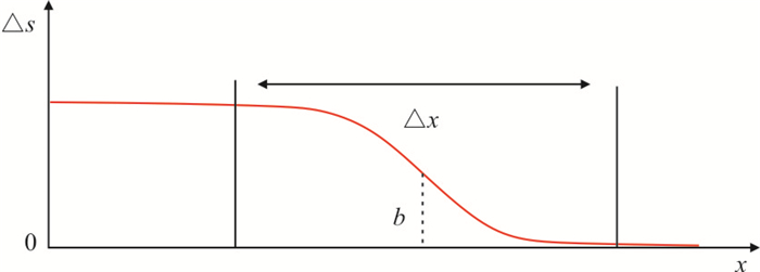
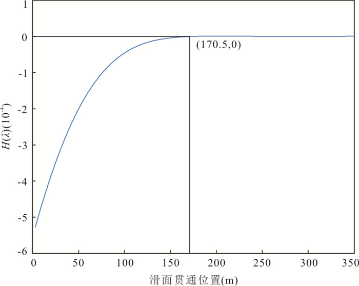
Bedding rockslide is the most common slope disaster. It is of great significance to study its progressive failure process and establish prediction criteria for disaster prevention and mitigation. Taking Shanshucao landslide in Zigui as an example, on the basis of field investigation and indoor rock test, the basic mechanical parameters of landslide were estimated by JRC-JCS model and GSI method. The progressive failure process of landslide was simulated by FLAC3D, and the development law of deformation and failure of bedding rockslide was analyzed. Based on the principle of energy conservation and virtual work, the energetic criterion for accelerated deformation of bedding rockslide is proposed. The results show that the landslide mass of Shanshucao is progressively destroyed from the rear edge to the front, the accumulated total displacement value of the trailing edge deformation increases continuously, the locking effect of the front cutting layer makes the deformation decrease rapidly. When approaching failure, displacement of the leading edge develops from front to back, transfixion of sliding face occurs quickly. The strain curve along the sliding direction of the landslide can be approximated as a "S" curve, which develops downhill with progressive failure. Taking the kinetic energy increment of the landslide mass greater than 0 as the energetic criterion for accelerated deformation of the landslide, the results are consistent with the geological evolution of landslides and are in good agreement with those of FLAC3D simulation.
Bedding rockslide is the most common slope disaster. It is of great significance to study its progressive failure process and establish prediction criteria for disaster prevention and mitigation. Taking Shanshucao landslide in Zigui as an example, on the basis of field investigation and indoor rock test, the basic mechanical parameters of landslide were estimated by JRC-JCS model and GSI method. The progressive failure process of landslide was simulated by FLAC3D, and the development law of deformation and failure of bedding rockslide was analyzed. Based on the principle of energy conservation and virtual work, the energetic criterion for accelerated deformation of bedding rockslide is proposed. The results show that the landslide mass of Shanshucao is progressively destroyed from the rear edge to the front, the accumulated total displacement value of the trailing edge deformation increases continuously, the locking effect of the front cutting layer makes the deformation decrease rapidly. When approaching failure, displacement of the leading edge develops from front to back, transfixion of sliding face occurs quickly. The strain curve along the sliding direction of the landslide can be approximated as a "S" curve, which develops downhill with progressive failure. Taking the kinetic energy increment of the landslide mass greater than 0 as the energetic criterion for accelerated deformation of the landslide, the results are consistent with the geological evolution of landslides and are in good agreement with those of FLAC3D simulation.


2021, 46(11): 4043-4056.
doi: 10.3799/dqkx.2021.121
Abstract:
Structural transfer zone has been widely concerned by scholars for its important petroleum geological significance, especially the control of the transfer slope on the distribution direction and accumulation range of large sand bodies. In view of the complexity of the distribution of sand bodies and high-quality reservoirs in the transfer zone and nearby steep slope zone, taking the southwest edge of Huizhou depression as an example, a prediction method of high-quality sand bodies in the transfer zone based on the concept of "transfer model" is proposed. Compared with the transfer zone, the study of transfer model is an extension and deepening of the transfer zone studies. In the research scope, the transfer slope zone and fault controlled steep slope are regarded as the combination, emphasizing that there is dynamic space-time interaction between the two sedimentary bodies under the three-dimensional combination. In the research content, the genesis and evolution of high-quality sand bodies are analyzed with the idea of "structure-landform-sedimentation-reservoir", so as to have stronger petroleum geological significance. Based on the concept of "transfer model", in this paper it proposes that three types of transfer models of "acute angle-right angle-obtuse angle" can be divided in the southwest of Huizhou 26 sag. In the structure-geomorphic framework of different types of transfer models, there are three types of sedimentation control effects between the steep slope and the transfer slope fan, which are isolation-superimposition-joint control, and their reservoir physical properties gradually become better. Systematic analysis of sedimentary-reservoir characteristics of transfer model in the Huizhou depression is of theoretical significance to improve the transformation system framework, and it can also meet the exploration demands of large and medium-sized oil and gas reservoirs.
Structural transfer zone has been widely concerned by scholars for its important petroleum geological significance, especially the control of the transfer slope on the distribution direction and accumulation range of large sand bodies. In view of the complexity of the distribution of sand bodies and high-quality reservoirs in the transfer zone and nearby steep slope zone, taking the southwest edge of Huizhou depression as an example, a prediction method of high-quality sand bodies in the transfer zone based on the concept of "transfer model" is proposed. Compared with the transfer zone, the study of transfer model is an extension and deepening of the transfer zone studies. In the research scope, the transfer slope zone and fault controlled steep slope are regarded as the combination, emphasizing that there is dynamic space-time interaction between the two sedimentary bodies under the three-dimensional combination. In the research content, the genesis and evolution of high-quality sand bodies are analyzed with the idea of "structure-landform-sedimentation-reservoir", so as to have stronger petroleum geological significance. Based on the concept of "transfer model", in this paper it proposes that three types of transfer models of "acute angle-right angle-obtuse angle" can be divided in the southwest of Huizhou 26 sag. In the structure-geomorphic framework of different types of transfer models, there are three types of sedimentation control effects between the steep slope and the transfer slope fan, which are isolation-superimposition-joint control, and their reservoir physical properties gradually become better. Systematic analysis of sedimentary-reservoir characteristics of transfer model in the Huizhou depression is of theoretical significance to improve the transformation system framework, and it can also meet the exploration demands of large and medium-sized oil and gas reservoirs.


2021, 46(11): 4057-4071.
doi: 10.3799/dqkx.2021.032
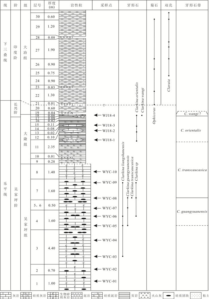
Abstract:
The Dalong Formation is an important deep-water deposition during late Lopingian in South China. For better understanding of the spatial and temporal distribution of the Dalong Formation, detailed conodont biostratigraphic research is conducted from the Wujiaping Formation and Dalong Formation, at the Wujiachong section, East Hubei, South China. As a result, five species of genus Clarkina are recognized. Four conodont zones are established, and they are C. guangyuanensis, C. transcaucasica, C. orientalis and C. wangi zones, in ascending order. The Wuchiapingian-Changhsingian boundary (WCB) is placed at the base of bed 18 of the Wujiachong section based on the first occurrence of conodont C. wangi. The Permian-Triassic boundary (PTB) is placed at the top of bed 20 according to the first occurrence of ammonoid Ophiceras, only 0.72 m higher than WCB. Conodont biozones correlation suggests that the Dalong Formation of the Wujiachong section is mainly in age of Wuchiapingian. The absence of the several Changhsingian conodont zones and shorten Changhsingian deposition suggest that the middle and upper parts of Changhsingian of this section may be absent due to a hiatus.
The Dalong Formation is an important deep-water deposition during late Lopingian in South China. For better understanding of the spatial and temporal distribution of the Dalong Formation, detailed conodont biostratigraphic research is conducted from the Wujiaping Formation and Dalong Formation, at the Wujiachong section, East Hubei, South China. As a result, five species of genus Clarkina are recognized. Four conodont zones are established, and they are C. guangyuanensis, C. transcaucasica, C. orientalis and C. wangi zones, in ascending order. The Wuchiapingian-Changhsingian boundary (WCB) is placed at the base of bed 18 of the Wujiachong section based on the first occurrence of conodont C. wangi. The Permian-Triassic boundary (PTB) is placed at the top of bed 20 according to the first occurrence of ammonoid Ophiceras, only 0.72 m higher than WCB. Conodont biozones correlation suggests that the Dalong Formation of the Wujiachong section is mainly in age of Wuchiapingian. The absence of the several Changhsingian conodont zones and shorten Changhsingian deposition suggest that the middle and upper parts of Changhsingian of this section may be absent due to a hiatus.


2021, 46(11): 4072-4083.
doi: 10.3799/dqkx.2021.006
Abstract:
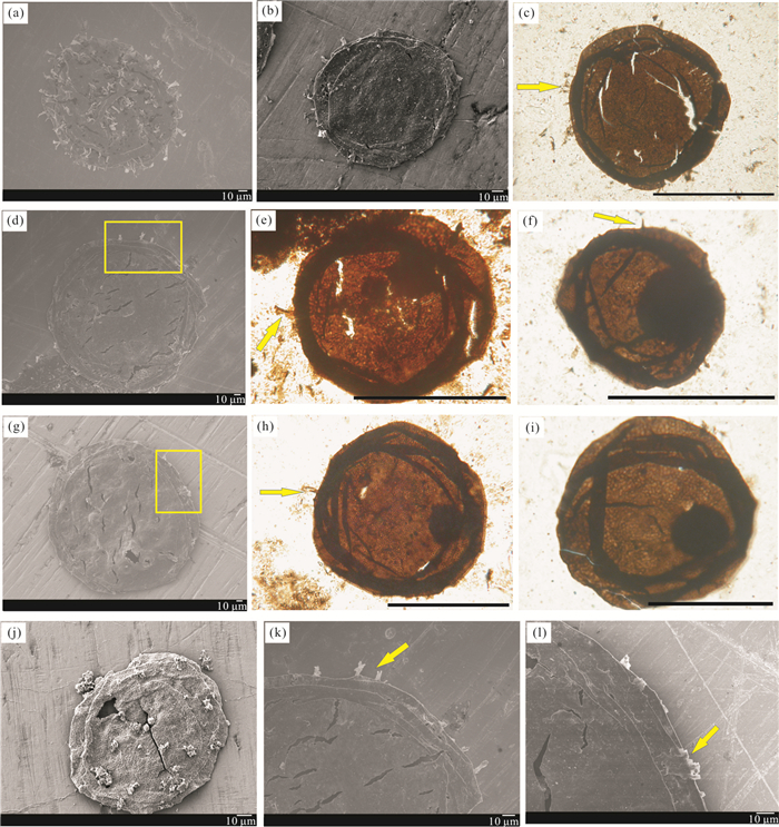
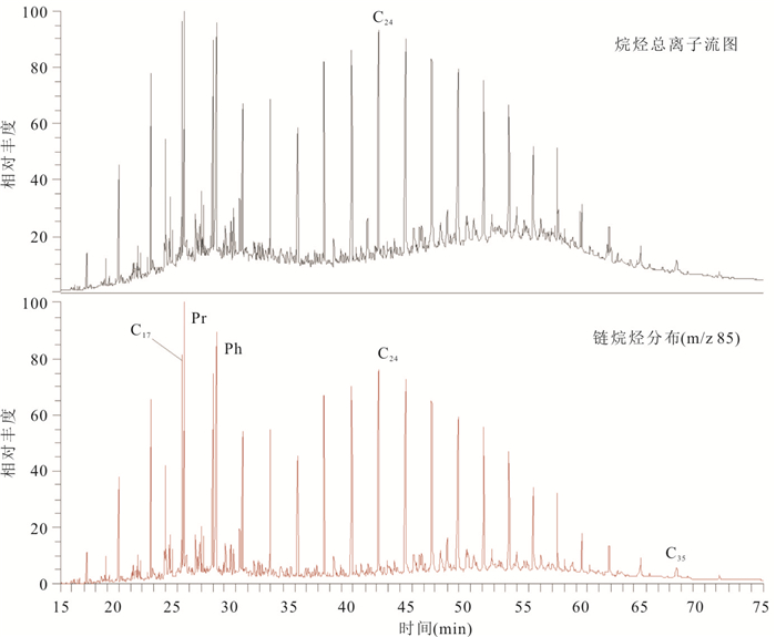
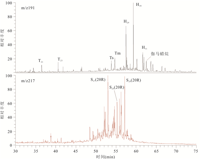
There are a large number of acritarchs with spines and fine reticular patterns, well exposed in the shale of Baicaoping Formation of Ruyang Group in western Henan, such as Shuiyousphaeridium macroreticulatum and Dictyosphaera macroreticulata which are the most representative fossil specimens. In this paper, the microscopic structure of the membrane shell was observed by scanning electron microscope combined with optical biological microscope. Moreover, the two representative fossil specimens (Shuiyousphaeridium macroreticulatum and Dictyosphaera macroreticulata) may be produced at different stages of the same organism. These features not only reveal more information about the original characteristics of the microbe, but also enrich the morphological classification of the microfossils in Ruyang Group. In addition, based on the analyses of biomarker from shale with microfossils, it shows that pristane/phytane ratio (Pr/Ph) is greater than 1, the abundance of gammacerane is medium and there is biomarker (C30 hopane, C27 sterane and tricyclic terpane), which not only indicates that the paleoenvironment of microfossils in Ruyang Group should be normal marine environment-coastal-shallow sea facies, but also indicates the existence of Proterozoic eukaryotes, which provides an important theoretical basis for the reconstruction of microfauna and the discussion of the evolution of early life.
There are a large number of acritarchs with spines and fine reticular patterns, well exposed in the shale of Baicaoping Formation of Ruyang Group in western Henan, such as Shuiyousphaeridium macroreticulatum and Dictyosphaera macroreticulata which are the most representative fossil specimens. In this paper, the microscopic structure of the membrane shell was observed by scanning electron microscope combined with optical biological microscope. Moreover, the two representative fossil specimens (Shuiyousphaeridium macroreticulatum and Dictyosphaera macroreticulata) may be produced at different stages of the same organism. These features not only reveal more information about the original characteristics of the microbe, but also enrich the morphological classification of the microfossils in Ruyang Group. In addition, based on the analyses of biomarker from shale with microfossils, it shows that pristane/phytane ratio (Pr/Ph) is greater than 1, the abundance of gammacerane is medium and there is biomarker (C30 hopane, C27 sterane and tricyclic terpane), which not only indicates that the paleoenvironment of microfossils in Ruyang Group should be normal marine environment-coastal-shallow sea facies, but also indicates the existence of Proterozoic eukaryotes, which provides an important theoretical basis for the reconstruction of microfauna and the discussion of the evolution of early life.


2021, 46(11): 4084-4096.
doi: 10.3799/dqkx.2021.024
Abstract:
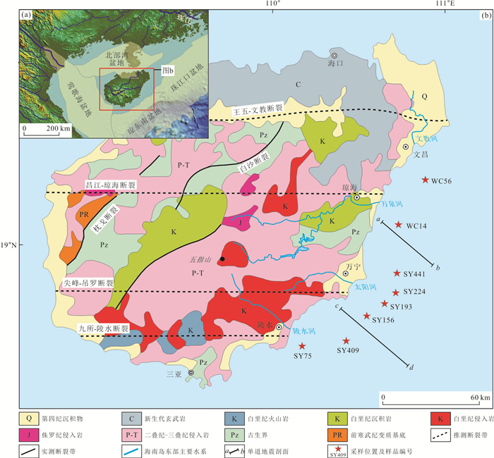
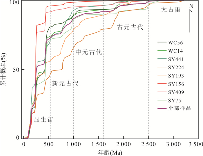
In order to explore the provenance of surface sediments in the southeastern sea of Hainan Island and reveal the evolution history of major geological tectonic events in the provenance area, it used the box corer method to obtain sediment samples from 8 stations, and zircon U-Pb dating analyses were performed. The results show that 773 effective ages are distributed between 33 and 3 205 Ma, and the main age peaks are concentrated in the Yanshanian (100 Ma, 140 Ma and 159 Ma), Indosinian (242 Ma) and Caledonian (439 Ma). The secondary age peaks are concentrated in the Neoproterozoic (776 Ma, 965 Ma) and Paleoproterozoic (1 836 Ma, 2 487 Ma), and the Archean basement age information is scattered. A small number of metamorphic zircons records strong metamorphic events in the Caledonian and Indosinian. A comparative analysis with potential provenance area shows that the sediments in the southeastern sea of Hainan Island are identified by the age peak of about 100 Ma, which are mainly from Hainan Island. Combined with previous studies, the age spectrum in this study indicates that the Caledonian Wuyi-Yunkai orogenic belt in Cathaysia can extend to Hainan Island, the closure of the Paleo-Tethys Ocean and the collision between the Indosinian and Cathaysia blocks in Hercynian-Indosinian led to its strong tectonism-magmatism-metamorphism, and Hainan Island developed multiple magmatic activities due to the subduction of the Pacific plate in the Yanshanian.
In order to explore the provenance of surface sediments in the southeastern sea of Hainan Island and reveal the evolution history of major geological tectonic events in the provenance area, it used the box corer method to obtain sediment samples from 8 stations, and zircon U-Pb dating analyses were performed. The results show that 773 effective ages are distributed between 33 and 3 205 Ma, and the main age peaks are concentrated in the Yanshanian (100 Ma, 140 Ma and 159 Ma), Indosinian (242 Ma) and Caledonian (439 Ma). The secondary age peaks are concentrated in the Neoproterozoic (776 Ma, 965 Ma) and Paleoproterozoic (1 836 Ma, 2 487 Ma), and the Archean basement age information is scattered. A small number of metamorphic zircons records strong metamorphic events in the Caledonian and Indosinian. A comparative analysis with potential provenance area shows that the sediments in the southeastern sea of Hainan Island are identified by the age peak of about 100 Ma, which are mainly from Hainan Island. Combined with previous studies, the age spectrum in this study indicates that the Caledonian Wuyi-Yunkai orogenic belt in Cathaysia can extend to Hainan Island, the closure of the Paleo-Tethys Ocean and the collision between the Indosinian and Cathaysia blocks in Hercynian-Indosinian led to its strong tectonism-magmatism-metamorphism, and Hainan Island developed multiple magmatic activities due to the subduction of the Pacific plate in the Yanshanian.


2021, 46(11): 4097-4106.
doi: 10.3799/dqkx.2020.374
Abstract:
Zinc isotope represents new tracers of oceanography, which is used to trace the source and migration of zinc in seawater. As important sources and/or sinks of zinc, the study of zinc isotopic composition of marine sediments is of great significance to our understanding of geochemical cycling of zinc. In addition, marine sediments record the composition of seawater, and the study of zinc isotope fractionation between marine sediments and seawater is a prerequisite for tracing zinc isotopic composition of ancient seawater. In this paper, researches on zinc isotopes of seawater and reservoirs in the ocean are systematically summarized, including zinc isotope study of riverine inputs, hydrothermal systems and different types of marine sediments (carbonate-rich sediments, terrigenous silicate fragments, siliceous sediments, ferromanganese nodules and suboxic/anoxic sediments), to explain the applications and importance of zinc isotope variations of marine sediments in paleoclimate, paleoenvironment and paleoceanography.
Zinc isotope represents new tracers of oceanography, which is used to trace the source and migration of zinc in seawater. As important sources and/or sinks of zinc, the study of zinc isotopic composition of marine sediments is of great significance to our understanding of geochemical cycling of zinc. In addition, marine sediments record the composition of seawater, and the study of zinc isotope fractionation between marine sediments and seawater is a prerequisite for tracing zinc isotopic composition of ancient seawater. In this paper, researches on zinc isotopes of seawater and reservoirs in the ocean are systematically summarized, including zinc isotope study of riverine inputs, hydrothermal systems and different types of marine sediments (carbonate-rich sediments, terrigenous silicate fragments, siliceous sediments, ferromanganese nodules and suboxic/anoxic sediments), to explain the applications and importance of zinc isotope variations of marine sediments in paleoclimate, paleoenvironment and paleoceanography.


2021, 46(11): 4107-4117.
doi: 10.3799/dqkx.2020.368
Abstract:
Sansha Bay in East Fujian is the most typical closed bay where many rivers flows into. It is the largest cage breeding base for Pseudosciaena crocea in the world and one of most important fishery breeding bases in China. However, several surveys have found that the algae production in this bay is far low compared to other bays, which presents the unique ecological characteristics of "more nutrients and less algae", but the mechanism has not been discussed in-depth. Using fixed-stations and large-scale navigation methods, in this study it investigated the tidal movement and spatial distribution of five nutrients (active silicate (SiO3-Si), nitrate nitrogen (NO3-N), nitrite nitrogen (NO2-N), ammonia nitrogen (NH4-N) and active phosphate (PO4-P)) in 2018-2020. The results show follows. (1)The upstream input causes the ebb concentration of SiO3-Si and NO3-N to be greater than the rise concentration, and they decrease linearly from the shore to the bay with salinity. (2) The aquaculture in the bay and the output of the natural ecosystem cause the rise concentrations of NO2-N, NH4-N, and PO4-P to be greater than the ebb concentrations, and the concentration in flood season is greater than that in the dry season. NO2-N increases nonlinearity with salinity from the shore to the bay instead of it is an abnormal phenomenon that NH4-N and PO4-P are evenly distributed along with the increase of salinity. However, the fall concentrations of NH4-N and PO4-P near the coastal sewage outlet are greater than the rise concentration. (3) The high concentrations of NH4-N and PO4-P imported from sewage discharge in the bay and coastal areas are the main cause of serious water pollution. Eutrophication in the Sansha Bay is the main factor of the unique ecological characteristics of "more nutrients and less algae".
Sansha Bay in East Fujian is the most typical closed bay where many rivers flows into. It is the largest cage breeding base for Pseudosciaena crocea in the world and one of most important fishery breeding bases in China. However, several surveys have found that the algae production in this bay is far low compared to other bays, which presents the unique ecological characteristics of "more nutrients and less algae", but the mechanism has not been discussed in-depth. Using fixed-stations and large-scale navigation methods, in this study it investigated the tidal movement and spatial distribution of five nutrients (active silicate (SiO3-Si), nitrate nitrogen (NO3-N), nitrite nitrogen (NO2-N), ammonia nitrogen (NH4-N) and active phosphate (PO4-P)) in 2018-2020. The results show follows. (1)The upstream input causes the ebb concentration of SiO3-Si and NO3-N to be greater than the rise concentration, and they decrease linearly from the shore to the bay with salinity. (2) The aquaculture in the bay and the output of the natural ecosystem cause the rise concentrations of NO2-N, NH4-N, and PO4-P to be greater than the ebb concentrations, and the concentration in flood season is greater than that in the dry season. NO2-N increases nonlinearity with salinity from the shore to the bay instead of it is an abnormal phenomenon that NH4-N and PO4-P are evenly distributed along with the increase of salinity. However, the fall concentrations of NH4-N and PO4-P near the coastal sewage outlet are greater than the rise concentration. (3) The high concentrations of NH4-N and PO4-P imported from sewage discharge in the bay and coastal areas are the main cause of serious water pollution. Eutrophication in the Sansha Bay is the main factor of the unique ecological characteristics of "more nutrients and less algae".


2021, 46(11): 4118-4126.
doi: 10.3799/dqkx.2020.377
Abstract:
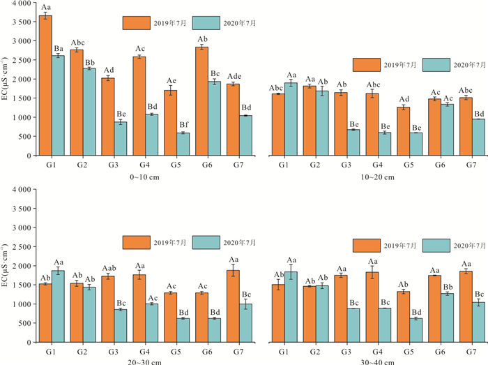
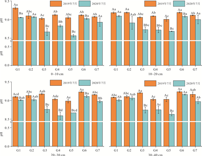
The use of gravel barrier to block capillary action provides a new idea for soil salinization improvement. In order to demonstrate the feasibility of soil salinization improvement using gravel, a test site was established in the typical salinization distribution area of Hangjin Rear Banner in the west of Hetao irrigation area. Different structures and buried depths of gravel layers were explored to identify the improvement effect of soil salinization. Soil salinity, pH, cation exchange capacity (CEC) and the percentage of sodium exchange were monitored for one year. The results show that among the 7 groups of different treatments, the treatment with buried depth of 60-80 cm and particle diameter of 1 cm and 3 cm was the best condition. The average soil EC value of at the four depths from the surface to 40 cm decreased by 55.9%. The gravel barrier buried deeply and laid down in a fine-grained and coarse manner, which have higher porosity in the bottom layer of the gravel barrier, can cut off the capillary at the deeper depth of unsaturated zone. Therefore, it can decrease effectively the rising height of soil capillary, and inhibit the salt in the deep soils from upward, namely "salt return".
The use of gravel barrier to block capillary action provides a new idea for soil salinization improvement. In order to demonstrate the feasibility of soil salinization improvement using gravel, a test site was established in the typical salinization distribution area of Hangjin Rear Banner in the west of Hetao irrigation area. Different structures and buried depths of gravel layers were explored to identify the improvement effect of soil salinization. Soil salinity, pH, cation exchange capacity (CEC) and the percentage of sodium exchange were monitored for one year. The results show that among the 7 groups of different treatments, the treatment with buried depth of 60-80 cm and particle diameter of 1 cm and 3 cm was the best condition. The average soil EC value of at the four depths from the surface to 40 cm decreased by 55.9%. The gravel barrier buried deeply and laid down in a fine-grained and coarse manner, which have higher porosity in the bottom layer of the gravel barrier, can cut off the capillary at the deeper depth of unsaturated zone. Therefore, it can decrease effectively the rising height of soil capillary, and inhibit the salt in the deep soils from upward, namely "salt return".


2021, 46(11): 4127-4139.
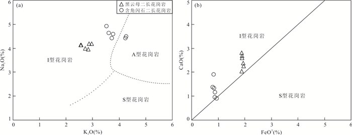
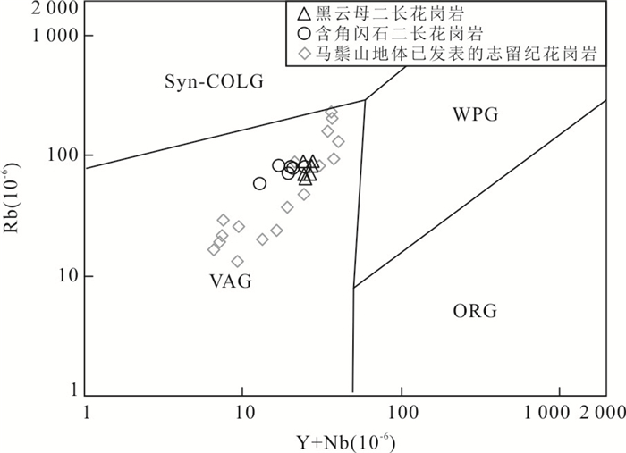
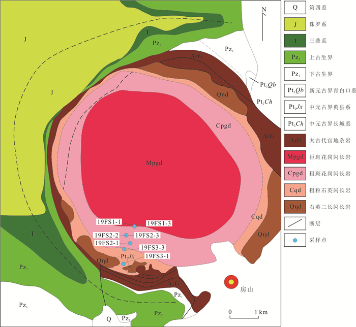
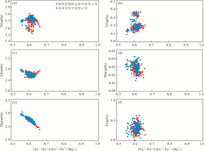
doi: 10.3799/dqkx.2021.019
Abstract:
The Shuikoushan area in Hunan Province is one of the seriously heavy metal pollution areas in Hunan Province. The Longwangshan gold deposit is an important gold deposit in this area. To investigate the pollution source characteristics, pollution pathways, heavy metal mobility, and potential hazards of the waste rock pile of this deposit, a 24 m shallow drilling system was conducted to evaluate the waste rock pile of FS17, and the acidic wastewater from the waste rock pile was collected to analyze the total amount of heavy metals. The single factor index and Nemerow comprehensive pollution index suggest that the FS17 contains large amounts of heavy metals (Cd, Cu, Pb, As, Zn, Ni, and Cr) with an unevenly vertical distribution; the natural leaching water samples have high heavy metal contents. The migration index implies that the FS17 has heavy metal potential migration order of Cd > Ni≈ Zn > Cu > Pb > As > Cr > Fe in shallow layer, and of Cd > Zn > Cu > Ni > Cr > Pb > As > Fe in deep layer. The mobility of heavy metal elements in the shallow layer is greater than that in the deep layer. Thus, in this paper it argues that the FS17 is the main pollution source of heavy metals in this area, and acidic wastewater is the main way to release pollution elements. The heavy metals of Cd, Cu, Zn, and Ni have stronger mobility and are main polluting elements for the surrounding environment. The mobility of Pb, Ni, As is significantly reduced in the deep layer, and its mobility can be weakened by deep burying, and Cr will not pollute the surrounding environment.
The Shuikoushan area in Hunan Province is one of the seriously heavy metal pollution areas in Hunan Province. The Longwangshan gold deposit is an important gold deposit in this area. To investigate the pollution source characteristics, pollution pathways, heavy metal mobility, and potential hazards of the waste rock pile of this deposit, a 24 m shallow drilling system was conducted to evaluate the waste rock pile of FS17, and the acidic wastewater from the waste rock pile was collected to analyze the total amount of heavy metals. The single factor index and Nemerow comprehensive pollution index suggest that the FS17 contains large amounts of heavy metals (Cd, Cu, Pb, As, Zn, Ni, and Cr) with an unevenly vertical distribution; the natural leaching water samples have high heavy metal contents. The migration index implies that the FS17 has heavy metal potential migration order of Cd > Ni≈ Zn > Cu > Pb > As > Cr > Fe in shallow layer, and of Cd > Zn > Cu > Ni > Cr > Pb > As > Fe in deep layer. The mobility of heavy metal elements in the shallow layer is greater than that in the deep layer. Thus, in this paper it argues that the FS17 is the main pollution source of heavy metals in this area, and acidic wastewater is the main way to release pollution elements. The heavy metals of Cd, Cu, Zn, and Ni have stronger mobility and are main polluting elements for the surrounding environment. The mobility of Pb, Ni, As is significantly reduced in the deep layer, and its mobility can be weakened by deep burying, and Cr will not pollute the surrounding environment.

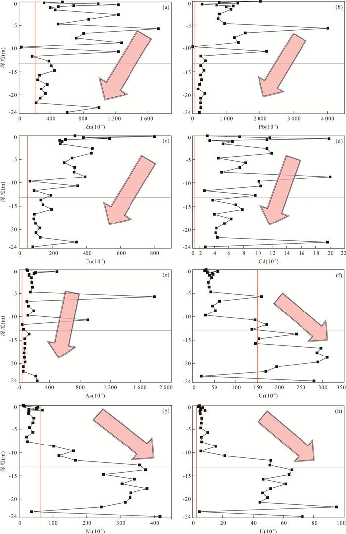

2021, 46(11): 4140-4149.
doi: 10.3799/dqkx.2020.398
Abstract:
Long-term uptake of high iodine groundwater (iodine concentration > 100 μg/L) leads to thyroid dysfunction. Natural organic matter is considered to be the key factor affecting the formation of high iodine groundwater. In order to figure out the impact of molecular composition of dissolved organic matter(DOM) on iodine enrichment in groundwater, the DOM in shallow groundwater with different iodine concentrations along the Middle Reach of the Yangtze River was characterized by FT-ICR-MS. Results indicate that iodine was easily enriched in strong reducing environment, and iodine concentrations in groundwater had no significant relationship with DOC concentrations, but had a significant positive correlation with numbers of DOM molecules. Compared with low iodine groundwater, DOM in high iodine groundwater characterized with greater uniformity and diversity, more oxidized and unsaturated molecular composition, containing more aromatic structures. The enrichment of iodine in shallow groundwater along the Middle Reach of the Yangtze River was closely related to the molecular composition of DOM. Complexation of DOM molecules containing aromatic structure with iodine plays an important role in the formation of high iodine groundwater.
Long-term uptake of high iodine groundwater (iodine concentration > 100 μg/L) leads to thyroid dysfunction. Natural organic matter is considered to be the key factor affecting the formation of high iodine groundwater. In order to figure out the impact of molecular composition of dissolved organic matter(DOM) on iodine enrichment in groundwater, the DOM in shallow groundwater with different iodine concentrations along the Middle Reach of the Yangtze River was characterized by FT-ICR-MS. Results indicate that iodine was easily enriched in strong reducing environment, and iodine concentrations in groundwater had no significant relationship with DOC concentrations, but had a significant positive correlation with numbers of DOM molecules. Compared with low iodine groundwater, DOM in high iodine groundwater characterized with greater uniformity and diversity, more oxidized and unsaturated molecular composition, containing more aromatic structures. The enrichment of iodine in shallow groundwater along the Middle Reach of the Yangtze River was closely related to the molecular composition of DOM. Complexation of DOM molecules containing aromatic structure with iodine plays an important role in the formation of high iodine groundwater.


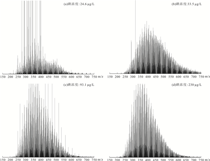
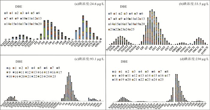

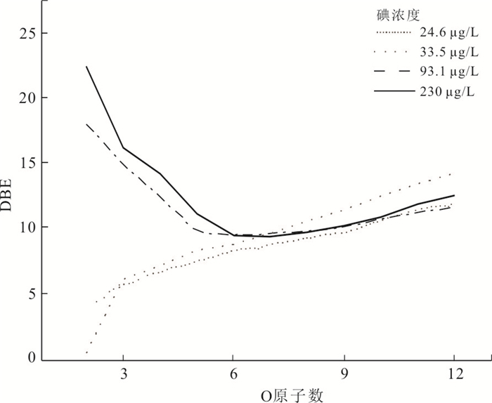
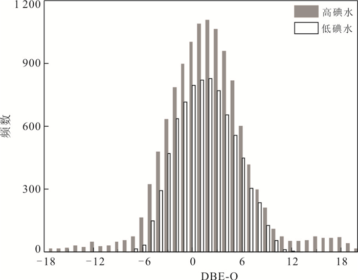
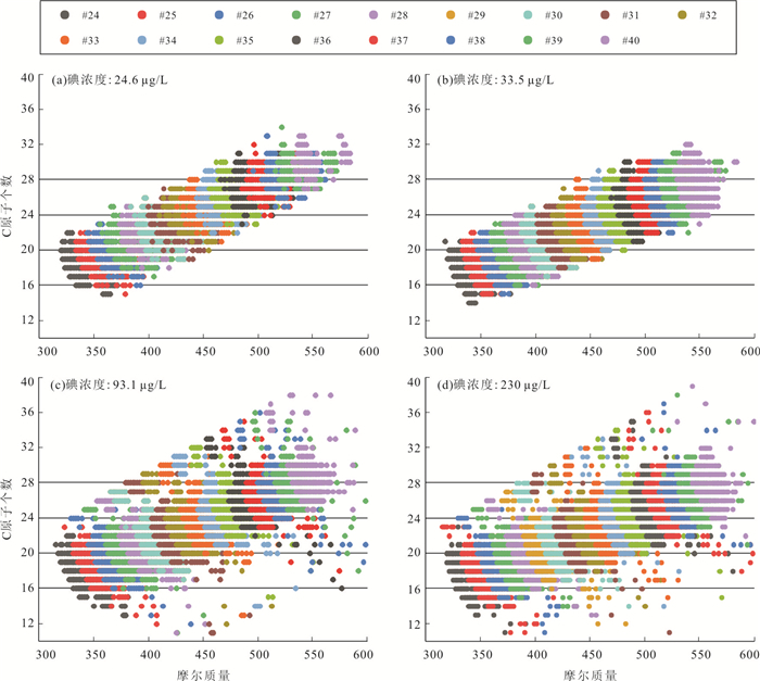
2021, 46(11): 4150-4160.
doi: 10.3799/dqkx.2020.268
Abstract:
In order to investigate the effect of different hydraulic parameter estimation methods of the heterogenous aquifer on predicting groundwater flow and solute transport simulation, based on the laboratory heterogeneous aquifer sandbox, conventional equivalent homogeneous model, kriging and hydraulic tomography are used to characterize heterogeneity of the sandbox aquifer. The role of priori information on improving hydraulic tomography inversion is discussed. The K estimated by different methods are used to predict the process of steady-state groundwater flow and solute transport, which evaluates the merits and demerits of different K estimation methods. Afterwards, we investigate the effect of aquifer heterogeneity on groundwater flow and solute transport. The results reveal that compared with kriging, hydraulic tomography can get higher precision to characterize aquifer heterogeneity and predict the process of groundwater flow and solute transport. The K values from 40 core samples are used as prior information of hydraulic tomography can promote the accuracy of K estimates. The conventional equivalent homogeneous model cannot accurately predict the process of groundwater flow and solute transport in heterogeneous aquifer. The enhancement of aquifer heterogeneity will lead to the enhancement of the spatial variability of tracer distribution and migration path, and the dominant channel directly determines the migration path and tracer distribution.
In order to investigate the effect of different hydraulic parameter estimation methods of the heterogenous aquifer on predicting groundwater flow and solute transport simulation, based on the laboratory heterogeneous aquifer sandbox, conventional equivalent homogeneous model, kriging and hydraulic tomography are used to characterize heterogeneity of the sandbox aquifer. The role of priori information on improving hydraulic tomography inversion is discussed. The K estimated by different methods are used to predict the process of steady-state groundwater flow and solute transport, which evaluates the merits and demerits of different K estimation methods. Afterwards, we investigate the effect of aquifer heterogeneity on groundwater flow and solute transport. The results reveal that compared with kriging, hydraulic tomography can get higher precision to characterize aquifer heterogeneity and predict the process of groundwater flow and solute transport. The K values from 40 core samples are used as prior information of hydraulic tomography can promote the accuracy of K estimates. The conventional equivalent homogeneous model cannot accurately predict the process of groundwater flow and solute transport in heterogeneous aquifer. The enhancement of aquifer heterogeneity will lead to the enhancement of the spatial variability of tracer distribution and migration path, and the dominant channel directly determines the migration path and tracer distribution.


2021, 46(11): 4161-4174.
doi: 10.3799/dqkx.2020.370
Abstract:
Kushui lake is a newfound lithium-rich salt lake in the West Kunlun Mountain hinterland of Tibetan plateau. It is of great significance to find out the characteristics of hydrochemical composition for enriching the basic data of the Li-rich brines deposits on the Tibetan plateau. However, limited by the regional physical and geographical conditions, the basic research on the brine and recharge water system of the salt lake has not been reported yet. Piper diagram, Gibbs diagram and ion ratio analysis method were comprehensively used to discuss the chemical composition, evolution and main ion sources of the surface brine and the peripheral recharge system. The results show that from "source" to "sink", not only the composition of each ion is changed significantly but also the hydrochemical type shows transition from carbonate-type to sodium sulfate subtype, and the evolution of hydrochemistry in water changes from rock weathering control to evaporation crystallization control. According to the ion content ratio relationship, three main ion sources were identified. (1)The weathering products of carbonate and silicate are the main solute in the recharge water system of northeastern Kushui lake. (2)The Tianshui lake recharge water system in the southern part of the lake mainly supplies evaporate dissolved substances. (3)There may be solute sources in the cold spring around the lake from mixed fluid of syn-sedimentary brine and shallow groundwater, or the leaching products of felsic volcanic rocks and carbonatite.
Kushui lake is a newfound lithium-rich salt lake in the West Kunlun Mountain hinterland of Tibetan plateau. It is of great significance to find out the characteristics of hydrochemical composition for enriching the basic data of the Li-rich brines deposits on the Tibetan plateau. However, limited by the regional physical and geographical conditions, the basic research on the brine and recharge water system of the salt lake has not been reported yet. Piper diagram, Gibbs diagram and ion ratio analysis method were comprehensively used to discuss the chemical composition, evolution and main ion sources of the surface brine and the peripheral recharge system. The results show that from "source" to "sink", not only the composition of each ion is changed significantly but also the hydrochemical type shows transition from carbonate-type to sodium sulfate subtype, and the evolution of hydrochemistry in water changes from rock weathering control to evaporation crystallization control. According to the ion content ratio relationship, three main ion sources were identified. (1)The weathering products of carbonate and silicate are the main solute in the recharge water system of northeastern Kushui lake. (2)The Tianshui lake recharge water system in the southern part of the lake mainly supplies evaporate dissolved substances. (3)There may be solute sources in the cold spring around the lake from mixed fluid of syn-sedimentary brine and shallow groundwater, or the leaching products of felsic volcanic rocks and carbonatite.


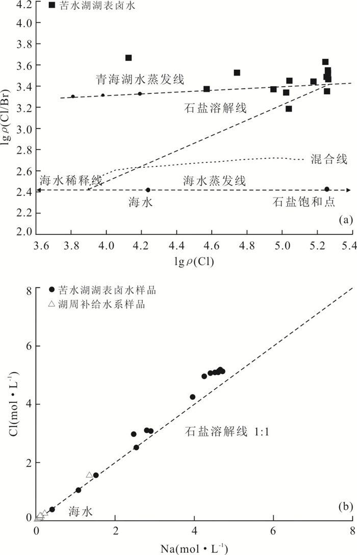
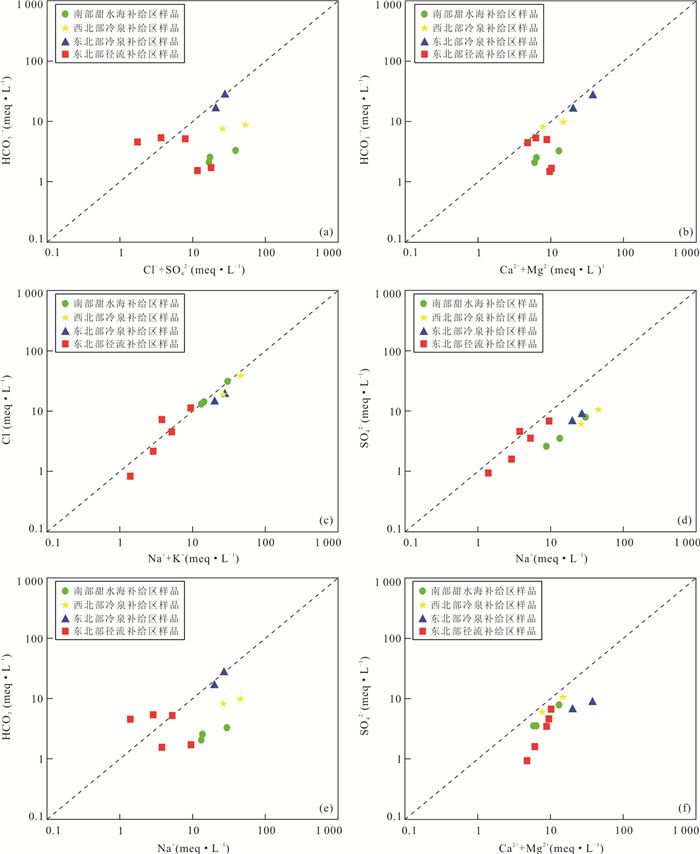
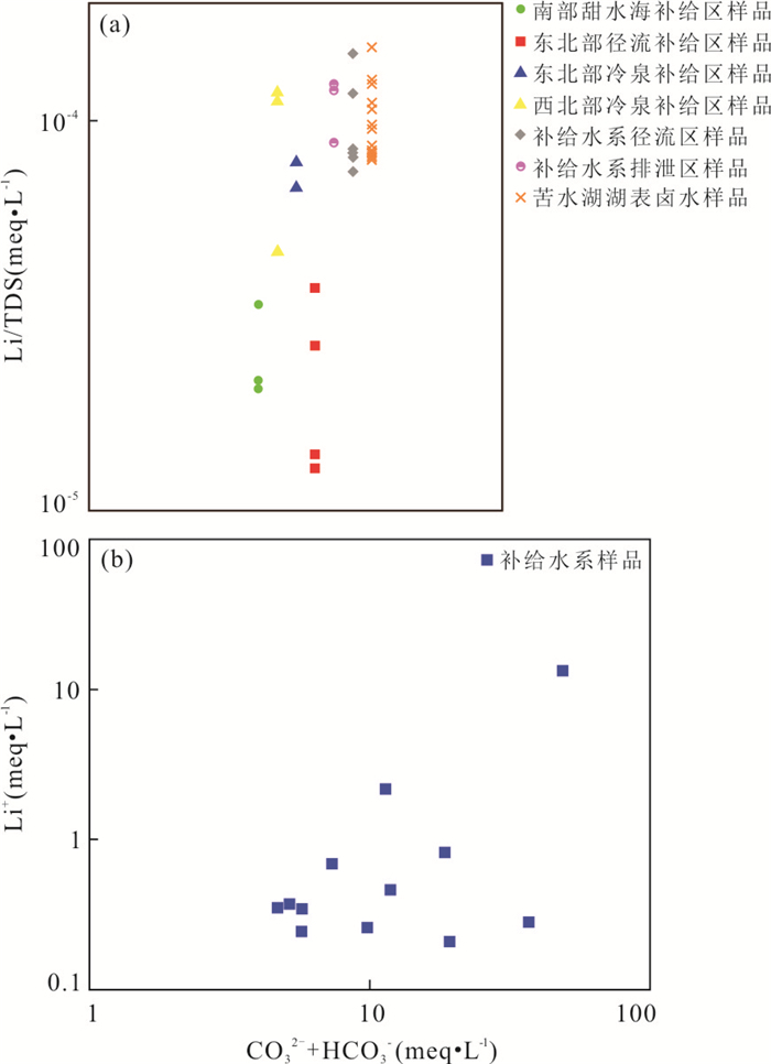
2021, 46(11): 4175-4187.
doi: 10.3799/dqkx.2020.401
Abstract:
Carbonatite geothermal reservoir with freshwater is widespread in Southwest China. Anning low temperature geothermal field, which has a dual vertical structure, is approximately 40 km adjacent to the west of Kunming geothermal field. For exploring formation of geothermal field and discovering flow channel through which deeper thermal water flows upwards to the upper reservoir under a poor-drilling data condition, three methods are employed in this paper. (1) Hydro-geochemical characteristics of the deeper reservoir (Dengying Formation) is determined with an analogy to the similar reservoir (also Dengying Formation) of Kunming geothermal field. (2) Sodium is recognized as a possible indicator of flow channel to the upper reservoir by elaborating the difference and connection between upper reservoir (Qixia-Maokou Formation) and deeper reservoir in consideration of water-rock interaction, hydrochemistry type and correlation of main ions. (3) An inverse numerical model, including exploitation quantity and measured thermal water temperature, is used to verify the rationality of channel location. Thermal water in upper reservoir is mixture, whose ion concentration is distinctive from the deeper thermal water, and its hydrochemistry type (HCO3-Ca·Mg) is controlled by cold water around obviously. There are slight differences of hydrochemical characteristics among geothermal producing wells, except for sodium distribution, which is corresponding with the distribution of water temperature and exploitation status. The locations of flow channel obtained through hydrochemical data are well matched with numerical simulation results, which suggests that the inferring of flow channels through synthetical analyses mainly based upon the distribution of sodium may be feasible.
Carbonatite geothermal reservoir with freshwater is widespread in Southwest China. Anning low temperature geothermal field, which has a dual vertical structure, is approximately 40 km adjacent to the west of Kunming geothermal field. For exploring formation of geothermal field and discovering flow channel through which deeper thermal water flows upwards to the upper reservoir under a poor-drilling data condition, three methods are employed in this paper. (1) Hydro-geochemical characteristics of the deeper reservoir (Dengying Formation) is determined with an analogy to the similar reservoir (also Dengying Formation) of Kunming geothermal field. (2) Sodium is recognized as a possible indicator of flow channel to the upper reservoir by elaborating the difference and connection between upper reservoir (Qixia-Maokou Formation) and deeper reservoir in consideration of water-rock interaction, hydrochemistry type and correlation of main ions. (3) An inverse numerical model, including exploitation quantity and measured thermal water temperature, is used to verify the rationality of channel location. Thermal water in upper reservoir is mixture, whose ion concentration is distinctive from the deeper thermal water, and its hydrochemistry type (HCO3-Ca·Mg) is controlled by cold water around obviously. There are slight differences of hydrochemical characteristics among geothermal producing wells, except for sodium distribution, which is corresponding with the distribution of water temperature and exploitation status. The locations of flow channel obtained through hydrochemical data are well matched with numerical simulation results, which suggests that the inferring of flow channels through synthetical analyses mainly based upon the distribution of sodium may be feasible.


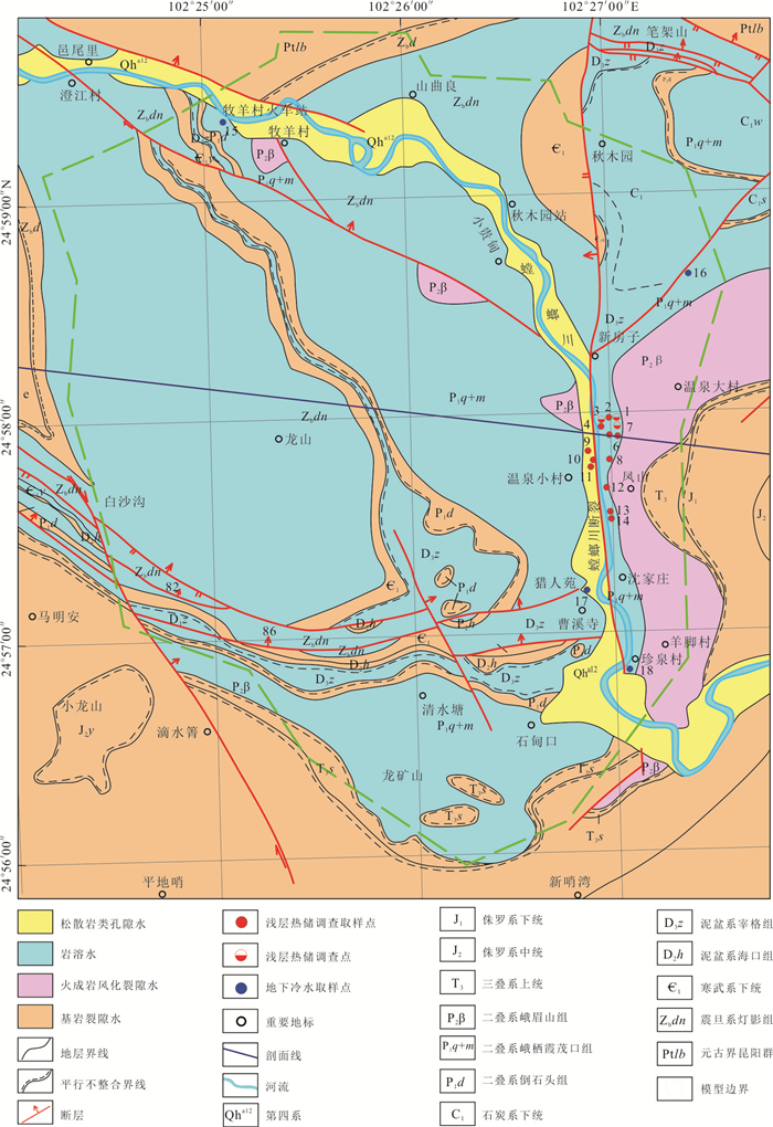
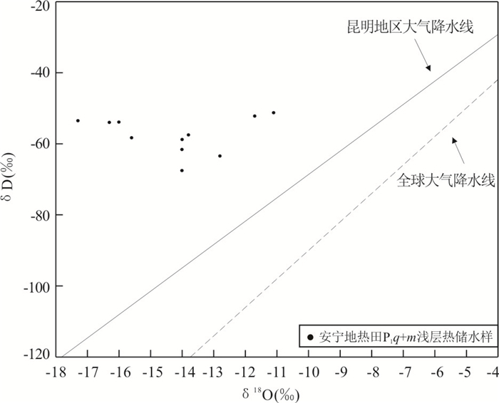


2021, 46(11): 4188-4196.
doi: 10.3799/dqkx.2021.026
Abstract:
Paleoclimate and paleobrine temperature conditions are closely related to potassium formation in salt lakes. Quantitatively reconstructing evolution characteristics of paleobrine temperature during Early Eocene salt-forming period of the Kuqa basin has important scientific significance for evaluating the potash potential of the basin. In this paper it takes Lower Eocene rock salt of core QL1 which is located in the western Kuqa basin as research object for the first time. Based on the detailed petrographic research, the test and analysis of homogenization temperature of primary fluid inclusions of halite were carried out. The analysis results show that a total of 135 homogenization temperature data were obtained from six samples with different depths of the borehole, ranging from 21.2 to 57.8℃, with an average value of 31.8℃, the profile shows a slight warming trend from bottom to top in the vertical direction. The characteristics of homogenization temperature range, average homogenization temperature, and maximum homogenization temperature measured in this paper are consistent with the temperature data of the Tethys seawater in the same period, which further indicates reliability and rationality of homogenization temperature data. In addition, the high temperature condition is conducive to strong evaporation and concentration of water bodies, which is in good agreement with the thick evaporite series and potassium minerals deposited in the Early Eocene of the Kuqa basin.
Paleoclimate and paleobrine temperature conditions are closely related to potassium formation in salt lakes. Quantitatively reconstructing evolution characteristics of paleobrine temperature during Early Eocene salt-forming period of the Kuqa basin has important scientific significance for evaluating the potash potential of the basin. In this paper it takes Lower Eocene rock salt of core QL1 which is located in the western Kuqa basin as research object for the first time. Based on the detailed petrographic research, the test and analysis of homogenization temperature of primary fluid inclusions of halite were carried out. The analysis results show that a total of 135 homogenization temperature data were obtained from six samples with different depths of the borehole, ranging from 21.2 to 57.8℃, with an average value of 31.8℃, the profile shows a slight warming trend from bottom to top in the vertical direction. The characteristics of homogenization temperature range, average homogenization temperature, and maximum homogenization temperature measured in this paper are consistent with the temperature data of the Tethys seawater in the same period, which further indicates reliability and rationality of homogenization temperature data. In addition, the high temperature condition is conducive to strong evaporation and concentration of water bodies, which is in good agreement with the thick evaporite series and potassium minerals deposited in the Early Eocene of the Kuqa basin.