2021 Vol. 46, No. 2
Display Method:
 PDF 511KB
2021, 46(2): 381-404.
doi: 10.3799/dqkx.2020.348
Abstract:
Fragments of intraplate ocean island-seamount are important parts of "oceanic crust fragments" in the orogenic belt, and these fragments place important constraints on restoring the tectonic evolution of the ancient ocean basin represented by the orogenic belt. However, the identification method and geological significance of the intraplate ocean island-seamount fragments in the orogenic belt are poorly known. Based on the review of the lithological sequence, magmatic rock types, geochemistry, and isotopic characteristics of the intraplate ocean island-seamounts in the modern ocean basin and our research results on several intraplate ocean island-seamount fragments in the Bangongco-Nujiang suture zone in the Tibetan Plateau, in this study it summarizes the identification method, age determination method, and geological significance of the intraplate ocean island-seamount fragments in the orogenic belt. Intraplate ocean island-seamounts record extensive information about the tectonic evolution of the ocean basin, and these are the easiest oceanic geological bodies to preserve during the subduction of the oceanic lithosphere. Therefore, studies on the intraplate ocean island-seamount fragments in the orogenic belt are very important in restoring the tectonic evolution of the ancient ocean basin.
Fragments of intraplate ocean island-seamount are important parts of "oceanic crust fragments" in the orogenic belt, and these fragments place important constraints on restoring the tectonic evolution of the ancient ocean basin represented by the orogenic belt. However, the identification method and geological significance of the intraplate ocean island-seamount fragments in the orogenic belt are poorly known. Based on the review of the lithological sequence, magmatic rock types, geochemistry, and isotopic characteristics of the intraplate ocean island-seamounts in the modern ocean basin and our research results on several intraplate ocean island-seamount fragments in the Bangongco-Nujiang suture zone in the Tibetan Plateau, in this study it summarizes the identification method, age determination method, and geological significance of the intraplate ocean island-seamount fragments in the orogenic belt. Intraplate ocean island-seamounts record extensive information about the tectonic evolution of the ocean basin, and these are the easiest oceanic geological bodies to preserve during the subduction of the oceanic lithosphere. Therefore, studies on the intraplate ocean island-seamount fragments in the orogenic belt are very important in restoring the tectonic evolution of the ancient ocean basin.


2021, 46(2): 405-417.
doi: 10.3799/dqkx.2020.022
Abstract:
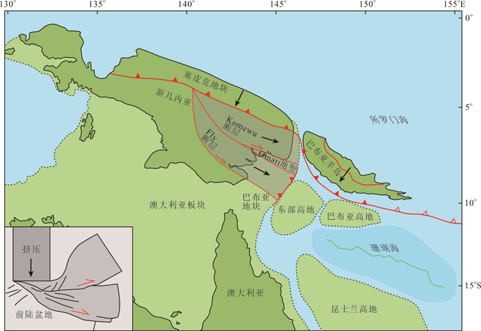
The Gulf of Papua has undergone complex evolution due to the oblique and rapid converging between the Australian and Pacific plates in boundary zone. However, since previous studies on the basin structural characteristics of the Gulf of Papua are mostly local and dispersed, the formation time and dynamics mechanism of the basin are still controversial. In this paper, the structural characteristics of the basin are described by using the high-precision 2D and 3D seismic data with drilling constraints covering the whole basin. It is revealed that there are two superposed foreland basins of Pandora and Aure foreland basins in the Gulf of Papua. The Pandora foreland basin is a Late Oligocene-Middle Miocene micro-foreland basin formed on the unconformity of the Oligocene trending NNE. The Aure foreland basin is an Early Miocene-Present peripheral foreland basin developed on the complex rift margin, extending 480 km along the curved Papua peninsula. The basin trend changes from NW in the west to near EW in the east at longitude 148°E. The Pandora micro-foreland basin is covered by sedimentary strata of the Aure foreland basin that gradually onlaps southward. The two foreland basins strike perpendicular to each other and form a superimposed structure vertically. This study elucidates the evolution of the two superimposed foreland basins of the Gulf of Papua, which underwent three-stage extrusion event in the Cenozoic, solving the lack of understanding of basin structure and regional tectonic evolution. In this paper, the temporal sequence and dynamic mechanism of the multi-stage tectonic events in the complex continental margin from extensional to compressional are clarified, providing evidence for plate tectonic reconstruction in the northern margin of the Australian Plate.
The Gulf of Papua has undergone complex evolution due to the oblique and rapid converging between the Australian and Pacific plates in boundary zone. However, since previous studies on the basin structural characteristics of the Gulf of Papua are mostly local and dispersed, the formation time and dynamics mechanism of the basin are still controversial. In this paper, the structural characteristics of the basin are described by using the high-precision 2D and 3D seismic data with drilling constraints covering the whole basin. It is revealed that there are two superposed foreland basins of Pandora and Aure foreland basins in the Gulf of Papua. The Pandora foreland basin is a Late Oligocene-Middle Miocene micro-foreland basin formed on the unconformity of the Oligocene trending NNE. The Aure foreland basin is an Early Miocene-Present peripheral foreland basin developed on the complex rift margin, extending 480 km along the curved Papua peninsula. The basin trend changes from NW in the west to near EW in the east at longitude 148°E. The Pandora micro-foreland basin is covered by sedimentary strata of the Aure foreland basin that gradually onlaps southward. The two foreland basins strike perpendicular to each other and form a superimposed structure vertically. This study elucidates the evolution of the two superimposed foreland basins of the Gulf of Papua, which underwent three-stage extrusion event in the Cenozoic, solving the lack of understanding of basin structure and regional tectonic evolution. In this paper, the temporal sequence and dynamic mechanism of the multi-stage tectonic events in the complex continental margin from extensional to compressional are clarified, providing evidence for plate tectonic reconstruction in the northern margin of the Australian Plate.


2021, 46(2): 418-431.
doi: 10.3799/dqkx.2020.066
Abstract:
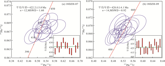
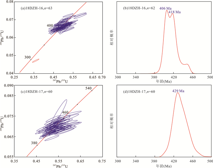
There are great controversies in the time of Dawazi Formation located at the edges of western Simao Block. Siliceous rocks, sandstones and volcanic rocks in Dazhonghe Section, western Simao Block were selected to research the geological time by the radiolarian assemblage and zircon U-Pb age, and reconstruct the stratigraphic sequence. Dazhonghe Section is a fragment stratum system composed of six different lithologic strata fragments, through the detailed section measurement. The first and forth fragments are characterized by radiolaria-bearing siliceous rocks, and the radiolarian assemblage indicates that the geological age is from Late Devonian to Early Carboniferous. The second and fifth fragments are dominated by pyroclastic rocks and pyroclastic sedimentary rocks with Bouma sequence characteristics. The U-Pb isotope ages of the zircons indicate that the geological age is from the Middle Silurian to the Early Devonian. The third and sixth fragments are characterized by volcanic rock deposition, and the U-Pb isotope age of zircons indicates that the geological age is the Early Silurian. Combined with the previous data, it is believed that the stratigraphic sequences of marine volcanic rocks, clastic rocks and radiolarian-bearing siliceous rocks distributed in the western margin of Simao Block represent the island-arc volcanic-sedimentary stratigraphic sequences from Silurian to Early Carboniferous.
There are great controversies in the time of Dawazi Formation located at the edges of western Simao Block. Siliceous rocks, sandstones and volcanic rocks in Dazhonghe Section, western Simao Block were selected to research the geological time by the radiolarian assemblage and zircon U-Pb age, and reconstruct the stratigraphic sequence. Dazhonghe Section is a fragment stratum system composed of six different lithologic strata fragments, through the detailed section measurement. The first and forth fragments are characterized by radiolaria-bearing siliceous rocks, and the radiolarian assemblage indicates that the geological age is from Late Devonian to Early Carboniferous. The second and fifth fragments are dominated by pyroclastic rocks and pyroclastic sedimentary rocks with Bouma sequence characteristics. The U-Pb isotope ages of the zircons indicate that the geological age is from the Middle Silurian to the Early Devonian. The third and sixth fragments are characterized by volcanic rock deposition, and the U-Pb isotope age of zircons indicates that the geological age is the Early Silurian. Combined with the previous data, it is believed that the stratigraphic sequences of marine volcanic rocks, clastic rocks and radiolarian-bearing siliceous rocks distributed in the western margin of Simao Block represent the island-arc volcanic-sedimentary stratigraphic sequences from Silurian to Early Carboniferous.


2021, 46(2): 432-443.
doi: 10.3799/dqkx.2020.059
Abstract:
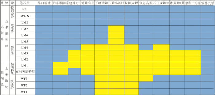
The black shale of Wufeng Formation of Upper Ordovician and Longmaxi Formation of Lower Silurian is developed in Jianshi area of West Hubei, but no paleontological stratigraphic sequence has been established. Based on drill core of Well JD-1, the top and bottom boundaries and black graptolite shale sequences from the Wufeng Formation to the Longmaxi Formation in Jianshi area are studied. The evolution model of Xiang'e underwater highland during the Ordovician-Silurian boundary period and its influence on shale gas exploration are discussed. Well JD-1 occured eight graptolitic biozones between Late Ordovican (Katian) Dicellograptus complexus Zone and Llandovery (Aeronian) Stimulograptus sedgwicki Zone, missing three graptolitic biozones, including the Perculpto gr. perculptus Zone, Akidograptus ascensus Zone and Parakido gr. acuminatus Zone. It is confirmed that Jianshi area was located in the Xiang'e underwater highland during the period from the Hernant to the early Ludan. The Xiang'e underwater highland is developed in the border area of Hubei and Hunan provinces, which is mainly controlled by global sea level change and the Guangxi movement caused by agglomeration and ablation of Gondwana continental glacier, and the overall situation shows that the evolution is constantly rising from the Kaidi to the Early Rhuddanian, the influence scope is gradually expanding, and then gradually shrinks back in the Early-Middle Rhuddanian. The results suggest that the ability of shale gas reservoirs to resist structural damage is weak and the exploration risk is high in Jianshi area, due to the lack of organic-rich shale from WF3 to LM4.
The black shale of Wufeng Formation of Upper Ordovician and Longmaxi Formation of Lower Silurian is developed in Jianshi area of West Hubei, but no paleontological stratigraphic sequence has been established. Based on drill core of Well JD-1, the top and bottom boundaries and black graptolite shale sequences from the Wufeng Formation to the Longmaxi Formation in Jianshi area are studied. The evolution model of Xiang'e underwater highland during the Ordovician-Silurian boundary period and its influence on shale gas exploration are discussed. Well JD-1 occured eight graptolitic biozones between Late Ordovican (Katian) Dicellograptus complexus Zone and Llandovery (Aeronian) Stimulograptus sedgwicki Zone, missing three graptolitic biozones, including the Perculpto gr. perculptus Zone, Akidograptus ascensus Zone and Parakido gr. acuminatus Zone. It is confirmed that Jianshi area was located in the Xiang'e underwater highland during the period from the Hernant to the early Ludan. The Xiang'e underwater highland is developed in the border area of Hubei and Hunan provinces, which is mainly controlled by global sea level change and the Guangxi movement caused by agglomeration and ablation of Gondwana continental glacier, and the overall situation shows that the evolution is constantly rising from the Kaidi to the Early Rhuddanian, the influence scope is gradually expanding, and then gradually shrinks back in the Early-Middle Rhuddanian. The results suggest that the ability of shale gas reservoirs to resist structural damage is weak and the exploration risk is high in Jianshi area, due to the lack of organic-rich shale from WF3 to LM4.


2021, 46(2): 444-459.
doi: 10.3799/dqkx.2020.104
Abstract:
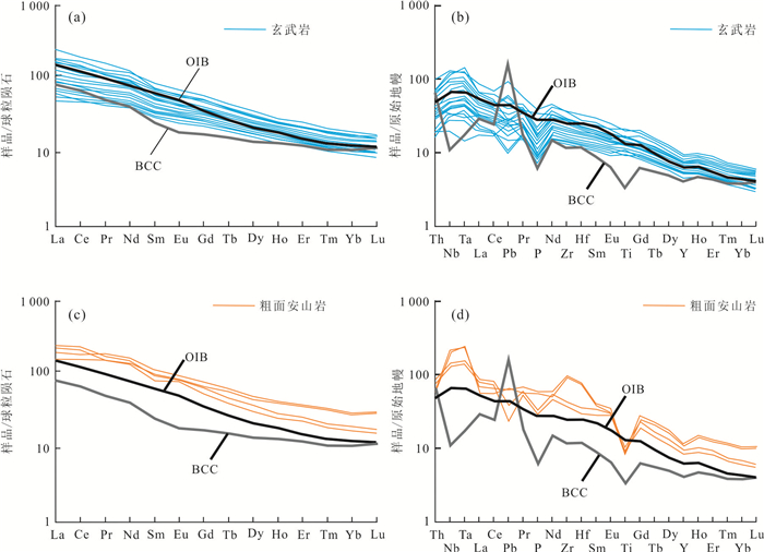
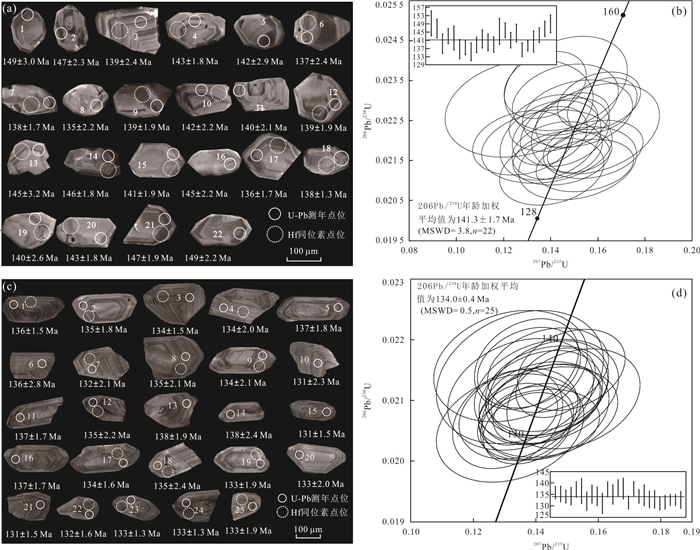
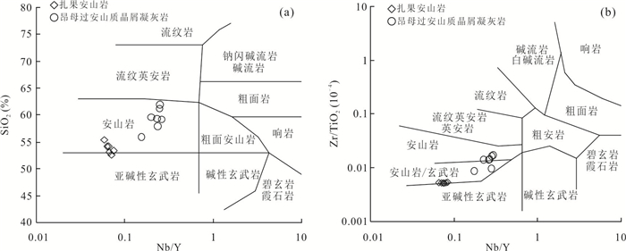
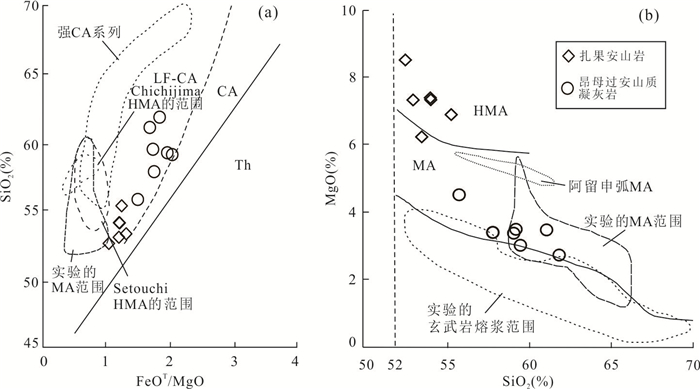
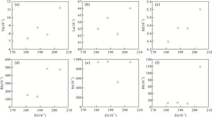
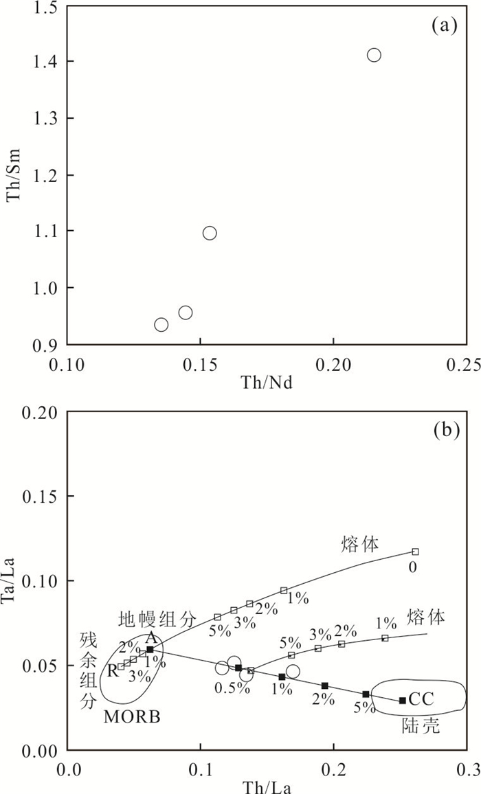
The tectonic-magmatic evolution of the Banggongco-Nujiang suture zone is one of the hottest scientific problems related to fundamental geology of the Tibetan Plateau. The Mesozoic volcanic-intrusive rocks are widely distributed in the North Gangdese belt, which is also located in the southern of the Banghongco-Nujiang suture zone. However, the petrogenesis and geodynamic setting of those rocks remain under debate. It reports the newly found vocalic rock dissections from Shamuluo Formation in Awengcuo area, which are located at the west segment of Bangongco-Nujiang suture zone to explore these issues. Those rocks consist of lower dissection named Zhaguo andesite and central dissection named Angmuguo andesistic crystal tuff. Zircon U-Pb dating indicates that the Zhaguo andesite was emplaced at 141.3±1.7 Ma, and the Angmuguo andesistic crystal tuff was formed in the age of 134.0±0.4 Ma, which provides new chronological data for the Shamuluo Formation. The Zhaguo andesite exhibits SiO2contents of 52.58%-55.35%, Al2O3 contents of 14.43%-15.44% with A/CNK ranging from 0.58 to 0.75, MgO contents of 6.12%-8.51%, Na2O contents of 1.55%-5.03%, with Na2O/K2O ratios of 1.81-3.61 and Mg numbers of 57.6-63.2 (average in 59.8), which can be assigned to high-Mg andesite. The Angmuguo andesistic crystal tuff has contents of SiO2 (55.83%-61.88%), MgO (2.73%-4.51%), Al2O3(17.75%-19.62%) with A/CNK of 0.90-1.08, Na2O(1.55%-5.03%), and Na2O/K2O (1.81-3.61). All these samples are sodic low-K calc-alkaline series, and enriched in large ion lithopile elements (LILE) and depleted in high field strength elements (HFSE), showing a similar character of island arc-type magmas. The zircon εHf(t) of Zhaguo andesite values are +15.5 to +18.7, and the Angmuguo andesistic crystal tuff values from +13.8 to +16.2, indicating that these rocks came from the partial melting of newly-formed lower crust. The Zhaguo high-Mg andesite has low contents of Y (11.9×10⁻⁶-13.5×10⁻⁶), Yb (1.32×10⁻⁶-1.43×10⁻⁶), and high Sr (481×10-6-794×10-6) with the ratios of Sr/Y (35.6-65.6) and LaN/YbN(8.2-10.4). The melt of subducted slab and metasomic mantle peridoite played a great role on its forming process. Based on the above data, it is proposed that the volcanic rock magma from Shamuoluo Formation formed in inland-arc setting, which can be the early magma response of Bangongco-Nujiang Tethyan Ocean's southward subduction.
The tectonic-magmatic evolution of the Banggongco-Nujiang suture zone is one of the hottest scientific problems related to fundamental geology of the Tibetan Plateau. The Mesozoic volcanic-intrusive rocks are widely distributed in the North Gangdese belt, which is also located in the southern of the Banghongco-Nujiang suture zone. However, the petrogenesis and geodynamic setting of those rocks remain under debate. It reports the newly found vocalic rock dissections from Shamuluo Formation in Awengcuo area, which are located at the west segment of Bangongco-Nujiang suture zone to explore these issues. Those rocks consist of lower dissection named Zhaguo andesite and central dissection named Angmuguo andesistic crystal tuff. Zircon U-Pb dating indicates that the Zhaguo andesite was emplaced at 141.3±1.7 Ma, and the Angmuguo andesistic crystal tuff was formed in the age of 134.0±0.4 Ma, which provides new chronological data for the Shamuluo Formation. The Zhaguo andesite exhibits SiO2contents of 52.58%-55.35%, Al2O3 contents of 14.43%-15.44% with A/CNK ranging from 0.58 to 0.75, MgO contents of 6.12%-8.51%, Na2O contents of 1.55%-5.03%, with Na2O/K2O ratios of 1.81-3.61 and Mg numbers of 57.6-63.2 (average in 59.8), which can be assigned to high-Mg andesite. The Angmuguo andesistic crystal tuff has contents of SiO2 (55.83%-61.88%), MgO (2.73%-4.51%), Al2O3(17.75%-19.62%) with A/CNK of 0.90-1.08, Na2O(1.55%-5.03%), and Na2O/K2O (1.81-3.61). All these samples are sodic low-K calc-alkaline series, and enriched in large ion lithopile elements (LILE) and depleted in high field strength elements (HFSE), showing a similar character of island arc-type magmas. The zircon εHf(t) of Zhaguo andesite values are +15.5 to +18.7, and the Angmuguo andesistic crystal tuff values from +13.8 to +16.2, indicating that these rocks came from the partial melting of newly-formed lower crust. The Zhaguo high-Mg andesite has low contents of Y (11.9×10⁻⁶-13.5×10⁻⁶), Yb (1.32×10⁻⁶-1.43×10⁻⁶), and high Sr (481×10-6-794×10-6) with the ratios of Sr/Y (35.6-65.6) and LaN/YbN(8.2-10.4). The melt of subducted slab and metasomic mantle peridoite played a great role on its forming process. Based on the above data, it is proposed that the volcanic rock magma from Shamuoluo Formation formed in inland-arc setting, which can be the early magma response of Bangongco-Nujiang Tethyan Ocean's southward subduction.


2021, 46(2): 460-473.
doi: 10.3799/dqkx.2020.087
Abstract:
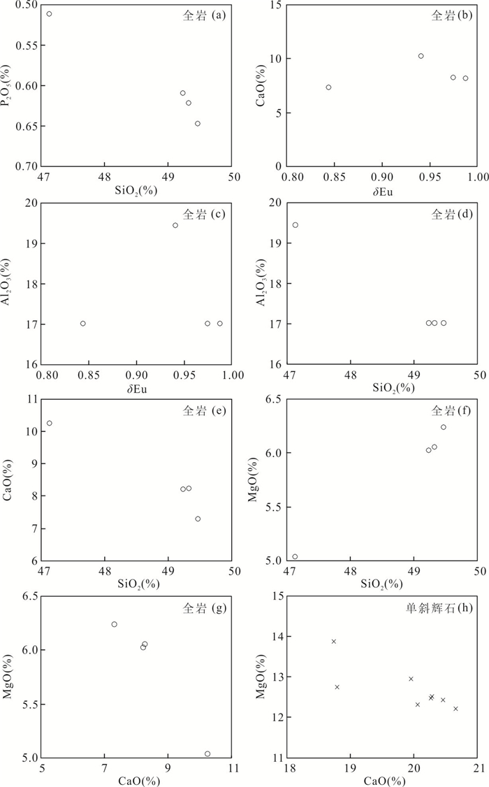
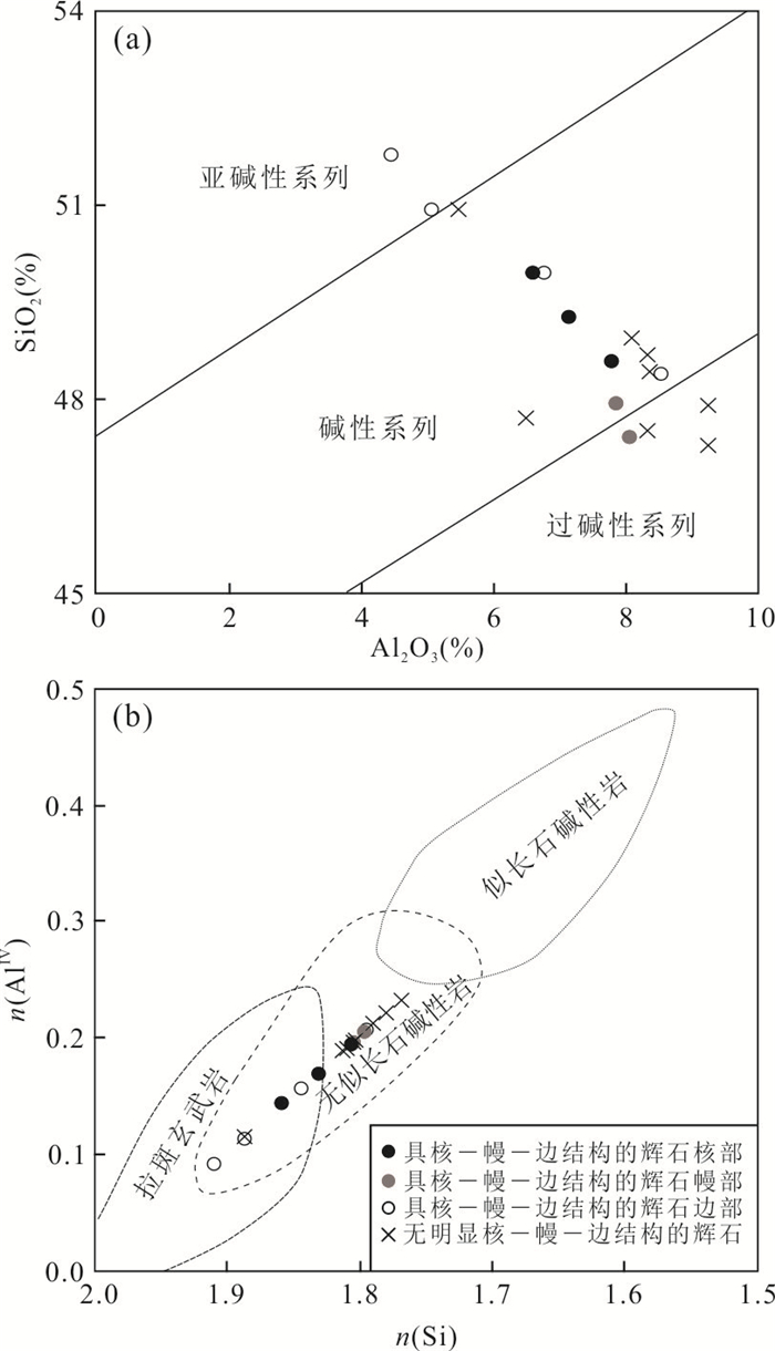
The Mesozoic basic igneous rock in South China is dominated by tholeiite series, while the alkali series is rare. Bimodal intrusive pluton composed of alkali diabase porphyrite and A-type granite occurs in Tiemuli area, Chongyi County, Jiangxi Province. Mineralogical, geochronological and geochemical analyses of the diabase porphyrite were carried out. The Tiemuli diabase porphyrite displays porphyritic texture.Phenocrysts are dominated by salite, with minor diopside and augite, while groundmass minerals comprise andesite (with Ab values of 39.11%-43.30%), kaersutite and clinopyroxene chemically equivalent to phenocrysts. The diabase porphyrite was emplaced after the granite (136.6 Ma) and belongs to alkali basalt series, characterized by low SiO2 (41.73%-46.68%) and TiO2 (1.72%-1.94%) contents, high TFeO (7.64%-9.24%), Al2O3 (15.70%-17.22%) and alkali (5.28%-6.60%) contents, and moderate Mg# values (molar ratios of MgO/(MgO+TFeO), 0.51-0.54). The fractionation between light rare earth elements (LREEs) and high rare earth elements (HREEs) and fractionation of LREEs are remarkable ((La/Yb)N=17.58-22.28, (La/Sm)N=4.72-5.18), while the Eu anormalies are negligible (δEu=0.84-0.99). All rocks are significantly enriched in large iron lithophile elements (LILEs) and are slightly enriched in high field strength elements (HFSEs), with lower contents of transition elements than primitive mantle. They have εNd, (87Sr/86Sr)i, (206Pb/204Pb)i, (207Pb/204Pb)i and (208Pb/204Pb)i values of +3.45, 0.707 5, 18.769 9, 15.733 7 and 39.110 0, respectively, displaying transitional features between OIB and EMII. Mineralogical, geochemical and Nd-Hf isotopic characteristics suggest that the Tiemuli diabase porphyrite was generated in asthenosphere and the partial melting took place in garnet stability field. The alkali basalt magma was derived from small degree of decompression melting of depleted asthenospheric mantle and contamination of crustal materials was minor. Fractional crystallization of clinopyroxene, apatite and Fe-Ti oxides took place during the basaltic magma evolution. Some enriched components from lithospheric mantle might be involved in. The Cretaceous alkali basaltic rocks developed interior of South China were formed in intracontinental extension (rift-like) regime related to regional lithospheric extension and deep-penetrating faults.
The Mesozoic basic igneous rock in South China is dominated by tholeiite series, while the alkali series is rare. Bimodal intrusive pluton composed of alkali diabase porphyrite and A-type granite occurs in Tiemuli area, Chongyi County, Jiangxi Province. Mineralogical, geochronological and geochemical analyses of the diabase porphyrite were carried out. The Tiemuli diabase porphyrite displays porphyritic texture.Phenocrysts are dominated by salite, with minor diopside and augite, while groundmass minerals comprise andesite (with Ab values of 39.11%-43.30%), kaersutite and clinopyroxene chemically equivalent to phenocrysts. The diabase porphyrite was emplaced after the granite (136.6 Ma) and belongs to alkali basalt series, characterized by low SiO2 (41.73%-46.68%) and TiO2 (1.72%-1.94%) contents, high TFeO (7.64%-9.24%), Al2O3 (15.70%-17.22%) and alkali (5.28%-6.60%) contents, and moderate Mg# values (molar ratios of MgO/(MgO+TFeO), 0.51-0.54). The fractionation between light rare earth elements (LREEs) and high rare earth elements (HREEs) and fractionation of LREEs are remarkable ((La/Yb)N=17.58-22.28, (La/Sm)N=4.72-5.18), while the Eu anormalies are negligible (δEu=0.84-0.99). All rocks are significantly enriched in large iron lithophile elements (LILEs) and are slightly enriched in high field strength elements (HFSEs), with lower contents of transition elements than primitive mantle. They have εNd, (87Sr/86Sr)i, (206Pb/204Pb)i, (207Pb/204Pb)i and (208Pb/204Pb)i values of +3.45, 0.707 5, 18.769 9, 15.733 7 and 39.110 0, respectively, displaying transitional features between OIB and EMII. Mineralogical, geochemical and Nd-Hf isotopic characteristics suggest that the Tiemuli diabase porphyrite was generated in asthenosphere and the partial melting took place in garnet stability field. The alkali basalt magma was derived from small degree of decompression melting of depleted asthenospheric mantle and contamination of crustal materials was minor. Fractional crystallization of clinopyroxene, apatite and Fe-Ti oxides took place during the basaltic magma evolution. Some enriched components from lithospheric mantle might be involved in. The Cretaceous alkali basaltic rocks developed interior of South China were formed in intracontinental extension (rift-like) regime related to regional lithospheric extension and deep-penetrating faults.


2021, 46(2): 474-488.
doi: 10.3799/dqkx.2019.073
Abstract:
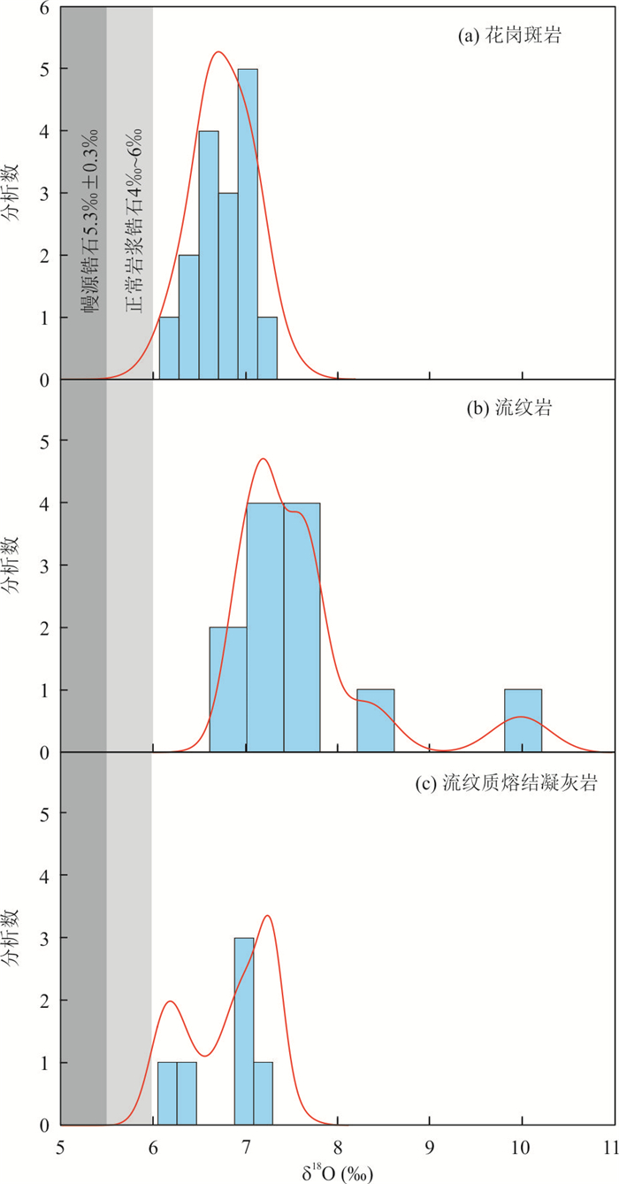
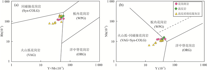
Genetic study on the granite-rhyolite associations is an essential way to uncover the mechanism of crustal evoltion. Geochemistry, zircon U-Pb dating, and oxygen isotopes of the Dengtong volcanic-plutonic complex in the central Lhasa Terrane are reported in this paper. Zircon SHRIMP U-Pb ages for the granite porphyry, rhyolite and rhyolitic ignimbrite samples are 64.1±0.8 Ma, 62.9±0.7 Ma and 63.2±0.7 Ma, respectively. These rocks display similar geochemical characterstics. They are high K calc-alkaline and weakly peraluminous, exhibit HFSE depletion, LILE and LREE enrichment, and flat HREE, with consistent zircon oxygen isotopic composition (δ18O=6.15‰-7.34‰), suggesting consecutive magma evolution of cognate origin. The rhyolite and granite porphyry are depleted in Ba, Sr, P and Ti with significant negative Eu anomaly, indicating conspicuous fractionation. The rhyolite presents the extracted melt from the mush enriched in mineral phases, while the granite porphyry generated from the mush by fractional crystallization. The rhyolitic ignimbrite displays relatively weak negative Eu anomaly, and was generated by the eruption of the residual magma mush. Considering the temporal and spatial distribution of the Paleocene magmatic rocks along the central Lhasa Terrane, it is proposed that the roll-back of the Yarlung-Zangbo Neo-Tethyan oceanic lithosphere subducted beneath the Lhasa Terrane was responsible for the geodynamic regime of the Dengtong volcanic-plutonic complex. The upwelling of the asthenosphere material caused partial melting of lower crust, and resulted in intrusive or volcanic rocks.
Genetic study on the granite-rhyolite associations is an essential way to uncover the mechanism of crustal evoltion. Geochemistry, zircon U-Pb dating, and oxygen isotopes of the Dengtong volcanic-plutonic complex in the central Lhasa Terrane are reported in this paper. Zircon SHRIMP U-Pb ages for the granite porphyry, rhyolite and rhyolitic ignimbrite samples are 64.1±0.8 Ma, 62.9±0.7 Ma and 63.2±0.7 Ma, respectively. These rocks display similar geochemical characterstics. They are high K calc-alkaline and weakly peraluminous, exhibit HFSE depletion, LILE and LREE enrichment, and flat HREE, with consistent zircon oxygen isotopic composition (δ18O=6.15‰-7.34‰), suggesting consecutive magma evolution of cognate origin. The rhyolite and granite porphyry are depleted in Ba, Sr, P and Ti with significant negative Eu anomaly, indicating conspicuous fractionation. The rhyolite presents the extracted melt from the mush enriched in mineral phases, while the granite porphyry generated from the mush by fractional crystallization. The rhyolitic ignimbrite displays relatively weak negative Eu anomaly, and was generated by the eruption of the residual magma mush. Considering the temporal and spatial distribution of the Paleocene magmatic rocks along the central Lhasa Terrane, it is proposed that the roll-back of the Yarlung-Zangbo Neo-Tethyan oceanic lithosphere subducted beneath the Lhasa Terrane was responsible for the geodynamic regime of the Dengtong volcanic-plutonic complex. The upwelling of the asthenosphere material caused partial melting of lower crust, and resulted in intrusive or volcanic rocks.


2021, 46(2): 489-503.
doi: 10.3799/dqkx.2019.059
Abstract:
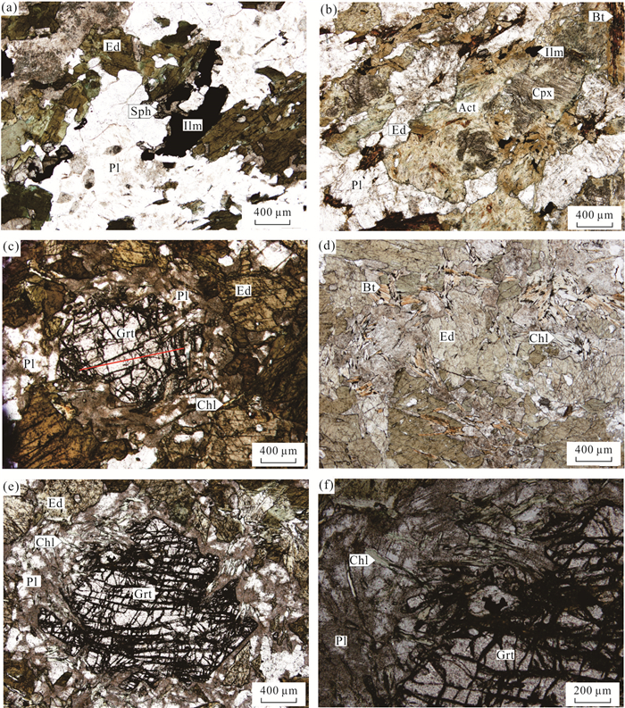
Amphibolite of the Badu complex in the Songyang area of Southwest Zhejiang Province is one of the major metamorphic rocks consisting of Precambrian metamorphic basement, However, its protolith and metamorphic evolution remain unclear. In this study, on the basis of the investigation of petrography, mineral chemistry and whole-rock major and trace element analyses, it is found that the protolith for amphilbolite belongs to high Fe tholeiite, which likely formed in an island-arc setting. The prograde metamorphic information is preserved in the garnet core, showing that peak metamorphic stage (M1) consists of garnet (rim)+edenite+plagioclase (An=40-43) +clinopyroxene+biotite+ilmenite and decompression metamorphic stage (M2) is characterized by the assemblage of actinolite + chlorite + sphene±biotite±ilmenite. By means of phase equilibrium simulation and traditional thermobarometer, it gets P-T conditions of 800-850 MPa and 710-740℃ for M1, ~480 MPa and~440℃ for M2, respectively. These P and T conditions confine a typical clockwise P-T path. Through regional comparison, the amphibolite in Badu complex may have undergone Indosinian metamorphism and the amalgamation of the Indochina with South China and North China blocks.
Amphibolite of the Badu complex in the Songyang area of Southwest Zhejiang Province is one of the major metamorphic rocks consisting of Precambrian metamorphic basement, However, its protolith and metamorphic evolution remain unclear. In this study, on the basis of the investigation of petrography, mineral chemistry and whole-rock major and trace element analyses, it is found that the protolith for amphilbolite belongs to high Fe tholeiite, which likely formed in an island-arc setting. The prograde metamorphic information is preserved in the garnet core, showing that peak metamorphic stage (M1) consists of garnet (rim)+edenite+plagioclase (An=40-43) +clinopyroxene+biotite+ilmenite and decompression metamorphic stage (M2) is characterized by the assemblage of actinolite + chlorite + sphene±biotite±ilmenite. By means of phase equilibrium simulation and traditional thermobarometer, it gets P-T conditions of 800-850 MPa and 710-740℃ for M1, ~480 MPa and~440℃ for M2, respectively. These P and T conditions confine a typical clockwise P-T path. Through regional comparison, the amphibolite in Badu complex may have undergone Indosinian metamorphism and the amalgamation of the Indochina with South China and North China blocks.


2021, 46(2): 504-526.
doi: 10.3799/dqkx.2020.036
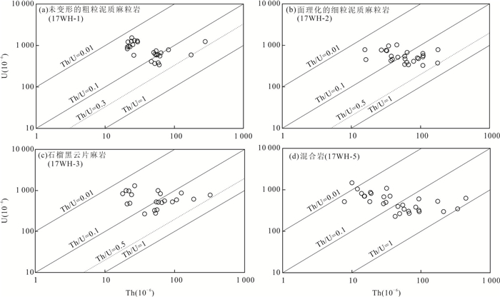
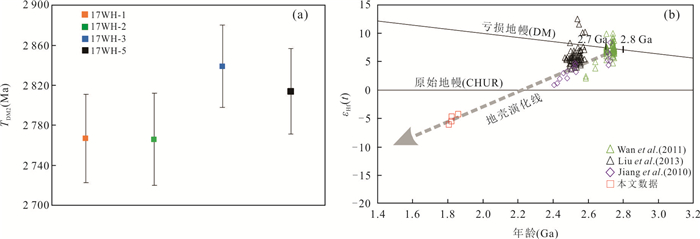
Abstract:
Paleoproterozoic pelitic granulites have been reported in Weihai region, the tectonic affinity of which is still under controversy. The pelitic granulite occur as a lens in the granitic gneisses and the lithologies of the lens gradually changes from the core to the margin, from undeformed coarse-grained granulite, foliated fine-grained granulite, garnet-biotite-gneiss to migmatized granulite. The coarse-grained pelitic granulite exhibits coarse-grained porphyroblastic texture. The fine-grained pelitic granulite shows a weakly foliated layer with a fine-grained porphyroblastic texture. The garnet-biotite-gneiss displays porphyroblastic texture. The three samples described above mainly comprise of garnet + biotite + plagioclase (antiperthite) + quartz + sillimanite. The migmatite is made up of melanosomes and leucosomes, in which the former mainly consists of garnet + plagioclase + biotite + quartz + sillimanite and the latter has mineral assemblage of quartz + plagioclase + K-feldpsar. All of the four samples contain the accessory mineral assemblage of rutile + zircon + monazite. Zircons from the coarse-grained pelitic granulite are round or elliptical in shape and show homogenous cloudy zoning or patchy zoning in internal structure, and they have low Th/U ratios (0.01-0.30, mostly < 0.1), flat HREE patterns with positive Ce and negative Eu anomalies and high Hf/Y ratios (19-537, mostly > 100). These characteristics are consistent with the granulite-facies zircon growth. Ti-in-zircon thermometers give temperature of 788-892℃ (mean=837±24℃). These metamorphic zircons yield an upper intercept age of 1 863±18 Ma and a concordant 206Pb/238U age of 1 832±23 Ma, εHf(t) values ranging from -3.4 to -4.9 (mean=-4.23±0.35) and corresponding TDM2are between 2 716±107 Ma and 2 807±93 Ma (mean=2 767±44 Ma). The morphology and trace element characteristics of the zircon grains from fine-grained pelitic granulite also suggest a typical granulite-facies metamorphic zircon. The calculated metamorphic temperature is 804-909℃ (mean=845±23℃). Metamorphic zircons define an upper intercept age of 1 823±14 Ma with a tight cluster concordant 206Pb/238U age of 1 812±13 Ma. The εHf(t) values of them range from -3.7 to -5.7 (mean=-4.67±0.37). Calculated TDM2 are from 2 705±133 Ma to 2 826±116 Ma (mean=2 766±46 Ma). Zircon grains from the garnet-biotite-gneiss also grew under granulite-facies condition according to the CL and trace element features. The metamorphic temperature calculated based on the Ti contents in zircon is from 785℃ to 923℃ (mean=820±32℃). U-Pb dating of zircons gives a discordant upper intercept age of 1 807±22 Ma. The εHf(t) values range from -4.5 to -9.0 (mean=-6.07±0.48). TDM2 range from 2 742±90 Ma to 3 020±92 Ma (mean=2839±41 Ma). Most of the zircons from the migmatite exhibit a core-rim texture comprising of granulite-facies metamorphic core and a narrow anatectic rim. The metamorphic cores give temperature ranging from 754 ℃ to 875℃ (mean=818±30℃) and yield an upper intercept age of 1 822±19 Ma. The εHf(t) values are of -4.3 to -6.3 (mean=-5.47±0.35) and corresponding TDM2 are between 2 742±82 Ma and 2 864±91 Ma (mean=2 814±43 Ma). In conclusion, the pelitic granulite, garnet-biotite-gneiss and migmatite have experienced the same granulite-facies metamorphism at about~1.8 Ga and they share a common protolith which was derived from Neoarchean (2.7-2.8 Ga) crust. The changed lithologies from core to the margin of the pelitic granulite lens may be caused by the collisional orogeny during the late Triassic. Thus, the pelitic granulites in Weihai region have the tectonic affinity to NCC and formed when involved in the evolution of supercontinent Columbia, then they incorporated into the Sulu ultrahigh-pressure metamorphic belt during the collision between the Yangtze and the North China cratons and subsequently exhumed in Triassic.
Paleoproterozoic pelitic granulites have been reported in Weihai region, the tectonic affinity of which is still under controversy. The pelitic granulite occur as a lens in the granitic gneisses and the lithologies of the lens gradually changes from the core to the margin, from undeformed coarse-grained granulite, foliated fine-grained granulite, garnet-biotite-gneiss to migmatized granulite. The coarse-grained pelitic granulite exhibits coarse-grained porphyroblastic texture. The fine-grained pelitic granulite shows a weakly foliated layer with a fine-grained porphyroblastic texture. The garnet-biotite-gneiss displays porphyroblastic texture. The three samples described above mainly comprise of garnet + biotite + plagioclase (antiperthite) + quartz + sillimanite. The migmatite is made up of melanosomes and leucosomes, in which the former mainly consists of garnet + plagioclase + biotite + quartz + sillimanite and the latter has mineral assemblage of quartz + plagioclase + K-feldpsar. All of the four samples contain the accessory mineral assemblage of rutile + zircon + monazite. Zircons from the coarse-grained pelitic granulite are round or elliptical in shape and show homogenous cloudy zoning or patchy zoning in internal structure, and they have low Th/U ratios (0.01-0.30, mostly < 0.1), flat HREE patterns with positive Ce and negative Eu anomalies and high Hf/Y ratios (19-537, mostly > 100). These characteristics are consistent with the granulite-facies zircon growth. Ti-in-zircon thermometers give temperature of 788-892℃ (mean=837±24℃). These metamorphic zircons yield an upper intercept age of 1 863±18 Ma and a concordant 206Pb/238U age of 1 832±23 Ma, εHf(t) values ranging from -3.4 to -4.9 (mean=-4.23±0.35) and corresponding TDM2are between 2 716±107 Ma and 2 807±93 Ma (mean=2 767±44 Ma). The morphology and trace element characteristics of the zircon grains from fine-grained pelitic granulite also suggest a typical granulite-facies metamorphic zircon. The calculated metamorphic temperature is 804-909℃ (mean=845±23℃). Metamorphic zircons define an upper intercept age of 1 823±14 Ma with a tight cluster concordant 206Pb/238U age of 1 812±13 Ma. The εHf(t) values of them range from -3.7 to -5.7 (mean=-4.67±0.37). Calculated TDM2 are from 2 705±133 Ma to 2 826±116 Ma (mean=2 766±46 Ma). Zircon grains from the garnet-biotite-gneiss also grew under granulite-facies condition according to the CL and trace element features. The metamorphic temperature calculated based on the Ti contents in zircon is from 785℃ to 923℃ (mean=820±32℃). U-Pb dating of zircons gives a discordant upper intercept age of 1 807±22 Ma. The εHf(t) values range from -4.5 to -9.0 (mean=-6.07±0.48). TDM2 range from 2 742±90 Ma to 3 020±92 Ma (mean=2839±41 Ma). Most of the zircons from the migmatite exhibit a core-rim texture comprising of granulite-facies metamorphic core and a narrow anatectic rim. The metamorphic cores give temperature ranging from 754 ℃ to 875℃ (mean=818±30℃) and yield an upper intercept age of 1 822±19 Ma. The εHf(t) values are of -4.3 to -6.3 (mean=-5.47±0.35) and corresponding TDM2 are between 2 742±82 Ma and 2 864±91 Ma (mean=2 814±43 Ma). In conclusion, the pelitic granulite, garnet-biotite-gneiss and migmatite have experienced the same granulite-facies metamorphism at about~1.8 Ga and they share a common protolith which was derived from Neoarchean (2.7-2.8 Ga) crust. The changed lithologies from core to the margin of the pelitic granulite lens may be caused by the collisional orogeny during the late Triassic. Thus, the pelitic granulites in Weihai region have the tectonic affinity to NCC and formed when involved in the evolution of supercontinent Columbia, then they incorporated into the Sulu ultrahigh-pressure metamorphic belt during the collision between the Yangtze and the North China cratons and subsequently exhumed in Triassic.


2021, 46(2): 527-539.
doi: 10.3799/dqkx.2020.219
Abstract:
The Triassic-Jurassic intermediate-acid granites in the eastern Songpan-Ganzi fold belt, such as the Tagong granite, provide important information for the collisional orogeny of the Late Triassic and the tectonic evolution in Yanshanian. The regional geological survey map shows that the Tagong granite consists of quartz diorite, granodiorite, biotite monzonitic granite. Its geochemical characteristics indicate that the main body of the rock belongs to high-potassium-calcium-alkaline series and quasi-aluminum-over-aluminum transition. The rare earth element pattern shows that it is enriched in light rare earth and depleted in heavy rare earth. It has the characteristics of crust-derived magma. The rare earth-trace elements dosing results indicate that granite was formed in the post-collision stage of the orogenic period. The isotope samples collected from the Tagong granite obtained high-quality isotopic age, namely 214±1 Ma, 214±1 Ma, 215±1 Ma, 216±1 Ma, which can be used as evidences to limit the collision time among the Yangtze, North China and Changdu plates in the Triassic. Based on the geochemical characteristics and isotopic chronology of the Tagong granitoids, combined with the regional research data, it is considered that the Late Triassic granitoids similar to the Tagong granite in the eastern Songpan-Ganzi fold belt were formed due to the lithospheric delamination in the post-collision stage of Changdu, Yangtze and the North China plates.
The Triassic-Jurassic intermediate-acid granites in the eastern Songpan-Ganzi fold belt, such as the Tagong granite, provide important information for the collisional orogeny of the Late Triassic and the tectonic evolution in Yanshanian. The regional geological survey map shows that the Tagong granite consists of quartz diorite, granodiorite, biotite monzonitic granite. Its geochemical characteristics indicate that the main body of the rock belongs to high-potassium-calcium-alkaline series and quasi-aluminum-over-aluminum transition. The rare earth element pattern shows that it is enriched in light rare earth and depleted in heavy rare earth. It has the characteristics of crust-derived magma. The rare earth-trace elements dosing results indicate that granite was formed in the post-collision stage of the orogenic period. The isotope samples collected from the Tagong granite obtained high-quality isotopic age, namely 214±1 Ma, 214±1 Ma, 215±1 Ma, 216±1 Ma, which can be used as evidences to limit the collision time among the Yangtze, North China and Changdu plates in the Triassic. Based on the geochemical characteristics and isotopic chronology of the Tagong granitoids, combined with the regional research data, it is considered that the Late Triassic granitoids similar to the Tagong granite in the eastern Songpan-Ganzi fold belt were formed due to the lithospheric delamination in the post-collision stage of Changdu, Yangtze and the North China plates.


2021, 46(2): 540-554.
doi: 10.3799/dqkx.2020.090
Abstract:
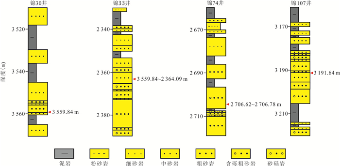
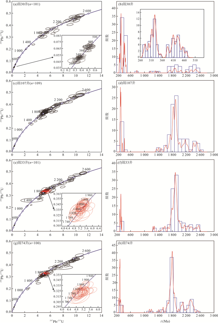
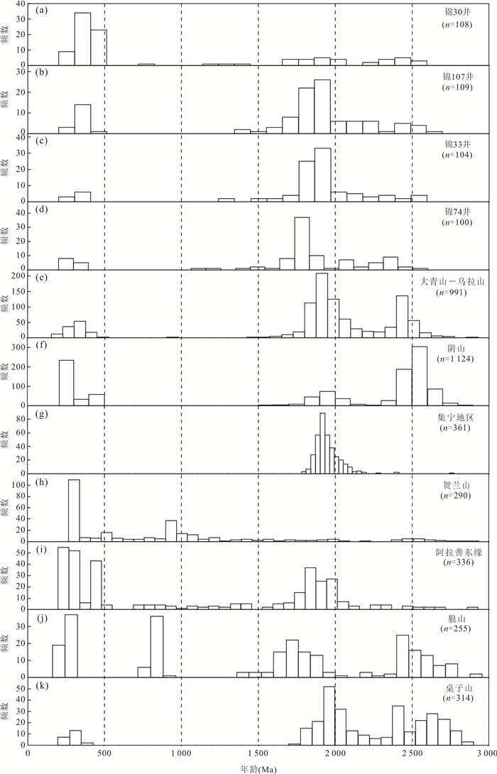
The detrital mineral contents, debris types and heavy mineral assemblages of Upper Paleozoic sandstone are obviously different from the east to west in the northern Ordos Basin. However, the provenance of sandstone still remains unclear. The distribution and variation characteristics of detrital zircon ages were studied using LA-ICP-MS dating of the detrital zircons from sandstones of Lower Shihezi Formation in the Hangjinqi area, Ordos Basin. The source of detrital zircons of different age components is identified, and difference of provenance system is analyzed. The main conclusions can be drawn as follows. Detrital mineral content of Lower Shihezi Formation is different in different regions, with quartz content decreasing and lithic fragment content increasing from west to east. Detrital zircons of Lower Shihezi Formation yield four peak ages of 280-340 Ma, 400-450 Ma, 1 700-2 000 Ma, and 2 200-2 500 Ma, and the proportion of Phanerozoic age of zircons gradually increases from east to west, with zircons having age range from 400 Ma to 450 Ma only appearing in the western and middle regions. By comparing the isotopic ages for the plutons in and around research areas, the sandstone of Lower Shihezi Formation in the western region mainly sourced from Alxa Block while in the middle and eastern regions mainly sourced from Daqingshan-Wulashan, Yinshan and Jining areas, and the provenance of middle region was also affected by Alax Block. Based on the difference of zircon ages, detrital mineral content and rock fragment component of Lower Shihezi Formation, it is believed that multiple provenance systems exist, which can be divided into western provenance, middle mixture provenance and northeast provenance in the Hangjinqi area.
The detrital mineral contents, debris types and heavy mineral assemblages of Upper Paleozoic sandstone are obviously different from the east to west in the northern Ordos Basin. However, the provenance of sandstone still remains unclear. The distribution and variation characteristics of detrital zircon ages were studied using LA-ICP-MS dating of the detrital zircons from sandstones of Lower Shihezi Formation in the Hangjinqi area, Ordos Basin. The source of detrital zircons of different age components is identified, and difference of provenance system is analyzed. The main conclusions can be drawn as follows. Detrital mineral content of Lower Shihezi Formation is different in different regions, with quartz content decreasing and lithic fragment content increasing from west to east. Detrital zircons of Lower Shihezi Formation yield four peak ages of 280-340 Ma, 400-450 Ma, 1 700-2 000 Ma, and 2 200-2 500 Ma, and the proportion of Phanerozoic age of zircons gradually increases from east to west, with zircons having age range from 400 Ma to 450 Ma only appearing in the western and middle regions. By comparing the isotopic ages for the plutons in and around research areas, the sandstone of Lower Shihezi Formation in the western region mainly sourced from Alxa Block while in the middle and eastern regions mainly sourced from Daqingshan-Wulashan, Yinshan and Jining areas, and the provenance of middle region was also affected by Alax Block. Based on the difference of zircon ages, detrital mineral content and rock fragment component of Lower Shihezi Formation, it is believed that multiple provenance systems exist, which can be divided into western provenance, middle mixture provenance and northeast provenance in the Hangjinqi area.


2021, 46(2): 555-571.
doi: 10.3799/dqkx.2020.081
Abstract:
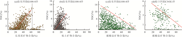
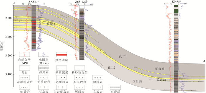
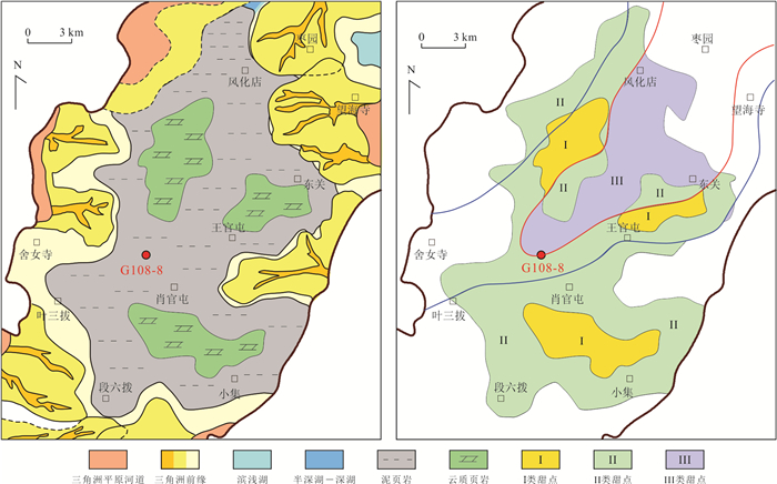
Both terrestrial tight oil and shale oil belong to low-porosity and low-permeability oil and gas reservoirs. They have great similarities and often have symbiotic relationships. However, their accumulation mechanism and dessert evaluation methods are quite different. In this paper, it uses systematic coring, logging and various tests and analysis data to synthesize the previous research results, and comprehensively discusses the differences between tight oil and shale oil accumulation conditions and enrichment rules, and further discusses the difference exploration directions between tight oil and shale oil. Studies indicate lithology differences. The types of tight oil and gas reservoirs are diverse, including tight sandstones, dense carbonate rocks, dense igneous rocks, etc.; shale oil and gas is mainly composed of fine-grained sediment rocks, which is reflected in the diversity of mineral components and is divided into carbonate shale, and can be divided into felsic shale, clay shale, mixed shale, etc.. In addition, property differences are also found. Both belong to tight reservoirs, which mainly develop intergranular pores, intercrystalline pores, dissolved pores, cracks, etc., mostly in micron pores. Shale oil reservoir is dominated by the original tight reservoir which is characterized by the development of organic pores, intergranular pores, interlayer cracks, etc., mostly based on nano-scale pores. Furthermore, accumulation condition differences are disclosed in the study. Both oil and gas sources are closely related to high-quality source rock, tight oil and gas reservoirs themselves do not produce hydrocarbons, the crude oil relies on the source-storage pressure difference caused by the kerogenization of organic-rich mud shale, and undergoes short-distance migration, compared with charging, the source and storage pressure difference is high, and the filling degree is high; shale oil itself is the oil-bearing layer system, which is the oil and gas that has been generated, has not been discharged, and is retained in the shale pores or cracks. Lastly, brittleness differences are revealed in the study, tight oil reservoir has good brittleness, shale brittleness is different due to the different composition, which is the key factor for the evaluation of shale oil dessert. Exploration constituency, tight oil dominant reservoir facies belt, high-quality source rock and the matching relationship between them are favorable for dense oil enrichment area, "sandwich" interlayer is the most favorable type; shale oil is controlled by the rock mature and rich in organic matter, and rock of brittle facies, which emphasizes the search for shale oil with higher brittleness in the enriched hydrocarbons.
Both terrestrial tight oil and shale oil belong to low-porosity and low-permeability oil and gas reservoirs. They have great similarities and often have symbiotic relationships. However, their accumulation mechanism and dessert evaluation methods are quite different. In this paper, it uses systematic coring, logging and various tests and analysis data to synthesize the previous research results, and comprehensively discusses the differences between tight oil and shale oil accumulation conditions and enrichment rules, and further discusses the difference exploration directions between tight oil and shale oil. Studies indicate lithology differences. The types of tight oil and gas reservoirs are diverse, including tight sandstones, dense carbonate rocks, dense igneous rocks, etc.; shale oil and gas is mainly composed of fine-grained sediment rocks, which is reflected in the diversity of mineral components and is divided into carbonate shale, and can be divided into felsic shale, clay shale, mixed shale, etc.. In addition, property differences are also found. Both belong to tight reservoirs, which mainly develop intergranular pores, intercrystalline pores, dissolved pores, cracks, etc., mostly in micron pores. Shale oil reservoir is dominated by the original tight reservoir which is characterized by the development of organic pores, intergranular pores, interlayer cracks, etc., mostly based on nano-scale pores. Furthermore, accumulation condition differences are disclosed in the study. Both oil and gas sources are closely related to high-quality source rock, tight oil and gas reservoirs themselves do not produce hydrocarbons, the crude oil relies on the source-storage pressure difference caused by the kerogenization of organic-rich mud shale, and undergoes short-distance migration, compared with charging, the source and storage pressure difference is high, and the filling degree is high; shale oil itself is the oil-bearing layer system, which is the oil and gas that has been generated, has not been discharged, and is retained in the shale pores or cracks. Lastly, brittleness differences are revealed in the study, tight oil reservoir has good brittleness, shale brittleness is different due to the different composition, which is the key factor for the evaluation of shale oil dessert. Exploration constituency, tight oil dominant reservoir facies belt, high-quality source rock and the matching relationship between them are favorable for dense oil enrichment area, "sandwich" interlayer is the most favorable type; shale oil is controlled by the rock mature and rich in organic matter, and rock of brittle facies, which emphasizes the search for shale oil with higher brittleness in the enriched hydrocarbons.


2021, 46(2): 572-582.
doi: 10.3799/dqkx.2020.049
Abstract:
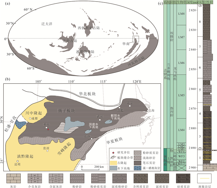
The Wufeng-Longmaxi black shales were widely developed in the Yangtze region which was located in low latitude area during the Late Ordovician-Early Silurian. This marine shale succession is one of the most important hydrocarbon source rocks in South China and has attracted wide attention for shale gas exploration and development in China, which has been the focus for shale gas exploration. However, little is known about the synthetical factors controlling enrichment of organic matter and the relationships between them. In this study, it studies Well 143-5 in Wulong area of Southeast Chongqing to analyze the stratigraphic characteristics and paleomarine environments of the Wufeng-Lower Longmaxi shales, it discusses the paleo-climate evolution, volcanic activity, paleoproductivity, redox conditions and their relationships with organic matter enrichment. The results reveal that there are strong positive correlations between TOC content and strong volcanism, anoxic environment, high paleoproductivity, and warm paleoclimate. Due to strong volcanism and chemical weathering, nutrient content in the ocean was improved greatly, prompting the flourishing of animals and high productivity. At the same time, the marine environments became anoxic or euxinic, and rich in silicon. These paleoceanographic environments provided excellent conditions for organic matter enrichment.
The Wufeng-Longmaxi black shales were widely developed in the Yangtze region which was located in low latitude area during the Late Ordovician-Early Silurian. This marine shale succession is one of the most important hydrocarbon source rocks in South China and has attracted wide attention for shale gas exploration and development in China, which has been the focus for shale gas exploration. However, little is known about the synthetical factors controlling enrichment of organic matter and the relationships between them. In this study, it studies Well 143-5 in Wulong area of Southeast Chongqing to analyze the stratigraphic characteristics and paleomarine environments of the Wufeng-Lower Longmaxi shales, it discusses the paleo-climate evolution, volcanic activity, paleoproductivity, redox conditions and their relationships with organic matter enrichment. The results reveal that there are strong positive correlations between TOC content and strong volcanism, anoxic environment, high paleoproductivity, and warm paleoclimate. Due to strong volcanism and chemical weathering, nutrient content in the ocean was improved greatly, prompting the flourishing of animals and high productivity. At the same time, the marine environments became anoxic or euxinic, and rich in silicon. These paleoceanographic environments provided excellent conditions for organic matter enrichment.


2021, 46(2): 583-599.
doi: 10.3799/dqkx.2020.026
Abstract:
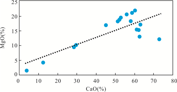
The origin of dolomite in Tongzi Formation of Lower Ordovician in Sichuan Basin has been studied less, and there are various models, and no consensus has been reached. Through the system's core observation, thin slice identification, geochemical analysis and other methods, dolomite-related rock types such as dolomite, granular dolomite and quartz dolomite and dolomitic quartz sandstone are identified in the Tongzi Formation of the Sichuan Basin. Geochemical analysis reveals different geochemical characteristics and different dolomitization mechanisms of different types of dolomite. MgO and CaO values of grain dolomite show obvious positive correlation, with relatively high δ18OPDBvalue, δ13CPDB value, Sr value and higher Mg/Ca ratio, and lower Fe and Mn values, which is considered to be the cause of dolomite evaporation pump dolomitization. Class A containing quartz dolomite and dolomitic quartz sandstone has similar geochemical characteristics to grain dolomite, and also formed in the quasi-simultaneous period of dolomitization. The MgO and CaO contents of the granular dolomite show a weak negative correlation. The δ13CPDBvalue and the δ18OPDBvalue are basically consistent with the distribution range of seawater carbon and oxygen isotope values. The Sr content is relatively high, which is considered to be the cause of reflux infiltration of dolomitization. Class B containing quartz dolomite and dolomitic quartz sandstone develops only in the local area near the provenance, and the contents of MgO and CaO are positively correlated. The δ13CPDBvalue and the δ18OPDBvalue show a significant negative bias. Compared with other two types of dolomite, Class B has higher Al2O3, Fe, Mn contents and relatively lower Sr content, and are affected by the mixing of terrestrial debris. In summary, it is believed that it is the dolomitization of mixed water. The Tongzi Formation in the Sichuan Basin has coexistence characteristics of three types of dolomitization, and the mechanism of the Upper Cambrian dolomitization is inherited.
The origin of dolomite in Tongzi Formation of Lower Ordovician in Sichuan Basin has been studied less, and there are various models, and no consensus has been reached. Through the system's core observation, thin slice identification, geochemical analysis and other methods, dolomite-related rock types such as dolomite, granular dolomite and quartz dolomite and dolomitic quartz sandstone are identified in the Tongzi Formation of the Sichuan Basin. Geochemical analysis reveals different geochemical characteristics and different dolomitization mechanisms of different types of dolomite. MgO and CaO values of grain dolomite show obvious positive correlation, with relatively high δ18OPDBvalue, δ13CPDB value, Sr value and higher Mg/Ca ratio, and lower Fe and Mn values, which is considered to be the cause of dolomite evaporation pump dolomitization. Class A containing quartz dolomite and dolomitic quartz sandstone has similar geochemical characteristics to grain dolomite, and also formed in the quasi-simultaneous period of dolomitization. The MgO and CaO contents of the granular dolomite show a weak negative correlation. The δ13CPDBvalue and the δ18OPDBvalue are basically consistent with the distribution range of seawater carbon and oxygen isotope values. The Sr content is relatively high, which is considered to be the cause of reflux infiltration of dolomitization. Class B containing quartz dolomite and dolomitic quartz sandstone develops only in the local area near the provenance, and the contents of MgO and CaO are positively correlated. The δ13CPDBvalue and the δ18OPDBvalue show a significant negative bias. Compared with other two types of dolomite, Class B has higher Al2O3, Fe, Mn contents and relatively lower Sr content, and are affected by the mixing of terrestrial debris. In summary, it is believed that it is the dolomitization of mixed water. The Tongzi Formation in the Sichuan Basin has coexistence characteristics of three types of dolomitization, and the mechanism of the Upper Cambrian dolomitization is inherited.


2021, 46(2): 600-620.
doi: 10.3799/dqkx.2020.075
Abstract:
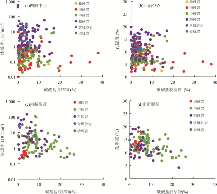
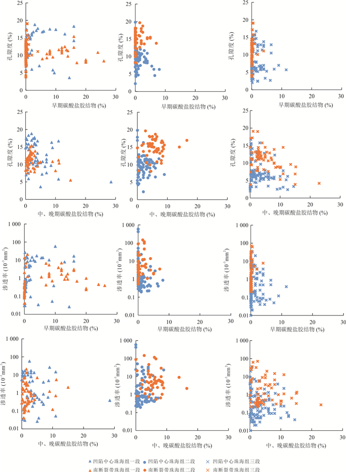
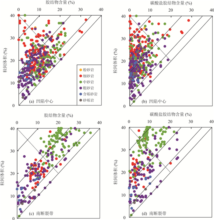
Carbonate cement is the most common cement type found in the pore space of sandstone. By clarifying the development characteristics,the period and distribution of carbonate cement,the influence mechanisms of carbonate cement on reservoir quality can be quantitatively determined. In this study,the Zhuhai Formation in the Wenchang A Depression was divided into two main sedimentary areas,namely the center of the depression and the area near the Zhu III fault zone. The type,content,occurrence state,stage and distribution characteristics of carbonate cement in the marine-continental transitional sandstone reservoirs of two main areas were analyzed systemically based on core observation,thin sections,cathodoluminescence analysis and carbon and oxygen isotopes respectively. The effect of carbonate cementation on reservoir quality was quantitatively analyzed. Results show that carbonate cements in the Zhuhai Formation have typical characteristics of multiple types and multiple stages. The distribution characteristics of carbonate cement show obvious vertical and plane regularity. The porosity reduced by carbonate cementation accounts for 9.7%-43.0% with an average of 20.7%,accounting for 33.6%-88.2% with an average of 60.6% of the total porosity reduced by cementation. Carbonate cement has a greater effect on the porosity of coarse-grained lithology. Influenced by the distribution of fault zone and thermal fluid activity,compared with the center of depression,the well area near the south fault zone developed more carbonate cement. The area with weak carbonate cementation in the center of the depression,or the well area far away from the South fault zone,can be used as a favorable area to find the "sweet spots" reservoir under the low permeability background in the Wenchang A Depression.
Carbonate cement is the most common cement type found in the pore space of sandstone. By clarifying the development characteristics,the period and distribution of carbonate cement,the influence mechanisms of carbonate cement on reservoir quality can be quantitatively determined. In this study,the Zhuhai Formation in the Wenchang A Depression was divided into two main sedimentary areas,namely the center of the depression and the area near the Zhu III fault zone. The type,content,occurrence state,stage and distribution characteristics of carbonate cement in the marine-continental transitional sandstone reservoirs of two main areas were analyzed systemically based on core observation,thin sections,cathodoluminescence analysis and carbon and oxygen isotopes respectively. The effect of carbonate cementation on reservoir quality was quantitatively analyzed. Results show that carbonate cements in the Zhuhai Formation have typical characteristics of multiple types and multiple stages. The distribution characteristics of carbonate cement show obvious vertical and plane regularity. The porosity reduced by carbonate cementation accounts for 9.7%-43.0% with an average of 20.7%,accounting for 33.6%-88.2% with an average of 60.6% of the total porosity reduced by cementation. Carbonate cement has a greater effect on the porosity of coarse-grained lithology. Influenced by the distribution of fault zone and thermal fluid activity,compared with the center of depression,the well area near the south fault zone developed more carbonate cement. The area with weak carbonate cementation in the center of the depression,or the well area far away from the South fault zone,can be used as a favorable area to find the "sweet spots" reservoir under the low permeability background in the Wenchang A Depression.


2021, 46(2): 621-631.
doi: 10.3799/dqkx.2020.069
Abstract:
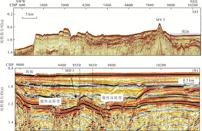
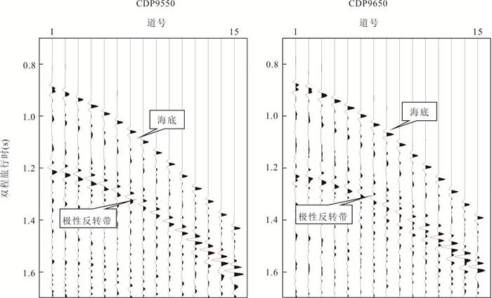
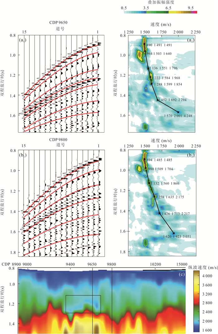
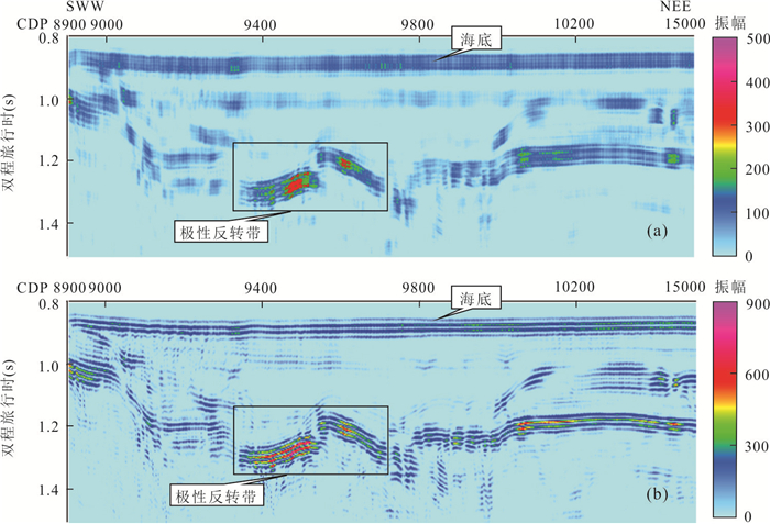
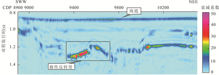
In recent years,a number of methane-venting mud volcanoes have been found in the southwest area of the Dongsha waters from multi-channel seismic,sub-bottom profiling and dredging survey. Studying mud volcanoes has great significance for oil and gas reserves. In this paper,a buried anticline was found near a mud volcano,MV3,with reversed polarity on a multi-channel seismic profile,where the absolute amplitude increases with offset. To detect whether it contains natural gas,velocity analysis,AVO inversion and frequency absorption attenuation analysis were carried out. There is a low P-wave velocity layer under the reflector of reversed polarity. AVO inversion shows that the polarity reversal zone features negative values in intercept and gradient sections,and falls in the third quadrant in P and G cross-plot. The polarity reversal zone features positive in S-wave reflectivity section,and is highly negative in Poisson ratio change rate section. Frequency absorption and attenuation analysis shows rapid energy loss of high frequency and relative increase of low frequency. Multiple attributes point to gas accumulation there,likely associated with the methane seepage from deep.
In recent years,a number of methane-venting mud volcanoes have been found in the southwest area of the Dongsha waters from multi-channel seismic,sub-bottom profiling and dredging survey. Studying mud volcanoes has great significance for oil and gas reserves. In this paper,a buried anticline was found near a mud volcano,MV3,with reversed polarity on a multi-channel seismic profile,where the absolute amplitude increases with offset. To detect whether it contains natural gas,velocity analysis,AVO inversion and frequency absorption attenuation analysis were carried out. There is a low P-wave velocity layer under the reflector of reversed polarity. AVO inversion shows that the polarity reversal zone features negative values in intercept and gradient sections,and falls in the third quadrant in P and G cross-plot. The polarity reversal zone features positive in S-wave reflectivity section,and is highly negative in Poisson ratio change rate section. Frequency absorption and attenuation analysis shows rapid energy loss of high frequency and relative increase of low frequency. Multiple attributes point to gas accumulation there,likely associated with the methane seepage from deep.


2021, 46(2): 632-641.
doi: 10.3799/dqkx.2020.029
Abstract:
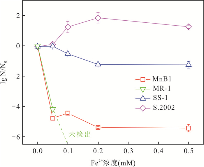
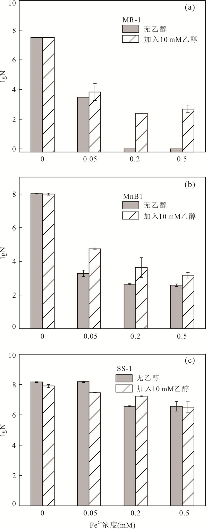
Geologic microorganisms are the main factors driving the redox cycling of iron and manganese in sedimentary environment. The effect and mechanism of Fe(II) oxygenation on the activities of different iron and manganese cycling functional microbes remain unexplored. In this study,it used Shewanella oneidensis MR-1,Pseudogulbenkiania sp. strain 2002,Pseudomonas putida MnB1,Leptothrix discophora SS-1 as the representative iron and manganese cycling functional microbes,it investigated the difference in effect and mechanisms of Fe(II) oxygenation on the activities of these four bacteria. Results show that the living cell counts of MR-1 and MnB1 decreased by 4-5 lg upon 60 min oxygenation of 0.05 mM Fe(II),but no significant inactivation of SS-1 and S.2002 was observed. The surface absorbed •OH and intracellular •OH produced from Fe(II) oxygenation were the dominant reasons for bacteria inactivation,the extracellular H2O2,extracellular dissolved •OH and Fe(III) oxides are minor causes for bacteria inactivation. SS-1 and S.2002 show oxidative stress responses during Fe2+ oxygenation,which helped to resist the damage of reactive oxygen species.
Geologic microorganisms are the main factors driving the redox cycling of iron and manganese in sedimentary environment. The effect and mechanism of Fe(II) oxygenation on the activities of different iron and manganese cycling functional microbes remain unexplored. In this study,it used Shewanella oneidensis MR-1,Pseudogulbenkiania sp. strain 2002,Pseudomonas putida MnB1,Leptothrix discophora SS-1 as the representative iron and manganese cycling functional microbes,it investigated the difference in effect and mechanisms of Fe(II) oxygenation on the activities of these four bacteria. Results show that the living cell counts of MR-1 and MnB1 decreased by 4-5 lg upon 60 min oxygenation of 0.05 mM Fe(II),but no significant inactivation of SS-1 and S.2002 was observed. The surface absorbed •OH and intracellular •OH produced from Fe(II) oxygenation were the dominant reasons for bacteria inactivation,the extracellular H2O2,extracellular dissolved •OH and Fe(III) oxides are minor causes for bacteria inactivation. SS-1 and S.2002 show oxidative stress responses during Fe2+ oxygenation,which helped to resist the damage of reactive oxygen species.


2021, 46(2): 642-651.
doi: 10.3799/dqkx.2020.054
Abstract:
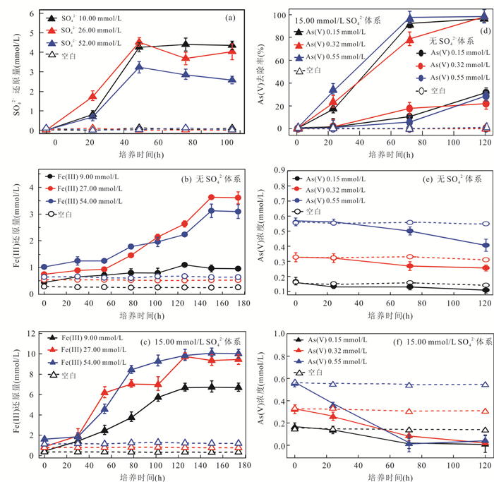
Sulfur plays an important role in the biogeochemical cycle of iron and arsenic. But the effect of S(0),an intermediate product of the sulfur cycle in groundwater systems,on biotransformation of iron and arsenic remains unexplored. Laboratory simulation experiments were conducted to investigate the reduction of Fe(III) and As(V) in the liquid phase and arsenic-bearing goethite by bacteria D2201 with sulfur. The results show that 74% of Fe(III) in the liquid phase were reduced by the strain D2201 with strong iron-reducing potential. When sulfur was added,S(-II) from the bacteria reducing S(0) increased the iron reduction rate to 94%. However,the bacterial reduction of arsenic was not accelerated significantly by added sulfur. Fe(III) in arsenic-bearing goethite was reduced rapidly by the strain D2201 at the beginning of the experiment. In the experiment,32.12 μmol/L Fe(II) was released in the liquid phase. The added sulfur enhanced the bacterial reduction of arsenic-bearing goethite,and the released Fe(II) increased to 284.13 μmol/L. At the same time,the concentration of arsenic released into solution increased 1.6 times. The results indicate that sulfur significantly promoted the bacterial reduction and dissolution of arsenic-bearing goethite and accelerated the release of arsenic. It was shown by XRD and SEM-EDS that the mineral phase of iron mineral reduced by the strain D2201 was not changed. Under the condition of sulfur,the mineral only has a certain degree of agglomeration,not transform to other minerals. And arsenic was not adsorbed by the mineral once again.
Sulfur plays an important role in the biogeochemical cycle of iron and arsenic. But the effect of S(0),an intermediate product of the sulfur cycle in groundwater systems,on biotransformation of iron and arsenic remains unexplored. Laboratory simulation experiments were conducted to investigate the reduction of Fe(III) and As(V) in the liquid phase and arsenic-bearing goethite by bacteria D2201 with sulfur. The results show that 74% of Fe(III) in the liquid phase were reduced by the strain D2201 with strong iron-reducing potential. When sulfur was added,S(-II) from the bacteria reducing S(0) increased the iron reduction rate to 94%. However,the bacterial reduction of arsenic was not accelerated significantly by added sulfur. Fe(III) in arsenic-bearing goethite was reduced rapidly by the strain D2201 at the beginning of the experiment. In the experiment,32.12 μmol/L Fe(II) was released in the liquid phase. The added sulfur enhanced the bacterial reduction of arsenic-bearing goethite,and the released Fe(II) increased to 284.13 μmol/L. At the same time,the concentration of arsenic released into solution increased 1.6 times. The results indicate that sulfur significantly promoted the bacterial reduction and dissolution of arsenic-bearing goethite and accelerated the release of arsenic. It was shown by XRD and SEM-EDS that the mineral phase of iron mineral reduced by the strain D2201 was not changed. Under the condition of sulfur,the mineral only has a certain degree of agglomeration,not transform to other minerals. And arsenic was not adsorbed by the mineral once again.


2021, 46(2): 652-660.
doi: 10.3799/dqkx.2020.063
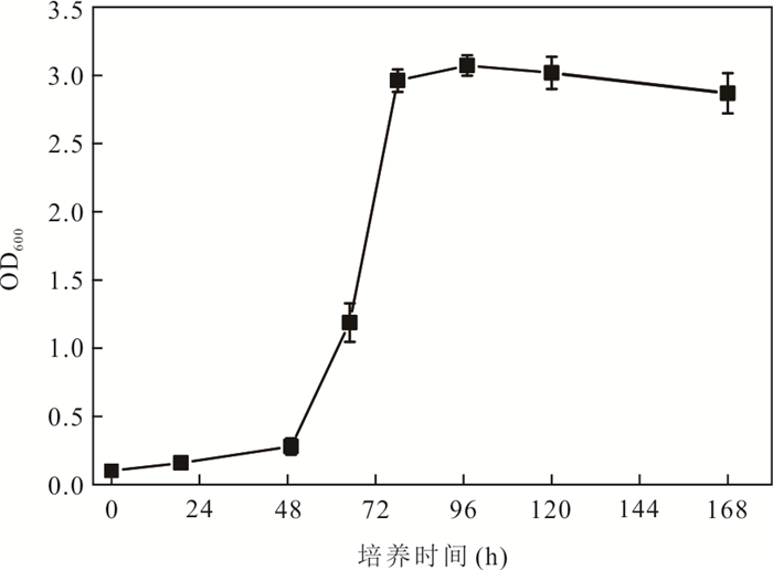
Abstract:
Sulfate reducing bacteria (SRB) are important anaerobic microorganisms,which are actively involved in arsenic transformation. However,the effect of the biogeochemical cycle mediated by sulfate reducing bacteria on the migration and transformation of arsenic adsorbed on the surface of iron oxide is urgently needed to be further studied. In this study,a sulfate reducing bacterium,strain Desulfovibrio JH-1 was isolated from the aquifer sediments in typical arsenic affected region of Jianghan Plain. Its sulfate,arsenate and ferric iron reduction capacity was identified,and furtherly a microcosm experiment was carried out to determine its role on the mineral-phase transformation of As-bearing ferrihydrite and As mobilization. Results indicate that it possesses the capacity of iron reduction,Fe(III) can be reduced regardless of the presence of sulfate in the system,the amount of iron reduction increases significantly under the sufficient sulfate environment. However,it doesn't possess the capacity of arsenate reduction,the removal rate of As(V) in the culture system with added sulfate could reach up to 96%. In addition,JH-S1 can promote the reduction and release of iron and arsenic from the As-bearing ferrihydrite by bacterially generated HS-,and promote the transformation of ferrihydrite to lepidocrocite. The present results provide new insights for the important role of indigenous sulfate reducing bacteria in the coupled Fe-S-As cycling in shallow aquifer system of the Jianghan Plain.
Sulfate reducing bacteria (SRB) are important anaerobic microorganisms,which are actively involved in arsenic transformation. However,the effect of the biogeochemical cycle mediated by sulfate reducing bacteria on the migration and transformation of arsenic adsorbed on the surface of iron oxide is urgently needed to be further studied. In this study,a sulfate reducing bacterium,strain Desulfovibrio JH-1 was isolated from the aquifer sediments in typical arsenic affected region of Jianghan Plain. Its sulfate,arsenate and ferric iron reduction capacity was identified,and furtherly a microcosm experiment was carried out to determine its role on the mineral-phase transformation of As-bearing ferrihydrite and As mobilization. Results indicate that it possesses the capacity of iron reduction,Fe(III) can be reduced regardless of the presence of sulfate in the system,the amount of iron reduction increases significantly under the sufficient sulfate environment. However,it doesn't possess the capacity of arsenate reduction,the removal rate of As(V) in the culture system with added sulfate could reach up to 96%. In addition,JH-S1 can promote the reduction and release of iron and arsenic from the As-bearing ferrihydrite by bacterially generated HS-,and promote the transformation of ferrihydrite to lepidocrocite. The present results provide new insights for the important role of indigenous sulfate reducing bacteria in the coupled Fe-S-As cycling in shallow aquifer system of the Jianghan Plain.


2021, 46(2): 661-670.
doi: 10.3799/dqkx.2020.025
Abstract:
Chenhu wetland is a typical freshwater lake-type wetland in the Middle-Lower Yangtze Plain, and has severely degraded since 1960s. In this study, aerial photographs or remote sensing images captured at eight different stages (i.e. 1964, 1975, 1987, 1997, 1998, 2007, 2016 and 2018) were analyzed to reveal the degradation processes and mechanisms of the Chenhu wetland in Wuhan over the past 50 years by the aid of remote sensing, dynamic degree models and transition matrix models.Our investigation reveals that the Chenhu wetland was gradually altered to fish ponds or agricultural lands from north to south, shrunk up to 77% in total between 1964 and 2018. Degradation of the Chenhu wetland by human impacts during this period can be divided into three stages: (i) between 1964 and 1975, degradation was dominated by filling of lakes into agricultural lands, with the rate of agricultural lands expansion exceeding 141%; (ii) between 1975 and 1994, artificial lake reconstruction projects has altered large areas of lakes into marshes; (iii) between 1997 and 2018, new marshes altered from lakes were further cultivated into agricultural lands or reserved as fish ponds. In general, population expansion and changes in land use policies have caused the degradation of ecosystem services, including impaired capacity in flood regulation and storage, natural self-purification and biodiversity losses. The degradation modes uncovered for the Chenhu wetland can also shed light on similar investigations on the degradation of other lake-type wetlands in Middle-Lower Yangtze Plain and even the whole China.
Chenhu wetland is a typical freshwater lake-type wetland in the Middle-Lower Yangtze Plain, and has severely degraded since 1960s. In this study, aerial photographs or remote sensing images captured at eight different stages (i.e. 1964, 1975, 1987, 1997, 1998, 2007, 2016 and 2018) were analyzed to reveal the degradation processes and mechanisms of the Chenhu wetland in Wuhan over the past 50 years by the aid of remote sensing, dynamic degree models and transition matrix models.Our investigation reveals that the Chenhu wetland was gradually altered to fish ponds or agricultural lands from north to south, shrunk up to 77% in total between 1964 and 2018. Degradation of the Chenhu wetland by human impacts during this period can be divided into three stages: (i) between 1964 and 1975, degradation was dominated by filling of lakes into agricultural lands, with the rate of agricultural lands expansion exceeding 141%; (ii) between 1975 and 1994, artificial lake reconstruction projects has altered large areas of lakes into marshes; (iii) between 1997 and 2018, new marshes altered from lakes were further cultivated into agricultural lands or reserved as fish ponds. In general, population expansion and changes in land use policies have caused the degradation of ecosystem services, including impaired capacity in flood regulation and storage, natural self-purification and biodiversity losses. The degradation modes uncovered for the Chenhu wetland can also shed light on similar investigations on the degradation of other lake-type wetlands in Middle-Lower Yangtze Plain and even the whole China.


2021, 46(2): 671-682.
doi: 10.3799/dqkx.2020.039
Abstract:
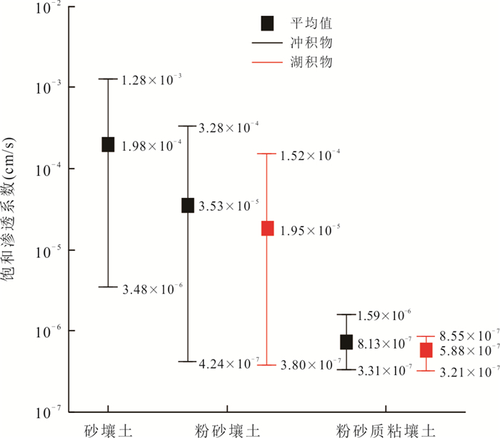
At present,there is no deep understanding of the mechanism that affects the law of soil saturated hydraulic conductivity. The shallow soils in the lower reaches of Hanjiang River in Jianghan Plain from different sedimentary environment,lithologies and land use were sampled to carry out the variable head Darcy experiment by improved soil permeation instrument (TST-55).The results show that the mean soil saturated hydraulic conductivity is 4.94×10⁻⁵cm/s with log-normal distribution. In silty loam,the mean value of soil saturated hydraulic conductivity for alluvium and lacustrine deposits are 3.53×10⁻⁵cm/s and 1.98×10⁻⁵cm/s respectively,and the mean value for them is 8.13×10⁻⁷cm/s and 5.88×10⁻⁷cm/s in silty clay loam. For the same lithology,soil saturated hydraulic conductivity of alluvial sediments is obviously larger than that of lacustrine sediment. The average soil saturated hydraulic conductivity of sandy loam,silty loam and silty clay loam from high to low are 1.98×10⁻⁵cm/s,3.53×10-5cm/s and 8.13×10⁻⁷cm/s,respectively. The mean soil saturated hydraulic conductivities of silty loam and silty clay loam in cultivated soil are 3.75×10⁻⁵cm/s and 8.11×10⁻⁷cm/s,while the mean value of them are 1.88×10⁻⁶cm/s and 5.93×10⁻⁷cm/s in non-cultivated soil. The soil saturated hydraulic conductivity of cultivated soils is also higher than that of non-cultivated soils.
At present,there is no deep understanding of the mechanism that affects the law of soil saturated hydraulic conductivity. The shallow soils in the lower reaches of Hanjiang River in Jianghan Plain from different sedimentary environment,lithologies and land use were sampled to carry out the variable head Darcy experiment by improved soil permeation instrument (TST-55).The results show that the mean soil saturated hydraulic conductivity is 4.94×10⁻⁵cm/s with log-normal distribution. In silty loam,the mean value of soil saturated hydraulic conductivity for alluvium and lacustrine deposits are 3.53×10⁻⁵cm/s and 1.98×10⁻⁵cm/s respectively,and the mean value for them is 8.13×10⁻⁷cm/s and 5.88×10⁻⁷cm/s in silty clay loam. For the same lithology,soil saturated hydraulic conductivity of alluvial sediments is obviously larger than that of lacustrine sediment. The average soil saturated hydraulic conductivity of sandy loam,silty loam and silty clay loam from high to low are 1.98×10⁻⁵cm/s,3.53×10-5cm/s and 8.13×10⁻⁷cm/s,respectively. The mean soil saturated hydraulic conductivities of silty loam and silty clay loam in cultivated soil are 3.75×10⁻⁵cm/s and 8.11×10⁻⁷cm/s,while the mean value of them are 1.88×10⁻⁶cm/s and 5.93×10⁻⁷cm/s in non-cultivated soil. The soil saturated hydraulic conductivity of cultivated soils is also higher than that of non-cultivated soils.


2021, 46(2): 683-696.
doi: 10.3799/dqkx.2020.082
Abstract:
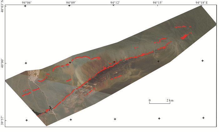
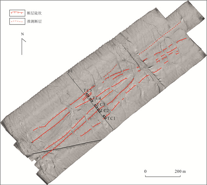
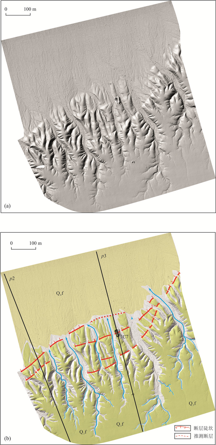
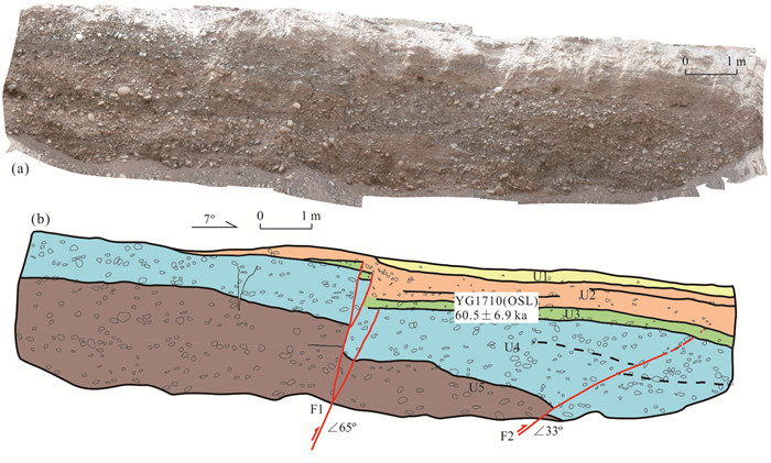
The Yangguan Fault is located on northwestern section of the Altyn Tagh Fault, which is a large strike slip fault and seismotectonic in Northeast Tibet Plateau, which poses potential seismic hazard to city development and culture relics in Dunhuang area. In this study it focuses on characterizing activity of the Yangguan Fault, using high resolution satellite imagery to map faults in space. At two study sites, it made detailed investigation by methods of difference GPS, aerial photogrammetry with unmanned aerial vehicle, paleoseismical trench and Optically Stimulated Luminescence dating. The preliminary results are that the Yangguan Fault is a thrust fault trending NEE with high dipping angle; its latest event likely occurred between 43.5 ka and 12.1 ka. The results imply that the eastern section of the Yangguan Fault ruptured at least during Late Pleistocene. It is proposed that the eastern section rupture will cause an earthquake of Mw 6.6, shaking the nearby area strongly, and the seismic intensity in the Dunhuang downtown will be more than Ⅵ, reaching up to Ⅸ at Yangguan relic site. Therefore, the Yangguan Fault is an important seismic fault in West Hexi Corridor. This study provides critical data for seismic prevention and disaster mitigation for city development and culture relic protection in Dunhuang area.
The Yangguan Fault is located on northwestern section of the Altyn Tagh Fault, which is a large strike slip fault and seismotectonic in Northeast Tibet Plateau, which poses potential seismic hazard to city development and culture relics in Dunhuang area. In this study it focuses on characterizing activity of the Yangguan Fault, using high resolution satellite imagery to map faults in space. At two study sites, it made detailed investigation by methods of difference GPS, aerial photogrammetry with unmanned aerial vehicle, paleoseismical trench and Optically Stimulated Luminescence dating. The preliminary results are that the Yangguan Fault is a thrust fault trending NEE with high dipping angle; its latest event likely occurred between 43.5 ka and 12.1 ka. The results imply that the eastern section of the Yangguan Fault ruptured at least during Late Pleistocene. It is proposed that the eastern section rupture will cause an earthquake of Mw 6.6, shaking the nearby area strongly, and the seismic intensity in the Dunhuang downtown will be more than Ⅵ, reaching up to Ⅸ at Yangguan relic site. Therefore, the Yangguan Fault is an important seismic fault in West Hexi Corridor. This study provides critical data for seismic prevention and disaster mitigation for city development and culture relic protection in Dunhuang area.


2021, 46(2): 697-707.
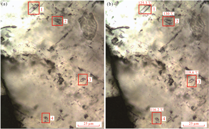
doi: 10.3799/dqkx.2020.058
Abstract:
Aiming at the shortcomings of the calculation assumptions proposed in the existing slope progressive failure analysis model considering the effect of strain-softening, the Zhaoshuling landslide in the Three Gorges Reservoir area is taken as the research object, and the influence of groundwater level fluctuations and seismic forces is considered to propose the progressive failure mode and stability reliability analysis method of strain-softening slope under multi-field coupling conditions.The results show that the groundwater level fluctuation and seismic force would affect the progressive failure mode and failure probability of the landslide to various degrees.The landslide was stable at 145 m, 175 m water level and the steeply reduced reservoir water level from 175 m to 145 m, but it had a local progressive failure probability with 14.119%, 20.266% and 21.797% respectively. And the landslide had a total progressive failure probability with 34.067%, 38.061% and 38.405% respectively under the action of seismic force with intensity VII, also three kinds of water storage conditions were considered. Moreover, according to the progressive failure mode of landslide, it is pointed out that the best reinforcement position should be at the front of Yanjiang Avenue. The analysis method is reliable and can provide a reference for the progressive failure mode and stability evaluation of slopes.
Aiming at the shortcomings of the calculation assumptions proposed in the existing slope progressive failure analysis model considering the effect of strain-softening, the Zhaoshuling landslide in the Three Gorges Reservoir area is taken as the research object, and the influence of groundwater level fluctuations and seismic forces is considered to propose the progressive failure mode and stability reliability analysis method of strain-softening slope under multi-field coupling conditions.The results show that the groundwater level fluctuation and seismic force would affect the progressive failure mode and failure probability of the landslide to various degrees.The landslide was stable at 145 m, 175 m water level and the steeply reduced reservoir water level from 175 m to 145 m, but it had a local progressive failure probability with 14.119%, 20.266% and 21.797% respectively. And the landslide had a total progressive failure probability with 34.067%, 38.061% and 38.405% respectively under the action of seismic force with intensity VII, also three kinds of water storage conditions were considered. Moreover, according to the progressive failure mode of landslide, it is pointed out that the best reinforcement position should be at the front of Yanjiang Avenue. The analysis method is reliable and can provide a reference for the progressive failure mode and stability evaluation of slopes.


2021, 46(2): 708-718.
doi: 10.3799/dqkx.2020.062
Abstract:
The Zhongjian Canyon is segmented, but the key geomorphic features of the segmentation, the sedimentary filling of each segment and its controlling factors lack detailed description and systematic demonstration. The integrated analysis of high-resolution 2D/3D seismic data and bathymetric data were used to study the geomorphology and sedimentary features of the Zhongjian Canyon, and the main controlling factors of the sedimentation process in both of the north and south segmentations of the Zhongjian Canyon are summarized. The Zhongjian Canyon extends in NW direction between the Guangle and Xisha uplifts, a knick point as the high point near the Huaguang reef separates the Zhongjian Canyon into southern and northern segmentations. The sedimentary system in the northern segmentation of the Zhongjian Canyon consists of gravity flow deposits (channels, sheets and slumps) and bottom current deposits (drifters, moats and troughs), and the northern segmentation is dominated by gravity channels and submarine fans. Sedimentary system of the northern segmentation is controlled by the interaction between bottom currents and gravity flows, of which the bottom currents came out in Middle Miocene, reworking the gravity channels, leading to migration of the axes or asymmetry wings; gravity flows became weakened while bottom currents strengthened after Pliocene, and sediment waves and drift bodies are widely developed. The channel in the southern segmentation of the canyon shows a depositional cycle of erosion-deposition-abandonment, and no bottom flow deposition was observed. The relative sea level changes, leading to the change of carbonate productivity, affect the provenance supply, so the highstand shedding of carbonate platform promotes the development of channel at high sea level.
The Zhongjian Canyon is segmented, but the key geomorphic features of the segmentation, the sedimentary filling of each segment and its controlling factors lack detailed description and systematic demonstration. The integrated analysis of high-resolution 2D/3D seismic data and bathymetric data were used to study the geomorphology and sedimentary features of the Zhongjian Canyon, and the main controlling factors of the sedimentation process in both of the north and south segmentations of the Zhongjian Canyon are summarized. The Zhongjian Canyon extends in NW direction between the Guangle and Xisha uplifts, a knick point as the high point near the Huaguang reef separates the Zhongjian Canyon into southern and northern segmentations. The sedimentary system in the northern segmentation of the Zhongjian Canyon consists of gravity flow deposits (channels, sheets and slumps) and bottom current deposits (drifters, moats and troughs), and the northern segmentation is dominated by gravity channels and submarine fans. Sedimentary system of the northern segmentation is controlled by the interaction between bottom currents and gravity flows, of which the bottom currents came out in Middle Miocene, reworking the gravity channels, leading to migration of the axes or asymmetry wings; gravity flows became weakened while bottom currents strengthened after Pliocene, and sediment waves and drift bodies are widely developed. The channel in the southern segmentation of the canyon shows a depositional cycle of erosion-deposition-abandonment, and no bottom flow deposition was observed. The relative sea level changes, leading to the change of carbonate productivity, affect the provenance supply, so the highstand shedding of carbonate platform promotes the development of channel at high sea level.


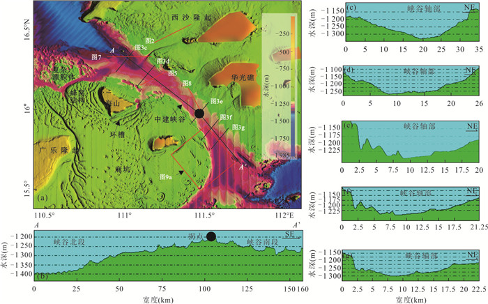
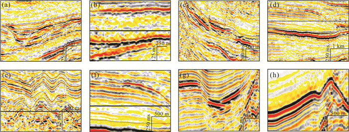
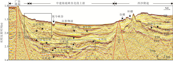


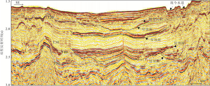
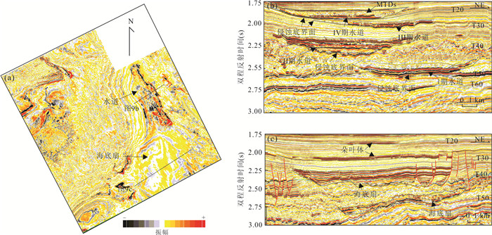
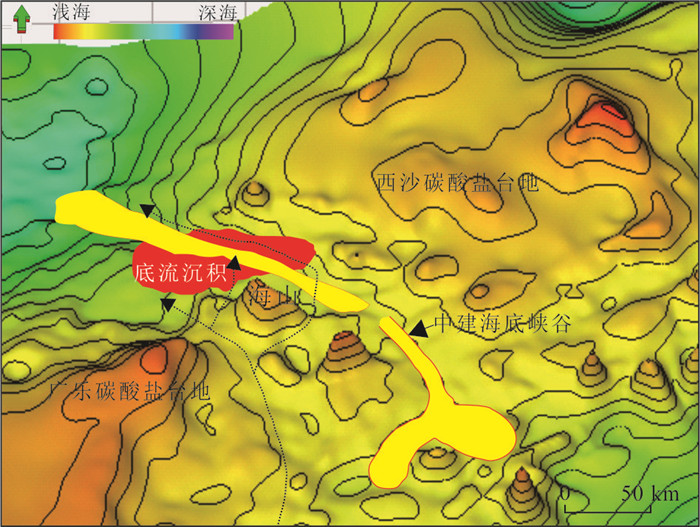
2021, 46(2): 719-728.
doi: 10.3799/dqkx.2020.051
Abstract:
Os isotopic stratigraphic dating method can be used to obtain the age frame of polymetallic crusts including growth discontinuities with high resolution, which has better development prospects than traditional dating methods. In comparison with the stratified Os isotopic composition curve of polymetallic crusts and the standard curve of sea water, we dated for the crusts and at the same time, the regional characteristics of the standard curve and its relationship with the material derived from earth crust and mantle were studied. Based on morphological fit, the growing stages of polymetallic crusts were 80-75 Ma, 70-65 Ma, 60-50 Ma, 42-40 Ma, 35-28 Ma, 15-10 Ma and 8-0 Ma. In central-western Pacific, the measured curve of Os isotopic composition of crusts in Magellan and Marshall seamounts fits well with the shapes and values of the standard curve, while that of crusts in Marcus-Wake and Line seamounts fits well in the trend but the values are respectively higher since 7 Ma and before 33 Ma. This phenomenon is related to the process during which the crust travelled in and out of the influence copes of prevailing westerlies and equatorial trade winds. The crust received the wind-transported dust materials from the Americas and Asia when it was in the wind belt, which makes the Os isotopic composition recorded by the crust go higher than the standard curve.
Os isotopic stratigraphic dating method can be used to obtain the age frame of polymetallic crusts including growth discontinuities with high resolution, which has better development prospects than traditional dating methods. In comparison with the stratified Os isotopic composition curve of polymetallic crusts and the standard curve of sea water, we dated for the crusts and at the same time, the regional characteristics of the standard curve and its relationship with the material derived from earth crust and mantle were studied. Based on morphological fit, the growing stages of polymetallic crusts were 80-75 Ma, 70-65 Ma, 60-50 Ma, 42-40 Ma, 35-28 Ma, 15-10 Ma and 8-0 Ma. In central-western Pacific, the measured curve of Os isotopic composition of crusts in Magellan and Marshall seamounts fits well with the shapes and values of the standard curve, while that of crusts in Marcus-Wake and Line seamounts fits well in the trend but the values are respectively higher since 7 Ma and before 33 Ma. This phenomenon is related to the process during which the crust travelled in and out of the influence copes of prevailing westerlies and equatorial trade winds. The crust received the wind-transported dust materials from the Americas and Asia when it was in the wind belt, which makes the Os isotopic composition recorded by the crust go higher than the standard curve.
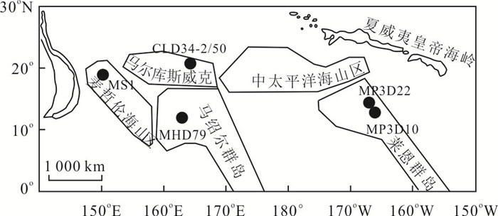


2021, 46(2): 729-742.
doi: 10.3799/dqkx.2019.959
Abstract:
To understand the mechanism of high-temperature hydrothermal system in highly permeable oceanic crust, a reactive hydrothermal convection model is proposed to solve mineral precipitation and its feedback on permeability. Mineral reaction of anhydrite, pyrite and chalcopyrite are accounted in the model. Precipitation and dissolution can be solved using solubility product of the mineral and transformed into permeability change. The results suggest that pyrite and chalcopyrite are precipitated as cap-like structure around 300-380℃ isotherm. With hydrothermal temperature increasing, the cap-like structure is moving to seafloor. Anhydrite is precipitated as chimney-like structure around focus flow by seawater heating and seawater-hydrothermal mixing. The low permeable chimney-like structure prevent seawater-hydrothermal mixing and thus keep hydrothermal at high temperature. Once the high-temperature focusing flow is formed, more metal can be dissolved in hydrothermal and be transported to shallow crust and seafloor. The numerical simulation results could help to understand the mechanism of high-temperature hydrothermal venting.
To understand the mechanism of high-temperature hydrothermal system in highly permeable oceanic crust, a reactive hydrothermal convection model is proposed to solve mineral precipitation and its feedback on permeability. Mineral reaction of anhydrite, pyrite and chalcopyrite are accounted in the model. Precipitation and dissolution can be solved using solubility product of the mineral and transformed into permeability change. The results suggest that pyrite and chalcopyrite are precipitated as cap-like structure around 300-380℃ isotherm. With hydrothermal temperature increasing, the cap-like structure is moving to seafloor. Anhydrite is precipitated as chimney-like structure around focus flow by seawater heating and seawater-hydrothermal mixing. The low permeable chimney-like structure prevent seawater-hydrothermal mixing and thus keep hydrothermal at high temperature. Once the high-temperature focusing flow is formed, more metal can be dissolved in hydrothermal and be transported to shallow crust and seafloor. The numerical simulation results could help to understand the mechanism of high-temperature hydrothermal venting.


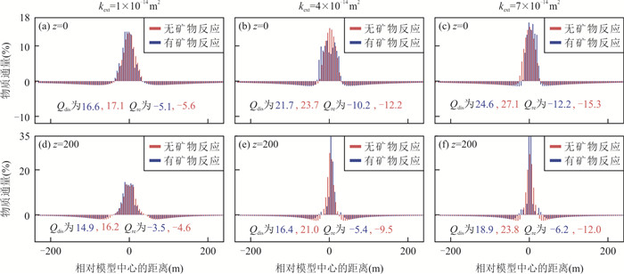


2021, 46(2): 743-758.
doi: 10.3799/dqkx.2020.042
Abstract:
Studing the abnormal mass change rate of Greenland ice sheet (GrIS) can help us understand the drivers of sea level change due to the abnormal climate events. Therefore, in this paper it focuses on the anomalous rate of GrIS mass change in 2010-2012 and its contributions to SLF and relative sea level (RSL) changes. By combining the 2003-2015 GRACE monthly gravity field data and surface mass balance (SMB) data, the spatio-temporal distributions of the mass change of the six extended sub-basins are estimated based on the mascon fitting and the grid scale factors. Afterwards, it obtains the spatial distribution of the SLF based on the sea level equation (SLE) and considering the self-attraction and loading effect. The results indicate that during 2003-2015, the total mass change rates of GrIS were -288±7 Gt/a and -275±1 Gt/a as derived from scaled GRACE and SMB results respectively; and the trend increased to -456±30 Gt/a and -464±38 Gt/a correspondingly during 2010-2012, when the northwest coast and the southeast coast showed a large number of melting. And the contributions of GrIS to sea level showed an inverted "V" type (i.e., first rise and then fall), while the global mean sea level change showed a distinct positive "V" type (i.e., first drop and then rise). Between 2003 and 2015, GrIS contributed approximately 31% of total terrestrial water reserves (converted to sea level rise), and a global average RSL increased by 0.07 cm/a, while the contribution to the RSL of Scandinavia and the Nordic region was -0.6 cm/a. In addition, the far-field RSL rising rate due to the melting of GrIS is nearly 30% higher than the global average. Meanwhile, in this paper it proves that the far-filed peak increase is less dependent on the accurate pattern of the self-attraction and loading.
Studing the abnormal mass change rate of Greenland ice sheet (GrIS) can help us understand the drivers of sea level change due to the abnormal climate events. Therefore, in this paper it focuses on the anomalous rate of GrIS mass change in 2010-2012 and its contributions to SLF and relative sea level (RSL) changes. By combining the 2003-2015 GRACE monthly gravity field data and surface mass balance (SMB) data, the spatio-temporal distributions of the mass change of the six extended sub-basins are estimated based on the mascon fitting and the grid scale factors. Afterwards, it obtains the spatial distribution of the SLF based on the sea level equation (SLE) and considering the self-attraction and loading effect. The results indicate that during 2003-2015, the total mass change rates of GrIS were -288±7 Gt/a and -275±1 Gt/a as derived from scaled GRACE and SMB results respectively; and the trend increased to -456±30 Gt/a and -464±38 Gt/a correspondingly during 2010-2012, when the northwest coast and the southeast coast showed a large number of melting. And the contributions of GrIS to sea level showed an inverted "V" type (i.e., first rise and then fall), while the global mean sea level change showed a distinct positive "V" type (i.e., first drop and then rise). Between 2003 and 2015, GrIS contributed approximately 31% of total terrestrial water reserves (converted to sea level rise), and a global average RSL increased by 0.07 cm/a, while the contribution to the RSL of Scandinavia and the Nordic region was -0.6 cm/a. In addition, the far-field RSL rising rate due to the melting of GrIS is nearly 30% higher than the global average. Meanwhile, in this paper it proves that the far-filed peak increase is less dependent on the accurate pattern of the self-attraction and loading.