2021 Vol. 46, No. 3
Display Method:
 PDF 416KB
2021, 46(3): 759-769.
doi: 10.3799/dqkx.2020.356
Abstract:
The western Pacific is the most active area in tectonics and continental-ocean interaction in the globe. After more than 50 years of oceanic drilling in the western Pacific, many topics have been studied well, such as the origin of back-arc seafloor spreading, dynamic mechanism of the subduction factory, mantle evolution process, seismogenic zone, magmatism of hotspots, and paleo-sedimentary environments. However, tectonic histories of the western Pacific marginal basins are diverse and complex. We identified seven scientific issues yet to be fully analyzed, including unique oceanic lithospheric evolution of marginal basins, in-situ upper mantle serpentinization, mechanism of initial subduction and spreading, natures of submarine plateaus/seamounts/ridges/upwells/rises, intensity of hydrothermal circulation and its influence on the evolution of oceanic lithosphere, conjugate modes and mechanisms of lithospheric rifting and breakup, and oceanic red beds and abnormal sediments. We further recommended eight key drill targets, which are fluid geochemical profiling, seamount magma profiling, the Mussau trench and the Gagua ridge, the Ayu trough, the Caroline ridge system, the Eauripik rise, the Okinawa trough, and the Moho of marginal seas. Detailed geophysical investigations should be carried out on these targets before preparing drillable drilling proposals, and such efforts will help provide ideas for future ocean drilling research in the region.
The western Pacific is the most active area in tectonics and continental-ocean interaction in the globe. After more than 50 years of oceanic drilling in the western Pacific, many topics have been studied well, such as the origin of back-arc seafloor spreading, dynamic mechanism of the subduction factory, mantle evolution process, seismogenic zone, magmatism of hotspots, and paleo-sedimentary environments. However, tectonic histories of the western Pacific marginal basins are diverse and complex. We identified seven scientific issues yet to be fully analyzed, including unique oceanic lithospheric evolution of marginal basins, in-situ upper mantle serpentinization, mechanism of initial subduction and spreading, natures of submarine plateaus/seamounts/ridges/upwells/rises, intensity of hydrothermal circulation and its influence on the evolution of oceanic lithosphere, conjugate modes and mechanisms of lithospheric rifting and breakup, and oceanic red beds and abnormal sediments. We further recommended eight key drill targets, which are fluid geochemical profiling, seamount magma profiling, the Mussau trench and the Gagua ridge, the Ayu trough, the Caroline ridge system, the Eauripik rise, the Okinawa trough, and the Moho of marginal seas. Detailed geophysical investigations should be carried out on these targets before preparing drillable drilling proposals, and such efforts will help provide ideas for future ocean drilling research in the region.


2021, 46(3): 770-789.
doi: 10.3799/dqkx.2020.371
Abstract:
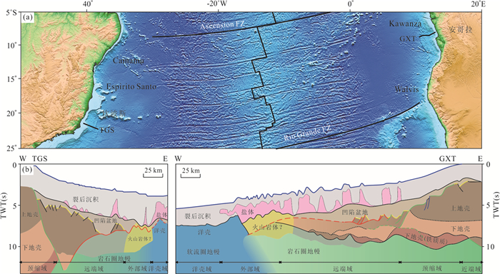
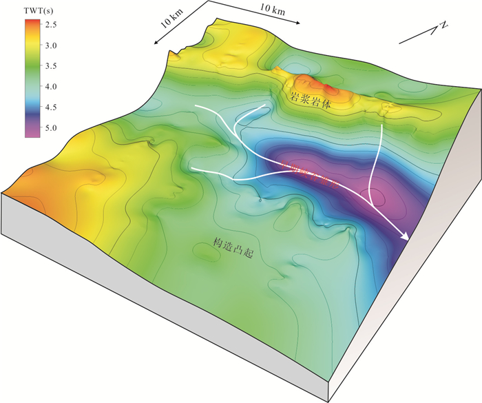
Magma plays a key role in the rifting and breakup process of passive continental margin. Up to 10 km thick high velocity lower crust (HVLC) developed in the northeastern margin. Long term controversy toward its formation mechanism makes the margin classification difficult. In order to analyze the rifting and breakup mechanism of the SCS conjugate margins, this paper reviews the recent research progress of global margins, based on which the crustal structure and magmatic activity of the SCS are summarized. It is concluded that large amounts of magmatic activity occurred in the SCS with discrepancy between the eastern and western margins. The HVLC is thicker in the east and thinner or even absent in the west. It is speculated that the HVLC is of syn-rift underplating. According to the crustal structure and the amount of underplated magma, we suggest that the passive continental margin can be divided into 5 subclasses. The eastern continental margin of the SCS is of magma-robust type, and the middle and western margins are of magma-intermediate and magma-deficient types, respectively.In addition to the stretching rate, plate-edge rifting in the east and plate-interior rifting in the west continental margin may also contribute to the large difference in the amount of magmatic underplating.
Magma plays a key role in the rifting and breakup process of passive continental margin. Up to 10 km thick high velocity lower crust (HVLC) developed in the northeastern margin. Long term controversy toward its formation mechanism makes the margin classification difficult. In order to analyze the rifting and breakup mechanism of the SCS conjugate margins, this paper reviews the recent research progress of global margins, based on which the crustal structure and magmatic activity of the SCS are summarized. It is concluded that large amounts of magmatic activity occurred in the SCS with discrepancy between the eastern and western margins. The HVLC is thicker in the east and thinner or even absent in the west. It is speculated that the HVLC is of syn-rift underplating. According to the crustal structure and the amount of underplated magma, we suggest that the passive continental margin can be divided into 5 subclasses. The eastern continental margin of the SCS is of magma-robust type, and the middle and western margins are of magma-intermediate and magma-deficient types, respectively.In addition to the stretching rate, plate-edge rifting in the east and plate-interior rifting in the west continental margin may also contribute to the large difference in the amount of magmatic underplating.


2021, 46(3): 790-800.
doi: 10.3799/dqkx.2020.303
Abstract:
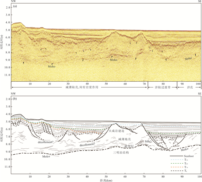
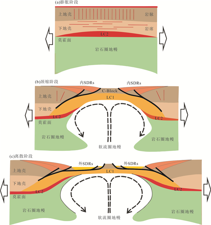
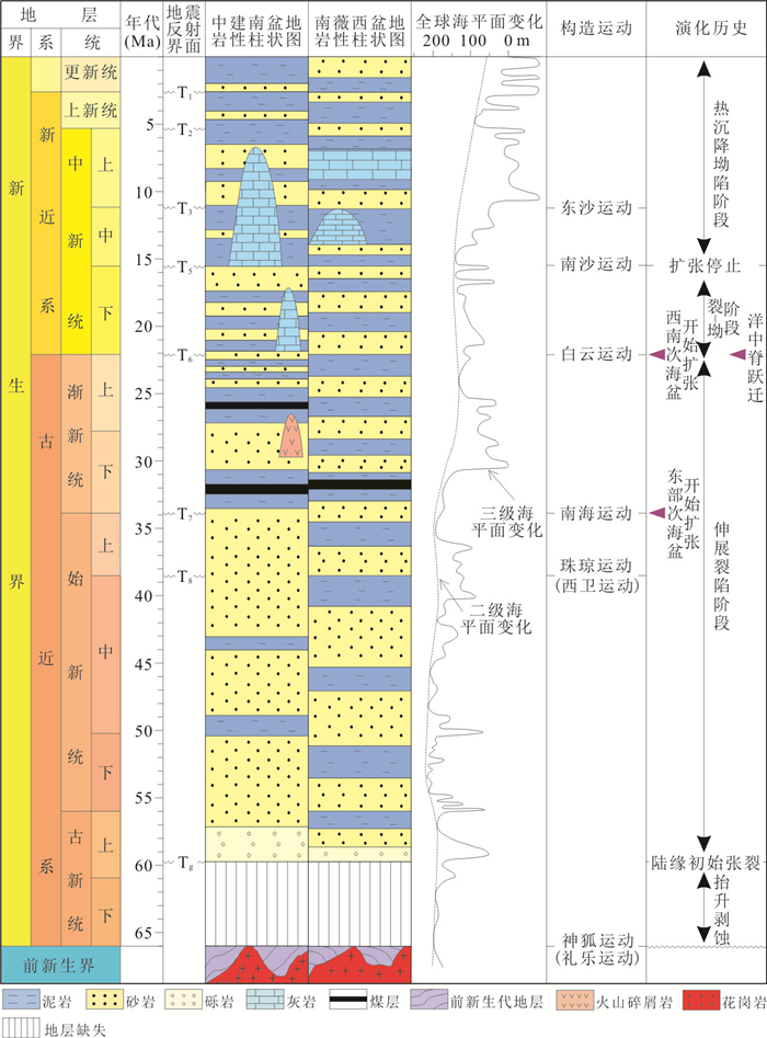
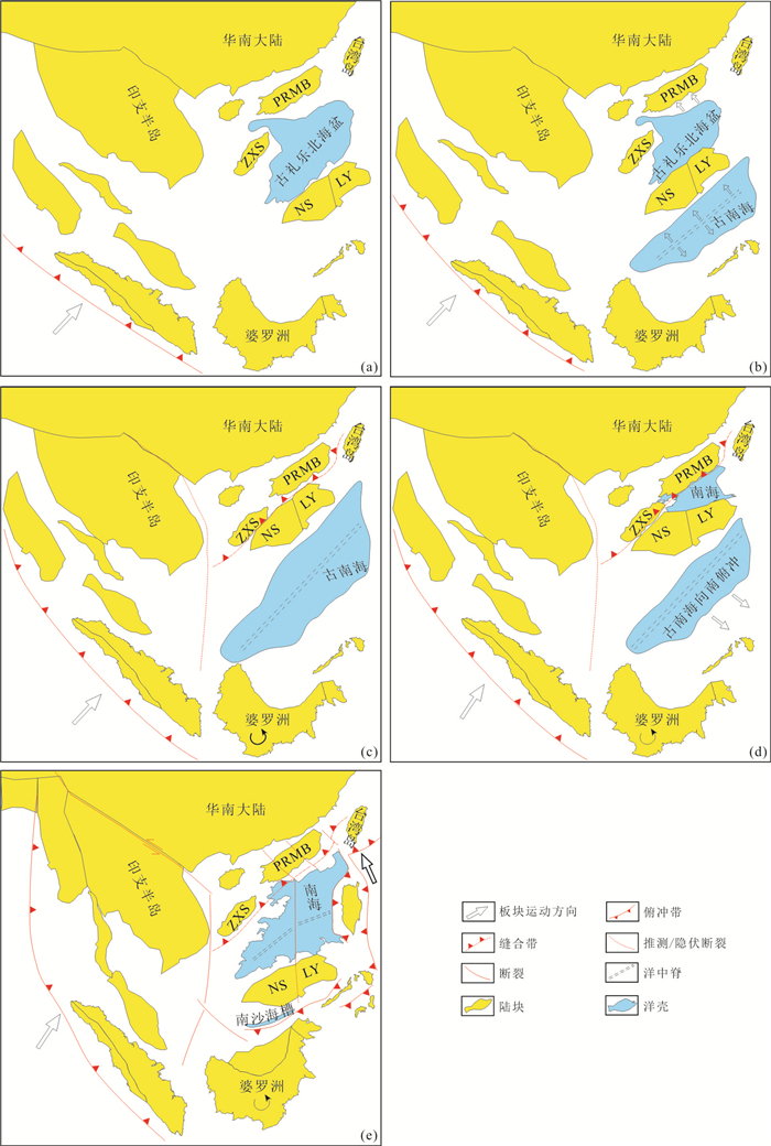
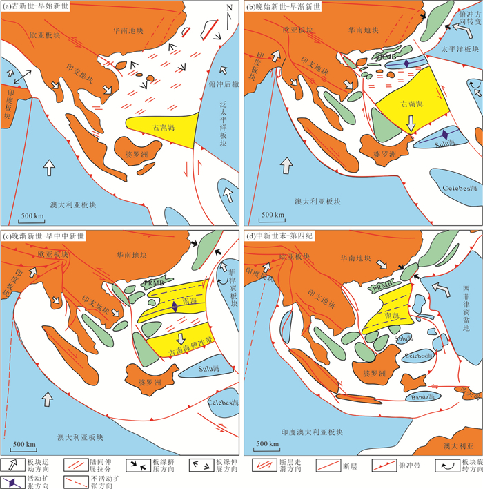
Opening mechanism of marginal basins is one of the fundamental issues of earth science. Based on integrated geological interpretations on deep-reflection seismic and drilling data in the South China Sea (SCS), this study analyzes the deep crustal structure and deformational patterns, the results show: (1) The extension and breakup process of the SCS was ununiform and highly variable, i.e. the continental margin experienced depth-dependent stretching dominated by detachment system, and the breakup process was "a magma-rich" type in the middle-east, but a "magma-poor" one in the west. (2) The spreading process of the SCS was unbalanced and asymmetric, featured with two episodic southward ridge jumps, as well as multiple changes of spreading orientation, resulting in the asymmetric post-spreading magmatism and inhomogeneous lithospheric structure. Base on above-mentioned research, we propose an opening model for tectonic-restricted marginal basins dominated by the West Pacific subduction, which is featured with highly variable continental rifting and ununiform seafloor spreading. The model can enrich the theory of continental margin dynamics.
Opening mechanism of marginal basins is one of the fundamental issues of earth science. Based on integrated geological interpretations on deep-reflection seismic and drilling data in the South China Sea (SCS), this study analyzes the deep crustal structure and deformational patterns, the results show: (1) The extension and breakup process of the SCS was ununiform and highly variable, i.e. the continental margin experienced depth-dependent stretching dominated by detachment system, and the breakup process was "a magma-rich" type in the middle-east, but a "magma-poor" one in the west. (2) The spreading process of the SCS was unbalanced and asymmetric, featured with two episodic southward ridge jumps, as well as multiple changes of spreading orientation, resulting in the asymmetric post-spreading magmatism and inhomogeneous lithospheric structure. Base on above-mentioned research, we propose an opening model for tectonic-restricted marginal basins dominated by the West Pacific subduction, which is featured with highly variable continental rifting and ununiform seafloor spreading. The model can enrich the theory of continental margin dynamics.


2021, 46(3): 801-816.
doi: 10.3799/dqkx.2020.361
Abstract:
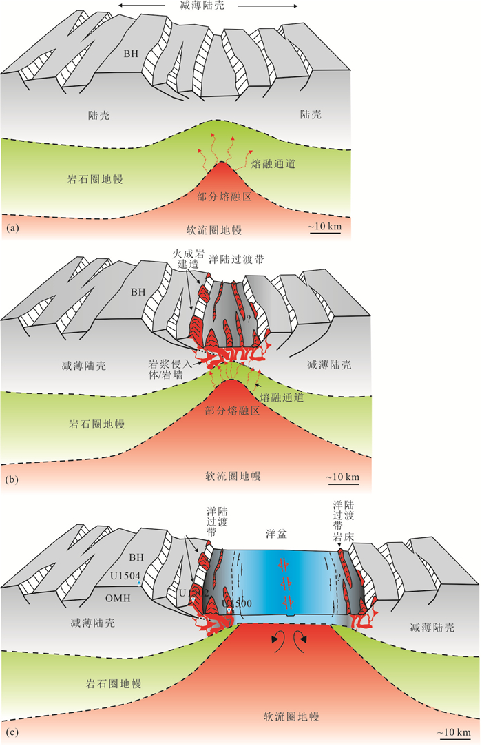
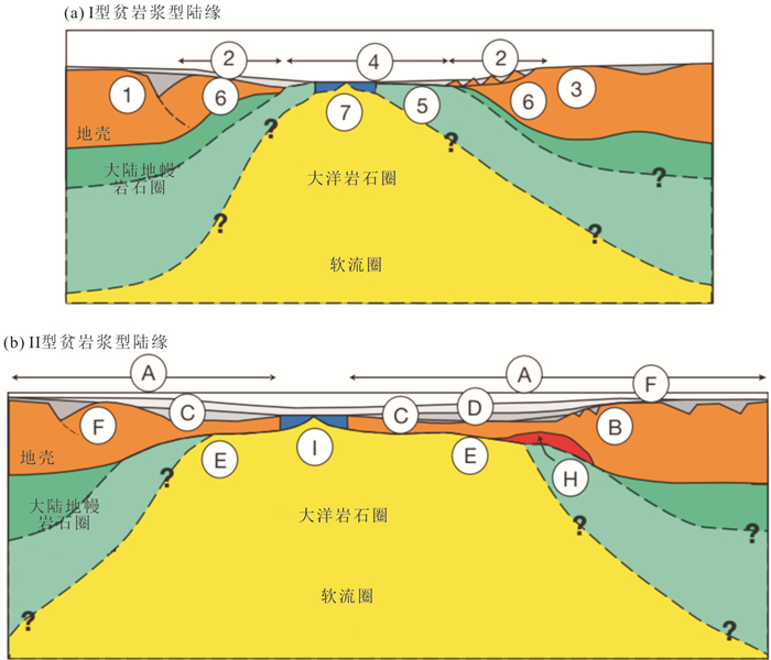
As an important part of Wilson Cycles, the rifted margin is a critical area in the study of plate tectonics and its evolution. By comparing the crustal structure characteristics and evolution process in three typical rifted margins (magma-rich, magma-poor, magma-intermediate), the main factors, e.g., tectonism, magmatic activity, pre-existing structure and so on, are considered to control the formation of different types of rifted margins. In view of the complex tectonic properties and evolution mechanism of the northern margin of the South China Sea (SCS), We propose the key scientific questions and direction for the future: (a) The northern margin of the SCS has a special mechanism possessing partial characteristics of both magma-poor and magma-rich margin; (b) whether the abundant magmatic activities and serpentined mantle exhumation coexist in the northern SCS margin; (c) it is necessary to carry out 3D deep seismic exploration integrated with physical and numerical simulation, so as to establish a scientific and credible geological model of rifting and breakup in the northern SCS margin.
As an important part of Wilson Cycles, the rifted margin is a critical area in the study of plate tectonics and its evolution. By comparing the crustal structure characteristics and evolution process in three typical rifted margins (magma-rich, magma-poor, magma-intermediate), the main factors, e.g., tectonism, magmatic activity, pre-existing structure and so on, are considered to control the formation of different types of rifted margins. In view of the complex tectonic properties and evolution mechanism of the northern margin of the South China Sea (SCS), We propose the key scientific questions and direction for the future: (a) The northern margin of the SCS has a special mechanism possessing partial characteristics of both magma-poor and magma-rich margin; (b) whether the abundant magmatic activities and serpentined mantle exhumation coexist in the northern SCS margin; (c) it is necessary to carry out 3D deep seismic exploration integrated with physical and numerical simulation, so as to establish a scientific and credible geological model of rifting and breakup in the northern SCS margin.


2021, 46(3): 817-825.
doi: 10.3799/dqkx.2020.340
Abstract:
The petit-spot volcanoes discovered near the subduction zone's outer rise represent a new type of seafloor magmatic activity. These volcanoes are small in scale, appear in clusters, and are extremely young. The rock samples are dominated by EM1 alkaline basalt, with high porosity and rich volatile components. The origin of magma of petit-spot volcanoes and the dynamic processes related to magma upwelling are still in debate. This paper presents the characteristics of petit-spot volcanoes and summarizes the three models proposed by previous studies on the formation mechanism and magma sources of these unique volcanoes. Based on the latest findings showing the lithosphere-asthenosphere boundary (LAB) beneath the oceanic plate may contain melts, we infer that the petit-spot volcanoes likely contain the clues about the fundamental scientific question of the nature of LAB. On the other hand, the volcanic rocks are rich in CO2, which likely is the volatiles responsible for melt generation in the asthenosphere and melt accumulation at LAB. Therefore, the petit-spot volcano may also account for an important part of the carbon cycle. Finally, this paper proposes a comprehensive multidisciplinary approach is needed to reveal the formation mechanism of such unique volcanoes.
The petit-spot volcanoes discovered near the subduction zone's outer rise represent a new type of seafloor magmatic activity. These volcanoes are small in scale, appear in clusters, and are extremely young. The rock samples are dominated by EM1 alkaline basalt, with high porosity and rich volatile components. The origin of magma of petit-spot volcanoes and the dynamic processes related to magma upwelling are still in debate. This paper presents the characteristics of petit-spot volcanoes and summarizes the three models proposed by previous studies on the formation mechanism and magma sources of these unique volcanoes. Based on the latest findings showing the lithosphere-asthenosphere boundary (LAB) beneath the oceanic plate may contain melts, we infer that the petit-spot volcanoes likely contain the clues about the fundamental scientific question of the nature of LAB. On the other hand, the volcanic rocks are rich in CO2, which likely is the volatiles responsible for melt generation in the asthenosphere and melt accumulation at LAB. Therefore, the petit-spot volcano may also account for an important part of the carbon cycle. Finally, this paper proposes a comprehensive multidisciplinary approach is needed to reveal the formation mechanism of such unique volcanoes.
2021, 46(3): 826-839.
doi: 10.3799/dqkx.2020.336
Abstract:
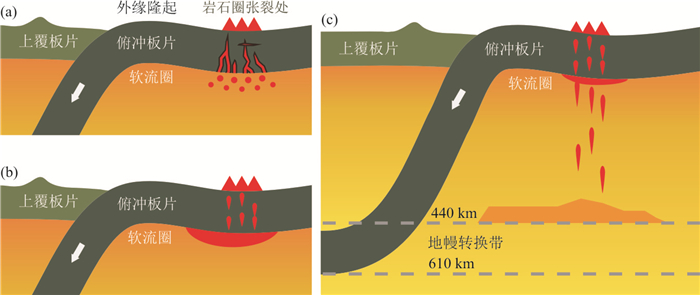
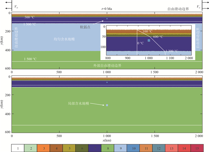
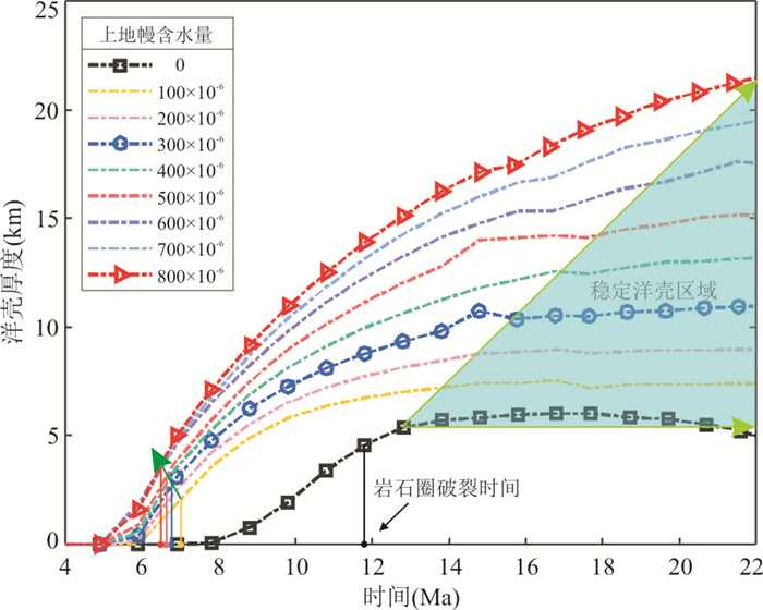
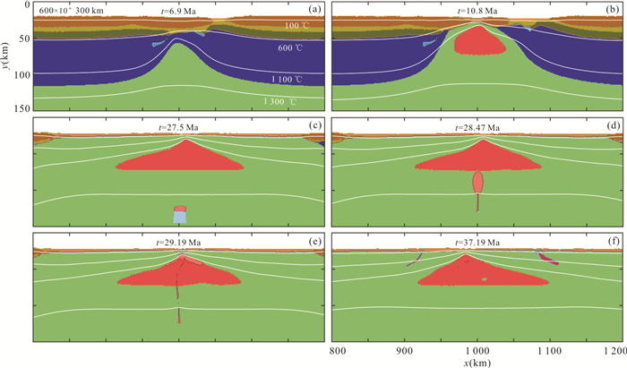
Different contents of water in the mantle have significant effects on the formation of oceanic crust. However, how the homogeneous and local hydrous mantle with different water contents will affect the thickness of oceanic crust are also not clear. Thus we conduct numerical simulations to represent the process of formation. Results show that, in the homogeneous hydrous models, the higher the water content in the upper mantle is, the smaller the maximum melt fraction, the deeper the initiation melting and the bigger melting area will be, finally leading to larger melt volume and the thicker oceanic crust. And in the local hydrous models, the melt of local hydrous mantle can also increase the thickness of oceanic crust, however, the initial time of the effect will depend on its water content. Combining with the characteristics of oceanic crust of the South China Sea, we suggest that the water content in the mantle source during the opening of South China Sea is heterogeneous.The oceanic crustal thickness in eastern sub-basin is 1 km thicker than that of the southwestern sub-basin, possibly because the overall water content of the former is higher than the latter (about 50×10-6, according to our model). And carbonated silicate melts in the basalt of South China Sea may be carried out from deep by the melt which the local hydrous mantle produce in the deep. Moreover, the oceanic crustal thickness does not change greatly with time, which may be due to the volume of the local hydrous mantle is small or the volume is large but its water content is not significantly higher than that in the background.
Different contents of water in the mantle have significant effects on the formation of oceanic crust. However, how the homogeneous and local hydrous mantle with different water contents will affect the thickness of oceanic crust are also not clear. Thus we conduct numerical simulations to represent the process of formation. Results show that, in the homogeneous hydrous models, the higher the water content in the upper mantle is, the smaller the maximum melt fraction, the deeper the initiation melting and the bigger melting area will be, finally leading to larger melt volume and the thicker oceanic crust. And in the local hydrous models, the melt of local hydrous mantle can also increase the thickness of oceanic crust, however, the initial time of the effect will depend on its water content. Combining with the characteristics of oceanic crust of the South China Sea, we suggest that the water content in the mantle source during the opening of South China Sea is heterogeneous.The oceanic crustal thickness in eastern sub-basin is 1 km thicker than that of the southwestern sub-basin, possibly because the overall water content of the former is higher than the latter (about 50×10-6, according to our model). And carbonated silicate melts in the basalt of South China Sea may be carried out from deep by the melt which the local hydrous mantle produce in the deep. Moreover, the oceanic crustal thickness does not change greatly with time, which may be due to the volume of the local hydrous mantle is small or the volume is large but its water content is not significantly higher than that in the background.


2021, 46(3): 840-852.
doi: 10.3799/dqkx.2021.003
Abstract:
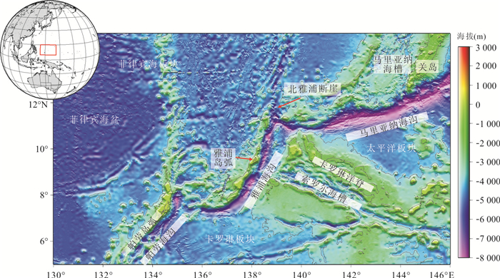
Mantle evolution and magmatism in subduction zone are important geological processes in which circulation of materials and energy takes place among the solid layers of the earth. the Yap trench in the western Pacific ocean is an ideal place to study the evolution of subduction zone under complex conditions because of its unique geological structural characteristics such as extremely short trench-arc distance and ocean ridge-trench collision. In order to explore the mantle evolution and magmatism of the Yap trench, this paper analyzes the genesis of the igneous rocks of the Yap trench by integrating the previous research data on the igneous rocks of the Yap trench. According to the formation conditions of the igneous rocks, the mantle evolution and magmatism during the subduction of the Caroline Plate to the Philippine Sea Plate are discussed. The results show that igneous rocks of the Yap trench have the typical characteristics of subduction-related igneous rocks. The geochemical characteristics of peridotite indicate that the melting degree of mantle in Yap trench is 20%-25%, and the mantle is subjected to metasomatism of fluid and melt during the process of partial melting.The Re-Os isotope characteristics indicate that there is an ancient residual mantle with a Re depleted age of 1.16 Ga in the mantle of the Yap trench, indicating that the mantle may have experienced multi-stage melting events, resulting in a ultra-depleted mantle in the Yap trench. The origin of the Yap arc is still controversial up to now, mainly including: (1) The Yap arc is a part of the ocean crust of the Parece Vela basin, which was thrusting above the original Yap Arc in the Miocene due to the collision of the Caroline ridge. (2) Yap Arc experienced several stages of island arc magmatism in different tectonic periods, including forearc basalts at the initial stage of subduction (~52 Ma), island arc basalts after subduction (~25 Ma), and island arc basalts (7-11 Ma) after collision with the Caroline ridge (21 Ma). The 7-11 Ma island arc basalts indicate that the island arc magmatism in the Yap trench has not completely stopped due to the collision of the Caroline ridge and is likely rejuvenated in the Late Miocene.
Mantle evolution and magmatism in subduction zone are important geological processes in which circulation of materials and energy takes place among the solid layers of the earth. the Yap trench in the western Pacific ocean is an ideal place to study the evolution of subduction zone under complex conditions because of its unique geological structural characteristics such as extremely short trench-arc distance and ocean ridge-trench collision. In order to explore the mantle evolution and magmatism of the Yap trench, this paper analyzes the genesis of the igneous rocks of the Yap trench by integrating the previous research data on the igneous rocks of the Yap trench. According to the formation conditions of the igneous rocks, the mantle evolution and magmatism during the subduction of the Caroline Plate to the Philippine Sea Plate are discussed. The results show that igneous rocks of the Yap trench have the typical characteristics of subduction-related igneous rocks. The geochemical characteristics of peridotite indicate that the melting degree of mantle in Yap trench is 20%-25%, and the mantle is subjected to metasomatism of fluid and melt during the process of partial melting.The Re-Os isotope characteristics indicate that there is an ancient residual mantle with a Re depleted age of 1.16 Ga in the mantle of the Yap trench, indicating that the mantle may have experienced multi-stage melting events, resulting in a ultra-depleted mantle in the Yap trench. The origin of the Yap arc is still controversial up to now, mainly including: (1) The Yap arc is a part of the ocean crust of the Parece Vela basin, which was thrusting above the original Yap Arc in the Miocene due to the collision of the Caroline ridge. (2) Yap Arc experienced several stages of island arc magmatism in different tectonic periods, including forearc basalts at the initial stage of subduction (~52 Ma), island arc basalts after subduction (~25 Ma), and island arc basalts (7-11 Ma) after collision with the Caroline ridge (21 Ma). The 7-11 Ma island arc basalts indicate that the island arc magmatism in the Yap trench has not completely stopped due to the collision of the Caroline ridge and is likely rejuvenated in the Late Miocene.


2021, 46(3): 853-865.
doi: 10.3799/dqkx.2020.341
Abstract:
In order to understand the formation process of marine laminar sediments from multiple perspectives, this paper studied the changes of polycystine radiolarian assemblages and their environmental significance by using the XT47 core samples with laminar diatom mats collected in the western Philippine Sea. Results show that there were abundant radiolarians, generally higher than 2×10⁴ inds. g-1in the upper 260 cm depth; five times of alternating deposition of maximum radiolarian abundances and red clay occurred at the middle 260-460 cm depth; radiolarians in the bottom 460-630 cm depth were rare. According to the early occurrence of radiolarian species, the sediment age of > 470 cm depth was older than 0.34 Ma, suggesting the diatom sediments in the western Philippine Sea were formed since the Middle Pleistocene. The relative abundances of Tetrapyle group and Didymocyrtis tetrathalamus tetrathalamus, which are controlled by warm currents, significantly decreased during the last glacial maximum (LGM) period, indicating that the influence of North Equatorial warm current on the studied areas weakened during the LGM period. Interestingly, the variation of radiolarian abundance shows a different pattern, compared to the change of biogenic silica content, suggesting that the four peaks of biogenic silica content may be caused by the rapid increase of diatom, that is to say, the bloom of Ethmodiscus rex in the western Philippine Sea had a strong-weak fluctuation during the LGM period. Furthermore, four strong blooms of Ethmodiscus rex were found to be good correspondence to the low relative abundances of collodarians, and the high relative abundances of mediate-deep cold species. The former indicates that the stratification of upper water became weakened, and the latter reflects the increase of nutrients in mediate-deep water. Therefore, we believe that four strong blooms of Ethmodiscus rex during the LGM period may be caused by the weak stratification in the upper water and the upwelling of lower water with the abundant nutrients. Our results may provide a possible explanation for the long-term occurrence of the large diatom bloom and the formation of diatom mats with thickness up to three meters on the seafloor in the Phillippine Sea.
In order to understand the formation process of marine laminar sediments from multiple perspectives, this paper studied the changes of polycystine radiolarian assemblages and their environmental significance by using the XT47 core samples with laminar diatom mats collected in the western Philippine Sea. Results show that there were abundant radiolarians, generally higher than 2×10⁴ inds. g-1in the upper 260 cm depth; five times of alternating deposition of maximum radiolarian abundances and red clay occurred at the middle 260-460 cm depth; radiolarians in the bottom 460-630 cm depth were rare. According to the early occurrence of radiolarian species, the sediment age of > 470 cm depth was older than 0.34 Ma, suggesting the diatom sediments in the western Philippine Sea were formed since the Middle Pleistocene. The relative abundances of Tetrapyle group and Didymocyrtis tetrathalamus tetrathalamus, which are controlled by warm currents, significantly decreased during the last glacial maximum (LGM) period, indicating that the influence of North Equatorial warm current on the studied areas weakened during the LGM period. Interestingly, the variation of radiolarian abundance shows a different pattern, compared to the change of biogenic silica content, suggesting that the four peaks of biogenic silica content may be caused by the rapid increase of diatom, that is to say, the bloom of Ethmodiscus rex in the western Philippine Sea had a strong-weak fluctuation during the LGM period. Furthermore, four strong blooms of Ethmodiscus rex were found to be good correspondence to the low relative abundances of collodarians, and the high relative abundances of mediate-deep cold species. The former indicates that the stratification of upper water became weakened, and the latter reflects the increase of nutrients in mediate-deep water. Therefore, we believe that four strong blooms of Ethmodiscus rex during the LGM period may be caused by the weak stratification in the upper water and the upwelling of lower water with the abundant nutrients. Our results may provide a possible explanation for the long-term occurrence of the large diatom bloom and the formation of diatom mats with thickness up to three meters on the seafloor in the Phillippine Sea.


2021, 46(3): 866-884.
doi: 10.3799/dqkx.2020.332
Abstract:
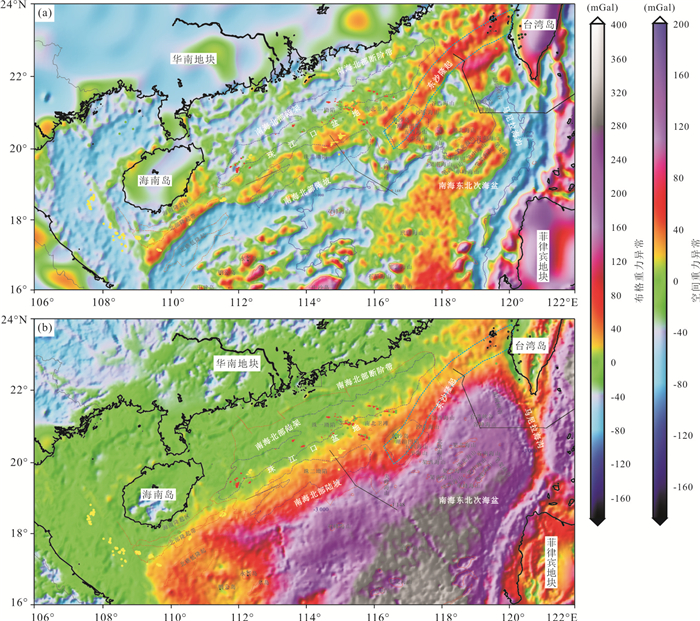
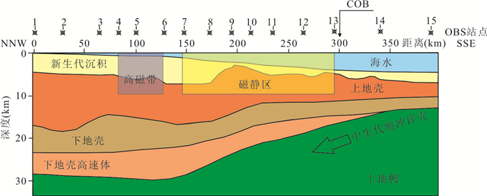
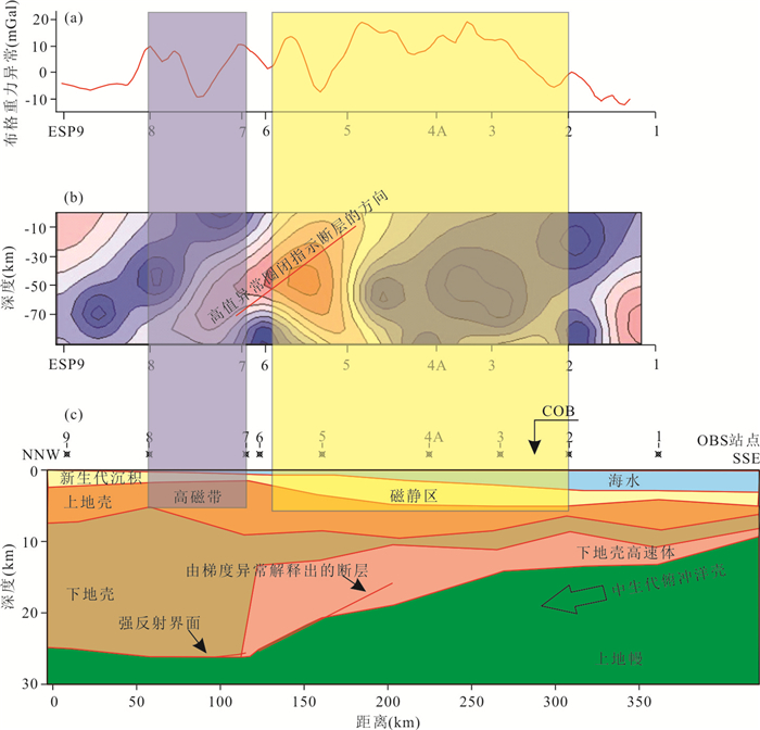
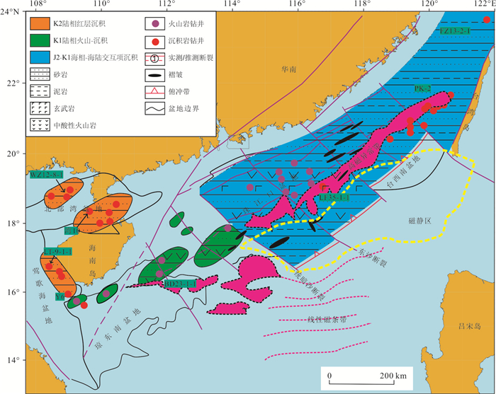
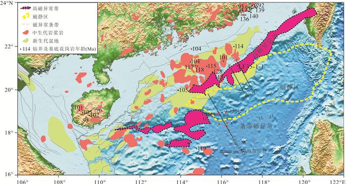
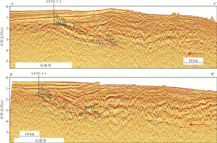
The South China Sea and its adjacent areas are located at the southeast end of the convergence zone of Eurasia and Gondwana, which is an important area where the Tethys tectonic domain meets the Pacific tectonic domain. The Tethys suture zone enters the South China Sea along the Jinshajiang-Ailaoshan structural belt, which suggests that there may be Tethys ocean traces in the South China Sea and that the suture zone exists in the magnetostatic area. Based on the interpretation results of geophysical data on the northern continental slope of the South China Sea, including gravity, magnetic, submarine seismic and deep reflection seismic data, as well as the analyses of regional geological characteristics, this paper studies the genesis of the high magnetic anomaly zone and magnetostatic area in the northern continental margin of the South China Sea. It is considered that the high magnetic anomaly zone is a continental margin volcanic arc formed by the turning and subduction of the Paleo Pacific Plate in the Middle Cretaceous. The magnetostatic area experienced the late continental margin rifting and the opening of the Paleo-South China Sea and South China Sea, and experienced the bottom splitting of high-temperature thermal materials, which caused the crustal tension and thinning, and the Curie uplift to form the magnetostatic area. After the expansion of the South China Sea, the original subduction zone may have migrated to the south of the South China Sea or subducted and disappeared, and there is no suture zone.
The South China Sea and its adjacent areas are located at the southeast end of the convergence zone of Eurasia and Gondwana, which is an important area where the Tethys tectonic domain meets the Pacific tectonic domain. The Tethys suture zone enters the South China Sea along the Jinshajiang-Ailaoshan structural belt, which suggests that there may be Tethys ocean traces in the South China Sea and that the suture zone exists in the magnetostatic area. Based on the interpretation results of geophysical data on the northern continental slope of the South China Sea, including gravity, magnetic, submarine seismic and deep reflection seismic data, as well as the analyses of regional geological characteristics, this paper studies the genesis of the high magnetic anomaly zone and magnetostatic area in the northern continental margin of the South China Sea. It is considered that the high magnetic anomaly zone is a continental margin volcanic arc formed by the turning and subduction of the Paleo Pacific Plate in the Middle Cretaceous. The magnetostatic area experienced the late continental margin rifting and the opening of the Paleo-South China Sea and South China Sea, and experienced the bottom splitting of high-temperature thermal materials, which caused the crustal tension and thinning, and the Curie uplift to form the magnetostatic area. After the expansion of the South China Sea, the original subduction zone may have migrated to the south of the South China Sea or subducted and disappeared, and there is no suture zone.


2021, 46(3): 885-898.
doi: 10.3799/dqkx.2020.369
Abstract:
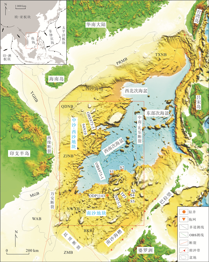
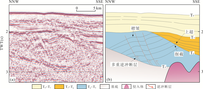
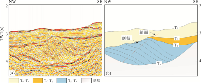
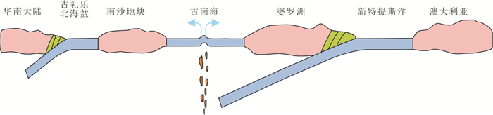
In order to study the tectonic contact relationship of continental margins of the southwest sub-basin, South China Sea in the Late Mesozoic, and its influence on the formation and evolution of the South China Sea, this paper analyzes the crustal structure and Pre-Cenozoic structural deformation of the continental margins of the southwest sub-basin of the South China Sea by the geophysical data and the published data collected from continental margins of the southwest sub-basin. The crust structure and material composition of the continental margins of the southwest sub-basin are different, belonging to two micro blocks with different properties. The Pre-Cenozoic strata of continental margins of the southwest sub-basin experienced compression from different directions in the Late Mesozoic, and suffered uplift and denudation. The continental margins of the southwestern sub-basin were stitched together in the form of subduction collisions in the Late Mesozoic. The subduction zone is the extension of the northern South China Sea subduction zone to the southwest of the South China Sea. The expansion of the South China Sea in Cenozoic is related to the subduction zone, which is the initial fracture site of the South China Sea basin.
In order to study the tectonic contact relationship of continental margins of the southwest sub-basin, South China Sea in the Late Mesozoic, and its influence on the formation and evolution of the South China Sea, this paper analyzes the crustal structure and Pre-Cenozoic structural deformation of the continental margins of the southwest sub-basin of the South China Sea by the geophysical data and the published data collected from continental margins of the southwest sub-basin. The crust structure and material composition of the continental margins of the southwest sub-basin are different, belonging to two micro blocks with different properties. The Pre-Cenozoic strata of continental margins of the southwest sub-basin experienced compression from different directions in the Late Mesozoic, and suffered uplift and denudation. The continental margins of the southwestern sub-basin were stitched together in the form of subduction collisions in the Late Mesozoic. The subduction zone is the extension of the northern South China Sea subduction zone to the southwest of the South China Sea. The expansion of the South China Sea in Cenozoic is related to the subduction zone, which is the initial fracture site of the South China Sea basin.


2021, 46(3): 899-915.
doi: 10.3799/dqkx.2020.393
Abstract:
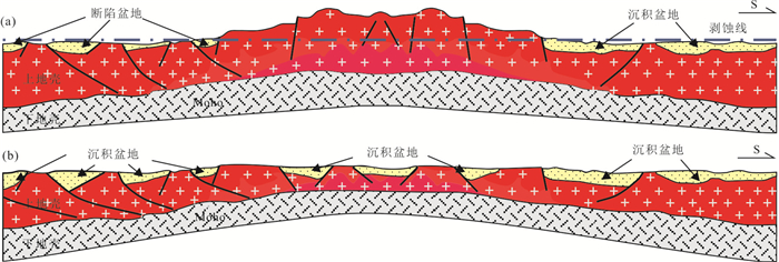
The thin continental crust in the South China Sea belonging to the margin sea is distributed at the sides of the Center basin. The correct understanding of the formation causes of the thin crust is a key link to the tectonic evolution of the South China Sea. Based on the calculation of the crust stretching factors and the interpretation of the crust uplift and erosion since Mesozoic, the formation of the thin continental crust in the South China Sea is considered to be not only by stretch and extension but also by uplift and erosion from Late-Mesozoic to End-Oligocene resulting in the exposure of acid-intrusive rocks on ground and the heterogeneous thickness of the upper crust at thin continental crust. In the South China Sea, the strata in Eocene with both land-marine transitive facies and marine facies deposited at the south margin, but only continental facies deposited at the north margin, which suggests that the basins developed at the north and south continental margins of the South China Sea were of different depositional environments with uplift zones between them. All of the geological characteristics mentioned above indicate that there was ever an occasion of overlap occurring time between the uplift event and extension event. The formation of the thin continental crust in the South China Sea was not only by stretching and extension but also by both extension and erosion. It will reach a wrong conclusion that the extension extent of thin continental crust is still calculated by the formula of the total crustal extensive factor at an area where long-time uplift and erosion once occurred.
The thin continental crust in the South China Sea belonging to the margin sea is distributed at the sides of the Center basin. The correct understanding of the formation causes of the thin crust is a key link to the tectonic evolution of the South China Sea. Based on the calculation of the crust stretching factors and the interpretation of the crust uplift and erosion since Mesozoic, the formation of the thin continental crust in the South China Sea is considered to be not only by stretch and extension but also by uplift and erosion from Late-Mesozoic to End-Oligocene resulting in the exposure of acid-intrusive rocks on ground and the heterogeneous thickness of the upper crust at thin continental crust. In the South China Sea, the strata in Eocene with both land-marine transitive facies and marine facies deposited at the south margin, but only continental facies deposited at the north margin, which suggests that the basins developed at the north and south continental margins of the South China Sea were of different depositional environments with uplift zones between them. All of the geological characteristics mentioned above indicate that there was ever an occasion of overlap occurring time between the uplift event and extension event. The formation of the thin continental crust in the South China Sea was not only by stretching and extension but also by both extension and erosion. It will reach a wrong conclusion that the extension extent of thin continental crust is still calculated by the formula of the total crustal extensive factor at an area where long-time uplift and erosion once occurred.


2021, 46(3): 916-928.
doi: 10.3799/dqkx.2020.381
Abstract:
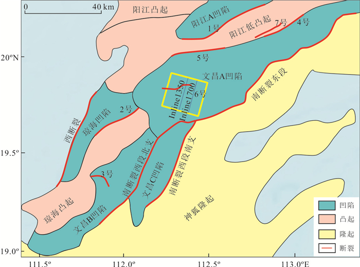
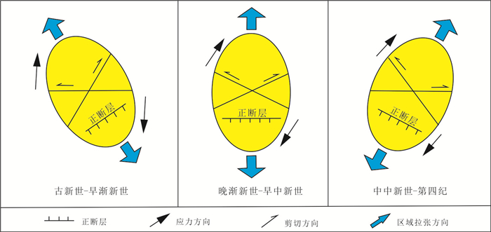
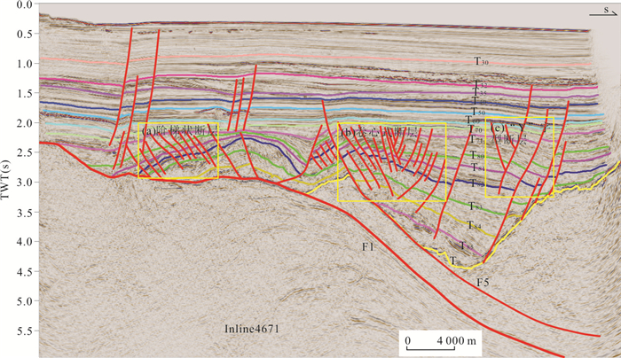
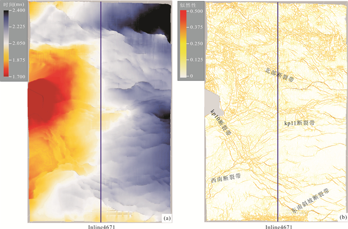
The Pearl River Mouth basin is a rift basin developed in the Cenozoic on the continental margin of the northern South China Sea, which is located in the ocean-continent transition zone with rich oil and gas resources. It is very important to analyze the internal fracture characteristics of the Pearl River Mouth basin. Based on previous studies, this paper uses three-dimensional high-resolution seismic data, combined with the application of coherent attribute analysis technology to refine the interpretation of regional faults. The faults are classified into the first-level basin-controlling faults, the second-level sag-controlling faults, the third-level belt-controlling faults, and the fourth-level ring-controlling faults in the area based on the level and scale of the faults. Single-section fault styles such as normal faults, form step-shaped, "Y"-shaped and other fault combinations on the seismic section. Among them, negative flower-like structures present in the Wenchang A sag in the Zhusan sag and unique core-shaped faults are widely distributed in the Kaiping depression of the Zhuer sag. During the Late Oligocene-Early Miocene, the fault direction rotated clockwise from NE→EW→NWW under the continuous right-handed stress field since the Cenozoic, and the activity intensity gradually weakened. It is also believed that affected by the collision of the India-Eurasia Plate, the subduction and retreat of the Pacific Plate and the continuous southward movement of the Paleo-South China Sea, the basin formed a typical extensional tensile stress field environment, which contributed to the development of three fault groups in NE-NEE and EW direction during the Eocene-Oligocene, and in the NWW-NW direction in Miocene. Moreover, the evolution and genetic mechanism of the fault structure in the southwestern part of the Pearl River Mouth basin are in good agreement with the changes in the stress field at the northern margin of the South China Sea.
The Pearl River Mouth basin is a rift basin developed in the Cenozoic on the continental margin of the northern South China Sea, which is located in the ocean-continent transition zone with rich oil and gas resources. It is very important to analyze the internal fracture characteristics of the Pearl River Mouth basin. Based on previous studies, this paper uses three-dimensional high-resolution seismic data, combined with the application of coherent attribute analysis technology to refine the interpretation of regional faults. The faults are classified into the first-level basin-controlling faults, the second-level sag-controlling faults, the third-level belt-controlling faults, and the fourth-level ring-controlling faults in the area based on the level and scale of the faults. Single-section fault styles such as normal faults, form step-shaped, "Y"-shaped and other fault combinations on the seismic section. Among them, negative flower-like structures present in the Wenchang A sag in the Zhusan sag and unique core-shaped faults are widely distributed in the Kaiping depression of the Zhuer sag. During the Late Oligocene-Early Miocene, the fault direction rotated clockwise from NE→EW→NWW under the continuous right-handed stress field since the Cenozoic, and the activity intensity gradually weakened. It is also believed that affected by the collision of the India-Eurasia Plate, the subduction and retreat of the Pacific Plate and the continuous southward movement of the Paleo-South China Sea, the basin formed a typical extensional tensile stress field environment, which contributed to the development of three fault groups in NE-NEE and EW direction during the Eocene-Oligocene, and in the NWW-NW direction in Miocene. Moreover, the evolution and genetic mechanism of the fault structure in the southwestern part of the Pearl River Mouth basin are in good agreement with the changes in the stress field at the northern margin of the South China Sea.


2021, 46(3): 929-941.
doi: 10.3799/dqkx.2020.338
Abstract:
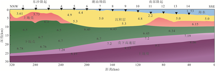
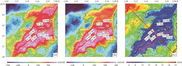
The South China Sea basin has a complex tectonic evolutionary history, but the study of the asymmetry of deep structure and the control factors are still inadequate. The residual mantle Bouguer anomaly (RMBA) of the whole basin is calculated by using the latest gravity data collected from the South China Sea and the accurate sediment data based on the explanation of 27 seismic profiles. The crustal thickness of the basin is inverted, and the correlation analysis is carried out by using Crust1.0 data.The results show that there is obvious asymmetry in topography, RMBA and crustal thickness on each side of South China Sea basin, the north side has more sea mountains, lower RMBA value and thicker oceanic crust than the southern side. This apparent north-south asymmetry indicates a higher mantle temperature and more active magmatic activity on the north side, reflecting the asymmetry of the deep structure of the South China Sea. The asymmetry of this deep structure may be related to the southern jumping of the mid-ocean ridge. The mid-ocean ridge jumping resulted in partial melting between the old and new ridges, leading to higher mantle temperatures on the north side of the expansion center, as well as stronger magmatic activity, which showed more negative RMBA values, thicker oceanic crustal thickness and more after-expansion seamounts.
The South China Sea basin has a complex tectonic evolutionary history, but the study of the asymmetry of deep structure and the control factors are still inadequate. The residual mantle Bouguer anomaly (RMBA) of the whole basin is calculated by using the latest gravity data collected from the South China Sea and the accurate sediment data based on the explanation of 27 seismic profiles. The crustal thickness of the basin is inverted, and the correlation analysis is carried out by using Crust1.0 data.The results show that there is obvious asymmetry in topography, RMBA and crustal thickness on each side of South China Sea basin, the north side has more sea mountains, lower RMBA value and thicker oceanic crust than the southern side. This apparent north-south asymmetry indicates a higher mantle temperature and more active magmatic activity on the north side, reflecting the asymmetry of the deep structure of the South China Sea. The asymmetry of this deep structure may be related to the southern jumping of the mid-ocean ridge. The mid-ocean ridge jumping resulted in partial melting between the old and new ridges, leading to higher mantle temperatures on the north side of the expansion center, as well as stronger magmatic activity, which showed more negative RMBA values, thicker oceanic crustal thickness and more after-expansion seamounts.


2021, 46(3): 942-955.
doi: 10.3799/dqkx.2020.400
Abstract:
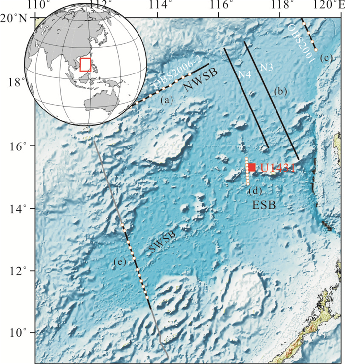
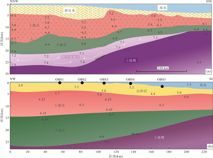
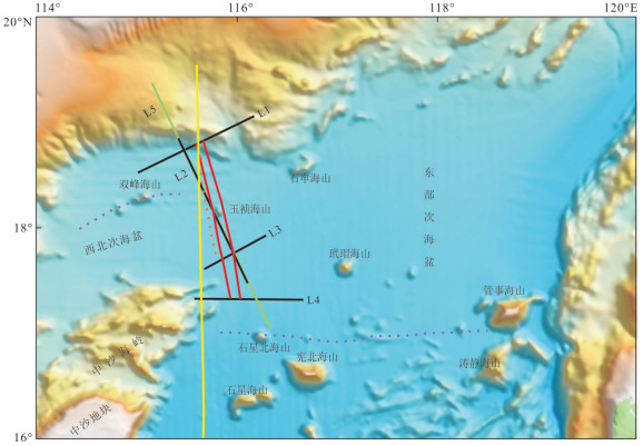
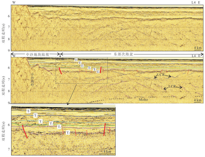
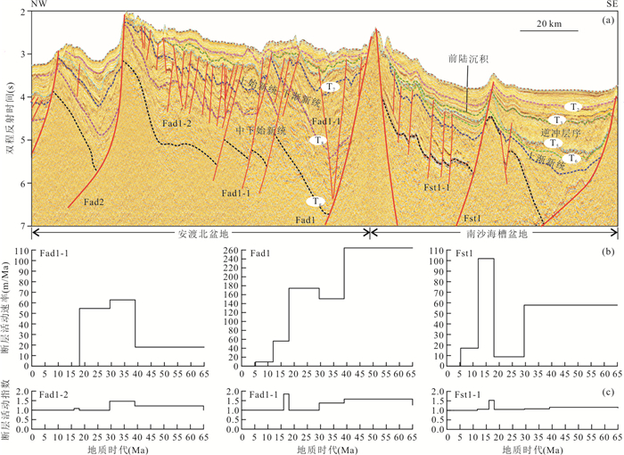
The Zhongnan-Liyue fault zone (ZLFZ) is an important fault zone that coordinated the spread of the sub-oceanic basins in the South China Sea (SCS). In-depth study of the temporal-spatial distribution and deep structures of the ZLFZ is of great significance for understanding the multi-phase spread and tectonic evolution of the SCS Basin. Based on the geological and geophysical data including multi-channel seismic, gravity, magnetic and topographic data, this study reveals the temporal-spatial distribution, internal structural deformation and deep structures about the north segment of ZLFZ in SCS basin. The results show that (1) the width of the ZLFZ between the northwest sub-basin and the eastern sub-basin is about 25-35 km. It starts from the west side of the Zhujiang Sea valley (18.7°N, 115.5°E) and disappears at the northeast of Zhongsha bank (17.2°N, 116.0°E), and is mainly distributed in the NNW direction. The main fault of the ZLFZ is distributed along the seamounts ridge and intrusive body. The faults are mainly developed in the early stage, which are normal faults. (2) The ZLFZ was mainly developed in Oligocene to Early-Miocene and Mid-Miocene to Late-Miocene, the development was mainly inherited. (3) In the deep structures, there are not only different burial depths of the Moho on the west and east sides of the ZLFZ, but also different sedimentary thickness and oceanic crust thickness in the northwest sub-basin and eastern sub-basin. It is speculated that the ZLFZ is at least a crustal-level fault, which may even break through the lithosphere.
The Zhongnan-Liyue fault zone (ZLFZ) is an important fault zone that coordinated the spread of the sub-oceanic basins in the South China Sea (SCS). In-depth study of the temporal-spatial distribution and deep structures of the ZLFZ is of great significance for understanding the multi-phase spread and tectonic evolution of the SCS Basin. Based on the geological and geophysical data including multi-channel seismic, gravity, magnetic and topographic data, this study reveals the temporal-spatial distribution, internal structural deformation and deep structures about the north segment of ZLFZ in SCS basin. The results show that (1) the width of the ZLFZ between the northwest sub-basin and the eastern sub-basin is about 25-35 km. It starts from the west side of the Zhujiang Sea valley (18.7°N, 115.5°E) and disappears at the northeast of Zhongsha bank (17.2°N, 116.0°E), and is mainly distributed in the NNW direction. The main fault of the ZLFZ is distributed along the seamounts ridge and intrusive body. The faults are mainly developed in the early stage, which are normal faults. (2) The ZLFZ was mainly developed in Oligocene to Early-Miocene and Mid-Miocene to Late-Miocene, the development was mainly inherited. (3) In the deep structures, there are not only different burial depths of the Moho on the west and east sides of the ZLFZ, but also different sedimentary thickness and oceanic crust thickness in the northwest sub-basin and eastern sub-basin. It is speculated that the ZLFZ is at least a crustal-level fault, which may even break through the lithosphere.


2021, 46(3): 956-974.
doi: 10.3799/dqkx.2021.009
Abstract:
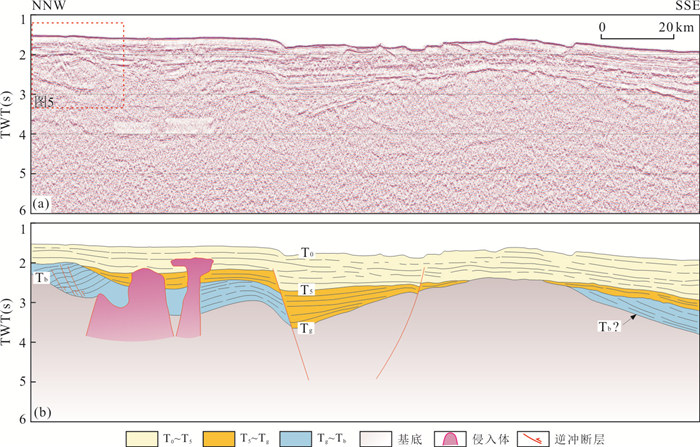
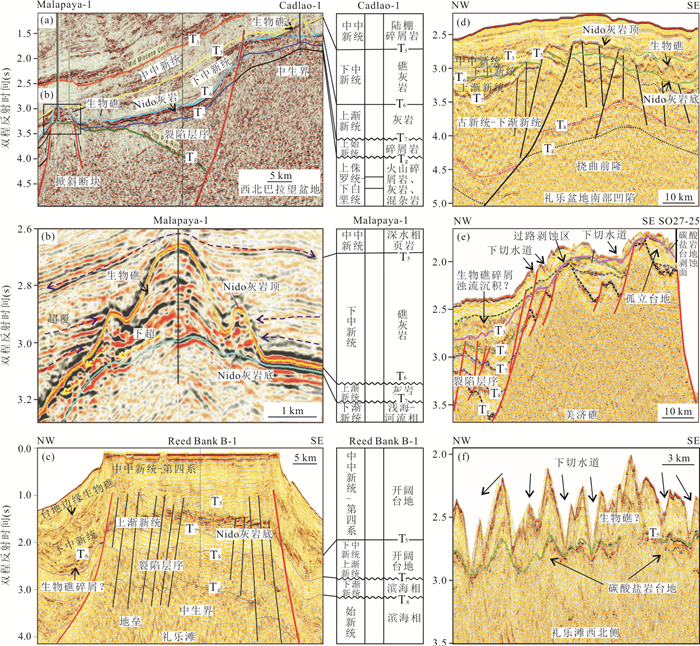
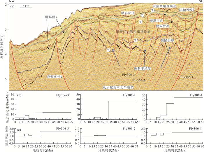
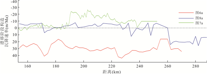
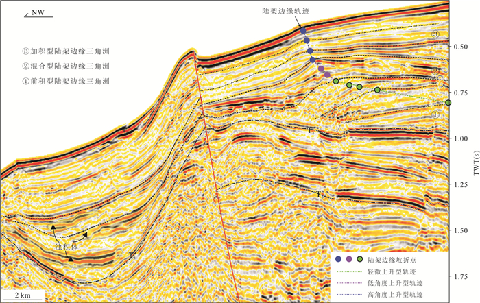
The development characteristics of the carbonate platform and its tectonic controls in the southeast of South China Sea margin are still in debate. Based on wells, dragnets, and large number of 2D seismic data, we interpreted structural and stratigraphic data of the seismic profiles and described the development characteristics and temporal and spatial distribution of carbonate platform. Then the tectonic deformation, subsidence history, and fault activity with the developments of different carbonate platforms were analyzed. The results show that the large-scale contiguous Nido carbonate platform is mainly developed on the tectonic high points of the tilting fault block and the tectonic front uplift, distributed in the northeast to southwest of the study area. Bounded by the Ulugan fault, the Nido platform in the northeast is northwest trending, which is mainly controlled by factors such as the height of the tilting fault block formed by the extensional fault depression, the weak tectonic activity in the expansion stage, and the lack of sediments supply. The Nido platform in the southwest of the Ulugan fault trends to southeast, and it is mainly the structural high point formed by the extensional fault depression in the Late Oligocene, and the relative uplift caused by the flexural forebulge in the Late Oligocene-Early Miocene is related to the migration of the pre-tectonic uplift and sea level changes. The main development period of the carbonate platform coincides with the expansion time of the seafloor and has obvious banding. This feature is related to the pre-existing tectonic background and evolution process at different tectonic locations, reflecting the diachronous breakup of the South China Sea and discordant subduction-collision process.
The development characteristics of the carbonate platform and its tectonic controls in the southeast of South China Sea margin are still in debate. Based on wells, dragnets, and large number of 2D seismic data, we interpreted structural and stratigraphic data of the seismic profiles and described the development characteristics and temporal and spatial distribution of carbonate platform. Then the tectonic deformation, subsidence history, and fault activity with the developments of different carbonate platforms were analyzed. The results show that the large-scale contiguous Nido carbonate platform is mainly developed on the tectonic high points of the tilting fault block and the tectonic front uplift, distributed in the northeast to southwest of the study area. Bounded by the Ulugan fault, the Nido platform in the northeast is northwest trending, which is mainly controlled by factors such as the height of the tilting fault block formed by the extensional fault depression, the weak tectonic activity in the expansion stage, and the lack of sediments supply. The Nido platform in the southwest of the Ulugan fault trends to southeast, and it is mainly the structural high point formed by the extensional fault depression in the Late Oligocene, and the relative uplift caused by the flexural forebulge in the Late Oligocene-Early Miocene is related to the migration of the pre-tectonic uplift and sea level changes. The main development period of the carbonate platform coincides with the expansion time of the seafloor and has obvious banding. This feature is related to the pre-existing tectonic background and evolution process at different tectonic locations, reflecting the diachronous breakup of the South China Sea and discordant subduction-collision process.


2021, 46(3): 975-985.
doi: 10.3799/dqkx.2020.276
Abstract:
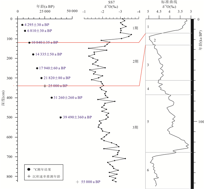
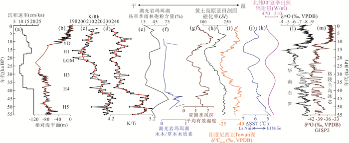
The north slope of Xisha carbonate platform in the northwestern South China Sea is supplied by land and marine biogenic materials, so the sediments contain abundant information on climate change. In order to explore the evolution history of paleoclimate and environment in this area, the 828 cm-long core SS7 was selected for elemental geochemical analysis in combination with the chronological framework established by the AMS14C and oxygen isotope of forams. The results show that the core age at bottom is~55 ka BP, and the elements within sediments are mainly controlled by the terrigenous clastic input, marine authigenesis, redox conditions, and marine chemical deposition. The K/Rb and K/Ti can be used to reflect the surface chemical weathering in the source area and the evolution of the East Asian summer monsoon (EASM) over the past 55 ka. The regional EASM apparently decreased at about 40 ka BP, and the decreases of K/Rb and K/Ti values responded to the rapidly cooling events in the northern hemisphere, including the Heinrich events and the Younger Drays. The EASM over the past 55 ka is not only controlled by the summer insolation in the low-latitude of the northern hemisphere, but also affected by the atmospheric dynamics in the equatorial Pacific (such as the Walker circulation in the Pacific).
The north slope of Xisha carbonate platform in the northwestern South China Sea is supplied by land and marine biogenic materials, so the sediments contain abundant information on climate change. In order to explore the evolution history of paleoclimate and environment in this area, the 828 cm-long core SS7 was selected for elemental geochemical analysis in combination with the chronological framework established by the AMS14C and oxygen isotope of forams. The results show that the core age at bottom is~55 ka BP, and the elements within sediments are mainly controlled by the terrigenous clastic input, marine authigenesis, redox conditions, and marine chemical deposition. The K/Rb and K/Ti can be used to reflect the surface chemical weathering in the source area and the evolution of the East Asian summer monsoon (EASM) over the past 55 ka. The regional EASM apparently decreased at about 40 ka BP, and the decreases of K/Rb and K/Ti values responded to the rapidly cooling events in the northern hemisphere, including the Heinrich events and the Younger Drays. The EASM over the past 55 ka is not only controlled by the summer insolation in the low-latitude of the northern hemisphere, but also affected by the atmospheric dynamics in the equatorial Pacific (such as the Walker circulation in the Pacific).


2021, 46(3): 986-1007.
doi: 10.3799/dqkx.2020.330
Abstract:
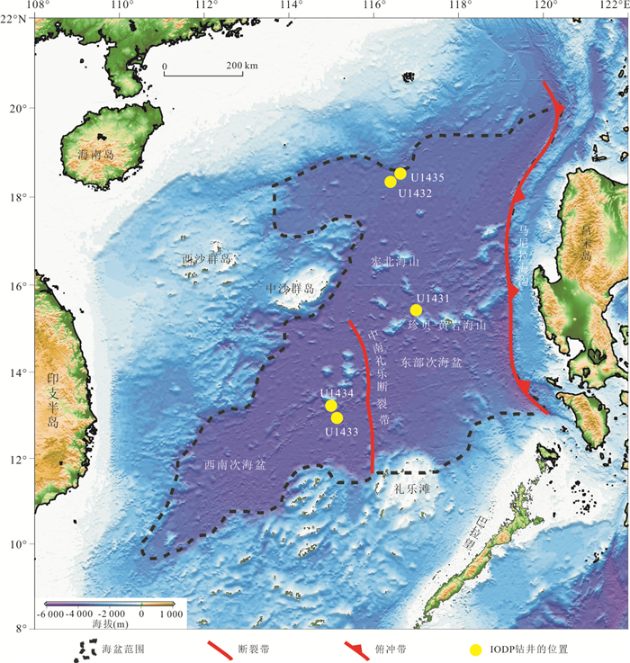
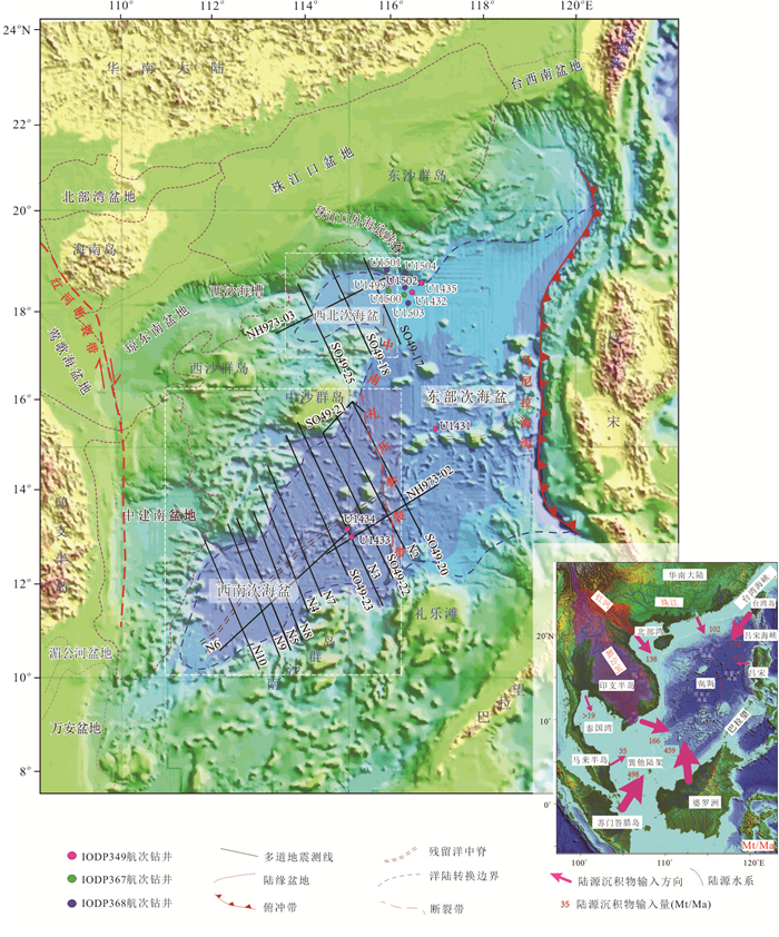
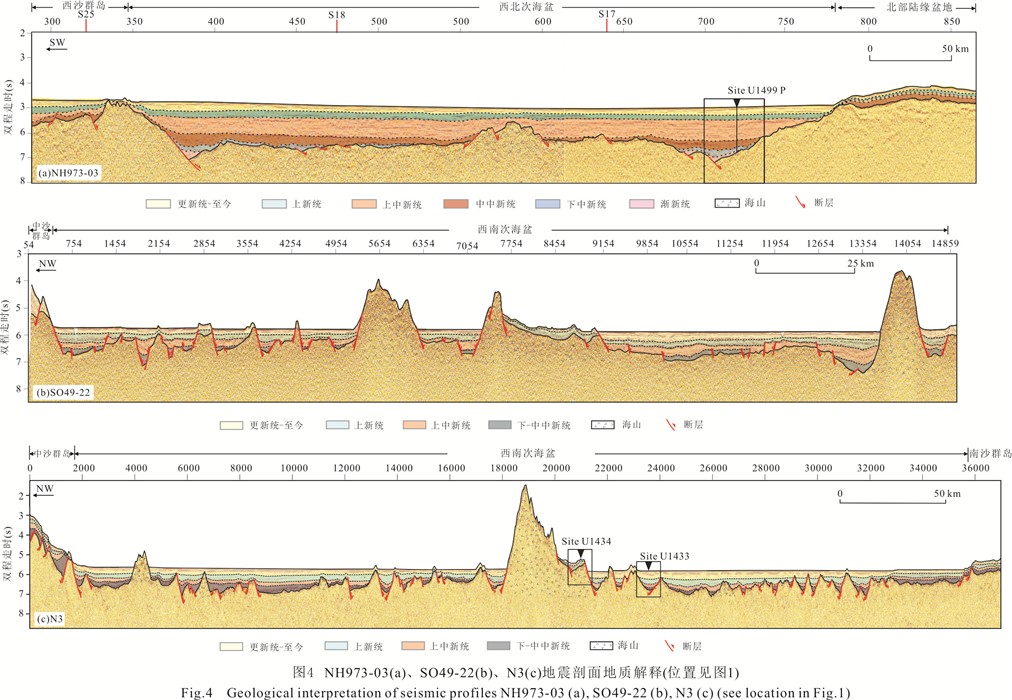
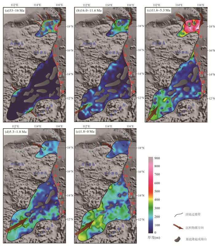
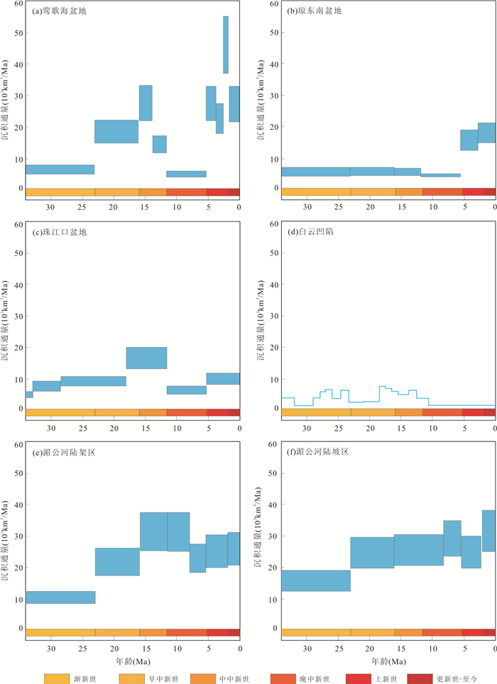
South China Sea (SCS) is not only the crucial pathway for transporting terrigenous materials from Eurasia to the western Pacific Ocean since the Early Oligocene, but also the dominant accumulation and preservation place as a result of limited material exchange between the semi-closed oceanic basin and the open ocean since the Middle Miocene. Calculation of the sedimentary budget in different geological times is an important part in quantifying the sedimentary process in the SCS, which will not only construct the relationship between the sedimentary process of the SCS and the regional tectonic events, climate change, eustatic sea level change, etc, but also to improve our understanding on the "source-to-link" process of the West Pacific region. Based on multichannel seismic profiles across the northwest sub-basin (NWSB) and the southwest sub-basin (SWSB), combined with drilling results from IODP Expeditions, the sedimentary budget of the NWSB and SWSB has been calculated, and the controlling factors in different geological times have been discussed to reconstruct the Cenozoic sedimentary history. Efforts have been also made on the sedimentary provenance analysis. The sedimentary budget of the NWSB and the SWSB showed distinct characteristics in different geological times. Sedimentation is generally dominated by regional tectonic events (such as the uplift of the Tibet Plateau), monsoon, continental fluvial systems and sea-level changes, but will be complicated by local tectonic events and geographic position. The main sediment source of the NWSB was the terrestrial sediment transported from the South China, and a small amount from Red River, the Hainan Island, and Dongsha local uplifts. The sediment provenance of the SWSB was mainly from the Indo-China Peninsula, the Nansha area, and the Palawan before the Late Miocene. After that, sediments were mainly transported from the modern Mekong River.
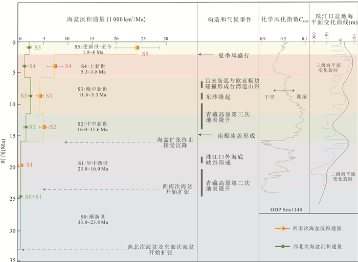
South China Sea (SCS) is not only the crucial pathway for transporting terrigenous materials from Eurasia to the western Pacific Ocean since the Early Oligocene, but also the dominant accumulation and preservation place as a result of limited material exchange between the semi-closed oceanic basin and the open ocean since the Middle Miocene. Calculation of the sedimentary budget in different geological times is an important part in quantifying the sedimentary process in the SCS, which will not only construct the relationship between the sedimentary process of the SCS and the regional tectonic events, climate change, eustatic sea level change, etc, but also to improve our understanding on the "source-to-link" process of the West Pacific region. Based on multichannel seismic profiles across the northwest sub-basin (NWSB) and the southwest sub-basin (SWSB), combined with drilling results from IODP Expeditions, the sedimentary budget of the NWSB and SWSB has been calculated, and the controlling factors in different geological times have been discussed to reconstruct the Cenozoic sedimentary history. Efforts have been also made on the sedimentary provenance analysis. The sedimentary budget of the NWSB and the SWSB showed distinct characteristics in different geological times. Sedimentation is generally dominated by regional tectonic events (such as the uplift of the Tibet Plateau), monsoon, continental fluvial systems and sea-level changes, but will be complicated by local tectonic events and geographic position. The main sediment source of the NWSB was the terrestrial sediment transported from the South China, and a small amount from Red River, the Hainan Island, and Dongsha local uplifts. The sediment provenance of the SWSB was mainly from the Indo-China Peninsula, the Nansha area, and the Palawan before the Late Miocene. After that, sediments were mainly transported from the modern Mekong River.


2021, 46(3): 1008-1022.
doi: 10.3799/dqkx.2020.290
Abstract:
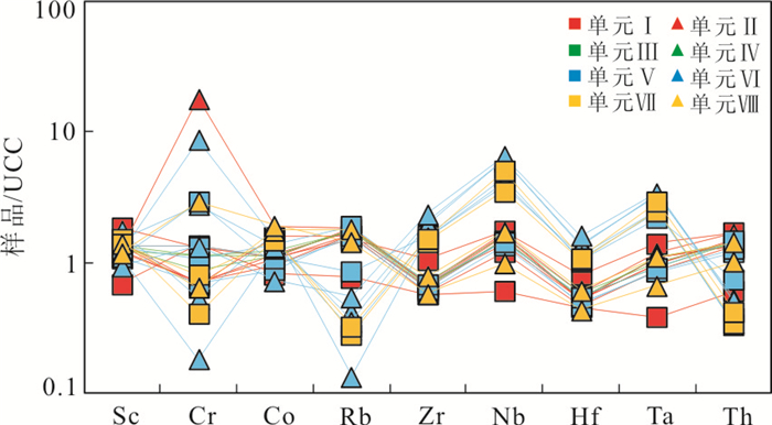
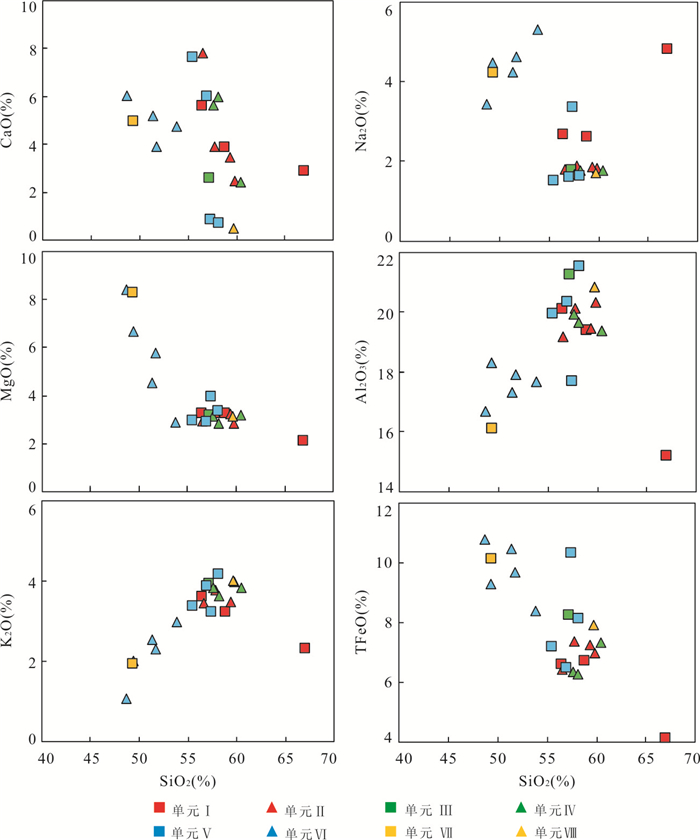
The sedimentary records of the east subbasin in the South China Sea reflect the weathering and evolution history of sediments since the Middle Miocene. We have analyzed the major, trace elements, and Sr-Nd isotopes of the sediments from the International Ocean Discovery Program (IODP) expedition 349 site U1431. The chemical weathering index of alteration (CIA) ranges from 49 to 74, indicating a low to moderate chemical weathering degree of the provenance. The chemical weathering trend shows the preferential leaching of plagioclase. The samples from units Ⅵ, Ⅶ and 55X-2 layer containing pyroclast are affected by the input of mafic materials, while the provenance of other samples is mainly felsic end-members. Sr and Nd isotopes show significant changes in the provenance of the sediments at U1431 site. By analyzing the Sr-Nd isotopic characteristics of sediments from U1431 site and surrounding potential provenance, we inferred the sediments at U1431 site were probably mainly from the Pear River and slightly from the Indochina Peninsula, Luzon and Palawan since 12.8 Ma. Several samples show positive εNd and low 86Sr/87Sr which may be related to the multiple volcanic activities in the study area during 12.5-7.4 Ma. After 6.5 Ma, the terrestrial material formed in the uplifting and erosion of Taiwan Island entered the central basin. Thus, Taiwan Island became one of the main sources.
The sedimentary records of the east subbasin in the South China Sea reflect the weathering and evolution history of sediments since the Middle Miocene. We have analyzed the major, trace elements, and Sr-Nd isotopes of the sediments from the International Ocean Discovery Program (IODP) expedition 349 site U1431. The chemical weathering index of alteration (CIA) ranges from 49 to 74, indicating a low to moderate chemical weathering degree of the provenance. The chemical weathering trend shows the preferential leaching of plagioclase. The samples from units Ⅵ, Ⅶ and 55X-2 layer containing pyroclast are affected by the input of mafic materials, while the provenance of other samples is mainly felsic end-members. Sr and Nd isotopes show significant changes in the provenance of the sediments at U1431 site. By analyzing the Sr-Nd isotopic characteristics of sediments from U1431 site and surrounding potential provenance, we inferred the sediments at U1431 site were probably mainly from the Pear River and slightly from the Indochina Peninsula, Luzon and Palawan since 12.8 Ma. Several samples show positive εNd and low 86Sr/87Sr which may be related to the multiple volcanic activities in the study area during 12.5-7.4 Ma. After 6.5 Ma, the terrestrial material formed in the uplifting and erosion of Taiwan Island entered the central basin. Thus, Taiwan Island became one of the main sources.


2021, 46(3): 1023-1037.
doi: 10.3799/dqkx.2020.277
Abstract:
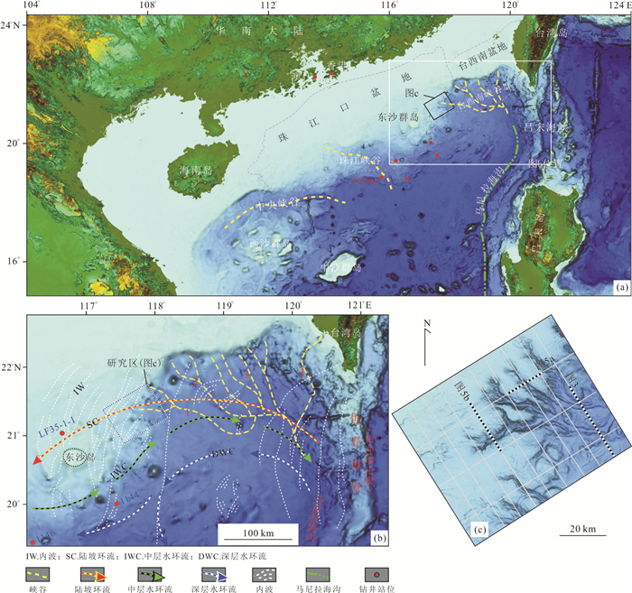
Based on high-resolution 2D multiple channel seismic data and multiple beams, this study investigated the sedimentary sequence, morphological features and depositional architectures of the Dongsha submarine canyon (DSC), to reveal the sedimentary evolution of the DSC and its geological significance in resources exploration. The results show that the upper segment of the DSC consists of six branches with widespread dendritic channels around the canyon heads, which have merged into two main branches at the middle segment. The middle segment of the DSC was initially formed at the late Early Miocene, when the canyon was confined between the tectonic uplift and igneous body. The upper segment of the DSC has begun to extend landwards since the Late Miocene; the formation of the upper-segment branches and dendritic channels at the canyon heads was significantly influenced by faults and strong bottom currents, respectively. The evolution of the DSC could be divided into three stages: (1) The initial development stage from late Early Miocene-Middle Miocene, (2) the expansion stage in Late Miocene, and (3) the modern development stage from Pliocene-present. Since the Late Miocene, the DSC has provided Manila trench with a great amount of organic-rich sediments, which are important materials for producing gas hydrates in the accretionary wedge of the Manila subduction zone.
Based on high-resolution 2D multiple channel seismic data and multiple beams, this study investigated the sedimentary sequence, morphological features and depositional architectures of the Dongsha submarine canyon (DSC), to reveal the sedimentary evolution of the DSC and its geological significance in resources exploration. The results show that the upper segment of the DSC consists of six branches with widespread dendritic channels around the canyon heads, which have merged into two main branches at the middle segment. The middle segment of the DSC was initially formed at the late Early Miocene, when the canyon was confined between the tectonic uplift and igneous body. The upper segment of the DSC has begun to extend landwards since the Late Miocene; the formation of the upper-segment branches and dendritic channels at the canyon heads was significantly influenced by faults and strong bottom currents, respectively. The evolution of the DSC could be divided into three stages: (1) The initial development stage from late Early Miocene-Middle Miocene, (2) the expansion stage in Late Miocene, and (3) the modern development stage from Pliocene-present. Since the Late Miocene, the DSC has provided Manila trench with a great amount of organic-rich sediments, which are important materials for producing gas hydrates in the accretionary wedge of the Manila subduction zone.


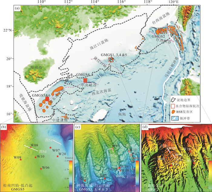
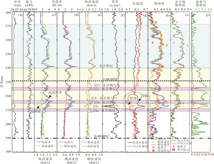
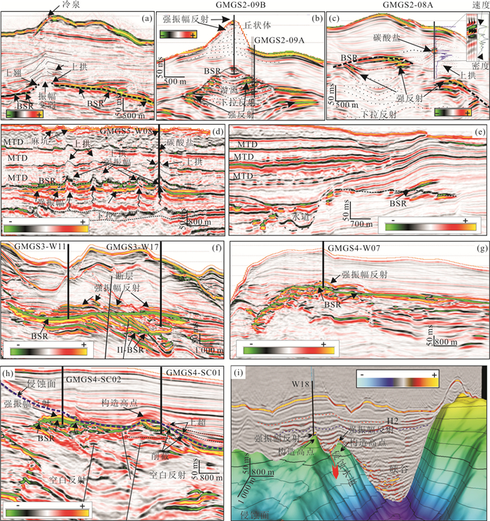
2021, 46(3): 1038-1057.
doi: 10.3799/dqkx.2020.321
Abstract:
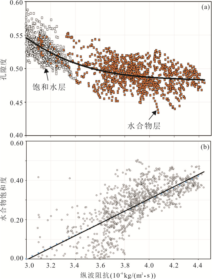
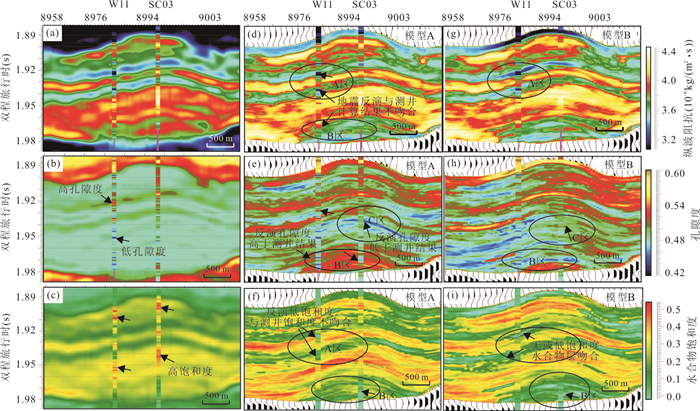
To identify and quantitatively estimate the prospective gas hydrate accumulation, we use the well log, core samples and three dimensional seismic data acquired by six gas hydrate drilling expeditions in the North South China Sea to study the well log and seismic anomalies and characteristics of high concentrated gas hydrate accumulation. (1) Pore-filling and fracture-filling gas hydrate with different saturations have different well log responses and the seismic reflection characteristics. The fracture-filling gas hydrate has the anisotropic characteristics; (2) the concentrated gas hydrate-bearing layers in the silty sediments occur just above the base of gas hydrate stability zone controlled by high flux fluid migration. The high amplitude reflection and the same polarity with the seafloor reflection are the direct indicators for identification of high concentrated gas hydrate accumulation; (3) fracture-filling gas hydrate with moderate saturation in seismic profile is characterized by the pull-up and weak-moderate amplitude reflections. The multi-parameter coupling of reservoir, fluid migration and gas source contributes to the concentrated gas hydrate accumulation, and faults and fluid migration control on the thickness and saturation of gas hydrate-baring sediments in the fine-grained sediments. It is confirmed that geostatistical inversion with the lithofacies constraint of gas hydrate saturation can estimate 3-m-thick non-gas hydrate and low saturation gas hydrate reservoir properties and delineate the spatial distribution.
To identify and quantitatively estimate the prospective gas hydrate accumulation, we use the well log, core samples and three dimensional seismic data acquired by six gas hydrate drilling expeditions in the North South China Sea to study the well log and seismic anomalies and characteristics of high concentrated gas hydrate accumulation. (1) Pore-filling and fracture-filling gas hydrate with different saturations have different well log responses and the seismic reflection characteristics. The fracture-filling gas hydrate has the anisotropic characteristics; (2) the concentrated gas hydrate-bearing layers in the silty sediments occur just above the base of gas hydrate stability zone controlled by high flux fluid migration. The high amplitude reflection and the same polarity with the seafloor reflection are the direct indicators for identification of high concentrated gas hydrate accumulation; (3) fracture-filling gas hydrate with moderate saturation in seismic profile is characterized by the pull-up and weak-moderate amplitude reflections. The multi-parameter coupling of reservoir, fluid migration and gas source contributes to the concentrated gas hydrate accumulation, and faults and fluid migration control on the thickness and saturation of gas hydrate-baring sediments in the fine-grained sediments. It is confirmed that geostatistical inversion with the lithofacies constraint of gas hydrate saturation can estimate 3-m-thick non-gas hydrate and low saturation gas hydrate reservoir properties and delineate the spatial distribution.


2021, 46(3): 1058-1071.
doi: 10.3799/dqkx.2020.185
Abstract:
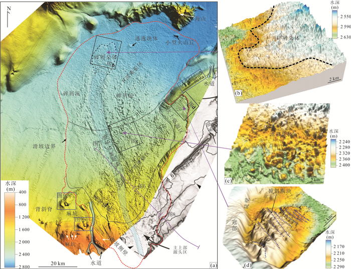
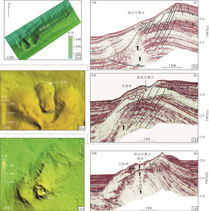
The research on large-scale submarine landslides is of great significance to understanding the stability of submarine slopes. In this paper, a giant submarine landslide on the Nansha trough margin, South China Sea was identified by using the latest high-precision multibeam bathymetry and reprocessed two-dimensional seismic data, and its development characteristics were described. The possible triggering mechanism was discussed. The landslide covers an area of 6 300 km2, spanning 50 km and extending 140 km at most. The upper semicircular headwall domain has developed a basal shear surface and tilted fault blocks. The headwall scarp is 200-350 m high with an average slope of 0.7°. The middle arch-shaped translational domain has a erosional unconformity and voluminous remnant blocks. It is distributed in the depth section of 1 600-2 400 m with an average slope of 1°-3°. The lower fan-shaped toe domain has a detrital lobe deposit and some out-runner blocks. It is distributed in the water depth section of 2 400-2 800 m with an average slope of 0.1°-1.0°. The study indicates that the barrier of the rising anticline ridge to the sediment with high supply rate is an internal condition, but high flux upward fluids and gas hydrates dissociation may be two key preconditioning factors bringing anticlines closer to failure.
The research on large-scale submarine landslides is of great significance to understanding the stability of submarine slopes. In this paper, a giant submarine landslide on the Nansha trough margin, South China Sea was identified by using the latest high-precision multibeam bathymetry and reprocessed two-dimensional seismic data, and its development characteristics were described. The possible triggering mechanism was discussed. The landslide covers an area of 6 300 km2, spanning 50 km and extending 140 km at most. The upper semicircular headwall domain has developed a basal shear surface and tilted fault blocks. The headwall scarp is 200-350 m high with an average slope of 0.7°. The middle arch-shaped translational domain has a erosional unconformity and voluminous remnant blocks. It is distributed in the depth section of 1 600-2 400 m with an average slope of 1°-3°. The lower fan-shaped toe domain has a detrital lobe deposit and some out-runner blocks. It is distributed in the water depth section of 2 400-2 800 m with an average slope of 0.1°-1.0°. The study indicates that the barrier of the rising anticline ridge to the sediment with high supply rate is an internal condition, but high flux upward fluids and gas hydrates dissociation may be two key preconditioning factors bringing anticlines closer to failure.


2021, 46(3): 1072-1082.
doi: 10.3799/dqkx.2021.010
Abstract:
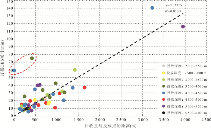
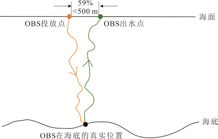
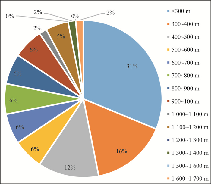
Ocean bottom seismometer (OBS) active and passive experiments are the most useful methods to reveal crustal and upper mantle structures under the ocean, but till now, few OBS experiments have been done in the Arctic and Antarctica, where the main challenges are finding and recovering the OBSs sheltered by the high coverage rate of floating ices. For the forthcoming OBS experiments in the polar regions, it is necessary to study the time and the location of OBS surfacing to the sea (outlet position). To reveal the process of OBS sinking and floating in the sea and to find the law of OBS's outlet position, we use the information of the up-floating rate, deployment position and recovery position of OBS during three expeditions of the 2019 South China Sea OBS observation, 2020 Western Pacific OBS experiment and 2011 the South China Sea three-dimension OBS experiment in this study. The main results are as follows: (1) The OBS shows stable up-floating rate in the vertical direction, which will be helpful to predict the moment of OBS surfacing to the sea; (2) the OBS locations on the sea bottom are randomly distributed with the offset of the drop location, which indicates that the water depth at the drop point has no obvious linear correlation with the relocation offset distance; (3) the outlet position and deployment position of OBS suggest very close distance, with a statistical estimate of < 300 meters (31%) and < 500 meters (59%).
Ocean bottom seismometer (OBS) active and passive experiments are the most useful methods to reveal crustal and upper mantle structures under the ocean, but till now, few OBS experiments have been done in the Arctic and Antarctica, where the main challenges are finding and recovering the OBSs sheltered by the high coverage rate of floating ices. For the forthcoming OBS experiments in the polar regions, it is necessary to study the time and the location of OBS surfacing to the sea (outlet position). To reveal the process of OBS sinking and floating in the sea and to find the law of OBS's outlet position, we use the information of the up-floating rate, deployment position and recovery position of OBS during three expeditions of the 2019 South China Sea OBS observation, 2020 Western Pacific OBS experiment and 2011 the South China Sea three-dimension OBS experiment in this study. The main results are as follows: (1) The OBS shows stable up-floating rate in the vertical direction, which will be helpful to predict the moment of OBS surfacing to the sea; (2) the OBS locations on the sea bottom are randomly distributed with the offset of the drop location, which indicates that the water depth at the drop point has no obvious linear correlation with the relocation offset distance; (3) the outlet position and deployment position of OBS suggest very close distance, with a statistical estimate of < 300 meters (31%) and < 500 meters (59%).


2021, 46(3): 1083-1099.
doi: 10.3799/dqkx.2020.037
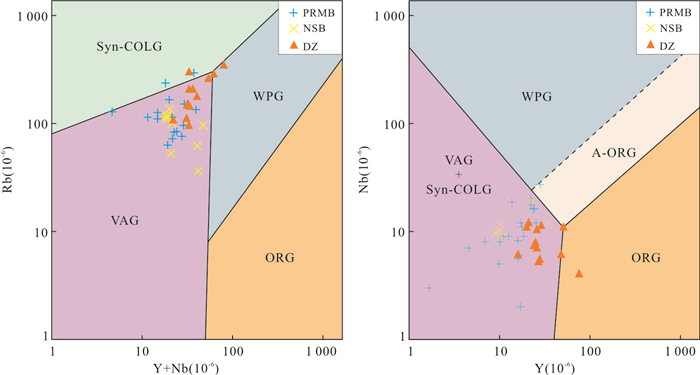
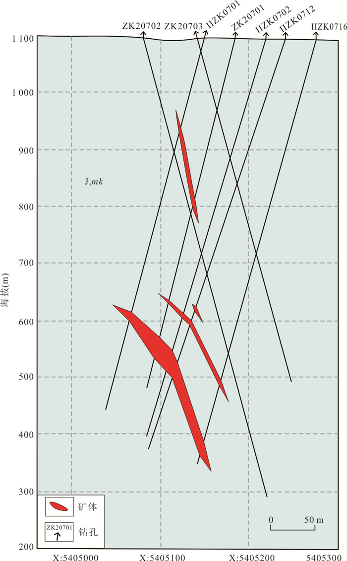
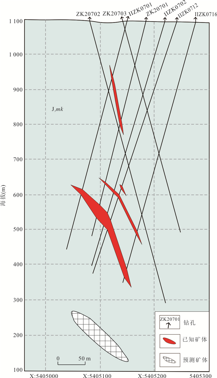
Abstract:
The Wunuer ore deposit is a newly found terrestrial volcanic type deposit, which is located in the middle segment of the Great Xing'an range where is covered by Mesozoic volcanic rocks. In order to provide information for deep prospecting and exploration in this area, in this study, detailed field deposit geology, alteration mineral zonation and primary halo of wall rocks in the deposit were studied. There are obvious multi-stage mineralization characteristics in the Wunuer deposit, including (1) the first stage porphyry type molybdenum mineralization, which mainly occurs in the apical portion of the granite porphyry deep in the deposit; (2) the second stage magmatic hydrothermal fluid (cryptoexplosive breccia) type lead-zinc mineralization, which mainly occurs in cryptoexplosive breccia in the apical portion of the granite porphyry and surrounding wall rocks; (3) the third stage epithermal type lead-zinc-silver mineralization, which mainly occurs in fractures hosted by wall rock in shallow. We have identified at least two tectonic events closely related to ore forming process, which are important ore-controlling factors and prospecting markers. There is obvious wall rock alteration zone in the Wunuer deposit, and the altered mineral assemblage distribution has a good correspondence with the occurrence of ore body, which is one of the important processing markers. Primary halo anomalies of wall rocks are also well correlated with ore bodies, which show obvious lead-near-tail-halo elements zonation, which can provide reliable information for prospecting in the deep of the Wunuer deposit. Based on the above characteristics of ore prospecting information, it is predicted that there is blind ore body deep in the 207 exploration line in Ⅱ of the Wunuer deposit.
The Wunuer ore deposit is a newly found terrestrial volcanic type deposit, which is located in the middle segment of the Great Xing'an range where is covered by Mesozoic volcanic rocks. In order to provide information for deep prospecting and exploration in this area, in this study, detailed field deposit geology, alteration mineral zonation and primary halo of wall rocks in the deposit were studied. There are obvious multi-stage mineralization characteristics in the Wunuer deposit, including (1) the first stage porphyry type molybdenum mineralization, which mainly occurs in the apical portion of the granite porphyry deep in the deposit; (2) the second stage magmatic hydrothermal fluid (cryptoexplosive breccia) type lead-zinc mineralization, which mainly occurs in cryptoexplosive breccia in the apical portion of the granite porphyry and surrounding wall rocks; (3) the third stage epithermal type lead-zinc-silver mineralization, which mainly occurs in fractures hosted by wall rock in shallow. We have identified at least two tectonic events closely related to ore forming process, which are important ore-controlling factors and prospecting markers. There is obvious wall rock alteration zone in the Wunuer deposit, and the altered mineral assemblage distribution has a good correspondence with the occurrence of ore body, which is one of the important processing markers. Primary halo anomalies of wall rocks are also well correlated with ore bodies, which show obvious lead-near-tail-halo elements zonation, which can provide reliable information for prospecting in the deep of the Wunuer deposit. Based on the above characteristics of ore prospecting information, it is predicted that there is blind ore body deep in the 207 exploration line in Ⅱ of the Wunuer deposit.


2021, 46(3): 1100-1118.
doi: 10.3799/dqkx.2020.232
Abstract:
The North Yellow Sea basin in the eastern part of the North China platform from the Middle Jurassic to the Early Cretaceous was influenced by the transformation from Paleo-Asian tectonic system to Marginal Pacific tectonic system, and its tectonic evolution experienced transformations of extension-compression-extension. The differences of tectonic systems are shown not only in the geotectonic properties and their geological effects, but also in the sedimentary characteristics of the basin, paleontology and paleoclimate. In this paper, the Middle Jurassic to Lower Cretaceous of the well X1 in the eastern depression of the North Yellow Sea basin is taken as the research object, and the paleoclimate evolution is studied by using the indication of mudstone element geochemical characteristics to paleoclimate, combined with basin sedimentary characteristics and paleobiological data. Research results show that, the longitudinal changes of Sr/Cu(2.12-34.10), Sr/Ba(0.16-1.60), Rb/Sr(0.13-1.23), Fe2O3/FeO(0.22-11.10), V/Cr(0.91-1.78), V/Sc(4.89-8.33), Ni/Co(1.14-3.85), δU(0.50-0.84), U/Th(0.11-0.24) from the Middle Jurassic to the Early Cretaceous reflect that the paleoclimate evolution experienced variations from warm and humid to whole humid, short dry and hot to dry and hot. The sediments experienced the main changes form dark fine-grained sediments to gray, gray interbedded with gray-green, gray and reddish brown interbedded fine sediments to gray coarse-grained sediments and reddish-brown and grayish-yellow fine-grained sediments. Paleontology experienced the process of abundance of hygrophilous plants-appearance of heat-loving plants-abundance of heat-loving plants. The results show that the North China platform drifted northward due to the influence of Paleo-Asian tectonic system and Marginal Pacific tectonic system. At the same time, the paleoclimate evolution of the North Yellow Sea basin underwent a dramatic change from the Middle Jurassic to the late Late Cretaceous; during the Middle Jurassic to the early Late Jurassic, it was dominated by warm and humid climate; from the late Late Jurassic to the early Early Cretaceous the whole climate was relatively wet, with a short dry and hot climate; from the middle Early Cretaceous to the late Early Cretaceous it was dry and hot climate. The paleoclimate in the North Yellow Sea basin has experienced the evolution from a warm and humid climate to dry and hot climate during the Middle Jurassic-the Early Cretaceous, which is a response to the transformation of two major Mesozoic tectonic regimes in the east of North China platform.
The North Yellow Sea basin in the eastern part of the North China platform from the Middle Jurassic to the Early Cretaceous was influenced by the transformation from Paleo-Asian tectonic system to Marginal Pacific tectonic system, and its tectonic evolution experienced transformations of extension-compression-extension. The differences of tectonic systems are shown not only in the geotectonic properties and their geological effects, but also in the sedimentary characteristics of the basin, paleontology and paleoclimate. In this paper, the Middle Jurassic to Lower Cretaceous of the well X1 in the eastern depression of the North Yellow Sea basin is taken as the research object, and the paleoclimate evolution is studied by using the indication of mudstone element geochemical characteristics to paleoclimate, combined with basin sedimentary characteristics and paleobiological data. Research results show that, the longitudinal changes of Sr/Cu(2.12-34.10), Sr/Ba(0.16-1.60), Rb/Sr(0.13-1.23), Fe2O3/FeO(0.22-11.10), V/Cr(0.91-1.78), V/Sc(4.89-8.33), Ni/Co(1.14-3.85), δU(0.50-0.84), U/Th(0.11-0.24) from the Middle Jurassic to the Early Cretaceous reflect that the paleoclimate evolution experienced variations from warm and humid to whole humid, short dry and hot to dry and hot. The sediments experienced the main changes form dark fine-grained sediments to gray, gray interbedded with gray-green, gray and reddish brown interbedded fine sediments to gray coarse-grained sediments and reddish-brown and grayish-yellow fine-grained sediments. Paleontology experienced the process of abundance of hygrophilous plants-appearance of heat-loving plants-abundance of heat-loving plants. The results show that the North China platform drifted northward due to the influence of Paleo-Asian tectonic system and Marginal Pacific tectonic system. At the same time, the paleoclimate evolution of the North Yellow Sea basin underwent a dramatic change from the Middle Jurassic to the late Late Cretaceous; during the Middle Jurassic to the early Late Jurassic, it was dominated by warm and humid climate; from the late Late Jurassic to the early Early Cretaceous the whole climate was relatively wet, with a short dry and hot climate; from the middle Early Cretaceous to the late Early Cretaceous it was dry and hot climate. The paleoclimate in the North Yellow Sea basin has experienced the evolution from a warm and humid climate to dry and hot climate during the Middle Jurassic-the Early Cretaceous, which is a response to the transformation of two major Mesozoic tectonic regimes in the east of North China platform.


2021, 46(3): 1119-1132.
doi: 10.3799/dqkx.2020.403
Abstract:
Linsishan Formation is one of the important stratigraphic units at the bottom of the Early Cretaceous Laiyang Group in the Jiaolai basin. The accurate determination of depositional timing and provenance characteristics of the Linsishan Formation is of great importance for the objective reconstruction of the Late Mesozoic tectonic framework in the eastern part of the North China Block and the Late Mesozoic exhumation process of the surrounding orogenic belt/Precambrian basement. In this paper, we present an integrated study involving detailed field geological investigation, petrographic observation, zircon and U-Pb dating and in situ trace element analysis of the fine-grade conglomerates from the Linsishan Formation in the Laiyang Group, and the following conclusions are suggested: (1) The weighted mean age of the youngest group of detrital zircons in the fine-grade conglomerates of Linsishan Formation are 129±1 Ma and 127±5 Ma, combining with the zircon concordant age of 119±1 Ma yielded by magmatic zircons in the volcanic rocks from the Qingshan Group. It is speculated that the depositional timing of the Linsishan Formation in the Shewopo area is 127-119 Ma. (2) The detrital zircon ages of the fine-grade conglomerate of the Linsishan Formation in the Shewopo area range from 2 858 to 126 Ma, respectively, and are marked by the occurrence of the Late Neoarchean and Early Cretaceous ages. The pre-Paleoproterozoic detrital zircons are mainly derived from Precambrian metamorphic rocks of the Jiaobei terrane, indicating that the Archean-Paleoproterozoic metamorphic rocks of the Jiaobei terrane have exhumated to the near surface at least in the Early Cretaceous. (3) The 160-120 Ma magmatic detrital zircons are mainly derived from the synchronous intermediate acid intrusions in Jiaodong, suggesting that at least part of the 160-120 Ma intermediate acid intrusions have returned to the surface during the Early Cretaceous. (4) Permian (280 Ma) and Late-Triassic (213 Ma) metamorphic zircons which are identified in the Linsishan Formation, not only indicate that the Late Paleozoic (280 Ma) metamorphic event may have occurred in Jiaodong Peninsula, and but also reveal that Sulu UHP metamorphic rocks have exhumed to the surface during the Early Cretaceous.
Linsishan Formation is one of the important stratigraphic units at the bottom of the Early Cretaceous Laiyang Group in the Jiaolai basin. The accurate determination of depositional timing and provenance characteristics of the Linsishan Formation is of great importance for the objective reconstruction of the Late Mesozoic tectonic framework in the eastern part of the North China Block and the Late Mesozoic exhumation process of the surrounding orogenic belt/Precambrian basement. In this paper, we present an integrated study involving detailed field geological investigation, petrographic observation, zircon and U-Pb dating and in situ trace element analysis of the fine-grade conglomerates from the Linsishan Formation in the Laiyang Group, and the following conclusions are suggested: (1) The weighted mean age of the youngest group of detrital zircons in the fine-grade conglomerates of Linsishan Formation are 129±1 Ma and 127±5 Ma, combining with the zircon concordant age of 119±1 Ma yielded by magmatic zircons in the volcanic rocks from the Qingshan Group. It is speculated that the depositional timing of the Linsishan Formation in the Shewopo area is 127-119 Ma. (2) The detrital zircon ages of the fine-grade conglomerate of the Linsishan Formation in the Shewopo area range from 2 858 to 126 Ma, respectively, and are marked by the occurrence of the Late Neoarchean and Early Cretaceous ages. The pre-Paleoproterozoic detrital zircons are mainly derived from Precambrian metamorphic rocks of the Jiaobei terrane, indicating that the Archean-Paleoproterozoic metamorphic rocks of the Jiaobei terrane have exhumated to the near surface at least in the Early Cretaceous. (3) The 160-120 Ma magmatic detrital zircons are mainly derived from the synchronous intermediate acid intrusions in Jiaodong, suggesting that at least part of the 160-120 Ma intermediate acid intrusions have returned to the surface during the Early Cretaceous. (4) Permian (280 Ma) and Late-Triassic (213 Ma) metamorphic zircons which are identified in the Linsishan Formation, not only indicate that the Late Paleozoic (280 Ma) metamorphic event may have occurred in Jiaodong Peninsula, and but also reveal that Sulu UHP metamorphic rocks have exhumed to the surface during the Early Cretaceous.