2021 Vol. 46, No. 5
Display Method:
 PDF 482KB
2021, 46(5): 1537-1553.
doi: 10.3799/dqkx.2020.105
Abstract:
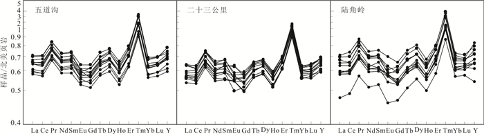
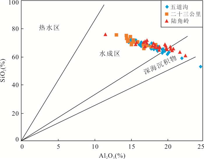
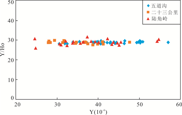
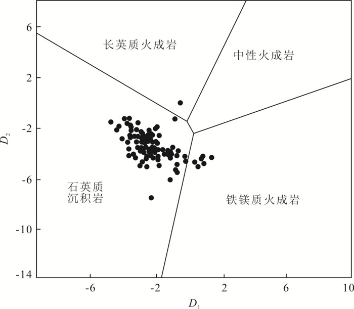
The metallogenic belt in the Taiping Mountains is one of the most important copper-gold polymetallic metallogenic belts in Heilongjiang Province,in which mesothermal hydrothermal vein dominates,followed by porphyry,epithermal and magmatic type deposits. The Lower Permian Shuangqiaozi Formation (P1s) is widely developed in this region,and is composed of pelite,siltstone,and sandstone,with multiple layers of intermediate-felsic volcanic rocks. The contents of Au,P,and Fe are relatively high in this stratum. In recent years,small scale gold deposits such as Lujiaoling,Wudaogou-23 Gongli have been found in Dongning County and Muleng City. The gold ore bodies are developed in P1s as veins,but the grade of gold is low,which directly affects the next step of exploration. Based on field investigations,in this paper it uses rock geochemistry,X-ray powder diffraction,and organic carbon analysis to determine the rock types,sedimentary sources,and sources of ore-forming elements such as Au. The contents of major elements display small variations. Compared with PAAS,the rocks are slightly depleted in Al2O3,P2O5,CaO,and MnO2,and moderately depleted in Na2O,MgO,TiO2,and Fe2O3. All trace elements except Zn yield lower contents. The total amount of rare earth elements is equivalent to that of North American shale,and the differentiation of light and heavy rare earth elements is slightly lower than that of North American shale. The rocks are dominated by clay minerals (illite,chlorite) and quartz,with various amounts of albite and minor carbonate minerals and pyrite. The TOC contents of the rock range from 0.22% to 2.52%,with an average of 1.10%. There is no correlation between the contents of Au and TOC and clay minerals. It is suggested that P1s in the area is composed of carbonaceous slate,and the sediments were mainly derived from the weathering products of quartzose sedimentary rocks,with a small amount derived from femic igneous rocks. The deposition environment is near-shore. The high contents of gold in the stratum were not brought by the fluids after diagenesis and adsorbed by the rich organic compounds or clay minerals,but derived from terrigenous weathering products. This indicates that the gold deposits developed in P1s in this area are not stratabound gold deposits,but hydrothermal vein type deposits controlled by faults.
The metallogenic belt in the Taiping Mountains is one of the most important copper-gold polymetallic metallogenic belts in Heilongjiang Province,in which mesothermal hydrothermal vein dominates,followed by porphyry,epithermal and magmatic type deposits. The Lower Permian Shuangqiaozi Formation (P1s) is widely developed in this region,and is composed of pelite,siltstone,and sandstone,with multiple layers of intermediate-felsic volcanic rocks. The contents of Au,P,and Fe are relatively high in this stratum. In recent years,small scale gold deposits such as Lujiaoling,Wudaogou-23 Gongli have been found in Dongning County and Muleng City. The gold ore bodies are developed in P1s as veins,but the grade of gold is low,which directly affects the next step of exploration. Based on field investigations,in this paper it uses rock geochemistry,X-ray powder diffraction,and organic carbon analysis to determine the rock types,sedimentary sources,and sources of ore-forming elements such as Au. The contents of major elements display small variations. Compared with PAAS,the rocks are slightly depleted in Al2O3,P2O5,CaO,and MnO2,and moderately depleted in Na2O,MgO,TiO2,and Fe2O3. All trace elements except Zn yield lower contents. The total amount of rare earth elements is equivalent to that of North American shale,and the differentiation of light and heavy rare earth elements is slightly lower than that of North American shale. The rocks are dominated by clay minerals (illite,chlorite) and quartz,with various amounts of albite and minor carbonate minerals and pyrite. The TOC contents of the rock range from 0.22% to 2.52%,with an average of 1.10%. There is no correlation between the contents of Au and TOC and clay minerals. It is suggested that P1s in the area is composed of carbonaceous slate,and the sediments were mainly derived from the weathering products of quartzose sedimentary rocks,with a small amount derived from femic igneous rocks. The deposition environment is near-shore. The high contents of gold in the stratum were not brought by the fluids after diagenesis and adsorbed by the rich organic compounds or clay minerals,but derived from terrigenous weathering products. This indicates that the gold deposits developed in P1s in this area are not stratabound gold deposits,but hydrothermal vein type deposits controlled by faults.


2021, 46(5): 1554-1568.
doi: 10.3799/dqkx.2020.328
Abstract:
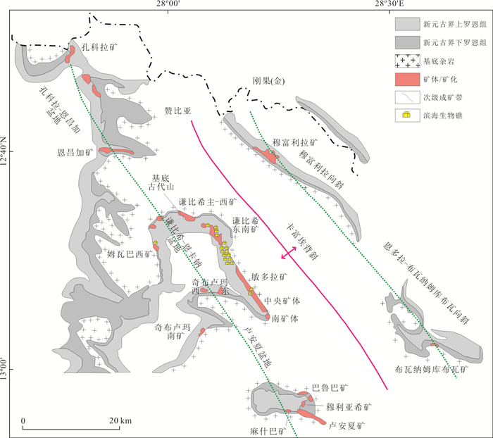
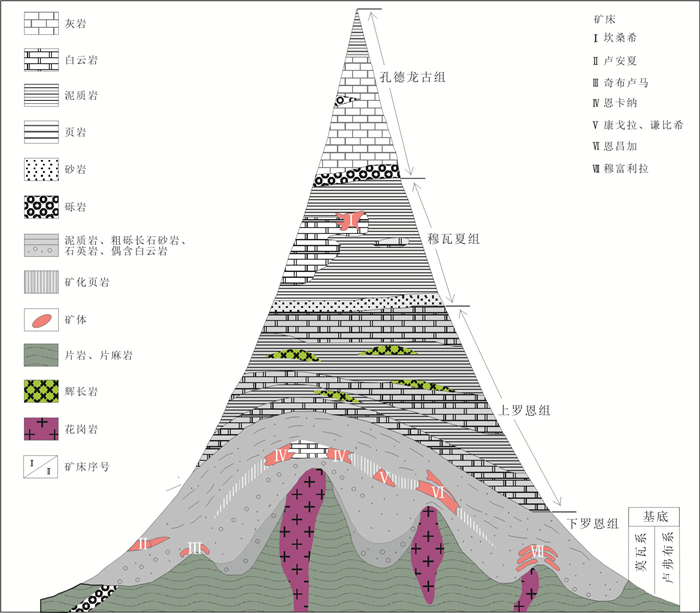
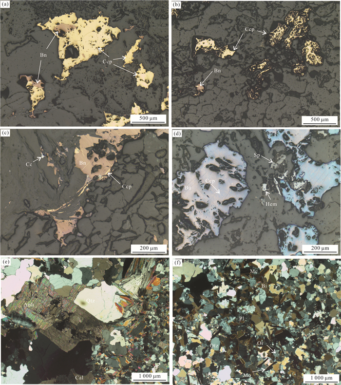
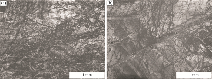
Fluid inclusions study and H-O-S isotopic geochemical analysis of ore and vein minerals were carried out in this study in order to reveal the characteristics of ore-forming fluid and material of the Chambishi copper deposit. The results of microscopic measurement of temperature show that the homogenization temperature and salinity of the fluid inclusions from hydrothermal fluid filling deposit mainly range from 100 to 350 ℃ and 11% to 19% NaCleqv, respectively. Analyses of H-O isotopic composition of the hydrothermal fluid filling deposit show that the values of δDV-SMOW and δ18OH2O are -64.0‰ to -52.6‰ and 1.57‰ to 2.97‰, respectively. Analyses of S isotopic composition show that the values of δ34SCDT from hydrothermal fluid filling orebodies and depositional orebodies are 5.5‰ to 12.1‰ and 6.0‰ to 21.0‰, respectively. The above data indicate that the ore-forming fluid of the hydrothermal fluid filling deposit is of medium-low temperature, low-middle salinity and density, and belongs to Cl-Na-Ca-type aqueous solution. The fluid is a mix of mantle and crust-derived magmas. Fluid mixing is the main reason for copper precipitation. Sulfur of the hydrothermal fluid filling deposit is similar to those of mantle-derived sulfur, whereas the sulfur of the depositional ore deposit is mainly sourced from diagenetic sulphide and seawater sulfate. The mechanism of sulfate reduction for both deposits is thermochemical reduction which resulted in the change of sulfur from SO42- to H2S. The mixed sources of ore-forming fluid and material indicate that mineralization of the hydrothermal fluid filling deposit is closely related to the middle Neoproterozoic magmatism, whereas mineralization of the depositional ore deposit is mainly related to the strong Late Neoproterozoic orogenesis and regional metamorphism.
Fluid inclusions study and H-O-S isotopic geochemical analysis of ore and vein minerals were carried out in this study in order to reveal the characteristics of ore-forming fluid and material of the Chambishi copper deposit. The results of microscopic measurement of temperature show that the homogenization temperature and salinity of the fluid inclusions from hydrothermal fluid filling deposit mainly range from 100 to 350 ℃ and 11% to 19% NaCleqv, respectively. Analyses of H-O isotopic composition of the hydrothermal fluid filling deposit show that the values of δDV-SMOW and δ18OH2O are -64.0‰ to -52.6‰ and 1.57‰ to 2.97‰, respectively. Analyses of S isotopic composition show that the values of δ34SCDT from hydrothermal fluid filling orebodies and depositional orebodies are 5.5‰ to 12.1‰ and 6.0‰ to 21.0‰, respectively. The above data indicate that the ore-forming fluid of the hydrothermal fluid filling deposit is of medium-low temperature, low-middle salinity and density, and belongs to Cl-Na-Ca-type aqueous solution. The fluid is a mix of mantle and crust-derived magmas. Fluid mixing is the main reason for copper precipitation. Sulfur of the hydrothermal fluid filling deposit is similar to those of mantle-derived sulfur, whereas the sulfur of the depositional ore deposit is mainly sourced from diagenetic sulphide and seawater sulfate. The mechanism of sulfate reduction for both deposits is thermochemical reduction which resulted in the change of sulfur from SO42- to H2S. The mixed sources of ore-forming fluid and material indicate that mineralization of the hydrothermal fluid filling deposit is closely related to the middle Neoproterozoic magmatism, whereas mineralization of the depositional ore deposit is mainly related to the strong Late Neoproterozoic orogenesis and regional metamorphism.


2021, 46(5): 1569-1584.
doi: 10.3799/dqkx.2020.358
Abstract:
In order to discuss the genesis of the Shuiwangzhuang gold deposit in Jiaodong Peninsula, S-H-O isotopic compositions of gold-bearing pyrite and quartz were carried out, and the fluid inclusions in quartz during ore-forming period were analyzed in this study. The results show that the δ34S of pyrite ranges from 7.0‰ to 8.5‰, with an average value of 7.7‰. The sulfur may be mainly from mantle sulfur and mixed with a small amount of crust sulfur. The δD of fluid in quartz ranges from -91.7 ‰ to -82.6 ‰, and δ18OH2O ranges from 2.6 ‰ to 5.6 ‰, indicating that the ore-forming fluid is mainly magmatic water, and meteoric water was mixed in at the later stage of mineralization. Three types of fluid inclusions in quartz are recognized during the main metallogenic period, including gas-liquid two-phase fluid inclusions, CO2-bearing fluid inclusions, and liquid rich fluid inclusions with daughter mineral. The salinity of fluid is between 1.2% and 13.8% (NaCleq), and the homogenization temperature is mainly concentrated between 290 and 350 ℃, indicating the main ore-forming fluid is H2O-CO2-NaCl±CH4 system with medium-high temperature and low salinity. The immiscibility (phase separation) or boiling of fluid leads to the precipitation and enrichment of gold. In the Mesozoic, under the influence of the subduction and rollback of the paleo-Pacific plate, large-scale magmatic activities and strong crustal uplift occurred in Jiaodong Peninsula, and the resulting thermal uplift-extensional structure provided favorable conditions for the concentrated mineralization of large-scale gold deposits. In the main detachment fault, the high degree of rock fragmentation is conducive to atmospheric water infiltration, circulation and mixing with deep fluid to form altered rock type gold deposit in fracture zone. In the footwall of main detachment fault, the fracture scale is small and the connectivity with the surface is poor, which is not conducive to the infiltration of meteoric water. The ore-forming fluid is mainly deep-source fluid, forming quartz vein type gold deposit.
In order to discuss the genesis of the Shuiwangzhuang gold deposit in Jiaodong Peninsula, S-H-O isotopic compositions of gold-bearing pyrite and quartz were carried out, and the fluid inclusions in quartz during ore-forming period were analyzed in this study. The results show that the δ34S of pyrite ranges from 7.0‰ to 8.5‰, with an average value of 7.7‰. The sulfur may be mainly from mantle sulfur and mixed with a small amount of crust sulfur. The δD of fluid in quartz ranges from -91.7 ‰ to -82.6 ‰, and δ18OH2O ranges from 2.6 ‰ to 5.6 ‰, indicating that the ore-forming fluid is mainly magmatic water, and meteoric water was mixed in at the later stage of mineralization. Three types of fluid inclusions in quartz are recognized during the main metallogenic period, including gas-liquid two-phase fluid inclusions, CO2-bearing fluid inclusions, and liquid rich fluid inclusions with daughter mineral. The salinity of fluid is between 1.2% and 13.8% (NaCleq), and the homogenization temperature is mainly concentrated between 290 and 350 ℃, indicating the main ore-forming fluid is H2O-CO2-NaCl±CH4 system with medium-high temperature and low salinity. The immiscibility (phase separation) or boiling of fluid leads to the precipitation and enrichment of gold. In the Mesozoic, under the influence of the subduction and rollback of the paleo-Pacific plate, large-scale magmatic activities and strong crustal uplift occurred in Jiaodong Peninsula, and the resulting thermal uplift-extensional structure provided favorable conditions for the concentrated mineralization of large-scale gold deposits. In the main detachment fault, the high degree of rock fragmentation is conducive to atmospheric water infiltration, circulation and mixing with deep fluid to form altered rock type gold deposit in fracture zone. In the footwall of main detachment fault, the fracture scale is small and the connectivity with the surface is poor, which is not conducive to the infiltration of meteoric water. The ore-forming fluid is mainly deep-source fluid, forming quartz vein type gold deposit.


2021, 46(5): 1585-1596.
doi: 10.3799/dqkx.2020.324
Abstract:
Early Cretaceous magmatism in the Liaodong Peninsula is of great significance for the formation of Wulong gold deposit and probably provided the heat source and power for the gold-bearing fluid. Results from geothermobarometry of hornblende-plagioclase applied to the Early Cretaceous Sanguliu and Wulongbei granitoid intrusions,located in the north and south parts of the Wulong area respectively,demonstrate that hornblendes in the Sanguliu and Wulongbei granitoid intrusions crystallized at temperatures from 640.8 to 757.4 ℃ and the emplacement depth of the magma is from 5.9 to 9.7 km. On the TiO2-Al2O3 diagram,samples from the Sanguliu and Wulongbei granitoid intrusions plot in the area of mixed source of crust and mantle. The difference of the emplacement depth between the Sanguliu and Wulongbei granitoid intrusions indicates that the large areas of emergence of the Wulong,Sanguliu and Wulongbei granitoid intrusions were formed by the strong differential exhumation and denudation during the times from late Late Cretaceous to Early Eocene and from Late Eocene to Oligocene. Simultaneously,the gold-bearing veins reached the near surface by regional uplift. The Wulong area is worth further gold exploration considering that the Liaodong Peninsula has the similar tectonic settings with the Jiaodong Peninsula.
Early Cretaceous magmatism in the Liaodong Peninsula is of great significance for the formation of Wulong gold deposit and probably provided the heat source and power for the gold-bearing fluid. Results from geothermobarometry of hornblende-plagioclase applied to the Early Cretaceous Sanguliu and Wulongbei granitoid intrusions,located in the north and south parts of the Wulong area respectively,demonstrate that hornblendes in the Sanguliu and Wulongbei granitoid intrusions crystallized at temperatures from 640.8 to 757.4 ℃ and the emplacement depth of the magma is from 5.9 to 9.7 km. On the TiO2-Al2O3 diagram,samples from the Sanguliu and Wulongbei granitoid intrusions plot in the area of mixed source of crust and mantle. The difference of the emplacement depth between the Sanguliu and Wulongbei granitoid intrusions indicates that the large areas of emergence of the Wulong,Sanguliu and Wulongbei granitoid intrusions were formed by the strong differential exhumation and denudation during the times from late Late Cretaceous to Early Eocene and from Late Eocene to Oligocene. Simultaneously,the gold-bearing veins reached the near surface by regional uplift. The Wulong area is worth further gold exploration considering that the Liaodong Peninsula has the similar tectonic settings with the Jiaodong Peninsula.


2021, 46(5): 1597-1612.
doi: 10.3799/dqkx.2020.157
Abstract:
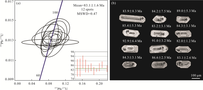
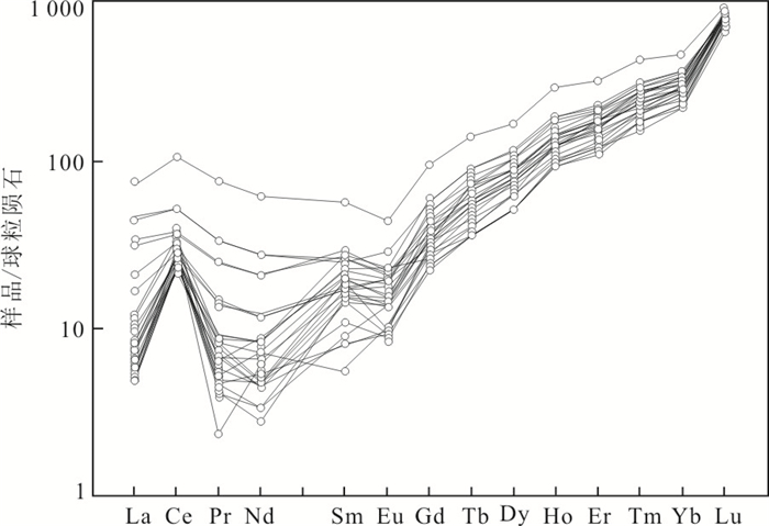
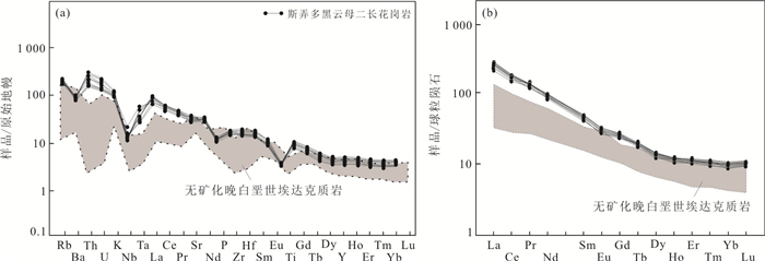
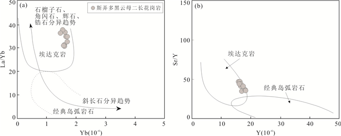
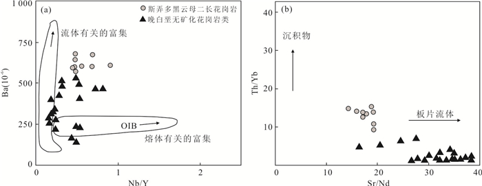
The genesis of the Late Cretaceous adakite in the Gangdese belt, Tibet, has been debated for decades, and research on the productivity of these intrusions is limited. To provide a further understanding of this issue, it presents zircon U-Pb data, geochemical and zircon trace element data of the biotite monzogranite from Sinongduo-Jiaduobu area, Xietongmen County, Tibet. New age data indicate that the biotite monzogranite emplaced in the Late Cretaceous (83.1±1.6 Ma). These rocks are characterized by relatively high contents of SiO2 (60.21%-62.54%), MgO (2.19%-3.02%), Mg# (41.25-50.73), low contents of Y (15.9×10⁻⁶-17.8×10⁻⁶), Yb (1.46×10⁻⁶-1.73×10⁻⁶) and high Sr/Y (35.0-47.6), La/Yb (29.6-38.6) ratios, showing high-SiO2 adakitic rock affinity. These rocks belong to high-K calc-alkaline and metaluminous series (A/CNK=0.84-0.92), and enriched in LREE, LILE (large ion lithophile element) and depleted in HREE, HFSE (high field strength element), such as Nb and Ta. The zircon trace element data show high V/Sc, Ce/Ce*, 10 000×(Eu/Eu*), and moderate Eu/Eu* ratios. By comparing with typical adakitic rocks from the Gangdese belt, it is proposed that these rocks with high oxygen fugacity were derived from the partial melting of subducted Neo-Tethyan slab, and have good potential for Cu-Au mineralization.
The genesis of the Late Cretaceous adakite in the Gangdese belt, Tibet, has been debated for decades, and research on the productivity of these intrusions is limited. To provide a further understanding of this issue, it presents zircon U-Pb data, geochemical and zircon trace element data of the biotite monzogranite from Sinongduo-Jiaduobu area, Xietongmen County, Tibet. New age data indicate that the biotite monzogranite emplaced in the Late Cretaceous (83.1±1.6 Ma). These rocks are characterized by relatively high contents of SiO2 (60.21%-62.54%), MgO (2.19%-3.02%), Mg# (41.25-50.73), low contents of Y (15.9×10⁻⁶-17.8×10⁻⁶), Yb (1.46×10⁻⁶-1.73×10⁻⁶) and high Sr/Y (35.0-47.6), La/Yb (29.6-38.6) ratios, showing high-SiO2 adakitic rock affinity. These rocks belong to high-K calc-alkaline and metaluminous series (A/CNK=0.84-0.92), and enriched in LREE, LILE (large ion lithophile element) and depleted in HREE, HFSE (high field strength element), such as Nb and Ta. The zircon trace element data show high V/Sc, Ce/Ce*, 10 000×(Eu/Eu*), and moderate Eu/Eu* ratios. By comparing with typical adakitic rocks from the Gangdese belt, it is proposed that these rocks with high oxygen fugacity were derived from the partial melting of subducted Neo-Tethyan slab, and have good potential for Cu-Au mineralization.


2021, 46(5): 1613-1629.
doi: 10.3799/dqkx.2020.198
Abstract:
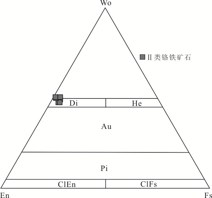
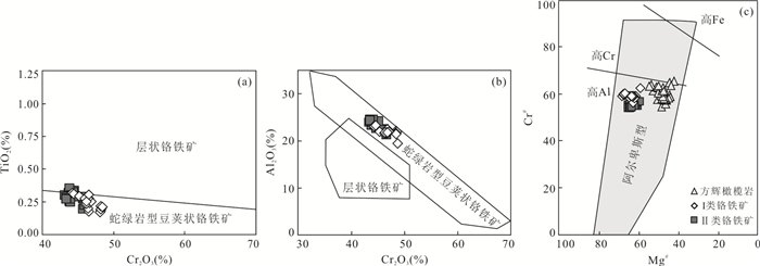
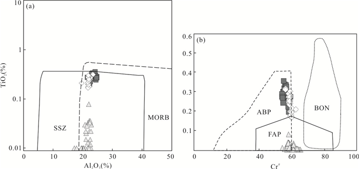
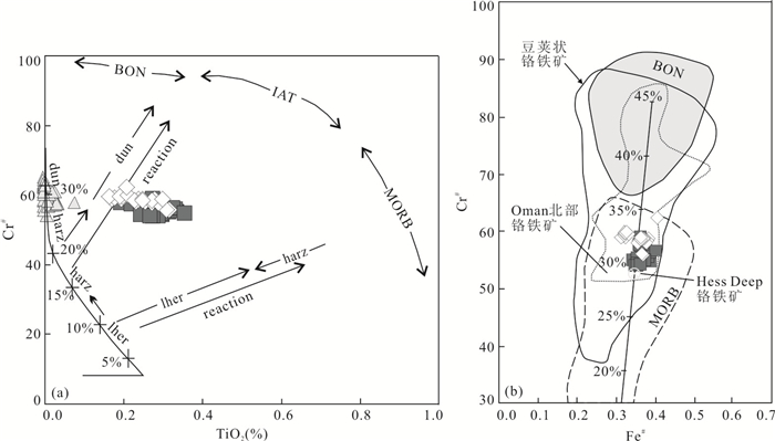
South Anhui ophiolite, one of the oldest ophiolites in southern China, is located in the northeastern most segment of Jiangnan orogen. The ultramafic rocks in this area are extensively serpentinized which constrains the researches here and it is challenging for further studies. In order to investigate the origin of the South Anhui ophiolites and the Fuchuan chromitites, detailed observation with microscope and electron probe micro-analyzer was made for the mineralogy analysis of chromites and paragenetic minerals in harzburgites and chromitites. The chromites can be divided into two types, namely, type Ⅰ with kämmererite as the gangue mineral, and type Ⅱ with diallage as the gangue mineral. All the chromites are typical Alpine-type high aluminum chromites, most of which develop fractures, and along the rim and fractures are altered into ferritchromite. The unaltered core part of the chromites which retains the pristine composition was studied, and the spinels in harzburgites are characterized by moderate Cr# (100×Cr/(Cr+Al), 54.12-65.18) and low Mg# (100×Mg/(Mg+Fe2+), 42.37-54.84), and those of the chromites from the chromitites are 53.97-62.29 and 59.49-68.57, respectively. The calculated component of parental melts of the chromitites is similar to MORB (mid-ocean ridge basalt), indicating the derivation from MORB. The oxygen fugacity is low (-0.14 to +0.68log(QFM)), showing the feature of transition from MORB to SSZ (suprasubduction zone) setting. Combining with the field phenomena, it is believed that chromitites might be formed from the interaction of peridotites and MORB, and together with the SSZ feature of the harzburgites, reflecting that the formation of South Anhui ophiolites might be the result of the combined effect of partial melting of the peridotites, rock-melt interaction, and plate subduction, which provides vital evidence for the tectonic and evolution of the Jiangnan orogen.
South Anhui ophiolite, one of the oldest ophiolites in southern China, is located in the northeastern most segment of Jiangnan orogen. The ultramafic rocks in this area are extensively serpentinized which constrains the researches here and it is challenging for further studies. In order to investigate the origin of the South Anhui ophiolites and the Fuchuan chromitites, detailed observation with microscope and electron probe micro-analyzer was made for the mineralogy analysis of chromites and paragenetic minerals in harzburgites and chromitites. The chromites can be divided into two types, namely, type Ⅰ with kämmererite as the gangue mineral, and type Ⅱ with diallage as the gangue mineral. All the chromites are typical Alpine-type high aluminum chromites, most of which develop fractures, and along the rim and fractures are altered into ferritchromite. The unaltered core part of the chromites which retains the pristine composition was studied, and the spinels in harzburgites are characterized by moderate Cr# (100×Cr/(Cr+Al), 54.12-65.18) and low Mg# (100×Mg/(Mg+Fe2+), 42.37-54.84), and those of the chromites from the chromitites are 53.97-62.29 and 59.49-68.57, respectively. The calculated component of parental melts of the chromitites is similar to MORB (mid-ocean ridge basalt), indicating the derivation from MORB. The oxygen fugacity is low (-0.14 to +0.68log(QFM)), showing the feature of transition from MORB to SSZ (suprasubduction zone) setting. Combining with the field phenomena, it is believed that chromitites might be formed from the interaction of peridotites and MORB, and together with the SSZ feature of the harzburgites, reflecting that the formation of South Anhui ophiolites might be the result of the combined effect of partial melting of the peridotites, rock-melt interaction, and plate subduction, which provides vital evidence for the tectonic and evolution of the Jiangnan orogen.


2021, 46(5): 1630-1643.
doi: 10.3799/dqkx.2020.169
Abstract:
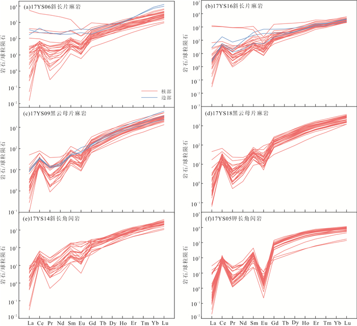
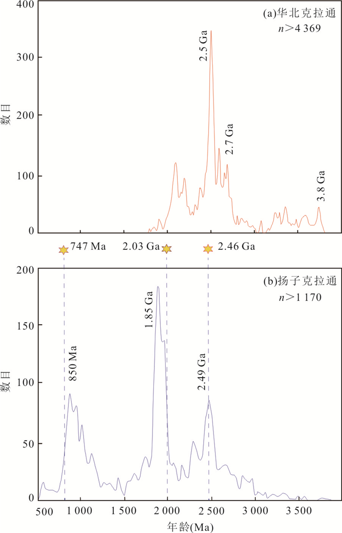
Archean-Paleoproterozoic basement is widespread in the Yangtze craton. However, many essential problems about the formation and evolution of the Precambrian basement of the Yangtze craton are still open, especially whether the basement of the Yangtze craton is coherent or composed of multiple blocks. A geochronological and geochemical study was carried out for the felsic gneiss, amphibolite and intrusive granite from the Feidong complex in the Zhangbaling uplift at the northern margin of the Yangtze craton. Zircon U-Pb dating gives similar protolith ages of 2 449±17 Ma, 2 444±15 Ma, 2 495±23 Ma and 2 478±24 Ma for the felsic gneisses. The ages of the amphibolite and A-type granite are 2 032±35 Ma and 747±4 Ma, respectively. This indicates that the Late Archean-Paleoproterozoic crystalline basement of the Yangtze craton cropped out in this area. The zircon εHf(t) values of the ca. 2.45-2.50 Ga gneisses are negative with an average value of -3.6±0.5 and the corresponding two-stage Hf model ages (TDM2) range from 3.3 to 3.0 Ga with an average of 3 185±31 Ma, which shows that the 2.45-2.50 Ga magmatic event is mainly the reworking of Paleo-Mesoarchean crust. The occurrence of similar magmatic rocks in other terranes, including the Yudongzi Group and Douling complex in the northern Yangtze craton, as well as detrital zircons and volcanic xenocrystals with similar ages widespread in the Yangtze craton, suggests that the basement is coherent throughout the whole Yangtze craton.
Archean-Paleoproterozoic basement is widespread in the Yangtze craton. However, many essential problems about the formation and evolution of the Precambrian basement of the Yangtze craton are still open, especially whether the basement of the Yangtze craton is coherent or composed of multiple blocks. A geochronological and geochemical study was carried out for the felsic gneiss, amphibolite and intrusive granite from the Feidong complex in the Zhangbaling uplift at the northern margin of the Yangtze craton. Zircon U-Pb dating gives similar protolith ages of 2 449±17 Ma, 2 444±15 Ma, 2 495±23 Ma and 2 478±24 Ma for the felsic gneisses. The ages of the amphibolite and A-type granite are 2 032±35 Ma and 747±4 Ma, respectively. This indicates that the Late Archean-Paleoproterozoic crystalline basement of the Yangtze craton cropped out in this area. The zircon εHf(t) values of the ca. 2.45-2.50 Ga gneisses are negative with an average value of -3.6±0.5 and the corresponding two-stage Hf model ages (TDM2) range from 3.3 to 3.0 Ga with an average of 3 185±31 Ma, which shows that the 2.45-2.50 Ga magmatic event is mainly the reworking of Paleo-Mesoarchean crust. The occurrence of similar magmatic rocks in other terranes, including the Yudongzi Group and Douling complex in the northern Yangtze craton, as well as detrital zircons and volcanic xenocrystals with similar ages widespread in the Yangtze craton, suggests that the basement is coherent throughout the whole Yangtze craton.


2021, 46(5): 1644-1656.
doi: 10.3799/dqkx.2020.176
Abstract:
The spatial relationship and tectonic affinity of the ophiolite can provide key evidence for the evolution of the subduction zone and paleo-tectonic reconstruction. Ophiolite in Shuidongxia is an important part of the southern belt of the North Qilian orogen, however, the age and tectonic setting are poorly constrained. Zircon grains from the gabbro yield a weighted mean 206Pb/238U age 497.0±2.4 Ma (MSWD=0.84), indicating the Shuidongxia ophiolite formed in the Late Cambrian, which is consistent with the ages of ophiolites in the southern belt of the North Qilian orogen. The mineralogical characteristics as well as the whole-rock geochemistry of gabbro, serpentinite and basalt suggest that the Shuidongxia ophiolites are closely related to subduction zone. Combined with the regional geology of the North Qilian orogen, it is suggested that the Yushigou-Shuidongxia ophiolite belongs to SSZ-type and obducted southward onto the central Qilian block during the arc-continent collision.
The spatial relationship and tectonic affinity of the ophiolite can provide key evidence for the evolution of the subduction zone and paleo-tectonic reconstruction. Ophiolite in Shuidongxia is an important part of the southern belt of the North Qilian orogen, however, the age and tectonic setting are poorly constrained. Zircon grains from the gabbro yield a weighted mean 206Pb/238U age 497.0±2.4 Ma (MSWD=0.84), indicating the Shuidongxia ophiolite formed in the Late Cambrian, which is consistent with the ages of ophiolites in the southern belt of the North Qilian orogen. The mineralogical characteristics as well as the whole-rock geochemistry of gabbro, serpentinite and basalt suggest that the Shuidongxia ophiolites are closely related to subduction zone. Combined with the regional geology of the North Qilian orogen, it is suggested that the Yushigou-Shuidongxia ophiolite belongs to SSZ-type and obducted southward onto the central Qilian block during the arc-continent collision.


2021, 46(5): 1657-1676.
doi: 10.3799/dqkx.2020.147
Abstract:
A series of tectonic association of the thrust nappe structure and the extensional tectonics are widely developed in the West Hill of Beijing, which are very important for understanding the tectonic evolution of the eastern part of North China craton (NCC). However, their deformed age, tectonic dynamic background and genetic mechanism are poorly understood. The Nanguan area in the West Hill of Beijing is an ideal place to decipher such a tectonic pattern. The detailed field structure observations show a tectonic association of the thrust nappe structure and the metamorphic core complex structure in the Nanguan area, generating a new type of tectonic pattern: the downward diapiric tectonics. It has the following characteristics: (1) wedge-shaped fold-fault structure with a normal fault along one side of the fold and a thrust fault along another side; (2) the fold (overturned syncline) is centered and both sides are older strata or basements, and (3) downward diapiric structure of the wedge-shaped body. Pudding-shaped lens of granitic and dioritic dykes were found in the thrust nappe. The granitic and dioritic lens give two weighted zircon U-Pb age of 141±2 Ma and 139±2 Ma, respectively. The previous studies suggest that a quartz monozite, which intruded into the thrust nappe, has zircon U-Pb age of 128-136 Ma. Thus, the deformation time of the thrust nappe is between ca. 140 and 130 Ma, which is a little earlier than or nearly coeval with the extensional tectonics represented by the metamorphic core complex structure. The orientation of the thrust nappe structure was generally W320°-335°N. The principal stress orientation of the extensional tectonics was also SE-NW trending. Thus, the tectonic pattern of compression-magmatism-extension in the West Hill of Beijing (and even in the eastern part of NCC) might be closely related to SE-NW-trending subduction of the Pacific plate. The tectonic pattern also might be an expression to the destroy or lithospheric thinning of the NCC.
A series of tectonic association of the thrust nappe structure and the extensional tectonics are widely developed in the West Hill of Beijing, which are very important for understanding the tectonic evolution of the eastern part of North China craton (NCC). However, their deformed age, tectonic dynamic background and genetic mechanism are poorly understood. The Nanguan area in the West Hill of Beijing is an ideal place to decipher such a tectonic pattern. The detailed field structure observations show a tectonic association of the thrust nappe structure and the metamorphic core complex structure in the Nanguan area, generating a new type of tectonic pattern: the downward diapiric tectonics. It has the following characteristics: (1) wedge-shaped fold-fault structure with a normal fault along one side of the fold and a thrust fault along another side; (2) the fold (overturned syncline) is centered and both sides are older strata or basements, and (3) downward diapiric structure of the wedge-shaped body. Pudding-shaped lens of granitic and dioritic dykes were found in the thrust nappe. The granitic and dioritic lens give two weighted zircon U-Pb age of 141±2 Ma and 139±2 Ma, respectively. The previous studies suggest that a quartz monozite, which intruded into the thrust nappe, has zircon U-Pb age of 128-136 Ma. Thus, the deformation time of the thrust nappe is between ca. 140 and 130 Ma, which is a little earlier than or nearly coeval with the extensional tectonics represented by the metamorphic core complex structure. The orientation of the thrust nappe structure was generally W320°-335°N. The principal stress orientation of the extensional tectonics was also SE-NW trending. Thus, the tectonic pattern of compression-magmatism-extension in the West Hill of Beijing (and even in the eastern part of NCC) might be closely related to SE-NW-trending subduction of the Pacific plate. The tectonic pattern also might be an expression to the destroy or lithospheric thinning of the NCC.


2021, 46(5): 1677-1691.
doi: 10.3799/dqkx.2020.115
Abstract:
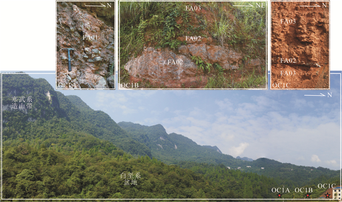
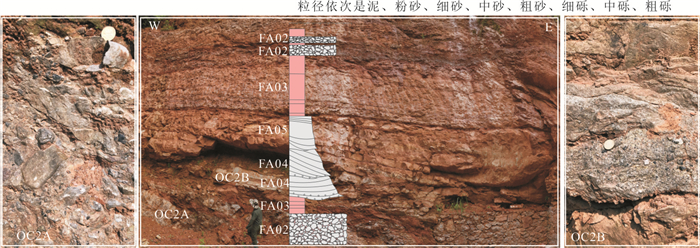
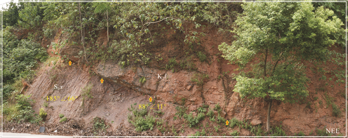
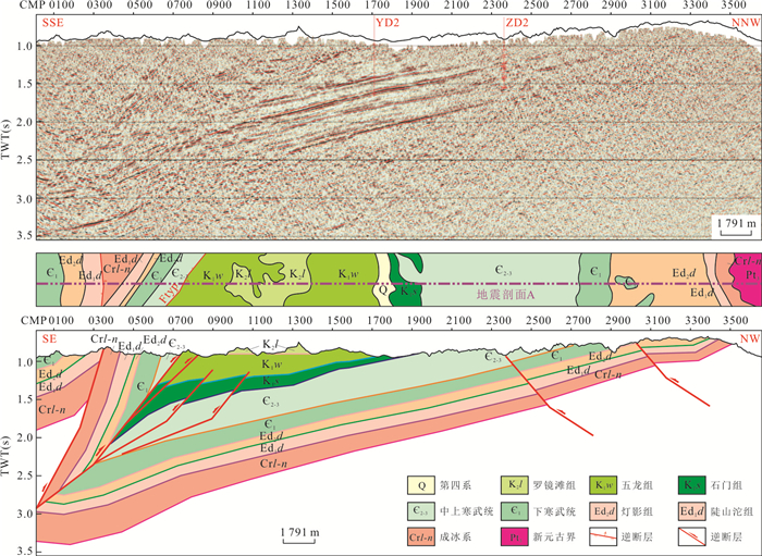
The residual Cretaceous basin of the Yichang slope is a window to understand the Cretaceous tectonic evolution of the Middle Yangtze block. Based on the observation of tectonic-sedimentary features of the Cretaceous outcrops and combined with the tectonic-stratigraphic interpretation of two-dimensional seismic profiles, the tectonic properties and sedimentary filling of the Cretaceous basin of Yichang slope are identified, and the compressional rift-sag structure of the Cretaceous intracontinental compressional basin is established. The Cretaceous basin of Yichang slope was an intracontinental compressional basin controlled by Tianyangping thrust fault zone. The Lower Cretaceous basin was a compressional rift that had developed during synorogenic period, which was filled with fan delta-lacustrine sedimentary systems, and the Upper Cretaceous basin was a compressional sag that had developed during post-orogenic period and was filled with alluvial fan-braided river-aeolian-shallow lacustrine sedimentary systems. The Upper Cretaceous basin of the Yichang slope and western Hunan-Hubei arcuate fold-thrust belts belong to the compressional sag of the intracontinental compressional basin, which reveals that the initial time of the transition from compressional to extensional tectonic regime in the Middle Yangtze block should be at the Cenozoic.
The residual Cretaceous basin of the Yichang slope is a window to understand the Cretaceous tectonic evolution of the Middle Yangtze block. Based on the observation of tectonic-sedimentary features of the Cretaceous outcrops and combined with the tectonic-stratigraphic interpretation of two-dimensional seismic profiles, the tectonic properties and sedimentary filling of the Cretaceous basin of Yichang slope are identified, and the compressional rift-sag structure of the Cretaceous intracontinental compressional basin is established. The Cretaceous basin of Yichang slope was an intracontinental compressional basin controlled by Tianyangping thrust fault zone. The Lower Cretaceous basin was a compressional rift that had developed during synorogenic period, which was filled with fan delta-lacustrine sedimentary systems, and the Upper Cretaceous basin was a compressional sag that had developed during post-orogenic period and was filled with alluvial fan-braided river-aeolian-shallow lacustrine sedimentary systems. The Upper Cretaceous basin of the Yichang slope and western Hunan-Hubei arcuate fold-thrust belts belong to the compressional sag of the intracontinental compressional basin, which reveals that the initial time of the transition from compressional to extensional tectonic regime in the Middle Yangtze block should be at the Cenozoic.


2021, 46(5): 1692-1709.
doi: 10.3799/dqkx.2020.118
Abstract:
The Yanshanian movement was a major tectonic movement on a regional and lithospheric scale at the turn of the Jurassic to Cretaceous, which laid the foundation of tectonics in China. Compared with eastern China, there are still many controversies on the magmatism, tectonic dynamic mechanism and sedimentary response of the Yanshanian movement in the western China basin. In this study, the Yanshanian tectonic movement and sedimentary response of the basin are discussed based on the clastic zircon chronology and sandstone lithofacies of the Late Jurassic-Early Cretaceous sandstone samples in the Shinan area of the Junggar basin. The main conclusions can be drawn as follows. (1) Age of syndepositional volcanism recorded by the detrital zircons derived from magmatic rocks in the southern margin and northern part of the Junggar basin effectively indicates the existence of regional volcanism in the Late Jurassic-Early Cretaceous. (2) Intense intracontinental orogeny in the Yanshanian period led to extrusion deformation of tectonic units in the Junggar basin. (3) The sedimentary system had a good response to the Yanshanian tectonic movement. Cretaceous conglomerates indicate the rapid uplift of the orogenic belt around the basin and the shrinkage of the basin boundary.
The Yanshanian movement was a major tectonic movement on a regional and lithospheric scale at the turn of the Jurassic to Cretaceous, which laid the foundation of tectonics in China. Compared with eastern China, there are still many controversies on the magmatism, tectonic dynamic mechanism and sedimentary response of the Yanshanian movement in the western China basin. In this study, the Yanshanian tectonic movement and sedimentary response of the basin are discussed based on the clastic zircon chronology and sandstone lithofacies of the Late Jurassic-Early Cretaceous sandstone samples in the Shinan area of the Junggar basin. The main conclusions can be drawn as follows. (1) Age of syndepositional volcanism recorded by the detrital zircons derived from magmatic rocks in the southern margin and northern part of the Junggar basin effectively indicates the existence of regional volcanism in the Late Jurassic-Early Cretaceous. (2) Intense intracontinental orogeny in the Yanshanian period led to extrusion deformation of tectonic units in the Junggar basin. (3) The sedimentary system had a good response to the Yanshanian tectonic movement. Cretaceous conglomerates indicate the rapid uplift of the orogenic belt around the basin and the shrinkage of the basin boundary.


2021, 46(5): 1710-1727.
doi: 10.3799/dqkx.2020.206
Abstract:
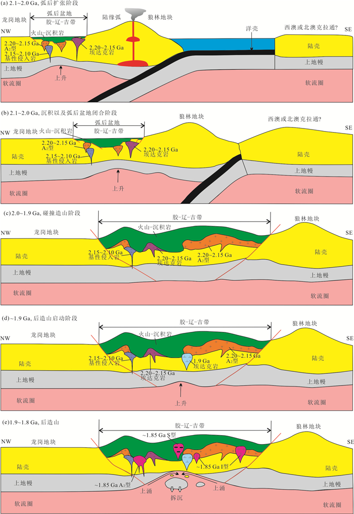
Liaoji granitoids are important constituents of the Jiao-Liao-Ji belt (JLJB), and they provide important constraints on tectonic setting of the JLJB. The tectonic setting of the JLJB is still controversial due to the debate on nature of the Liaoji granitoids. It conducted zircon U-Pb geochronological and geochemical analyses of Liaoji granitoids (Muniuhe and Dafangshen plutons) in the Muniuhe-Dafangshen area, and then discuss the petrogenesis and geological significance of these granitoids. LA-ICP-MS U-Pb zircon dating gives the emplacement age of 2 176±4 Ma and 2 179±4 Ma for Muniuhe and Dafangshen plutons, respectively. Muniuhe and Dafangshen granitoids display similar geochemical characteristics. They have high SiO2 (72.85%-77.67%), alkalis (K2O+Na2O=7.65%-8.86%) and K2O/Na2O ratios (0.99-1.83), and low CaO (0.10%-0.92%), MgO (0.03%-0.09%) and Al2O3 (11.49%-12.67%) contents. The chondrite-normalized REE patterns of Muniuhe and Dafangshen granitoids show right-dipping linear trends with slightly negative Eu anomalies (Eu/Eu*=0.08-0.56) and high Ga/Al ratios. They are enriched in high field strength elements (HFSEs; e.g., Zr, U and Y) and large-ion lithophile elements (LILEs; e.g., Rb and K), and depleted in Nb, P, Ti and Sr. In addition, they display high Zr saturation temperatures (855-871 ℃ and 850-886 ℃, repectively). Low Nb/Y ratios and high Zr saturation temperatures indicate that the Muniuhe and Dafangshen granitoids have affinities with A2-subtype granitoids, and they were derived from thinned lower crust. The occurrence of voluminous A2-subtype granitoids, combined with the newly discovered Na-rich granitoids and calc-alkaline mafic rocks, suggests that the tectonic setting of the JLJB is back-arc basin.
Liaoji granitoids are important constituents of the Jiao-Liao-Ji belt (JLJB), and they provide important constraints on tectonic setting of the JLJB. The tectonic setting of the JLJB is still controversial due to the debate on nature of the Liaoji granitoids. It conducted zircon U-Pb geochronological and geochemical analyses of Liaoji granitoids (Muniuhe and Dafangshen plutons) in the Muniuhe-Dafangshen area, and then discuss the petrogenesis and geological significance of these granitoids. LA-ICP-MS U-Pb zircon dating gives the emplacement age of 2 176±4 Ma and 2 179±4 Ma for Muniuhe and Dafangshen plutons, respectively. Muniuhe and Dafangshen granitoids display similar geochemical characteristics. They have high SiO2 (72.85%-77.67%), alkalis (K2O+Na2O=7.65%-8.86%) and K2O/Na2O ratios (0.99-1.83), and low CaO (0.10%-0.92%), MgO (0.03%-0.09%) and Al2O3 (11.49%-12.67%) contents. The chondrite-normalized REE patterns of Muniuhe and Dafangshen granitoids show right-dipping linear trends with slightly negative Eu anomalies (Eu/Eu*=0.08-0.56) and high Ga/Al ratios. They are enriched in high field strength elements (HFSEs; e.g., Zr, U and Y) and large-ion lithophile elements (LILEs; e.g., Rb and K), and depleted in Nb, P, Ti and Sr. In addition, they display high Zr saturation temperatures (855-871 ℃ and 850-886 ℃, repectively). Low Nb/Y ratios and high Zr saturation temperatures indicate that the Muniuhe and Dafangshen granitoids have affinities with A2-subtype granitoids, and they were derived from thinned lower crust. The occurrence of voluminous A2-subtype granitoids, combined with the newly discovered Na-rich granitoids and calc-alkaline mafic rocks, suggests that the tectonic setting of the JLJB is back-arc basin.


2021, 46(5): 1728-1736.
doi: 10.3799/dqkx.2020.017
Abstract:
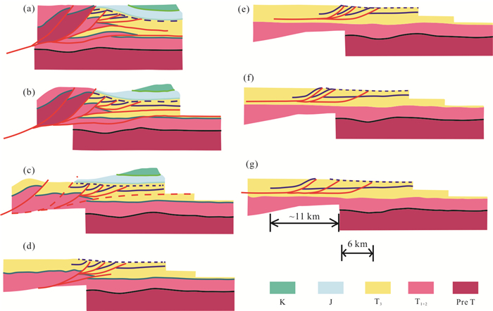
It is wildly shared that the western Sichuan basin changed from passive continental margin to a foreland basin during the Late Triassic. In order to depict this transition process as well as the time and intensity of the tectonic activity of Longmenshan thrust belt during Late Indosinian, a seismic section in the middle part of Longmenshan thrust belt was used to perform structural geometric analysis. The results show that the large scale thrusting of Longmenshan probably occurred during the early stage of the deposition time of T3x4 and the total displacement was at least 11 km. This is also supported by the sedimentary record of the detrital zircon U-Pb age from the synchrous strata. The major age peak of ~800 Ma shows great affinity to the Pengguan complex and Baoxing complex from the middle section of Longmenshan belt. It is concluded that the basement in the middle part of Longmenshan belt was uplifted partly during T3x3 and provided materials for the western Sichuan basin.
It is wildly shared that the western Sichuan basin changed from passive continental margin to a foreland basin during the Late Triassic. In order to depict this transition process as well as the time and intensity of the tectonic activity of Longmenshan thrust belt during Late Indosinian, a seismic section in the middle part of Longmenshan thrust belt was used to perform structural geometric analysis. The results show that the large scale thrusting of Longmenshan probably occurred during the early stage of the deposition time of T3x4 and the total displacement was at least 11 km. This is also supported by the sedimentary record of the detrital zircon U-Pb age from the synchrous strata. The major age peak of ~800 Ma shows great affinity to the Pengguan complex and Baoxing complex from the middle section of Longmenshan belt. It is concluded that the basement in the middle part of Longmenshan belt was uplifted partly during T3x3 and provided materials for the western Sichuan basin.


2021, 46(5): 1737-1748.
doi: 10.3799/dqkx.2020.020
Abstract:
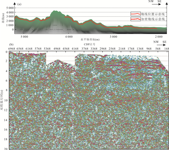
Pengguan complex is located in the middle part of Longmenshan fault zone, which is an important part of Longmenshan regional tectonics. In this paper, the deep seismic reflection profile through the long axis of Pengguan complex is analyzed and interpreted, and the deep structural characteristics and formation mechanism of Pengguan complex are described. The analysis of seismic reflection profile shows that Pengguan complex is stratified in depth, with a bottom interface, and Pengguan complex shows rootless characteristics. Based on the analysis of its structural characteristics, it can be inferred that the in-situ rocks come from deeper and more western locations. The development of faults in the shallow part of Pengguan complex is consistent with the surface fault system of Longmenshan Mountain, which indicates that the diagenesis time of Pengguan complex is earlier than that of Longmenshan tectonic movement. At the same time, the Yingxiu-Beichuan fault in the deep part of the section energy map develops stratified gaps in different stages of Pengguan complex rock mass, which means it did not destroy the deep structure of Pengguan complex main rock mass. Referring to lithology and diagenetic time, it is inferred that Pengguan complex originated from the Songpan block basement material which was upwelled by compression during the Indosinian movement, the basement magma upwelled several times during the plate movement, and was uplifted by stress nappe in the northwest direction during the Himalayan movement to its present position.
Pengguan complex is located in the middle part of Longmenshan fault zone, which is an important part of Longmenshan regional tectonics. In this paper, the deep seismic reflection profile through the long axis of Pengguan complex is analyzed and interpreted, and the deep structural characteristics and formation mechanism of Pengguan complex are described. The analysis of seismic reflection profile shows that Pengguan complex is stratified in depth, with a bottom interface, and Pengguan complex shows rootless characteristics. Based on the analysis of its structural characteristics, it can be inferred that the in-situ rocks come from deeper and more western locations. The development of faults in the shallow part of Pengguan complex is consistent with the surface fault system of Longmenshan Mountain, which indicates that the diagenesis time of Pengguan complex is earlier than that of Longmenshan tectonic movement. At the same time, the Yingxiu-Beichuan fault in the deep part of the section energy map develops stratified gaps in different stages of Pengguan complex rock mass, which means it did not destroy the deep structure of Pengguan complex main rock mass. Referring to lithology and diagenetic time, it is inferred that Pengguan complex originated from the Songpan block basement material which was upwelled by compression during the Indosinian movement, the basement magma upwelled several times during the plate movement, and was uplifted by stress nappe in the northwest direction during the Himalayan movement to its present position.


2021, 46(5): 1749-1757.
doi: 10.3799/dqkx.2020.137
Abstract:
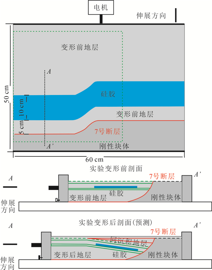
In order to discuss the influence of plastic layer on the structural pattern and fault characteristics in the process of extensional structural inversion, Two sets of extensional sandbox models with different physical properties are designed. Experiment results indicate that the existence of plastic formation in relatively pure quartz sandstone areas leads to the earlier occurrence time of fault, and larger fault distance and extension length under the action of the same extension stress. In the process of extension and inversion, the existence of plastic strata can change the structural pattern of faults, and it is easier to form plastic detachment faults, which plays two main roles. (1) The scale of faults in the upper part of the plastic layer is relatively large, while that in the upper part of the brittle layer tends to form multiple faults with relatively small scale. (2) The number and scale of the faults in the upper part of the plastic layer with opposite tendency to the boundary detachment faults are obviously larger than those with the same tendency, which shows that the plastic layer can restrain the faults with the same tendency as the boundary detachment faults. Therefore, compared with the eastern area of Wushi depression, the existence of plastic strata has a great influence on the characteristics of the development of extensional reverse structural faults, which can provide the necessary theoretical basis for the later oil and gas exploration.
In order to discuss the influence of plastic layer on the structural pattern and fault characteristics in the process of extensional structural inversion, Two sets of extensional sandbox models with different physical properties are designed. Experiment results indicate that the existence of plastic formation in relatively pure quartz sandstone areas leads to the earlier occurrence time of fault, and larger fault distance and extension length under the action of the same extension stress. In the process of extension and inversion, the existence of plastic strata can change the structural pattern of faults, and it is easier to form plastic detachment faults, which plays two main roles. (1) The scale of faults in the upper part of the plastic layer is relatively large, while that in the upper part of the brittle layer tends to form multiple faults with relatively small scale. (2) The number and scale of the faults in the upper part of the plastic layer with opposite tendency to the boundary detachment faults are obviously larger than those with the same tendency, which shows that the plastic layer can restrain the faults with the same tendency as the boundary detachment faults. Therefore, compared with the eastern area of Wushi depression, the existence of plastic strata has a great influence on the characteristics of the development of extensional reverse structural faults, which can provide the necessary theoretical basis for the later oil and gas exploration.


2021, 46(5): 1758-1770.
doi: 10.3799/dqkx.2021.011
Abstract:
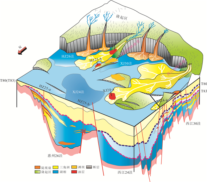
In view of the theory and application of sequence stratigraphy in the marine deltaic facies, in this paper it selects the Lower-Middle Miocene (T50-T35) acient Pearl River delta in the north of the Enping sag, Pearl River Mouth basin as the target to carry out detailed anatomy. On the basis of digesting and absorbing the latest development of "depositional sequence" theory, combined with the development characteristics of ancient Pearl River delta and well seismic data conditions, a high-frequency sequence stratigraphic scheme is proposed on the basis of four types of surfaces, namely the sequence boundary (SB), maximum regressive surface (MRS), maximum flooding surface (MFS) and high-order flooding surface (FS). The results reveal that the most striking feature of the sequence stratigraphy of this area is the extensive development of the lowstand systems tracts. Constrained by the high-resolution sequence framework, the seismic sedimentology technology is further used to carry out the fine sedimentary analysis. The results show that the lowstand systems tracts in the study area are mainly composed of large intersecting braided channels, with large thickness and continuous distribution of sand bodies. In contrast, the sand content of transgressive and highstand systems tracts is obviously lower, with sinuous, low-energy river channel or shore-parallel bars as the main body, signifying greater lithologic traps potential. In addition, combined with the results of sequence architecture classification, it is proposed that the sixth member of Hanjiang Formation and the first member of Zhujiang Formation, which are dominated by A-type sequence architecture (highstand systems tracts dominated), have great lithologic trap potential. The conclusions of this study have certain guiding significance for the exploration of lithologic traps in the Pearl River Mouth basin and other marine basins.
In view of the theory and application of sequence stratigraphy in the marine deltaic facies, in this paper it selects the Lower-Middle Miocene (T50-T35) acient Pearl River delta in the north of the Enping sag, Pearl River Mouth basin as the target to carry out detailed anatomy. On the basis of digesting and absorbing the latest development of "depositional sequence" theory, combined with the development characteristics of ancient Pearl River delta and well seismic data conditions, a high-frequency sequence stratigraphic scheme is proposed on the basis of four types of surfaces, namely the sequence boundary (SB), maximum regressive surface (MRS), maximum flooding surface (MFS) and high-order flooding surface (FS). The results reveal that the most striking feature of the sequence stratigraphy of this area is the extensive development of the lowstand systems tracts. Constrained by the high-resolution sequence framework, the seismic sedimentology technology is further used to carry out the fine sedimentary analysis. The results show that the lowstand systems tracts in the study area are mainly composed of large intersecting braided channels, with large thickness and continuous distribution of sand bodies. In contrast, the sand content of transgressive and highstand systems tracts is obviously lower, with sinuous, low-energy river channel or shore-parallel bars as the main body, signifying greater lithologic traps potential. In addition, combined with the results of sequence architecture classification, it is proposed that the sixth member of Hanjiang Formation and the first member of Zhujiang Formation, which are dominated by A-type sequence architecture (highstand systems tracts dominated), have great lithologic trap potential. The conclusions of this study have certain guiding significance for the exploration of lithologic traps in the Pearl River Mouth basin and other marine basins.


2021, 46(5): 1771-1782.
doi: 10.3799/dqkx.2020.178
Abstract:
By an integrated investigation of the sedimentary system and the seasonal variation of lake shoreline of the modern Poyang Lake basin, combined with the analyses of sedimentary lithologies, sedimentary sequences, and sedimentary structures of the Neogene Guantao Formation in the Bodong area of the Bohai Bay basin, it proposes a river-lake interaction sedimentary model for continental shallow-water lacustrine basins. Based on the analysis of lake level variations caused by seasonal changes of the Poyang Lake, the flood, static water and low water levels were identified. The Poyang Lake is divided into three sedimentary segments: a river-dominated area (Area A), a river-lake interaction area (Area B) and a lake-dominated area (Area C).Channel-shaped sands are mainly distributed in Area A with distinct skeleton drainage patterns, lobate-shaped sands are developed in Area B which is characterized by intensive water body separation, and lacustrine mudstone and sheet-like sands are developed in Area C and are typically separated by several sub-depocenters. The established sedimentary model of river-lake interaction was applied to interpret the shallow-water Neogene Guantao Formation in the ancient lacustrine basin of the Bodong area, and to effectively subdivide and analyze the sedimentary characteristics of river-lake interaction units in the study area. The river-lake interactional sedimentary model under the shallow-water environment may be used as a reference for sedimentary type identification and sand-body prediction within the same shallow-water environment ranging from continental down-warped lacustrine basin, cratonic basins to the gentle-slope belt of fault-depression basin.
By an integrated investigation of the sedimentary system and the seasonal variation of lake shoreline of the modern Poyang Lake basin, combined with the analyses of sedimentary lithologies, sedimentary sequences, and sedimentary structures of the Neogene Guantao Formation in the Bodong area of the Bohai Bay basin, it proposes a river-lake interaction sedimentary model for continental shallow-water lacustrine basins. Based on the analysis of lake level variations caused by seasonal changes of the Poyang Lake, the flood, static water and low water levels were identified. The Poyang Lake is divided into three sedimentary segments: a river-dominated area (Area A), a river-lake interaction area (Area B) and a lake-dominated area (Area C).Channel-shaped sands are mainly distributed in Area A with distinct skeleton drainage patterns, lobate-shaped sands are developed in Area B which is characterized by intensive water body separation, and lacustrine mudstone and sheet-like sands are developed in Area C and are typically separated by several sub-depocenters. The established sedimentary model of river-lake interaction was applied to interpret the shallow-water Neogene Guantao Formation in the ancient lacustrine basin of the Bodong area, and to effectively subdivide and analyze the sedimentary characteristics of river-lake interaction units in the study area. The river-lake interactional sedimentary model under the shallow-water environment may be used as a reference for sedimentary type identification and sand-body prediction within the same shallow-water environment ranging from continental down-warped lacustrine basin, cratonic basins to the gentle-slope belt of fault-depression basin.


2021, 46(5): 1783-1796.
doi: 10.3799/dqkx.2020.139
Abstract:
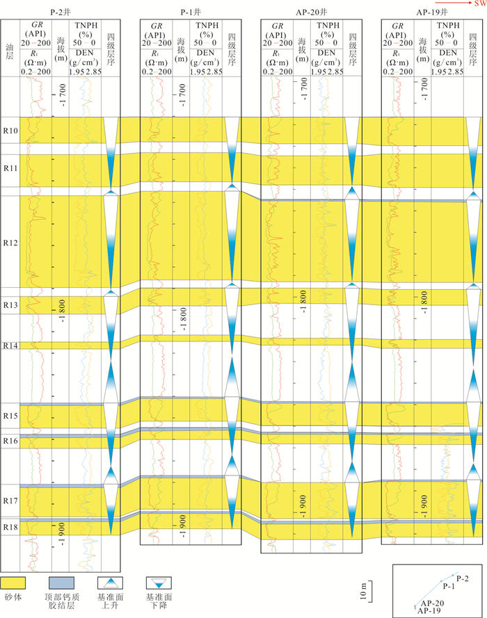
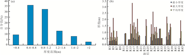
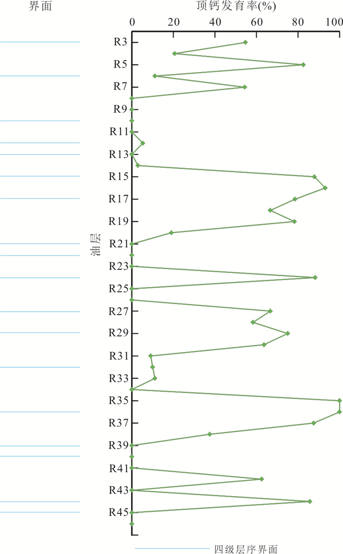
Top calcareous cementation layers (TCCLs) are common type of carbonate cement that caps reservoir sandstone units. There is no consensus on the genetic mechanism of TCCLs at present and thus hindering our understanding of its distribution prediction and restricting the oilfield exploration and development. In this paper a suite of analytical techniques were employed to investigate the genesis and distribution of TCCLs within the Zhujiang Formation in the Panyu A oilfield, Pearl River Mouth basin, including core and log analysis, XRF scanning, casting thin section, scanning electron microscopy, cathodoluminescence, electron microprobe, stable carbon and oxygen isotopes. This enabled us to systematically study the log responses, petrologic characteristics, material source and genesis, distribution patterns, and genetic distribution model of TCCLs. TCCLs in the study area comprise mainly gravel-bearing sandstone and medium-coarse sandstone, and the carbonate cements consist mostly of ferrocalcite in basement-pore contacts accompanied by biological debris, and its precipitation temperature is between 55.9 and 72 ℃. The thickness of TCCLs is mainly in the range of 0.4-1.2 m, but there exist big differences between the thickness and development percentage of TCCLs among different oil-bearing reservoir beds. The analysis indicates that TCCLs were formed in the early diagenetic stage and their material sources are mainly composed of endogenous biological debris. The distribution of TCCLs is mainly controlled by sedimentary microfacies and high-frequency sequence stratigraphy surfaces. The estuary bars provide an important material source, and the superposition of each other contributes to the contiguous thickening of TCCLs, while the high-frequency marine-flooding surface can further promote the development of TCCLs by extending the retention time of sediments. The genesis and distribution of TCCLs in the study area are primarily controlled by the enrichment degree and distribution of bio-debris. Therefore, the spatial distribution of TCCLs can be predicted through the analysis of high-frequency sequence stratigraphy and detailed microfacies characterization.
Top calcareous cementation layers (TCCLs) are common type of carbonate cement that caps reservoir sandstone units. There is no consensus on the genetic mechanism of TCCLs at present and thus hindering our understanding of its distribution prediction and restricting the oilfield exploration and development. In this paper a suite of analytical techniques were employed to investigate the genesis and distribution of TCCLs within the Zhujiang Formation in the Panyu A oilfield, Pearl River Mouth basin, including core and log analysis, XRF scanning, casting thin section, scanning electron microscopy, cathodoluminescence, electron microprobe, stable carbon and oxygen isotopes. This enabled us to systematically study the log responses, petrologic characteristics, material source and genesis, distribution patterns, and genetic distribution model of TCCLs. TCCLs in the study area comprise mainly gravel-bearing sandstone and medium-coarse sandstone, and the carbonate cements consist mostly of ferrocalcite in basement-pore contacts accompanied by biological debris, and its precipitation temperature is between 55.9 and 72 ℃. The thickness of TCCLs is mainly in the range of 0.4-1.2 m, but there exist big differences between the thickness and development percentage of TCCLs among different oil-bearing reservoir beds. The analysis indicates that TCCLs were formed in the early diagenetic stage and their material sources are mainly composed of endogenous biological debris. The distribution of TCCLs is mainly controlled by sedimentary microfacies and high-frequency sequence stratigraphy surfaces. The estuary bars provide an important material source, and the superposition of each other contributes to the contiguous thickening of TCCLs, while the high-frequency marine-flooding surface can further promote the development of TCCLs by extending the retention time of sediments. The genesis and distribution of TCCLs in the study area are primarily controlled by the enrichment degree and distribution of bio-debris. Therefore, the spatial distribution of TCCLs can be predicted through the analysis of high-frequency sequence stratigraphy and detailed microfacies characterization.


2021, 46(5): 1797-1813.
doi: 10.3799/dqkx.2020.106
Abstract:
There was a significant structural change in the Middle Eocene Wenchang rift stage in ZhuⅠdepression, which has an important impact on the basic conditions of source rocks, reservoir formation, hydrocarbon migration and accumulation. On the basis of an integrated analysis of three-dimensional seismic, drilling, logging and mud logging data, hydrocarbon generation centers and sedimentation systems in the early and late Wenchang Formation have obviously migrated, causing high abundance dark mudstones and large massive sandstones to develop vertically and horizontally in staggered stacks, under the restriction of tectonic transformation. The superposition and coupling of the dark mudstones and massive sandstones have controlled the preponderance convergence of the lower structural layer and the redistribution of oil and gas in the upper structural layer. Abundant traps in secondary structural zones provided good storage places for oil and gas distribution. Tectonic transformation has led to changes of the conditions in hydrocarbon generation, storage, transportation and accumulation. And three types of accumulation control modes have been formed in ZhuⅠdepression, namely, source rock migration, provenance migration and fault conversion.
There was a significant structural change in the Middle Eocene Wenchang rift stage in ZhuⅠdepression, which has an important impact on the basic conditions of source rocks, reservoir formation, hydrocarbon migration and accumulation. On the basis of an integrated analysis of three-dimensional seismic, drilling, logging and mud logging data, hydrocarbon generation centers and sedimentation systems in the early and late Wenchang Formation have obviously migrated, causing high abundance dark mudstones and large massive sandstones to develop vertically and horizontally in staggered stacks, under the restriction of tectonic transformation. The superposition and coupling of the dark mudstones and massive sandstones have controlled the preponderance convergence of the lower structural layer and the redistribution of oil and gas in the upper structural layer. Abundant traps in secondary structural zones provided good storage places for oil and gas distribution. Tectonic transformation has led to changes of the conditions in hydrocarbon generation, storage, transportation and accumulation. And three types of accumulation control modes have been formed in ZhuⅠdepression, namely, source rock migration, provenance migration and fault conversion.


2021, 46(5): 1814-1828.
doi: 10.3799/dqkx.2020.310
Abstract:
Nanpanjiang depression, proved to be one of the strategic exploration zones of marine shale gas in periphery of Sichuan basin, possesses a huge shale gas potential. However, the shale gas exploration in Nanpanjiang depression has been restricted seriously, mainly for the late start of shale gas exploration and non-clear target selection. Based on the field investigation and previous studies in northeastern Nanpanjiang depression, the Lower Carboniferous Luzhai shale distribution was ascertained. According to the organic geochemistry, X-ray diffraction, and scanning electron microscopy (SEM), the source rock geochemical characteristics, shale reservoir characteristics, and shale gas preservation conditions were analyzed. The study shows that the thickness of Luzhai shale in northeastern Nanpanjiang depression is mainly 250-350 m, and the burial depth of the shale is mainly 1 000-3 000 m. The TOC values of the Luzhai shale are mainly >2.0%, and the kerogen types are mainly Type Ⅱ1-Ⅱ2. The organic matters in shale mainly reach the high-to over-mature stage, suggesting that the shale should possess an excellent source rock potential. The contents of brittle minerals in the Luzhai shale are relatively high, and the pore spaces in the shale and the adsorption capacities of shale are well developed, indicating a well-developed shale gas reservoir. The high content of clay minerals and relatively strong compaction and cementation in the shale strengthened the relatively strong self-seal capacity of shale, indicating good preservation conditions for shale gas. Multi-episodes tectonic movements played an important role on the shale gas preservation. Compared with accumulation conditions of the typical shale gas in domestic and foreign basins, the Luzhai shales in the northeastern Nanpanjiang depression possess favorable accumulation conditions for shale gas, suggesting the northeastern part of Donglan area in the Nanpanjiang depression should be a favorable shale gas exploration zone in South China.
Nanpanjiang depression, proved to be one of the strategic exploration zones of marine shale gas in periphery of Sichuan basin, possesses a huge shale gas potential. However, the shale gas exploration in Nanpanjiang depression has been restricted seriously, mainly for the late start of shale gas exploration and non-clear target selection. Based on the field investigation and previous studies in northeastern Nanpanjiang depression, the Lower Carboniferous Luzhai shale distribution was ascertained. According to the organic geochemistry, X-ray diffraction, and scanning electron microscopy (SEM), the source rock geochemical characteristics, shale reservoir characteristics, and shale gas preservation conditions were analyzed. The study shows that the thickness of Luzhai shale in northeastern Nanpanjiang depression is mainly 250-350 m, and the burial depth of the shale is mainly 1 000-3 000 m. The TOC values of the Luzhai shale are mainly >2.0%, and the kerogen types are mainly Type Ⅱ1-Ⅱ2. The organic matters in shale mainly reach the high-to over-mature stage, suggesting that the shale should possess an excellent source rock potential. The contents of brittle minerals in the Luzhai shale are relatively high, and the pore spaces in the shale and the adsorption capacities of shale are well developed, indicating a well-developed shale gas reservoir. The high content of clay minerals and relatively strong compaction and cementation in the shale strengthened the relatively strong self-seal capacity of shale, indicating good preservation conditions for shale gas. Multi-episodes tectonic movements played an important role on the shale gas preservation. Compared with accumulation conditions of the typical shale gas in domestic and foreign basins, the Luzhai shales in the northeastern Nanpanjiang depression possess favorable accumulation conditions for shale gas, suggesting the northeastern part of Donglan area in the Nanpanjiang depression should be a favorable shale gas exploration zone in South China.


2021, 46(5): 1829-1839.
doi: 10.3799/dqkx.2020.148
Abstract:
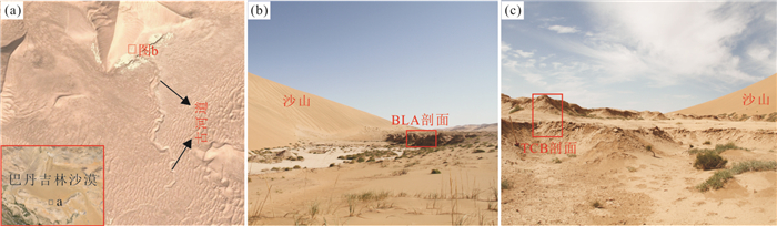
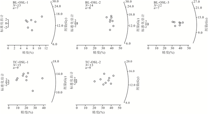
Alluvial-diluvial deposits can record climatic and hydrologic information in geological history and play an important role in the reconstruction of paleoenvironment. Aqueous deposits were discovered at the south margin of Badain Jaran desert, Northwest China. Based on sedimentological analyses, two sections of the deposits as palaeoflood deposit and paleofluvial deposit were identified. OSL dating suggests that the deposits formed in the Middle Holocene. The alluvial-diluvial deposits in the southern margin of Badain Jaran Desert were mainly formed under a humid climate during the Middle Holocene. Based on the previous paleoclimate study, comprehensive analysis of the location and sedimentary features and the previous research of paleoclimate in this region, a conceptual model of recharge to the Badain Jaran is proposed. During humid climatic phases, such as the Middle Holocene, the precipitation in this region and adjacent mountain areas recharged the groundwater of the desert area by temporary flood or/and intermittent stream.
Alluvial-diluvial deposits can record climatic and hydrologic information in geological history and play an important role in the reconstruction of paleoenvironment. Aqueous deposits were discovered at the south margin of Badain Jaran desert, Northwest China. Based on sedimentological analyses, two sections of the deposits as palaeoflood deposit and paleofluvial deposit were identified. OSL dating suggests that the deposits formed in the Middle Holocene. The alluvial-diluvial deposits in the southern margin of Badain Jaran Desert were mainly formed under a humid climate during the Middle Holocene. Based on the previous paleoclimate study, comprehensive analysis of the location and sedimentary features and the previous research of paleoclimate in this region, a conceptual model of recharge to the Badain Jaran is proposed. During humid climatic phases, such as the Middle Holocene, the precipitation in this region and adjacent mountain areas recharged the groundwater of the desert area by temporary flood or/and intermittent stream.


2021, 46(5): 1840-1847.
doi: 10.3799/dqkx.2020.271
Abstract:
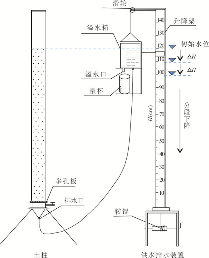
Specific yield is one of the most important hydrogeological parameters of unconfined aquifer. In order to study the influencing factors of specific yield, the laboratory column drainage experiment was developed to estimate specific yield of homogeneous and stratified heterogeneous sand columns. The groundwater level was decreased according to segmentation of 2 cm or 5 cm and each section kept different drainage times to obtain the specific yield value of different depth to water table. When the depth to water table was within the capillary rise height, the relationship between specific yield and water table depth can be expressed by a nonlinear function. The specific yield value increased with the drainage time and it became constant when the drainage time of each drawdown section was more than one hour. Specific yield value of coarse sand with particle size 0.6-0.9 mm was always larger than that of fine sand with particle size 0.2-0.4 mm. When groundwater level was 20 cm under the layer interface, two different columnar structures of upper-coarse-lower-fine and vice versa exerted distinct impacts on the magnitude of specific yield. For shallow unconfined aquifer, specific yield varied with the initial depth to water table, duration of drainage, soil texture and heterogeneity near the water table.
Specific yield is one of the most important hydrogeological parameters of unconfined aquifer. In order to study the influencing factors of specific yield, the laboratory column drainage experiment was developed to estimate specific yield of homogeneous and stratified heterogeneous sand columns. The groundwater level was decreased according to segmentation of 2 cm or 5 cm and each section kept different drainage times to obtain the specific yield value of different depth to water table. When the depth to water table was within the capillary rise height, the relationship between specific yield and water table depth can be expressed by a nonlinear function. The specific yield value increased with the drainage time and it became constant when the drainage time of each drawdown section was more than one hour. Specific yield value of coarse sand with particle size 0.6-0.9 mm was always larger than that of fine sand with particle size 0.2-0.4 mm. When groundwater level was 20 cm under the layer interface, two different columnar structures of upper-coarse-lower-fine and vice versa exerted distinct impacts on the magnitude of specific yield. For shallow unconfined aquifer, specific yield varied with the initial depth to water table, duration of drainage, soil texture and heterogeneity near the water table.


2021, 46(5): 1848-1861.
doi: 10.3799/dqkx.2020.142
Abstract:
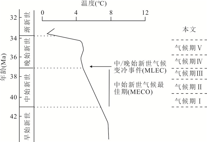
For rebuilding the paleoclimate during Mid-Late Eocene in Northeast China, it analyzes the palynological characteristics in Fusun basin. Combining coniss analysis with co-existence approach, it quantitatively reconstructs the paleoclimate parameters in research area. 67 genera are identified and divided into 5 assemblages as: (Ⅰ) Quercoidites-Tricolpopollenites-Betulaceoipollenites Assemblage; (Ⅱ) Piceapollis-Tiliaepollenites-Chenopodipollis Assemblage; (Ⅲ) Quercoidites-Betulaceoipollenites-Ulmipollenites Assemblage; (Ⅳ)Pinuspollenites-Abietineaepollenites-Ephedripites Assemblage; (Ⅴ) Betulaceoipollenites-Taxodiaceaepollenites-Quercoidites Assemblage. The age of assemblages Ⅰ, Ⅱ, Ⅲ belongs to Middle Eocene, and the age of assemblages Ⅳ, Ⅴ belongs to Late Eocene. The vegetation types of the basin experienced the transformation as deciduous broadleaf forest-steppe type vegetation→coniferous and broadleaf mixed forest-steppe type vegetation→deciduous broadleaf forest-steppe type vegetation→ coniferous forest→coniferous broadleaf mixed forest. The climatic zone changed from subtropical-temperate to temperate, the humidity changed from humid to semi-humid, and the average annual moderate and annual average rainfall decreased. This trend is coupled with the global temperature trend.
For rebuilding the paleoclimate during Mid-Late Eocene in Northeast China, it analyzes the palynological characteristics in Fusun basin. Combining coniss analysis with co-existence approach, it quantitatively reconstructs the paleoclimate parameters in research area. 67 genera are identified and divided into 5 assemblages as: (Ⅰ) Quercoidites-Tricolpopollenites-Betulaceoipollenites Assemblage; (Ⅱ) Piceapollis-Tiliaepollenites-Chenopodipollis Assemblage; (Ⅲ) Quercoidites-Betulaceoipollenites-Ulmipollenites Assemblage; (Ⅳ)Pinuspollenites-Abietineaepollenites-Ephedripites Assemblage; (Ⅴ) Betulaceoipollenites-Taxodiaceaepollenites-Quercoidites Assemblage. The age of assemblages Ⅰ, Ⅱ, Ⅲ belongs to Middle Eocene, and the age of assemblages Ⅳ, Ⅴ belongs to Late Eocene. The vegetation types of the basin experienced the transformation as deciduous broadleaf forest-steppe type vegetation→coniferous and broadleaf mixed forest-steppe type vegetation→deciduous broadleaf forest-steppe type vegetation→ coniferous forest→coniferous broadleaf mixed forest. The climatic zone changed from subtropical-temperate to temperate, the humidity changed from humid to semi-humid, and the average annual moderate and annual average rainfall decreased. This trend is coupled with the global temperature trend.


2021, 46(5): 1862-1870.
doi: 10.3799/dqkx.2020.149
Abstract:
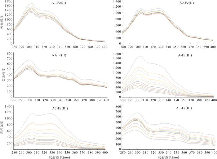
In order to study the complexing stability of organic iron complexes from peat, the stability of DOM-Fe2+, Fe3+ in different molecular weights of Dajiuhu peatland was determined by potentiometric titration and fluorescence quenching titration. There are obvious differences between the results of potentiometric titration (4.0-6.1) and fluorescence quenching titration (1.5-4.1), which can be explained by the deprotonation of OH in high pH value and the oxidation of Fe2+ during the experiments. Potentiometric titration is suitable for studying the complexing stability of different molecular weights of DOM-Fe; the pH would not change during the experiment using fluorescence quenching titration method. Thus, the fluorescence method can be well applied to the element of variable valency. The results show that the complexing stability constants of DOM-Fe3+ is higher than that of Fe2+, and that of low-molecular-weight DOM with Fe2+ and Fe3+ is higher. The experiment indicates that high stability of DOM-Fe in peat, and relatively low-molecular-weight DOM has stronger ability to complex iron. Even Fe2+ is oxidized to Fe3+, it can still complex with DOM stably, which is conducive to the output of terrestrial dissolved iron to aquatic ecosystem. The complexing stability of iron organic complexes from peat will also affect the bioavailability of iron.
In order to study the complexing stability of organic iron complexes from peat, the stability of DOM-Fe2+, Fe3+ in different molecular weights of Dajiuhu peatland was determined by potentiometric titration and fluorescence quenching titration. There are obvious differences between the results of potentiometric titration (4.0-6.1) and fluorescence quenching titration (1.5-4.1), which can be explained by the deprotonation of OH in high pH value and the oxidation of Fe2+ during the experiments. Potentiometric titration is suitable for studying the complexing stability of different molecular weights of DOM-Fe; the pH would not change during the experiment using fluorescence quenching titration method. Thus, the fluorescence method can be well applied to the element of variable valency. The results show that the complexing stability constants of DOM-Fe3+ is higher than that of Fe2+, and that of low-molecular-weight DOM with Fe2+ and Fe3+ is higher. The experiment indicates that high stability of DOM-Fe in peat, and relatively low-molecular-weight DOM has stronger ability to complex iron. Even Fe2+ is oxidized to Fe3+, it can still complex with DOM stably, which is conducive to the output of terrestrial dissolved iron to aquatic ecosystem. The complexing stability of iron organic complexes from peat will also affect the bioavailability of iron.


2021, 46(5): 1871-1880.
doi: 10.3799/dqkx.2020.383
Abstract:
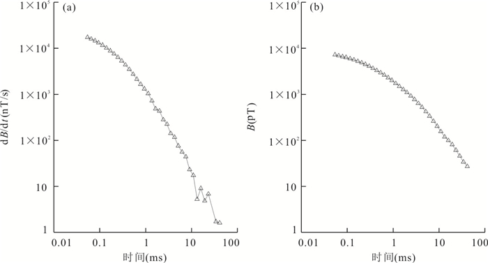
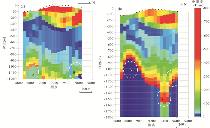
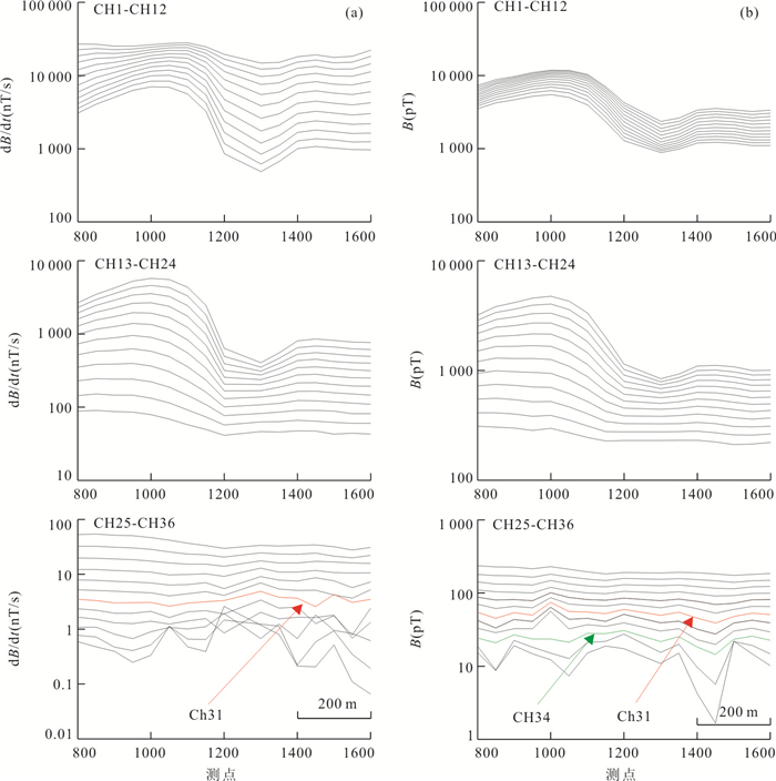
In order to improve the detection depth of TEM, the TEM experiment based on HTS sensor was carried out in Qingchengzi ore-concentrated area. The results show that the HTS sensor has the advantages of low noise, high sensitivity and good response at low frequency. Under the same excitation condition and low noise background, the detection depth of TEM based on HTS sensor in Qingchengzi ore-concentrated area can reach about 1 800 m, which is 50% higher than that of conventional coil sensor, indicating this method can effectively improve the detection depth of TEM.
In order to improve the detection depth of TEM, the TEM experiment based on HTS sensor was carried out in Qingchengzi ore-concentrated area. The results show that the HTS sensor has the advantages of low noise, high sensitivity and good response at low frequency. Under the same excitation condition and low noise background, the detection depth of TEM based on HTS sensor in Qingchengzi ore-concentrated area can reach about 1 800 m, which is 50% higher than that of conventional coil sensor, indicating this method can effectively improve the detection depth of TEM.


2021, 46(5): 1881-1895.
doi: 10.3799/dqkx.2020.134
Abstract:
With the accumulation of measured magnetic data, it is becoming urgent to use these data efficiently. Previous studies have shown that it is difficult to meet the accuracy requirement for solving geological problems by using the measured data from a single observation method. Because of the limitations and differences in resolution, accuracy, elevation and range of magnetic data obtained by various methods, single dataset can only effectively reflect the information over a certain range of wavelength of magnetic field. An effective way to solve this problem is the fusion of data. Therefore, based on the equivalent source method, a multi-layer equivalent source technology is proposed in this paper, which can be applied to the fusion of ground and airborne magnetic data to improve the accuracy of interpolation, continuation, extension, transformation, et al. According to the spectral characteristics of observation data, three-layer equivalent sources at different depths are used to fit the measured data. Compared with the traditional single-layer equivalent source method, it can reduce the blindness for setting equivalent sources, and improve the ordering and structural performance for allotting observation information into equivalent sources. Synthetic experiment shows that the three-layer model has higher computational accuracy, and data fusion can significantly improve each dataset. Finally, the method is applied to the fusion of ground and airborne magnetic data in Jinniu basin, Hubei, and abundant magnetic data with regular distribution on a plane are obtained.
With the accumulation of measured magnetic data, it is becoming urgent to use these data efficiently. Previous studies have shown that it is difficult to meet the accuracy requirement for solving geological problems by using the measured data from a single observation method. Because of the limitations and differences in resolution, accuracy, elevation and range of magnetic data obtained by various methods, single dataset can only effectively reflect the information over a certain range of wavelength of magnetic field. An effective way to solve this problem is the fusion of data. Therefore, based on the equivalent source method, a multi-layer equivalent source technology is proposed in this paper, which can be applied to the fusion of ground and airborne magnetic data to improve the accuracy of interpolation, continuation, extension, transformation, et al. According to the spectral characteristics of observation data, three-layer equivalent sources at different depths are used to fit the measured data. Compared with the traditional single-layer equivalent source method, it can reduce the blindness for setting equivalent sources, and improve the ordering and structural performance for allotting observation information into equivalent sources. Synthetic experiment shows that the three-layer model has higher computational accuracy, and data fusion can significantly improve each dataset. Finally, the method is applied to the fusion of ground and airborne magnetic data in Jinniu basin, Hubei, and abundant magnetic data with regular distribution on a plane are obtained.
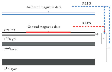


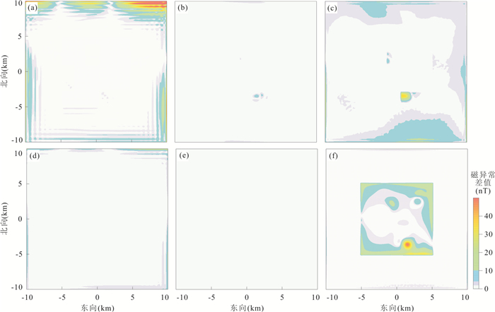
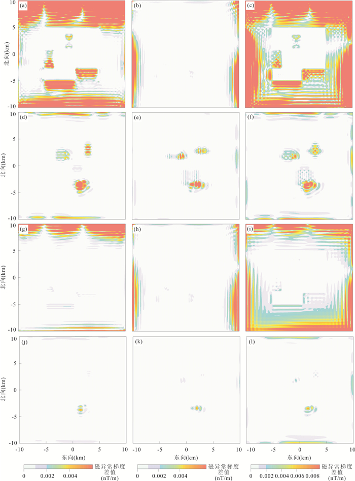


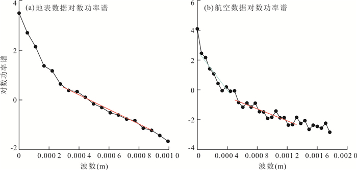


2021, 46(5): 1896-1908.
doi: 10.3799/dqkx.2020.155
Abstract:
The development and utilization of urban underground space is an inevitable way of urban sustainable development. Scientific and reasonable evaluation of urban underground space suitability can provide decision-making basis for urban three-dimensional planning. Therefore, it is very important to evaluate the suitability of underground space in different areas of cities. The research status quo of urban underground space suitability evaluation is systematically reviewed from the aspects of urban underground space suitability evaluation visualization, evaluation index, weight system, evaluation model, evaluation mode and evaluation system. Then, the main content and future development direction of urban underground space suitability evaluation are discussed, which focuses on the key issues such as the quantification of urban underground space suitability evaluation index, the reliability of visualized results of urban underground space suitability evaluation and the universality of three-dimensional evaluation system of urban underground space suitability. In this paper, it may deepen the evaluation of the suitability of urban underground space and provide some guidances for the development and utilization of urban underground space.
The development and utilization of urban underground space is an inevitable way of urban sustainable development. Scientific and reasonable evaluation of urban underground space suitability can provide decision-making basis for urban three-dimensional planning. Therefore, it is very important to evaluate the suitability of underground space in different areas of cities. The research status quo of urban underground space suitability evaluation is systematically reviewed from the aspects of urban underground space suitability evaluation visualization, evaluation index, weight system, evaluation model, evaluation mode and evaluation system. Then, the main content and future development direction of urban underground space suitability evaluation are discussed, which focuses on the key issues such as the quantification of urban underground space suitability evaluation index, the reliability of visualized results of urban underground space suitability evaluation and the universality of three-dimensional evaluation system of urban underground space suitability. In this paper, it may deepen the evaluation of the suitability of urban underground space and provide some guidances for the development and utilization of urban underground space.