2021 Vol. 46, No. 7
Display Method:
 PDF 477KB
2021, 46(7): 2287-2298.
doi: 10.3799/dqkx.2020.212
Abstract:
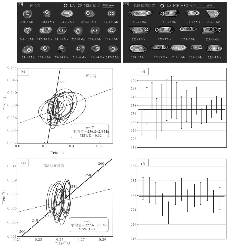
The Early Mesozoic magmatism of the eastern Tianshan was just reported recently, the source and tectonic setting of which are poorly understood. Formed during the Early Mesozoic, the Bailingshanxi gabbro and porphyritic granite were recently discovered. In this study, new geochemistry, zircon U-Pb dating and whole-rock Sr-Nd isotope data are provided for these intrusions. Zircon LA-ICP-MS U-Pb dating results reveal that the gabbro and porphyritic granite emplaced at ca. 236 Ma and 228 Ma, respectively. The Bailingshanxi gabbro has low SiO2 (43.50%-46.03%) content, and high CaO (11.40%-13.24%), Fe2O3T(9.62%-11.84%) and MgO (6.02%-10.58%; Mg#=53-69) contents. Meanwhile, it is characterized by high Ce/Pb, Ti/Zr, Ti/Y and Ba/Th ratios, and rich in LREE and LILE (e.g., Ba and Sr), indicating the Bailingshanxi gabbro was originated from the partial melting of the metasomated mantle wedge. Showing high SiO2 (71.14%-72.71%), LREE ((La/Yb)N=12.61-28.45) and LILE (e.g., Rb, K and Pb), the Bailingshanxi porphyritic granite was likely derived from the partial melting of the lower crust. Additionally, it has high Mg# (39—-41) value and Ti/Y (154.40-306.18) ratios, implying mantle component played an important role in the formation of the porphyritic granite. Integrating with previous studies, the Eastern Tianshan is probably under inter-plat environment after 240 Ma, and the Bailignshanxi gabbro and porphyritic granite were formed during this stage.
The Early Mesozoic magmatism of the eastern Tianshan was just reported recently, the source and tectonic setting of which are poorly understood. Formed during the Early Mesozoic, the Bailingshanxi gabbro and porphyritic granite were recently discovered. In this study, new geochemistry, zircon U-Pb dating and whole-rock Sr-Nd isotope data are provided for these intrusions. Zircon LA-ICP-MS U-Pb dating results reveal that the gabbro and porphyritic granite emplaced at ca. 236 Ma and 228 Ma, respectively. The Bailingshanxi gabbro has low SiO2 (43.50%-46.03%) content, and high CaO (11.40%-13.24%), Fe2O3T(9.62%-11.84%) and MgO (6.02%-10.58%; Mg#=53-69) contents. Meanwhile, it is characterized by high Ce/Pb, Ti/Zr, Ti/Y and Ba/Th ratios, and rich in LREE and LILE (e.g., Ba and Sr), indicating the Bailingshanxi gabbro was originated from the partial melting of the metasomated mantle wedge. Showing high SiO2 (71.14%-72.71%), LREE ((La/Yb)N=12.61-28.45) and LILE (e.g., Rb, K and Pb), the Bailingshanxi porphyritic granite was likely derived from the partial melting of the lower crust. Additionally, it has high Mg# (39—-41) value and Ti/Y (154.40-306.18) ratios, implying mantle component played an important role in the formation of the porphyritic granite. Integrating with previous studies, the Eastern Tianshan is probably under inter-plat environment after 240 Ma, and the Bailignshanxi gabbro and porphyritic granite were formed during this stage.


2021, 46(7): 2299-2310.
doi: 10.3799/dqkx.2020.209
Abstract:
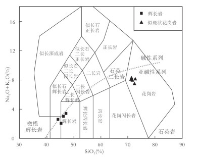
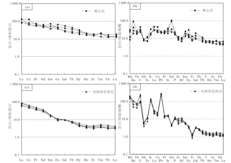
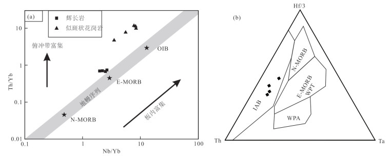
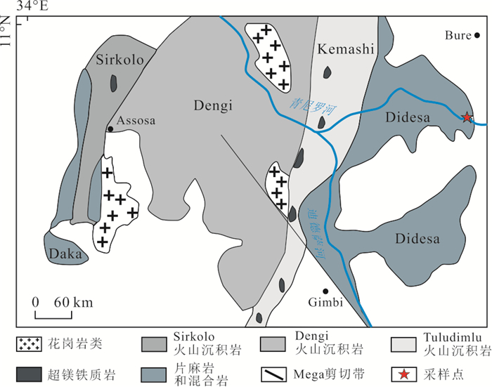
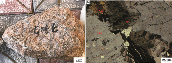
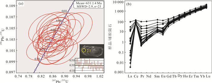
In order to furtherly constrain the evolution of regional geological structure in the western Ethiopia, we selected the magmatic rocks from the Bure area of western Ethiopia for petrogeochemical and chronologic analysis.The Burequartz monzonite in western Ethiopia has relatively high SiO2(66.4% to 68.5%), K2O (4.56% to 4.87%), and iron value (TFeO/(TFeO+MgO) is 0.75 to 0.79), and relatively low MgO (0.8% to 1.3%), CaO (2.01% to 2.36%), and A/CNK (0.89~0.96), withthe characteristic that areemriched in elements such as Zr, Hf, Y, and Ga, and depleted Sr, P, Ti, and Eu elements, which reveal the feature of A-type granite. The zircon LA-ICP-MS U-Pb age of the rock is 631±4 Ma (MSWD=2.9), representing the extension stage of the East African orogenic movement. The εHf(t) values of Bure A-type granite range from 3.2 to 9.1 (average=7.3), showing a relatively inhomegeneous feature. The Bure A-type granite formed in the post-stretching environment of the East African orogenic movement. Thewhole rock geochemistryand Hf isotopic characteristicssuggest that the Bure A-type granite may originated from basaltic magma in the thinned lithospheric mantle, and then formed through extensive crystallization differentiation.
In order to furtherly constrain the evolution of regional geological structure in the western Ethiopia, we selected the magmatic rocks from the Bure area of western Ethiopia for petrogeochemical and chronologic analysis.The Burequartz monzonite in western Ethiopia has relatively high SiO2(66.4% to 68.5%), K2O (4.56% to 4.87%), and iron value (TFeO/(TFeO+MgO) is 0.75 to 0.79), and relatively low MgO (0.8% to 1.3%), CaO (2.01% to 2.36%), and A/CNK (0.89~0.96), withthe characteristic that areemriched in elements such as Zr, Hf, Y, and Ga, and depleted Sr, P, Ti, and Eu elements, which reveal the feature of A-type granite. The zircon LA-ICP-MS U-Pb age of the rock is 631±4 Ma (MSWD=2.9), representing the extension stage of the East African orogenic movement. The εHf(t) values of Bure A-type granite range from 3.2 to 9.1 (average=7.3), showing a relatively inhomegeneous feature. The Bure A-type granite formed in the post-stretching environment of the East African orogenic movement. Thewhole rock geochemistryand Hf isotopic characteristicssuggest that the Bure A-type granite may originated from basaltic magma in the thinned lithospheric mantle, and then formed through extensive crystallization differentiation.


2021, 46(7): 2311-2328.
doi: 10.3799/dqkx.2020.214
Abstract:
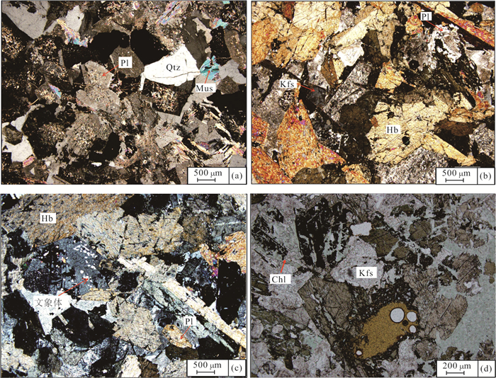
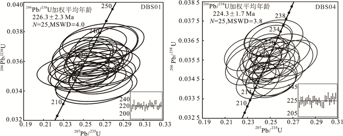
Hornblende gabbro and tonalite which emplaced in Late Ordovician granodiorite were found in Duobaoshan mining area, possessed the characteristics of bimodal pattern intrusive rock.On the basis of detailed field geological survey, we reaserched the petrology, geochronology and geochemistry characteristics of bimodal pattern intrusive rock, and discuss their tectonic significance. The LA-ICP-MS zircon U-Pb ages of hornblende gabbro is 224.3±1.7 Ma, the LA-ICP-MS zircon U-Pb ages of tonalite is 226.3±2.3 Ma, they were both formed by the same tectonic magmatism.The SiO2 content of intrusive rock is bimodal, their rare earth elements and microelements indicates the characteristics of island arc magma.They have the same mantle source, which influenced by the subduction metasomatic alteration of fluids. Based on analysis of the regional tectonic background, its formation is related to the Okhotsk subduction. The gabbro and tonalite which formed in the active continental margin environment, were interpreted to be formed through assimilation of OIB-type basaltic magma followed by fractional crystallization in a.double diffusive'magma chamber at the middle crust level.
Hornblende gabbro and tonalite which emplaced in Late Ordovician granodiorite were found in Duobaoshan mining area, possessed the characteristics of bimodal pattern intrusive rock.On the basis of detailed field geological survey, we reaserched the petrology, geochronology and geochemistry characteristics of bimodal pattern intrusive rock, and discuss their tectonic significance. The LA-ICP-MS zircon U-Pb ages of hornblende gabbro is 224.3±1.7 Ma, the LA-ICP-MS zircon U-Pb ages of tonalite is 226.3±2.3 Ma, they were both formed by the same tectonic magmatism.The SiO2 content of intrusive rock is bimodal, their rare earth elements and microelements indicates the characteristics of island arc magma.They have the same mantle source, which influenced by the subduction metasomatic alteration of fluids. Based on analysis of the regional tectonic background, its formation is related to the Okhotsk subduction. The gabbro and tonalite which formed in the active continental margin environment, were interpreted to be formed through assimilation of OIB-type basaltic magma followed by fractional crystallization in a.double diffusive'magma chamber at the middle crust level.


2021, 46(7): 2329-2340.
doi: 10.3799/dqkx.2020.258
Abstract:
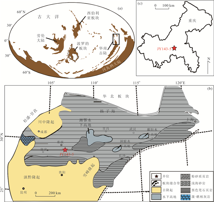
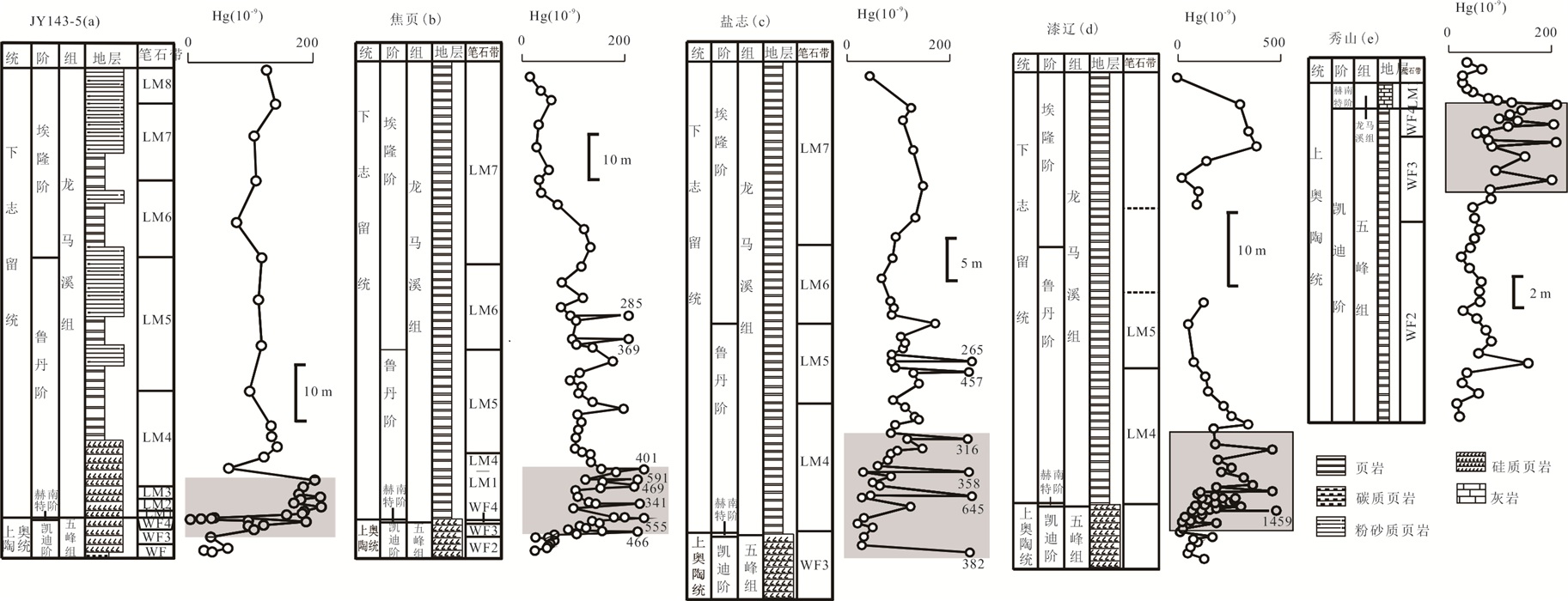
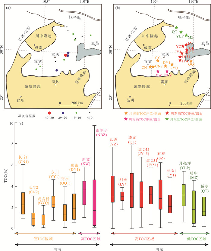
In order to investigate the influence of volcanism on the enrichment mechanism of organic matter in black mudstone, we analysis mercury, total sulfur, total organic carbon and barium concentrations from core JY 143-5 in Wulong District, Chongqing, exploring the relationship between volcanisms and enrichments of organic matter near the Ordovician-Silurian transition (Wufeng Formation-Longmaxi Formation) in the middle and upper Yangtze region. The results show that the enrichment intervals of mercury (the bottom of Longmaxi Formation) corresponds to the high values of marine productivity (total organic carbon and biological barium). Furthermore, the thickness of volcanic ash in the upper Yangtze area has a strong relationship with the spatial distribution of total organic carbon content, which also support the hypotheses that volcanism is closely related to the enrichment of organic matter. Therefore, this study suggests that multiple and extensive volcanic eruptions were likely tobe the main cause of the enrichment of organic matter between Ordovician and Silurian in middle-upper Yangtze region.
In order to investigate the influence of volcanism on the enrichment mechanism of organic matter in black mudstone, we analysis mercury, total sulfur, total organic carbon and barium concentrations from core JY 143-5 in Wulong District, Chongqing, exploring the relationship between volcanisms and enrichments of organic matter near the Ordovician-Silurian transition (Wufeng Formation-Longmaxi Formation) in the middle and upper Yangtze region. The results show that the enrichment intervals of mercury (the bottom of Longmaxi Formation) corresponds to the high values of marine productivity (total organic carbon and biological barium). Furthermore, the thickness of volcanic ash in the upper Yangtze area has a strong relationship with the spatial distribution of total organic carbon content, which also support the hypotheses that volcanism is closely related to the enrichment of organic matter. Therefore, this study suggests that multiple and extensive volcanic eruptions were likely tobe the main cause of the enrichment of organic matter between Ordovician and Silurian in middle-upper Yangtze region.


2021, 46(7): 2341-2350.
doi: 10.3799/dqkx.2020.194
Abstract:
The even number law (that is,"Oddo-Harkins" law) holds that a given element with even atomic number is more abundant than both the adjacent elements with odd atomic numbers,which is widely-used in geochemistry,astrochemistry and even cosmochemistry. The present study shows that the distribution/allocation of chemical elements (at least for non-atmophile elements) in various natural systems also exhibits cyclical changes in statistics,which is well consistent with the "Periodic Law". In fact,there exists certain intrinsic relationship between the even number law and the cyclical changes stated in present study,and they just signature a same geochemical phenomenon from different angles. For two random natural systems (the Earth and Venus,for instance),the more similar the processes,mechanisms,stages and conditions of their formation and evolution,their material sources and chemical compositions are,the more consistent their variation waveforms of elemental abundance ratios are with the "Periodic Law". The matching degree between the distribution/allocation curve of elements in various natural systems and the periodic variation curve of these elements has been further determined. Overall,the discovery of cyclical changes of elemental distribution and its quantitative characterization provide a new perspective for calculating,checking and acquiring basic data on chemical elements in a natural system.
The even number law (that is,"Oddo-Harkins" law) holds that a given element with even atomic number is more abundant than both the adjacent elements with odd atomic numbers,which is widely-used in geochemistry,astrochemistry and even cosmochemistry. The present study shows that the distribution/allocation of chemical elements (at least for non-atmophile elements) in various natural systems also exhibits cyclical changes in statistics,which is well consistent with the "Periodic Law". In fact,there exists certain intrinsic relationship between the even number law and the cyclical changes stated in present study,and they just signature a same geochemical phenomenon from different angles. For two random natural systems (the Earth and Venus,for instance),the more similar the processes,mechanisms,stages and conditions of their formation and evolution,their material sources and chemical compositions are,the more consistent their variation waveforms of elemental abundance ratios are with the "Periodic Law". The matching degree between the distribution/allocation curve of elements in various natural systems and the periodic variation curve of these elements has been further determined. Overall,the discovery of cyclical changes of elemental distribution and its quantitative characterization provide a new perspective for calculating,checking and acquiring basic data on chemical elements in a natural system.


2021, 46(7): 2351-2361.
doi: 10.3799/dqkx.2020.282
Abstract:
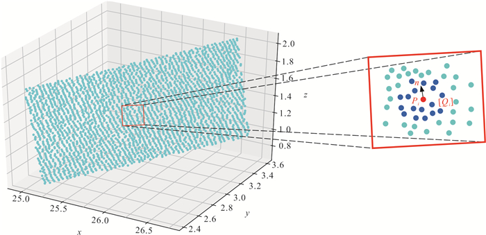
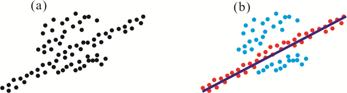
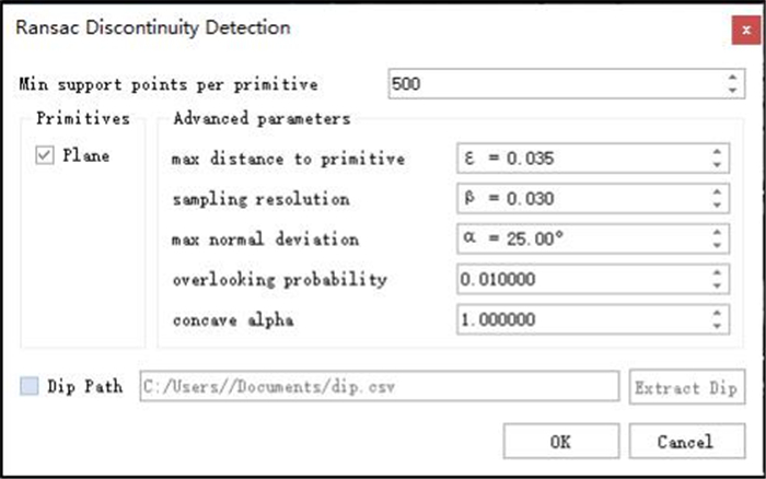
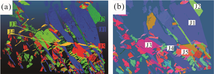
The stability of rock mass is mainly controlled by a large number of internal discontinuities. Therefore, the accurate and efficient extraction of discontinuity information is a significant process to analyze the stability of rock mass. In the paper, the raw point cloud data is collected by three-dimensional laser scanner, a new approach about automatic extraction of discontinuity is proposed based on point cloud model of rock mass, which can automatically decipher the parameters of rock mass discontinuities. The new sampling method and evaluation method are successfully introduced based on the modified Ransac algorithm, the efficiency and accuracy of Ransac algorithm are rapidly improved to adapt rough point cloud data of rock mass. The modified Graham Scan algorithm is proposed to delineate the convex-concave boundary and to calculate the size for discontinuity. Based on the above algorithms, this paper developed a discontinuity extraction program named RDD (ransac discontinuity dtection). RDD is tested by two sets of standard geometry data and one set of rock mass data. The results indicate that the orientation error of standard geometry is less than 1ånd the maximum error of rock is less than 6°, which satisfy the prescriptive error requirements of engineering.
The stability of rock mass is mainly controlled by a large number of internal discontinuities. Therefore, the accurate and efficient extraction of discontinuity information is a significant process to analyze the stability of rock mass. In the paper, the raw point cloud data is collected by three-dimensional laser scanner, a new approach about automatic extraction of discontinuity is proposed based on point cloud model of rock mass, which can automatically decipher the parameters of rock mass discontinuities. The new sampling method and evaluation method are successfully introduced based on the modified Ransac algorithm, the efficiency and accuracy of Ransac algorithm are rapidly improved to adapt rough point cloud data of rock mass. The modified Graham Scan algorithm is proposed to delineate the convex-concave boundary and to calculate the size for discontinuity. Based on the above algorithms, this paper developed a discontinuity extraction program named RDD (ransac discontinuity dtection). RDD is tested by two sets of standard geometry data and one set of rock mass data. The results indicate that the orientation error of standard geometry is less than 1ånd the maximum error of rock is less than 6°, which satisfy the prescriptive error requirements of engineering.


2021, 46(7): 2362-2378.
doi: 10.3799/dqkx.2020.202
Abstract:
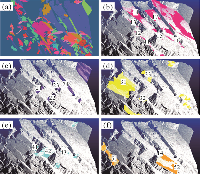
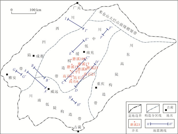
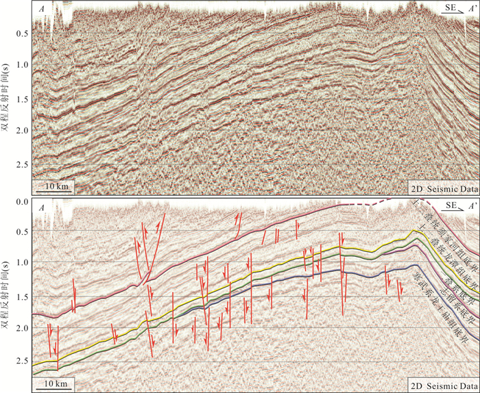
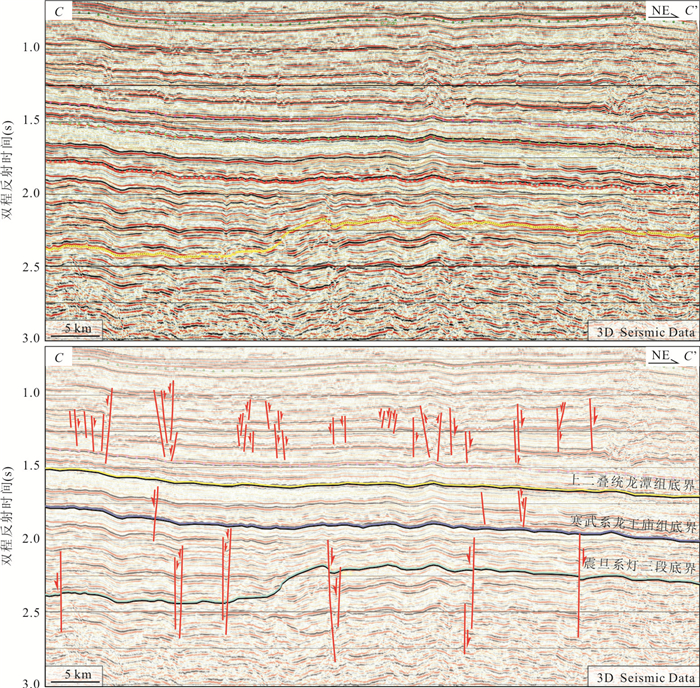
Previous studies on fault systems mainly focused on thrust belts around the basin and Gaoshiti-Moxi area in central basion. For other areas of the basin, the features, evolution and stress field of fault system is not well understood. In this study, it is newly discovered that a regional transtensional fault system is developed in Zitong-Chengdu-Weiyuan-Huayingshan-Guangan area based on seismic data interpretation. The faults have similar features in the basin, mainly extending from strata of the Sinian system to the Permian system. The faults have vertical occurrence, small normal displacement and negative flower structure. Based on three evidences, it is inferred that the faults are developed in the Himalayan Period: (1) In the Weiyuan-Ziyang area with oblique formations, the fault are still vertical. So the faults are developed after the formation of the Weiyuan anticline which is developed in the Himalayan perioid. (2) Some faults, extending to strata of the Triassic-Jurassic, are of the same system of transtensional faults in the Sinian-Permian strata. Therefore the faults are developed later than the Late Indosinian Period. (3) The distribution of transtensional faults varies from the central part to the compressional areas around the basin, and the stress field of the basin started to vary from the Late Indosinian Period. Based on physical simulation, it is inferred that the faults were developed under torsional stress field. The development of the faults indicates that a NE-SW direction tensional stress field existed in Sichuan basin in the Cenozoic Period. The stress field may originated from the clockwise rotation of the Sichuan basin in the Cenozoic Period.
Previous studies on fault systems mainly focused on thrust belts around the basin and Gaoshiti-Moxi area in central basion. For other areas of the basin, the features, evolution and stress field of fault system is not well understood. In this study, it is newly discovered that a regional transtensional fault system is developed in Zitong-Chengdu-Weiyuan-Huayingshan-Guangan area based on seismic data interpretation. The faults have similar features in the basin, mainly extending from strata of the Sinian system to the Permian system. The faults have vertical occurrence, small normal displacement and negative flower structure. Based on three evidences, it is inferred that the faults are developed in the Himalayan Period: (1) In the Weiyuan-Ziyang area with oblique formations, the fault are still vertical. So the faults are developed after the formation of the Weiyuan anticline which is developed in the Himalayan perioid. (2) Some faults, extending to strata of the Triassic-Jurassic, are of the same system of transtensional faults in the Sinian-Permian strata. Therefore the faults are developed later than the Late Indosinian Period. (3) The distribution of transtensional faults varies from the central part to the compressional areas around the basin, and the stress field of the basin started to vary from the Late Indosinian Period. Based on physical simulation, it is inferred that the faults were developed under torsional stress field. The development of the faults indicates that a NE-SW direction tensional stress field existed in Sichuan basin in the Cenozoic Period. The stress field may originated from the clockwise rotation of the Sichuan basin in the Cenozoic Period.


2021, 46(7): 2379-2390.
doi: 10.3799/dqkx.2020.252
Abstract:
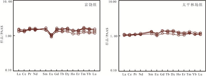
To constrain the provenance characteristics and tectonic setting of the Late Cretaceous Furao and Taipinglinchang formations located in the Sunwu-Jiayin Bbasin, in this paper, the LA-ICP-MS U-Pb dating results of detrital zircons and the geochemical characteristics from the Furao and Taipinglinchang formations are studied.The 55 detrital zircons in Furao Formation yield age population of 65 Ma, 280 Ma and 496 Ma and 78 detrital zircons in Taipinglinchang Formation yield age populations of 98 Ma, 189 Ma, 240 Ma and 488 Ma, indicating that the Furao formation and Taipinglingchang Formation have the characteristics of mixture source.Al2O3/TiO2 average value of the Furao and Taipinglinchang formations is 41.42 and 29.31, combined with major、trace and REE elements and detrital zircons yield age populations, determined that the provenance of the Furao and Taipinglinchang formations is mainly derived from the Late Mesozoic felsic igneous rocks and sedimentary rocks.The geochemical and regional tectonic evolution characteristics reveal that the tectonic setting of the provenance area of the Furao and Taipinglinchang formations is the active continental margin.The Late Mesozoic magmatic events, the Mashan Group in the northern part of Jiamusi Massif and the widely distributed Paleozoic granites provide sedimentary source for the Late Cretaceous strata of the basin.
To constrain the provenance characteristics and tectonic setting of the Late Cretaceous Furao and Taipinglinchang formations located in the Sunwu-Jiayin Bbasin, in this paper, the LA-ICP-MS U-Pb dating results of detrital zircons and the geochemical characteristics from the Furao and Taipinglinchang formations are studied.The 55 detrital zircons in Furao Formation yield age population of 65 Ma, 280 Ma and 496 Ma and 78 detrital zircons in Taipinglinchang Formation yield age populations of 98 Ma, 189 Ma, 240 Ma and 488 Ma, indicating that the Furao formation and Taipinglingchang Formation have the characteristics of mixture source.Al2O3/TiO2 average value of the Furao and Taipinglinchang formations is 41.42 and 29.31, combined with major、trace and REE elements and detrital zircons yield age populations, determined that the provenance of the Furao and Taipinglinchang formations is mainly derived from the Late Mesozoic felsic igneous rocks and sedimentary rocks.The geochemical and regional tectonic evolution characteristics reveal that the tectonic setting of the provenance area of the Furao and Taipinglinchang formations is the active continental margin.The Late Mesozoic magmatic events, the Mashan Group in the northern part of Jiamusi Massif and the widely distributed Paleozoic granites provide sedimentary source for the Late Cretaceous strata of the basin.


2021, 46(7): 2391-2402.
doi: 10.3799/dqkx.2020.189
Abstract:
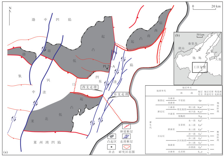
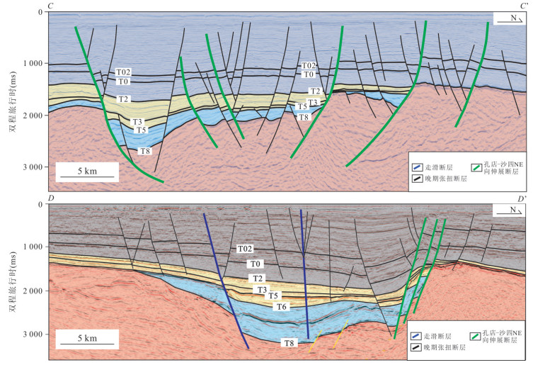
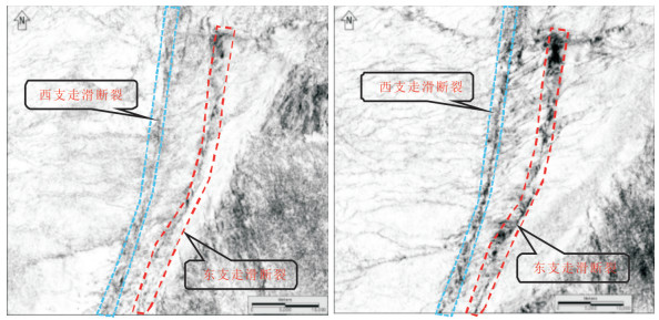
The eastern Huanghekou Sag was a typical hydrocarbon-rich sag in Bohai Bay Basin. The fault system of the sag were studied based on new 3D seismic interpretation. A combination of structure interpretation and tectonophisics simulation were applied to reconstruct the tectonic evolution. The results showed that controlled by strike slip and extensional stress, the studied area developed NNE-NE strike slip fault system and EW-NEE extensional fault system, experiencing four stages: the Ek-Es4 (the Kongdian Formation: The 4th member of the Shahejie Formation) initial extension-twist rifting stage, the Es3 (the 3rd member of the Shahejie Formation) strike slip extension rifting stage, the Es1-2-Ed (the 1st and 2nd member of the Shahejie Formation-the Dongying Formation) strike slip stage, and the Ng-Nm (the Guantao Formation-the Minghuazhen Formation) extension twisting stage. The major strike slip fault developed by activating the NE extensional faults formed during the initial stage. The major extensional fault developed on the basis of SN extensional stress during the strike slip extension rifting stage. During the strike slip stage, extension weakened, the faults of all directions activated due to SN extensional stress and showed strike slip-extension complex deformation. During the extension-twisting stage, some of the earlier major faults activated and in the meanwhile, many new secondary faults formed in Neogene.
The eastern Huanghekou Sag was a typical hydrocarbon-rich sag in Bohai Bay Basin. The fault system of the sag were studied based on new 3D seismic interpretation. A combination of structure interpretation and tectonophisics simulation were applied to reconstruct the tectonic evolution. The results showed that controlled by strike slip and extensional stress, the studied area developed NNE-NE strike slip fault system and EW-NEE extensional fault system, experiencing four stages: the Ek-Es4 (the Kongdian Formation: The 4th member of the Shahejie Formation) initial extension-twist rifting stage, the Es3 (the 3rd member of the Shahejie Formation) strike slip extension rifting stage, the Es1-2-Ed (the 1st and 2nd member of the Shahejie Formation-the Dongying Formation) strike slip stage, and the Ng-Nm (the Guantao Formation-the Minghuazhen Formation) extension twisting stage. The major strike slip fault developed by activating the NE extensional faults formed during the initial stage. The major extensional fault developed on the basis of SN extensional stress during the strike slip extension rifting stage. During the strike slip stage, extension weakened, the faults of all directions activated due to SN extensional stress and showed strike slip-extension complex deformation. During the extension-twisting stage, some of the earlier major faults activated and in the meanwhile, many new secondary faults formed in Neogene.


2021, 46(7): 2403-2422.
doi: 10.3799/dqkx.2020.272
Abstract:
The petrogenesis and geodynamic setting of Early Permian volcanic rocks in eastern Inner Mongolia, hold a key to understanding the amalgamation of Xing'an block and Songnen block. This study carry out LA-ICP-MS zircon U-Pb dating, whole rock major trace and zircon in situ Lu-Hf isotopic analysis of basic-intermediate volcanic rocks of Dashizhai formation in Dashizhai area with the aim of investigating their petrogenesis and unraveling the geodynamic setting of their emplacement, so as to provide more information for constraining the amalgamation process of Xing'an block and Songnen block, and for exploring the tectonic evolution of the eastern part of the Xing'an-Inner Mongolia Orogenic Belt (XMOB). The basic-intermediate volcanic rocks of Dashizhai Formation include metaspilite, metabasalt, clastic basaltic andesite, basaltic andesite, chloritized andesite, amygdaloid andesite, andesitic crystalline tuff, etc. LA-ICP-MS zircon U-Pb ages of 286.0±4.3 Ma (MSWD=0.14) and 286.0±3.3 Ma (MSWD=0.14) from the metaspilite and chloritized andesite uniformly indicate that these basic-intermediate rocks of Dashizhai Formation erupted in the Early Permian, representing a violent tectono-magmatism event. Geochemically, these volcanic rocks are a set of Na rich subalkaline basalt-basaltic andesite-andesite association, most of them are dominated by tholeiitic series, and some of them have both tholeiitic and calc alkaline characteristics. These rocks are characterized by an enrichment in large ion lithophile elements (LILEs, such as Ba, U, K) and light rare earth elements (LREE, La, Ce), and a depletion in high field strength elements (HFSEs, such as Nb and Ta). Most magmatic zircons of the metaspilite and chloritized andesite show positive εHf(t) values (6.68-12.94 and 8.41-12.31 resectively) and similar single-stage model ages (TDM1=438-589 Ma and 413-668 Ma resectively). In summary, the basic-intermediate volcanic rocks of Dashizhai Formation in Dashizhai area are derived from depleted mantle, and experienced fractional crystallization of clinopyroxene, olivine and iron magnesium oxide in the process of magma evolution, and suffered from strong crustal contamination.Combined with the regional geological data, the volcanic rocks of Dashizhai formation in Dashizhai area were formed in the tectonic setting of intracontinental extension rather than subduction background, which indicates that the amalgamation of Xing'an block and Songnen block occurred before the Early Permian. At the same time, by comparing the geochemical characteristics and other geological data of the Early-Middle Permian volcanic rocks in the region, this paper considers that the Early-Middle Permian volcanic rocks in the mid-eastern Inner Mongolia are the products of intracontinental extension, and the regional extension may have originated from the Early Carboniferous.
The petrogenesis and geodynamic setting of Early Permian volcanic rocks in eastern Inner Mongolia, hold a key to understanding the amalgamation of Xing'an block and Songnen block. This study carry out LA-ICP-MS zircon U-Pb dating, whole rock major trace and zircon in situ Lu-Hf isotopic analysis of basic-intermediate volcanic rocks of Dashizhai formation in Dashizhai area with the aim of investigating their petrogenesis and unraveling the geodynamic setting of their emplacement, so as to provide more information for constraining the amalgamation process of Xing'an block and Songnen block, and for exploring the tectonic evolution of the eastern part of the Xing'an-Inner Mongolia Orogenic Belt (XMOB). The basic-intermediate volcanic rocks of Dashizhai Formation include metaspilite, metabasalt, clastic basaltic andesite, basaltic andesite, chloritized andesite, amygdaloid andesite, andesitic crystalline tuff, etc. LA-ICP-MS zircon U-Pb ages of 286.0±4.3 Ma (MSWD=0.14) and 286.0±3.3 Ma (MSWD=0.14) from the metaspilite and chloritized andesite uniformly indicate that these basic-intermediate rocks of Dashizhai Formation erupted in the Early Permian, representing a violent tectono-magmatism event. Geochemically, these volcanic rocks are a set of Na rich subalkaline basalt-basaltic andesite-andesite association, most of them are dominated by tholeiitic series, and some of them have both tholeiitic and calc alkaline characteristics. These rocks are characterized by an enrichment in large ion lithophile elements (LILEs, such as Ba, U, K) and light rare earth elements (LREE, La, Ce), and a depletion in high field strength elements (HFSEs, such as Nb and Ta). Most magmatic zircons of the metaspilite and chloritized andesite show positive εHf(t) values (6.68-12.94 and 8.41-12.31 resectively) and similar single-stage model ages (TDM1=438-589 Ma and 413-668 Ma resectively). In summary, the basic-intermediate volcanic rocks of Dashizhai Formation in Dashizhai area are derived from depleted mantle, and experienced fractional crystallization of clinopyroxene, olivine and iron magnesium oxide in the process of magma evolution, and suffered from strong crustal contamination.Combined with the regional geological data, the volcanic rocks of Dashizhai formation in Dashizhai area were formed in the tectonic setting of intracontinental extension rather than subduction background, which indicates that the amalgamation of Xing'an block and Songnen block occurred before the Early Permian. At the same time, by comparing the geochemical characteristics and other geological data of the Early-Middle Permian volcanic rocks in the region, this paper considers that the Early-Middle Permian volcanic rocks in the mid-eastern Inner Mongolia are the products of intracontinental extension, and the regional extension may have originated from the Early Carboniferous.


2021, 46(7): 2423-2448.
doi: 10.3799/dqkx.2020.235
Abstract:
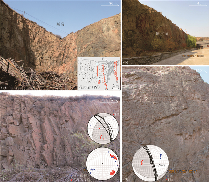
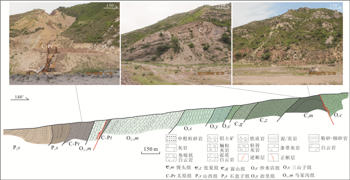
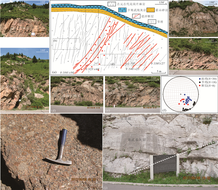
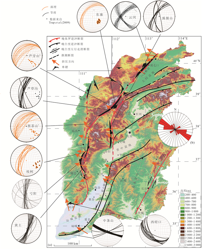
The formation of the Lüliangshan located in the central North China Craton (NCC) is the result of the contraction event in the Late Jurassic-Early Cretaceous. In order to better understand the style, mechanism, background, and time of this deformation, a detailed field survey has been carried out in Lüliangshan area. The previous work of low temperature thermochronology has been collected. The results show that the Lüliangshan is a large basement involved fold system with typical monocline formed in Mesozoic in NCC. The existing foliations (i.e., gneissosity, schistosity, cleavage and joint) in the basement of the Precambrian orogenic belt in the central NCC reactivated to cause the folding of the overlying sedimentary layers during the later east-west shortening. The direction of shortening which resulted in the basement involved folds in the Lüliangshan is uniform across the entire mountain range, i.e., SE (122°)-NW (302°) compression. The mechanism, styles and distributions of monoclines in the Lüliangshan are similar to monoclines in the Laramide orogenic belt in the western North America. The folds including most monoclines in the Lüliangshan were formed in the Late Jurassic and caused by lower-angle subduction of the Paleo-Pacific Plate westwards, which also resulted in the intraplate contraction deformation of the NCC.
The formation of the Lüliangshan located in the central North China Craton (NCC) is the result of the contraction event in the Late Jurassic-Early Cretaceous. In order to better understand the style, mechanism, background, and time of this deformation, a detailed field survey has been carried out in Lüliangshan area. The previous work of low temperature thermochronology has been collected. The results show that the Lüliangshan is a large basement involved fold system with typical monocline formed in Mesozoic in NCC. The existing foliations (i.e., gneissosity, schistosity, cleavage and joint) in the basement of the Precambrian orogenic belt in the central NCC reactivated to cause the folding of the overlying sedimentary layers during the later east-west shortening. The direction of shortening which resulted in the basement involved folds in the Lüliangshan is uniform across the entire mountain range, i.e., SE (122°)-NW (302°) compression. The mechanism, styles and distributions of monoclines in the Lüliangshan are similar to monoclines in the Laramide orogenic belt in the western North America. The folds including most monoclines in the Lüliangshan were formed in the Late Jurassic and caused by lower-angle subduction of the Paleo-Pacific Plate westwards, which also resulted in the intraplate contraction deformation of the NCC.


2021, 46(7): 2449-2465.
doi: 10.3799/dqkx.2020.208
Abstract:
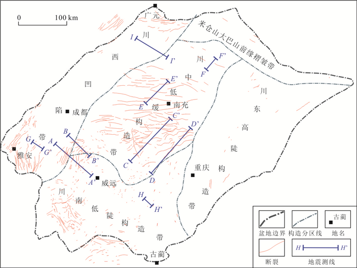
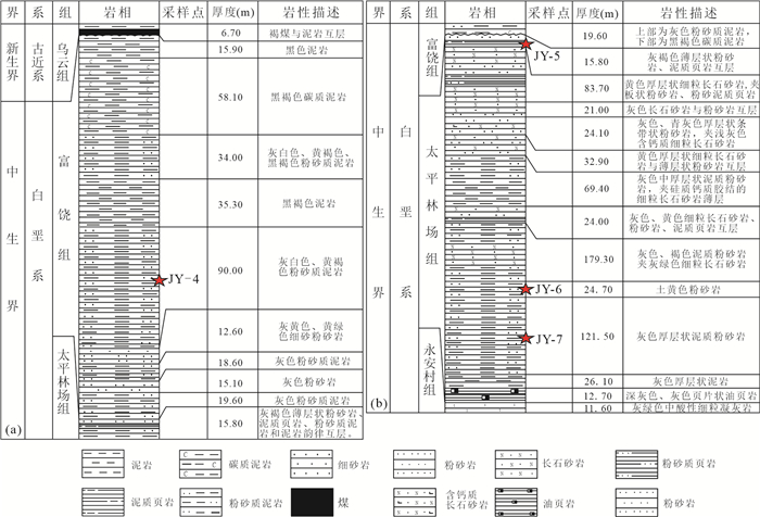
In order to reconstruct the sedimentary tectonic pattern of Wufeng Formation and Longmaxi Formation in the northern margin of Sichuan Basin, the Wufeng Formation and Longmaxi Formation in the Micangshan-Dabashan area of the northern margin of Sichuan Basin were taken as the research objects. The stratigraphic framework correlation and sedimentary facies analysis were carried out, and Mo/TOC and Al-Co[EF]×Mn[EF] geochemical indicators were used to determine the degree of water mass restricted in the sedimentary period. It is found that near the uplift area, controlled by the material supply and sedimentary space, the thickness of strata varies greatly, and the thickness of black shale is smaller as a whole. However, far away from the uplift area, the black shale gradually thickens from west to east and the TOC content increases under the control of the upwelling at the continental margin and intracontinental depression.Research shows that: (1) The Wufeng Formation in Micangshan area was deposited in Fucheng of Nanzheng County, and Qiaoting of Nanjiang County, in the intersection area of two kinds of upwelling currents, which were influenced by the upwelling currents for a long time. The sedimentary period of Longmaxi Formation was mainly influenced by the Xixiang Rise, which resulted in the uplift of Wangcang and Nanjiang areas into islands, with the thickest deposition in Well Mashen 1. (2) Generally, the Wufeng Formation in the Dabashan front and the western Hubei-eastern Chongqing area presents a pattern of uplift-depression alternation. Due to the continuous compression of the Cathaysian block from SE to NW, the Shizhu-Wuxi line subsided continuously during the sedimentary period of the Longmaxi Formation, resulting in a relatively thick stratigraphic deposition.
In order to reconstruct the sedimentary tectonic pattern of Wufeng Formation and Longmaxi Formation in the northern margin of Sichuan Basin, the Wufeng Formation and Longmaxi Formation in the Micangshan-Dabashan area of the northern margin of Sichuan Basin were taken as the research objects. The stratigraphic framework correlation and sedimentary facies analysis were carried out, and Mo/TOC and Al-Co[EF]×Mn[EF] geochemical indicators were used to determine the degree of water mass restricted in the sedimentary period. It is found that near the uplift area, controlled by the material supply and sedimentary space, the thickness of strata varies greatly, and the thickness of black shale is smaller as a whole. However, far away from the uplift area, the black shale gradually thickens from west to east and the TOC content increases under the control of the upwelling at the continental margin and intracontinental depression.Research shows that: (1) The Wufeng Formation in Micangshan area was deposited in Fucheng of Nanzheng County, and Qiaoting of Nanjiang County, in the intersection area of two kinds of upwelling currents, which were influenced by the upwelling currents for a long time. The sedimentary period of Longmaxi Formation was mainly influenced by the Xixiang Rise, which resulted in the uplift of Wangcang and Nanjiang areas into islands, with the thickest deposition in Well Mashen 1. (2) Generally, the Wufeng Formation in the Dabashan front and the western Hubei-eastern Chongqing area presents a pattern of uplift-depression alternation. Due to the continuous compression of the Cathaysian block from SE to NW, the Shizhu-Wuxi line subsided continuously during the sedimentary period of the Longmaxi Formation, resulting in a relatively thick stratigraphic deposition.


2021, 46(7): 2466-2480.
doi: 10.3799/dqkx.2020.238
Abstract:
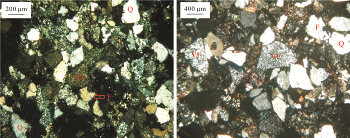
The characteristics of volcanic complex reservoirs are unique. In order to reveal the characteristics of these reservoirs and expand the exploration ideas, this paper discusses the characteristics of volcanic rocks and their control on the reservoirs. The lithofacies characteristics and development patterns of volcanic rocks were studied by combining thin section, drilling, logging and seismic data. In addition, basalt and tuff were identified quantitatively by means of rock electrical analysis and logging response characteristics. Based on this, the boundary limits of wave impedance of volcanic rock and sand-mudstone are determined by geophysical method, and the seismic characteristics of wave impedance inversion under logging constraints and disorderly reflection in local well area of Dong Ying Formation are used to describe and predict volcanic rock distribution under complex lithological background. Guan Tao Formation is a large-scale volcanic activity period which contributes to development of a large set of volcanic rock, mainly distributing in the south and southwest of the oil field. The slightly activity of the Volcanoes of Dong Ying and Sha He Jie Groups results in a small amount of volcanic rock developed, which is scattered in the local well area of oil field. The closer to main faulted area, the thicker volcanic rocks are, so it can be inferred that development and distribution of volcanic rocks controlled by main faults. Volcanic rock is tight, which can serve as reservoir cap rock and lateral sealing layer, occupying the sedimentary space of exotic clastic rocks. Volcanic rock is a necessary condition for oil and gas accumulation in the study area, but it will segment trap, control and restrict the distribution of clastic rock, limit the type and scale of reservoir, as well as have certain effect on the crude oil property. The research results reveal a new exploration area of Cenozoic in Bohai Bay Basin, which can also provide an example for reservoir evaluation and development deployment.
The characteristics of volcanic complex reservoirs are unique. In order to reveal the characteristics of these reservoirs and expand the exploration ideas, this paper discusses the characteristics of volcanic rocks and their control on the reservoirs. The lithofacies characteristics and development patterns of volcanic rocks were studied by combining thin section, drilling, logging and seismic data. In addition, basalt and tuff were identified quantitatively by means of rock electrical analysis and logging response characteristics. Based on this, the boundary limits of wave impedance of volcanic rock and sand-mudstone are determined by geophysical method, and the seismic characteristics of wave impedance inversion under logging constraints and disorderly reflection in local well area of Dong Ying Formation are used to describe and predict volcanic rock distribution under complex lithological background. Guan Tao Formation is a large-scale volcanic activity period which contributes to development of a large set of volcanic rock, mainly distributing in the south and southwest of the oil field. The slightly activity of the Volcanoes of Dong Ying and Sha He Jie Groups results in a small amount of volcanic rock developed, which is scattered in the local well area of oil field. The closer to main faulted area, the thicker volcanic rocks are, so it can be inferred that development and distribution of volcanic rocks controlled by main faults. Volcanic rock is tight, which can serve as reservoir cap rock and lateral sealing layer, occupying the sedimentary space of exotic clastic rocks. Volcanic rock is a necessary condition for oil and gas accumulation in the study area, but it will segment trap, control and restrict the distribution of clastic rock, limit the type and scale of reservoir, as well as have certain effect on the crude oil property. The research results reveal a new exploration area of Cenozoic in Bohai Bay Basin, which can also provide an example for reservoir evaluation and development deployment.


2021, 46(7): 2481-2493.
doi: 10.3799/dqkx.2020.226
Abstract:
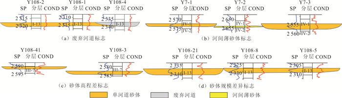
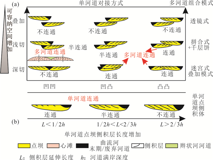
In order to explain the problems of Dongying Formation in Yu108 and Yu24 fault blocks in Yuke Oilfield, such as complicated oil-water relationship, non-correspondence of injection-production and efficiency of water-injection development. Based on the study of microfacies and reservoir architecture of the fluvial reservoir of Dongying Formation in Yuke oilfield by using core, well loggings, seismics, lab analysis, production dynamics and reservoir monitoring data, this paper proposes two connection patterns of single channel and point bar. Combined with the production dynamic analysis, an oil reservoir unit classification scheme is proposed, consisting of four reservoir units and five combinations of reservoir units. In this paper, three examples are given to prove the reservoir units divided based on the study of sedimentary microfacies and reservoir architecture can not only explain the problems existing in the development of Dongying Formation reservoirs in the Yuke Oilfield, but also provide theoretical basis for fine development and adjustment of reservoirs and improvement of reservoir development level.
In order to explain the problems of Dongying Formation in Yu108 and Yu24 fault blocks in Yuke Oilfield, such as complicated oil-water relationship, non-correspondence of injection-production and efficiency of water-injection development. Based on the study of microfacies and reservoir architecture of the fluvial reservoir of Dongying Formation in Yuke oilfield by using core, well loggings, seismics, lab analysis, production dynamics and reservoir monitoring data, this paper proposes two connection patterns of single channel and point bar. Combined with the production dynamic analysis, an oil reservoir unit classification scheme is proposed, consisting of four reservoir units and five combinations of reservoir units. In this paper, three examples are given to prove the reservoir units divided based on the study of sedimentary microfacies and reservoir architecture can not only explain the problems existing in the development of Dongying Formation reservoirs in the Yuke Oilfield, but also provide theoretical basis for fine development and adjustment of reservoirs and improvement of reservoir development level.


2021, 46(7): 2494-2506.
doi: 10.3799/dqkx.2020.257
Abstract:
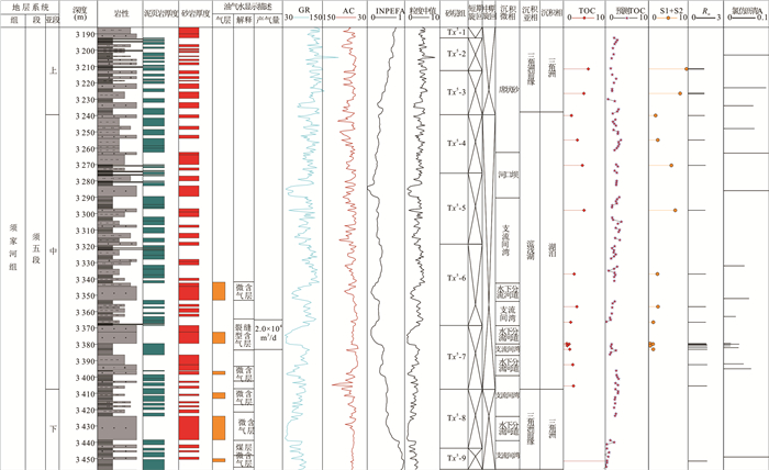
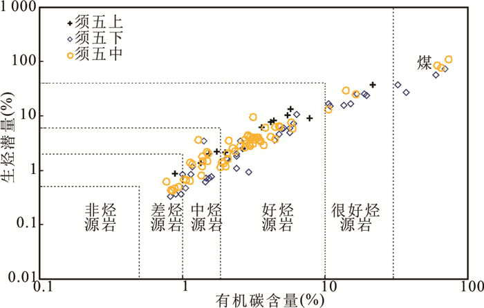
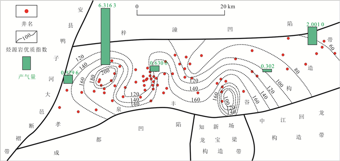
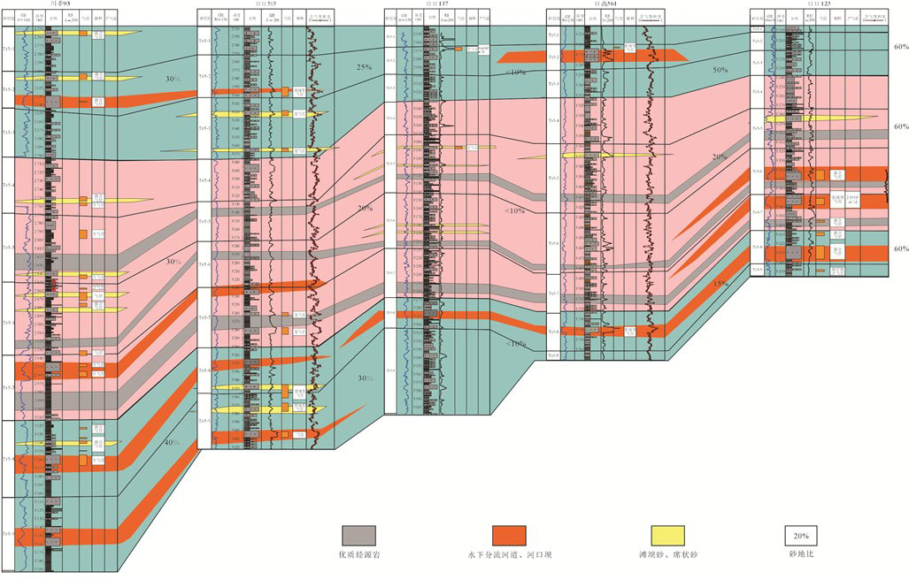
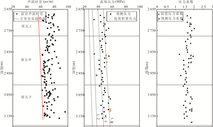
Xujiahe Formation of the Upper Triassic is the main source rock series of the West Sichuan depression, while Xujiahe Formation of the Xiaoquan-Fenggu structural belt is a new field of exploration and development of tight sandstone gas in the West Sichuan depression. Based on the data of geology, logging, drilling and analysis, combined with basin simulation technology, and the analysis of source rock, reservoir characteristics and its development structure sedimentary background in the fifth member of Xujiahe Formation, Xiaoquan Fenggu structural belt, this paper discusses the main controlling factors of reservoir formation in the fifth member of Xujiahe Formation, and establishes the corresponding model. The shale of Xuwu member is continuously and stably distributed, with high organic matter abundance. The type of organic matter is mainly Ⅲ, which is generally in the stage of maturity to high maturity. The sandstone reservoir is generally ultra-low porosity and ultra-low permeability tight reservoir, and the sedimentary facies is mainly delta front subfacies. The main controlling factor of hydrocarbon accumulation in Xuwu member is that the source rock controls the range and scale of gas reservoir, the favorable facies zone determines the location of high quality reservoir, the source reservoir configuration relationship controls the degree of oil and gas enrichment, and the abnormal high pressure is effectively preservation and reservoir reconstruction; the accumulation mode is summarized as short-distance vertical superposition accumulation mode in the source.
Xujiahe Formation of the Upper Triassic is the main source rock series of the West Sichuan depression, while Xujiahe Formation of the Xiaoquan-Fenggu structural belt is a new field of exploration and development of tight sandstone gas in the West Sichuan depression. Based on the data of geology, logging, drilling and analysis, combined with basin simulation technology, and the analysis of source rock, reservoir characteristics and its development structure sedimentary background in the fifth member of Xujiahe Formation, Xiaoquan Fenggu structural belt, this paper discusses the main controlling factors of reservoir formation in the fifth member of Xujiahe Formation, and establishes the corresponding model. The shale of Xuwu member is continuously and stably distributed, with high organic matter abundance. The type of organic matter is mainly Ⅲ, which is generally in the stage of maturity to high maturity. The sandstone reservoir is generally ultra-low porosity and ultra-low permeability tight reservoir, and the sedimentary facies is mainly delta front subfacies. The main controlling factor of hydrocarbon accumulation in Xuwu member is that the source rock controls the range and scale of gas reservoir, the favorable facies zone determines the location of high quality reservoir, the source reservoir configuration relationship controls the degree of oil and gas enrichment, and the abnormal high pressure is effectively preservation and reservoir reconstruction; the accumulation mode is summarized as short-distance vertical superposition accumulation mode in the source.


2021, 46(7): 2507-2514.
doi: 10.3799/dqkx.2018.322
Abstract:
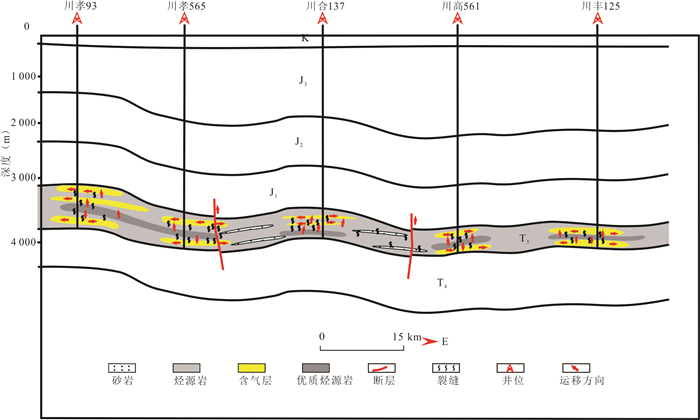
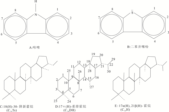
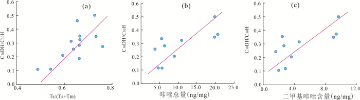
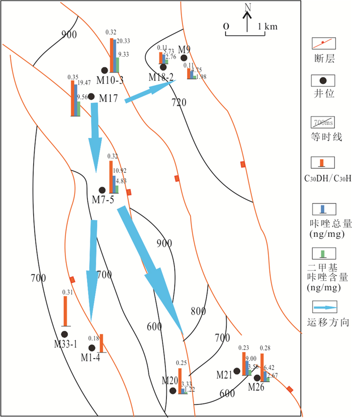
Based on the differences in thermal stability of C30 diahopane(C30DH) and C30 hopane(C30H), this paper studied the feasibility of C30DH/C30H in tracing oil migration orientation and filling pathways.The result shows that the thermal stability of C30DH is considered to be higher than C30H, C30DH/C30H parameters have maturity properties. Meanwhile, contrast C30DH/C30H parameters with carbazoles, found that the C30DH/C30H parameters and carbazoles have great positive correlation. Indicate that the C30DH/C30H parameters not only is a good thermal maturity parameters but also a good in hydrocarbon charging migration. M oilfield is located in the eastern Fula depression. The oils are all normal and the source materials are dual contributions of lower hydrobiont and terrigenous higher plants, the environment is fresh to slight saline water oxidizing to reducing sedimentation, belong to the same group of crude oil.Using C30DH/C30H parameter tracer M oilfield reservoir group of hydrocarbon charging migration direction in Fula depression.The migration path of oil and gas is mainly from north to south, and it also develops from west to east. The classic carbazoles parameter also verified the C30DH/C30H tracer the accuracy of the oil and gas migration. Preliminary results show that C30DH/C30H arameters is an effective parameter for tracer oil filling way.
Based on the differences in thermal stability of C30 diahopane(C30DH) and C30 hopane(C30H), this paper studied the feasibility of C30DH/C30H in tracing oil migration orientation and filling pathways.The result shows that the thermal stability of C30DH is considered to be higher than C30H, C30DH/C30H parameters have maturity properties. Meanwhile, contrast C30DH/C30H parameters with carbazoles, found that the C30DH/C30H parameters and carbazoles have great positive correlation. Indicate that the C30DH/C30H parameters not only is a good thermal maturity parameters but also a good in hydrocarbon charging migration. M oilfield is located in the eastern Fula depression. The oils are all normal and the source materials are dual contributions of lower hydrobiont and terrigenous higher plants, the environment is fresh to slight saline water oxidizing to reducing sedimentation, belong to the same group of crude oil.Using C30DH/C30H parameter tracer M oilfield reservoir group of hydrocarbon charging migration direction in Fula depression.The migration path of oil and gas is mainly from north to south, and it also develops from west to east. The classic carbazoles parameter also verified the C30DH/C30H tracer the accuracy of the oil and gas migration. Preliminary results show that C30DH/C30H arameters is an effective parameter for tracer oil filling way.


2021, 46(7): 2515-2528.
doi: 10.3799/dqkx.2020.179
Abstract:
Nantuo Formation directly overlies the Liantuo Formation in the Three Gorges area where the standard section for defining Sinian System is located. However, there is the absence of deposits of Sturtian glaciation and interglaciation below the Nantuo Formation. The interpretation for the depositional absence remains unclear. Our works focused on the boundary strata between the Nantuo Formation and the Liantuo Formation using sedimentological method in studying the contemporaryglacial deposits. The results show that there is a layer of purplish red diamictites between the Nantuo Formation and the Liantuo Formation in study area. The orientation, shape, roundness, lithology of the clasts and microscopic structure of diamictites in the boundary strata are obviously different from the typical Nantuo diamictites. In addition, subglacial deformational structure on microscale can be recognized at Qinlinkou section. We conclude that the inconformity between the Nantuo Formation and the Liantuo Formation is caused by subglacial erosion, and the Nantuo Formation may just record the retreat deposition of ice sheet from its glacial maximum.
Nantuo Formation directly overlies the Liantuo Formation in the Three Gorges area where the standard section for defining Sinian System is located. However, there is the absence of deposits of Sturtian glaciation and interglaciation below the Nantuo Formation. The interpretation for the depositional absence remains unclear. Our works focused on the boundary strata between the Nantuo Formation and the Liantuo Formation using sedimentological method in studying the contemporaryglacial deposits. The results show that there is a layer of purplish red diamictites between the Nantuo Formation and the Liantuo Formation in study area. The orientation, shape, roundness, lithology of the clasts and microscopic structure of diamictites in the boundary strata are obviously different from the typical Nantuo diamictites. In addition, subglacial deformational structure on microscale can be recognized at Qinlinkou section. We conclude that the inconformity between the Nantuo Formation and the Liantuo Formation is caused by subglacial erosion, and the Nantuo Formation may just record the retreat deposition of ice sheet from its glacial maximum.


2021, 46(7): 2529-2543.
doi: 10.3799/dqkx.2020.280
Abstract:
The division and correlation of the Liantuo Formation and its equivalent stratigraphic units in the Mid-Yangtze block has been one of the key problems in study of the Nanhuan System (Cryogenian) in China. In the early stage of the Neoproterozoic rift basin, tectonic-sedimentary differentiation, which made the stratigraphic sequence of the basin margin incomplete. Due to the excessive reliance on the lithostratigraphic unit comparison, which are typically related to the stratigraphic correlation between the Liantuo Formation and the Banxi Group. The geochronology and paleoenvironment of the Liantuo Formation are still highly controversial. An integrated approach of facies analysis, paleogeography, and geochronology provides new insights into the sedimentology and paleogeography in the Precambrian. The Liantuo Formation was deposited ca. 790-720 Ma, which was equivalent to the Wuqiangxi Formation in the middle-upper part of the Banxi Group. Due to the uplift and subsidence of the earth's crust, the sea water gradually overflows from south to north. Different sedimentary units of the Liantuo Formation, continental, transitional and Marine facies, have been developed from north to south in the Mid-Yangtze block. Detrital zircons from the Liantuo and Xiuning formations record that the basin experienced continuous heat uplift and stratigraphic denudation in 780-760Ma during the deposition of the Liantuo Formation, which reveals the important information about the convergence and rift events of the Yangtze and Cathaysia blocks in south China.
The division and correlation of the Liantuo Formation and its equivalent stratigraphic units in the Mid-Yangtze block has been one of the key problems in study of the Nanhuan System (Cryogenian) in China. In the early stage of the Neoproterozoic rift basin, tectonic-sedimentary differentiation, which made the stratigraphic sequence of the basin margin incomplete. Due to the excessive reliance on the lithostratigraphic unit comparison, which are typically related to the stratigraphic correlation between the Liantuo Formation and the Banxi Group. The geochronology and paleoenvironment of the Liantuo Formation are still highly controversial. An integrated approach of facies analysis, paleogeography, and geochronology provides new insights into the sedimentology and paleogeography in the Precambrian. The Liantuo Formation was deposited ca. 790-720 Ma, which was equivalent to the Wuqiangxi Formation in the middle-upper part of the Banxi Group. Due to the uplift and subsidence of the earth's crust, the sea water gradually overflows from south to north. Different sedimentary units of the Liantuo Formation, continental, transitional and Marine facies, have been developed from north to south in the Mid-Yangtze block. Detrital zircons from the Liantuo and Xiuning formations record that the basin experienced continuous heat uplift and stratigraphic denudation in 780-760Ma during the deposition of the Liantuo Formation, which reveals the important information about the convergence and rift events of the Yangtze and Cathaysia blocks in south China.


2021, 46(7): 2544-2554.
doi: 10.3799/dqkx.2020.287
Abstract:
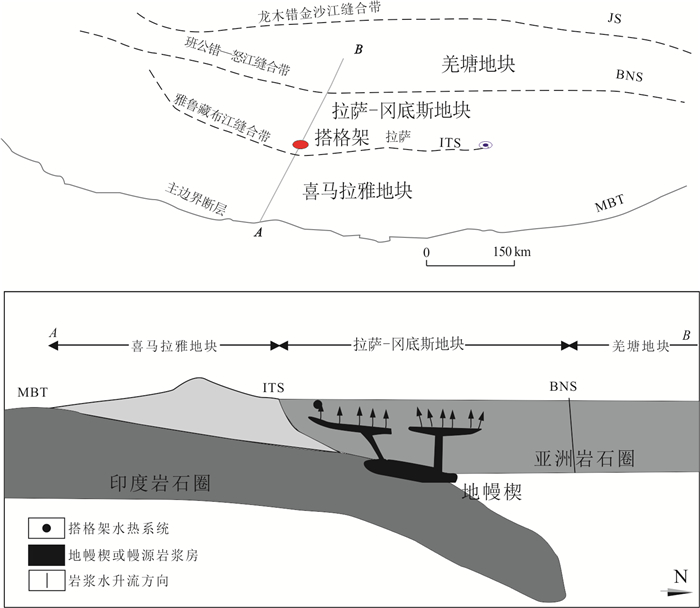
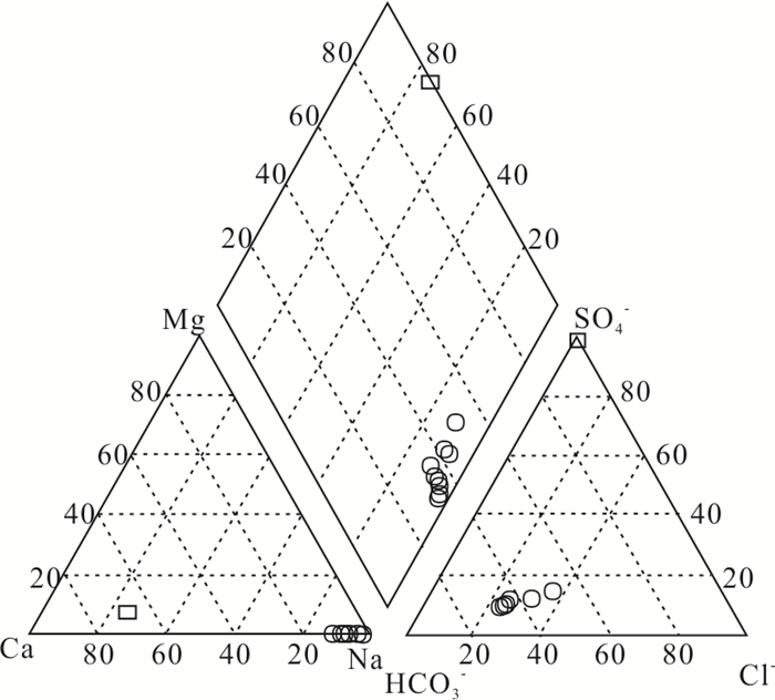
Extremely high concentrations of tungsten was detected in the hot springs discharged from the Daggyai hydrothermal area, Tibet, and their tungsten to molybdenum ratios are much higher than common natural waters as well. A hydrogeochemical study of typical Daggyai hot springs was carried out, based on which it was found that the tungsten concentrations of the neutral springs are significantly higher than those of the acid springs. The neutral hot springs at Daggyai were formed via the adiabatic cooling or conductive cooling of the parent geothermal fluids ascending from the deep levels to the surface, and the tungsten in these waters is primarily from the contribution of magmatic fluids. In contrast, the slightly acid hot springs are basically a mixture of the steam-heated acid waters and neutral geothermal waters, and the dilution of tungsten-depleted steam-heated waters lowered the tungsten concentrations of these springs to various degrees. In geothermal systems, tungsten behaves generally like chloride, a typical conservative component, and is difficult to precipitate from geothermal water or to be adsorbed by reservoir rocks. However, molybdenum is prone to precipitate from sulfide-rich Daggyai geothermal waters as the form of molybdenite, resulting in the high tungsten to molybdenum ratios of the Daggyai hot springs. Moreover, although sulfide exists in the Daggyai geothermal waters, the major species of tungsten is tungstate instead of thiotungstates. The formation of trace thiotungstates has little effects on the tungsten-involved hydrogeochemical processes.
Extremely high concentrations of tungsten was detected in the hot springs discharged from the Daggyai hydrothermal area, Tibet, and their tungsten to molybdenum ratios are much higher than common natural waters as well. A hydrogeochemical study of typical Daggyai hot springs was carried out, based on which it was found that the tungsten concentrations of the neutral springs are significantly higher than those of the acid springs. The neutral hot springs at Daggyai were formed via the adiabatic cooling or conductive cooling of the parent geothermal fluids ascending from the deep levels to the surface, and the tungsten in these waters is primarily from the contribution of magmatic fluids. In contrast, the slightly acid hot springs are basically a mixture of the steam-heated acid waters and neutral geothermal waters, and the dilution of tungsten-depleted steam-heated waters lowered the tungsten concentrations of these springs to various degrees. In geothermal systems, tungsten behaves generally like chloride, a typical conservative component, and is difficult to precipitate from geothermal water or to be adsorbed by reservoir rocks. However, molybdenum is prone to precipitate from sulfide-rich Daggyai geothermal waters as the form of molybdenite, resulting in the high tungsten to molybdenum ratios of the Daggyai hot springs. Moreover, although sulfide exists in the Daggyai geothermal waters, the major species of tungsten is tungstate instead of thiotungstates. The formation of trace thiotungstates has little effects on the tungsten-involved hydrogeochemical processes.


2021, 46(7): 2555-2564.
doi: 10.3799/dqkx.2020.195
Abstract:
Groundwater discharge plays an important role in lake water and nutrient mass balance, for which the key is to quantify lacustrine groundwater discharge (LGD). However, the temporal variation of LGD has been poorly known. In response to this scientific problem, this study takes the important lake in the middle reaches of the Yangtze River-Dongting Lake as an example. By collecting hydrological and meteorological data from the Dongting Lake basin in 1996-2017, the contribution of groundwater discharge to Dongting Lake and the temporal variation of LGD rate were determined based on the mass balance model. The results indicated that: (1) The LGD volume during the dry season was (0.17-1.51)×108 m3/d, the LGD rate was 38.74-207.26 mm/d, and the contribution of LGD to Dongting Lake was 8.70%-30.37%; (2) the LGD volume, rate and its contribution to Dongting Lake showed a decreasing tendency during 2003-2010 and an increasing tendency during 2010-2017, and the LGD from the impoundment of the Three Gorges Reservoir to the completion of the Three Gorges Project was significantly lower than that before the impoundment of the Three Gorges Reservoir and the completion of the Three Gorges Project; (3) the changes of the Yangtze River stage and groundwater table induced by the operation of the Three Gorges Project may be an important cause for the temporal variability of LGD. This study provides a new understanding of the water balance in the Dongting Lake area, as well as the theoretical support for the future utilization of water resources and regional ecological security management in the Dongting Lake area.
Groundwater discharge plays an important role in lake water and nutrient mass balance, for which the key is to quantify lacustrine groundwater discharge (LGD). However, the temporal variation of LGD has been poorly known. In response to this scientific problem, this study takes the important lake in the middle reaches of the Yangtze River-Dongting Lake as an example. By collecting hydrological and meteorological data from the Dongting Lake basin in 1996-2017, the contribution of groundwater discharge to Dongting Lake and the temporal variation of LGD rate were determined based on the mass balance model. The results indicated that: (1) The LGD volume during the dry season was (0.17-1.51)×108 m3/d, the LGD rate was 38.74-207.26 mm/d, and the contribution of LGD to Dongting Lake was 8.70%-30.37%; (2) the LGD volume, rate and its contribution to Dongting Lake showed a decreasing tendency during 2003-2010 and an increasing tendency during 2010-2017, and the LGD from the impoundment of the Three Gorges Reservoir to the completion of the Three Gorges Project was significantly lower than that before the impoundment of the Three Gorges Reservoir and the completion of the Three Gorges Project; (3) the changes of the Yangtze River stage and groundwater table induced by the operation of the Three Gorges Project may be an important cause for the temporal variability of LGD. This study provides a new understanding of the water balance in the Dongting Lake area, as well as the theoretical support for the future utilization of water resources and regional ecological security management in the Dongting Lake area.


2021, 46(7): 2565-2582.
doi: 10.3799/dqkx.2020.230
Abstract:
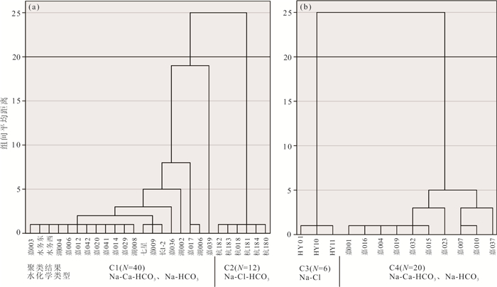
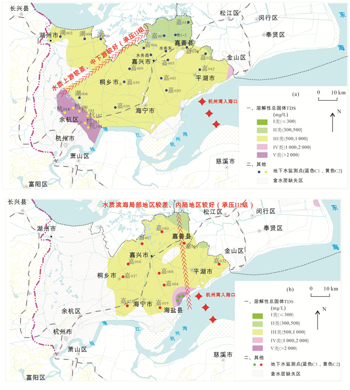
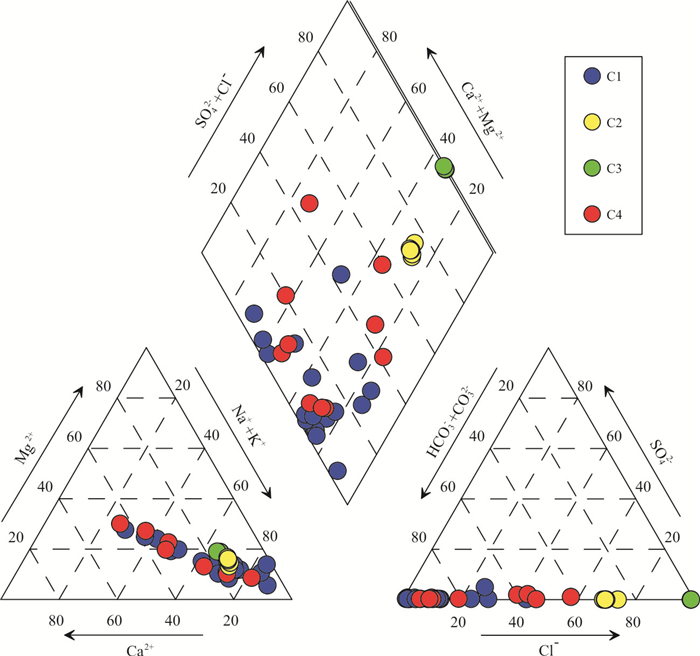
The hydrogeochemical evolution of groundwater flow system in the coastal plainis a complicated process which is influenced by both ancientseawater intrusion and modern anthropogenic activities. However, at present few of previous studies specially investigated on it.In this study, taking the Hangjiahu Plain as an example, the multivariate statistics and hydrochemical analysis methods are used to interpret the hydrochemical data of 78 water samples from deep confined aquifers. Results show that hydrogeochemicalzones of this typical coastal plain can be classified as the ancient seawater intrusionzone, salinized zone and runoff-discharge zone, with the hydrochemical type of Na-Cl-HCO3, Na-HCO3and Na-Ca-HCO3, and Na-Cl, respectively.The dominant factors of groundwaterhydrogeochemical evolution of this coastal plain were seawater invasion and ion exchange, natural rock dissolution and anthropogenic activities. No obvious groundwater flow system hierarchy was foundin the coastal plain. There is a typical pattern of hydrogeochemical evolutionoccurring. Such evolutionis constituted with the following three stages: (1) the formation stage of original fresh water, (2) the salinization stage by ancientseawater invasion, and (3) the modernseawater invasion stage induced by human over pumping. Moreover, anthropogenic activitieshave replaced natural progresses and become the dominant factor on coastal hydrogeochemical evolution.
The hydrogeochemical evolution of groundwater flow system in the coastal plainis a complicated process which is influenced by both ancientseawater intrusion and modern anthropogenic activities. However, at present few of previous studies specially investigated on it.In this study, taking the Hangjiahu Plain as an example, the multivariate statistics and hydrochemical analysis methods are used to interpret the hydrochemical data of 78 water samples from deep confined aquifers. Results show that hydrogeochemicalzones of this typical coastal plain can be classified as the ancient seawater intrusionzone, salinized zone and runoff-discharge zone, with the hydrochemical type of Na-Cl-HCO3, Na-HCO3and Na-Ca-HCO3, and Na-Cl, respectively.The dominant factors of groundwaterhydrogeochemical evolution of this coastal plain were seawater invasion and ion exchange, natural rock dissolution and anthropogenic activities. No obvious groundwater flow system hierarchy was foundin the coastal plain. There is a typical pattern of hydrogeochemical evolutionoccurring. Such evolutionis constituted with the following three stages: (1) the formation stage of original fresh water, (2) the salinization stage by ancientseawater invasion, and (3) the modernseawater invasion stage induced by human over pumping. Moreover, anthropogenic activitieshave replaced natural progresses and become the dominant factor on coastal hydrogeochemical evolution.


2021, 46(7): 2583-2593.
doi: 10.3799/dqkx.2020.236
Abstract:
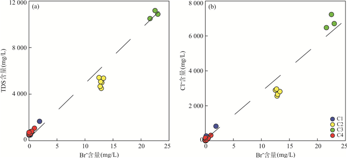
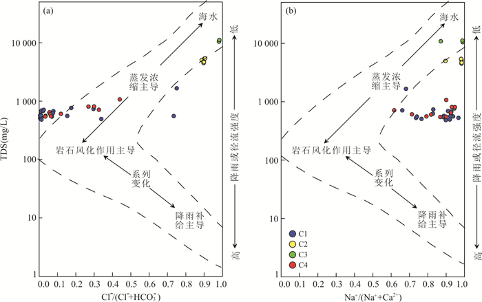
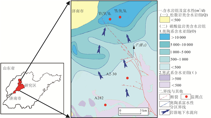
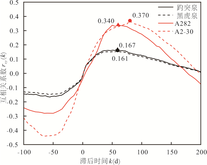
Karst aquifers are characterized by highheterogeneity and spatial variability of their media. Time-series analysis of precipitation and waterlevel (as input and output functions), including correlation, spectrum analysis, were applied to the Jinan karst spring system in Shandong Province, in order to study the hydrodynamic behavior and hydraulic properties of the aquifer system. Autocorrelation and cross-correlation analysis showed that the sensitivity of the system to precipitation input signal decreased gradually from the recharge area to the discharge area, but the memory effect increased gradually. Phase analysis results show that the response of water level to precipitation signal in Jinan spring area lags behind. The lag time from recharge area to discharge area gradually prolongs, and the recharge area has better linear correlation. The results show that the quick flow accounts for about 20%-30% of the subsurface flow in the recharge zone, and the ratio is reduced to 2.5%-10.0% in the discharge zone. The fluctuation of water level in karst system is mainly affected by the internal structure of karstic medium. The karstification degree of the aquifer in Jinan is fairly low, and groundwater movement is dominated by matrix flow.
Karst aquifers are characterized by highheterogeneity and spatial variability of their media. Time-series analysis of precipitation and waterlevel (as input and output functions), including correlation, spectrum analysis, were applied to the Jinan karst spring system in Shandong Province, in order to study the hydrodynamic behavior and hydraulic properties of the aquifer system. Autocorrelation and cross-correlation analysis showed that the sensitivity of the system to precipitation input signal decreased gradually from the recharge area to the discharge area, but the memory effect increased gradually. Phase analysis results show that the response of water level to precipitation signal in Jinan spring area lags behind. The lag time from recharge area to discharge area gradually prolongs, and the recharge area has better linear correlation. The results show that the quick flow accounts for about 20%-30% of the subsurface flow in the recharge zone, and the ratio is reduced to 2.5%-10.0% in the discharge zone. The fluctuation of water level in karst system is mainly affected by the internal structure of karstic medium. The karstification degree of the aquifer in Jinan is fairly low, and groundwater movement is dominated by matrix flow.


2021, 46(7): 2594-2608.
doi: 10.3799/dqkx.2020.207
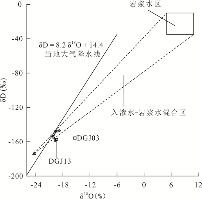
Abstract:
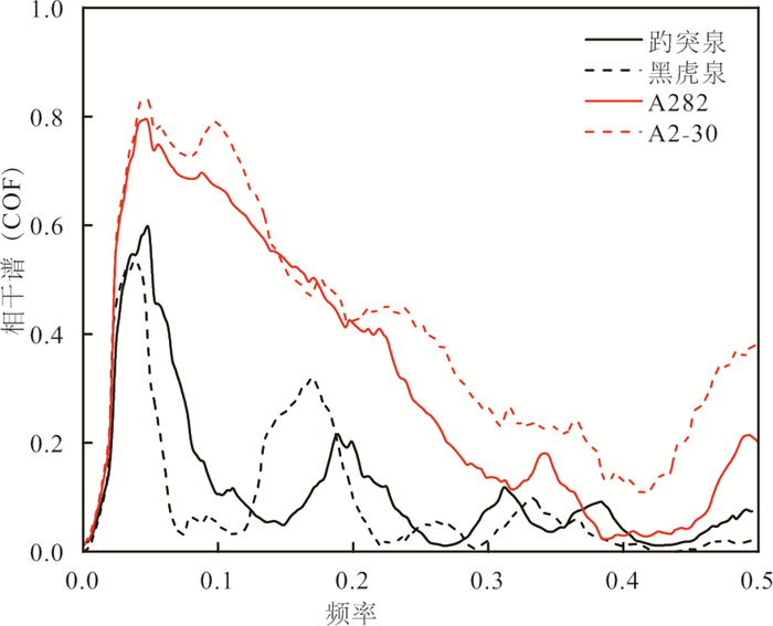
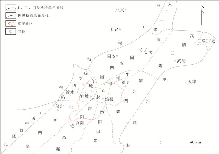
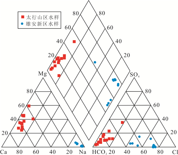
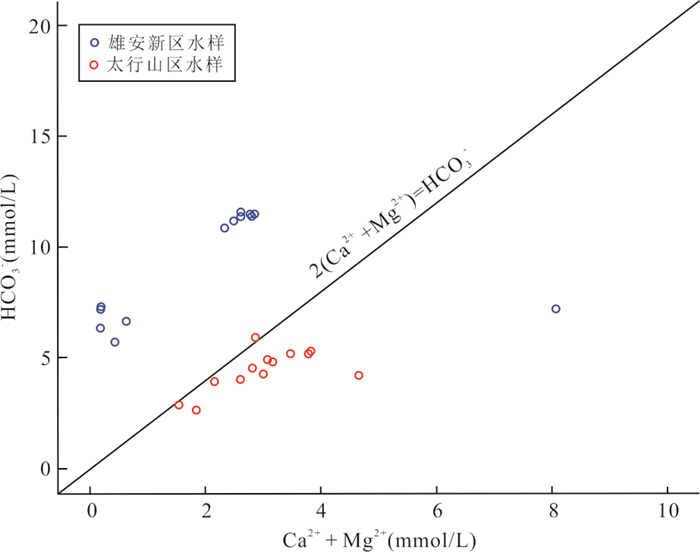
There are abundant geothermal resources in Wumishan Formation of Jixian system in Xiong'an New Area. The study of the hydrogeochemical characteristics of geothermal water can be used to analyze the mechanism of geothermal resources, which is of great significance in the deep of Xiong'an New Area. Based on the analysis of hydrochemical and isotopic data that tested from 26 geothermal water samples of Wumishan Formation in Taihang Mountain-Xiong'an New Area, this paper studies the source of geothermalwater supply and cyclic process of deep geothermal. The results show that HCO3-Ca·Mg is the main hydrochemical type of geothermal water in Taihang Mountain, while Cl·HCO3-Na is the main hydrochemical type in Xiong'an New Area. The geothermal water infiltrates through faults and fractures, accompanied by mineral precipitation and dissolution in the process of long-distance migration, and the interaction between water and rock gradually increases. The depth of deep thermal cycle is 2 880.26-4 143.42 m, with an average value of 3 700 m, and the temperature of deep thermal reservoir is about 160 ℃. The average temperature (lower limit temperature) of thermal reservoir at 750-2 100 m is about 70 ℃ due to the effect of conduction cooling and mixing of 42%-67% cold water during the deep rise of geothermal water.It belongs to convection-conduction geothermal system.
There are abundant geothermal resources in Wumishan Formation of Jixian system in Xiong'an New Area. The study of the hydrogeochemical characteristics of geothermal water can be used to analyze the mechanism of geothermal resources, which is of great significance in the deep of Xiong'an New Area. Based on the analysis of hydrochemical and isotopic data that tested from 26 geothermal water samples of Wumishan Formation in Taihang Mountain-Xiong'an New Area, this paper studies the source of geothermalwater supply and cyclic process of deep geothermal. The results show that HCO3-Ca·Mg is the main hydrochemical type of geothermal water in Taihang Mountain, while Cl·HCO3-Na is the main hydrochemical type in Xiong'an New Area. The geothermal water infiltrates through faults and fractures, accompanied by mineral precipitation and dissolution in the process of long-distance migration, and the interaction between water and rock gradually increases. The depth of deep thermal cycle is 2 880.26-4 143.42 m, with an average value of 3 700 m, and the temperature of deep thermal reservoir is about 160 ℃. The average temperature (lower limit temperature) of thermal reservoir at 750-2 100 m is about 70 ℃ due to the effect of conduction cooling and mixing of 42%-67% cold water during the deep rise of geothermal water.It belongs to convection-conduction geothermal system.


2021, 46(7): 2609-2620.
doi: 10.3799/dqkx.2020.203
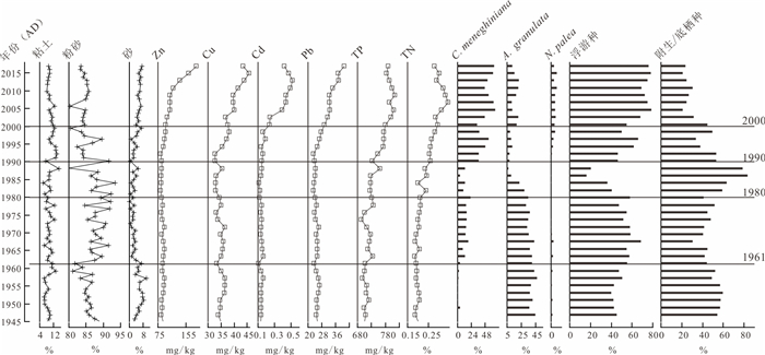
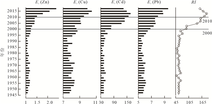
Abstract:
Based on sedimentary proxies (i.e., 210Pb and 137Cs dating, heavy metal nutrient and elements, particle size and diatom dominant species) from sediment core in the northern part of Baiyangdian Lake and documentary date (i.e., hydrology, climate, economic and society statistic from Baoding city and Anxin county), this study reconstructed the eco-environment changes of Baiyangdian Lake during the past 70 years and discussed the main driving factors affecting the succession of dominant diatom species.The results showed heavy metals and nutrients were of lower levels, and the diatom was dominated by Aulacoseira granulate before 1960, which indicated that the lake ecology was in the stage of natural evolution.Around 1960, influenced by hydrological control upstream, TP and TN content in Baiyangdian Lake started to increase slowly, and the indicator species of eutrophication, Cyclotella meneghiniana, increased significantly.Between 1960 and 1990, TP and TN content rose significantly, indicating more nutrient input in the rapid process of agriculturalization, however, the content of heavy metals still remained at a lower level. The diatom assemblages were characterized by the codominance of A. granulate and C. meneghiniana. After 1990, accelerated industrial and agricultural activitiesenriched heavy metals and nutrients, especially after 2000, such enrichment became even more significant.At which point diatom assemblages went through material changes: the dominant species shifted from A. granulate before 1990 to C. meneghiniana after 1990; the heavy metal-tolerant species Nitzschia palea hasbeen on the rise since 2000. According to the redundancy analysis, heavy metals, TP, TN, temperature, wind speed, hydrological conditions were significant factors influencing the succession of three diatom dominant speciesover the past 70 years in Baiyangdian. Heavy metals and nutrients were most important factors on diatom succession. Meanwhile, hydrological conditions, temperature and wind speed also imposed on diatom succession.
Based on sedimentary proxies (i.e., 210Pb and 137Cs dating, heavy metal nutrient and elements, particle size and diatom dominant species) from sediment core in the northern part of Baiyangdian Lake and documentary date (i.e., hydrology, climate, economic and society statistic from Baoding city and Anxin county), this study reconstructed the eco-environment changes of Baiyangdian Lake during the past 70 years and discussed the main driving factors affecting the succession of dominant diatom species.The results showed heavy metals and nutrients were of lower levels, and the diatom was dominated by Aulacoseira granulate before 1960, which indicated that the lake ecology was in the stage of natural evolution.Around 1960, influenced by hydrological control upstream, TP and TN content in Baiyangdian Lake started to increase slowly, and the indicator species of eutrophication, Cyclotella meneghiniana, increased significantly.Between 1960 and 1990, TP and TN content rose significantly, indicating more nutrient input in the rapid process of agriculturalization, however, the content of heavy metals still remained at a lower level. The diatom assemblages were characterized by the codominance of A. granulate and C. meneghiniana. After 1990, accelerated industrial and agricultural activitiesenriched heavy metals and nutrients, especially after 2000, such enrichment became even more significant.At which point diatom assemblages went through material changes: the dominant species shifted from A. granulate before 1990 to C. meneghiniana after 1990; the heavy metal-tolerant species Nitzschia palea hasbeen on the rise since 2000. According to the redundancy analysis, heavy metals, TP, TN, temperature, wind speed, hydrological conditions were significant factors influencing the succession of three diatom dominant speciesover the past 70 years in Baiyangdian. Heavy metals and nutrients were most important factors on diatom succession. Meanwhile, hydrological conditions, temperature and wind speed also imposed on diatom succession.


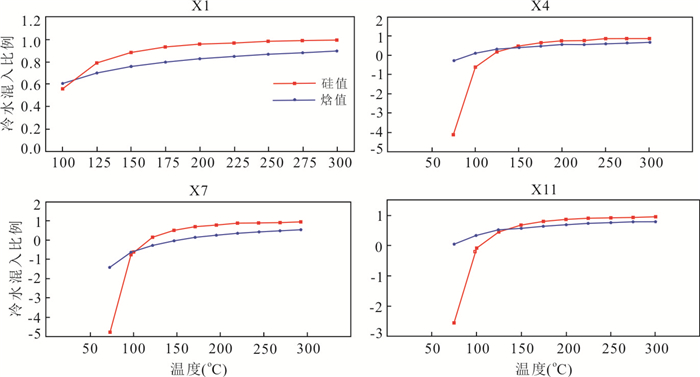
2021, 46(7): 2621-2645.
doi: 10.3799/dqkx.2020.285
Abstract:
Eco-geochemical conditions have an important impact on the quality of characteristic crops. It is of great significance to carry out investigation of the element migration and accumulation characteristics of the bedrock-regolith-soil-plant continuum of the Earth's critical zone for the adaptive evaluation on agricultural planting and the optimization of utilization of agricultural land. Taking the almond producing area in Chengde, Hebei Province as the study area, the quantitative evaluation of element migration in BRSPC was calculated by multiple chemical weathering index, chemical depletion fraction, mass transfer coefficient and bioconcentration factor in clastic rock and volcanic rock formation area combining multiple statistical methods. The results indicate that the element geochemical grade of TK and TFe2O3 were categorized as rich level, Se categorized as moderate level, Cu and Ge categorized as moderate-rich level and TP, TS, B as insufficient level. The bedrock-regolith-soil samples in the study area are generally at the elementary chemical weathering stage while the weathering intensity of soil ofvolcanic rock formation area is relatively higher than that of clastic rock formation area. The TS, B, Se, Ti, MgO and Fe2O3 contents are relatively enriched in soil during the weathering process of bedrocks, and the Se, S, B, Ni, and V are strong active elements for mass migration. The Se content of 85.71% of the almond pulp samples belong to the selenium-rich fruit, with 25% of the almond samples being above the selenium-enriched level. Meanwhile, The Se content in both of almond pulp and almond samples located in clastic rock formation are relatively higher than that in volcanic rock formation. The characteristics of element enrichment and loss in weathering process are closely related to the element migration in the soil-plant absorption process, and the bedrock-regolith-soil-plant continuum has a good inheritance on element conduction. The contents of Cu, Zn, TP, Se, B, Cao and TFe2O3 in soil were the main geochemistry factors restricting the quality of almond and pulp in the study area. The leaching loss of Cu and Zn elements in the weathering process of volcanic bedrock is greater than that in clastic rock area, while the contents of TP, Se, B, Cao and TFe2O3 in the soil of clastic rock formation area are higher than those in the volcanic rock formation area, which leads to the conclusion that the clastic rock formation area is more suitable for almond apricot planting.
Eco-geochemical conditions have an important impact on the quality of characteristic crops. It is of great significance to carry out investigation of the element migration and accumulation characteristics of the bedrock-regolith-soil-plant continuum of the Earth's critical zone for the adaptive evaluation on agricultural planting and the optimization of utilization of agricultural land. Taking the almond producing area in Chengde, Hebei Province as the study area, the quantitative evaluation of element migration in BRSPC was calculated by multiple chemical weathering index, chemical depletion fraction, mass transfer coefficient and bioconcentration factor in clastic rock and volcanic rock formation area combining multiple statistical methods. The results indicate that the element geochemical grade of TK and TFe2O3 were categorized as rich level, Se categorized as moderate level, Cu and Ge categorized as moderate-rich level and TP, TS, B as insufficient level. The bedrock-regolith-soil samples in the study area are generally at the elementary chemical weathering stage while the weathering intensity of soil ofvolcanic rock formation area is relatively higher than that of clastic rock formation area. The TS, B, Se, Ti, MgO and Fe2O3 contents are relatively enriched in soil during the weathering process of bedrocks, and the Se, S, B, Ni, and V are strong active elements for mass migration. The Se content of 85.71% of the almond pulp samples belong to the selenium-rich fruit, with 25% of the almond samples being above the selenium-enriched level. Meanwhile, The Se content in both of almond pulp and almond samples located in clastic rock formation are relatively higher than that in volcanic rock formation. The characteristics of element enrichment and loss in weathering process are closely related to the element migration in the soil-plant absorption process, and the bedrock-regolith-soil-plant continuum has a good inheritance on element conduction. The contents of Cu, Zn, TP, Se, B, Cao and TFe2O3 in soil were the main geochemistry factors restricting the quality of almond and pulp in the study area. The leaching loss of Cu and Zn elements in the weathering process of volcanic bedrock is greater than that in clastic rock area, while the contents of TP, Se, B, Cao and TFe2O3 in the soil of clastic rock formation area are higher than those in the volcanic rock formation area, which leads to the conclusion that the clastic rock formation area is more suitable for almond apricot planting.


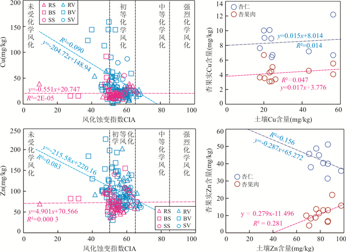

2021, 46(7): 2646-2656.
doi: 10.3799/dqkx.2020.249
Abstract:
In Laoyulin geothermal system of Kangding, we uses TOUGH-Isotope program to conduct the numerical simulation of water-heat-isotope coupling. In view of the obvious seasonality of stable isotopes in precipitation and active seismic activity in the research area, the impact that the isotope characteristics of recharge water and thermal reservoir permeability variation on the transport of hydrogen and oxygen isotopes in the geothermal system also are explored in this paper. The results indicate that the calculate values of hydrogen and oxygen isotopes of the hot water are generally with the measured values in ZK3 borehole, and the convection-dispersion effect of the high-temperature geothermal system has a significant effect on the migration process of hydrogen and oxygen isotopes. The geothermal water circulation conditions in the study area are strong, which causes the phenomenon of oxygen isotope enrichment to be slight. In the geothermal water circulation, the two factors-isotope characteristics of recharge water and thermal reservoir permeability have significant effects on the distribution of hydrogen and oxygen isotopes. Therefore, the numerical modelling of stable isotope transport processes in the geothermal system fluid can help to improve the quantitative understanding of the dynamic evolution of the geothermal system, which will provide support for geothermal development.
In Laoyulin geothermal system of Kangding, we uses TOUGH-Isotope program to conduct the numerical simulation of water-heat-isotope coupling. In view of the obvious seasonality of stable isotopes in precipitation and active seismic activity in the research area, the impact that the isotope characteristics of recharge water and thermal reservoir permeability variation on the transport of hydrogen and oxygen isotopes in the geothermal system also are explored in this paper. The results indicate that the calculate values of hydrogen and oxygen isotopes of the hot water are generally with the measured values in ZK3 borehole, and the convection-dispersion effect of the high-temperature geothermal system has a significant effect on the migration process of hydrogen and oxygen isotopes. The geothermal water circulation conditions in the study area are strong, which causes the phenomenon of oxygen isotope enrichment to be slight. In the geothermal water circulation, the two factors-isotope characteristics of recharge water and thermal reservoir permeability have significant effects on the distribution of hydrogen and oxygen isotopes. Therefore, the numerical modelling of stable isotope transport processes in the geothermal system fluid can help to improve the quantitative understanding of the dynamic evolution of the geothermal system, which will provide support for geothermal development.


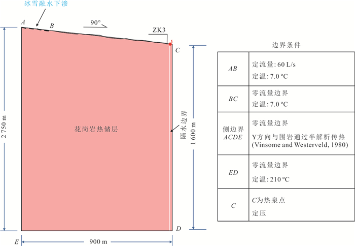

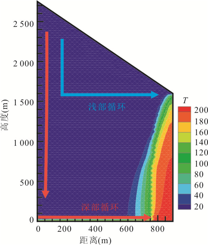


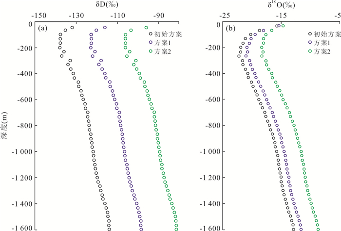


2021, 46(7): 2657-2674.
doi: 10.3799/dqkx.2020.243
Abstract:
In order to analyse the characteristic of seismogenic structure and tectonic stress field about Palu earthquake. Based on the focal mechanism solution from Global CMT catalog between January 1976 and April 2018, the tectonic stress field is inverted about Palu Indonesia earthquake on September 28th, 2018 and Sulawesi area. The conclusions are obtained as follows: Tectonic stress field are consistency and inhomogeneity in both sides of the boundary 0°. The compressive axis is plunging to north with lower plunge and extensional axis is plunging to south with larger plunge in North area. And South area is compressed in the direction of NNW-EW and extended in the direction of N-S with lower plunge. The tectonic stress field in northern area is a subduction zone, and the stress regime is difference in North Sula Block and Manado Block, because of pushing from Batui Thrust and blocking from Celebes Sea. In the south area, the crustal material is escaped in the direction of NNE-SSW, under compression in the direction of E-W, from Banda Sea and Makasa Basin. Lower R value in central Sulawesi is probably caused by mantle flow upwelling from upper mantle. The tectonic stress field and R value are complicated and heterogeneous in eastern area, which is effected by Sanghie double subduction, Minahassa Trench and active volcano. The tectonic stress field is strike slip regime with a little part of normal in western area, which is beneficial to trigger this earthquake and supershear.
In order to analyse the characteristic of seismogenic structure and tectonic stress field about Palu earthquake. Based on the focal mechanism solution from Global CMT catalog between January 1976 and April 2018, the tectonic stress field is inverted about Palu Indonesia earthquake on September 28th, 2018 and Sulawesi area. The conclusions are obtained as follows: Tectonic stress field are consistency and inhomogeneity in both sides of the boundary 0°. The compressive axis is plunging to north with lower plunge and extensional axis is plunging to south with larger plunge in North area. And South area is compressed in the direction of NNW-EW and extended in the direction of N-S with lower plunge. The tectonic stress field in northern area is a subduction zone, and the stress regime is difference in North Sula Block and Manado Block, because of pushing from Batui Thrust and blocking from Celebes Sea. In the south area, the crustal material is escaped in the direction of NNE-SSW, under compression in the direction of E-W, from Banda Sea and Makasa Basin. Lower R value in central Sulawesi is probably caused by mantle flow upwelling from upper mantle. The tectonic stress field and R value are complicated and heterogeneous in eastern area, which is effected by Sanghie double subduction, Minahassa Trench and active volcano. The tectonic stress field is strike slip regime with a little part of normal in western area, which is beneficial to trigger this earthquake and supershear.