2021 Vol. 46, No. 8
Display Method:
 PDF 1065KB
2021, 46(8): 2675-2696.
doi: 10.3799/dqkx.2020.304
Abstract:
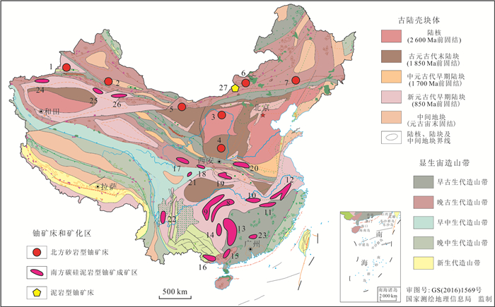
In the past 20 years,a series of large and super-large sandstone type uranium deposits have been discovered in six sedimentary basins in the northern China. The abundant uranium resources indicate that the sedimentary basin is a huge chemical reactor for uranium concentration. However,the types of uranium deposits in the basin are far more than sandstone type,which together constitute valuable uranium resources in the basin. In the course of development and evolution of sedimentary basins,a series of uranium deposits restricted by sedimentation,diagenesis and tectonism are collectively referred to as basin uranium resources. Fully considering the key constraints of uranium mineralization and the development sequence of deposit formation,the uranium resources in the basin can be divided into three categories,i.e.,synsedimentary type,unconformity type and diagenetic type,and 13 subtypes. Driven by the tectonic system of basin mountain coupling,the variable valence property of uranium is the basis of large-scale uranium cycle (convergence and dispersion),which makes various uranium deposits have genetic connection and mutual transformation. The genetic type,spatial and temporal distribution and resource scale of uranium resources in proven basins in China are extremely unbalanced. However,uranium resources in the basin show the basic pattern of "one north and one south","one land and one sea" and "one new and one old",with sandstone type uranium deposits dominating in the north and carbonaceous siliceous mudstone type uranium deposits dominating in the south. At present,sandstone type uranium deposits in northern China are the focus of exploration and development in China. However,the heterogeneity of uranium reservoir structure and material composition requires that in-situ leaching uranium mining technology needs to be innovated to suit the development of most sandstone type uranium deposits. At the same time,it needs to find more new types of uranium deposits in new areas and new horizons,and needs to rely on technological research and development to activate the discovered series dead mines of "ultra-low porosity and ultra-low permeability","rich organic matter" and "deep buried depth" represented by the southern carbonaceous siliceous mudstone type uranium deposits.
In the past 20 years,a series of large and super-large sandstone type uranium deposits have been discovered in six sedimentary basins in the northern China. The abundant uranium resources indicate that the sedimentary basin is a huge chemical reactor for uranium concentration. However,the types of uranium deposits in the basin are far more than sandstone type,which together constitute valuable uranium resources in the basin. In the course of development and evolution of sedimentary basins,a series of uranium deposits restricted by sedimentation,diagenesis and tectonism are collectively referred to as basin uranium resources. Fully considering the key constraints of uranium mineralization and the development sequence of deposit formation,the uranium resources in the basin can be divided into three categories,i.e.,synsedimentary type,unconformity type and diagenetic type,and 13 subtypes. Driven by the tectonic system of basin mountain coupling,the variable valence property of uranium is the basis of large-scale uranium cycle (convergence and dispersion),which makes various uranium deposits have genetic connection and mutual transformation. The genetic type,spatial and temporal distribution and resource scale of uranium resources in proven basins in China are extremely unbalanced. However,uranium resources in the basin show the basic pattern of "one north and one south","one land and one sea" and "one new and one old",with sandstone type uranium deposits dominating in the north and carbonaceous siliceous mudstone type uranium deposits dominating in the south. At present,sandstone type uranium deposits in northern China are the focus of exploration and development in China. However,the heterogeneity of uranium reservoir structure and material composition requires that in-situ leaching uranium mining technology needs to be innovated to suit the development of most sandstone type uranium deposits. At the same time,it needs to find more new types of uranium deposits in new areas and new horizons,and needs to rely on technological research and development to activate the discovered series dead mines of "ultra-low porosity and ultra-low permeability","rich organic matter" and "deep buried depth" represented by the southern carbonaceous siliceous mudstone type uranium deposits.


2021, 46(8): 2697-2710.
doi: 10.3799/dqkx.2020.295
Abstract:
The Permian karst bauxites in western Guangxi are the source material of the Quaternary Salento bauxites,but their specific mineralization process is still unclear. Based on the 1:50 000 regional geological survey,this paper reveals concrete mineralization process of Permian bauxite from source rock weathering to transport deposition in western Guangxi by focusing on basic sequence of bauxitic series in Heshan Formation,source materials of bauxitic ore,paleokarst control of bauxite mineralization and generation sequence of aluminous minerals of the Permian bauxite deposits and occurrences. Integrating previous studies,it is proposed that geological process of Permian karst bauxite in western Guangxi includes four mineralization stages,namely uplifting of isolated platform and receiving volcanic materials,in-situ deep weathering,waterlogging gleization and buried mineralization.
The Permian karst bauxites in western Guangxi are the source material of the Quaternary Salento bauxites,but their specific mineralization process is still unclear. Based on the 1:50 000 regional geological survey,this paper reveals concrete mineralization process of Permian bauxite from source rock weathering to transport deposition in western Guangxi by focusing on basic sequence of bauxitic series in Heshan Formation,source materials of bauxitic ore,paleokarst control of bauxite mineralization and generation sequence of aluminous minerals of the Permian bauxite deposits and occurrences. Integrating previous studies,it is proposed that geological process of Permian karst bauxite in western Guangxi includes four mineralization stages,namely uplifting of isolated platform and receiving volcanic materials,in-situ deep weathering,waterlogging gleization and buried mineralization.


2021, 46(8): 2711-2731.
doi: 10.3799/dqkx.2020.301
Abstract:
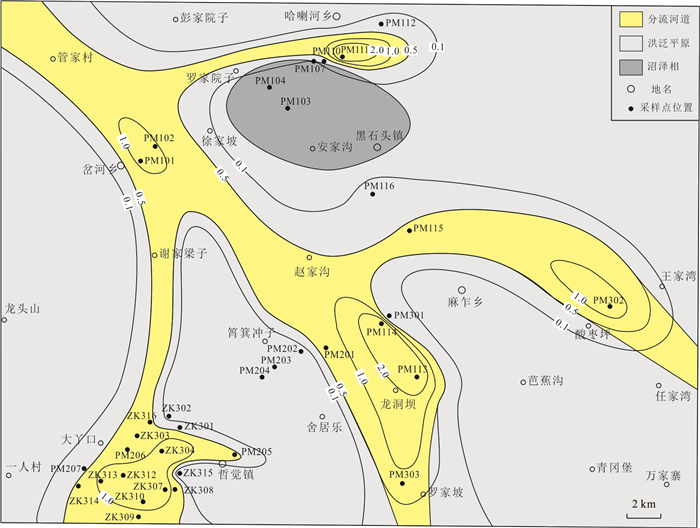
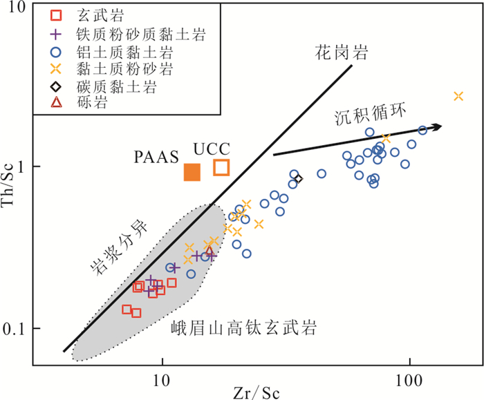
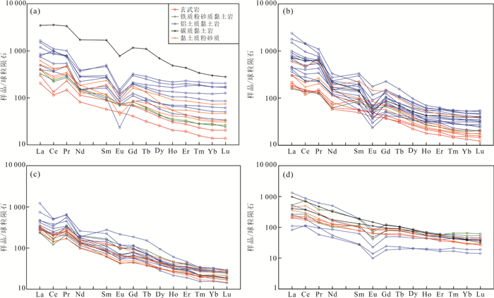
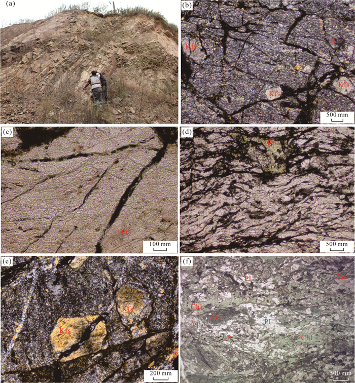
The genetic types of the rare earth ore-bearing rocks at the bottom of Xuanwei Formation in Weining area,Guizhou Province are controversial. In order to clarify the genetic mechanism and concentration regularity,through field investigation combined with mineralogy,lithofacies paleogeographic features and geochemistry,systematic research has been carried out. The results show that the rare earth ore-bearing rocks at the bottom of the Xuanwei Formation of Permian are widely distributed with good continuity and the thickness of ore-bearing sections varies from 2 to 16 m,and associated with niobium,zirconium,gallium and other elements. The average grade of rare earth oxide element is 0.15%,and the highest grade is up to 1.6%. The analyses of major,trace and rare earth elements shows that the rare earth ore-bearing rocks in Weining area contain typical minerals from basalt and volcanic ash,the rare earth element distribution patterns are inherited from basalt. The chemical weathering in the study area is stronger,and the higher maturity of the ingredients means that it has been transformed after being transported for a long distance. The Emeishan basalt provides the main material source for the rare earth layer. The rare earth layer is controlled by the composition of the source rock,has undergone sedimentary separation and recycling,and has suffered from the mixing of intermediate-acid magmatic material source region from the upper crust.The genetic mechanism is suggested as that the basalt was weathered and denuded in the hot,humid and strongly weathered environment during the Late Permian,after weathering and denudation,the basalt was transported to the flood plain microfacies in the delta plain subfacies between the volcanic depressions,and deposited with the volcanic ash. Under weathering and leaching,the rare earth elements were resolved as ions,and then they were adsorbed on the surface of clay minerals such as kaolinite with strong adsorption ability,or entered into the crystal lattice to form the rare-earth rich layer.
The genetic types of the rare earth ore-bearing rocks at the bottom of Xuanwei Formation in Weining area,Guizhou Province are controversial. In order to clarify the genetic mechanism and concentration regularity,through field investigation combined with mineralogy,lithofacies paleogeographic features and geochemistry,systematic research has been carried out. The results show that the rare earth ore-bearing rocks at the bottom of the Xuanwei Formation of Permian are widely distributed with good continuity and the thickness of ore-bearing sections varies from 2 to 16 m,and associated with niobium,zirconium,gallium and other elements. The average grade of rare earth oxide element is 0.15%,and the highest grade is up to 1.6%. The analyses of major,trace and rare earth elements shows that the rare earth ore-bearing rocks in Weining area contain typical minerals from basalt and volcanic ash,the rare earth element distribution patterns are inherited from basalt. The chemical weathering in the study area is stronger,and the higher maturity of the ingredients means that it has been transformed after being transported for a long distance. The Emeishan basalt provides the main material source for the rare earth layer. The rare earth layer is controlled by the composition of the source rock,has undergone sedimentary separation and recycling,and has suffered from the mixing of intermediate-acid magmatic material source region from the upper crust.The genetic mechanism is suggested as that the basalt was weathered and denuded in the hot,humid and strongly weathered environment during the Late Permian,after weathering and denudation,the basalt was transported to the flood plain microfacies in the delta plain subfacies between the volcanic depressions,and deposited with the volcanic ash. Under weathering and leaching,the rare earth elements were resolved as ions,and then they were adsorbed on the surface of clay minerals such as kaolinite with strong adsorption ability,or entered into the crystal lattice to form the rare-earth rich layer.


2021, 46(8): 2732-2750.
doi: 10.3799/dqkx.2020.322
Abstract:
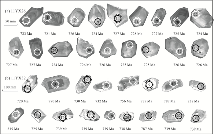
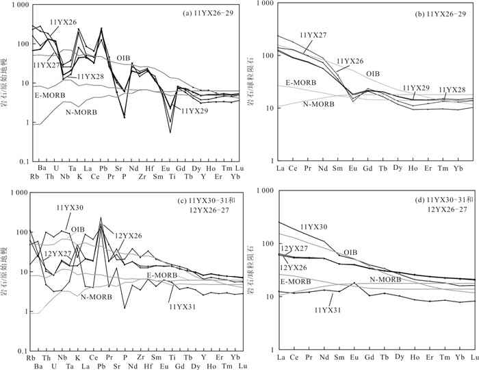
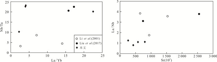
In order to understand the tectonic properties of the northern margin of Dabie belt,the stratum,age and geochemical characteristics of Dingyuan Formation were investigated and studied. Field survey shows that the Dingyuan Formation is composed of a set of metavolcanic rocks,mica schist,mica quartz schist,leptite and slate,etc.. The metavolcanics are mainly metabasalts and meta-rhyolitic volcanics which constitute typical bimodal volcanic formation. In addition,it contains Early Paleozoic tectono-stratigraphic unit. The LA-ICP-MS U-Pb dating of zircon from acidic volcanic rocks yields the ages of 725.7±1.4 Ma and 736.6±5.4 Ma,indicating the Neoproterozoic rather than the Early Paleozoic ages. The metabasalts are divided into two types: low Ti(TiO2=1.19%) and high Ti(TiO2=3.11% on average). The total amount of rare earth elements of low Ti basalts is lower than N-MORB type and the magma came from the depleted mantle source area. The high Ti basalt can be further divided into two types. One type is rich in Nb and Ta,and the ratio of incompatible elements is close to that of continental rift basalt. The other type of loss-Nb,Ta,Th,U and other elements,the magma probably came from the modified mantle by the lower crust or altered oceanic crust. Its Th/Ta is 1.6,which is close to the Th/Ta ratio of the continental rift basalt. In a word,the geochemical characteristics of the metamorphic basalts are very different,which reflects the heterogeneity of the source area of the mantle. Large ionic lithophile elements Rb,Ba,Th,U and K are enriched in acidic volcanic rocks,depletion Nb,Ta,P,Ti and other elements,the value of εHf(t) is -3.0 to -10 by zircon Hf isotope analysis,two-stage Hf mode age (TDM2(Hf)) is 1 630-2 258 Ma,it reveals that it came from a partial melting of the ancient crust. The Neoproterozoic bimodal volcanic rocks of the Dingyuan Formation was formed in the continental rift environment,not in the background of island arc structure. The bimodal volcanic rocks and the widely distributed contemporaneous magmatic rocks reveal an important continental margin rifting-magma event in the northern margin of the Yangtze Block during the Neoproterozoic period (800-611 Ma),which is ground surface response of the deep dynamics to the breakup of supercontinent Rodinia.
In order to understand the tectonic properties of the northern margin of Dabie belt,the stratum,age and geochemical characteristics of Dingyuan Formation were investigated and studied. Field survey shows that the Dingyuan Formation is composed of a set of metavolcanic rocks,mica schist,mica quartz schist,leptite and slate,etc.. The metavolcanics are mainly metabasalts and meta-rhyolitic volcanics which constitute typical bimodal volcanic formation. In addition,it contains Early Paleozoic tectono-stratigraphic unit. The LA-ICP-MS U-Pb dating of zircon from acidic volcanic rocks yields the ages of 725.7±1.4 Ma and 736.6±5.4 Ma,indicating the Neoproterozoic rather than the Early Paleozoic ages. The metabasalts are divided into two types: low Ti(TiO2=1.19%) and high Ti(TiO2=3.11% on average). The total amount of rare earth elements of low Ti basalts is lower than N-MORB type and the magma came from the depleted mantle source area. The high Ti basalt can be further divided into two types. One type is rich in Nb and Ta,and the ratio of incompatible elements is close to that of continental rift basalt. The other type of loss-Nb,Ta,Th,U and other elements,the magma probably came from the modified mantle by the lower crust or altered oceanic crust. Its Th/Ta is 1.6,which is close to the Th/Ta ratio of the continental rift basalt. In a word,the geochemical characteristics of the metamorphic basalts are very different,which reflects the heterogeneity of the source area of the mantle. Large ionic lithophile elements Rb,Ba,Th,U and K are enriched in acidic volcanic rocks,depletion Nb,Ta,P,Ti and other elements,the value of εHf(t) is -3.0 to -10 by zircon Hf isotope analysis,two-stage Hf mode age (TDM2(Hf)) is 1 630-2 258 Ma,it reveals that it came from a partial melting of the ancient crust. The Neoproterozoic bimodal volcanic rocks of the Dingyuan Formation was formed in the continental rift environment,not in the background of island arc structure. The bimodal volcanic rocks and the widely distributed contemporaneous magmatic rocks reveal an important continental margin rifting-magma event in the northern margin of the Yangtze Block during the Neoproterozoic period (800-611 Ma),which is ground surface response of the deep dynamics to the breakup of supercontinent Rodinia.


2021, 46(8): 2751-2767.
doi: 10.3799/dqkx.2020.266
Abstract:
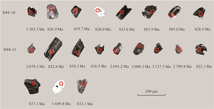
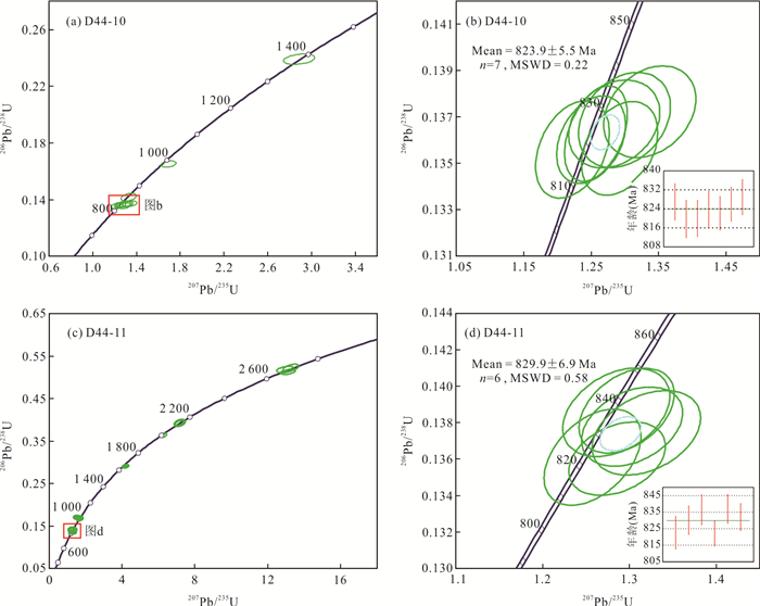
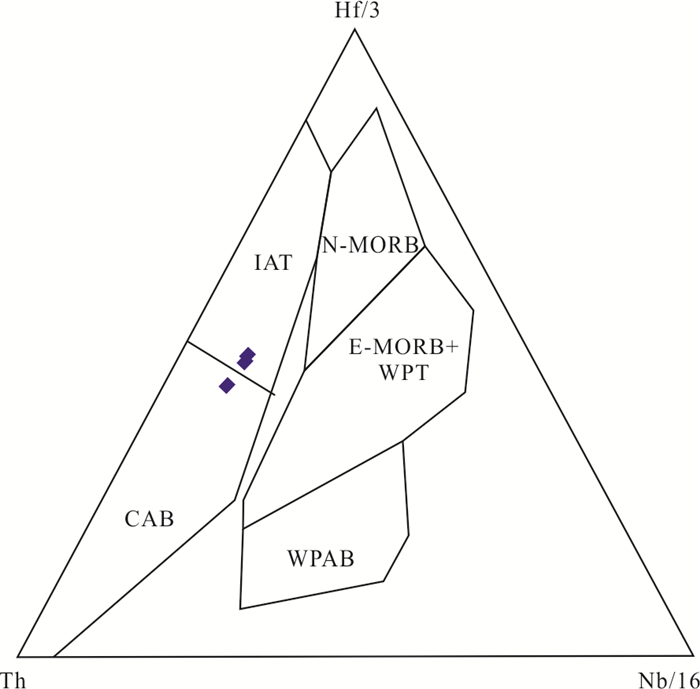
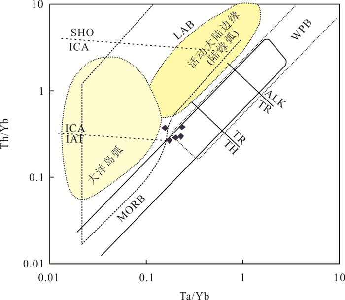
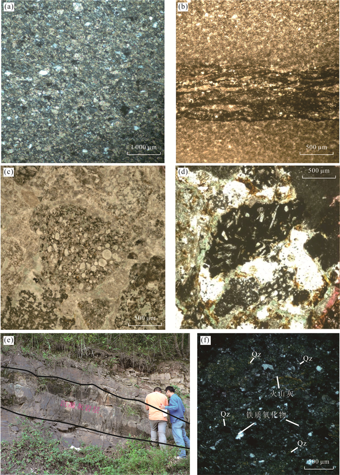
The Huashan Group,which was once regarded as the eastward extension part of the Paleozoic "Mianlüe ophiolite" or the Neoproterozoic subduction-accretion-complex,has been controversial so far. To identify its tectonic significance and its relationship with the Rodinia supercontinet,the petrogenesis and age of the Liufangzui Formation by clastic tracing,redox index,tectonic discrimination and zircon U-Pb dating were studied. The sedimentary basin of the Liufangzui Formation is a marginal sea with oxidation condition,in which the clastic rocks had two sources,including sand debris from the Yangtze Block and basaltic glass debris,suggesting that the strata and the basalt were associated products in the same period,but not emplacements in a melange. The basalts which have dual-characteristics between MORB and IAB,are actually BABB. 823.9±5.5 Ma and 829.9±6.9 Ma of zircon ages were obtained,as well as 1 637 Ma and 2 670 Ma of xenocrystal zircon ages from these basalts,which implies that there was probably an continental basement in the lower part of the volcanic channel,but not a mid-ocean-ridge. The Liufangzui Formation of the Huashan Group is a Neoproterozoic back-arc-basin sedimentary-volcanic strata rather than an ophiolitic mélange. In Late Neoproterozoic,a plate-subduction movement took place in the northern margin of Yangtze Block,which lagged behind the global Rodinia supercontinent breakup event.
The Huashan Group,which was once regarded as the eastward extension part of the Paleozoic "Mianlüe ophiolite" or the Neoproterozoic subduction-accretion-complex,has been controversial so far. To identify its tectonic significance and its relationship with the Rodinia supercontinet,the petrogenesis and age of the Liufangzui Formation by clastic tracing,redox index,tectonic discrimination and zircon U-Pb dating were studied. The sedimentary basin of the Liufangzui Formation is a marginal sea with oxidation condition,in which the clastic rocks had two sources,including sand debris from the Yangtze Block and basaltic glass debris,suggesting that the strata and the basalt were associated products in the same period,but not emplacements in a melange. The basalts which have dual-characteristics between MORB and IAB,are actually BABB. 823.9±5.5 Ma and 829.9±6.9 Ma of zircon ages were obtained,as well as 1 637 Ma and 2 670 Ma of xenocrystal zircon ages from these basalts,which implies that there was probably an continental basement in the lower part of the volcanic channel,but not a mid-ocean-ridge. The Liufangzui Formation of the Huashan Group is a Neoproterozoic back-arc-basin sedimentary-volcanic strata rather than an ophiolitic mélange. In Late Neoproterozoic,a plate-subduction movement took place in the northern margin of Yangtze Block,which lagged behind the global Rodinia supercontinent breakup event.


2021, 46(8): 2768-2785.
doi: 10.3799/dqkx.2020.319
Abstract:
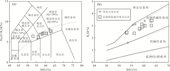
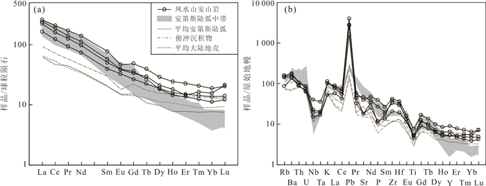
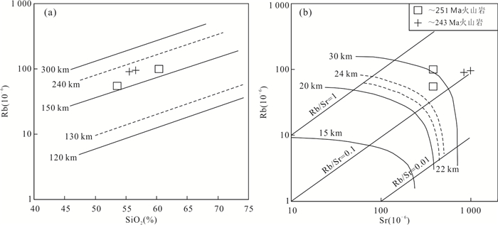
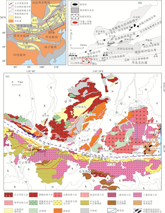
The andesite is closely related to the subduction tectonic environment,and the study of andesite can obtain important information about the age of subduction and related subduction processes. In this paper it presents petrographic characteristics,whole-rock geochemical data and zircon U-Pb ages of the Early to Middle Triassic andesites from the Fengshui Mountain area in the Erguna massif in the northern Great Xing'an Range for the purpose of revealing the initial southward subduction of the Mongol-Okhotsk oceanic plate. Most of the zircons from the andesite in the Fengshui Mountain area are euhedral to subhedral in shape,with typical oscillating growth zonation and relatively high Th/U ratios (0.23-1.34),indicative of magmatic zircons. Zircon LA-ICP-MS U-Pb dating yields two ages of 251±2 Ma and 243±2 Ma for andesite in the Fengshui Mountain area,indicative of Early and Middle Triassic ages for the andesites. These Early Mesozoic andesites have typical geochemical characteristics of active continental margin arc magmatite with SiO2,Al2O3,K2O,Na2O,Fe2O3T,MgO,TiO2 and total alkali (K2O+Na2O) contents ranging from 53.52% to 60.38%,16.17% to 17.41%,1.60% to 4.60%,3.83% to 4.65%,5.55% to 8.93%,1.96% to 5.97%,0.97% to 1.67%,and 5.60% to 8.05%,respectively. These andesites are high K calc-alkaline with Na2O/K2O ratios ranging from 1.23 to 2.51,A/CNK values (aluminum saturation index) from 0.86 to 0.97 and Mg# values ranging from 47 to 75. These volcanic rocks are enriched in large ionic lithophile elements such as Rb,Ba,U,K,Pb and light rare earth elements,but depleted in high field strength elements such as Nb,Ta,Ti,P and heavy rare earth elements,with weak negative Eu anomaly (δEu=0.74-0.99). These Early Mesozoic andesitic rocks are geochemically similar to the typical andesites in Andean,thus indicating that they are most likely formed in the Andean-type active continental margin environment related to the southward subduction of the Mongol-Okhotsk oceanic plate.
The andesite is closely related to the subduction tectonic environment,and the study of andesite can obtain important information about the age of subduction and related subduction processes. In this paper it presents petrographic characteristics,whole-rock geochemical data and zircon U-Pb ages of the Early to Middle Triassic andesites from the Fengshui Mountain area in the Erguna massif in the northern Great Xing'an Range for the purpose of revealing the initial southward subduction of the Mongol-Okhotsk oceanic plate. Most of the zircons from the andesite in the Fengshui Mountain area are euhedral to subhedral in shape,with typical oscillating growth zonation and relatively high Th/U ratios (0.23-1.34),indicative of magmatic zircons. Zircon LA-ICP-MS U-Pb dating yields two ages of 251±2 Ma and 243±2 Ma for andesite in the Fengshui Mountain area,indicative of Early and Middle Triassic ages for the andesites. These Early Mesozoic andesites have typical geochemical characteristics of active continental margin arc magmatite with SiO2,Al2O3,K2O,Na2O,Fe2O3T,MgO,TiO2 and total alkali (K2O+Na2O) contents ranging from 53.52% to 60.38%,16.17% to 17.41%,1.60% to 4.60%,3.83% to 4.65%,5.55% to 8.93%,1.96% to 5.97%,0.97% to 1.67%,and 5.60% to 8.05%,respectively. These andesites are high K calc-alkaline with Na2O/K2O ratios ranging from 1.23 to 2.51,A/CNK values (aluminum saturation index) from 0.86 to 0.97 and Mg# values ranging from 47 to 75. These volcanic rocks are enriched in large ionic lithophile elements such as Rb,Ba,U,K,Pb and light rare earth elements,but depleted in high field strength elements such as Nb,Ta,Ti,P and heavy rare earth elements,with weak negative Eu anomaly (δEu=0.74-0.99). These Early Mesozoic andesitic rocks are geochemically similar to the typical andesites in Andean,thus indicating that they are most likely formed in the Andean-type active continental margin environment related to the southward subduction of the Mongol-Okhotsk oceanic plate.


2021, 46(8): 2786-2803.
doi: 10.3799/dqkx.2020.281
Abstract:
There has been a lack of direct evidence for the existence of continental crust in the Early Paleozoic accretion zone on the southern margin of Xing-Meng Orogenic Belt (XMOB),which restricts the understanding on the structure and evolution of the orogen. This study identified Late Mesoproterozoic metamorphic strata in the Chegendalai area,Northeast Damaoqi,which belongs to the southern margin of XMOB. Field investigation,zircon geochronology and Hf isotopic geochemistry indicate that this set of strata represents the continental crust in the accretion zone. The detrital zircon ages of the strata are mainly concentrated at~1.8 Ga,and with minor peaks such as~3.0 Ga,~2.8 Ga,~2.5 Ga,and~1.6 Ga. This age distribution is consistent with the Bayan Obo Group,Huade Group and Langshan Group in the north margin of North China,implying the continental crust in accretion zone should be part of the North China Block,and its material provenance is also mainly from the northern margin of North China Craton. The identification of the Mesoproterozoic strata and its affinity with North China Block indicate that the southern margin of XMOB belongs to active continental margin in Early Paleozoic. In addition,the relationship between the strata and Chegendalai tectonic belts shows that the latter is not an ophiolite,but is more likely to be generated by the intrusion of ultrabasic rocks resulted from back-arc extension.
There has been a lack of direct evidence for the existence of continental crust in the Early Paleozoic accretion zone on the southern margin of Xing-Meng Orogenic Belt (XMOB),which restricts the understanding on the structure and evolution of the orogen. This study identified Late Mesoproterozoic metamorphic strata in the Chegendalai area,Northeast Damaoqi,which belongs to the southern margin of XMOB. Field investigation,zircon geochronology and Hf isotopic geochemistry indicate that this set of strata represents the continental crust in the accretion zone. The detrital zircon ages of the strata are mainly concentrated at~1.8 Ga,and with minor peaks such as~3.0 Ga,~2.8 Ga,~2.5 Ga,and~1.6 Ga. This age distribution is consistent with the Bayan Obo Group,Huade Group and Langshan Group in the north margin of North China,implying the continental crust in accretion zone should be part of the North China Block,and its material provenance is also mainly from the northern margin of North China Craton. The identification of the Mesoproterozoic strata and its affinity with North China Block indicate that the southern margin of XMOB belongs to active continental margin in Early Paleozoic. In addition,the relationship between the strata and Chegendalai tectonic belts shows that the latter is not an ophiolite,but is more likely to be generated by the intrusion of ultrabasic rocks resulted from back-arc extension.


2021, 46(8): 2804-2818.
doi: 10.3799/dqkx.2020.279
Abstract:
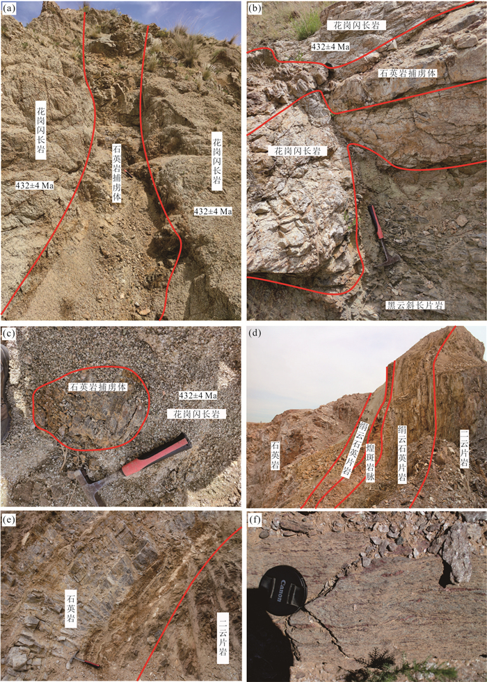
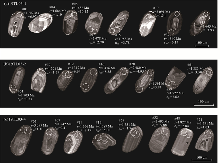
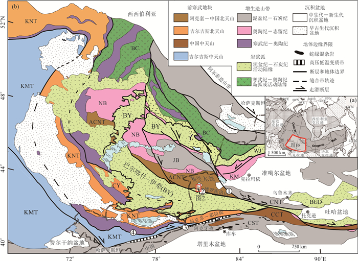
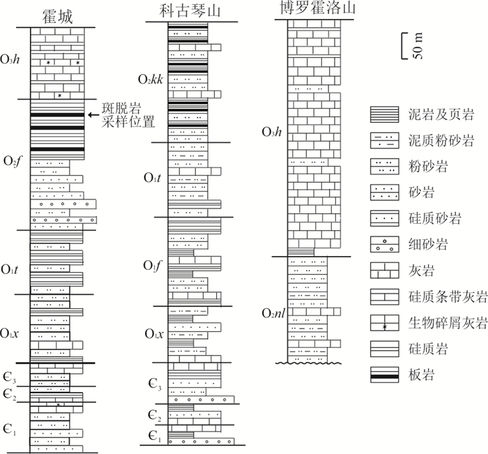
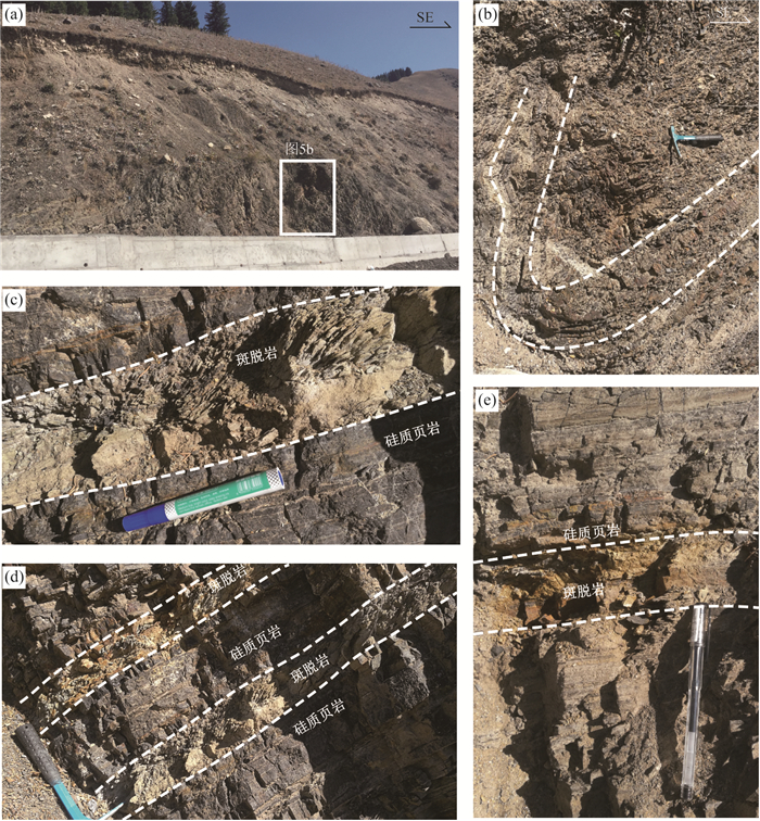
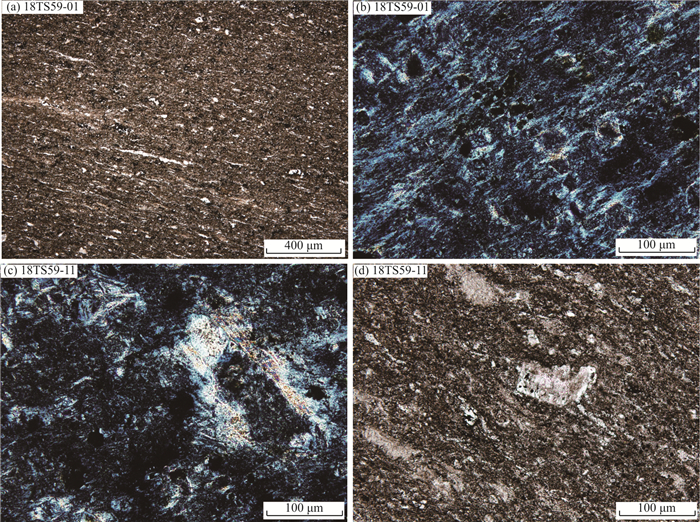
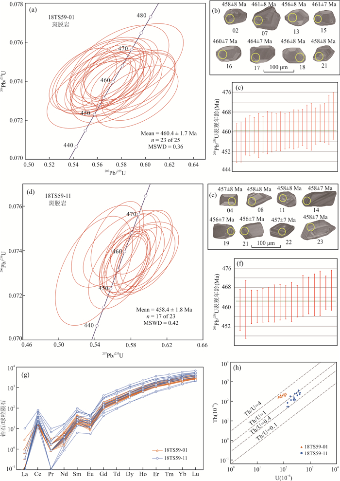
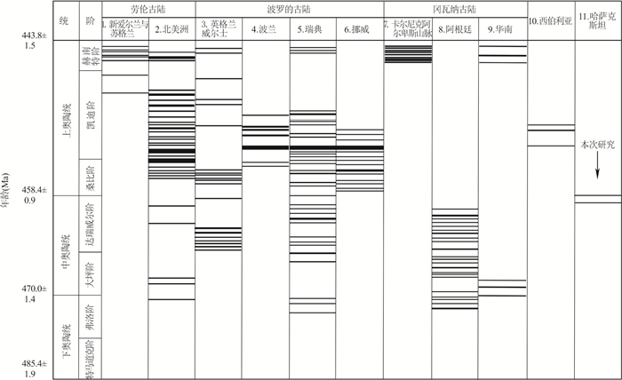
The Yili Block,a part of the Central Asian Orogenic Belt (CAOB),is located in the northern part of Chinese western Tianshan. It is generally believed that the northern Yili Block was an active continental margin during the Late Paleozoic. However,the study of sedimentary and tectonic evolution (especially the isotopic dating) of the Early Paleozoic in the northern Yili Block is relatively weak. Several bentonite (altered tuff) horizons within the Ordovician black siliceous shale sequences in the Guozigou area were recognized. The Ordovician strata were intensively folded. Two bentonite samples were collected from the core and limb of a syncline for zircon U-Pb dating. Both samples indicate their magmatic origin. They yielded consistent and concordant apparent ages,and weighted average ages of 458±2 Ma and 460±2 Ma,respectively. The previous and newly obtained data implies that the bentonites were deposited at the end of Middle Ordovician (Darriwilian Stage). The timing of the bentonites in this study is in agreement with the age of the continental arc-type magmatism in the Wenquan area,both were likely derived from subduction of the Junggar Ocean beneath the northern Yili Block. The bentonites are also coeval with the worldwide intense volcanism,and are likely one of the main causes of the Late Ordovician global climate change and mass extinction.
The Yili Block,a part of the Central Asian Orogenic Belt (CAOB),is located in the northern part of Chinese western Tianshan. It is generally believed that the northern Yili Block was an active continental margin during the Late Paleozoic. However,the study of sedimentary and tectonic evolution (especially the isotopic dating) of the Early Paleozoic in the northern Yili Block is relatively weak. Several bentonite (altered tuff) horizons within the Ordovician black siliceous shale sequences in the Guozigou area were recognized. The Ordovician strata were intensively folded. Two bentonite samples were collected from the core and limb of a syncline for zircon U-Pb dating. Both samples indicate their magmatic origin. They yielded consistent and concordant apparent ages,and weighted average ages of 458±2 Ma and 460±2 Ma,respectively. The previous and newly obtained data implies that the bentonites were deposited at the end of Middle Ordovician (Darriwilian Stage). The timing of the bentonites in this study is in agreement with the age of the continental arc-type magmatism in the Wenquan area,both were likely derived from subduction of the Junggar Ocean beneath the northern Yili Block. The bentonites are also coeval with the worldwide intense volcanism,and are likely one of the main causes of the Late Ordovician global climate change and mass extinction.


2021, 46(8): 2819-2831.
doi: 10.3799/dqkx.2020.197
Abstract:
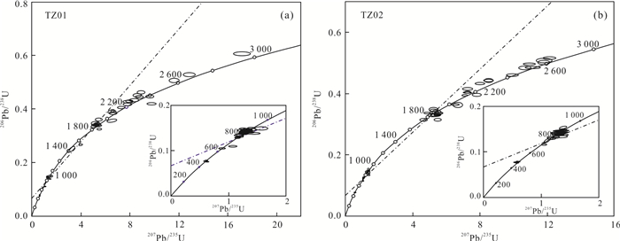
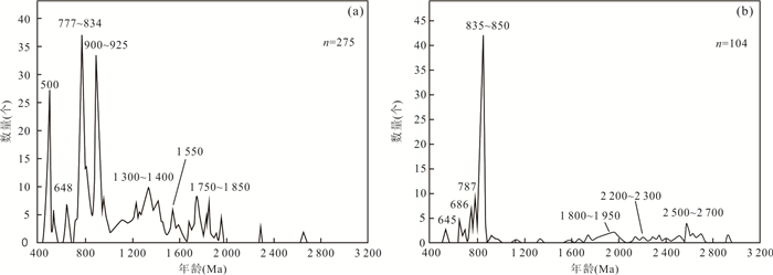
There is still uncertainty in the understanding of the source of the Silurian sedimentation in Tazhong area of Tarim Basin. Using LA-ICP-MS analysis technology,two samples of the Kepingtage Formation in Tazhong area were collected for detrital zircon U-Pb chronology. The results show that the zircons are mainly of magmatic crystallization origin and their ages are mainly distributed in four periods: Early Paleozoic 460-490 Ma,Neoproterozoic 760-1 000 Ma,Paleoproterozoic 1 600-2 200 Ma,and Late Neoarchaean-Early Paleoproterozoic 2 400-2 600 Ma. The Neoproterozoic 760-1 000 Ma detrital zircon ages take the largest proportion (56.8%),with a~850 Ma single peak. Based on the plate dynamics background of the northern and southern margins of the Tarim plate during the Silurian Period,the analysis of tectonic evolution and geomorphologic features within the basin,as well as the detailed comparison of zircon ages with the potential provenance area,it is proposed that the Tazhong Silurian detrital zircons were mainly sourced from the Tiekelike uplift in the southwest margin of Tarim Basin.
There is still uncertainty in the understanding of the source of the Silurian sedimentation in Tazhong area of Tarim Basin. Using LA-ICP-MS analysis technology,two samples of the Kepingtage Formation in Tazhong area were collected for detrital zircon U-Pb chronology. The results show that the zircons are mainly of magmatic crystallization origin and their ages are mainly distributed in four periods: Early Paleozoic 460-490 Ma,Neoproterozoic 760-1 000 Ma,Paleoproterozoic 1 600-2 200 Ma,and Late Neoarchaean-Early Paleoproterozoic 2 400-2 600 Ma. The Neoproterozoic 760-1 000 Ma detrital zircon ages take the largest proportion (56.8%),with a~850 Ma single peak. Based on the plate dynamics background of the northern and southern margins of the Tarim plate during the Silurian Period,the analysis of tectonic evolution and geomorphologic features within the basin,as well as the detailed comparison of zircon ages with the potential provenance area,it is proposed that the Tazhong Silurian detrital zircons were mainly sourced from the Tiekelike uplift in the southwest margin of Tarim Basin.


2021, 46(8): 2832-2849.
doi: 10.3799/dqkx.2020.278
Abstract:
There are still many controversies about the tectonic evolution time and subduction direction of the Bangong Co-Nujiang suture zone. Many Early Cretaceous magmatic rocks lie in the north margin of the central Lhasa Block, it is helpful to understand the setting of magma activity and tectonic dynamics by researching the genesis and formation mechanism of the magma in the Cretaceous period of the Lhasa Block. Based on detailed field investigation upon the Qusang'gele granite, a comprehensive research of their petrography, geochemistry, zircon U-Pb geochronology and Sr-Nd-Pb-Hf isotope was carried out. Qusang'gele granite has high contents of SiO2 (75.23%-77.66%), total (K2O+Na2O) (8.41%-8.94%), lower contents of A12O3 (11.96%-12.38%) and CaO (0.18%-0.55%), with Reitman index of 2.05-2.33, and A/CNK values of 0.99 to 1.03; it is enriched in LILE such as Rb, Th, U, K, Pb, and depleted in HFSE such as Nb, Ta, P, Ti; all samples are enriched in LREE and depleted in HREE, the LREE/HREE ratios is 2.42 to 5.00, with typical seagull-shaped distribution pattern, strong negative Eu anomalies of 0.048 to 0.075, without obvious negative Ce anomalies (δCe=0.739-1.471).Caculated zircon saturated temperatures of Qusang'gele granite range from 763.50 to 850.65℃, averaged at 795.2℃.Combined with the geochemical characteristics above, the Qusang'gele granite should be defined as A-type granite. The syenogranite has a weighted mean 206Pb/238U age of 101±1 Ma (MSWD=0.45) by LA-ICP-MS zircon U-Pb analysis, suggesting that the Qusang'gele magmatism took place during the Early Late Cretaceous. It has positive εHf(t) values of 4.44 to 5.85 and Hf model TDM1 ages of 536-592 Ma and TDM2 ages of 702-781 Ma; Qusang'gele granite is characterized with the (87Sr/86Sr)t values of 0.706 2 to 0.710 6, (143Nd/144Nd)t values of 0.512 315 to 0.512 441, and εNd(t) values of -6.27 to -3.82; (206Pb/204Pb)t values of 18.653 to 18.794, (207Pb/204Pb)t values of 15.709 to 15.731, and (208Pb/204Pb)t values of 38.960 to 39.100. It is showed that the partial melting of metamorphic mud in the upper crust during the post-collision stage between the Lhasa Block and the Qiangtang Block in the discrimination diagrams of tectonic setting. Therefore, the Qusang'gele granite occurred in post-collision extension stage when the deep Precambrian metamorphic basement underwent partially deep-melting due to the effect of thinning and decompression, which resulted in the A-type granite originated from the middle-upper crust of the thickened Lhasa Block.
There are still many controversies about the tectonic evolution time and subduction direction of the Bangong Co-Nujiang suture zone. Many Early Cretaceous magmatic rocks lie in the north margin of the central Lhasa Block, it is helpful to understand the setting of magma activity and tectonic dynamics by researching the genesis and formation mechanism of the magma in the Cretaceous period of the Lhasa Block. Based on detailed field investigation upon the Qusang'gele granite, a comprehensive research of their petrography, geochemistry, zircon U-Pb geochronology and Sr-Nd-Pb-Hf isotope was carried out. Qusang'gele granite has high contents of SiO2 (75.23%-77.66%), total (K2O+Na2O) (8.41%-8.94%), lower contents of A12O3 (11.96%-12.38%) and CaO (0.18%-0.55%), with Reitman index of 2.05-2.33, and A/CNK values of 0.99 to 1.03; it is enriched in LILE such as Rb, Th, U, K, Pb, and depleted in HFSE such as Nb, Ta, P, Ti; all samples are enriched in LREE and depleted in HREE, the LREE/HREE ratios is 2.42 to 5.00, with typical seagull-shaped distribution pattern, strong negative Eu anomalies of 0.048 to 0.075, without obvious negative Ce anomalies (δCe=0.739-1.471).Caculated zircon saturated temperatures of Qusang'gele granite range from 763.50 to 850.65℃, averaged at 795.2℃.Combined with the geochemical characteristics above, the Qusang'gele granite should be defined as A-type granite. The syenogranite has a weighted mean 206Pb/238U age of 101±1 Ma (MSWD=0.45) by LA-ICP-MS zircon U-Pb analysis, suggesting that the Qusang'gele magmatism took place during the Early Late Cretaceous. It has positive εHf(t) values of 4.44 to 5.85 and Hf model TDM1 ages of 536-592 Ma and TDM2 ages of 702-781 Ma; Qusang'gele granite is characterized with the (87Sr/86Sr)t values of 0.706 2 to 0.710 6, (143Nd/144Nd)t values of 0.512 315 to 0.512 441, and εNd(t) values of -6.27 to -3.82; (206Pb/204Pb)t values of 18.653 to 18.794, (207Pb/204Pb)t values of 15.709 to 15.731, and (208Pb/204Pb)t values of 38.960 to 39.100. It is showed that the partial melting of metamorphic mud in the upper crust during the post-collision stage between the Lhasa Block and the Qiangtang Block in the discrimination diagrams of tectonic setting. Therefore, the Qusang'gele granite occurred in post-collision extension stage when the deep Precambrian metamorphic basement underwent partially deep-melting due to the effect of thinning and decompression, which resulted in the A-type granite originated from the middle-upper crust of the thickened Lhasa Block.


2021, 46(8): 2850-2859.
doi: 10.3799/dqkx.2020.308
Abstract:
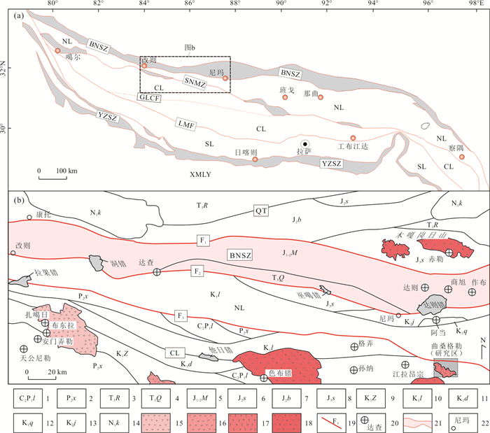
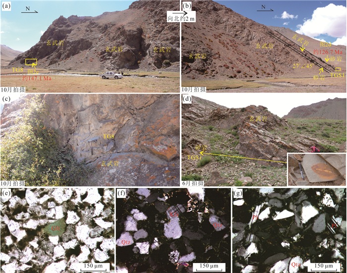
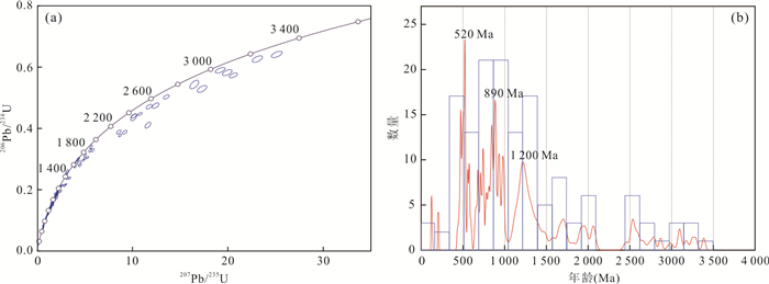
The eastern Tethyan Himalaya is located at the combination area of eastern Gondwana during the Mesozoic, and its paleogeography plays a vital role in understanding the breakup of eastern Gondwana. A detailed chronological study of detrital zircons was carried out on the sedimentary strata in Taga area. The zircon U-Pb isotope results show that the youngest age is 126.6±2.7 Ma, suggesting that the lower limit of sampling section was the Early Cretaceous. The U-Pb age spectra of detrital zircons reveal three major age peaks at~520 Ma, ~890 Ma, and~1 200 Ma, of which the comparison with those from adjacent areas indicates similar age populations with eastern India and southwestern Australia. New results, together with the surrounding magmatic activity and the age of basalts in the lower part of sampling section, support that the studied section should be developed during the separation of the eastern Tethyan Himalayan from eastern Gondwana, and the main provenance of the sampling section might be from eastern India, southwestern Australia, and Antarctic.
The eastern Tethyan Himalaya is located at the combination area of eastern Gondwana during the Mesozoic, and its paleogeography plays a vital role in understanding the breakup of eastern Gondwana. A detailed chronological study of detrital zircons was carried out on the sedimentary strata in Taga area. The zircon U-Pb isotope results show that the youngest age is 126.6±2.7 Ma, suggesting that the lower limit of sampling section was the Early Cretaceous. The U-Pb age spectra of detrital zircons reveal three major age peaks at~520 Ma, ~890 Ma, and~1 200 Ma, of which the comparison with those from adjacent areas indicates similar age populations with eastern India and southwestern Australia. New results, together with the surrounding magmatic activity and the age of basalts in the lower part of sampling section, support that the studied section should be developed during the separation of the eastern Tethyan Himalayan from eastern Gondwana, and the main provenance of the sampling section might be from eastern India, southwestern Australia, and Antarctic.


2021, 46(8): 2860-2872.
doi: 10.3799/dqkx.2020.288
Abstract:
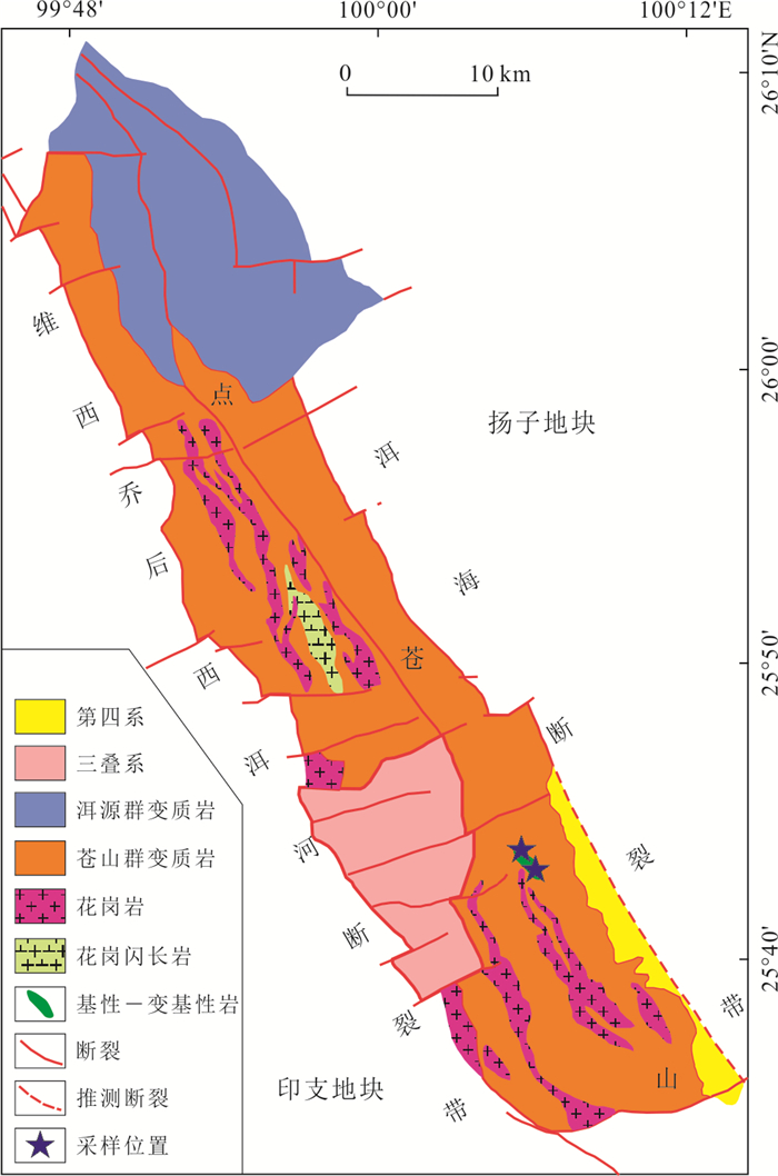
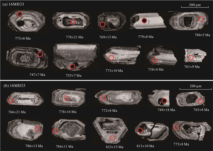
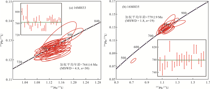
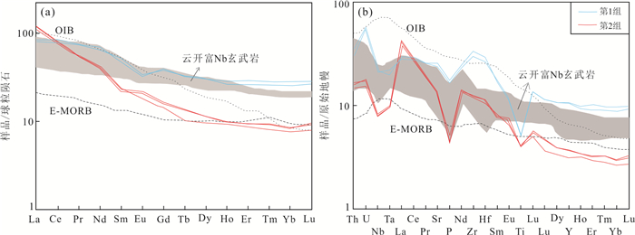
The current research on Neoproterozoic magmatism on the southwestern Yangtze Block is still weak, which restricts the complete understanding of the Neoproterozoic tectonic evolution of the South China Plate. Detailed zircon U-Pb geochronological and whole-rock geochemical analyses of amphibolite in the Diancangshan area in western Yunnan were carried out in this study. The amphibolite samples can be divided into two groups based on their Nb/La ratios. Group 1 has Nb/La ratios of 0.75-0.76, greater than 0.5, resembling those of Nb-enriched basalt, while Group 2 has Nb/La ratios of 0.20-0.21, and shows obvious negative Nb and Ta anomalies, and thus are similar to those of arc basalt. The group 1 samples have SiO2 contents of 52.4%-52.6%, MgO of 4.1%-4.2%, FeOt of 8.7%-8.8%, and Mg# of 53. The group 2 samples are characterized by lower SiO2 contents (47.4%-47.5%), and higher MgO (5.4%-5.5%), FeOt (9.8%-9.9%) contents, and Mg# (57). Both of the two group samples show slightly high degree of fractionation. The group 1 samples have (La/Yb)cn ratios of 3.0-3.2, and (Gd/Yb)cn ratios of 1.42-1.51, and show negative Eu anomalies (δEu=0.75-0.76). The group 2 samples have (La/Yb)cn ratios of 14.0-14.3, and (Gd/Yb)cn ratios of 1.85-1.93, and show unobvious Eu anomalies (δEu=0.99-1.13). LA-ICP-MS zircon U-Pb dating results show that two representative amphibolite samples yield ages of 764±6 Ma and 779±9 Ma, suggesting that there is mafic magmatic activity in the Diancangshan area during the Neoproterozoic. Integrated with regional data, the amphibolite was likely to be produced in a back-arc basin which was caused by oceanic crustal subduction along the southwestern Yangtze Block in the Neoproterozoic.
The current research on Neoproterozoic magmatism on the southwestern Yangtze Block is still weak, which restricts the complete understanding of the Neoproterozoic tectonic evolution of the South China Plate. Detailed zircon U-Pb geochronological and whole-rock geochemical analyses of amphibolite in the Diancangshan area in western Yunnan were carried out in this study. The amphibolite samples can be divided into two groups based on their Nb/La ratios. Group 1 has Nb/La ratios of 0.75-0.76, greater than 0.5, resembling those of Nb-enriched basalt, while Group 2 has Nb/La ratios of 0.20-0.21, and shows obvious negative Nb and Ta anomalies, and thus are similar to those of arc basalt. The group 1 samples have SiO2 contents of 52.4%-52.6%, MgO of 4.1%-4.2%, FeOt of 8.7%-8.8%, and Mg# of 53. The group 2 samples are characterized by lower SiO2 contents (47.4%-47.5%), and higher MgO (5.4%-5.5%), FeOt (9.8%-9.9%) contents, and Mg# (57). Both of the two group samples show slightly high degree of fractionation. The group 1 samples have (La/Yb)cn ratios of 3.0-3.2, and (Gd/Yb)cn ratios of 1.42-1.51, and show negative Eu anomalies (δEu=0.75-0.76). The group 2 samples have (La/Yb)cn ratios of 14.0-14.3, and (Gd/Yb)cn ratios of 1.85-1.93, and show unobvious Eu anomalies (δEu=0.99-1.13). LA-ICP-MS zircon U-Pb dating results show that two representative amphibolite samples yield ages of 764±6 Ma and 779±9 Ma, suggesting that there is mafic magmatic activity in the Diancangshan area during the Neoproterozoic. Integrated with regional data, the amphibolite was likely to be produced in a back-arc basin which was caused by oceanic crustal subduction along the southwestern Yangtze Block in the Neoproterozoic.


2021, 46(8): 2873-2886.
doi: 10.3799/dqkx.2021.039
Abstract:
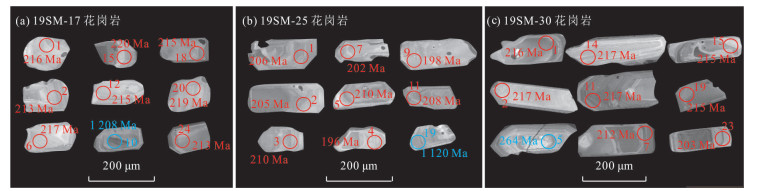
The Sumatra Island, located in the Tethyan tectonic domain, preserves abundant granitoids with various ages and petrogenesis. The paucity of precise geochronological data for these granitoids has hampered our understanding on the extension and tectonic setting of magmatic belts in Southeast Asia. Precise zircon U-Pb geochronological data for granites from the Sibolga area in western Sumatra are presented in this study. Our results suggest that zircon grains from these samples are of igneous origin. LA-ICP-MS zircon U-Pb dating yields crystallization ages of 215.1±2.4 Ma (MSWD=0.14), 206.1±5 Ma (MSWD=0.22) and 214.3±5 Ma (MSWD=0.11) for granites respectively, indicating the Late Triassic magmatism in western Sumatra. Comparing with those of contemporary igneous rocks in Southeast Asia, it proposes that the Late Triassic granites in the Sibolga area are consistent with the West Province granite. Therefore, these granites might be formed in a back-arc rift setting in response to the initial subduction of the Mesotethyan Ocean during the Late Triassic.
The Sumatra Island, located in the Tethyan tectonic domain, preserves abundant granitoids with various ages and petrogenesis. The paucity of precise geochronological data for these granitoids has hampered our understanding on the extension and tectonic setting of magmatic belts in Southeast Asia. Precise zircon U-Pb geochronological data for granites from the Sibolga area in western Sumatra are presented in this study. Our results suggest that zircon grains from these samples are of igneous origin. LA-ICP-MS zircon U-Pb dating yields crystallization ages of 215.1±2.4 Ma (MSWD=0.14), 206.1±5 Ma (MSWD=0.22) and 214.3±5 Ma (MSWD=0.11) for granites respectively, indicating the Late Triassic magmatism in western Sumatra. Comparing with those of contemporary igneous rocks in Southeast Asia, it proposes that the Late Triassic granites in the Sibolga area are consistent with the West Province granite. Therefore, these granites might be formed in a back-arc rift setting in response to the initial subduction of the Mesotethyan Ocean during the Late Triassic.


2021, 46(8): 2887-2902.
doi: 10.3799/dqkx.2020.270
Abstract:
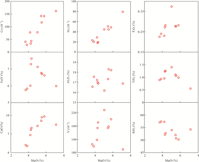
Sanukitoid with special genetic mechanism is one important petrological probe to study the magma dynamic processes and associated tectonic process. In this study, it presents petrology, geochronology, elemental geochemistry and Lu-Hf isotopic data on the Suolagou sanukitoid-like diorite in East Kunlun, aiming to characterize its petrogenesis and to reveal its implications on the Paleo-Tethyan orogeny. Zircon U-Pb dating shows that the Suolagou diorite was formed in the Middle Triassic (~243 Ma). Geochemically, they have low contents of SiO2(50.26%-57.40%), but high contents of total alkaline (Na2O+K2O=3.5%-6.3%), MgO (6.0%-7.1%) and high Mg# (50.1-60.9), belonging to high magnesium, calc-alkaline and metaluminous series. The Suolagou diorites show geochemical similarities to high Mg# andesitic sanukitoids with high contents of Sr (622×10-6-1 041×10-6), Cr (30×10-6-161×10-6) and Ni (19×10-6-79×10-6), and moderate contents of Y(7.6×10⁻⁶-24.3×10⁻⁶) and Yb(0.62×10⁻⁶-1.87×10⁻⁶). These rocks display remarkable enrichment in light rare earth elements and large-ion lithophile elements (such as Cs, Rb, K and Pb) but depletion in high-field strength elements (such as Ta, Nb and Zr), resembling the arc-related magmatic rocks above subduction zone. Lu-Hf isotopes show that the Suolagou diorites were derived from partial melting of enriched lithospheric mantle (εHf(t)=-2.4 to -0.4, TDM=0.89-0.99 Ga). The~243 Ma sanukitoid-like diorite in East Kunlun were formed in a continental arc setting, i.e., the parent magma derived from partial melting of enriched lithospheric mantle, subsequently followed by fractional crystallization of amphibole and biotite. This study suggests that the transition from Paleo-Tethyan oceanic slab subduction to terranes collision in East Kunlun occurred at Middle Triassic, and the Suolagou sanukitoid-like high-Mg diorites could be the magmatic response to the slab break-off at the end of subduction.
Sanukitoid with special genetic mechanism is one important petrological probe to study the magma dynamic processes and associated tectonic process. In this study, it presents petrology, geochronology, elemental geochemistry and Lu-Hf isotopic data on the Suolagou sanukitoid-like diorite in East Kunlun, aiming to characterize its petrogenesis and to reveal its implications on the Paleo-Tethyan orogeny. Zircon U-Pb dating shows that the Suolagou diorite was formed in the Middle Triassic (~243 Ma). Geochemically, they have low contents of SiO2(50.26%-57.40%), but high contents of total alkaline (Na2O+K2O=3.5%-6.3%), MgO (6.0%-7.1%) and high Mg# (50.1-60.9), belonging to high magnesium, calc-alkaline and metaluminous series. The Suolagou diorites show geochemical similarities to high Mg# andesitic sanukitoids with high contents of Sr (622×10-6-1 041×10-6), Cr (30×10-6-161×10-6) and Ni (19×10-6-79×10-6), and moderate contents of Y(7.6×10⁻⁶-24.3×10⁻⁶) and Yb(0.62×10⁻⁶-1.87×10⁻⁶). These rocks display remarkable enrichment in light rare earth elements and large-ion lithophile elements (such as Cs, Rb, K and Pb) but depletion in high-field strength elements (such as Ta, Nb and Zr), resembling the arc-related magmatic rocks above subduction zone. Lu-Hf isotopes show that the Suolagou diorites were derived from partial melting of enriched lithospheric mantle (εHf(t)=-2.4 to -0.4, TDM=0.89-0.99 Ga). The~243 Ma sanukitoid-like diorite in East Kunlun were formed in a continental arc setting, i.e., the parent magma derived from partial melting of enriched lithospheric mantle, subsequently followed by fractional crystallization of amphibole and biotite. This study suggests that the transition from Paleo-Tethyan oceanic slab subduction to terranes collision in East Kunlun occurred at Middle Triassic, and the Suolagou sanukitoid-like high-Mg diorites could be the magmatic response to the slab break-off at the end of subduction.


2021, 46(8): 2903-2918.
doi: 10.3799/dqkx.2020.325
Abstract:
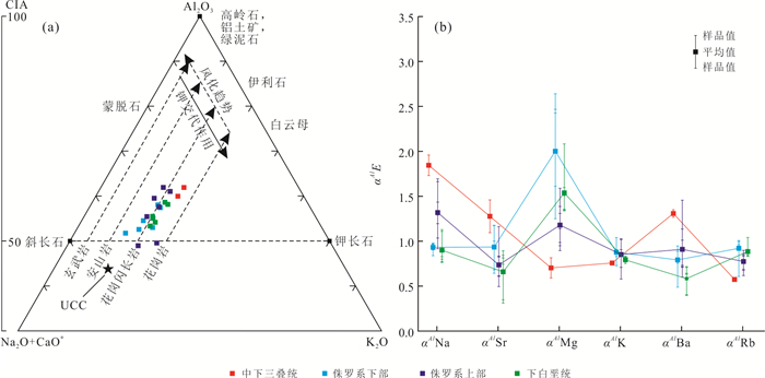
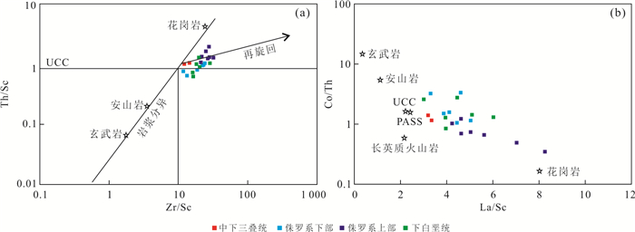
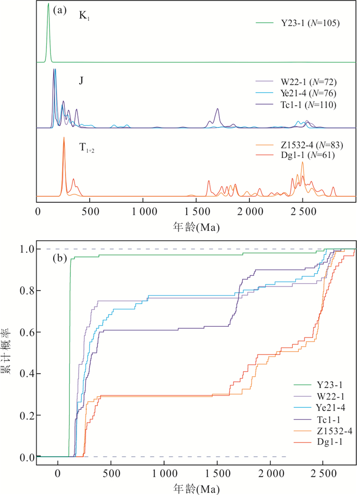
In Mesozoic, the Huanghua Depression was located in the center of the convergence and destruction of the North China Craton and was the sink place of all source areas. It recorded the evolution of the tectonic and provenance of the Mesozoic basins in North China. The main and trace elements of Mesozoic sandstones from the study area were examined. It is found that the average contents of SiO2, Al2O3, Na2O, K2O, and Fe2O3T are 66.98%, 13.65%, 2.74%, 3.03%, and 3.26%, respectively. The sandstones are litharenites, arkoses, and greywackes. The average CIA and ICV values are 56.12 and 0.94, and the sandstones experienced some chemical weathering and recycling. The parent rocks of the sandstones are feldspathic igneous rocks and recycling sedimentary rocks, mixed with a small amount of basic igneous rocks. From the Triassic to the Cretaceous, the source of Mesozoic sandstones gradually evolved from continental arc in the northern margin of North China to the paleo-uplift and the interplate magmatic area of the Yanshan orogenic belt and the Huanghua Depression.
In Mesozoic, the Huanghua Depression was located in the center of the convergence and destruction of the North China Craton and was the sink place of all source areas. It recorded the evolution of the tectonic and provenance of the Mesozoic basins in North China. The main and trace elements of Mesozoic sandstones from the study area were examined. It is found that the average contents of SiO2, Al2O3, Na2O, K2O, and Fe2O3T are 66.98%, 13.65%, 2.74%, 3.03%, and 3.26%, respectively. The sandstones are litharenites, arkoses, and greywackes. The average CIA and ICV values are 56.12 and 0.94, and the sandstones experienced some chemical weathering and recycling. The parent rocks of the sandstones are feldspathic igneous rocks and recycling sedimentary rocks, mixed with a small amount of basic igneous rocks. From the Triassic to the Cretaceous, the source of Mesozoic sandstones gradually evolved from continental arc in the northern margin of North China to the paleo-uplift and the interplate magmatic area of the Yanshan orogenic belt and the Huanghua Depression.


2021, 46(8): 2919-2933.
doi: 10.3799/dqkx.2020.264
Abstract:
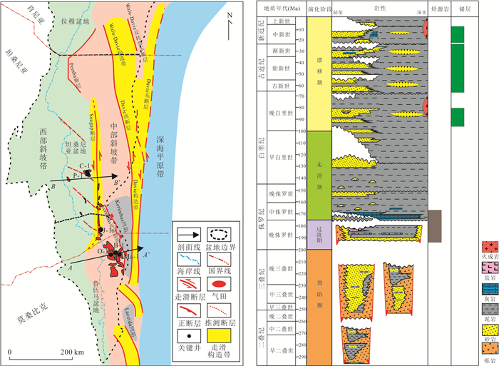
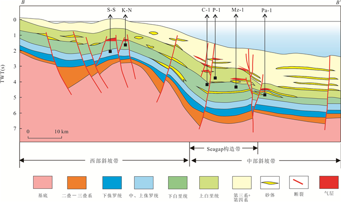
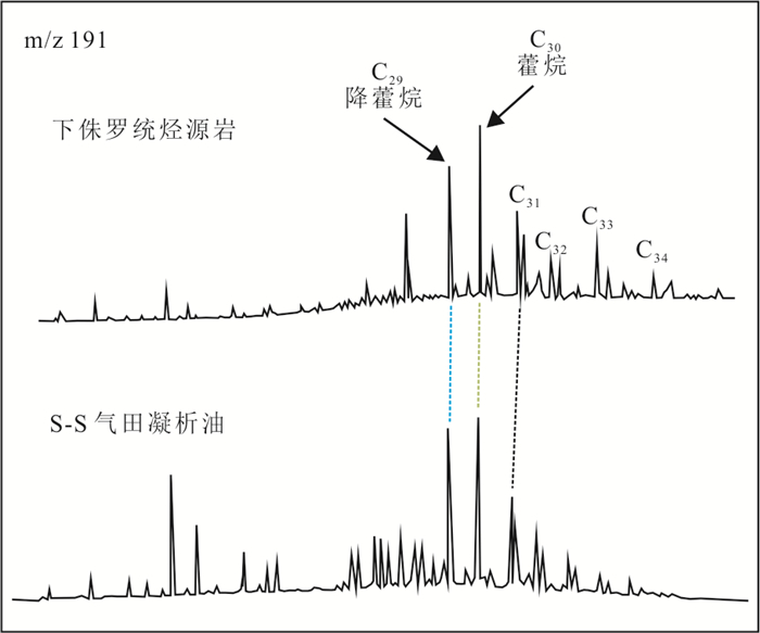
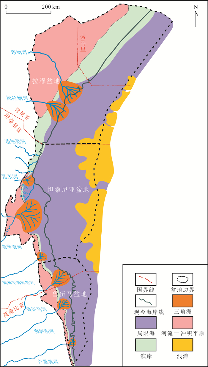
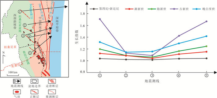
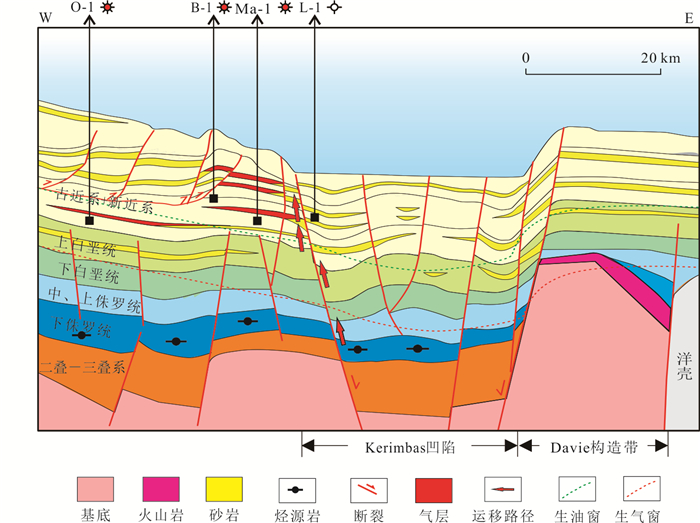
East Africa coastal basins are prolific in natural gas resources and are the hot spots of natural gas exploration in the world. The natural gas in the key East Africa coastal basins is sapropelic thermal gas, which mainly sourced from Lower Jurassic restricted marine high-quality source rocks. Large faults controlled the vertical migration of natural gas in the key East Africa coastal basins, where mainly developed large extensional faults and large strike-slip faults. The large strike-slip faults were main migration pathway of natural gas in the south of Tanzania Basin. Their main active period was from Late Cretaceous to Paleocene, which controlled the gas migration of the Cretaceous-Paleogene gas-bearing turbidite sandstone, while extensional faults were the main migration pathway of natural gas in Ruvuma Basin. Their main active period was Paleocene, Oligocene and Neogene, which controlled the gas migration of Paleogene gas-bearing turbidite sand stone. The type and size of turbidite sand controlled the size of lithological or structure-lithological trap in deepwater, and which in turn controlled the size of natural gas field. Due to the different migration modes of natural gas, East Africa coastal basins formed large strike-slip fault controlling accumulation model and large extensional fault controlling accumulation model.
East Africa coastal basins are prolific in natural gas resources and are the hot spots of natural gas exploration in the world. The natural gas in the key East Africa coastal basins is sapropelic thermal gas, which mainly sourced from Lower Jurassic restricted marine high-quality source rocks. Large faults controlled the vertical migration of natural gas in the key East Africa coastal basins, where mainly developed large extensional faults and large strike-slip faults. The large strike-slip faults were main migration pathway of natural gas in the south of Tanzania Basin. Their main active period was from Late Cretaceous to Paleocene, which controlled the gas migration of the Cretaceous-Paleogene gas-bearing turbidite sandstone, while extensional faults were the main migration pathway of natural gas in Ruvuma Basin. Their main active period was Paleocene, Oligocene and Neogene, which controlled the gas migration of Paleogene gas-bearing turbidite sand stone. The type and size of turbidite sand controlled the size of lithological or structure-lithological trap in deepwater, and which in turn controlled the size of natural gas field. Due to the different migration modes of natural gas, East Africa coastal basins formed large strike-slip fault controlling accumulation model and large extensional fault controlling accumulation model.


2021, 46(8): 2934-2943.
doi: 10.3799/dqkx.2020.327
Abstract:
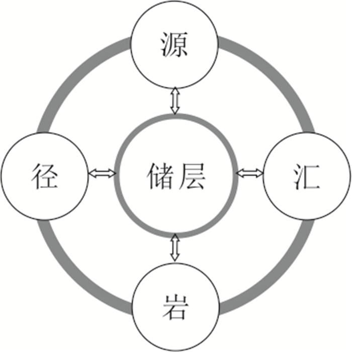
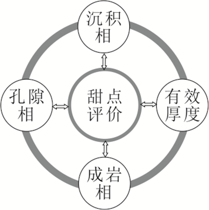
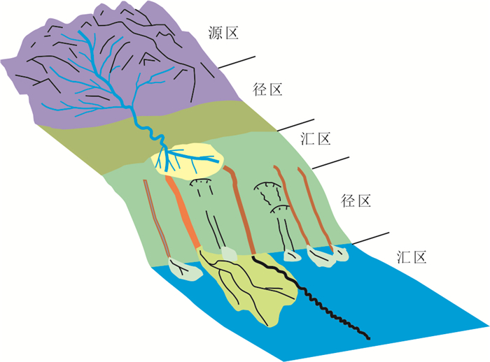
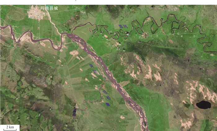
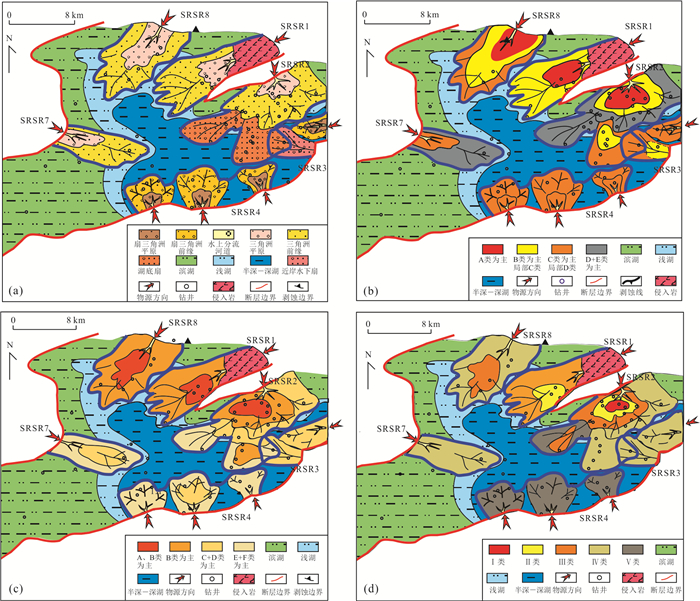
Complex oil and gas reservoirs have strong heterogeneity and complex "sweet spot" genetic control factors. Faced with the requirements of fine characterization and prediction, reservoir research needs to be improved from the research ideas and method system. The "source-sink" (S2S) system analysis developed based on basin sedimentology provides new ideas for the study of complex reservoir systems. In this paper, it further proposes the "source-route-sink-rock" (SRSR) system analysis ideas and methods, emphasizing the development of four sub-systems: "source-sediment material composition and source", "route-sediment transport process and path", "sink-sediment convergence accumulation environment and change", and "rock-sediment burial diagenetic process and diagenetic facies". The element composition of each subsystem in the reservoir research system is preliminarily established in this paper. The four subsystems jointly determine the macro and micro heterogeneity attributes and jointly determine the reservoir quality. Based on the source-sink division, sedimentary facies division and diagenetic facies division, we used the sweetness RSI index to classify regional reservoir "sweet spots" and applied it in the evaluation of low-permeability reservoirs in Wushi Depression, and achieved good results. Reservoir SRSR system analysis is a novel idea to the study of the genesis of complex "sweet spot" reservoirs, and it is the technology to follow for the fine characterization of complex heterogeneous reservoirs. It provides new theoretical and methodological support for quantitative evaluation and prediction of complex conventional reservoir, tight reservoir and unconventional shale reservoir.
Complex oil and gas reservoirs have strong heterogeneity and complex "sweet spot" genetic control factors. Faced with the requirements of fine characterization and prediction, reservoir research needs to be improved from the research ideas and method system. The "source-sink" (S2S) system analysis developed based on basin sedimentology provides new ideas for the study of complex reservoir systems. In this paper, it further proposes the "source-route-sink-rock" (SRSR) system analysis ideas and methods, emphasizing the development of four sub-systems: "source-sediment material composition and source", "route-sediment transport process and path", "sink-sediment convergence accumulation environment and change", and "rock-sediment burial diagenetic process and diagenetic facies". The element composition of each subsystem in the reservoir research system is preliminarily established in this paper. The four subsystems jointly determine the macro and micro heterogeneity attributes and jointly determine the reservoir quality. Based on the source-sink division, sedimentary facies division and diagenetic facies division, we used the sweetness RSI index to classify regional reservoir "sweet spots" and applied it in the evaluation of low-permeability reservoirs in Wushi Depression, and achieved good results. Reservoir SRSR system analysis is a novel idea to the study of the genesis of complex "sweet spot" reservoirs, and it is the technology to follow for the fine characterization of complex heterogeneous reservoirs. It provides new theoretical and methodological support for quantitative evaluation and prediction of complex conventional reservoir, tight reservoir and unconventional shale reservoir.


2021, 46(8): 2944-2957.
doi: 10.3799/dqkx.2020.305
Abstract:
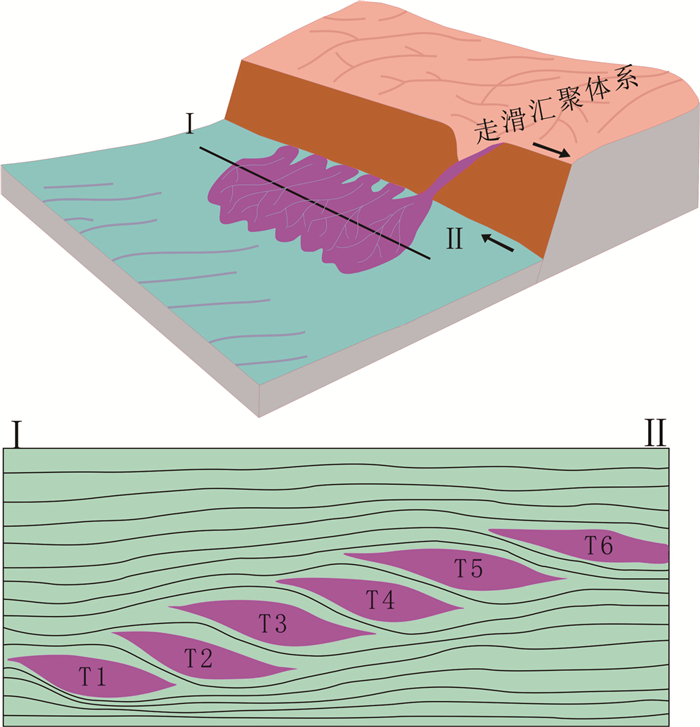
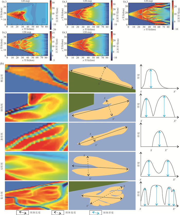
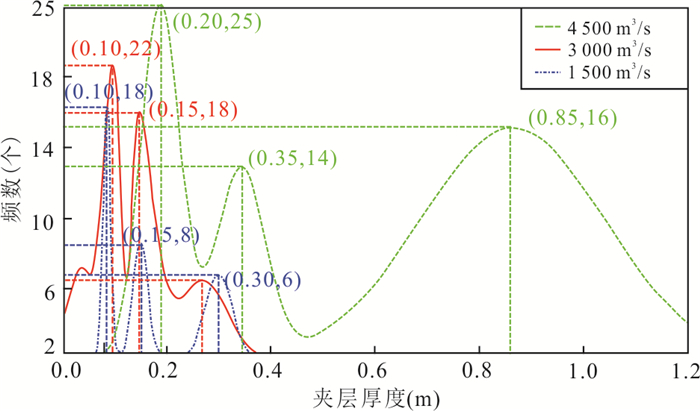
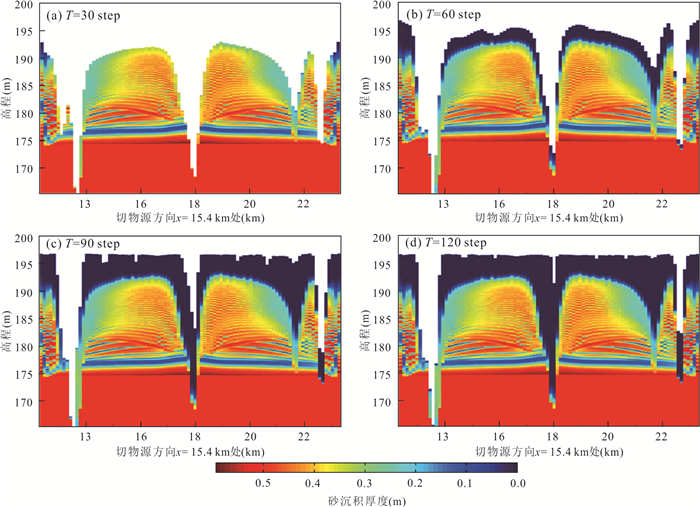
The complex sedimentary characteristics and internal structure of the tidal-controlled estuary dam are still unclear. By means of establishment of an ideal tidal-controlled estuary model, using sedimentary dynamics numerical simulation method, quantitative simulation of sedimentation of tidal-controlled estuary dam and internal interlayer was carried out under different flow and tidal energy conditions. The results show that under ideal conditions, large tidal range and medium flow are conducive to large-scale development of tidal-controlled estuary bars. In the analysis of tidal energy factors, the length-to-width ratio of the tidal-controlled estuary dam is 2-15, the length of the interlayer is concentrated at 8 km, and the thickness of the interlayer is 0.1-0.2 m. In the analysis of flow factors, the length-to-width ratio of the tidal-controlled estuary dam body is 1.5-9.0, the interlayer length is 1-2 km, and the interlayer thickness is 0.1-0.2 m. Simulation results show that the coupled action of the river and tide control the formation and distribution of the bar, but the effect of the tide is more remarkable. Numerical simulation of the sedimentary process of tidal-controlled estuaries based on sedimentary dynamics has been verified by well seismic data, which will provide new ideas for the sedimentary evolution of tidal-controlled estuaries and will guide the exploration and development of oil-bearing reservoirs in the tidal-controlled estuary.
The complex sedimentary characteristics and internal structure of the tidal-controlled estuary dam are still unclear. By means of establishment of an ideal tidal-controlled estuary model, using sedimentary dynamics numerical simulation method, quantitative simulation of sedimentation of tidal-controlled estuary dam and internal interlayer was carried out under different flow and tidal energy conditions. The results show that under ideal conditions, large tidal range and medium flow are conducive to large-scale development of tidal-controlled estuary bars. In the analysis of tidal energy factors, the length-to-width ratio of the tidal-controlled estuary dam is 2-15, the length of the interlayer is concentrated at 8 km, and the thickness of the interlayer is 0.1-0.2 m. In the analysis of flow factors, the length-to-width ratio of the tidal-controlled estuary dam body is 1.5-9.0, the interlayer length is 1-2 km, and the interlayer thickness is 0.1-0.2 m. Simulation results show that the coupled action of the river and tide control the formation and distribution of the bar, but the effect of the tide is more remarkable. Numerical simulation of the sedimentary process of tidal-controlled estuaries based on sedimentary dynamics has been verified by well seismic data, which will provide new ideas for the sedimentary evolution of tidal-controlled estuaries and will guide the exploration and development of oil-bearing reservoirs in the tidal-controlled estuary.


2021, 46(8): 2958-2972.
doi: 10.3799/dqkx.2020.318
Abstract:
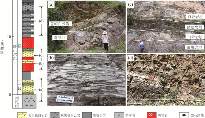
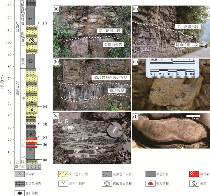
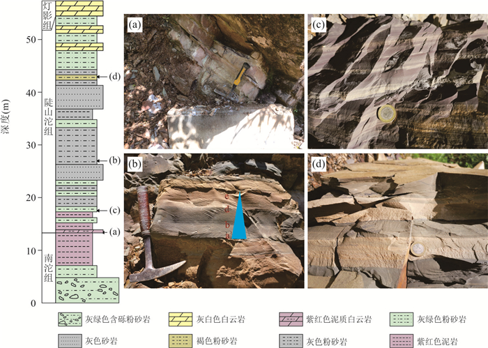
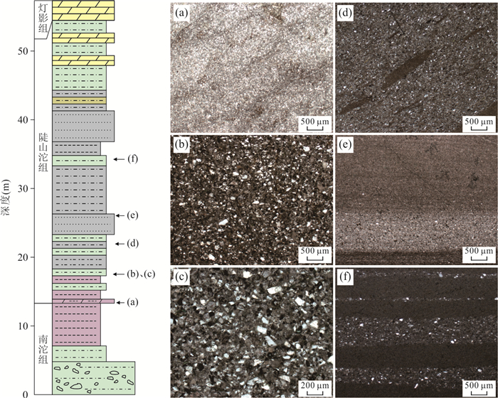
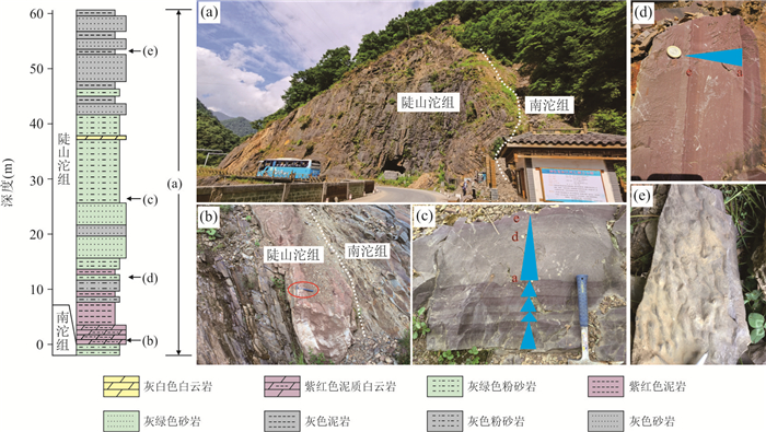
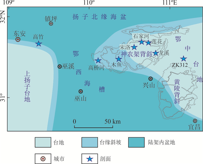
Paleogeographic reconstruction of the Ediacaran Doushantuo Formation in South China is controversial, and one of the key problems is the existence and distribution of the "West Hubei Trough". In this paper it presents stratigraphic and sedimentological evidence of the Doushantuo Formation from the Shennongjia area (Hubei Province) for the existence of "West Hubei Trough" and its sedimentary facies in Shennongjia area. Lithological features of the Doushantuo Formation in the eastern Shennongjia area are similar to those in the Zhangcunping area, northern Huangling anticline near Three Gorges. Sedimentary structures such as "bird eyes" and peloids indicate that the Doushantuo Formation in the eastern Shennongjia area was deposited in a shallow platform environment. The Doushantuo Formation in the western Shennongjia area is mainly composed of interbedded sandstone, siltstone and mudstone. In addition, sedimentary structures, such as incomplete Bouma sequences containing normal graded bedding and parallel bedding, indicate a slope or relatively deeper water environment of the western Shennongjia area. In combination with previous studies, our results indicate that the boundary between the "West Hubei Trough" and the "Central Hubei Platform" extends from the middle Shennongjia area to the northwest of Huangling anticline area as well as to its southeast. The eastern Shennongjia and northeast Huangling anticline were both located in platform facies, whereas the western Shennongjia and southwest Huangling anticline were located in deeper water facies of the "West Hubei Trough".
Paleogeographic reconstruction of the Ediacaran Doushantuo Formation in South China is controversial, and one of the key problems is the existence and distribution of the "West Hubei Trough". In this paper it presents stratigraphic and sedimentological evidence of the Doushantuo Formation from the Shennongjia area (Hubei Province) for the existence of "West Hubei Trough" and its sedimentary facies in Shennongjia area. Lithological features of the Doushantuo Formation in the eastern Shennongjia area are similar to those in the Zhangcunping area, northern Huangling anticline near Three Gorges. Sedimentary structures such as "bird eyes" and peloids indicate that the Doushantuo Formation in the eastern Shennongjia area was deposited in a shallow platform environment. The Doushantuo Formation in the western Shennongjia area is mainly composed of interbedded sandstone, siltstone and mudstone. In addition, sedimentary structures, such as incomplete Bouma sequences containing normal graded bedding and parallel bedding, indicate a slope or relatively deeper water environment of the western Shennongjia area. In combination with previous studies, our results indicate that the boundary between the "West Hubei Trough" and the "Central Hubei Platform" extends from the middle Shennongjia area to the northwest of Huangling anticline area as well as to its southeast. The eastern Shennongjia and northeast Huangling anticline were both located in platform facies, whereas the western Shennongjia and southwest Huangling anticline were located in deeper water facies of the "West Hubei Trough".


2021, 46(8): 2973-2983.
doi: 10.3799/dqkx.2020.273
Abstract:
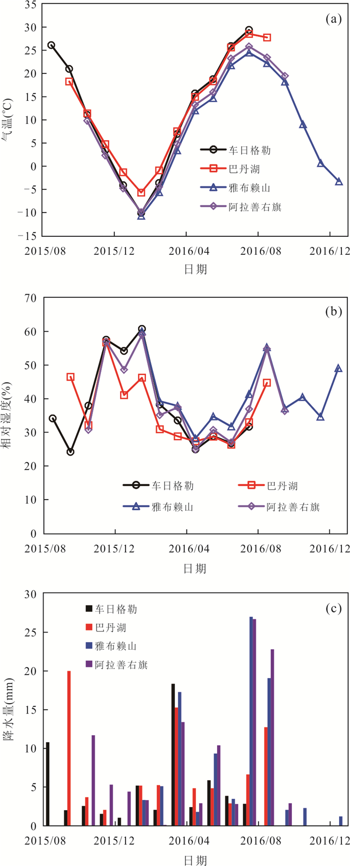
Understanding the isotopic characteristics of precipitation in desert is helpful to study the water cycle process in arid areas. According to the precipitation samples from 4 stations in the Badain Jaran Desert from 2015 to 2016, the temporal and spatial distribution characteristics and influencing factors of δ2H and δ18O were analyzed. The source of precipitation moisture was analyzed with the backward air mass trajectory model and the recycled moisture fractions were calculated with deuterium excess. The results show that the precipitations of δ2H and δ18O show seasonal effect, which are higher in summer and lower in winter. The precipitations of δ2H and δ18O in the hinterland of desert are more positive and d-excess is more negative than that in the surrounding mountainous areas, reflecting the stronger evaporation of precipitation in the hinterland. The annual precipitation is mainly from the westerly moisture, and the summer precipitation is affected by the southeast monsoon. The recycled moisture fraction in desert is 10.3%-10.9%, which is slightly larger than 8.5% of mountainous area; the recycled moisture accounts for 11.1% of the total evaporation, which reflects that the contribution of strong evaporation in desert to local precipitation is relatively limited.
Understanding the isotopic characteristics of precipitation in desert is helpful to study the water cycle process in arid areas. According to the precipitation samples from 4 stations in the Badain Jaran Desert from 2015 to 2016, the temporal and spatial distribution characteristics and influencing factors of δ2H and δ18O were analyzed. The source of precipitation moisture was analyzed with the backward air mass trajectory model and the recycled moisture fractions were calculated with deuterium excess. The results show that the precipitations of δ2H and δ18O show seasonal effect, which are higher in summer and lower in winter. The precipitations of δ2H and δ18O in the hinterland of desert are more positive and d-excess is more negative than that in the surrounding mountainous areas, reflecting the stronger evaporation of precipitation in the hinterland. The annual precipitation is mainly from the westerly moisture, and the summer precipitation is affected by the southeast monsoon. The recycled moisture fraction in desert is 10.3%-10.9%, which is slightly larger than 8.5% of mountainous area; the recycled moisture accounts for 11.1% of the total evaporation, which reflects that the contribution of strong evaporation in desert to local precipitation is relatively limited.


2021, 46(8): 2984-2998.
doi: 10.3799/dqkx.2020.267
Abstract:
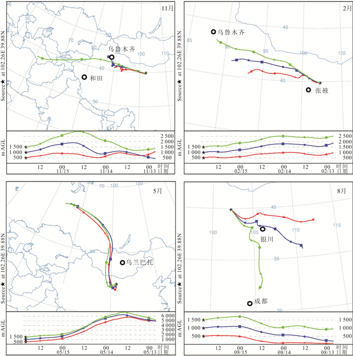
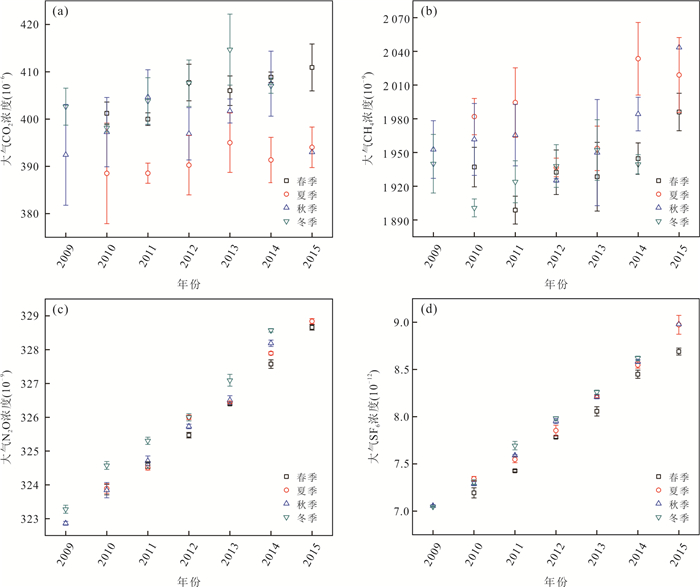
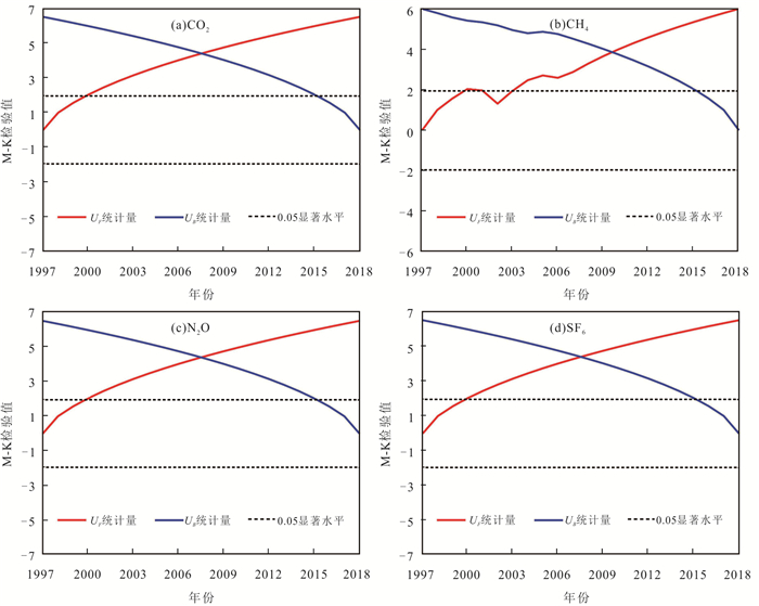
Studying the changes of atmospheric greenhouse gases in typical regions will help effectively cope with climate change, slow global warming and reduce extreme climate events. In this paper, monthly data and the linear trend analysis method and Mann-Kendall mutation test method were used to analyze the characteristics of time series and seasonal variations of atmospheric greenhouse gases at Waliguan station during 1997-2018 and Shangdianzi station during 2009-2015. The HYSPLIT backward trajectory model was established to analyze the potential impacts of monsoon transportation and atmospheric boundary layer conditions on greenhouse gases. The greenhouse gases at both Waliguan and Shangdianzi stations significantly increased year by year, with obvious seasonal variations. Atmospheric CO2 at the two stations fell to the lowest in August, atmospheric CH4 reached peaks in August, and SF6 reached its maximum values in August and September, respectively. Atmospheric N2O at Waliguan station reached the highest in December and fell to the lowest in June, while atmospheric N2O at Shangdianzi station reached peaks in July and fell to its lowest in September. Atmospheric greenhouse gases at both Waliguan and Shangdianzi were affected by various factors such as local biological and non-biological sources, long-distance monsoon transportation, atmospheric boundary layer conditions and photochemical processes.
Studying the changes of atmospheric greenhouse gases in typical regions will help effectively cope with climate change, slow global warming and reduce extreme climate events. In this paper, monthly data and the linear trend analysis method and Mann-Kendall mutation test method were used to analyze the characteristics of time series and seasonal variations of atmospheric greenhouse gases at Waliguan station during 1997-2018 and Shangdianzi station during 2009-2015. The HYSPLIT backward trajectory model was established to analyze the potential impacts of monsoon transportation and atmospheric boundary layer conditions on greenhouse gases. The greenhouse gases at both Waliguan and Shangdianzi stations significantly increased year by year, with obvious seasonal variations. Atmospheric CO2 at the two stations fell to the lowest in August, atmospheric CH4 reached peaks in August, and SF6 reached its maximum values in August and September, respectively. Atmospheric N2O at Waliguan station reached the highest in December and fell to the lowest in June, while atmospheric N2O at Shangdianzi station reached peaks in July and fell to its lowest in September. Atmospheric greenhouse gases at both Waliguan and Shangdianzi were affected by various factors such as local biological and non-biological sources, long-distance monsoon transportation, atmospheric boundary layer conditions and photochemical processes.


2021, 46(8): 2999-3011.
doi: 10.3799/dqkx.2020.260
Abstract:
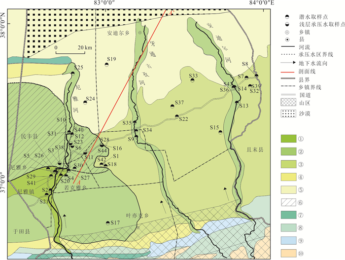
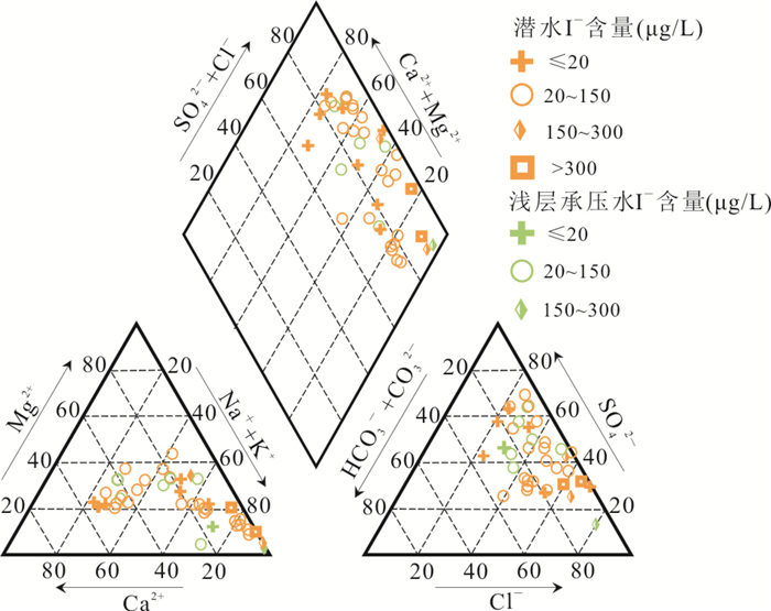
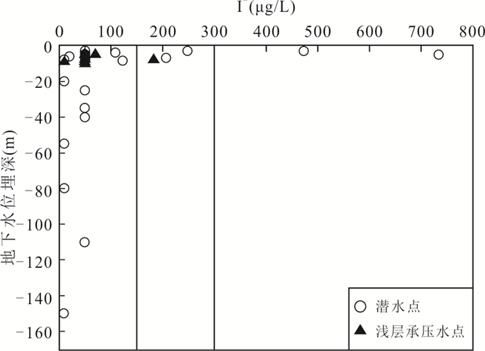
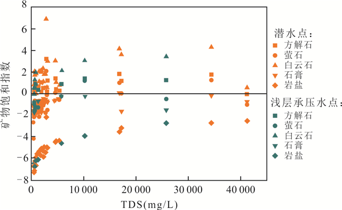
Tarim Basin is located in the hinterland of Eurasia, far away from the sea. Groundwater is an important source of water supply in the southern margin of Tarim Basin. Based on the 44 groups of shallow groundwater samples from the plain area of Minfeng County in the southern margin of Tarim Basin, Xinjiang Uygur Autonomous Region, the hydrochemical characteristics of unconfined groundwater and shallow confined groundwater, the spatial distribution of iodine and the causes of the high-iodine groundwater were analyzed by using the hydrochemical graphic method, mathematical statistics method and geographic information system (GIS) techniques. The results show that iodine enrichment and iodine deficiency coexist in groundwater in plain area of Minfeng County. The I- contents in unconfined groundwater and shallow confined groundwater were ≤ 730 μg/L and ≤ 183 μg/L respectively. The proportions of iodine deficient water, suitable iodine water, high iodine water and ultra-high iodine water in unconfined groundwater samples were 19.4%, 69.4%, 5.6% and 5.6%, respectively. The proportions of iodine deficient groundwater, suitable iodine water and high iodine water in shallow confined groundwater samples were 12.5%, 75.0% and 12.5%, respectively. From the sloping plain in front of the mountain to the plain in the fine earth, the I- content in the groundwater increased obviously. The main hydrochemical types of high iodine groundwater and ultra-high iodine groundwater are Cl·SO4-Na and Cl-Na. In addition to the hydrogeological conditions and alkaline groundwater environment, iodine content in unconfined groundwater is mainly affected by strong evaporation and concentration, Quaternary Holocene swamp deposits and mineral dissolution precipitation, and the shallow confined groundwater is mainly affected by mineral dissolution precipitation and reduction environment.
Tarim Basin is located in the hinterland of Eurasia, far away from the sea. Groundwater is an important source of water supply in the southern margin of Tarim Basin. Based on the 44 groups of shallow groundwater samples from the plain area of Minfeng County in the southern margin of Tarim Basin, Xinjiang Uygur Autonomous Region, the hydrochemical characteristics of unconfined groundwater and shallow confined groundwater, the spatial distribution of iodine and the causes of the high-iodine groundwater were analyzed by using the hydrochemical graphic method, mathematical statistics method and geographic information system (GIS) techniques. The results show that iodine enrichment and iodine deficiency coexist in groundwater in plain area of Minfeng County. The I- contents in unconfined groundwater and shallow confined groundwater were ≤ 730 μg/L and ≤ 183 μg/L respectively. The proportions of iodine deficient water, suitable iodine water, high iodine water and ultra-high iodine water in unconfined groundwater samples were 19.4%, 69.4%, 5.6% and 5.6%, respectively. The proportions of iodine deficient groundwater, suitable iodine water and high iodine water in shallow confined groundwater samples were 12.5%, 75.0% and 12.5%, respectively. From the sloping plain in front of the mountain to the plain in the fine earth, the I- content in the groundwater increased obviously. The main hydrochemical types of high iodine groundwater and ultra-high iodine groundwater are Cl·SO4-Na and Cl-Na. In addition to the hydrogeological conditions and alkaline groundwater environment, iodine content in unconfined groundwater is mainly affected by strong evaporation and concentration, Quaternary Holocene swamp deposits and mineral dissolution precipitation, and the shallow confined groundwater is mainly affected by mineral dissolution precipitation and reduction environment.


2021, 46(8): 3012-3018.
doi: 10.3799/dqkx.2020.296
Abstract:
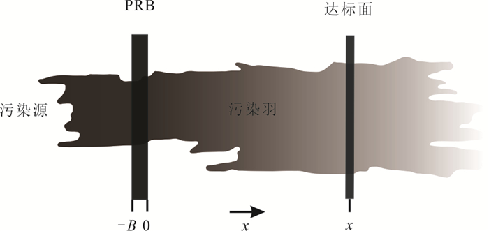
Permeable Reactive Barrier (PRB) technology is one of the most popular technologies for in-situ groundwater or soil remediation. A key task of design and installation is to calculate the thickness of the PRB. Most of the existing models of calculating the PRB thickness only consider the single species or the reaction barrier itself, with little consideration of a variety of contaminants and the combination of the aquifers. The response to PRB and aquifer multi-domain system, the convection dispersion equation of multi-species under one-dimensional condition was established. The analytical solution of the equation was obtained by using a conversion algorithm proposed by related literature, and the formula of the new PRB thickness was deduced at the same time, and then the numerical model was built based on the software COMSOL to validate this analytical solution. After comparing the required PRB thickness calculated from this study and previously developed Rabideau models, the aquifer reaction capability is found to be non-negligible for the determination of the required thickness of the PRB especially when the compliance plane becoming far from the PRB exit face. For the remediation multiple species sharing a single parental species, the correctness in the boundary and the domain conditions are crucial to estimate the effective thickness of a PRB. The proposed analytical solution provides meaningful designing insights for the PRB design and installation.
Permeable Reactive Barrier (PRB) technology is one of the most popular technologies for in-situ groundwater or soil remediation. A key task of design and installation is to calculate the thickness of the PRB. Most of the existing models of calculating the PRB thickness only consider the single species or the reaction barrier itself, with little consideration of a variety of contaminants and the combination of the aquifers. The response to PRB and aquifer multi-domain system, the convection dispersion equation of multi-species under one-dimensional condition was established. The analytical solution of the equation was obtained by using a conversion algorithm proposed by related literature, and the formula of the new PRB thickness was deduced at the same time, and then the numerical model was built based on the software COMSOL to validate this analytical solution. After comparing the required PRB thickness calculated from this study and previously developed Rabideau models, the aquifer reaction capability is found to be non-negligible for the determination of the required thickness of the PRB especially when the compliance plane becoming far from the PRB exit face. For the remediation multiple species sharing a single parental species, the correctness in the boundary and the domain conditions are crucial to estimate the effective thickness of a PRB. The proposed analytical solution provides meaningful designing insights for the PRB design and installation.


2021, 46(8): 3019-3027.
doi: 10.3799/dqkx.2020.389
Abstract:
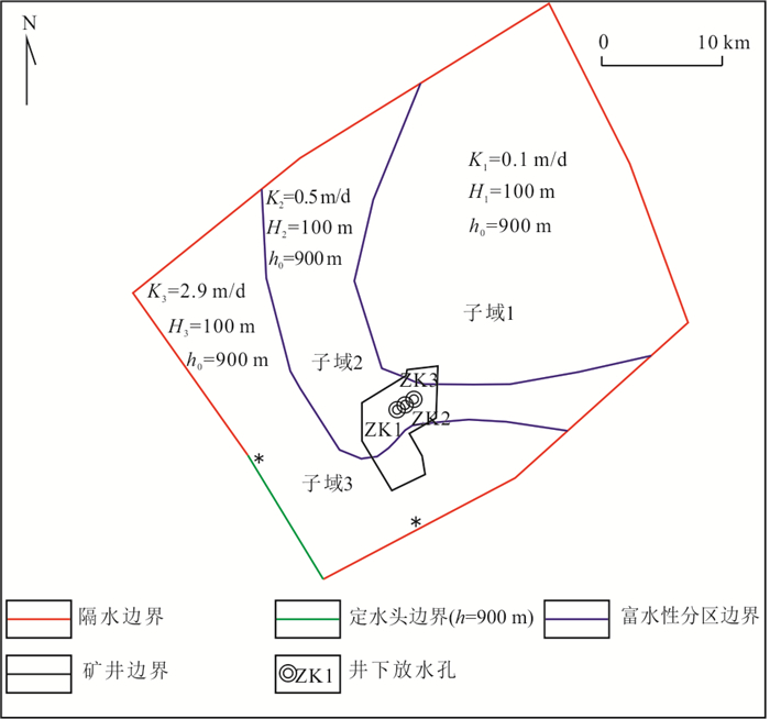
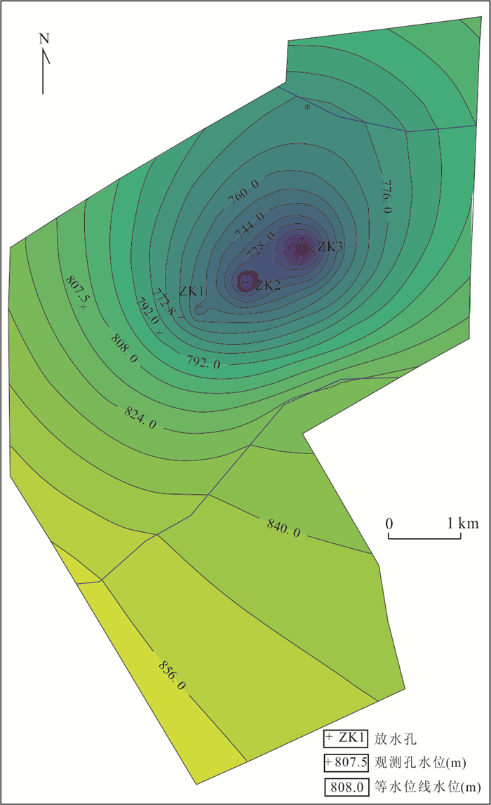
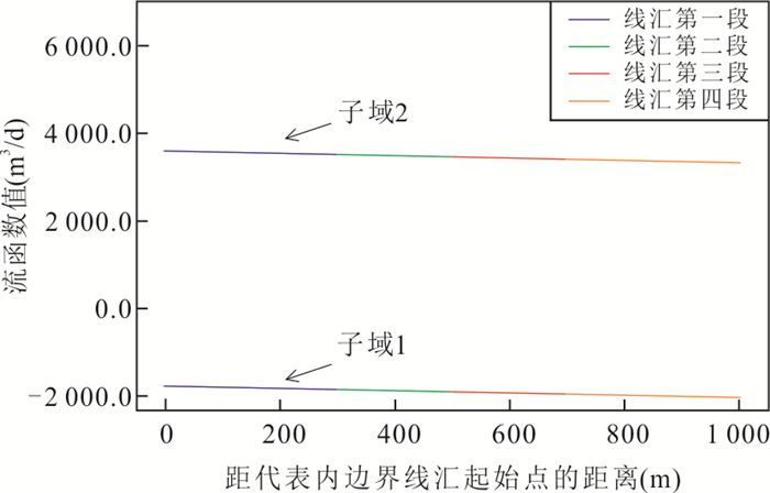
In order to analyze the feasibility of applying the subdomain-analytic element method to the simulation of coal mine groundwater flow field, and to explore how to improve the simulation accuracy of this method, complex potential expression of nonlinear density distribution high-order line-sink of analytic element method was derived independently here, and spatial distribution characteristics of values of discharge potential and stream function on line-sink were analyzed. On the basis of that, the flow field model of coal mine was constructed with python language based on subdomains-analytic element method which was used for solving a problem concerning the distribution of head in a coal mine after drainage test. According to the simulation results, the absolute value of the deviation between the simulated heads and the heads of the observation holes ranges from 1.36 m to 5.27 m, and the heads on the outer boundaries of the model (actual constant head boundaries) are close to the actual value (900 m), and the flow rates passing through the outer boundaries of the model (actual impermeable boundaries) approximate zero. The analysis of the simulation principle and simulation results show that the coal mine groundwater flow field model based on the subdomain-analytic element method satisfies the conservation of mass and the gradient field of Darcy flow in the whole area, and the head at any point in the whole area can be determined using the discharge potential function of the subdomain where the point is located in. Therefore, it is feasible to apply the subdomain-analytic element method to simulate the groundwater flow field of coal mine; and the nonlinear density distribution line-sinks representing the model boundaries can be divided into shorter lengths to further improve the accuracy of the simulation.
In order to analyze the feasibility of applying the subdomain-analytic element method to the simulation of coal mine groundwater flow field, and to explore how to improve the simulation accuracy of this method, complex potential expression of nonlinear density distribution high-order line-sink of analytic element method was derived independently here, and spatial distribution characteristics of values of discharge potential and stream function on line-sink were analyzed. On the basis of that, the flow field model of coal mine was constructed with python language based on subdomains-analytic element method which was used for solving a problem concerning the distribution of head in a coal mine after drainage test. According to the simulation results, the absolute value of the deviation between the simulated heads and the heads of the observation holes ranges from 1.36 m to 5.27 m, and the heads on the outer boundaries of the model (actual constant head boundaries) are close to the actual value (900 m), and the flow rates passing through the outer boundaries of the model (actual impermeable boundaries) approximate zero. The analysis of the simulation principle and simulation results show that the coal mine groundwater flow field model based on the subdomain-analytic element method satisfies the conservation of mass and the gradient field of Darcy flow in the whole area, and the head at any point in the whole area can be determined using the discharge potential function of the subdomain where the point is located in. Therefore, it is feasible to apply the subdomain-analytic element method to simulate the groundwater flow field of coal mine; and the nonlinear density distribution line-sinks representing the model boundaries can be divided into shorter lengths to further improve the accuracy of the simulation.


2021, 46(8): 3028-3038.
doi: 10.3799/dqkx.2020.386
Abstract:
Geological mapping in Gobi Desert covered area is one of the significant contents of geological survey in the new period of geological investigation. The basic objectives of geological mapping in covered area include two aspects: one is to reveal the geological structure of bedrock under overburden, i.e., to draw geological map of the bedrock; and the other is to reveal the geological structure of overburden, including the framework of overburden and the three-dimensional geological structure of overburden. Comprehensive geophysical surveys can be used to obtain the information of the geological structure, rock nature, distribution and layer-structure of sediment, etc. in covered area. Since economy and efficiency are key factors for geological mapping, selection and comprehensive implementation of geophysical methods are important to the investigation. Based on the recent geological mapping work in the East Tianshan mountains, Xinjiang, it proposed an optimal and effective integrated geophysical survey method for dealing with the geological mapping issue under multi-layer overburden in this paper. The integrated geophysical investigation and application of new technology in Barkol Basin and Hami Basin illustrate the efficiency and practicability of the comprehensive method. It may provide a reasonable solution to delineate covered rocks and structures in geological survey in Gobi Desert covered area.
Geological mapping in Gobi Desert covered area is one of the significant contents of geological survey in the new period of geological investigation. The basic objectives of geological mapping in covered area include two aspects: one is to reveal the geological structure of bedrock under overburden, i.e., to draw geological map of the bedrock; and the other is to reveal the geological structure of overburden, including the framework of overburden and the three-dimensional geological structure of overburden. Comprehensive geophysical surveys can be used to obtain the information of the geological structure, rock nature, distribution and layer-structure of sediment, etc. in covered area. Since economy and efficiency are key factors for geological mapping, selection and comprehensive implementation of geophysical methods are important to the investigation. Based on the recent geological mapping work in the East Tianshan mountains, Xinjiang, it proposed an optimal and effective integrated geophysical survey method for dealing with the geological mapping issue under multi-layer overburden in this paper. The integrated geophysical investigation and application of new technology in Barkol Basin and Hami Basin illustrate the efficiency and practicability of the comprehensive method. It may provide a reasonable solution to delineate covered rocks and structures in geological survey in Gobi Desert covered area.


2021, 46(8): 3039-3048.
doi: 10.3799/dqkx.2020.309
Abstract:
Geological entity is the key and core information in geological texts, and its accurate recognition is an important prerequisite for geological information extraction and mining. The ELMO-CNN-BiLSTM-CRF model is designed in this paper. Based on the pre-trained word vector, the deep BiLSTM-CRF neural network model is constructed. By adding dynamic features of words and character-level features of words, it makes up for the lack of specificity of word vectors, improves the recognition level of complex multi-word meanings in geological text and the ability to extract local features of geological entities. Taking the geological survey report of Xiongcun copper mine in Xietongmen County of Xizang Autonomous Region as an example, the performance of the model is evaluated. The accuracy rate, recall rate and F1 value of the model are 95.15%, 95.26% and 95.21% respectively. Experiments show that compared with BiLSTM-CRF and CNN-BiLSTM-CRF models, this model is more effective in small-scale corpus geological entity recognition, and can effectively identify long geological entity words and geological polysemants.
Geological entity is the key and core information in geological texts, and its accurate recognition is an important prerequisite for geological information extraction and mining. The ELMO-CNN-BiLSTM-CRF model is designed in this paper. Based on the pre-trained word vector, the deep BiLSTM-CRF neural network model is constructed. By adding dynamic features of words and character-level features of words, it makes up for the lack of specificity of word vectors, improves the recognition level of complex multi-word meanings in geological text and the ability to extract local features of geological entities. Taking the geological survey report of Xiongcun copper mine in Xietongmen County of Xizang Autonomous Region as an example, the performance of the model is evaluated. The accuracy rate, recall rate and F1 value of the model are 95.15%, 95.26% and 95.21% respectively. Experiments show that compared with BiLSTM-CRF and CNN-BiLSTM-CRF models, this model is more effective in small-scale corpus geological entity recognition, and can effectively identify long geological entity words and geological polysemants.