2021 Vol. 46, No. 9
Display Method:
 PDF 406KB
2021, 46(9): 3049-3056.
doi: 10.3799/dqkx.2020.323
Abstract:
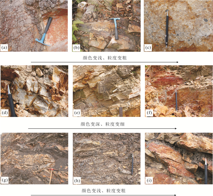
In this paper, a classification scheme is proposed for the common metamorphic rocks. In this scheme, the fabric-components reflecting both the structure-texture and compositions of metamorphic rocks are used as the first-order index, and the texture, structure and mineral composition are sequentially used as the secondary-, third- and fourth-order indexes for classification of the five genetic types of orogenic-regional, contact thermal, fault-related dynamic, altered-metasomatic metamorphic and migmatitic rocks. When geological occurrence of rocks is clear, the genetic type can replace the corresponding fabric component and becomes the first-order index for classification with the same procedures. Most orogenic-regional and contact thermal metamorphic rocks share the same names and features due to having the same fabric-components. However, it would be easy to distinguish a regional rock from a contact one according to their mode of occurrence and other characteristic microstructures of some diagnostic minerals. The effect of this classification is better than the petrographic classification schemes available in the world.
In this paper, a classification scheme is proposed for the common metamorphic rocks. In this scheme, the fabric-components reflecting both the structure-texture and compositions of metamorphic rocks are used as the first-order index, and the texture, structure and mineral composition are sequentially used as the secondary-, third- and fourth-order indexes for classification of the five genetic types of orogenic-regional, contact thermal, fault-related dynamic, altered-metasomatic metamorphic and migmatitic rocks. When geological occurrence of rocks is clear, the genetic type can replace the corresponding fabric component and becomes the first-order index for classification with the same procedures. Most orogenic-regional and contact thermal metamorphic rocks share the same names and features due to having the same fabric-components. However, it would be easy to distinguish a regional rock from a contact one according to their mode of occurrence and other characteristic microstructures of some diagnostic minerals. The effect of this classification is better than the petrographic classification schemes available in the world.
2021, 46(9): 3057-3073.
doi: 10.3799/dqkx.2020.335
Abstract:
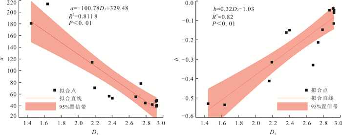
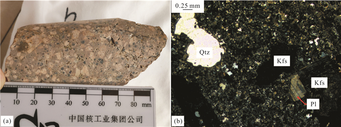
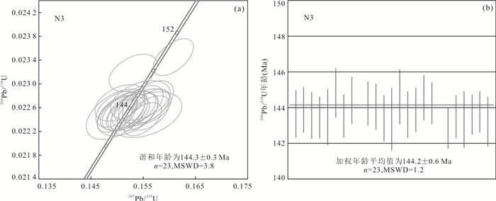
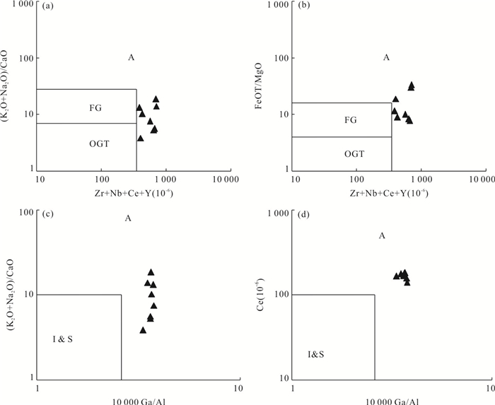
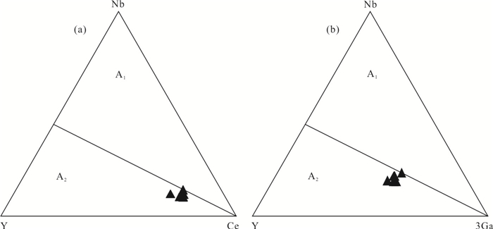
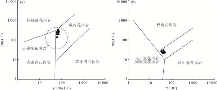
In order to understand the long-range function of the Mongolian-Okhotsk tectonic system and its influence range to the south in China. Zircon U-Pb isotopic geochronology, rock geochemistry and regional correlation of rhyolite porphyry were carried out in yangpangou area, Duolun volcanic basin, Inner Mongolia. Zircon LA-ICP-MS U-Pb isotopic dating shows that the age of its formation is 144.2±0.6 Ma, belonging to the early Early Cretaceous. The content of SiO2 is 73.25%-76.72%, K2O is 4.64%-7.87%, K2O/Na2O is 1.15-3.82, and A/CNK is 0.79-0.99. The accessory minerals are mainly magnetite, zircon and apatite. It belongs to the type A2 rhyolite of the quasi aluminous high potassium Ca-alkaline shoshonite series. The total amount of rare-earth elements is high (320.76×10⁻⁶-415.70×10⁻⁶). Light rare-earth elements, large ion lithophile elements K, Rb and high field strength elements U, Th, Zr and Hf are enriched. Heavy rare-earth elements, large ion lithophile elements Ba, Sr and high field strength elements P, Ti, Nb, Ta are deficient. Eu negative abnormality is significant (δEu=0.08-0.15). The above characteristics indicate that the rhyolite porphyry was formed in the background of post-collision, reflecting the post-collisional extension event after the closure of Mongolia-Okhotsk Ocean in Early Cretaceous. Therefore, the influence range of the Mongolia-Okhotsk tectonic system in China extends to the southeast at least to the southeast of Inner Mongolia to the north of Hebei, and the completion time of the corresponding Mongolia-Okhotsk Ocean east section should be earlier than 144.2 Ma.
In order to understand the long-range function of the Mongolian-Okhotsk tectonic system and its influence range to the south in China. Zircon U-Pb isotopic geochronology, rock geochemistry and regional correlation of rhyolite porphyry were carried out in yangpangou area, Duolun volcanic basin, Inner Mongolia. Zircon LA-ICP-MS U-Pb isotopic dating shows that the age of its formation is 144.2±0.6 Ma, belonging to the early Early Cretaceous. The content of SiO2 is 73.25%-76.72%, K2O is 4.64%-7.87%, K2O/Na2O is 1.15-3.82, and A/CNK is 0.79-0.99. The accessory minerals are mainly magnetite, zircon and apatite. It belongs to the type A2 rhyolite of the quasi aluminous high potassium Ca-alkaline shoshonite series. The total amount of rare-earth elements is high (320.76×10⁻⁶-415.70×10⁻⁶). Light rare-earth elements, large ion lithophile elements K, Rb and high field strength elements U, Th, Zr and Hf are enriched. Heavy rare-earth elements, large ion lithophile elements Ba, Sr and high field strength elements P, Ti, Nb, Ta are deficient. Eu negative abnormality is significant (δEu=0.08-0.15). The above characteristics indicate that the rhyolite porphyry was formed in the background of post-collision, reflecting the post-collisional extension event after the closure of Mongolia-Okhotsk Ocean in Early Cretaceous. Therefore, the influence range of the Mongolia-Okhotsk tectonic system in China extends to the southeast at least to the southeast of Inner Mongolia to the north of Hebei, and the completion time of the corresponding Mongolia-Okhotsk Ocean east section should be earlier than 144.2 Ma.


2021, 46(9): 3074-3090.
doi: 10.3799/dqkx.2021.061
Abstract:
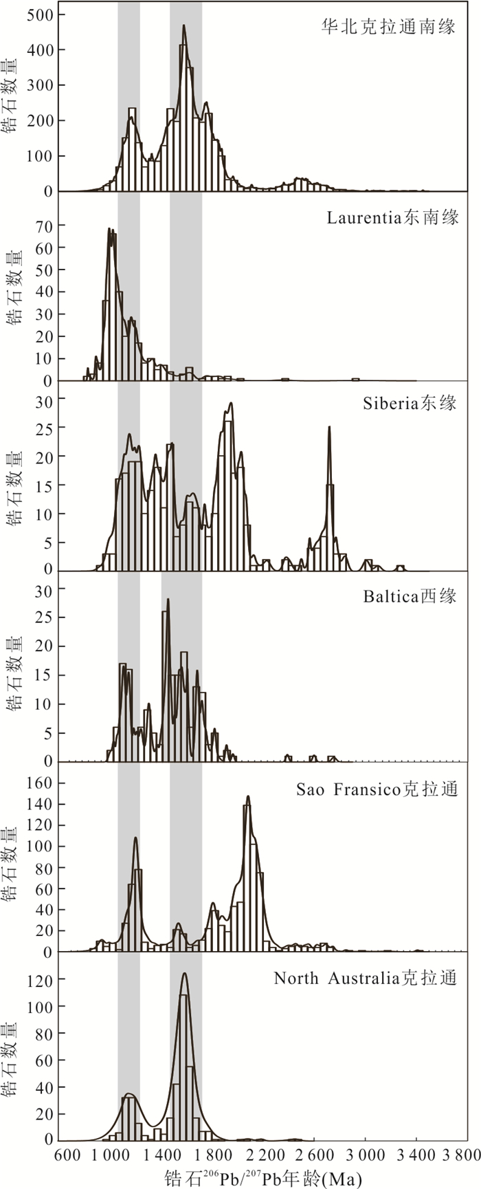
The Penglai Group is an important late Precambrian sedimentary cover in Jiaobei area, which is of great significance to study the late Precambrian evolution in the southeastern margin of the North China Craton. In order to confirm the sedimentary age and provenance characteristics of the Penglai Group in the Jiaobei area, a fine-grained feldspar quartzite in the upper part of the Fuzikuang Formation, Penglai Group in the Qixia area is selected for analyses of the zircon CL image, U-Pb age and REE composition in this study. Results show that detrital zircons mainly belong to magmatic origin, with the peak ages of 1 100 Ma, 1 200 Ma and 1 600 Ma, and there are a few zircons with age older than 1.8 Ga. The youngest zircon age is 1 094±39 Ma, combined with the previous data, the sedimentary age of the Fuzikuang Formation in the Penglai Group should be limited to early Neoproterozoic. The provenance of the Penglai Group in different areas are the same in the middle and upper parts of the Fuzikuang Formation, but the provenance may change in the lower part of the Fuzikuang Formation. From regional perspective, the provenance characteristics of the Penglai Group are similar to those of the Neoproterozoic strata in the southern margin of the North China Craton, such as the Sangwon System in North Korea, and the Xihe Group in the Liaodong Peninsula, the Tumen Group in the Luxi area, the Huainan Group in Xuhuai area and the Luanchuan Group in western Henan, China. The main provenance areas are outside the North China Craton. Combined with paleomagnetic data and distribution of Meso-Neoproterozoic mafic dykes, we speculate that the southern margin of the North China Craton combined with the craton having Grenvillian orogen on it, maybe Laurentia-Siberia-Baltica Craton or Sao Franco-Congo Craton, which provided the provenance for the Penglai Group.
The Penglai Group is an important late Precambrian sedimentary cover in Jiaobei area, which is of great significance to study the late Precambrian evolution in the southeastern margin of the North China Craton. In order to confirm the sedimentary age and provenance characteristics of the Penglai Group in the Jiaobei area, a fine-grained feldspar quartzite in the upper part of the Fuzikuang Formation, Penglai Group in the Qixia area is selected for analyses of the zircon CL image, U-Pb age and REE composition in this study. Results show that detrital zircons mainly belong to magmatic origin, with the peak ages of 1 100 Ma, 1 200 Ma and 1 600 Ma, and there are a few zircons with age older than 1.8 Ga. The youngest zircon age is 1 094±39 Ma, combined with the previous data, the sedimentary age of the Fuzikuang Formation in the Penglai Group should be limited to early Neoproterozoic. The provenance of the Penglai Group in different areas are the same in the middle and upper parts of the Fuzikuang Formation, but the provenance may change in the lower part of the Fuzikuang Formation. From regional perspective, the provenance characteristics of the Penglai Group are similar to those of the Neoproterozoic strata in the southern margin of the North China Craton, such as the Sangwon System in North Korea, and the Xihe Group in the Liaodong Peninsula, the Tumen Group in the Luxi area, the Huainan Group in Xuhuai area and the Luanchuan Group in western Henan, China. The main provenance areas are outside the North China Craton. Combined with paleomagnetic data and distribution of Meso-Neoproterozoic mafic dykes, we speculate that the southern margin of the North China Craton combined with the craton having Grenvillian orogen on it, maybe Laurentia-Siberia-Baltica Craton or Sao Franco-Congo Craton, which provided the provenance for the Penglai Group.


2021, 46(9): 3091-3106.
doi: 10.3799/dqkx.2020.360
Abstract:
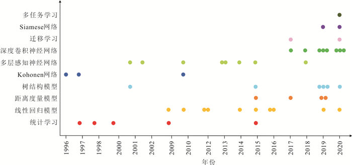
Mineral intelligent identification is a developing interdisciplinary research field between earth science and information science, where machine learning shows great vitality. This paper divides the procedure of mineral intelligent identification into four stages, including mineral collection, data acquisition, model building and category discriminant. Based on the test methods and data types, the mineral intelligent identification can be achieved by three different research routes, namely, chemical-composition-based, microscopic-optical-image-based and spectral-image-based. Various methods of machine learning for mineral intelligent recognition are reviewed in detail including statistical learning, similarity measurement, decision tree, artificial neural network and few new technologies related to testing sample. We suggest that the future directions in this field are to eliminate the gap between geology and artificial intelligence, to build high-quality mineral datasets that can be learned by the machine, to explore and consummate machine learning methods suitable for mineral intelligence identification, to increase the ability of model explanation, and to strengthen the practice of industrial application.
Mineral intelligent identification is a developing interdisciplinary research field between earth science and information science, where machine learning shows great vitality. This paper divides the procedure of mineral intelligent identification into four stages, including mineral collection, data acquisition, model building and category discriminant. Based on the test methods and data types, the mineral intelligent identification can be achieved by three different research routes, namely, chemical-composition-based, microscopic-optical-image-based and spectral-image-based. Various methods of machine learning for mineral intelligent recognition are reviewed in detail including statistical learning, similarity measurement, decision tree, artificial neural network and few new technologies related to testing sample. We suggest that the future directions in this field are to eliminate the gap between geology and artificial intelligence, to build high-quality mineral datasets that can be learned by the machine, to explore and consummate machine learning methods suitable for mineral intelligence identification, to increase the ability of model explanation, and to strengthen the practice of industrial application.

2021, 46(9): 3107-3122.
doi: 10.3799/dqkx.2020.346
Abstract:
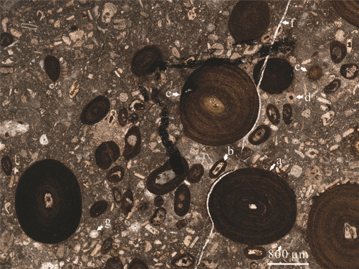
A set of the chamosite-ooidal limestones was discovered at the bottom of the Pagoda Formation (Upper Ordovician) in Xingwen County, Sichuan Province, and its genesis can facilitate the understanding the evolution of the depositional environment in the southwestern Yangtze platform during the same period. Based on a detailed sedimentological analysis, this paper presents a study on the genesis of the chamosite-ooidal limestones, combined with mineralogical characterization via electron microprobe and scanning electron microscope studies. It is found that chamosite-rich ooids and peloids are syngenetic sediments, and symbiotic bioclastic assemblages indicate that the seawater was oxidizing. The abundant microbial-related fabric indicates that microbial mats develop during the same period, and their metabolic activities can lead to the formation of reducing water bodies near the water-sediment interface, which is a necessary condition for the formation of syngenetic chamosite. The Fe and Al elements needed for chamosite formation are derived from large-scale inputs of the early weathering crust during the transgression stage. The chamosite-ooidal limestones at the bottom of the Pagoda Formation are the concrete manifestation of global sea-level evolution in the Yangtze platform at same time. It is an important indicator of sea level fall in the Early Sandbian and rapid transgression in the Late Sandbian in the Yangtze platform.
A set of the chamosite-ooidal limestones was discovered at the bottom of the Pagoda Formation (Upper Ordovician) in Xingwen County, Sichuan Province, and its genesis can facilitate the understanding the evolution of the depositional environment in the southwestern Yangtze platform during the same period. Based on a detailed sedimentological analysis, this paper presents a study on the genesis of the chamosite-ooidal limestones, combined with mineralogical characterization via electron microprobe and scanning electron microscope studies. It is found that chamosite-rich ooids and peloids are syngenetic sediments, and symbiotic bioclastic assemblages indicate that the seawater was oxidizing. The abundant microbial-related fabric indicates that microbial mats develop during the same period, and their metabolic activities can lead to the formation of reducing water bodies near the water-sediment interface, which is a necessary condition for the formation of syngenetic chamosite. The Fe and Al elements needed for chamosite formation are derived from large-scale inputs of the early weathering crust during the transgression stage. The chamosite-ooidal limestones at the bottom of the Pagoda Formation are the concrete manifestation of global sea-level evolution in the Yangtze platform at same time. It is an important indicator of sea level fall in the Early Sandbian and rapid transgression in the Late Sandbian in the Yangtze platform.


2021, 46(9): 3123-3138.
doi: 10.3799/dqkx.2020.396
Abstract:
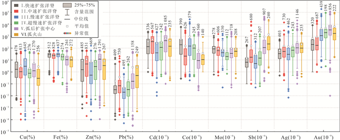
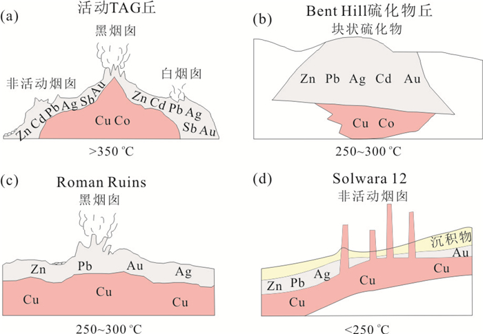
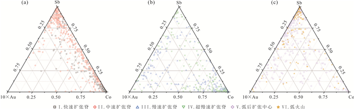
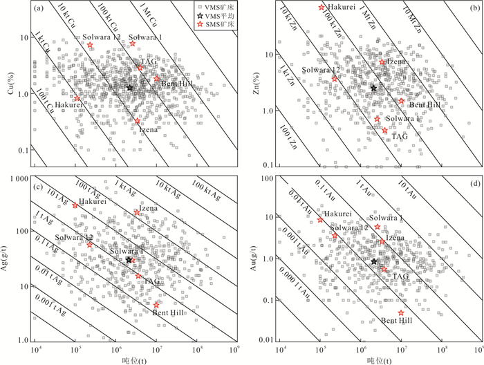
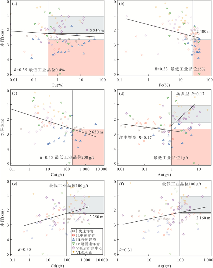
Seafloor massive sulfides (SMS), which are rich in strategic metals such as Cu, Cd, Au, Fe, Ag, and Co, are strategic resources available for human development and utilization in the future. We collected the geochemical composition data of 3 946 SMS samples in global hydrothermal systems. They were classified into six types according to the tectonic setting: fast-spreading ridge type, medium-spreading ridge type, slow-spreading ridge type, ultra-slow spreading ridge type, back-arc spreading center type, and arc volcano type, respectively. The distribution and main controlling factors of SMS strategic metals are analyzed by multivariate statistical method, and then the resource prospects of SMS strategic metals are discussed. It is found that the strategic metals in SMS deposits of different tectonic environments are quite different. The SMS deposits at mid-ocean ridge tend to be enriched in Cu+Fe+Co±Mo, while the SMS deposits in the back-arc spreading center and arc volcano tend to be enriched in Zn+Pb+Cd+Sb+Ag±Au. The main controlling factors of SMS strategic metals are metallogenic temperature, ore-forming source, pH and redox conditions, respectively. The fluid temperature is mainly controlled by the water depth. The sources of ore-forming materials are mainly controlled by the structural geological environment. The pH and redox properties are mainly controlled by the type of wall rock. We propose that the back-arc spreading center with water depth of 1 080-2 160 m could be key targets for strategic metals such as Cu, Au, Cd and Ag, while the regions such as non-transform discontinuous and detachment fault extensional shear zone of slow- and ultraslow-spreading ridges with water depth greater than 2 650 m could be key targets for Cu, Au, Fe, Co, etc.
Seafloor massive sulfides (SMS), which are rich in strategic metals such as Cu, Cd, Au, Fe, Ag, and Co, are strategic resources available for human development and utilization in the future. We collected the geochemical composition data of 3 946 SMS samples in global hydrothermal systems. They were classified into six types according to the tectonic setting: fast-spreading ridge type, medium-spreading ridge type, slow-spreading ridge type, ultra-slow spreading ridge type, back-arc spreading center type, and arc volcano type, respectively. The distribution and main controlling factors of SMS strategic metals are analyzed by multivariate statistical method, and then the resource prospects of SMS strategic metals are discussed. It is found that the strategic metals in SMS deposits of different tectonic environments are quite different. The SMS deposits at mid-ocean ridge tend to be enriched in Cu+Fe+Co±Mo, while the SMS deposits in the back-arc spreading center and arc volcano tend to be enriched in Zn+Pb+Cd+Sb+Ag±Au. The main controlling factors of SMS strategic metals are metallogenic temperature, ore-forming source, pH and redox conditions, respectively. The fluid temperature is mainly controlled by the water depth. The sources of ore-forming materials are mainly controlled by the structural geological environment. The pH and redox properties are mainly controlled by the type of wall rock. We propose that the back-arc spreading center with water depth of 1 080-2 160 m could be key targets for strategic metals such as Cu, Au, Cd and Ag, while the regions such as non-transform discontinuous and detachment fault extensional shear zone of slow- and ultraslow-spreading ridges with water depth greater than 2 650 m could be key targets for Cu, Au, Fe, Co, etc.


2021, 46(9): 3139-3156.
doi: 10.3799/dqkx.2020.302
Abstract:
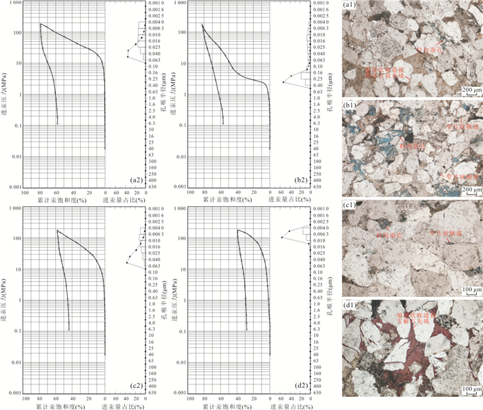
The reservoir of Xujiahe Formation in the Jiannan area of East Sichuan basin is highly heterogeneous and the densification is extremely high. To clarify the process and the controlling factors of reservoir differential evolution, a variety of experimental methods of petrology and petrogeochemistry are used in this study. Based on the detailed description for petrology characteristics of the reservoir, the diagenetic facies are classified; then the rock properties and pore structures are characterized, and finally the reservoir differential evolution process is investigated. Sandstones in study area can be divided into four diagenetic facies, namely, tight compaction facies, dissolution facies, siliceous cementation facies and tight calcite cementation facies. Sandstones from dissolution facies have the best rock properties, followed by the tight compaction sandstone. Siliceous cementation sandstone and calcite cementation sandstone are highly densified with the poorest rock properties. The variations of detrital component are the key factors controlling the heterogeneity and differential evolution of the reservoir. The various contents of ductile rock fragments result in the different degrees of compaction and pore reduction in the early diagenetic period, while feldspar and quartz contents affect the dissolution and calcite cementation degree, and the siliceous cementation degree, respectively. Finally, the detrital component controls the evolution process of reservoir in a different time order, and results in the spatial heterogeneity for the distribution.
The reservoir of Xujiahe Formation in the Jiannan area of East Sichuan basin is highly heterogeneous and the densification is extremely high. To clarify the process and the controlling factors of reservoir differential evolution, a variety of experimental methods of petrology and petrogeochemistry are used in this study. Based on the detailed description for petrology characteristics of the reservoir, the diagenetic facies are classified; then the rock properties and pore structures are characterized, and finally the reservoir differential evolution process is investigated. Sandstones in study area can be divided into four diagenetic facies, namely, tight compaction facies, dissolution facies, siliceous cementation facies and tight calcite cementation facies. Sandstones from dissolution facies have the best rock properties, followed by the tight compaction sandstone. Siliceous cementation sandstone and calcite cementation sandstone are highly densified with the poorest rock properties. The variations of detrital component are the key factors controlling the heterogeneity and differential evolution of the reservoir. The various contents of ductile rock fragments result in the different degrees of compaction and pore reduction in the early diagenetic period, while feldspar and quartz contents affect the dissolution and calcite cementation degree, and the siliceous cementation degree, respectively. Finally, the detrital component controls the evolution process of reservoir in a different time order, and results in the spatial heterogeneity for the distribution.


2021, 46(9): 3157-3171.
doi: 10.3799/dqkx.2020.344
Abstract:
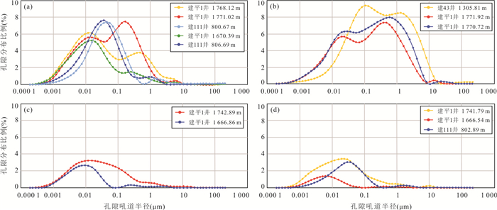
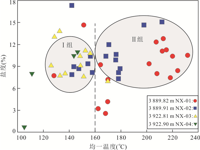
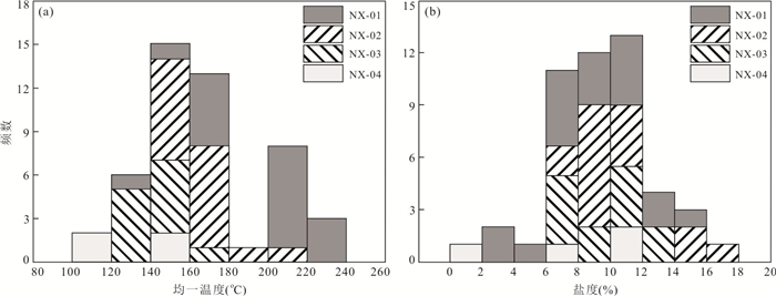
As a key exploration area for Silurian shale gas in southern Sichuan basin, Ningxi area experienced multiple fracture activities. Calcite veins are generally developed in the Longmaxi Member I. At the same time, graphitization occurs due to the extremely high degree of thermal evolution, resulting in shale gas enrichment pattern which remains unknown. This paper presents an estimation of paleotemperatures and paleopressures of the key exploration well in the region-the Well Ningxi 202 of Longmaxi Member I, through integrated analyses on systematic core description, thin section microscopic observation, cathodoluminescence observation, laser Raman spectroscopy, and microscopic temperature measurement. Results show that: High-angle calcite veins (type A) are distributed in the main body of the Longmaxi Member I, and bedding veins (type B) are locally developed. Methane inclusions are mainly developed in Type A veins, and some samples show special bitumen inclusions. The RmcRo of bitumen in bitumen inclusions are 3.52%-4.16%, indicating that they are in the overmature to graphitization. The methane Raman scattering peak is between 2 910.711 2-2 912.495 1 cm-1, with the homogenization temperature between -99.8 to -96.3℃. The density obtained by Raman parameter displacement and microscopic temperature measurement ranged from 0.253 6-0.344 5 g/cm3 and 0.291 6-0.303 2 g/cm3, showing typical high-density characteristics. In conclusion, the high density methane inclusions may be trapped in the early stage of Yanshan tectonic movement and in overpressure state, indicating that the shale system has good sealing property and is conducive to shale gas enrichment.
As a key exploration area for Silurian shale gas in southern Sichuan basin, Ningxi area experienced multiple fracture activities. Calcite veins are generally developed in the Longmaxi Member I. At the same time, graphitization occurs due to the extremely high degree of thermal evolution, resulting in shale gas enrichment pattern which remains unknown. This paper presents an estimation of paleotemperatures and paleopressures of the key exploration well in the region-the Well Ningxi 202 of Longmaxi Member I, through integrated analyses on systematic core description, thin section microscopic observation, cathodoluminescence observation, laser Raman spectroscopy, and microscopic temperature measurement. Results show that: High-angle calcite veins (type A) are distributed in the main body of the Longmaxi Member I, and bedding veins (type B) are locally developed. Methane inclusions are mainly developed in Type A veins, and some samples show special bitumen inclusions. The RmcRo of bitumen in bitumen inclusions are 3.52%-4.16%, indicating that they are in the overmature to graphitization. The methane Raman scattering peak is between 2 910.711 2-2 912.495 1 cm-1, with the homogenization temperature between -99.8 to -96.3℃. The density obtained by Raman parameter displacement and microscopic temperature measurement ranged from 0.253 6-0.344 5 g/cm3 and 0.291 6-0.303 2 g/cm3, showing typical high-density characteristics. In conclusion, the high density methane inclusions may be trapped in the early stage of Yanshan tectonic movement and in overpressure state, indicating that the shale system has good sealing property and is conducive to shale gas enrichment.


2021, 46(9): 3172-3188.
doi: 10.3799/dqkx.2020.354
Abstract:
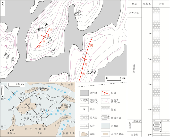
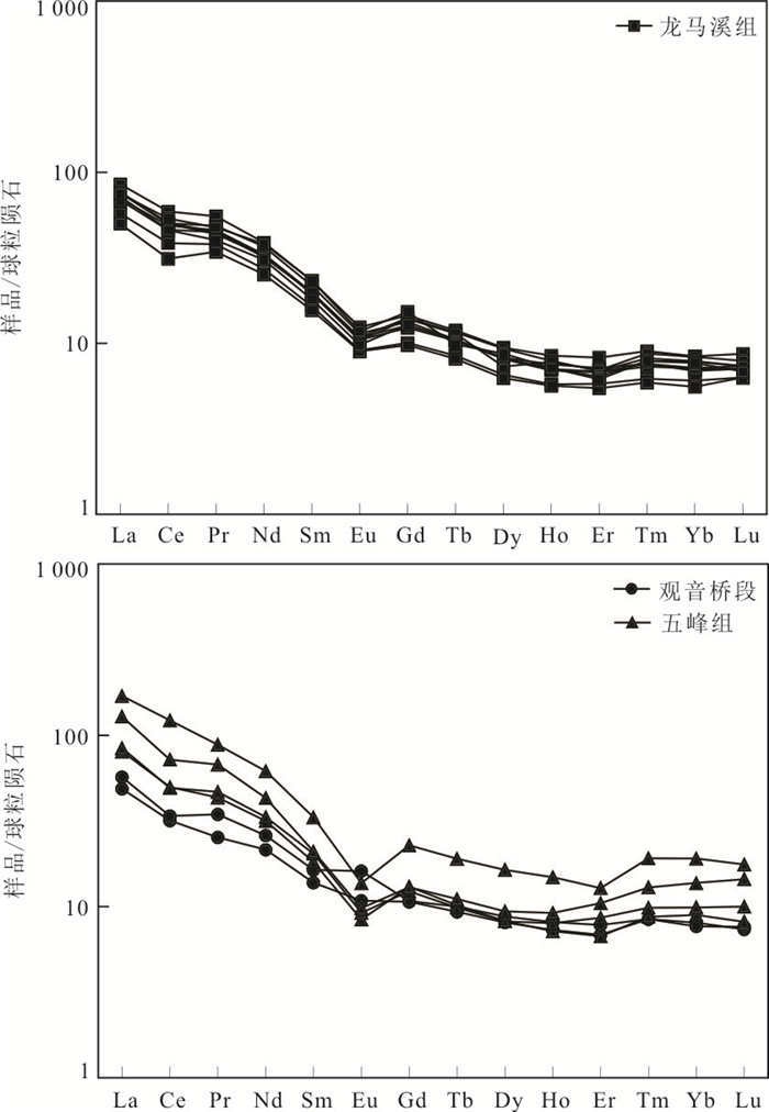
In order to discuss depositional setting and its tectonic background of the Wufeng-Longmaxi Formation organic-rich shales in the northern margin of the central Guizhou uplift, the TOC content, trace elements and rare earth elements of the samples from two wells in the area were tested. The results show that the Wufeng-Longmaxi Formation shales in the study area was mainly deposited in poor oxygen-anaerobic environment, and the oxygen-rich environment also exists occasionally, and the reduction degree of sedimentary water in Longmaxi Formation is higher than that in Wufeng Formation. The sedimentation rate reflected by the changes of LaN/YbN value is as follows: the lower part of the Longmaxi Formation < the Wufeng Formation < the Guanyinqiao section, which reflects the process that the sedimentation rate of the Wufeng-Longmaxi Formation shale becomes faster at first and then slows down. The Mo/TOC values show that the water mass restriction degree of the basin is strong during the sedimentation of the Wufeng Formation shale, and relatively weakened in the Silurian, the restriction degree has little positive effect on the enrichment of organic matter, while the changes of redox conditions and productivity factors caused by sea level rise and fall control the enrichment of organic matter. The characteristics of the trace elements and rare earth elements reflect that the provenance of the Wufeng-Longmaxi Formation shales comes from the upper crust, there is mixed provenance in Wufeng Formation, and the provenance of Longmaxi Formation is relatively simple, generally speaking, the source rocks are mainly feldspathic-quartz (granite). The tectonic setting was mainly passive continental margin, due to the effect of certain hydrothermal input, it also exhibits certain characteristics of continental island arc tectonic background.
In order to discuss depositional setting and its tectonic background of the Wufeng-Longmaxi Formation organic-rich shales in the northern margin of the central Guizhou uplift, the TOC content, trace elements and rare earth elements of the samples from two wells in the area were tested. The results show that the Wufeng-Longmaxi Formation shales in the study area was mainly deposited in poor oxygen-anaerobic environment, and the oxygen-rich environment also exists occasionally, and the reduction degree of sedimentary water in Longmaxi Formation is higher than that in Wufeng Formation. The sedimentation rate reflected by the changes of LaN/YbN value is as follows: the lower part of the Longmaxi Formation < the Wufeng Formation < the Guanyinqiao section, which reflects the process that the sedimentation rate of the Wufeng-Longmaxi Formation shale becomes faster at first and then slows down. The Mo/TOC values show that the water mass restriction degree of the basin is strong during the sedimentation of the Wufeng Formation shale, and relatively weakened in the Silurian, the restriction degree has little positive effect on the enrichment of organic matter, while the changes of redox conditions and productivity factors caused by sea level rise and fall control the enrichment of organic matter. The characteristics of the trace elements and rare earth elements reflect that the provenance of the Wufeng-Longmaxi Formation shales comes from the upper crust, there is mixed provenance in Wufeng Formation, and the provenance of Longmaxi Formation is relatively simple, generally speaking, the source rocks are mainly feldspathic-quartz (granite). The tectonic setting was mainly passive continental margin, due to the effect of certain hydrothermal input, it also exhibits certain characteristics of continental island arc tectonic background.


2021, 46(9): 3189-3202.
doi: 10.3799/dqkx.2020.331
Abstract:
Bozhong 29-6 oilfield is located in the northern steep slope zone of Huanghekou sag, which has a favorable position for hydrocarbon supply from double depressions. It has been found that the crude oil is characterized by thickened oil as a whole, and the characteristics of biomarkers are complex and diverse, and the source of oil-gas and the genetic mechanism of thickened oil are not clear. Based on previous studies and crude oil analysis, by using geochemical analysis method, the source and thickening mechanism of heavy oil in Bozhong 29-6 oilfield are clarified, and the thickening model and reservoiring model are established. The results show that (1) Bozhong 29-6 oilfield has the characteristics of double-depression mixed hydrocarbon supply. The high sulfur-oil mainly derives from the eastern depression of the Huanghekou sag, while the low sulfur-oil mainly derives from the middle depression of the Huanghekou sag; (2) Bozhong 29-6 oilfield group is of shallow heavy oil, and its crude oil properties are controlled by the combination of three factors, namely, secondary filling, fault activity and parent source characteristics. The properties of crude oil are controlled by the combination of three factors which are secondary charge, fault activity and maternal characteristics. Based on three factors, four oil thickening modes are identified, including immature-weak faulting-weak secondary charge, mature-strong faulting-weak secondary charge, mature-strong faulting-strong secondary charge, immature-strong faulting-strong secondary charge. (3) Bozhong 29-6 oilfield has double depression hydrocarbon supply and accumulation mode, which varies with the distance to the sag. Single depression hydrocarbon supply vertical transportation fault strong filling strong degradation heavy oil reservoir forming mode is formed near source, and double depression hydrocarbon supply sand body or unconformity lateral transportation weak filling strong/weak degradation heavy oil accumulation mode is formed at far source; the hydrocarbon supply from single depression near the source, vertical transportation of fault, strong/weak filling, strong degradation, and heavy oil accumulation mode above the source are formed, and the hydrocarbon supply sand body in double depression or unconformity lateral transportation weak filling strong/weak degradation heavy oil accumulation mode is formed in the far source. (4) The surrounding areas of Bozhong 29-6 oilfield can be divided into four zones: zone I has the best physical properties of crude oil, zone II and IV have the most severe thickening and the worst physical properties, and the crude oil in zone III is in the middle. Because the secondary filling can obviously improve the physical properties of crude oil, the exploration and development of medium light crude oil should select area I and area III.
Bozhong 29-6 oilfield is located in the northern steep slope zone of Huanghekou sag, which has a favorable position for hydrocarbon supply from double depressions. It has been found that the crude oil is characterized by thickened oil as a whole, and the characteristics of biomarkers are complex and diverse, and the source of oil-gas and the genetic mechanism of thickened oil are not clear. Based on previous studies and crude oil analysis, by using geochemical analysis method, the source and thickening mechanism of heavy oil in Bozhong 29-6 oilfield are clarified, and the thickening model and reservoiring model are established. The results show that (1) Bozhong 29-6 oilfield has the characteristics of double-depression mixed hydrocarbon supply. The high sulfur-oil mainly derives from the eastern depression of the Huanghekou sag, while the low sulfur-oil mainly derives from the middle depression of the Huanghekou sag; (2) Bozhong 29-6 oilfield group is of shallow heavy oil, and its crude oil properties are controlled by the combination of three factors, namely, secondary filling, fault activity and parent source characteristics. The properties of crude oil are controlled by the combination of three factors which are secondary charge, fault activity and maternal characteristics. Based on three factors, four oil thickening modes are identified, including immature-weak faulting-weak secondary charge, mature-strong faulting-weak secondary charge, mature-strong faulting-strong secondary charge, immature-strong faulting-strong secondary charge. (3) Bozhong 29-6 oilfield has double depression hydrocarbon supply and accumulation mode, which varies with the distance to the sag. Single depression hydrocarbon supply vertical transportation fault strong filling strong degradation heavy oil reservoir forming mode is formed near source, and double depression hydrocarbon supply sand body or unconformity lateral transportation weak filling strong/weak degradation heavy oil accumulation mode is formed at far source; the hydrocarbon supply from single depression near the source, vertical transportation of fault, strong/weak filling, strong degradation, and heavy oil accumulation mode above the source are formed, and the hydrocarbon supply sand body in double depression or unconformity lateral transportation weak filling strong/weak degradation heavy oil accumulation mode is formed in the far source. (4) The surrounding areas of Bozhong 29-6 oilfield can be divided into four zones: zone I has the best physical properties of crude oil, zone II and IV have the most severe thickening and the worst physical properties, and the crude oil in zone III is in the middle. Because the secondary filling can obviously improve the physical properties of crude oil, the exploration and development of medium light crude oil should select area I and area III.


2021, 46(9): 3203-3216.
doi: 10.3799/dqkx.2020.352
Abstract:
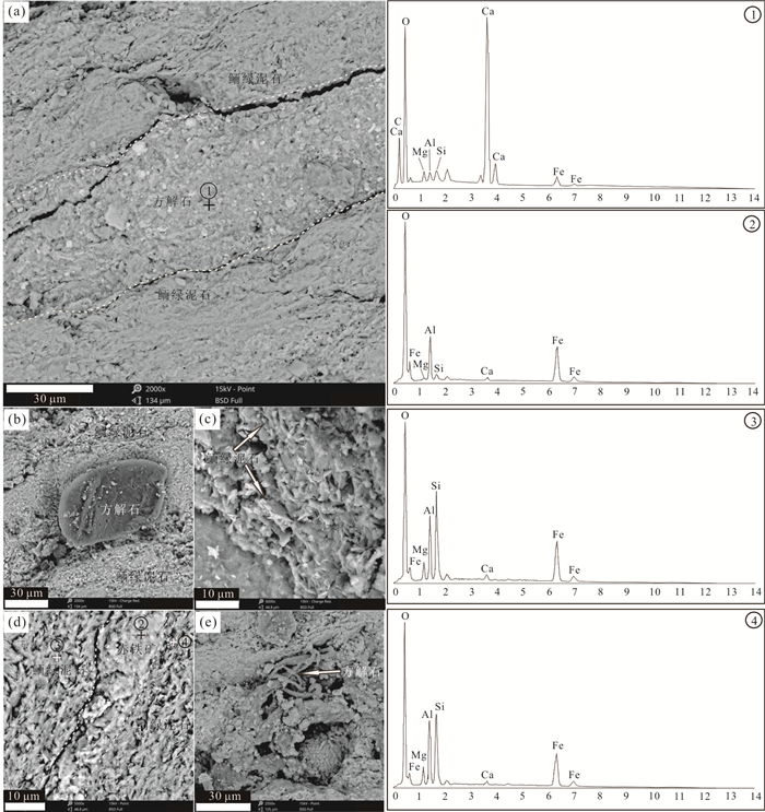
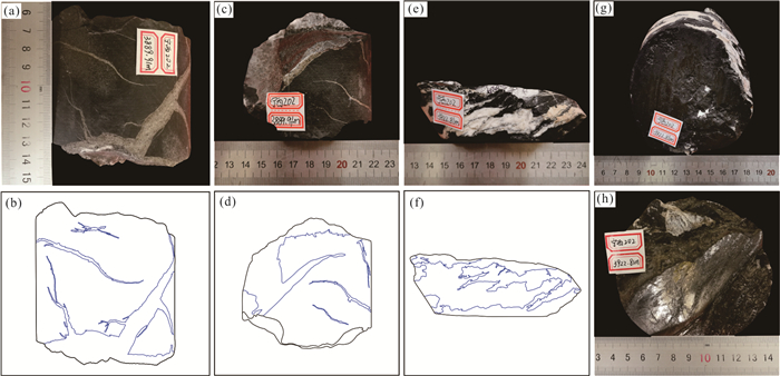
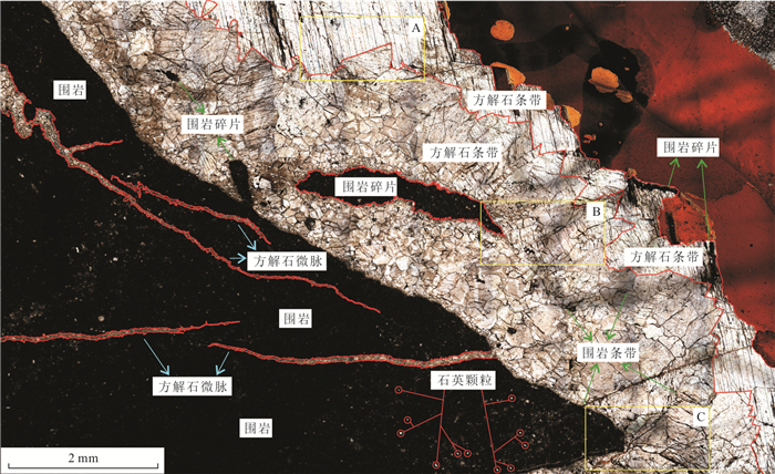
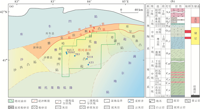
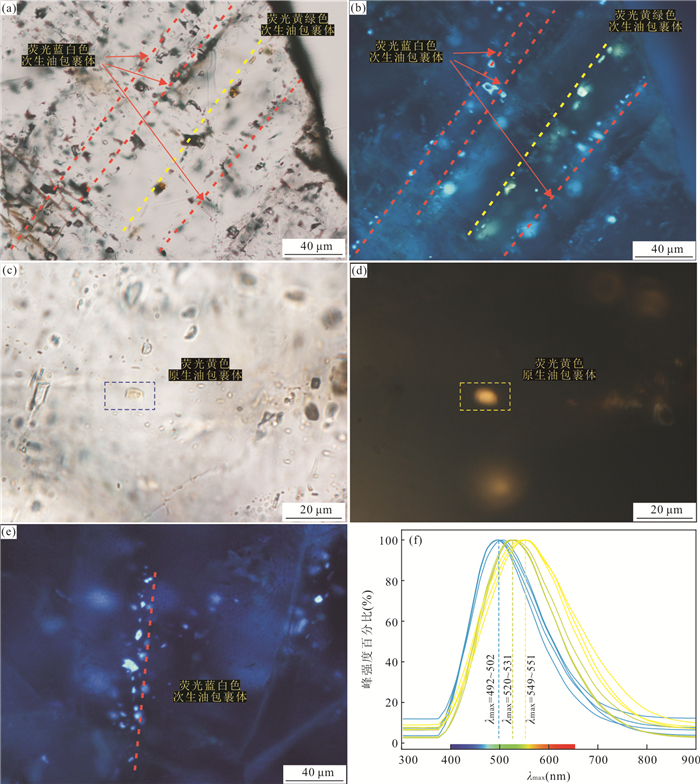
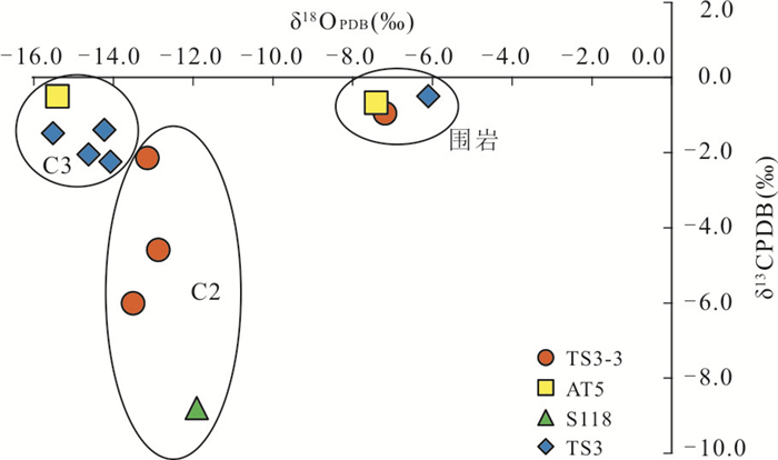
Multiphase calcite veins are developed due to tectonic activities in the carbonate reservoirs of Middle-Lower Ordovician in the Tahe oilfield, which is important for studying the evolution of reservoir fluids and the process of hydrocarbon accumulation. Three phases fracture-filled calcite veins were identified in the carbonate reservoirs of Middle-Lower Ordovician in the Tahe oilfield by core observation, thin section, cathodoluminescence and in-situ element. The three-phase calcite veins have differences in cathodoluminescence color, rare earth elements, strontium, carbon, oxide isotopes and timing of calcite veins generation. The in-situ U-Pb dating by laser ablation yields the absolute ages of the three-phase calcite vein generation of 466±11 Ma to 458.6±8.8 Ma, 329.7±1.6 Ma to 308.1±4.1 Ma and 249.3±2.6 Ma to 220.5±7.3 Ma, respectively. The fluids for second and third phases of calcite vein generation are mainly derived from deep-seated diagenetic fluids with the influence of hydrocarbon-fluids. The fluid of the third phase of calcite vein generation may also be affected by crust-derived strontium, resulting in a higher 87Sr/86Sr ratio than that of the second phase of calcite veins. The absolute ages of calcite veins generation can be used to constrain the fault activity and hydrocarbon charge histories in multi-cycle superimposed basins. The timing of the three phases of calcite veins generation corresponds to the periods of fault activity caused by the Middle Caledonian episode I, the Middle Hercynian episode Ⅰ-Ⅱ, and the Late Hercynian-Indosinian period. The symbiotic relationship between calcite veins and hydrocarbon fluid inclusions indicates that the Middle-Lower Ordovician reservoirs experienced one episode of oil charge episode of the Middle Hercynian episode and two episodes of oil charge after the Indosinian period.
Multiphase calcite veins are developed due to tectonic activities in the carbonate reservoirs of Middle-Lower Ordovician in the Tahe oilfield, which is important for studying the evolution of reservoir fluids and the process of hydrocarbon accumulation. Three phases fracture-filled calcite veins were identified in the carbonate reservoirs of Middle-Lower Ordovician in the Tahe oilfield by core observation, thin section, cathodoluminescence and in-situ element. The three-phase calcite veins have differences in cathodoluminescence color, rare earth elements, strontium, carbon, oxide isotopes and timing of calcite veins generation. The in-situ U-Pb dating by laser ablation yields the absolute ages of the three-phase calcite vein generation of 466±11 Ma to 458.6±8.8 Ma, 329.7±1.6 Ma to 308.1±4.1 Ma and 249.3±2.6 Ma to 220.5±7.3 Ma, respectively. The fluids for second and third phases of calcite vein generation are mainly derived from deep-seated diagenetic fluids with the influence of hydrocarbon-fluids. The fluid of the third phase of calcite vein generation may also be affected by crust-derived strontium, resulting in a higher 87Sr/86Sr ratio than that of the second phase of calcite veins. The absolute ages of calcite veins generation can be used to constrain the fault activity and hydrocarbon charge histories in multi-cycle superimposed basins. The timing of the three phases of calcite veins generation corresponds to the periods of fault activity caused by the Middle Caledonian episode I, the Middle Hercynian episode Ⅰ-Ⅱ, and the Late Hercynian-Indosinian period. The symbiotic relationship between calcite veins and hydrocarbon fluid inclusions indicates that the Middle-Lower Ordovician reservoirs experienced one episode of oil charge episode of the Middle Hercynian episode and two episodes of oil charge after the Indosinian period.


2021, 46(9): 3217-3229.
doi: 10.3799/dqkx.2020.359
Abstract:
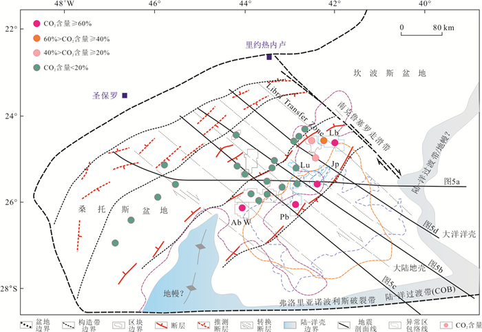
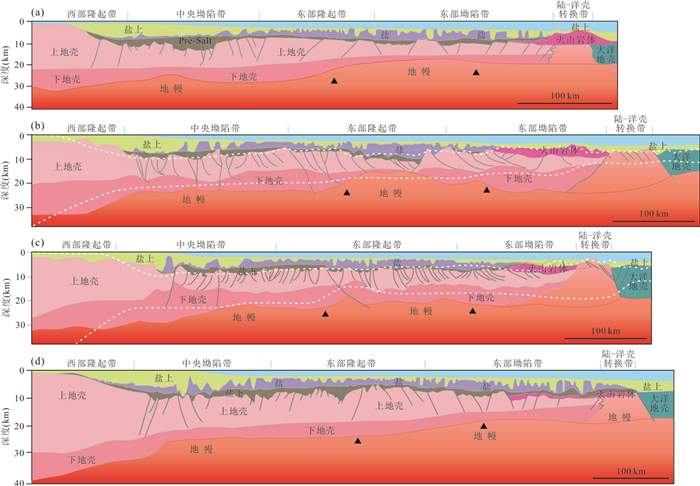
An extraordinarily high amount of CO2found in pre-salt section in Santos basin poses great challenges to the oil and gas exploration and development. In this study, combining regional gravity and magnetic database, deep-seismic lines, well drilling, formation test and samples dataset of the basin, the origin of CO2 was clarified firstly, and its regional distribution patterns were statistically analyzed and their main controlling factors were explored as well. The widely distributed CO2 in pre-salt reservoirs in Santos basin is mainly sourced from mantle, and mantle-derived CO2 contributes at least 92% of the total volume of CO2. Regionally, CO2 abundance gradually increases from continent to ocean, and is relatively concentrated in the eastern uplift of the basin. On its margin usually occurs the current maximum CO2 content values. The extra-high CO2 abundance in Santos basin is the result of the combined action of various geological factors such as crust & mantle transition, regional tectonic evolution, magma events and fault activity. Among them, continental crust thinning and mantle uplifting are the most important background factors, controlling the regional distribution of CO2. The intensive extension of crust caused a strong stretching and thinning of the lower continental crust of Sao Paulo platform, forming a crustal thinning area, around 5.1×10⁴ km2, which caused the CO2-rich mantle material to intrude upward into the continental crust. This uplifted mantle has directly controlled the regional distribution of CO2 in Santos basin. Outside this area, the risk of CO2 is significantly reduced. Magma injection or active faults are both important pathways for CO2 migration and accumulation, with most common cases involving active faults leading CO2 from "uplifted" mantle to shallower reservoirs. The NW-SE strike-slip faults and the NE-SW class I-II normal faults have an obvious control effect on distribution of CO2 in shallower formation: NW-SE strike-slip fault could extend into deep mantle, while the NE-SW normal faults distribute these CO2 in shallower layers. So that their intersection points or periphery areas are the most favorable areas for accumulation of magma and CO2.
An extraordinarily high amount of CO2found in pre-salt section in Santos basin poses great challenges to the oil and gas exploration and development. In this study, combining regional gravity and magnetic database, deep-seismic lines, well drilling, formation test and samples dataset of the basin, the origin of CO2 was clarified firstly, and its regional distribution patterns were statistically analyzed and their main controlling factors were explored as well. The widely distributed CO2 in pre-salt reservoirs in Santos basin is mainly sourced from mantle, and mantle-derived CO2 contributes at least 92% of the total volume of CO2. Regionally, CO2 abundance gradually increases from continent to ocean, and is relatively concentrated in the eastern uplift of the basin. On its margin usually occurs the current maximum CO2 content values. The extra-high CO2 abundance in Santos basin is the result of the combined action of various geological factors such as crust & mantle transition, regional tectonic evolution, magma events and fault activity. Among them, continental crust thinning and mantle uplifting are the most important background factors, controlling the regional distribution of CO2. The intensive extension of crust caused a strong stretching and thinning of the lower continental crust of Sao Paulo platform, forming a crustal thinning area, around 5.1×10⁴ km2, which caused the CO2-rich mantle material to intrude upward into the continental crust. This uplifted mantle has directly controlled the regional distribution of CO2 in Santos basin. Outside this area, the risk of CO2 is significantly reduced. Magma injection or active faults are both important pathways for CO2 migration and accumulation, with most common cases involving active faults leading CO2 from "uplifted" mantle to shallower reservoirs. The NW-SE strike-slip faults and the NE-SW class I-II normal faults have an obvious control effect on distribution of CO2 in shallower formation: NW-SE strike-slip fault could extend into deep mantle, while the NE-SW normal faults distribute these CO2 in shallower layers. So that their intersection points or periphery areas are the most favorable areas for accumulation of magma and CO2.


2021, 46(9): 3230-3244.
doi: 10.3799/dqkx.2020.334
Abstract:
The thick loess-palaeosol sequences in the Jiaodong Peninsula and Central Shandong mountains provide high-resolution records of Late Quaternary climate change of the Shandong Province. However, it is still controversial as to where they came from. This study presents systematically the detrital zircon U-Pb age (n=420) and multi-dimensional discrimination diagram results of statistical method. It is shown that the North China Plain and Bohai shelf material served as a major dust supply for the loess in the Jiaodong Peninsula and eastern parts of the Central Shandong mountains during the Late Pleistocene. By contrast, the major dust source for the loess in the western parts of the Central Shandong mountains is mainly derived from the sediments exposed on the floodplain of the lower reaches of the Yellow River and the Loess Plateau during the Late Pleistocene. They have no provenance relationship with the sediments exposed on the sea floor in the Bohai Sea at the same time.
The thick loess-palaeosol sequences in the Jiaodong Peninsula and Central Shandong mountains provide high-resolution records of Late Quaternary climate change of the Shandong Province. However, it is still controversial as to where they came from. This study presents systematically the detrital zircon U-Pb age (n=420) and multi-dimensional discrimination diagram results of statistical method. It is shown that the North China Plain and Bohai shelf material served as a major dust supply for the loess in the Jiaodong Peninsula and eastern parts of the Central Shandong mountains during the Late Pleistocene. By contrast, the major dust source for the loess in the western parts of the Central Shandong mountains is mainly derived from the sediments exposed on the floodplain of the lower reaches of the Yellow River and the Loess Plateau during the Late Pleistocene. They have no provenance relationship with the sediments exposed on the sea floor in the Bohai Sea at the same time.


2021, 46(9): 3245-3257.
doi: 10.3799/dqkx.2020.357
Abstract:
The study of sedimentary facies and characteristics contributes to a more comprehensive understanding of river and lake environmental evolution, but there are no description of such studies in the Zi River delta, Dongting basin. Based on the Quaternary sedimentary samples of typical borehole (BMS01 and BMS02), and combined with the petrology, chronology and sedimentology study, this study uses particle size frequency distribution curves for the discriminant analysis of sedimentary facies of Quaternary deposits in the studied area. Grain size parameters of the calculation results and the Fisher discriminant model were used for verification. The results show that the Fisher model is suitable for the identification of fluvial facies, lacustrine facies and unstable facies in plain area. In the application of the discriminant function in the study area, the overall recognition accuracy rate of the discriminant function was 94.9%, and the misjudgment rate was 5.1%, which was higher than the general standard of 75% accuracy. Based on the comprehensive identification results and geological research data, this paper expounds the regional polycyclic sedimentary characteristics and evolution process since the Quaternary by using C-M diagram and particle size scatter diagram, and explains the formation mechanism of the strata. The research results could provide basic data for the classification and correlation of Quaternary strata, the evaluation of groundwater resources and the study of natural and inferior groundwater.
The study of sedimentary facies and characteristics contributes to a more comprehensive understanding of river and lake environmental evolution, but there are no description of such studies in the Zi River delta, Dongting basin. Based on the Quaternary sedimentary samples of typical borehole (BMS01 and BMS02), and combined with the petrology, chronology and sedimentology study, this study uses particle size frequency distribution curves for the discriminant analysis of sedimentary facies of Quaternary deposits in the studied area. Grain size parameters of the calculation results and the Fisher discriminant model were used for verification. The results show that the Fisher model is suitable for the identification of fluvial facies, lacustrine facies and unstable facies in plain area. In the application of the discriminant function in the study area, the overall recognition accuracy rate of the discriminant function was 94.9%, and the misjudgment rate was 5.1%, which was higher than the general standard of 75% accuracy. Based on the comprehensive identification results and geological research data, this paper expounds the regional polycyclic sedimentary characteristics and evolution process since the Quaternary by using C-M diagram and particle size scatter diagram, and explains the formation mechanism of the strata. The research results could provide basic data for the classification and correlation of Quaternary strata, the evaluation of groundwater resources and the study of natural and inferior groundwater.


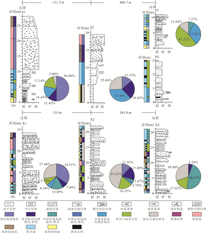
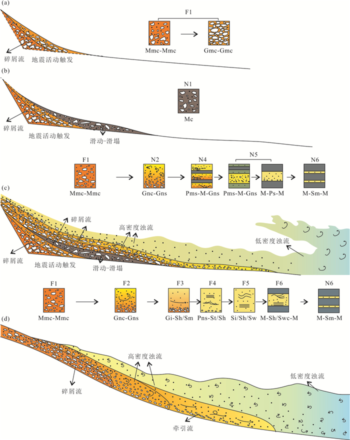
2021, 46(9): 3258-3277.
doi: 10.3799/dqkx.2020.355
Abstract:
In order to investigate the sedimentary characteristics,transport mechanism and evolution of the subaqueous coarse clastic rocks under the control of tectonic activity,this paper takes the Cretaceous Xiguayuan Formation in the Luanping rift basin as the study example. Technical methods,including UAV oblique photography,measured section,quantitative characterization of gravel orientation,and field outcrop anatomy were carried out from the sedimentary background,lithofacies,sedimentary units and facies association characteristics. During the Xiguayuan Formation of Luanping basin,the subaqueous fan developed in environments with high tectonic subsidence rates,rising lake level,deep water and steep palaeogeomorphology. Floods carried coarse clastic deposits along the steep slope into the lake,and its bottom developed gravelly debris flow associated with seismic activity,accompanied by sliding-slip sediments developed. The upper part is mainly composed of high-density turbidity currents. The slope gradient gradually decreases with the continuous supply of coarse clastic rocks. With the increasing transport distance of coarse debris deposits,the gravels in the bottom of gravelly debris flow show directionality and the thickness proportion of high-density turbidity flow increases. The end part is dominated by low-density turbidity flow. The fan deltas developed in environments with relatively low tectonic subsidence rates,relatively shallow water and gentle palaeogeomorphology,and developed a relatively mature sediment delivery system. The catchment system is long,and the coarse clastic rocks transformed from clastic flow into high-density turbidity flow,traction current and low-density turbidity flow.
In order to investigate the sedimentary characteristics,transport mechanism and evolution of the subaqueous coarse clastic rocks under the control of tectonic activity,this paper takes the Cretaceous Xiguayuan Formation in the Luanping rift basin as the study example. Technical methods,including UAV oblique photography,measured section,quantitative characterization of gravel orientation,and field outcrop anatomy were carried out from the sedimentary background,lithofacies,sedimentary units and facies association characteristics. During the Xiguayuan Formation of Luanping basin,the subaqueous fan developed in environments with high tectonic subsidence rates,rising lake level,deep water and steep palaeogeomorphology. Floods carried coarse clastic deposits along the steep slope into the lake,and its bottom developed gravelly debris flow associated with seismic activity,accompanied by sliding-slip sediments developed. The upper part is mainly composed of high-density turbidity currents. The slope gradient gradually decreases with the continuous supply of coarse clastic rocks. With the increasing transport distance of coarse debris deposits,the gravels in the bottom of gravelly debris flow show directionality and the thickness proportion of high-density turbidity flow increases. The end part is dominated by low-density turbidity flow. The fan deltas developed in environments with relatively low tectonic subsidence rates,relatively shallow water and gentle palaeogeomorphology,and developed a relatively mature sediment delivery system. The catchment system is long,and the coarse clastic rocks transformed from clastic flow into high-density turbidity flow,traction current and low-density turbidity flow.


2021, 46(9): 3278-3289.
doi: 10.3799/dqkx.2020.329
Abstract:
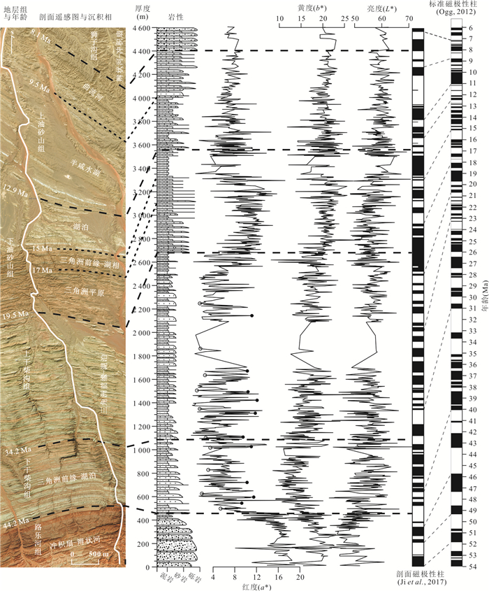
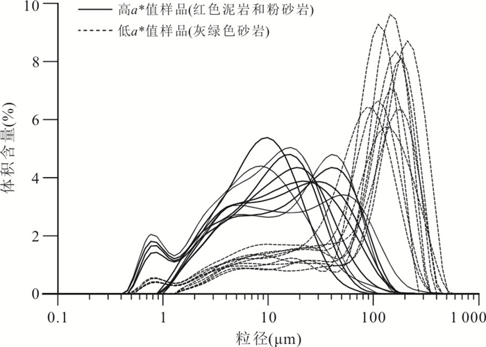
Cenozoic sediments up to 10 000 meters thick in the Qaidam basin recorded the Tibetan plateau uplift and paleoclimate changes. Based on the high-resolution magnetic polarity dating scale of the Dahonggou section in the northern margin of the basin,the color measurement of the Paleo-Neogene fluvial and lacustrine sediments in this section is performed. Furthermore,integrating the sedimentary facies,regional tectonic and paleoclimate records,this paper discusses the factors affecting the color parameters of river-lacustrine sediments and the climate evolution of the Qaidam basin during the Paleo-Neogene period. The research results show that the change of sediment color in Dahonggou section is basically consistent with the global temperature trend,indicating that temperature is the main factor affecting color parameters,especially the redness (a*) value,but the sedimentary facies changes,especially changes in the oxidation-reduction environment above and below the water,also have an important influence on the color parameters. According to the changes of color parameters on the time scale,the climate change in the Qaidam basin has been divided into 8 stages: (a) hot and humid during 52.0-44.2 Ma,(b) gradually becomes dry in the fluctuation of dryness and wetness during 44.2-33.7 Ma,(c) further dries during 33.7-27.1 Ma,(d) gradually becomes wet during 27.1-19.7 Ma,(e) relatively dry during 19.7-17.0 Ma,(f) warm and humid during 17.0-13.3 Ma,(g) rapidly dries during 13.3-9.5 Ma,(h) becomes further arid during 9.5-7.0 Ma. The main factors affecting the Paleo-Neogene climate change in the Qaidam basin include global temperature,the Para-Tethys Sea,the uplift of the Tibetan plateau and the East Asian summer monsoon.
Cenozoic sediments up to 10 000 meters thick in the Qaidam basin recorded the Tibetan plateau uplift and paleoclimate changes. Based on the high-resolution magnetic polarity dating scale of the Dahonggou section in the northern margin of the basin,the color measurement of the Paleo-Neogene fluvial and lacustrine sediments in this section is performed. Furthermore,integrating the sedimentary facies,regional tectonic and paleoclimate records,this paper discusses the factors affecting the color parameters of river-lacustrine sediments and the climate evolution of the Qaidam basin during the Paleo-Neogene period. The research results show that the change of sediment color in Dahonggou section is basically consistent with the global temperature trend,indicating that temperature is the main factor affecting color parameters,especially the redness (a*) value,but the sedimentary facies changes,especially changes in the oxidation-reduction environment above and below the water,also have an important influence on the color parameters. According to the changes of color parameters on the time scale,the climate change in the Qaidam basin has been divided into 8 stages: (a) hot and humid during 52.0-44.2 Ma,(b) gradually becomes dry in the fluctuation of dryness and wetness during 44.2-33.7 Ma,(c) further dries during 33.7-27.1 Ma,(d) gradually becomes wet during 27.1-19.7 Ma,(e) relatively dry during 19.7-17.0 Ma,(f) warm and humid during 17.0-13.3 Ma,(g) rapidly dries during 13.3-9.5 Ma,(h) becomes further arid during 9.5-7.0 Ma. The main factors affecting the Paleo-Neogene climate change in the Qaidam basin include global temperature,the Para-Tethys Sea,the uplift of the Tibetan plateau and the East Asian summer monsoon.


2021, 46(9): 3290-3306.
doi: 10.3799/dqkx.2020.265
Abstract:
The Early Mesozoic tectonic regime transition in South China had a profound impact on the paleoclimate evolution in southern Guangdong,but the study of its internal relationship is still insufficient. In order to understand the response relationship,the mudstone samples collected from Xiaoping Formation,Jinji Formation and Qiaoyuan Formation in South Guangdong in Upper Triassic-Lower-Middle Jurassic were used for the main element analyses by X-ray fluorescence spectrometry,ICP-MS trace and rare earth element tests,combined with the comprehensive analysis of sedimentary and paleontological characteristics. According to the tests,the CIA (75.7-81.3),Sr/Cu (0.83-21.30),Rb/Sr (2.32-12.80),Mg/Ca (0.57-2.50) and Sr/Ba (0.04-0.19) of mudstone samples from Xiaoping Formation in Fenggang indicate that it was in a warm and humid climate in the Early Triassic,and the redox index δCe(0.93-0.95) indicates a weak oxidation environment,indirectly reflecting the warm and humid climate; The CIA (77.5-82.2),Sr/Cu (8.41-13.30),Rb/Sr (2.08-5.83),Mg/Ca (0.79-3.10) and Sr/Ba (0.06-0.26) of mudstone samples from Xiaoping Formation in Ma'an indicate that it was in a hot and dry climate in the Late Triassic,and the redox index δCe(1.04-1.05) indicates a reduction environment,indirectly reflecting the dry and hot climate; The CIA (77.1-82.3),Sr/Cu (1.51-4.38),Rb/Sr (2.16-12.10),Mg/Ca (0.84-2.94) and Sr/Ba (0.04-0.24) of mudstone samples from Jinji and Qiaoyuan formations indicate that the paleoclimate of Early Jurassic-Early-Middle Jurassic was mainly warm and humid,with a brief time of hot and dry climate. And the redox index δCe (0.92-1.00) indicates a weak reduction-weak oxidation environment,indirectly reflecting the paleoclimate was mainly warm and humid,with a brief time of hot and dry climate. Compared with other areas in South China continental margin,the paleoclimate underwent the same change of warm and humid (the early of Late-Triassic)-dry and heat (the late of Late-Triassic)-mainly warm and humid,dry and hot for a brief time (Early Jurassic-Early-Middle Jurassic). This evolution of paleoclimate in South Guangdong from Late Triassic to Early-Middle Jurassic is exactly in response to the transition from Tethys tectonic domain to paleo-Pacific tectonic domain.
The Early Mesozoic tectonic regime transition in South China had a profound impact on the paleoclimate evolution in southern Guangdong,but the study of its internal relationship is still insufficient. In order to understand the response relationship,the mudstone samples collected from Xiaoping Formation,Jinji Formation and Qiaoyuan Formation in South Guangdong in Upper Triassic-Lower-Middle Jurassic were used for the main element analyses by X-ray fluorescence spectrometry,ICP-MS trace and rare earth element tests,combined with the comprehensive analysis of sedimentary and paleontological characteristics. According to the tests,the CIA (75.7-81.3),Sr/Cu (0.83-21.30),Rb/Sr (2.32-12.80),Mg/Ca (0.57-2.50) and Sr/Ba (0.04-0.19) of mudstone samples from Xiaoping Formation in Fenggang indicate that it was in a warm and humid climate in the Early Triassic,and the redox index δCe(0.93-0.95) indicates a weak oxidation environment,indirectly reflecting the warm and humid climate; The CIA (77.5-82.2),Sr/Cu (8.41-13.30),Rb/Sr (2.08-5.83),Mg/Ca (0.79-3.10) and Sr/Ba (0.06-0.26) of mudstone samples from Xiaoping Formation in Ma'an indicate that it was in a hot and dry climate in the Late Triassic,and the redox index δCe(1.04-1.05) indicates a reduction environment,indirectly reflecting the dry and hot climate; The CIA (77.1-82.3),Sr/Cu (1.51-4.38),Rb/Sr (2.16-12.10),Mg/Ca (0.84-2.94) and Sr/Ba (0.04-0.24) of mudstone samples from Jinji and Qiaoyuan formations indicate that the paleoclimate of Early Jurassic-Early-Middle Jurassic was mainly warm and humid,with a brief time of hot and dry climate. And the redox index δCe (0.92-1.00) indicates a weak reduction-weak oxidation environment,indirectly reflecting the paleoclimate was mainly warm and humid,with a brief time of hot and dry climate. Compared with other areas in South China continental margin,the paleoclimate underwent the same change of warm and humid (the early of Late-Triassic)-dry and heat (the late of Late-Triassic)-mainly warm and humid,dry and hot for a brief time (Early Jurassic-Early-Middle Jurassic). This evolution of paleoclimate in South Guangdong from Late Triassic to Early-Middle Jurassic is exactly in response to the transition from Tethys tectonic domain to paleo-Pacific tectonic domain.


2021, 46(9): 3307-3320.
doi: 10.3799/dqkx.2020.343
Abstract:
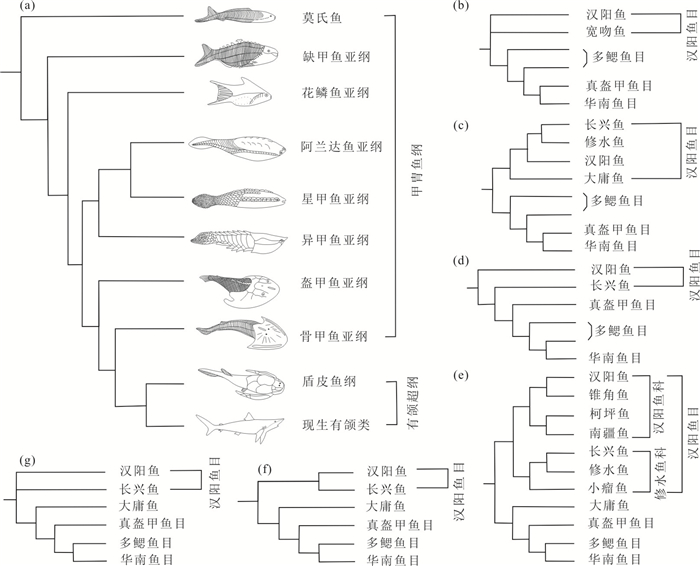
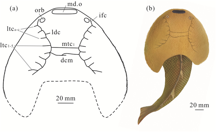
As a representative of the Paleozoic fishes in Wuhan,Hubei Province,Hanyangaspis's true morphology has not been determined,and the phylogenetic relationship within Hanyangaspidida is only discussed in the two genera,without a detailed analysis and discussion. In this paper,morphological and cladistic methods were used to study the new materials of galeaspids. New findings of galeaspids (Agnatha) including Hongshanaspis inexpectatus gen. et sp. nov. and Hanyangaspis guodingshanensis are described from the upper part of the Qingshui Formation (Telychian,Llandovery) in Wuhan of South China. The new genus belongs to Hanyangaspidae based on the trapezoid shape of the head-shield and transverse slit-like median dorsal opening. It differs from other genera and species of Hanyangaspidae by a gradual change from smooth to serrated lateral margin of the head shield,dorsally positioned and oval orbit,8 lateral transverse canals on each side and evenly fine tubercular ornamentation. The cladistics results show that Hanyangaspidida isn't a monophyletic group,but the genera and species of Xiushuiaspidae constitute a monophyletic group. Meanwhile the facies markers of the upper part of the Qingshui Formation imply that Hongshanaspis inexpectatus lived in a deeper tidal delta environment compared with Hanyangaspis guodingshanensis.
As a representative of the Paleozoic fishes in Wuhan,Hubei Province,Hanyangaspis's true morphology has not been determined,and the phylogenetic relationship within Hanyangaspidida is only discussed in the two genera,without a detailed analysis and discussion. In this paper,morphological and cladistic methods were used to study the new materials of galeaspids. New findings of galeaspids (Agnatha) including Hongshanaspis inexpectatus gen. et sp. nov. and Hanyangaspis guodingshanensis are described from the upper part of the Qingshui Formation (Telychian,Llandovery) in Wuhan of South China. The new genus belongs to Hanyangaspidae based on the trapezoid shape of the head-shield and transverse slit-like median dorsal opening. It differs from other genera and species of Hanyangaspidae by a gradual change from smooth to serrated lateral margin of the head shield,dorsally positioned and oval orbit,8 lateral transverse canals on each side and evenly fine tubercular ornamentation. The cladistics results show that Hanyangaspidida isn't a monophyletic group,but the genera and species of Xiushuiaspidae constitute a monophyletic group. Meanwhile the facies markers of the upper part of the Qingshui Formation imply that Hongshanaspis inexpectatus lived in a deeper tidal delta environment compared with Hanyangaspis guodingshanensis.


2021, 46(9): 3321-3337.
doi: 10.3799/dqkx.2021.098
Abstract:
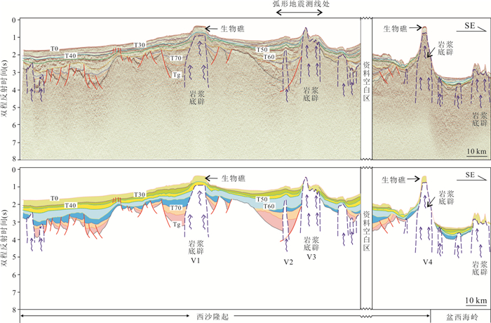
Xisha area is located between the Northwest subbasin and the southwest Subbasin of the South China Sea,whose tectonic evolution is closely related to the oceanic spreading of the South China Sea and the strike-slip movement along the west part of the South China Sea. Together with regional seismic data,we carried out tectono-stratigraphic analysis in the Xisha area. Our study mapped three types of basins,i.e. subbasins controlled by high-angle faults,low-angle detachment faults and strike-slip faults,respectively. The lithospheric crust thickness varied a lot here indicating the different crust thinning across the region. We divided the Xisha area into four tectonic domains,i.e. the northern domain with detachment fault system,the southeastern domain with detachment fault system,the western domain with strike-slip fault system,and central domain with high angle fault system. Our results will improve our understanding on the tectonic evolution in Xisha area,with implications for petroleum exploration there.
Xisha area is located between the Northwest subbasin and the southwest Subbasin of the South China Sea,whose tectonic evolution is closely related to the oceanic spreading of the South China Sea and the strike-slip movement along the west part of the South China Sea. Together with regional seismic data,we carried out tectono-stratigraphic analysis in the Xisha area. Our study mapped three types of basins,i.e. subbasins controlled by high-angle faults,low-angle detachment faults and strike-slip faults,respectively. The lithospheric crust thickness varied a lot here indicating the different crust thinning across the region. We divided the Xisha area into four tectonic domains,i.e. the northern domain with detachment fault system,the southeastern domain with detachment fault system,the western domain with strike-slip fault system,and central domain with high angle fault system. Our results will improve our understanding on the tectonic evolution in Xisha area,with implications for petroleum exploration there.


2021, 46(9): 3338-3351.
doi: 10.3799/dqkx.2021.064
Abstract:
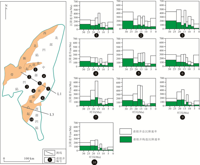
The Wan'an basin is one of the most important sedimentary basins in the southwestern South China Sea. Based on 2D seismic data covering the whole basin,combined with the latest research results,this study analyzes the characteristics of tectonic-sequence and evolution of tectonics-sedimentary infillings of the Wan'an basin. In this study,8 major 2nd and 3rd order sequence boundaries have been identified in the Wan'an basin. Further subsidence simulation shows that the overall feature of subsidence rate of the basin shows a "high-low-high" process,with rough characteristics of higher in the east and lower in the west,higher in the north and lower in the south. Combined tectonic-sequences and simulation results of subsidence,evolution of tectonic-sedimentary infillings of Wan'an basin since Cenozoic can be divided into five stages,which are early rifting stage,late rifting stage,rifting-post rifting transitional stage,thermal subsidence stage and accelerated thermal subsidence stage. Since the formation of the basin,the subsidence has mainly been affected by the deep faults caused by the extension of the East Asian continental margin. In Pliocene,the Wan'an fault became the main influencing factor of the basin subsidence,which resulted in the early migration of the basin subsidence center from the middle to the west,and then gradually to the east. From Oligocene to Early Miocene,the basin was in rifting stage,which was dominated by terrigenous clastic deposits. In Middle Miocene,the basin was in rifting-post rifting transitional stage and thermal subsidence has begun since Late Miocene. In these two stages,except for clastic deposits,carbonate deposits were also developed. In addition,compared to transitional stage,carbonate deposits in the thermal subsidence stage were relatively reduced,and the terrigenous clastic deposits were relatively expanded.
The Wan'an basin is one of the most important sedimentary basins in the southwestern South China Sea. Based on 2D seismic data covering the whole basin,combined with the latest research results,this study analyzes the characteristics of tectonic-sequence and evolution of tectonics-sedimentary infillings of the Wan'an basin. In this study,8 major 2nd and 3rd order sequence boundaries have been identified in the Wan'an basin. Further subsidence simulation shows that the overall feature of subsidence rate of the basin shows a "high-low-high" process,with rough characteristics of higher in the east and lower in the west,higher in the north and lower in the south. Combined tectonic-sequences and simulation results of subsidence,evolution of tectonic-sedimentary infillings of Wan'an basin since Cenozoic can be divided into five stages,which are early rifting stage,late rifting stage,rifting-post rifting transitional stage,thermal subsidence stage and accelerated thermal subsidence stage. Since the formation of the basin,the subsidence has mainly been affected by the deep faults caused by the extension of the East Asian continental margin. In Pliocene,the Wan'an fault became the main influencing factor of the basin subsidence,which resulted in the early migration of the basin subsidence center from the middle to the west,and then gradually to the east. From Oligocene to Early Miocene,the basin was in rifting stage,which was dominated by terrigenous clastic deposits. In Middle Miocene,the basin was in rifting-post rifting transitional stage and thermal subsidence has begun since Late Miocene. In these two stages,except for clastic deposits,carbonate deposits were also developed. In addition,compared to transitional stage,carbonate deposits in the thermal subsidence stage were relatively reduced,and the terrigenous clastic deposits were relatively expanded.


2021, 46(9): 3352-3364.
doi: 10.3799/dqkx.2020.349
Abstract:
The increasing human activities have gradually brought negative effect to the health of the Earth. In order to grasp comprehensively the health status of the Earth, an integrated inspection of the Earth is needed to be performed. Due to its advantages of dynamic monitoring, rapid inspection and wide range of application, spectral remote sensing technology has been one of the best means of monitoring and analyzing the status of resources, environment, and ecology. In this paper, the definition, research contents and key technologies of spectral remote sensing are presented. The application requirements of spectral remote sensing to realize a healthy Earth are summarized. In addition, the construction method of the integrated spectral remote sensing platform from space, air and ground is introduced. The technical system to improve the effect of the Earth physical examination is discussed. Finally, the principles and prospects for carrying out the Earth physical examination using spectral remote sensing technology are proposed.
The increasing human activities have gradually brought negative effect to the health of the Earth. In order to grasp comprehensively the health status of the Earth, an integrated inspection of the Earth is needed to be performed. Due to its advantages of dynamic monitoring, rapid inspection and wide range of application, spectral remote sensing technology has been one of the best means of monitoring and analyzing the status of resources, environment, and ecology. In this paper, the definition, research contents and key technologies of spectral remote sensing are presented. The application requirements of spectral remote sensing to realize a healthy Earth are summarized. In addition, the construction method of the integrated spectral remote sensing platform from space, air and ground is introduced. The technical system to improve the effect of the Earth physical examination is discussed. Finally, the principles and prospects for carrying out the Earth physical examination using spectral remote sensing technology are proposed.


2021, 46(9): 3365-3375.
doi: 10.3799/dqkx.2020.350
Abstract:
The location of field source's center is one important purpose in the inversion of gravity and magnetic data, and the location of geological body is estimated mainly through the linear equation between the anomaly and the location of the field source. In order to obtain the location accurately and quickly, a deep learning technique based on the ratio of gravity and magnetic gradient is proposed to achieve the acquisition of the field source location in this paper, which can calculate the field source location quickly by using the deep learning technique to learn the relationship between the horizontal distribution of the gravity and magnetic gradient ratio, the buried depth, and the index. It is also proposed to use the mutual relationship of multiple values to calculate the information of the geological body more accurately and stably. This method can calculate the center location of complex geological bodies, and avoid the complicated process of screening the results of the previous methods, using the deep learning method of analytic signal for magnetic anomaly with remanent magnetism to achieve the location inversion. The application effect of the method is tested by theoretical models, which shows that the proposed method can obtain the depth information of the geological body accurately. Comparing the calculation results of the deep learning of more points, it is found that the use of multiple extreme points of different proportions can reduce the interference by noise and can get a location more accurately, so the method has good practicability.
The location of field source's center is one important purpose in the inversion of gravity and magnetic data, and the location of geological body is estimated mainly through the linear equation between the anomaly and the location of the field source. In order to obtain the location accurately and quickly, a deep learning technique based on the ratio of gravity and magnetic gradient is proposed to achieve the acquisition of the field source location in this paper, which can calculate the field source location quickly by using the deep learning technique to learn the relationship between the horizontal distribution of the gravity and magnetic gradient ratio, the buried depth, and the index. It is also proposed to use the mutual relationship of multiple values to calculate the information of the geological body more accurately and stably. This method can calculate the center location of complex geological bodies, and avoid the complicated process of screening the results of the previous methods, using the deep learning method of analytic signal for magnetic anomaly with remanent magnetism to achieve the location inversion. The application effect of the method is tested by theoretical models, which shows that the proposed method can obtain the depth information of the geological body accurately. Comparing the calculation results of the deep learning of more points, it is found that the use of multiple extreme points of different proportions can reduce the interference by noise and can get a location more accurately, so the method has good practicability.


2021, 46(9): 3376-3384.
doi: 10.3799/dqkx.2020.339
Abstract:
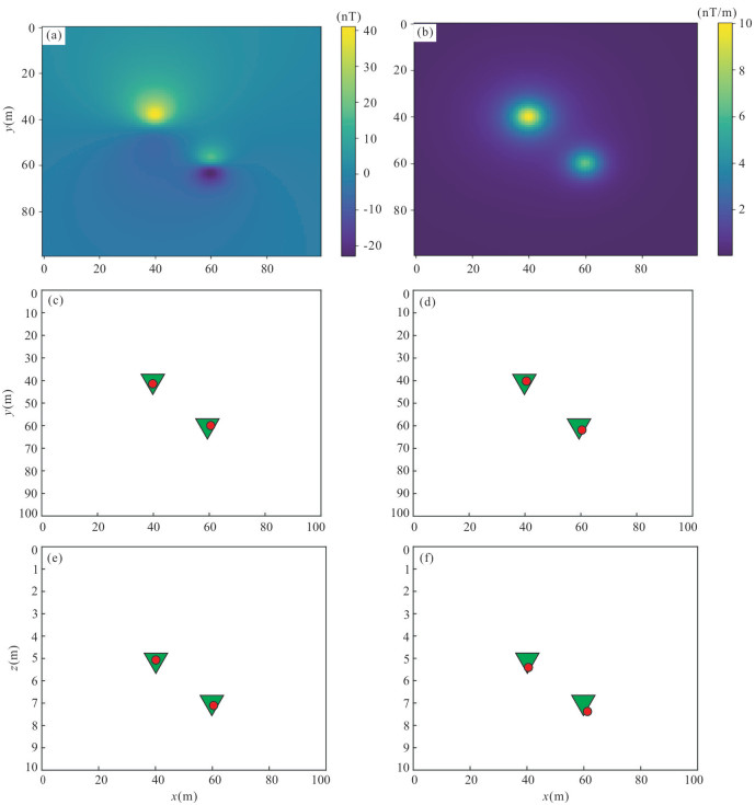
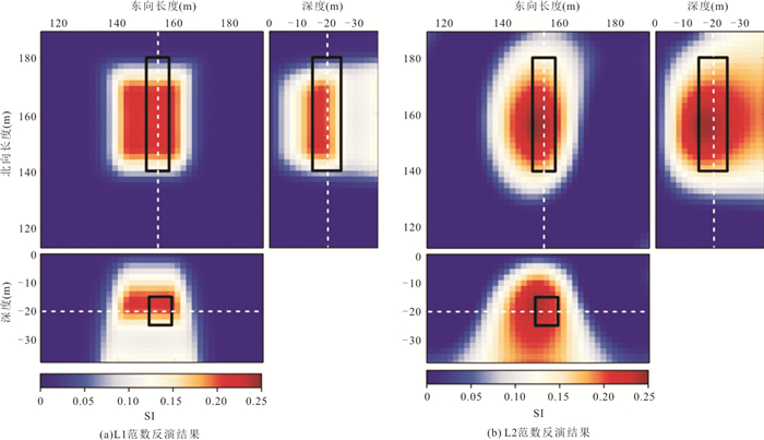
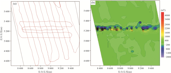
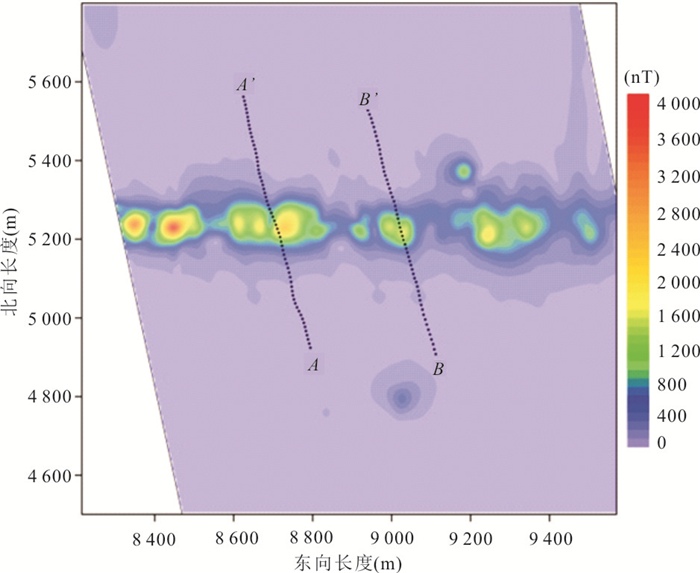
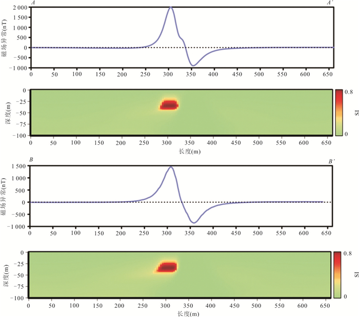
Some defects still exist in the magnetic survey for the underwater targets especially in case of the objects with small sizes. In general, the interpretation is dominated by qualitative approach and the accuracy of the quantitative results is low, which is mainly caused by the remanent magnetization and the self-demagnetization in the underwater targets. These have great impact on the analysis and inversion of the magnetic anomaly data. To obtain a robust result, the minimum-structure inversion is applied to the magnetic magnitude transform data to image the location and shape of the underwater target. In the inversion, the L1 norm and L2 norm are utilized respectively to measure the complexity of the susceptibility structure. The corresponding results show that, to recover the cuboid model, the results by the L1 norm has much clearer boundaries and that by the L2 norm much smoother. Therefore, to detect the common underwater objects, the L1 norm is more appropriate to be adopted in the inversion. Moreover, the susceptibility imaging method is applied to the field data in the island-tunnel project for the Hong Kong-Zhuhai-Macao Bridge. The practical results verify that the horizontal location, width and depth of the underwater covered pipelines can be accurately determined by the minimum-structure inversion of the magnetic magnitude transform. In short, both the synthetic and the field examples indicate that the susceptibility imaging method in this paper, can calculate the locations and sizes of the underwater covered objects accurately and thus the method is valuable to be applied to the field data.
Some defects still exist in the magnetic survey for the underwater targets especially in case of the objects with small sizes. In general, the interpretation is dominated by qualitative approach and the accuracy of the quantitative results is low, which is mainly caused by the remanent magnetization and the self-demagnetization in the underwater targets. These have great impact on the analysis and inversion of the magnetic anomaly data. To obtain a robust result, the minimum-structure inversion is applied to the magnetic magnitude transform data to image the location and shape of the underwater target. In the inversion, the L1 norm and L2 norm are utilized respectively to measure the complexity of the susceptibility structure. The corresponding results show that, to recover the cuboid model, the results by the L1 norm has much clearer boundaries and that by the L2 norm much smoother. Therefore, to detect the common underwater objects, the L1 norm is more appropriate to be adopted in the inversion. Moreover, the susceptibility imaging method is applied to the field data in the island-tunnel project for the Hong Kong-Zhuhai-Macao Bridge. The practical results verify that the horizontal location, width and depth of the underwater covered pipelines can be accurately determined by the minimum-structure inversion of the magnetic magnitude transform. In short, both the synthetic and the field examples indicate that the susceptibility imaging method in this paper, can calculate the locations and sizes of the underwater covered objects accurately and thus the method is valuable to be applied to the field data.


2021, 46(9): 3385-3396.
doi: 10.3799/dqkx.2020.342
Abstract:
Rock brittleness is one of the important mechanical properties of rock mass, which is so crucial for accurately evaluating hydraulic fracturing of oil and gas reservoir and rock bursting engineering. Existing methods of rock brittleness based on energy theory were summarized, and limitations of these indexes were analyzed in detail. In this study, energy evolution characteristics at pre-peak and post-peak stage are comprehensively considered. A new method to determine brittleness index of rocks based on complete stress-strain curves is established, which more reasonably describes the rock brittleness. To verify the rationality of the method, four sets of rock mechanics tests are collected to test the new index. Test results show that the new brittleness index gradually increases with the increase of confining pressure. Under low confining pressure, both coal and group 1 of shale exhibit strong brittleness, while under high confining pressure, the brittleness of red sandstone and group 2 of shale is obviously weakened, showing that the characteristics of brittle-ductile transition of rocks with increasing of the confining pressure. Then in actual slope engineering, the rationality of the new brittleness index is further validated by the tests of slate, which may be expected to offer some references for evaluating rock brittleness.
Rock brittleness is one of the important mechanical properties of rock mass, which is so crucial for accurately evaluating hydraulic fracturing of oil and gas reservoir and rock bursting engineering. Existing methods of rock brittleness based on energy theory were summarized, and limitations of these indexes were analyzed in detail. In this study, energy evolution characteristics at pre-peak and post-peak stage are comprehensively considered. A new method to determine brittleness index of rocks based on complete stress-strain curves is established, which more reasonably describes the rock brittleness. To verify the rationality of the method, four sets of rock mechanics tests are collected to test the new index. Test results show that the new brittleness index gradually increases with the increase of confining pressure. Under low confining pressure, both coal and group 1 of shale exhibit strong brittleness, while under high confining pressure, the brittleness of red sandstone and group 2 of shale is obviously weakened, showing that the characteristics of brittle-ductile transition of rocks with increasing of the confining pressure. Then in actual slope engineering, the rationality of the new brittleness index is further validated by the tests of slate, which may be expected to offer some references for evaluating rock brittleness.


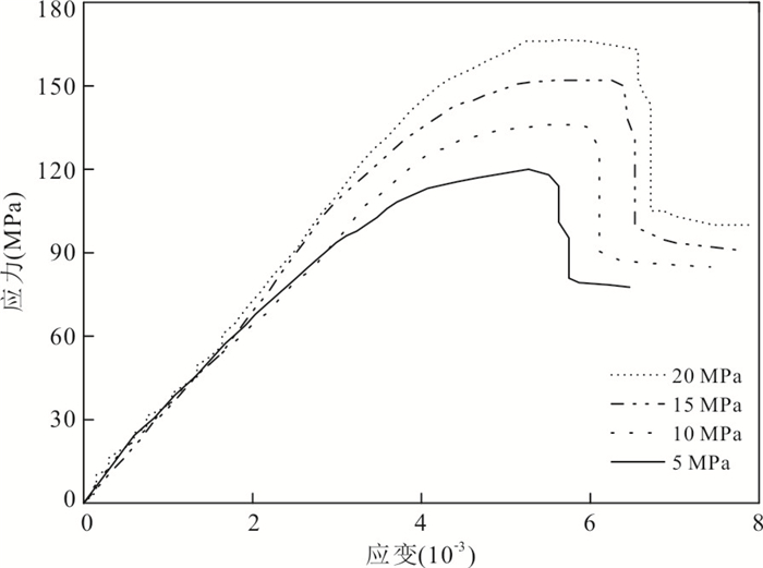

2021, 46(9): 3397-3409.
doi: 10.3799/dqkx.2020.333
Abstract:
The Baige landslide, which involved two large-scale high-elevation landslides, occurred in Boluo Township, Jiangda County, Changdu, Tibet. This catastrophic landslide blocked Jinsha River and formed a landslide-dammed lake. The consequent outburst flood caused downstream damage. The geomorphological and geological characteristics of the Baige landslide, which were defined by field surveys, engineering verification, remote sensing images, oblique photogrammetry and microscopic analysis of rocks, were investigated in combination with previous geological information. The results suggest that: (1) The Baige landslide was located on a valley-type structurally broken and loosened rock, which was developed along the Jinsha River tectonic mélange belt; (2) the slope is mainly composed of rock blocks with slightly deformed tectonic lens and intensely deformed dislocation zones (mylonite, cataclasite, and fault gouge), and it has been observed under microscope that rock structures have been greatly damaged, which reduced the rock strength; (3) both sides and the main scarp of the landslide were controlled by the fault fracture zone, which acted as the lateral and trailing cutting planes for the landslide; (4) the sliding layer of the Baige landslide was composed of the discontinuous dislocation zones, which were connected under the gravity unloading, and resulted in a multiple landslides of the slope in stages; (5) comprehensive start-up analysis of slope instability suggests the Baige landslide was a complex landslide with modes of moving and traction; (6) the Baige landslide occurred as a consequence of coupling of internal and external dynamics. In addition, the continuous eroding on slope toe by the Jinsha River, and the loose rock mass damaged under the gravity unloading also contributed to the Baige landslide. The Baige landslide event can not only provide information for studying the formation mechanism of large-scale landslides in the Jinsha River tectonic mélange belt, but also provide theoretical guidance for hazard prevention and mitigation in the region.
The Baige landslide, which involved two large-scale high-elevation landslides, occurred in Boluo Township, Jiangda County, Changdu, Tibet. This catastrophic landslide blocked Jinsha River and formed a landslide-dammed lake. The consequent outburst flood caused downstream damage. The geomorphological and geological characteristics of the Baige landslide, which were defined by field surveys, engineering verification, remote sensing images, oblique photogrammetry and microscopic analysis of rocks, were investigated in combination with previous geological information. The results suggest that: (1) The Baige landslide was located on a valley-type structurally broken and loosened rock, which was developed along the Jinsha River tectonic mélange belt; (2) the slope is mainly composed of rock blocks with slightly deformed tectonic lens and intensely deformed dislocation zones (mylonite, cataclasite, and fault gouge), and it has been observed under microscope that rock structures have been greatly damaged, which reduced the rock strength; (3) both sides and the main scarp of the landslide were controlled by the fault fracture zone, which acted as the lateral and trailing cutting planes for the landslide; (4) the sliding layer of the Baige landslide was composed of the discontinuous dislocation zones, which were connected under the gravity unloading, and resulted in a multiple landslides of the slope in stages; (5) comprehensive start-up analysis of slope instability suggests the Baige landslide was a complex landslide with modes of moving and traction; (6) the Baige landslide occurred as a consequence of coupling of internal and external dynamics. In addition, the continuous eroding on slope toe by the Jinsha River, and the loose rock mass damaged under the gravity unloading also contributed to the Baige landslide. The Baige landslide event can not only provide information for studying the formation mechanism of large-scale landslides in the Jinsha River tectonic mélange belt, but also provide theoretical guidance for hazard prevention and mitigation in the region.


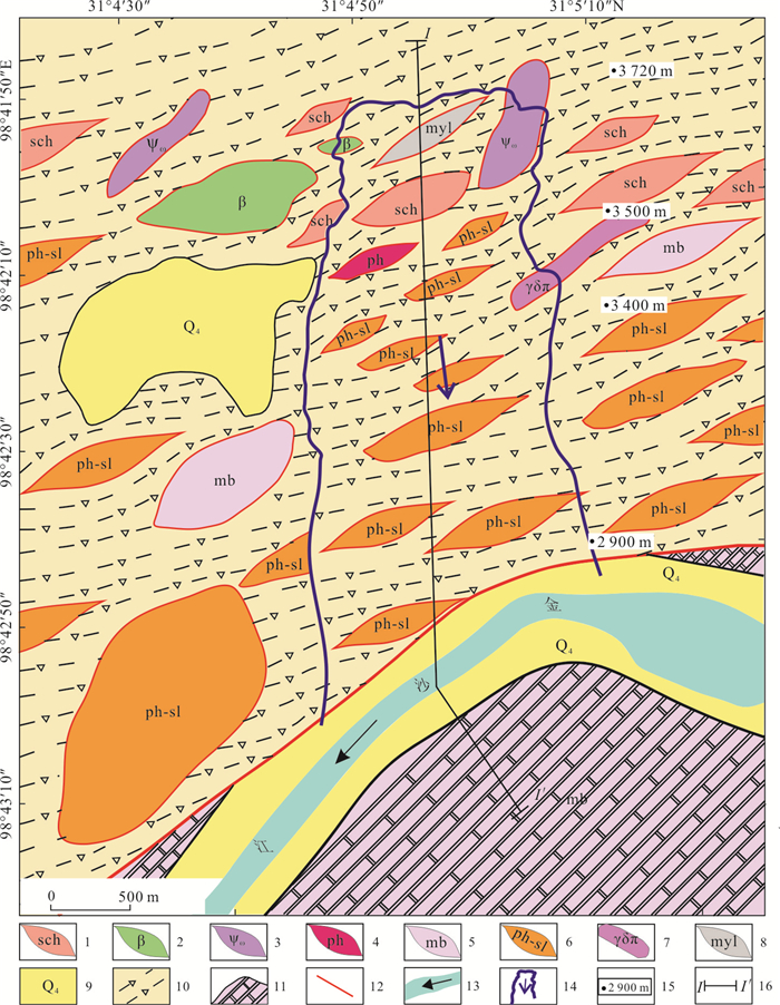

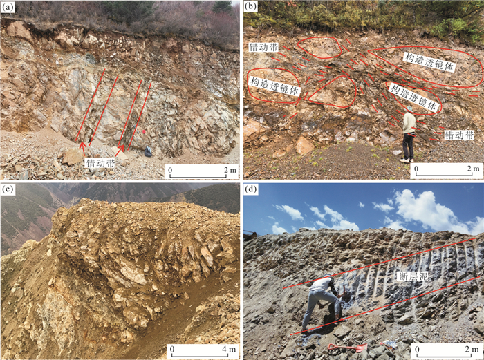


2021, 46(9): 3410-3420.
doi: 10.3799/dqkx.2020.345
Abstract:
In order to understand the indicative effect of soil structure on its hydraulic properties, undisturbed soil samples from the Ziya-River basin in the North China plain were selected as the research objects. The soil water characteristic curve was measured by tension meter method, and the particle size distribution of soil samples was measured by laser particle size analyzer. The fractal dimension of soil particle size distribution was calculated based on fractal theory. Soil water characteristic curve was analyzed by experimental measurement and model verification. The fractal dimension of soil particle size distribution in the range of[10 μm, 50 μm] is the key parameter to characterize the characteristics of the significant rising section of soil particle size distribution, which is significantly correlated with the fitting parameters (a, b) of the power function model of soil water characteristic curve in the suction range of 0-80 kPa. The power function model expressed by the fractal form of soil water characteristic curve in the study area is: θ=100.78×(3-D)S(D-3)/3, and the fractal characteristics of soil structure can effectively indicate its hydraulic properties.
In order to understand the indicative effect of soil structure on its hydraulic properties, undisturbed soil samples from the Ziya-River basin in the North China plain were selected as the research objects. The soil water characteristic curve was measured by tension meter method, and the particle size distribution of soil samples was measured by laser particle size analyzer. The fractal dimension of soil particle size distribution was calculated based on fractal theory. Soil water characteristic curve was analyzed by experimental measurement and model verification. The fractal dimension of soil particle size distribution in the range of[10 μm, 50 μm] is the key parameter to characterize the characteristics of the significant rising section of soil particle size distribution, which is significantly correlated with the fitting parameters (a, b) of the power function model of soil water characteristic curve in the suction range of 0-80 kPa. The power function model expressed by the fractal form of soil water characteristic curve in the study area is: θ=100.78×(3-D)S(D-3)/3, and the fractal characteristics of soil structure can effectively indicate its hydraulic properties.