• 中国出版政府奖提名奖

    中国百强科技报刊

    湖北出版政府奖

    中国高校百佳科技期刊

    中国最美期刊

    2022 Vol. 47, No. 11

    2022, 47(11)
    Abstract:
    CONTENTS
    2022, 47(11)
    Abstract:
    New Theories and Techniques of Fluvial Deposition
    Review on Optimization and Fusion of Seismic Attributes for Fluvial Reservoir Characterization
    Yue Dali, Li Wei, Du Yushan, Hu Guangyi, Wang Wenfeng, Wang Wurong, Wang Zheng, Xian Benzhong
    2022, 47(11): 3929-3943. doi: 10.3799/dqkx.2022.221
    Abstract:
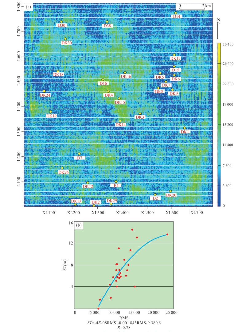
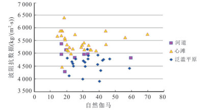
    Seismic attribute analyses have been applied widely in hydrocarbon exploration and development of fluvial reservoirs, and obtained good results. The analysis procedure of seismic attributes mainly includes the extraction, the optimization and the fusion of attributes. In this paper it summarizes the main methods of attribute extraction, optimization and fusion, and evaluates their advantages, disadvantages and application conditions. Besides, the common misunderstanding genetically related to seismic resolution and interference of neighboring zone in attribute extraction is also analyzed. Generally, fusion methods of seismic attributes using linear models cannot significantly improve the results, and are suitable for areas with several or a few wells; fusion methods with intelligent models (mainly for supervised learning) are commonly suitable for the areas with dozens of wells, such as areas within oil development stage. Fusion methods based on unsupervised learning are suitable for areas with few and even no wells, which have an optimistic development prospect since they can make full use of the seismic information, and are not limited by wells. In addition, the new fusion methods of frequency-decomposed attributes, and of attributes from target and neighboring zones are also summarized in this paper.
    Progress and Prospects in Reconstruction of Flood Events in Chinese Alluvial Plains
    Yang Jinsong, Wang Yong, Yin Jinhui, Zhao Hua, Liu Zhe, Jiang Gaolei, Zhang Peng, Qi Jiahao
    2022, 47(11): 3944-3959. doi: 10.3799/dqkx.2022.192
    Abstract:
    Alluvial plains are very important for urbanization process and human development, which are directly exposed to the risk of intense flooding in the long term. It can deepen the understanding of flood histories and patterns to conduct studies on floodplain deposits with rich information of paleoflood hydrology. By systematically reviewing the latest progress in the reconstruction of flood events in alluvial plains around the world, this paper pays high attention to the representative research in the Yangtze River Plain and the North China Plain over the last decade. The identification of paleoflood deposits at different time scales is reviewed, including sedimentary characteristics and environmental proxies. Combined with recent findings in the post-flooding investigation, sequences of multiple sedimentation layers in major flood events are summarized. In addition, depositional environments in the alluvial plain are generally divided into channel zones, channel margins and flood basins. Based on paleoflood research hotspots and frontiers, the future research firstly should focus on sedimentary features and stratigraphic relationships of flood deposits, then expand the spatial and temporal scope of flood records, explore quantitative paleoflood hydrology, and apply meta-analyses at the whole basin scale in order to gain a deeper understanding on the potential mechanism and factor.
    Main Influencing Factors of Braided-Meander Transition and Coexistence Characteristics and Implications of Ancient Fluvial Sedimentary Environment Reconstruction
    Li Shengli, Ma Shuiping, Zhou Lianwu, Huang Xiaodi, Han Bo, Li Hang
    2022, 47(11): 3960-3976. doi: 10.3799/dqkx.2022.013
    Abstract:
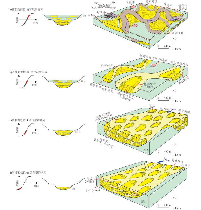
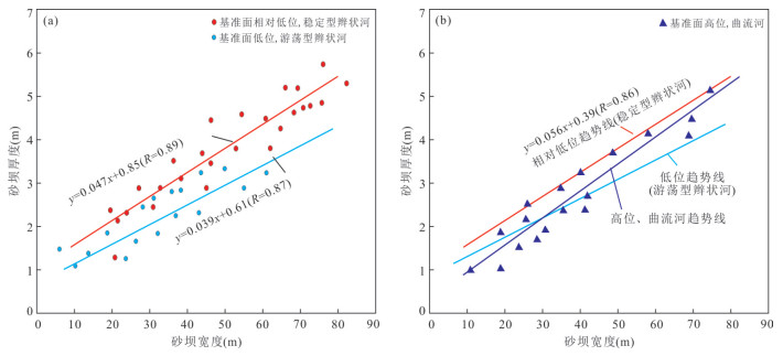
    The braided-meander transition and coexistence phenomenon is a hot issue in physical geography, hydraulics and fluvial sedimentary geology. It also has important reference significance for ancient fluvial sedimentary environment reconstruction and reservoir prediction. Firstly, it discusses the main influencing factors of the characteristics of fluvial braided-meander transition and coexistence, and points out that the main factors such as structural change and geomorphic unit, the difference of slope gradient, the distance of provenance and hydrodynamic conditions, climate change and vegetation development, sea/lake level change control the process of braid river type transformation. Among them, tectonic change and geomorphic unit are the key factors. Then, four implications of the concept of braided-meander transition on the study of ancient river sedimentary facies reconstruction are summarized. Taking the Lower Shihezi Formation in the lower part of the Middle Permian in Daniudi gas field, Ordos basin, as an example, combined with the characteristics of well-logging curves, seismic attributes and sandstone thickness distribution law, the concept of braided-meander transition and coexistence was applied to the reconstruction of ancient fluvial environment. Finally, fluvial sedimentary distribution pattern of H21 sand bed in the gas field area was reconstructed. It is indicated that braided river prevailed in the northern part and meandering river was mainly developed in the southern part in the gas field area. It is pointed out that it is easier to form abandoned river channels in the braided-meander zone and the adjacent meandering river area.
    Variable Architecture Models of Fluvial Reservoir Controlled by Base-Level Cycle: A Case Study of Jurassic Outcrop in Datong Basin
    Li Wei, Yue Dali, Li Jian, Liu Ruijing, Guo Changchun, Wang Wenfeng, Zhang Haina
    2022, 47(11): 3977-3988. doi: 10.3799/dqkx.2022.132
    Abstract:
    Most of the fluvial reservoirs have been in the late stage of oilfield development in China, and it is urgent to characterize their complex, internal sedimentary architectures. However, there are few published research documents related to differential architecture models and controlling factors, and there are not enough prediction models for oilfield reservoir architecture characterization. Therefore, taking the outcrop in Datong, Shanxi as the study area, the variable architecture models of fluvial reservoir are established by using the methods of outcrop description and measurement, GR measurement and particle size analysis. The results show that the outcrop area is divided into 9 short-term and 2 medium-term base-level cycles based on sandstone percent and ancient river depth, and the fluvial patterns at different locations of medium-term base-level cycle are obviously different. With the rising of the base level and the transition of fluvial type, architecture distribution changes from narrow and long braided bar to normal braided bar, then transitions to the combination style of narrow band braided bar or point bar, and finally evolves into horseshoe point bar. There is a good positive relationship between the thickness and width of sandy bars (braided bar or point bar), and between the width of sandy bar and the width of channel. The research results can provide guidance for similar outcrop architecture analysis and provide prediction models for the fine architecture characterization of similar oilfields.
    Depositional Setting of Ancient Pearl River Delta during Early-to-Middle Miocene: Implications for Forcing Factors
    Peng Guangrong, Du Jiayuan, Feng Jin, Ding Lin, Li Zhigao, Li Xiaoping
    2022, 47(11): 3989-4004. doi: 10.3799/dqkx.2022.390
    Abstract:
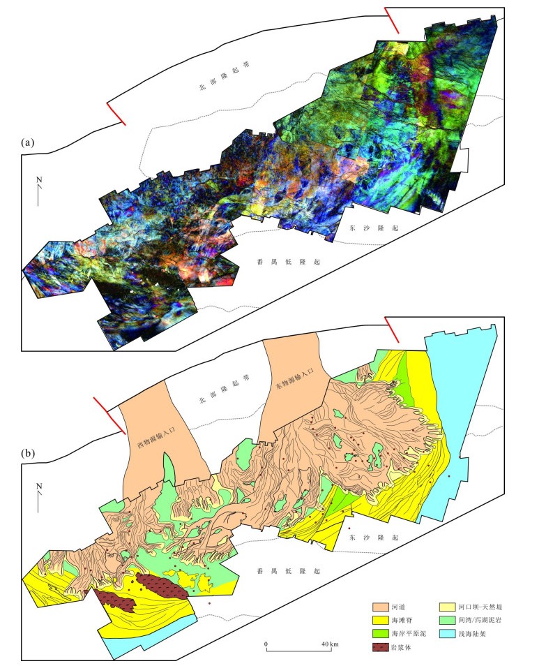
    The ancient Pearl River delta (PRD) is an important target for oil and gas exploration in the Pearl River Mouth basin, whereas its overall sedimentary characteristics have not been fully revealed, limiting the recognition of multi-type sand bodies and favorable traps in the future. Utilizing heavy mineral data, core, well logs, and large-scale 3D seismic data, we comprehensively analyze the seismic geomorphology of the ancient PRD to accurately reconstruct the distribution of sedimentary facies and the macro-sedimentary patterns of the Middle Miocene ancient PRD. Heavy mineral data analysis results show that the Paleo-Pearl River distributary channel system mainly originated from two main channel branches on the west and the east sides; thus, the basic two-branch pattern is determined in the Paleo-Pearl River delta. And the characteristics of heavy mineral assemblages on both sides are similar to those of the modern Xijiang River and the Dongjiang-Beijiang rivers, respectively, suggesting a similarity between flow pathways in the Miocene and the modern Pearl River. Meanwhile, seismic geomorphology analysis results of the distributary channel and the shore-parallel sand bodies in the distal ancient PRD show that the paleo-delta may be influenced by a hybrid dynamic process of fluvial, wave, and tide. What's more, a continuous southwest paleocurrent may have an obvious control on the overall deflected facies pattern of the ancient PRD.
    Sedimentary Evolution Characteristics and Controlling Factors of Zhongjiannan Canyons in Northwestern South China Sea
    Sun Meijing, Yao Yongjian, Luo Weidong, Hu Xiaosan, Zhou Jiao, Xu Ziying, Ju Dong, Liu Jie
    2022, 47(11): 4005-4019. doi: 10.3799/dqkx.2022.034
    Abstract:
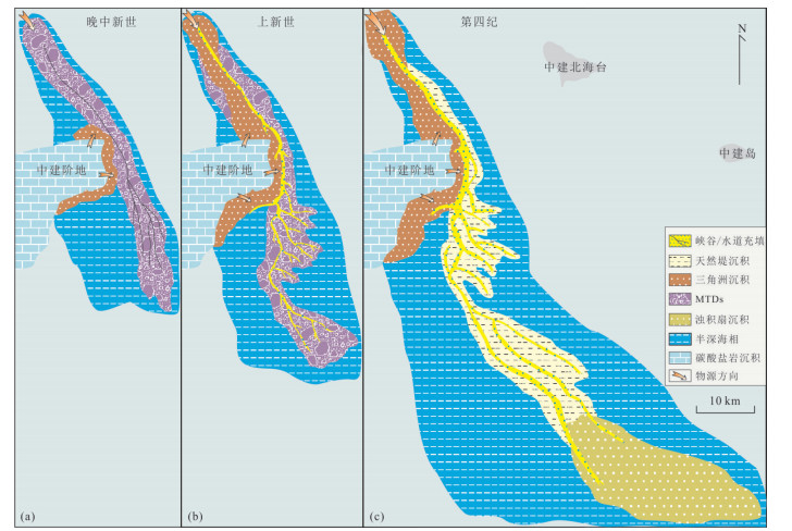
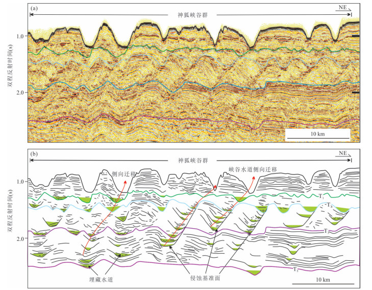
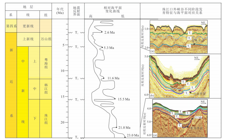
    The Zhongjiannan Canyons were first discovered in the northwest of the South China Sea. At present, relevant research on its geological information has not been carried out.Based on the comprehensive use of bathymetric topographic data and two-dimensional multi-channel seismic data, in this paper it mainly analyzes the topographic and geomorphic characteristics, plane distribution and segmentation characteristics of the Zhongjiannan Canyons, finely describes the sedimentary evolution and filling structure characteristics of the Zhongjiannan Canyons, and then further discusses the controlling factors of the canyons formation. The Zhongjiannan submarine canyons is distributed between Zhongjian terrace and Zhongjianbei platform. It is composed of a main axis canyon in the west and several small branch canyons in the east. The overall trend is SE-S-SE. According to the trend turning point of the main canyon, the Zhongjiannan canyons are divided into three sections: north section, middle section and south section. The north section is dominated by erosion, the middle and south sections are mainly affected by erosion and sedimentation, and the area outside the canyon mouth in the southeast is mainly affected by sedimentation. Canyon sedimentary systems were widely distributed in the study area from Late Miocene to Quaternary, including semi-deep marine facies, delta facies, canyon/channel filling facies, slump facies, mass transported deposits and turbidite fan facies. It is revealed that the development and evolution of the submarine canyons are mainly controlled by sea level change, sediment source supply, gravity flow and bottom current. The analysis of the topography and sedimentary evolution characteristics of the canyons will have important scientific significance for the study of marine disaster geology, deep-water sedimentary system and oil and gas resources exploration in the South China Sea.
    Quantitative Pickup of High Frequency Sequence-Time Units under Restriction of Milankovitch Sedimentary Rate in Continental Shallow Lake Basin: A Case Study of Huagang Formation in Huangyan Area, Xihu Sag
    Jia Yuerui, Liu Qianghu, Zhu Hongtao, Qin Lanzhi, Xu Donghao, Li Zhiyao, Sun Zhongheng
    2022, 47(11): 4020-4032. doi: 10.3799/dqkx.2022.273
    Abstract:
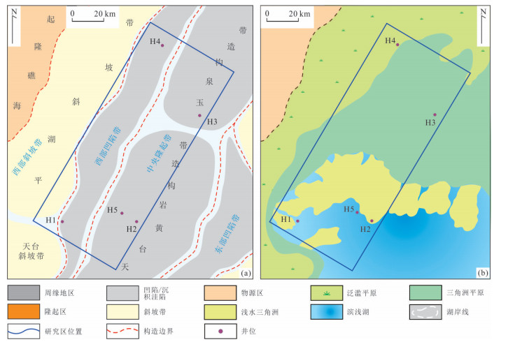
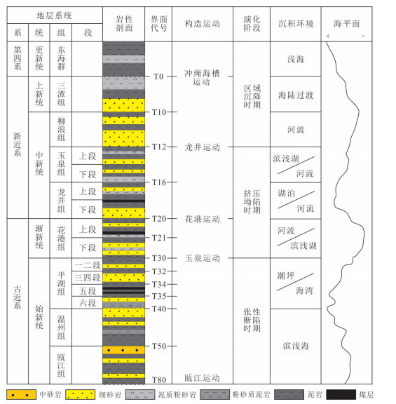
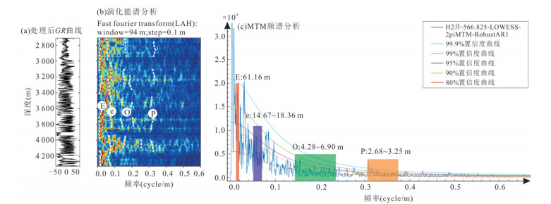
    The research object of cyclostratigraphy has gradually shifted from marine strata to continental deep-water strata. In order to explore the possibility of establishing high frequency sequence framework in continental shallow lake basin by means of cyclicstratigraphy, spectral analysis, astronomical tuning and "Milankovitch" sedimentation rate picking were used to study the lithofacies sensitive curve-GR logging data of the Oligocene depression lake basin in Huangyan area of the Xihu sag, East China Sea shelf basin. The results of spectrum analysis show that the Huagang Formation in Huangyan area is regulated by 405 ka long eccentricity period (E), 121 ka and 97 ka short eccentricity period (e), 28 ka slope period (O) and about 22 ka precession period (P). Taking the 65°N average sunshine sequence given by La2004 astronomical solution as the reference for astronomical tuning, a floating astronomical chronometer scale is established in the mud-rich areas of the lake environment. In the sand-rich area of the shallow-water delta environment, the Milankovitch sedimentation rate curve was obtained through the sliding window spectrum analysis, combined with the zircon U-Pb dating data verification and joint constraints of rock assemblage type, the high-frequency sequence framework was set up. This study shows that the duration of Huagang Formation in Huangyan area is about 10.9 Ma, and 27 long 405 ka eccentricity cycles can be identified. According to the correspondence between the eccentricity filtering curve and the sub-envelope surface of sunshine amount, there are 11 fourth-order sequences and 27 fifth-order sequences, which correspond to the base level cycles of 0.8-1.6 Ma and 0.4 Ma respectively, and each cycle is characterized by high-low-high characteristics on the deposition rate curve. This study provides a new method to construct high frequency sequence framework and pick up the interface based on the "Milankovitch sedimentation rate", which broadens the application scope of cyclostratigraphy.
    Multiple-Point Geostatistical Modeling of Braided Channel Reservoir with Constraints by 3D Seismic Data: A Case Study of M Block in Venezuela
    Huang Wensong
    2022, 47(11): 4033-4045. doi: 10.3799/dqkx.2022.203
    Abstract:
    Integrating seismic information into multi-point statistical geological modeling can improve the cross well prediction function of the model. Taking a braided river sedimentary oil-bearing block in Orinoco heavy oil belt, Venezuela, as an example, combined with the geological characteristics of braided river reservoir in this area, and using the multi-point statistical modeling method integrated well with seismic data, is this paper it studies the facies calibration of seismic wave impedance, the selection of sand-body probability generation curve, training image analysis, impact ratio between well and seismic data, and their role in multi-point statistical modeling of braided river reservoir. Then, combined with the sedimentological characteristic of braided river reservoir, the modeling results of microfacies spatial distribution such as channel bar, river channel and flood plain in the study area are analyzed. Finally, the uncertainty of different reservoir modeling results is analyzed. The research shows that the multi-point statistical modeling method integrated well and seismic data can better reduce the uncertainty of modeling results in areas with sparse well pattern. Through the probability generation curve of sandstone, the wave impedance data is transformed into the spatial probability distribution of seismic facies. In this way, the relationship between seismic data and its geological significance is effectively established. Compared with modeling only with well-logging data, the method integrated well seismic data modeling result is more reasonable for inter well microfacies prediction, and the continuity of predicted river channel and channel bar is better displayed.
    Sedimentary Characteristics, Evolution and Controlling Factors of the Pearl River Canyon System in the Northern South China Sea
    Du Wenbo, Nie Xin, Yang Chupeng, Hu Xiaosan, Gao Hongfang
    2022, 47(11): 4046-4059. doi: 10.3799/dqkx.2022.166
    Abstract:
    The coarser clastic sediment in deep-water submarine canyons is a hot topic in the field of marine geology, not only because it can be good oil and gas reservoirs, but also because it records the complete information of marine geological environment change. In order to reveal the sedimentary evolution process and controlling factors of the Pearl River Canyon system, in this paper it combined multibeam bathymetric and high resolution 2D multi-channel seismic data to study the topography characteristics, sedimentary filling characteristics, the formation processes and controlling factors of the Pearl River Canyon system. The study shows that Pearl River Canyon system has developed in three sections. The upper section is in NW-SE trend, with a width of more than 30 km, low erosion intensity, and irregular cross section. The middle section is in E-W trend, with narrower width (25-30 km), and U-shaped cross section. The lower sections is in NW-SE trend with the largest width (25-45 km) and U-shaped cross section. The middle and the lower sections are dominated by sedimentation. The evolution of Pearl River Canyon system could be divided into three stages: the early stage (23-15.5 Ma), the channel-submarine fan form stage (15.5-11.6 Ma) and the canyon-submarine fan/block flow stage (11.6-0 Ma). It's revealed that the development and evolution of the Pearl River Canyon system are mainly controlled by tectonic movement, sea level change and sediment supply. The above analysis has practical significance for the study of marine disaster, deep-water depositional system and hydrocarbon resources exploration in the northern South China Sea.
    Reservoir Superposed Pattern Characterization of Well-Logging and Seismic Data Calibration with Meandering Channels: A Case Study of Jurassic Toutunhe Formation in Fudong No.5 Well Area, Eastern Junggar Basin
    Yin Senlin, Zhang Tong, Tang Wenjun, Xia Ping, Yue Dali, Yu Fenglin, Huang Fan, Chen Xu
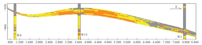
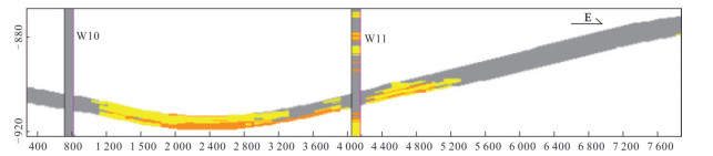
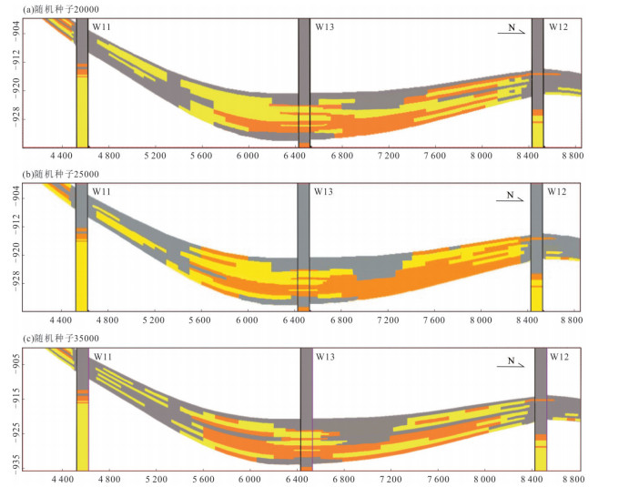
    2022, 47(11): 4060-4074. doi: 10.3799/dqkx.2022.168
    Abstract:
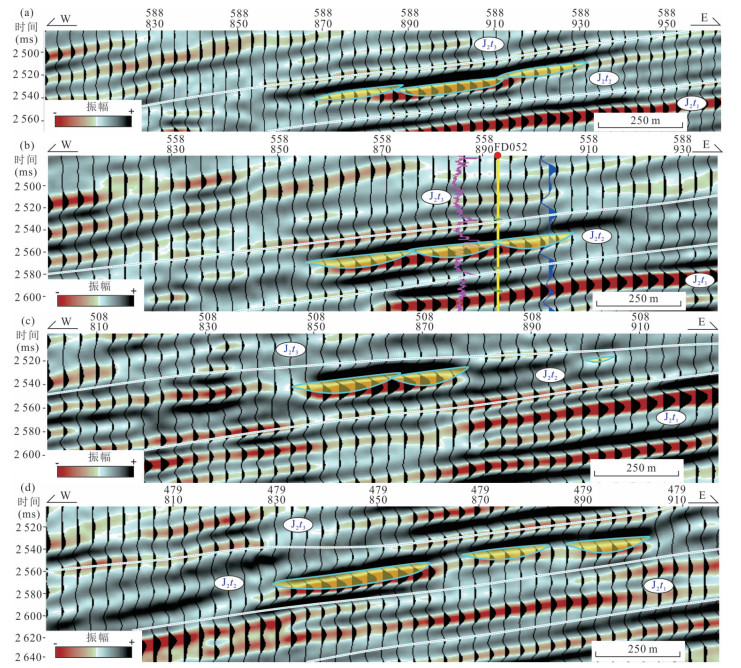
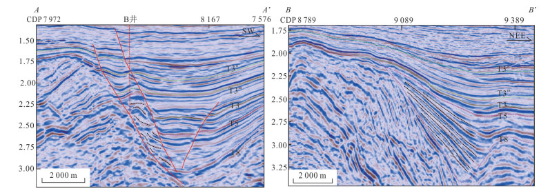
    Characterization of meandering channel reservoir superposed pattern is difficult to Fudong No.5 well area with large well spacing. Using the data of core, seismic, logging, and production test, and the methods of well-logging seismic data calibration, hierarchical architecture, and seismic forward modeling, in this study it established the microfacies, hierarchical meandering channel sand bodies, and the response characteristics of the waveform in the seismic forward modeling of superimposed channel sand body. The results show follows: (1) It is a complete cycle from bottom to top, with meandering river delta, distributary channel system to meandering river. At the first member, it is the development of meandering river delta depositional system, superposition of multiple lobes sand body. At the second member, it has evolved into meandering distribution channel system, and the sand body is stacked with banded shape. At the third member, it is the meandering river depositional system, and the sand body is wide banded shape overlapped. (2) There are four classes of the meandering channel to be launched in seismic forward modeling, after setting up the reasonable parameters of the work area. The relationship between developmental stages of single channel can be comprehensively determined by the well-logging calibration and the monoclinal, stepped, concave characteristics that overlapping of single channels at different periods shows in the seismic reflection, along with the transverse strength change of the amplitude. (3) The meandering channel sand bodies in the study area can be divided into three types: single channel, multi-channel superposition and stable migration channels. The single channel type seismic reflection amplitude is strong in the middle and weak on both sides, presenting a continuous banded distribution, with a width about 250 m, while the multi-channel superimposed type seismic reflection amplitude is greatly varied in strength and the distribution of superimposed banded poorly continued, with a width about 500 m. The stable migration channel type seismic response waveform changes weakly and continuously, presenting a large range of continuous distribution, and a width about 1 500 m. The research is not only of great practical significance for improving oil recovery of meandering channel reservoirs by using horizontal wells, but also of great significance for enriching characterization method of large well spacing meandering channel architecture combined with well-logging and seismic.
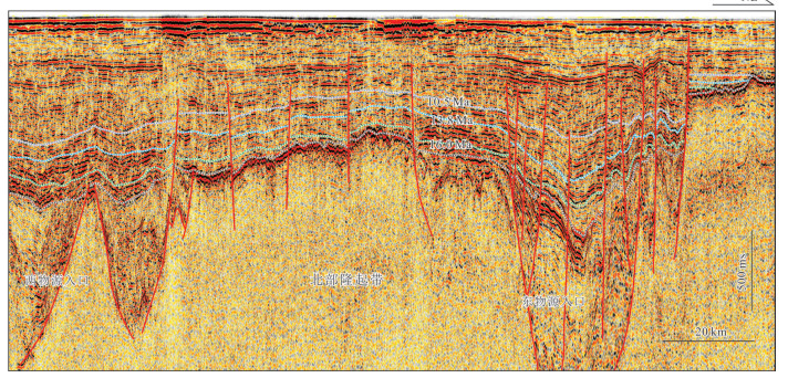
    Paleo-Drainage Restoration and Prediction of Sedimentary Coupling Response in the Southern Bohai Sea
    Shi Wenlong, Yang Haifeng, Du Xiaofeng, Gao Yanfei, Liu Rui, Tu Xiang
    2022, 47(11): 4075-4092. doi: 10.3799/dqkx.2022.022
    Abstract:
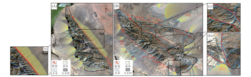
    The modern drainage systems of Jargalant Nuruu and Turgen-Kharkhiraa mountain systems in Inner Mongolia and the paleo-drainage systems of Chengbei low uplift and Bonan low uplift in Bohai Bay basin were picked up by Global Mapper and ArcGIS software, combining the boundary conditions, fracture style and parent lithology, it is considered that water systems are diverse under the combined styles of three elements. Boundary conditions influence the degree of convergence, with low convergence degree of water system in steep slope, and high degree of convergence in slow slope belt. The fracture pattern affects the direction of the water system, in which the boundary fracture intersects the water system vertically, and the oblique crossing fracture develops in the same direction as the water system. Igneous rock has various water system styles, whereas carbonate stratigraphic water system is mainly subparallel, and metamorphic rock formation has dendritic water system. On the whole, there are five styles of single parallel, feather, pectinate, subparallel and dendritic water systems developed. Combining modern source-to-sink system with ancient source-to-sink system of Bohai Bay basin, it shows that different drainage patterns correspond to different sedimentations, including (1) the source system of slow slope/stable slope-boundary fracture-igneous rock/metamorphic rock primary develop firstly water system-dendritic water system, that deposition comprises slope fan and braided river delta, that fan body is large and independent with sand-rich type; (2) slow slope/stable slope-parallel fracture-carbonate rock/igneous rock develop secondary water system-subparallel water system, the sediment comprises alluvial fan and fan dalta, that fan body is small and independent with mud-rich type. The ancient and modern analogy and verification effectively facilitate the prediction of high-quality sedimentary bodies in the underground sedimentary area by accurately picking up the distribution and development characteristics of the water system in the source area, which plays an important role in promoting the coupling of source-to-sink system elements and the exploration and prediction of underground large-scale reservoirs.
    70th Anniversary of China University of Geosciences
    Could Continents Really Drift?
    Ren Jishun, Xu Qinqin
    2022, 47(11): 4093-4097. doi: 10.3799/dqkx.2022.881
    Abstract:
    Wegener's idea of continental drift stemmed from an intuitive impression of the coincidence of both sides of the Atlantic Ocean. This coincidence is represented by the fit of coastlines of South America and Africa on both sides of the Atlantic. In recent decades, however, the submarine geophysical and geological investigations have discovered that the magnetic anomalies, seismic tomographic images and seismic profiles of the Atlantic Ocean and the continents on its both sides, and the zircon ages of the determined rocks in mid-ocean ridge indicate the formation of the ocean by continental rifting. There is no significant horizontal displacement of the continents on both sides. Furthermore, the existence of continental roots as deep as 300-400 km in the world's continents seem to have basically denied the possibility of large-scale continental drift.
    Research Progresses and Challenges of Mercury Biogeochemical Cycling in Global Vegetation Ecosystem
    Feng Xinbin, Wang Xun, Sun Guangyi, Yuan Wei
    2022, 47(11): 4098-4107. doi: 10.3799/dqkx.2022.882
    Abstract:
    Mercury (Hg) is a global pollutant which has been listed by the United Nations Environment Programme focusing on control. Vegetation is a foundational link between atmosphere and pedosphere, and plays an important role in global Hg cycles. Currently, vegetation has been regarded as the important global sink of atmospheric Hg. However, the distinct knowledge gaps in Hg cycling among interface of air-vegetation-soil, and Hg distribution, sources, transformation and their biogeochemical mechanisms in vegetation components, lead to the current global Hg models with the poor parameterization schemes of vegetation related Hg processes. These largely restrain the comprehensive quantification of the vegetation sink for atmospheric Hg across the globe. Recently, the quickly developing Hg isotopic chemistry, HR-XANES/micro-XANES, and micro meteorological mercury flux observation technology provides a new insight in understanding the interface Hg biogeochemical processes among vegetation-soil-air surfaces, and assessing Hg sources and transformation and translocation in vegetations, specifically in forest ecosystems.
    On Astrobiological Research in China
    Lin Wei, Shen Jianxun, Pan Yongxin
    2022, 47(11): 4108-4113. doi: 10.3799/dqkx.2022.883
    Abstract:
    The search for extraterrestrial habitable environments and signs of life is one of the major scientific objectives of deep space exploration. As a disciplinary regime that studies the origin, evolution, distribution, and future of life associated with the evolution of planetary systems, astrobiology systematically enlists practices across multiple disciplines, such as earth science, life science, space science, astronomy, and chemistry. In recent decades, the research of astrobiology has been progressively extended as the understanding of other celestial bodies is improved. Here we review the research content and development of astrobiology, discuss relevant opportunities and challenges in China, and provide prospects for the future.
    Volcanic Eruption Mechanism, Climate Impacts and Volcano Geoengineering
    Ma Changqian, Zou Bowen, Huang Guizhi
    2022, 47(11): 4114-4121. doi: 10.3799/dqkx.2022.415
    Abstract:
    Volcanoes are the link connecting the Earth's interior and surface systems and are seen as a sign of the vitality of the Earth. Mitigating the impact of large volcanic eruptions on Earth's climate and environment is a major topic in geosciences. In this paper we propose that in order to reduce the negative impact of volcanic disasters on all human beings, it is necessary to explore the incremental assembly and evolution of magma reservoirs, study the triggering mechanism of volcanic eruptions, focus on the interaction between the inner and outer layers of the Earth, and understand the feedback relationship between volcanic activity and global climate and surface environmental changes, and construct the theoretical system and technical framework of volcano geoengineering. Among them, the study of magma plumbing systems based on magma dynamics and volcanology will provide a new theoretical basis for the prediction and monitoring of volcanic activities. The influence of volcanic activity is global. Therefore, it must seize the opportunity to make progress in deepening the theoretical research on the mechanism of volcanic eruption and building an engineering technology system to reduce the impact of volcanic disasters.
    Recent Advances in U-Th-Pb Dating of Accessory Minerals by Laser Ablation Inductively Coupled Plasma Mass Spectrometry
    Luo Tao, Hu Zhaochu
    2022, 47(11): 4122-4144. 
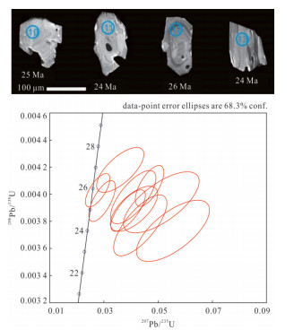
doi: 10.3799/dqkx.2022.365
    Abstract:
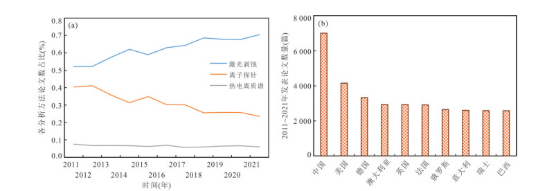
    Laser ablation inductively coupled plasma mass spectrometry (LA-ICP-MS) U-Th-Pb dating technique provides crucial temporal constraints to accurately determine geological evolution history and explore important geological processes such as diagenesis and mineralization, which is an important technical support for the rapid development of geochronology. In this study, it summarizes the important progress of LA-ICP-MS U-Th-Pb dating technique in elemental fractionation correction, non-matrix matched analysis, reference material development, common lead correction, high spatial resolution and high efficiency analysis. Looking into the future, further investigations on the mechanism of elemental fractionation and matrix effect, characterization of more kinds of high-quality reference materials, and development of more accurate, more precise, and more efficient LA-ICP-MS U-Th-Pb dating methods with higher spatial resolution are needed. These new established methods and techniques will help the geoscientists investigate the geological problems from a more microscopic and delicate perspective, and those will continue to provide critical supports for the advances and innovations in earth and planetary science research.
    Morphology of Lunar Soil Returned by Chang'E-5 Mission and Implications for Space Weathering
    Gu Yi, Sun Jiyao, Xiao Qian, Li Yiheng, Wang Xinyi, Cao Kenan, Liu Yiting, He Qi, Yang Hao, Chen Qian, Yang Jinkun, Song Wenlei, Zong Keqing, Zhang Wen, Wu Xiang, Hu Zhaochu, Xiao Long, She Zhenbing, Wang Zaicong
    2022, 47(11): 4145-4160. doi: 10.3799/dqkx.2022.432
    Abstract:
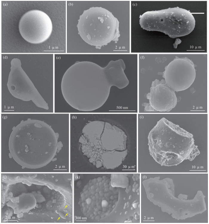
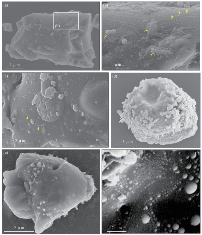
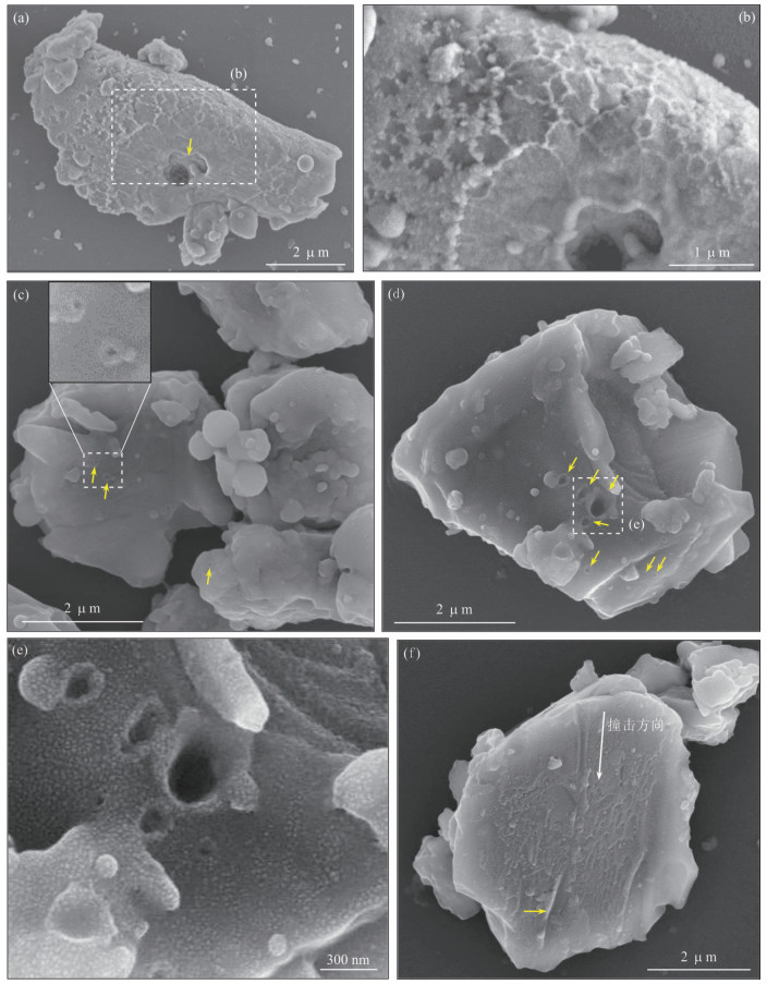
    Morphologic, structural and compositional characteristics of the lunar soil returned by Chang'E-5 provide invaluable insights into the origin of the lunar soil and the evolution history of the Moon' s surface. Using scanning electron microscopy-energy dispersive spectrometer and micro-Raman spectrometer, the scooped lunar soil sample CE5C0400 (YJFM00403) was systematically investigated. The lunar soil consists of a variety of particles, including single minerals such as plagioclase, clinopyroxene and olivine, basaltic clasts, agglutinates and glass beads. The surface features and microstructures of the particles are characterized by diverse, micrometer to nanometer scale morphological features in the form of fragmentation, surface attachment and microcratered and sputtered structures. The morphological features of Chang'E-5 lunar soil have recorded a wealth of information about the complex processes of space weathering dominated by micrometeorite impacts. Repeated impacts led to the fragmentation and fining of lunar soil particles, whereas impact-induced local melting welded the particles, accompanied by the formation of micrometer to submicrometer metal spheres through decomposition of iron-bearing minerals. Repeated cycles of these complex processes thus have resulted in significant changes in the particle sizes and mineral components of the lunar soil.
    Spatial-Temporal Distribution of Arsenic in Groundwater System in Tian-E-Zhou Wetland of the Yangtze River and Its Controlling Mechanism
    Jin Ge, Deng Yamin, Du Yao, Tao Yanqiu, Fan Hongchen
    2022, 47(11): 4161-4175. doi: 10.3799/dqkx.2022.344
    Abstract:
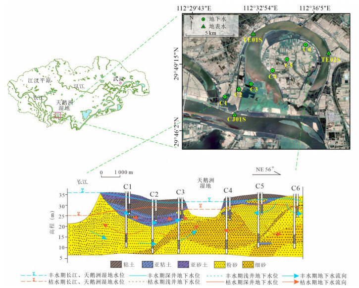
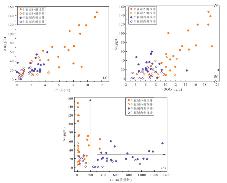
    High arsenic groundwater not only directly endangers water supply safety, but also affects the water quality of wetlands and thus threatens the ecological safety of wetlands through the long-term interactions between groundwater and surface water. The spatial distribution of arsenic in groundwater in the Tian-E-Zhou wetland in the middle reach of the Yangtze River has been reported to be wide, but the spatial distribution characteristics of arsenic in groundwater in the Tian-E-Zhou wetland in the middle reach of the Yangtze River are still not clear, and the control mechanism of the interaction between the wetland and groundwater on the seasonal dynamics of arsenic in groundwater is not clear. In this study, 35 sediment samples from 2 hydrogeological boreholes, a total of 72 sets of groundwater samples and 18 sets of surface water samples from 12 stratified monitoring wells in different seasons were collected in the Tian-E-Zhou wetland, and the spatial-temporal distribution patterns and control mechanisms of arsenic in groundwater in the Tian-E-Zhou wetland were investigated by water level-water chemistry monitoring, sediment geochemical composition analysis and arsenic-iron morphological characterization. It was found that the arsenic content of groundwater in the Tian-E-Zhou wetland ranged from 1.08 to 147.00 μg/L. The arsenic content of groundwater in shallow wells (10 m) under the outer side of the Oxbow Lake was generally higher than that in deep wells (25 m) and groundwater under the inner side of Oxbow Lake, and the arsenic content in the non-monsoon was higher than that in the monsoon. The shallow groundwater system under the outer side of the Oxbow Lake has thicker clayey and sub-clayey deposits with higher total arsenic, strongly adsorbed state arsenic and easily reduced iron oxides in the sediments, and reductive dissolution of amorphous iron oxides such as ferrihydrite minerals that adsorb arsenic leads to the release of arsenic into the groundwater. The transport of reactive organic matters from the bottom of the Tian-E-Zhou wetland to the shallow aquifer outside the Oxbow Lake during the non-monsoon makes the groundwater-surface water interface of the Tian-E-Zhou wetland a hot spot area for arsenic release. During the monsoon, the aquifer on the outer side of the Oxbow Lake is influenced by the recharge of the Yangtze River, and the reduction environment is changed so that the arsenic and iron in the groundwater are fixed by oxidation, which is detrimental to the release of arsenic to the groundwater.
    Removal of Aniline from Groundwater by an Electrochemical-Hydrodynamic Cyclic Coupling In-Well Bioreactor
    Li Shuang, Wen Zhang, Zhu Qi, Liu Hui, Yang Shuting
    2022, 47(11): 4176-4183. doi: 10.3799/dqkx.2022.375
    Abstract:
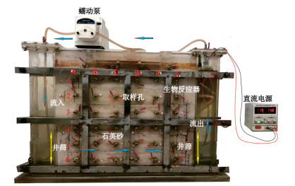
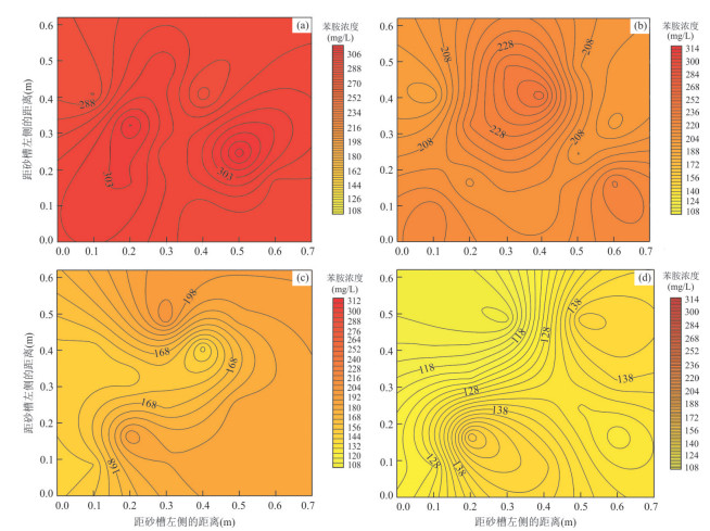
    To ensure the efficient and safe in-situ remediation process of aniline contamination in aquifer without secondary pollution, a method for the remediation of aniline in groundwater by an in-well bioreactor under electrochemical and hydrodynamic cycle is proposed. Driven by the hydrodynamic circulation system, the volatilization of aniline in the hydrodynamic circulation system was evaluated and oxygen was provided by electrochemical means. The bioreactor in the well provided the repair carrier. The remediation experiment of aniline degradation by the bioreactor in the well was carried out in the aquifer system simulated by the sand tank. The growth curve and aniline restoration in aquifer were simulated. After 289 hours of repair, the average concentration of aniline in the system was reduced from 298 mg/L to 132 mg/L, and the removal rate was 56.5%. During operation, the removal rate of aniline was 1.10 mg/(L·h) in 48 h, 0.85 mg/(L·h) in 48-72 h, and 0.65 mg/(L·h) in 72 h to 289 h. Oxidative degradation was gradually weakened. The process conforms to the Michaelis-Menten equation, and the reaction rate is -6.71×10⁻⁷/(15+t)2. This system is based on the improvement of groundwater dynamic circulation technology, and is expected to be applied to organic groundwater remediation.
    Experimental and Simulation Study on Reaction Migration of Chlorinated Hydrocarbons Based on Electrochemical-Hydrodynamic Circulation System in Sand Tank
    Tan Haoyue, Wen Zhang, Zhu Qi, Yang Shuting, Cai Qizheng, Liu Hui
    2022, 47(11): 4184-4195. doi: 10.3799/dqkx.2022.397
    Abstract:
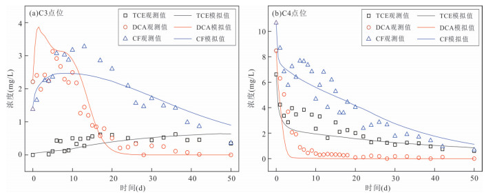
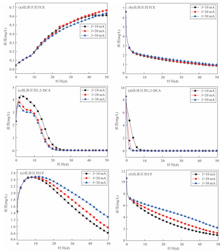
    Using a subsurface electrochemical-hydrodynamic circulation system as a remediation technology, this study developes a reactive transport model of mixed chlorinated hydrocarbons in laboratory sand box experiments. The reaction kinetic parameters of each typical chlorinated hydrocarbon are estimated, revealing the influence mechanisms of aquifer properties and technological parameters on this remediation performance through the electrochemical-hydrodynamic circulation system installed in the sand tank experiment. The results indicate that: (1) An increasing pumping rate can accelerate the degradation of chlorinated hydrocarbons with large reaction rate, on the contrary, a greater pumping rate inhibits the degradation with small reaction rate. (2) An increasing electric current intensity and the in-well electrode facilitate and inhibit the aerobic degradation and anaerobic dechlorination of chlorinated hydrocarbons, respectively. (3) A stronger heterogeneity of aquifer leads to a worse performance of chlorinated hydrocarbon degradation, especially in the low-permeability region; and the influence of aquifer heterogeneity on the remediation performance of easily degradable pollutants is very slight.
    Stream Runoff Formation and Hydrological Regulation Mechanism in Mountainous Alpine Regions: A Review
    Chang Qixin, Sun Ziyong, Pan Zhao, Li Zhaofeng
    2022, 47(11): 4196-4209. doi: 10.3799/dqkx.2022.093
    Abstract:
    The formation and regulation mechanism of stream runoff in mountainous alpine regions is the basis of understanding the formation mechanism and transformation process of water resources in basins and predicting the response of hydrological processes in alpine watersheds to climate change. By analyzing relevant literature on hydrological processes in cold regions, we reviewed their research progress from the following three aspects: (1) the water source of stream runoff in mountainous alpine regions and its influence mechanism under climate change, (2) the regulation mechanism of stream runoff on different underlying surfaces in mountainous alpine regions, (3) the regulation mechanism of groundwater on stream runoff in mountainous alpine regions. We found that climate change was the dominant factor affecting the formation process of stream runoff in mountainous alpine regions. Moreover, the response relationship between the secondary influencing factors of stream runoff formation (such as hydrological inputs, underlying surfaces, groundwater) and climate change in mountainous alpine regions is the key to revealing the regulation mechanism of stream runoff. We proposed the future research trend and suggestions for improvement, providing a theoretical basis for the runoff formation mechanism and its response to climate change in the mountainous alpine regions.
    Taxonomic Diversity and Functional Diversity of Benthic Communities during Permian-Triassic Crisis at Zhonghe Section, Shuicheng, Guizhou Province
    Zhao Junjie, Huang Yunfei, Ji Xia, Chu Daoliang, Tong Jinnan
    2022, 47(11): 4210-4221. doi: 10.3799/dqkx.2022.262
    Abstract:
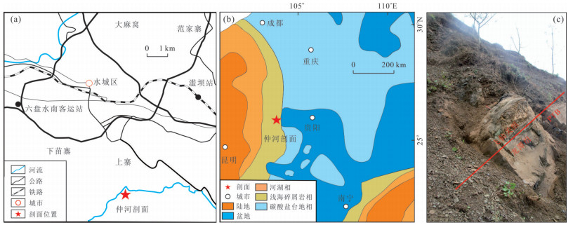
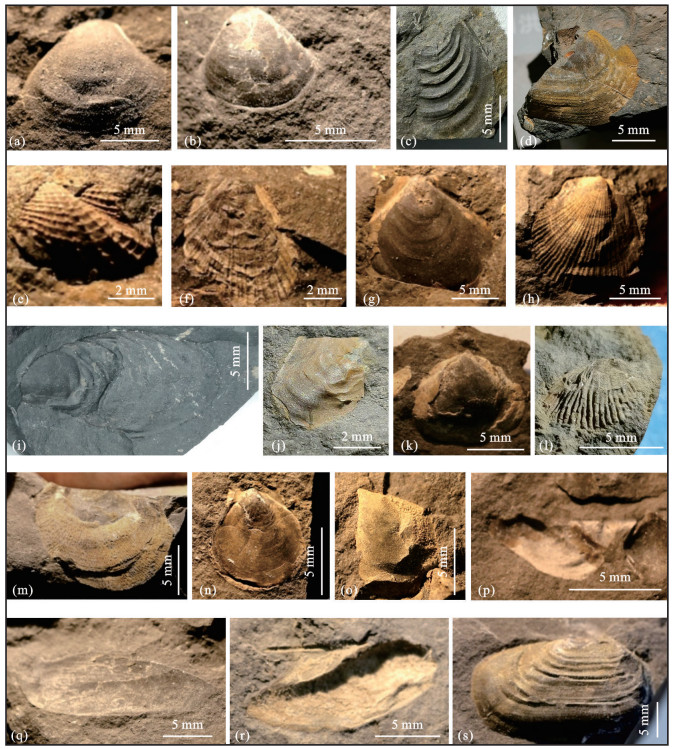
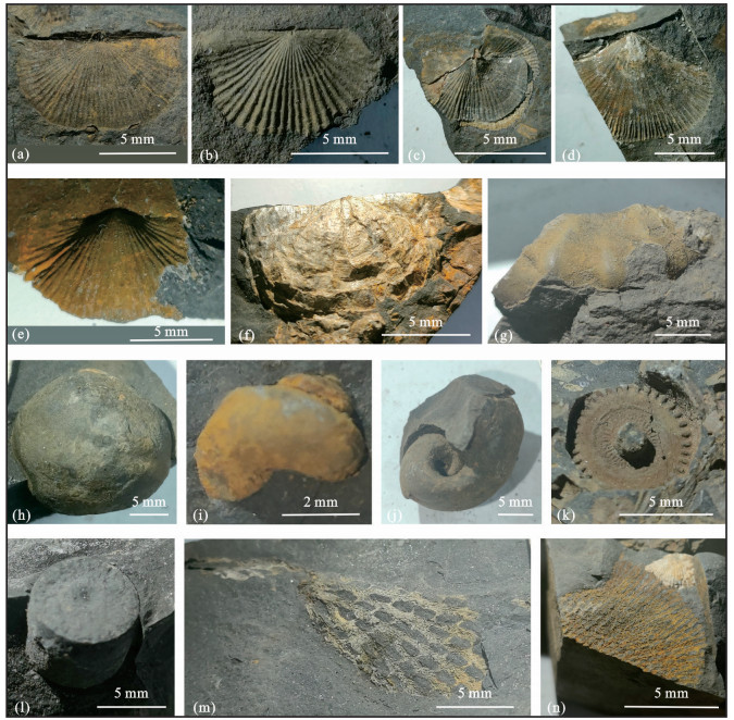
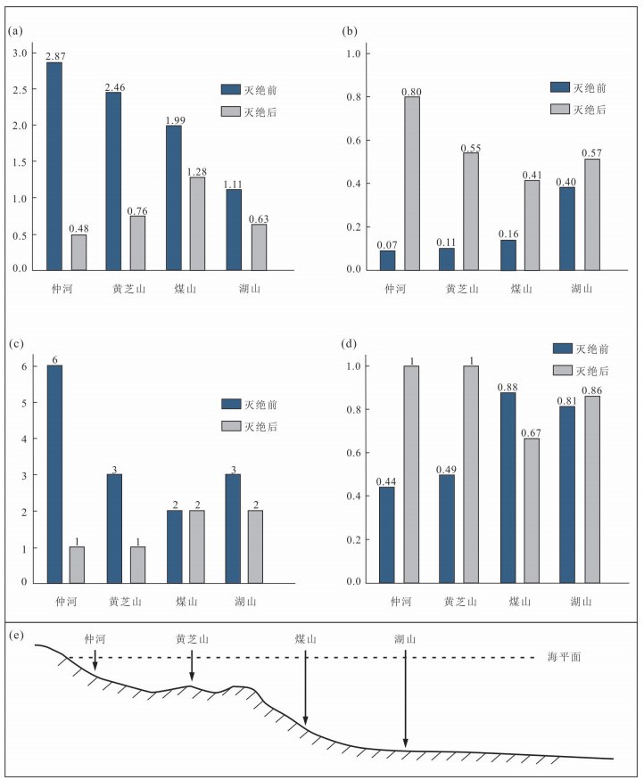
    In order to evaluate the impact of the End-Permian mass extinction on the taxonomic diversity and functional diversity of benthic communities, this study carried out a successive collection of macrofossils through the Permian-Triassic boundary sequence at the Zhonghe Section, Shuicheng, Guizhou Province, and reconstructed the palaeocommunities. The taxonomic diversity is indicative of the Shannon index, dominance index and evenness index, while the functional diversity includes functional group richness and functional evenness. A total of 1 340 fossil specimens were collected in this study, and they could be assigned to 33 species in 30 genera, and could be grouped to two bivalve zones: the Hunanopecten exilisacme zone in the Changhsingian (Late Permian), and the Pteria ussurica variabilisacme zone in the Early Griesbachian (Early Triassic). Three paleocommunities were identified through cluster analysis: Astartella obliqua-Tethyochonetes quadrata community, Pteria ussurica variabilis-Claraia wangi community and Pteria ussurica variabilis-Unionites canalensis community. The Shannon index decreased, dominance increased, evenness decreased, functional group richness decreased and functional evenness increased, indicating that the End-Permian mass extinction significantly damaged the composition, structure and function of the shallow marine benthic community. Besides, in combination with various paleocommunities from South China, it is found that both the species diversity index and the functional diversity index of the benthic community changed synchronously between shallow and deep marine environments. However, the shallow marine paleocommunities were more affected than their counterparts from deep sea.
    First Discovery of Middle Jurassic Theropod Trackways in Changdu Region, Eastern Tibet of China
    Li Yangui, Yao Huazhou, Foster William J., Xing Lida, Wang Chuanshang, Tahir Asma, Khan Junaid, An Zhihui, Zhao He, Wang Jianxiong
    2022, 47(11): 4222-4244. doi: 10.3799/dqkx.2022.395
    Abstract:
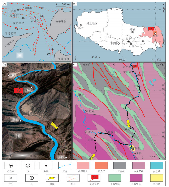
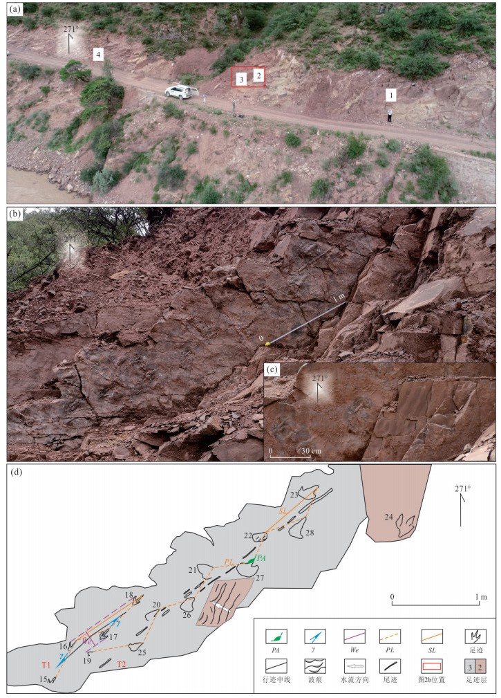
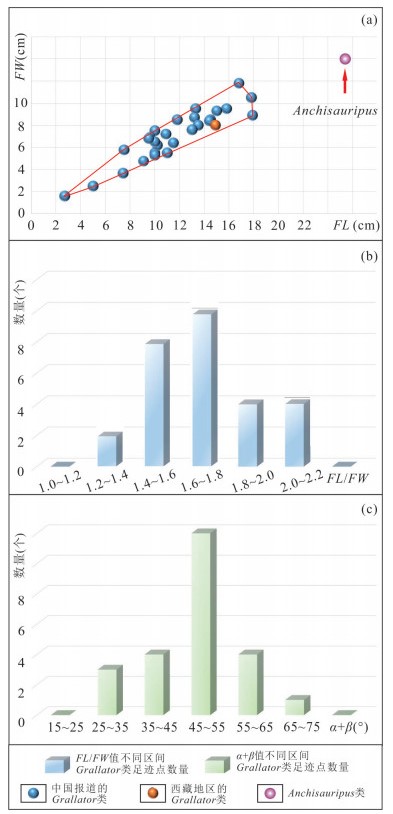
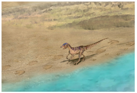
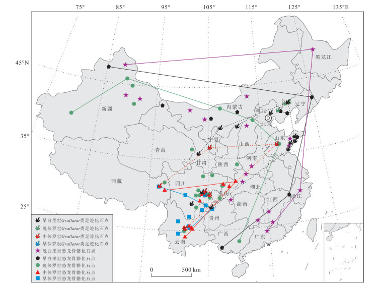
    A new dinosaur track site, Anietang site, was discovered in Changdu region of eastern Tibet. The lithostratigraphy of this track site is mainly lakeside purplish red medium-fine sandstone of the Middle Jurassic Dabuka Formation. Four exquisitely convex track layers (footprint types including Grallator, large theropods, small theropods and small sauropods) and two perfect track-ways were found. Four sequential Grallator footprints that make up the T1 trackway are named Grallator anietangensis isp nov., and a detailed morphological analysis was performed on it. It is doubtless that the Grallator was found in Tibet for the first time, and the size and gait of track-maker are discussed. Nine large theropod footprints that make up T2 trackway are classified as Theropoda igen et isp. indet.. The current study has described the morphology of Theropoda igen et isp. indet., and it is determined that this kind of footprint is found for the first time in China. The consecutive and clear trail tracks of T2 indicate that the trackmaker was not in a normal gait, but a special behavior to deal with a particular situation. It is speculated that the trackmaker was detecting situation with its raised body while walking at a very low speed. The forequarters were raised, resulted in the tail to sag correspondingly, and left trail tracks. Both trackways show that the trackmakers were walking along the bank of ancient Changdu Lake. At present, the dinosaur skeletons and the Grallator footprints found in China all show a migration pattern with the Southwest China as the center and then spreading around. But the speed of dinosaur migration reflected by the Grallator footprints is faster than that of skeletons.
    Deep Structures and Lithospheric Breakup Processes at Northern Continent-Ocean Transition Zone of the South China Sea
    Peng Xi, Li Chunfeng, Song Taoran, Wan Xiaoli, Hou Wenai, Wen Yonglin, Li Yaqing, Liu Yutao, Tang Fugui
    2022, 47(11): 4245-4255. doi: 10.3799/dqkx.2022.366
    Abstract:
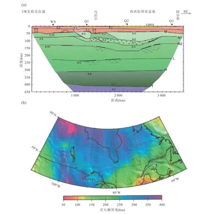
    Continent-ocean transition zone is a key position to understand the breakup of continental lithosphere and the initial seafloor spreading processes, but some questions about related geological processes still remain controversial in the northern margin of the South China Sea (SCS) today. Four new perspectives have been acquired by International Ocean Discovery Program (IODP) and deep geological and geophysical surveys in recent years. (1) Spatially, the continent-ocean boundary generally corresponds to positive-negative transition zone of the free-air gravity anomaly, but more accurate delimitation needs to be calibrated with seismic reflection and refraction data. True continent-ocean boundary between steady oceanic lithosphere and final breakup point of continental lithosphere should be located further toward the oceanic basin by about 20 km on average than previous definitions. (2) The continent-ocean transition zone represents a region with gradually weakened tectonism and strengthened magmatism in the distal margin, where magma underplated the lower crust of the continental slope after cessation of seafloor spreading. (3) In forearc areas of Mesozoic paleo-subduction zone, Cenozoic faulting inherited from early structures was reactivated to generate strong conjugated ductile shear deformation in the lithosphere. With further thinning of the lithosphere, rift center on the continental side stopped stretching and evolved into failed rift, represented by the southern sag of the Taixinan basin, the Baiyun sag and the Xisha trough. The hyper-extended crust and final continental breakup focused on the rift axis in the southern branch of the two conjugated rifts. Serpentinized mantle is found beneath failed rift, further indicating relatively weak syn-rifting magmatism. (4) The accretion pattern of initial oceanic crust in the SCS has significant variations along the marginal trend. Evidenced by seismic P-and S-wave velocities and attenuation characteristics, deep mantle upwelling and serpentinization, along with syn-rifting eruptive magma and intrusive reflectors occurred in the continent-ocean boundary of the northeastern SCS. This indicates a magma-poor northeastern continental margin. The continent-ocean boundary of the SCS could be an ideal candidate site of Moho drilling in the future with its elevated Moho and extremely thinned crust.
    Real-Time Generation Technology of Vector Geological Profile Based on 3D Geological Model
    Hua Weihua, Xiao Yini, Wang Zhenjuan, Zheng Peng, Wen Long, Liu Xiuguo
    2022, 47(11): 4256-4266. doi: 10.3799/dqkx.2022.291
    Abstract:
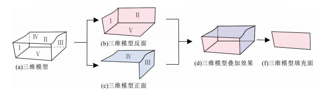
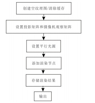
    In order to solve the problems of real-time, robustness and accuracy of the current profile generation, in this paper it proposes to solve the calculation bottleneck of the cutting problem from the perspective of image space by using the double stencil buffer technology. With the help of Render To Texture camera technology and high-resolution technology, the high-precision output of the profile under arbitrary route cutting is realized. Finally, the profile is vectorized to obtain the vector geological profile with attributes. Experiments show that the real-time generation technology of vector geological profile based on three-dimensional geological model is feasible. Compared with the traditional cutting, it is proved that our method has greatly improved the cutting efficiency, realizing the real-time generation of the profile and the exquisite and beautiful output of the vector profile. It provides a new idea for real-time profile generation based on three-dimensional geological model under the background of geological industry entering the era of three-dimensionalization, and achieves a multiplier effect.
    Automatic Lithology Classification Based on Deep Features Using Dual Polarization SAR Images
    Li Fasen, Li Xianju, Chen Weitao, Dong Yusen, Li Yuke, Wang Lizhe
    2022, 47(11): 4267-4279. doi: 10.3799/dqkx.2022.129
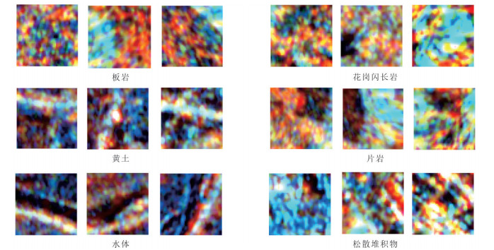
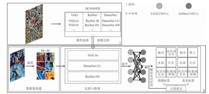
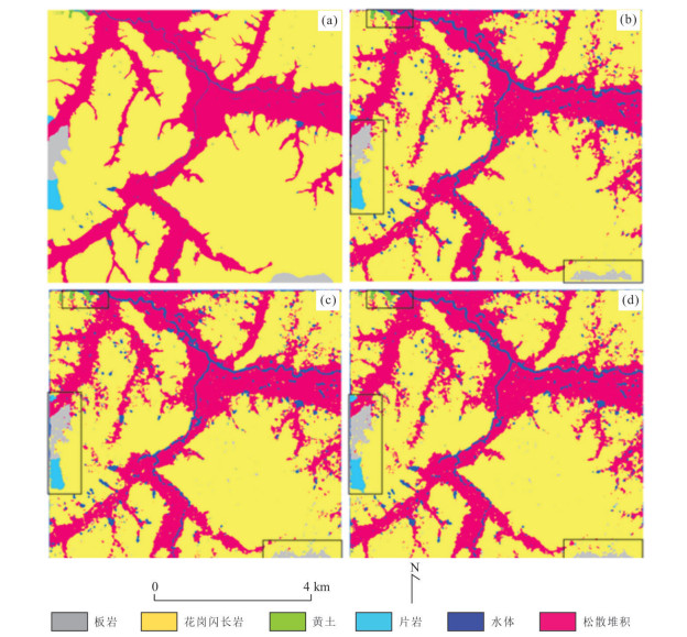
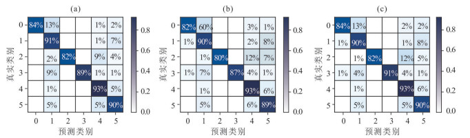
    Abstract:
    The lithology classification method based on pixel primitives, polarimetric synthetic aperture radar (SAR) data and traditional machine learning algorithm is easy to be affected by the inherent speckle noise, and the accuracy is not high. In order to reduce the effect of image noise, the neighborhood of large-scale pixels is considered as the primitive to characterize the spatial aggregation characteristics of surface geological units and the corresponding lithologic semantic information. Using GaoFen-3 dual polarization data, the polarization decomposition is carried out first, and a 3-channel color composite image is constructed as the input data of the subsequent model. Then, the deep convolutional neural network (DCNN) based migration learning method is used to extract the effective deep feature representation, so as to realize the automatic lithology classification under 5 m and 15 m spatial resolution conditions. The experiment results show that based on different resolution data and different DCNN algorithms, the total accuracy of automatic lithology classification is greater than 80%, and the highest accuracy is 91%. Generally, based on large-scale pixel neighborhood and DCNN migration learning method, high-precision lithology classification based on SAR data can be realized. The lithology remote sensing dataset based on dual polarization SAR created in this paper can also be used as the benchmark of lithology classification based on artificial intelligence.
    Constrained Inversion of Audio Magnetotelluric for Identifying Strata: A Case Study in Hami Basin
    Sun Hao, Liu Ying, Wang Zheng, Wang Zhen, Liu Jingping, Chen Chao, Wang Guocan, Wang An
    2022, 47(11): 4280-4293. 
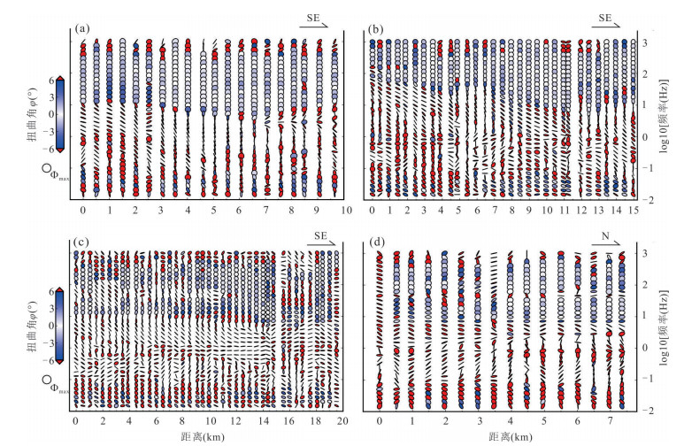
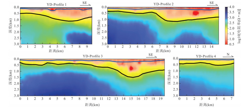
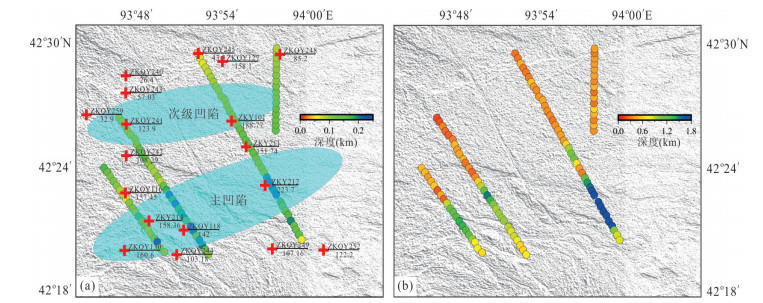
doi: 10.3799/dqkx.2022.207
    Abstract:
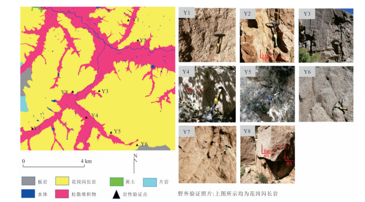
    Geological mapping on covered area is a crucial research of new geological mapping. Audio magnetotelluric (AMT) is one of effective geophysical methods for geological mapping on covered area, which can provide the constraint of electrical parameters for depicting strata and bedrocks. However, conventional AMT inversion cannot accurately describe the boundaries of electrical anomalies, and it is difficult to perform geological interpretation when there is no other geological and geophysical data constraints. Based on the feasibility of numerical simulation results and four AMT profiles in the Gobi desert area of Hami Yandun, it tries to investigate the availability of constrained AMT inversion in strata identification. Phase tensor analyses indicate that the shallow (< 1 Hz) electrical structure is mainly two-dimensional (2D), while the deep is affected by 3D structure. The resistivity is low in the shallow and gradually increases in the deep. The underground electrical structures of four profiles were obtained by 2D unconstrained inversion. Based on gravity anomalies, seismic interpretation results, physical properties of rocks and borehole data in the research area, the bottom interfaces of Oligocene-Miocene and Jurassic strata were preliminarily divided from the 2D inversion results. Furthermore, a prior model was established using the two interfaces, where the resistivity change ranges were set according to physical property data. Then, constrained AMT inversion was carried out. The better inversion results and the clear and reliable bottom interfaces of Oligocene-Miocene and Jurassic were obtained. Research results show that the resistivity of Oligocene-Miocene stratum is slightly smaller than 10 Ω•m and the bottom interface is shallow with an average depth of 120 m. The resistivity of Jurassic stratum is about 10-100 Ω•m and the bottom interface is deep up to 2 km. The buried depth of bedrock surface (Jurassic bottom interface) is deep in the southeast but shallow in the northwest, which indicates that the sedimentary center since Mesozoic is in the southeast of Hami Yandun area. Moreover, an angular unconformity exists between Jurassic and underlying Paleozoic strata. The study supports that Hami Yandun area may go through the extrusion from nearly NS compression stress since Cenozoic, resulting in the morphotectonic pattern of Jurassic uplift and depression with nearly EW or NEE direction in the central part. Besides, the angular unconformity beneath the Oligocene-Miocene strata may reflect the influence of later fold structure. This kind of fold structure along with uplift and depression might have the synsedimentary property.
    Origin and Geological Significance of Diabase Dikes from Hongge Layered Intrusion in Panxi Region
    Wang Kun, Li Qiwei, Qin Ying, Li Xiangbo, Dong Huan
    2022, 47(11): 4294-4308. doi: 10.3799/dqkx.2022.158
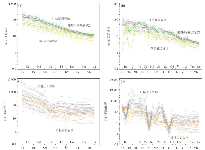
    Abstract:
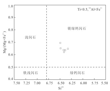
    In order to understand the evolution of the magmatic system of the Emeishan mantle plume, whole-rock major and trace elements, in-situ mineral composition and isotope studies as well as MELTS simulation were carried out on the diabase dikes in the Hongge giant Fe-Ti-V oxide deposit. The study shows that the Hongge diabases have consistent REE patterns and Sr-isotope compositions with the Emeishan high-Ti basalts, indicating that the diabases were derived from the Emeishan mantle plume. The Hongge diabases contain two generations of minerals, i.e., phenocryst and matrix. It is found that Mg# value of clinopyroxene varied continuously from the phenocryst core to rim and matrix, while the An values of plagioclase show an obvious discontinuity. The MELTS simulation results show that the composition variation could not be explained by a simple process of magma ascending, reflecting the basaltic magma may have mixed with the synchronous syenitic magma during the evolution process. Our research suggests that the Emeishan mantle plume magmatism is characterized by trans-crustal, poly-phase and multi-stage evolution, and "self-mixing" between co-genetic magmas is also nonnegligible.
    Organic Carbon Distribution Characteristics of Qingshankou Shale in Songliao Basin, China
    Wu Tiantian, Shang Fei, Chen Ruiqian, Zhong Zhi
    2022, 47(11): 4309-4318. doi: 10.3799/dqkx.2022.337
    Abstract:
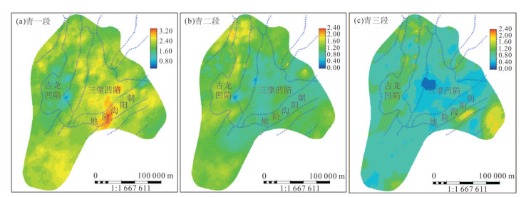
    Total organic carbon (TOC) content is one of the key parameters to evaluate shale oil and gas resources. In order to quantitatively evaluate the TOC distribution characteristics and predict the sweet spots of shale of Qingshankou Formation in Songliao basin, the three-dimensional (3D) structural model of the Qingshankou shale reservoir was firstly constructed based on the logging data. Then, vitrinite reflectance (Ro) was calculated by restoring the ancient burial depth of reservoir rocks, and the TOC content of the Qingshankou Formation was predicted using the ∆logR method. Finally, the 3D model of TOC content in Qingshankou Formation was built using the geostatistical method. The results show that, vertically, the TOC content of Qing 1 Member is in the range of 0%-4%. However, the TOC content of Qing 2 Member and Qing 3 Member is significantly lower than that of Qing 1 Member. Horizontally, the TOC content of Qing 1 Member in the south of Sanzhao sag and the middle of Chaoyanggou terrace is the highest. The TOC content of Qing 2 Member is lower than 2%, and that in the north part of Gulong sag is the highest. The TOC content of Qing 3 Member is generally lower than 1.4%. This work provides important guidance and reference for selecting favorable shale oil exploration and development areas in Songliao basin.
    Thermal Evolution History and Shale Gas Accumulation Significance of Lower Cambrian Qiongzhusi Formation in Southwest Sichuan Basin
    Rao Song, Yang Yinan, Hu Shengbiao, Wang Qiang
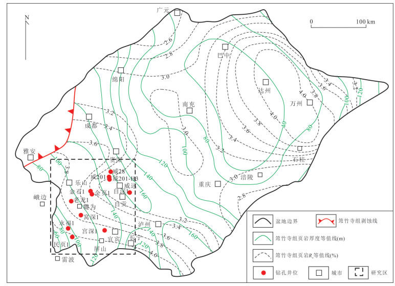
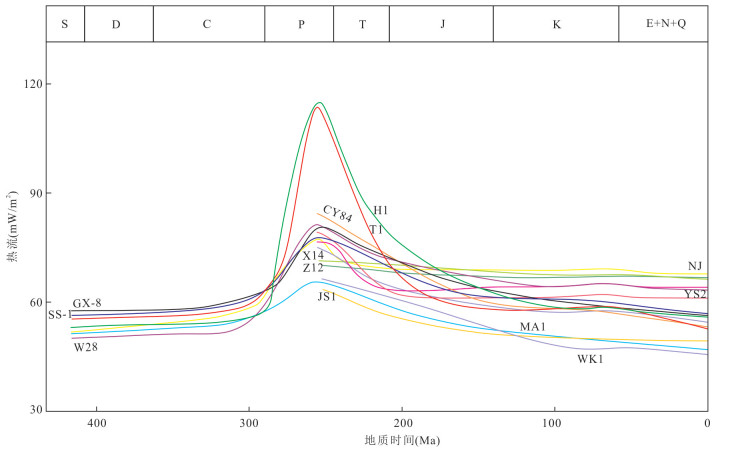
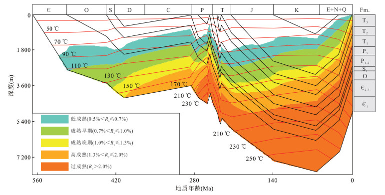
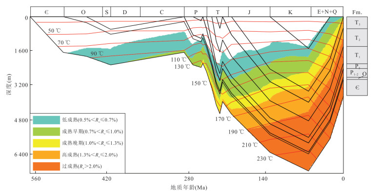
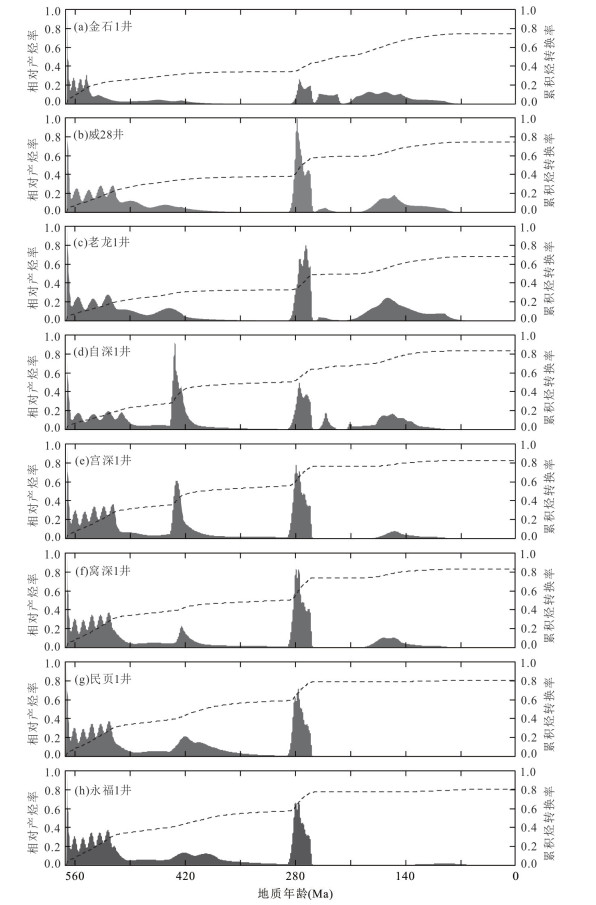
    2022, 47(11): 4319-4335. doi: 10.3799/dqkx.2022.153
    Abstract:
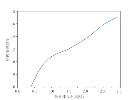
    The thermal evolution history is closely related to shale gas generation and accumulation process. On the one hand, the maturity evolution history determines the hydrocarbon generation process, type and amount of shale gas in the geological history. On the other hand, the formation of organic matter hosted pore is extremely relevant to the thermal evolution history of gas shale. In this paper, through analysis of burial and thermal history, it examined representative boreholes for the thermal evolution simulation of the Qiongzhusi Formation shale in the Southwest Sichuan basin, where the zircon (U-Th)/He and bitumen reflectance (Rb) were used for calibration. Then, the relationship between the thermal evolution history and the shale gas generation and accumulation was discussed. The results show that they differed from borehole to borehole on the thermal evolution and hydrocarbon generation history of Qiongzhusi Formation shale in the Southwest Sichuan basin and two patterns were summarized. The Qiongzhusi Formation shale in the Caledonian depression entered the mature stage during Caledonian period and typing stage during the Middle-Late Permian because of Emeishan mantle plume. Accordingly, the two hydrocarbon generation peaks occurred in the Silurian (oil and wet gas generation stage) and the Middle-Late Permian (dry gas generation stage), respectively, which indicates that the organic matter had been nearly exhausted during the Middle-Late Permian and there was no obvious hydrocarbon generating activities since then. The Qiongzhusi Formation shale in the Caledonian uplift area was very different from the former on the thermal evolution and hydrocarbon generation history. They had not yet or just exceeded the generation threshold during the Caledonian, and continually entered the mature and overmature stage during the late Hercynian to Yanshanian. There were also two rapid hydrocarbon generation stages of the Qiongzhusi Formation shale in the Caledonian uplift area, namely during the Middle-Late Permian (oil generation stage) and the Late Jurassic to Late Cretaceous (wet and dry gas generation stage). With the basin uplift and cooling, the hydrocarbon generation was effectively halted at the end of the Late Cretaceous. It shows that the different burial depths of Qiongzhusi Formation shale during the Middle-Late Permian caused dominantly the different influence by high heat flow associated with Emeishan mantle plume, and eventually led to the differences on the thermal evolution, hydrocarbon generation history and gas-bearing characteristics of Qiongzhusi Formation shale between the Caledonian depression and uplift area. The Qiongzhusi Formation shale gas accumulation process in Weiyuan-Qianwei area was divided into four phases on the basis of hydrocarbon generating and porosity evolution history analysis: the source-reservoir-cap deposition and biogenic gas accumulation stage during Early Paleozoic, the initial accumulation stage during the Middle-Late Permian, the main accumulation stage from the Late Jurassic to Early Cretaceous, and the adjustment stage since the Late Cretaceous. The thermal evolution analysis explains the Qiongzhusi Formation shale gas accumulation differences between the Weiyuan-Qianwei and periphery in the Southwest Sichuan basin.
    Scientific Problem(report review)
    What is the Occurrence State and Enrichment Mechanism of Key Metal Elements in Coal ?
    Yuan Jianjiang
    2022, 47(11): 4336-4338. doi: 10.3799/dqkx.2022.880
    Abstract: