2022 Vol. 47, No. 2
Display Method:
 PDF 813KB
2022, 47(2): 387-404.
doi: 10.3799/dqkx.2021.047
Abstract:
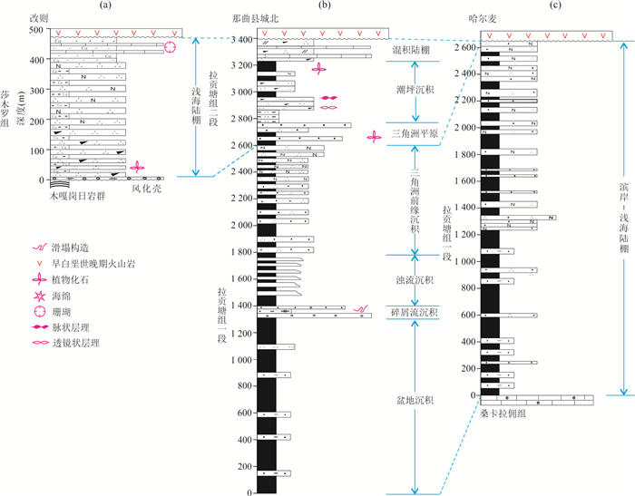
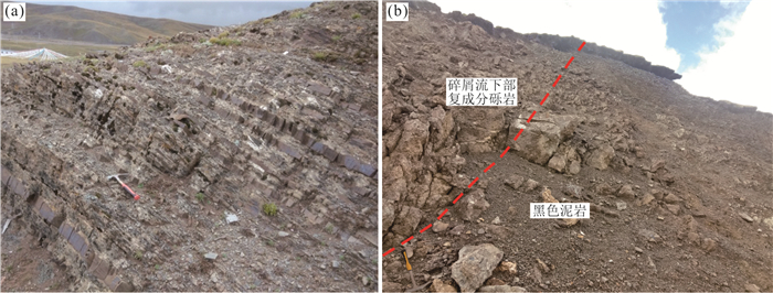
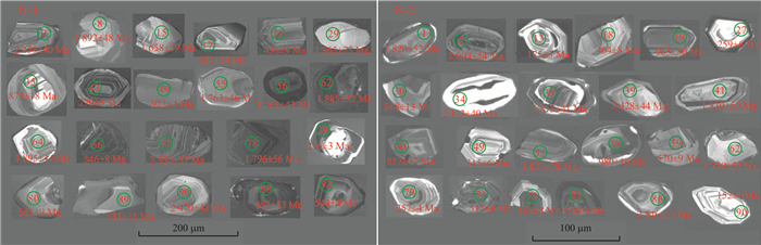
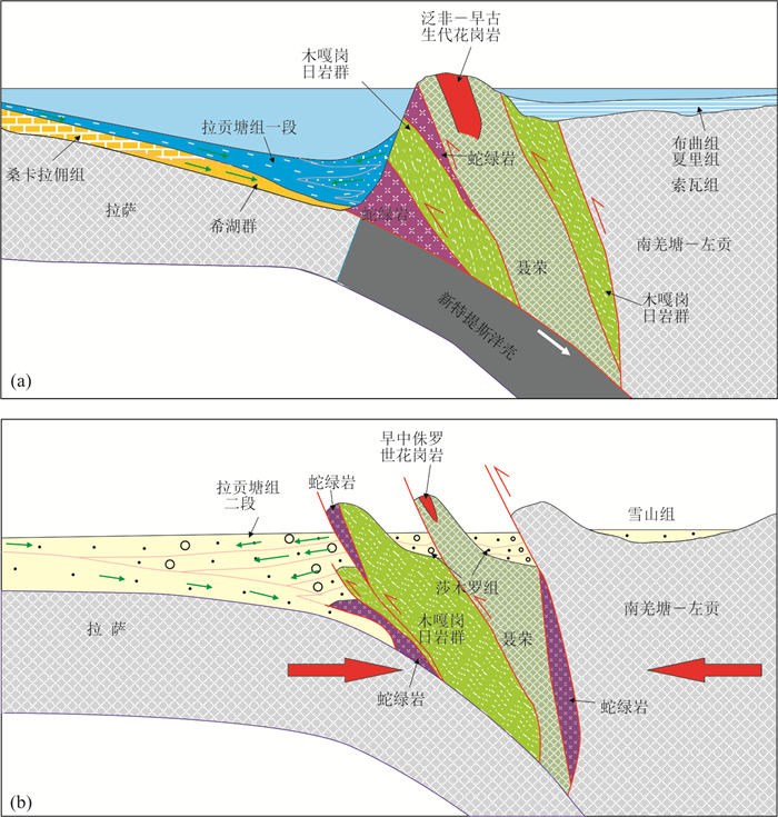
To identify its types and evolution features of the Mid-Late Jurassic basin located in northern margin of Lhasa block is of great significance for reconstructing its tectonic-paleogeography and assessing the petroliferous basins in Bangonghu-Nujiang junction zone and its adjacent area. In this paper, the sedimetary features and provenance area of Mid-Late Jurassic Lagongtang Fm which is exposed in north of Nagqu county, was studied. The results shows that the Member 1 of Lagongtang Fm belongs to steep-slope delta deposition, and debris flow deposits located in its lower part has the characterisitics of southward flow, and Member 2 of the Fm was deposted in tidal flats and mixed shelf, and the detrital zircon ages of greywackes in the lower part of Member 1 and quartz fine sandstone in the lower part of Member 2 range from 2 611 Ma to 216 Ma and from 2 800 Ma to 152 Ma respectively. Comprehensive research results shows that the basin located in northern marigin of Lhasa block is a peripheral foreland one controlled by Bangonghu-Nujiang junction zone, and had dual source supply, and experienced the conversion from flysch basin to molasses one at 152 Ma or so. Meanwhile, the overthrust which took place in Bangonghu-Nujiang junction zone become stronger than before since that time, and caused a new foreland basin marked by the Shamuluo Formation form in it.
To identify its types and evolution features of the Mid-Late Jurassic basin located in northern margin of Lhasa block is of great significance for reconstructing its tectonic-paleogeography and assessing the petroliferous basins in Bangonghu-Nujiang junction zone and its adjacent area. In this paper, the sedimetary features and provenance area of Mid-Late Jurassic Lagongtang Fm which is exposed in north of Nagqu county, was studied. The results shows that the Member 1 of Lagongtang Fm belongs to steep-slope delta deposition, and debris flow deposits located in its lower part has the characterisitics of southward flow, and Member 2 of the Fm was deposted in tidal flats and mixed shelf, and the detrital zircon ages of greywackes in the lower part of Member 1 and quartz fine sandstone in the lower part of Member 2 range from 2 611 Ma to 216 Ma and from 2 800 Ma to 152 Ma respectively. Comprehensive research results shows that the basin located in northern marigin of Lhasa block is a peripheral foreland one controlled by Bangonghu-Nujiang junction zone, and had dual source supply, and experienced the conversion from flysch basin to molasses one at 152 Ma or so. Meanwhile, the overthrust which took place in Bangonghu-Nujiang junction zone become stronger than before since that time, and caused a new foreland basin marked by the Shamuluo Formation form in it.


2022, 47(2): 405-417.
doi: 10.3799/dqkx.2021.087
Abstract:
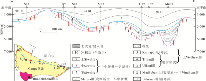
At present, the tectonosedimentary evolution since Proterozoic in Nepal and its southern adjacent area is still lacking of systematic research. In order to promote divisional geological understanding of the area, the author intends to combine the previous and the new research results to systematically summarize and discuss the tectonosedimentary evolution of the Lesser Himalaya of Nepal and its southern areas. The results show that, the tectonosedimentary evolution in the less Himalaya of Nepal and its southern areas are closely related to the northern part of the Indian shield in the geological history; since Proterozoic, it has experienced the following different stages of tectonic evolution in turn, that is from passive continental margin to intracontinental rift to passive continental margin to foreland basin; the Dailekh Group in western Nepal deposited in the passive continental margin before~1.8 Ga or before the pre-Columbia supercontinent; the Vindhyan supergroup deposited in an intracontinental rift(its lower part deposited in graben and its upper part deposited in depression), and the Lakharpata group in Nepal is equivalent to the lower Vindhyan group; the break-up of Gondwana supercontinent resulted in the formation of a series of rift basins with gradually late initial development time from north to south; the Surkhet Group and the Siwalik Group are deposited in passive continental margin to foreland basin, and the Swat/Subathu Formation of Surkhet Group is the last set of marine sedimentary strata in the geological history of the southern Himalayas, and it is also the key sedimentary response during the passive continental margin changing to the foreland basin; the large-scale molasse formation of the Siwalik Group marked the rapid and substantial uplift of the Himalayas, and after the group's sedimentation and diagenesis, the further compression of the Indo-Eurasian plate led to the last strong tectonic movement in geological history so far, forming the MFT and Siwalik fold belts, and forming the present tectonic framework of the Himalaya.
At present, the tectonosedimentary evolution since Proterozoic in Nepal and its southern adjacent area is still lacking of systematic research. In order to promote divisional geological understanding of the area, the author intends to combine the previous and the new research results to systematically summarize and discuss the tectonosedimentary evolution of the Lesser Himalaya of Nepal and its southern areas. The results show that, the tectonosedimentary evolution in the less Himalaya of Nepal and its southern areas are closely related to the northern part of the Indian shield in the geological history; since Proterozoic, it has experienced the following different stages of tectonic evolution in turn, that is from passive continental margin to intracontinental rift to passive continental margin to foreland basin; the Dailekh Group in western Nepal deposited in the passive continental margin before~1.8 Ga or before the pre-Columbia supercontinent; the Vindhyan supergroup deposited in an intracontinental rift(its lower part deposited in graben and its upper part deposited in depression), and the Lakharpata group in Nepal is equivalent to the lower Vindhyan group; the break-up of Gondwana supercontinent resulted in the formation of a series of rift basins with gradually late initial development time from north to south; the Surkhet Group and the Siwalik Group are deposited in passive continental margin to foreland basin, and the Swat/Subathu Formation of Surkhet Group is the last set of marine sedimentary strata in the geological history of the southern Himalayas, and it is also the key sedimentary response during the passive continental margin changing to the foreland basin; the large-scale molasse formation of the Siwalik Group marked the rapid and substantial uplift of the Himalayas, and after the group's sedimentation and diagenesis, the further compression of the Indo-Eurasian plate led to the last strong tectonic movement in geological history so far, forming the MFT and Siwalik fold belts, and forming the present tectonic framework of the Himalaya.


2022, 47(2): 418-436.
doi: 10.3799/dqkx.2021.097
Abstract:
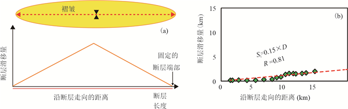
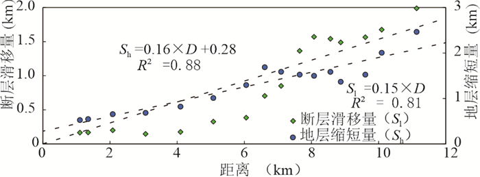
The specific neotectonic activities, spatial variations of erosion rates in Tianshan Mountains are led by the far-field effect of the India-Asia collision and variable precipitations. It is an ideal place to discuss the interaction of tectonic, surface processes and climatic change. The relationship of the amount of fault slip and topographic relief in this area might provide clues for understanding the interaction between tectonic and climate, and resulted topography. In this study, the subsurface three-dimensional structural geometry model of a fault-related anticline (Gumudi) at the western fault zone (Fukang) at the eastern Tianshan Mountains was constructed by the interpretation of the 3D seismic reflection data in depth. It shows that the dip of the fault is about 40°-50°, and fault-propagation folds developed. The tectonic deformation of this fault originated from the central zone and gradually propagated to the east and west ends. The amounts of the fault slip and the topographic relief at different areas were calculated from the subsurface three-dimensional tectonic structural geometry. The results show that the topographic relief (△H) is linearly related to the amount of fault slip (Sl). The maximum denudation, the maximum shortening, and the denudation rate are deduced to be as about 5.05 km, 9.20 km, and 0.38-0.60 mm/a, respectively, in the central area of the Fukang fault zone, which is based on the linear relationship between the faultslipandthetopographic relief. In addition, it presents a similar relationship that △H was equal to 1/10 Sl at different areas in spite of quite various dip angles of faults. This indicates that the relict topography is mainly controlled by the dynamic balance of the tectonic activities and erosion of the orogenic wedge rather than the magnitudes of the fault dip in this area.
The specific neotectonic activities, spatial variations of erosion rates in Tianshan Mountains are led by the far-field effect of the India-Asia collision and variable precipitations. It is an ideal place to discuss the interaction of tectonic, surface processes and climatic change. The relationship of the amount of fault slip and topographic relief in this area might provide clues for understanding the interaction between tectonic and climate, and resulted topography. In this study, the subsurface three-dimensional structural geometry model of a fault-related anticline (Gumudi) at the western fault zone (Fukang) at the eastern Tianshan Mountains was constructed by the interpretation of the 3D seismic reflection data in depth. It shows that the dip of the fault is about 40°-50°, and fault-propagation folds developed. The tectonic deformation of this fault originated from the central zone and gradually propagated to the east and west ends. The amounts of the fault slip and the topographic relief at different areas were calculated from the subsurface three-dimensional tectonic structural geometry. The results show that the topographic relief (△H) is linearly related to the amount of fault slip (Sl). The maximum denudation, the maximum shortening, and the denudation rate are deduced to be as about 5.05 km, 9.20 km, and 0.38-0.60 mm/a, respectively, in the central area of the Fukang fault zone, which is based on the linear relationship between the faultslipandthetopographic relief. In addition, it presents a similar relationship that △H was equal to 1/10 Sl at different areas in spite of quite various dip angles of faults. This indicates that the relict topography is mainly controlled by the dynamic balance of the tectonic activities and erosion of the orogenic wedge rather than the magnitudes of the fault dip in this area.


2022, 47(2): 437-451.
doi: 10.3799/dqkx.2021.073
Abstract:
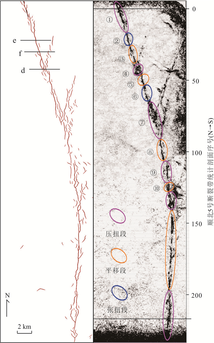
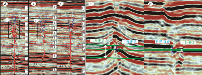
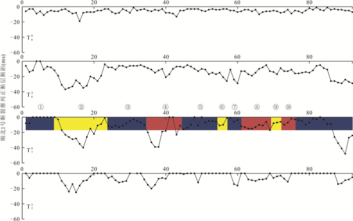
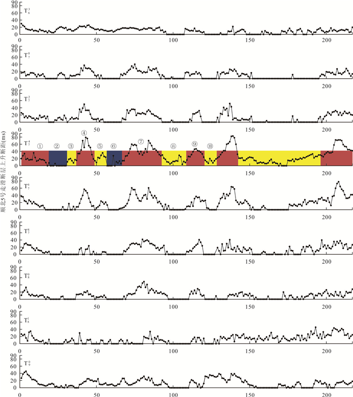
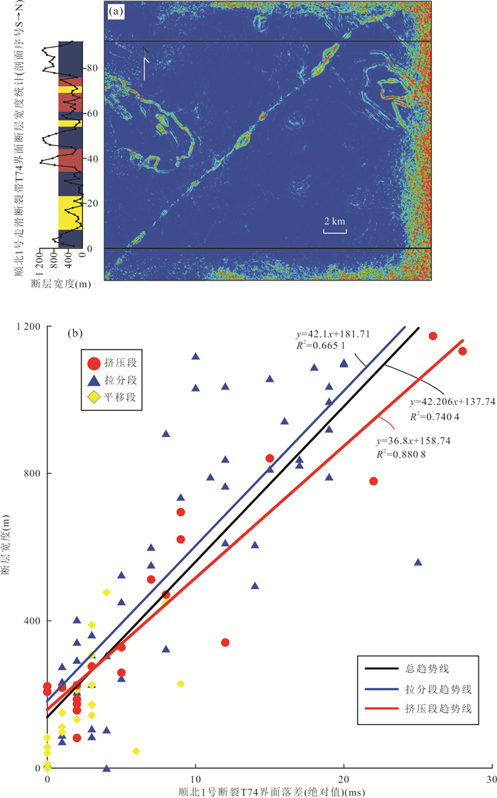
The Lower Paleozoic No.1 and No.5 strike-slip faults in Shunbei area of Tarim Basin are hot spots for oil and gas exploration at present. It is of great significance to characterize the structure of strike-slip fault zone for exploration and development. The vertical fault spacing and fault width of the Lower Paleozoic were calculated with 200 m vertical interval, and the quantitative relationship between the vertical fault spacing and fault width was established. The results showed that: (1) T74 is the main interface and top-down development in middle Caledonian Ⅲ episode of SB1 strike-slip faults; The en-echelon normal faults are mainly developed in T70 with bottom to top development. T74 is the main interface pressure ridge segment development activities during the middle Caledonian Ⅲ episode in SB5 faults, bottom-up inheritance deformation to T63 interface; In the late Caledonian period, the whole pull-apart activity occurred, and from the T70 interface, the main fault surface was connected with the pressure ridge structure in the form of graben structure and inherited. (2)There is a positive correlation between the vertical fault distance (x) and the fault damage zone width (y) of the strike-slip faults in Shunbei area. Shunbei No.1 fault: y=42.206x+137.74, R2=0.740 4;Shunbei No.5 fault: y=0.072 6x2+15.85x+196.95, R2=0.774 9.
The Lower Paleozoic No.1 and No.5 strike-slip faults in Shunbei area of Tarim Basin are hot spots for oil and gas exploration at present. It is of great significance to characterize the structure of strike-slip fault zone for exploration and development. The vertical fault spacing and fault width of the Lower Paleozoic were calculated with 200 m vertical interval, and the quantitative relationship between the vertical fault spacing and fault width was established. The results showed that: (1) T74 is the main interface and top-down development in middle Caledonian Ⅲ episode of SB1 strike-slip faults; The en-echelon normal faults are mainly developed in T70 with bottom to top development. T74 is the main interface pressure ridge segment development activities during the middle Caledonian Ⅲ episode in SB5 faults, bottom-up inheritance deformation to T63 interface; In the late Caledonian period, the whole pull-apart activity occurred, and from the T70 interface, the main fault surface was connected with the pressure ridge structure in the form of graben structure and inherited. (2)There is a positive correlation between the vertical fault distance (x) and the fault damage zone width (y) of the strike-slip faults in Shunbei area. Shunbei No.1 fault: y=42.206x+137.74, R2=0.740 4;Shunbei No.5 fault: y=0.072 6x2+15.85x+196.95, R2=0.774 9.


2022, 47(2): 452-463.
doi: 10.3799/dqkx.2020.234
Abstract:
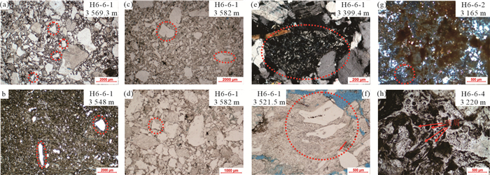
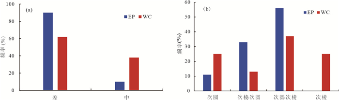
With increasing of the global energy consumption, the study of glutenite oil and gas reservoirs have been gradually deepened. Especially, significant discoveries of conglomeratic reservoirs have been made in the Mahu area, Junggar basin of Xinjiang, integrated condensate gas field of BZ19-6 in the offshore Bohai Bay Basin, and discovered over 10 billion cubic meters of gas in the H6-6 structure, Pearl River Mouth Basin, which making the glutenite reservoirs have become a new field of oil and gas exploration.The properties, distribution and sources of volcanic tuff in the glutenite reservoir and their effects on the reservoir physical properties and oil and gas properties were comprehensively characterized based on the thin section, scanning electron microscope and amplitude-variance seismic attribute grading-picking-fusion analysis. The results show that the dispersed distribution of volcanic tuff is the inherent reason of the Paleogene large-scale glutenite reservoir anomaly in the H6-6 structure. There are 3 craters in the Wenchang and Enping formations. The Wenchang volcanic activities continued to be intensive and were represented by magma overflow or explosive eruption of mafic and intermediate-felsic compositions. Most of the tuffaceous compositions are presented as the relatively coarse rock-fragments with the lack of fine-grained tuff filling pores. The Enping volcanic period was weakened with the intermediate-felsic magmatic explosive eruption. The intergranular pores are mostly filled with fine-grained tuffaceous compositions, which had obvious damage to the reservoir of oil and gas. As a whole, low tuffaceous contents are good for the preservation of reservoir pores. Systematic analysis of the genetic mechanism of the tuffaceous compositions in the glutenite reservoir is of theoretical significance to reveal the formation and evolution of the Paleogene Pearl River Mouth Basin, and it can also meet the exploration demands of large and medium-sized glutenite oil and gas reservoirs.
With increasing of the global energy consumption, the study of glutenite oil and gas reservoirs have been gradually deepened. Especially, significant discoveries of conglomeratic reservoirs have been made in the Mahu area, Junggar basin of Xinjiang, integrated condensate gas field of BZ19-6 in the offshore Bohai Bay Basin, and discovered over 10 billion cubic meters of gas in the H6-6 structure, Pearl River Mouth Basin, which making the glutenite reservoirs have become a new field of oil and gas exploration.The properties, distribution and sources of volcanic tuff in the glutenite reservoir and their effects on the reservoir physical properties and oil and gas properties were comprehensively characterized based on the thin section, scanning electron microscope and amplitude-variance seismic attribute grading-picking-fusion analysis. The results show that the dispersed distribution of volcanic tuff is the inherent reason of the Paleogene large-scale glutenite reservoir anomaly in the H6-6 structure. There are 3 craters in the Wenchang and Enping formations. The Wenchang volcanic activities continued to be intensive and were represented by magma overflow or explosive eruption of mafic and intermediate-felsic compositions. Most of the tuffaceous compositions are presented as the relatively coarse rock-fragments with the lack of fine-grained tuff filling pores. The Enping volcanic period was weakened with the intermediate-felsic magmatic explosive eruption. The intergranular pores are mostly filled with fine-grained tuffaceous compositions, which had obvious damage to the reservoir of oil and gas. As a whole, low tuffaceous contents are good for the preservation of reservoir pores. Systematic analysis of the genetic mechanism of the tuffaceous compositions in the glutenite reservoir is of theoretical significance to reveal the formation and evolution of the Paleogene Pearl River Mouth Basin, and it can also meet the exploration demands of large and medium-sized glutenite oil and gas reservoirs.


2022, 47(2): 464-478.
doi: 10.3799/dqkx.2021.099
Abstract:
The lagging effect of oil and gas migration refers to the phenomenon that the oil and gas generated and discharged from the source rock too early but accumulated too late, so the oil and gas experienced long-term and long-distance migration, resulting in the phase state and maturity of the accumulated reservoir being lower than that from the current source rock. This lagging effect of hydrocarbon migration is common in Cenozoic continental rift basins in eastern China, especially in slope zone. By means of geochemical analysis, balanced section technique, basin simulation and inclusion analysis, this paper studies the spatiotemporal coupling relationship of various reservoir forming factors in Laizhouwan Sag, Bohai Sea, It is show that there are obvious oil and gas migration lagging effect and ultra-late hydrocarbon accumulation in the study area. The source rocks of the Sha4 formation have entered the hydrocarbon expulsion period during the middle-late Dongying Formation, while the shallow traps were formed in the Neotectonic movement period, and the main hydrocarbon filling period is from 2 Ma to now; the oil and gas accumulation time that near northern depression is early, while the structures that far away from northern depression is late, the deep strata is early, while the shallow strata is late. In addition, this paper also discusses the causes of the oil and gas migration's lagging effect. It is considered that tectonic movement controls the process of hydrocarbon generation and expulsion and the vertical migration of oil and gas, the principle of oil and gas differential accumulation controls the sequence of oil and gas charging, and the movement of overpressure blocking fluid developed in the source rock section is the main factors for the lagging effect of oil and gas migration.
The lagging effect of oil and gas migration refers to the phenomenon that the oil and gas generated and discharged from the source rock too early but accumulated too late, so the oil and gas experienced long-term and long-distance migration, resulting in the phase state and maturity of the accumulated reservoir being lower than that from the current source rock. This lagging effect of hydrocarbon migration is common in Cenozoic continental rift basins in eastern China, especially in slope zone. By means of geochemical analysis, balanced section technique, basin simulation and inclusion analysis, this paper studies the spatiotemporal coupling relationship of various reservoir forming factors in Laizhouwan Sag, Bohai Sea, It is show that there are obvious oil and gas migration lagging effect and ultra-late hydrocarbon accumulation in the study area. The source rocks of the Sha4 formation have entered the hydrocarbon expulsion period during the middle-late Dongying Formation, while the shallow traps were formed in the Neotectonic movement period, and the main hydrocarbon filling period is from 2 Ma to now; the oil and gas accumulation time that near northern depression is early, while the structures that far away from northern depression is late, the deep strata is early, while the shallow strata is late. In addition, this paper also discusses the causes of the oil and gas migration's lagging effect. It is considered that tectonic movement controls the process of hydrocarbon generation and expulsion and the vertical migration of oil and gas, the principle of oil and gas differential accumulation controls the sequence of oil and gas charging, and the movement of overpressure blocking fluid developed in the source rock section is the main factors for the lagging effect of oil and gas migration.


2022, 47(2): 479-489.
doi: 10.3799/dqkx.2021.071
Abstract:
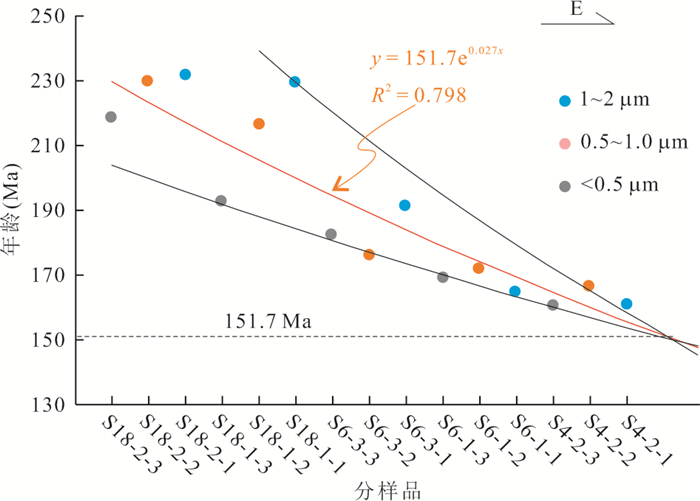
For determining the hydrocarbon accumulation ages of Sulige gas field in the Ordos basin, pore-filling clay materials were extracted from reservoir sandstones and separated into frictions of < 0.5, 0.5-1.0 and 1.0-2.0 μm, then 40Ar-39Ar dating of illite was dealt with laser step-heating. The isochron age is a mixed age of authigenic illite and detrital illite. Through trend analysis and regression analysis, minimum trend age and minimum regression age are obtained, which are more close to authigenic illite ages. The result shows that the isochron ages of illite minerals range from 163.1 Ma to 224.3 Ma, which are the mixed ages of authigenic illite and detrital illite. Based on mathematical statistics method, the minimum trend age and the minimum regression age are extrapolated to be 151.7 Ma and 152.4 Ma, respectively, which are supposed to be more close to authigenic illite ages, representing the time of thermal fluid activity and hydrocarbon accumulation.
For determining the hydrocarbon accumulation ages of Sulige gas field in the Ordos basin, pore-filling clay materials were extracted from reservoir sandstones and separated into frictions of < 0.5, 0.5-1.0 and 1.0-2.0 μm, then 40Ar-39Ar dating of illite was dealt with laser step-heating. The isochron age is a mixed age of authigenic illite and detrital illite. Through trend analysis and regression analysis, minimum trend age and minimum regression age are obtained, which are more close to authigenic illite ages. The result shows that the isochron ages of illite minerals range from 163.1 Ma to 224.3 Ma, which are the mixed ages of authigenic illite and detrital illite. Based on mathematical statistics method, the minimum trend age and the minimum regression age are extrapolated to be 151.7 Ma and 152.4 Ma, respectively, which are supposed to be more close to authigenic illite ages, representing the time of thermal fluid activity and hydrocarbon accumulation.


2022, 47(2): 490-504.
doi: 10.3799/dqkx.2021.076
Abstract:
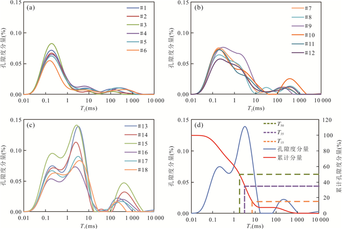
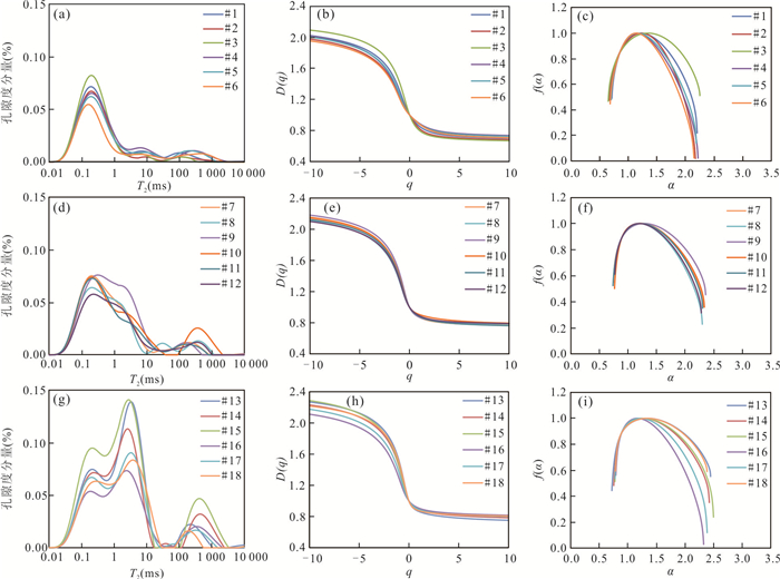
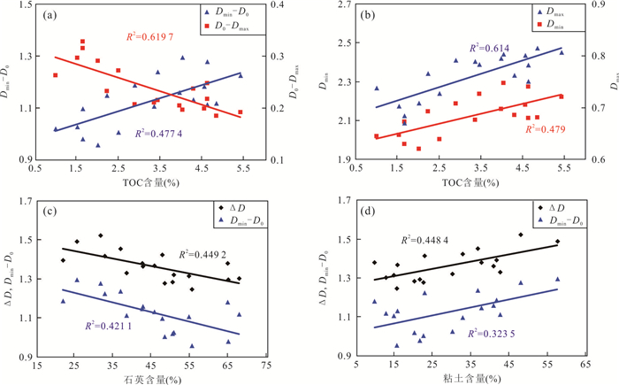
Select the organic-rich shale of the Wufeng Formation-sublayers Long-11 in western Chongqing to carry out field emission scanning electron microscopy, nuclear magnetic resonance and X-ray diffraction experiments. Based on image processing and multifractal theory, the pore structure of the shale reservoir was analyzed. Characteristics and heterogeneity. The results show that: (1) Scanning electron microscopy analysis shows that the average pore size of organic pores in the study area is too small. The number of organic pores < 50 nm accounted for 82%, and the number of organic pores >100 nm accounted for 52%; (2)According to the NMR T2 spectrum peak shape, it is divided into categories Ⅰ~Ⅲ, which are single-peak, double-peak and three-peak respectively. The shale reservoir of type Ⅲ has larger pore size and porosity, and has better storage conditions and seepage capacity; (3)Based on the multifractal theory to characterize the heterogeneity of the reservoir, the higher the quartz content, the lower the clay content, the weaker the heterogeneity, which in turn controls the porosity and permeability. The relationship between multifractal parameters and mineral components and physical property parameters effectively characterizes the pore structure of the reservoir and provides a new perspective for the evaluation of its heterogeneity.
Select the organic-rich shale of the Wufeng Formation-sublayers Long-11 in western Chongqing to carry out field emission scanning electron microscopy, nuclear magnetic resonance and X-ray diffraction experiments. Based on image processing and multifractal theory, the pore structure of the shale reservoir was analyzed. Characteristics and heterogeneity. The results show that: (1) Scanning electron microscopy analysis shows that the average pore size of organic pores in the study area is too small. The number of organic pores < 50 nm accounted for 82%, and the number of organic pores >100 nm accounted for 52%; (2)According to the NMR T2 spectrum peak shape, it is divided into categories Ⅰ~Ⅲ, which are single-peak, double-peak and three-peak respectively. The shale reservoir of type Ⅲ has larger pore size and porosity, and has better storage conditions and seepage capacity; (3)Based on the multifractal theory to characterize the heterogeneity of the reservoir, the higher the quartz content, the lower the clay content, the weaker the heterogeneity, which in turn controls the porosity and permeability. The relationship between multifractal parameters and mineral components and physical property parameters effectively characterizes the pore structure of the reservoir and provides a new perspective for the evaluation of its heterogeneity.


2022, 47(2): 505-517.
doi: 10.3799/dqkx.2021.053
Abstract:
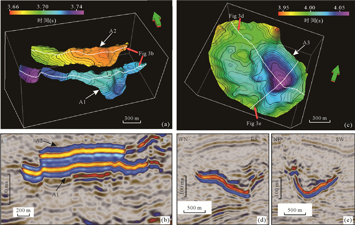
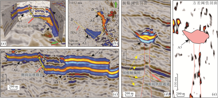
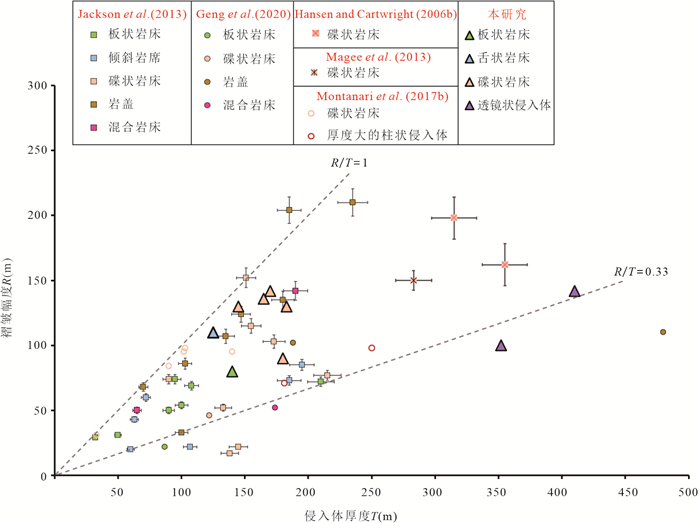
A large number of Early Miocene (ca. 15.5Ma) shallow igneous intrusions(intrusion depths < 3 000 m) have been identified in the Baiyun Sag of Pearl River Mouth Basin. Their morphological characteristics, relationships and forced folds above them have not been systematically studied. This paper detailedly describes the shapes, vertical migration pathways and spatial relationships (sill complexes) of igneous intrusions, using high-resolution 3D seismic data. Moreover, the geomorphological relationship between the forced folds and the intrusions are quantitatively analyzed. The igneous intrusions are characterized by saucer, strata-concordant, tongue orlentoid shapes. The source and flow direction of magma could be indicated from the geomorphological characteristics and spatial relationship of sills. Magma emplacement is transported from adjacent sills(lateral supply) or from dykes(vertical supply).The geomorphological characteristics of igneous intrusion are mainly controlled by the viscosity of magma, the cohesion of host rock and the emplacement depth of magma. Moreover, some igneous intrusions could trigger sediment deformations of overlying strata and form forced folds. The amplitudes of forced folds are usually less than the thickness of the igneous intrusion, because of the plastic deformation. These folds could serve as hydrocarbon traps whose sizes are mainly influenced by the scale and thickness of underlying igneous intrusion. Furthermore, normal faults that are located within the folded strata and generated by differential compaction provide pathways for vertical hydrocarbon migration.
A large number of Early Miocene (ca. 15.5Ma) shallow igneous intrusions(intrusion depths < 3 000 m) have been identified in the Baiyun Sag of Pearl River Mouth Basin. Their morphological characteristics, relationships and forced folds above them have not been systematically studied. This paper detailedly describes the shapes, vertical migration pathways and spatial relationships (sill complexes) of igneous intrusions, using high-resolution 3D seismic data. Moreover, the geomorphological relationship between the forced folds and the intrusions are quantitatively analyzed. The igneous intrusions are characterized by saucer, strata-concordant, tongue orlentoid shapes. The source and flow direction of magma could be indicated from the geomorphological characteristics and spatial relationship of sills. Magma emplacement is transported from adjacent sills(lateral supply) or from dykes(vertical supply).The geomorphological characteristics of igneous intrusion are mainly controlled by the viscosity of magma, the cohesion of host rock and the emplacement depth of magma. Moreover, some igneous intrusions could trigger sediment deformations of overlying strata and form forced folds. The amplitudes of forced folds are usually less than the thickness of the igneous intrusion, because of the plastic deformation. These folds could serve as hydrocarbon traps whose sizes are mainly influenced by the scale and thickness of underlying igneous intrusion. Furthermore, normal faults that are located within the folded strata and generated by differential compaction provide pathways for vertical hydrocarbon migration.


2022, 47(2): 518-531.
doi: 10.3799/dqkx.2021.049
Abstract:
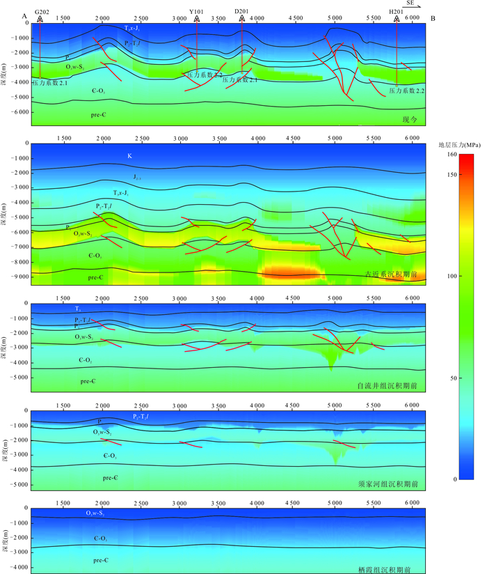
Fluid activity and pressure evolution are important indicators for shale gas enrichment or destruction. Based on core observation and petrographic method, the mineral filling sequence of Wufeng-Longmaxi shales in Ningxi and Luzhou area, southern Sichuan Basin is determined. On this basis, combined with fluid inclusion tests, the stages and characteristics of fluid activities in the reservoir are analyzed. Finally, Basin Modeling is used to recover the evolution of formation pressure under complex structural background. The results show that fractures are mainly filled with calcite, and quartz is found in some veins. Abundant hydrocarbon bearing inclusions are observed in vein minerals, including yellow or blue fluorescent gas-liquid hydrocarbon inclusions, black bitumen inclusions and natural gas inclusions. At least two phases of fluid filling have been detected in both Ningxi Block and Luzhou Block, including one stage of oil filling in Late Permian to Early Triassic and one stage of natural gas filling in Jurassic. Before Paleogene deposition, the formation pressure coefficient of Wufeng-Longmaxi Formation had reached the maximum value. The main fault in Luzhou Block did not cut through the regional cap rock, and the amount of uplift and erosion in Late Cenozoic was relatively low. Therefore, the overall preservation conditions of Luzhou Block are good, and the current pressure coefficient is above 2.0. However, the main fault in Ningxi Block was activated and cut through the regional cap rock during the late Indosinian-Yanshanian movements, and was obviously reformed by Cenozoic tectonic uplift and denudation, resulting in overpressure release.
Fluid activity and pressure evolution are important indicators for shale gas enrichment or destruction. Based on core observation and petrographic method, the mineral filling sequence of Wufeng-Longmaxi shales in Ningxi and Luzhou area, southern Sichuan Basin is determined. On this basis, combined with fluid inclusion tests, the stages and characteristics of fluid activities in the reservoir are analyzed. Finally, Basin Modeling is used to recover the evolution of formation pressure under complex structural background. The results show that fractures are mainly filled with calcite, and quartz is found in some veins. Abundant hydrocarbon bearing inclusions are observed in vein minerals, including yellow or blue fluorescent gas-liquid hydrocarbon inclusions, black bitumen inclusions and natural gas inclusions. At least two phases of fluid filling have been detected in both Ningxi Block and Luzhou Block, including one stage of oil filling in Late Permian to Early Triassic and one stage of natural gas filling in Jurassic. Before Paleogene deposition, the formation pressure coefficient of Wufeng-Longmaxi Formation had reached the maximum value. The main fault in Luzhou Block did not cut through the regional cap rock, and the amount of uplift and erosion in Late Cenozoic was relatively low. Therefore, the overall preservation conditions of Luzhou Block are good, and the current pressure coefficient is above 2.0. However, the main fault in Ningxi Block was activated and cut through the regional cap rock during the late Indosinian-Yanshanian movements, and was obviously reformed by Cenozoic tectonic uplift and denudation, resulting in overpressure release.


2022, 47(2): 532-543.
doi: 10.3799/dqkx.2021.165
Abstract:
The Middle Jurassic Xinshanyao Formation yields abundant and diverse fossil Ginkgophytes in the Shaerhu Coalfield of Xinjiang, NW China. Four leaf compression fossil of Phoenicopsis angustifolia Heer were selected from this horizon for calculating the epidermal stomatal parameters and their isotope carbon composition of leaf cuticles. On this basis, the Middle Jurassic (Aalenian-Bajocian) paleo-atmospheric CO2 concentration, paleo-temperature, and paleo-altitude of Shaerhu region of were tentatively reconstructed. Additionally, the water use efficiency of the current Ph. angustifolia was also calculated. The results show that the average stomatal index (SI) of Phoenicopsis angustifolia Heer is 5.90%. The paleo-atmospheric CO2 concentration obtained by the stomatal ratio method is (1 240.16±122.75)×10-6, which is within the credible error range of the GEOCARB Ⅲ. The average value of the stable carbon isotope δ13Cp of plant fossils is -23.07‰, and its water use efficiency (WUE) is calculated to be 272.06 mmol/mol. The paleo-average temperature of Shaerhu is about 16.8~20.7℃, the paleo-altitude is 196.7 m, which generally reflects Shaerhu Coalfield was a kind of environment with high CO2 concentration, warm and humid climate in the early Middle Jurassic.
The Middle Jurassic Xinshanyao Formation yields abundant and diverse fossil Ginkgophytes in the Shaerhu Coalfield of Xinjiang, NW China. Four leaf compression fossil of Phoenicopsis angustifolia Heer were selected from this horizon for calculating the epidermal stomatal parameters and their isotope carbon composition of leaf cuticles. On this basis, the Middle Jurassic (Aalenian-Bajocian) paleo-atmospheric CO2 concentration, paleo-temperature, and paleo-altitude of Shaerhu region of were tentatively reconstructed. Additionally, the water use efficiency of the current Ph. angustifolia was also calculated. The results show that the average stomatal index (SI) of Phoenicopsis angustifolia Heer is 5.90%. The paleo-atmospheric CO2 concentration obtained by the stomatal ratio method is (1 240.16±122.75)×10-6, which is within the credible error range of the GEOCARB Ⅲ. The average value of the stable carbon isotope δ13Cp of plant fossils is -23.07‰, and its water use efficiency (WUE) is calculated to be 272.06 mmol/mol. The paleo-average temperature of Shaerhu is about 16.8~20.7℃, the paleo-altitude is 196.7 m, which generally reflects Shaerhu Coalfield was a kind of environment with high CO2 concentration, warm and humid climate in the early Middle Jurassic.


2022, 47(2): 544-555.
doi: 10.3799/dqkx.2021.108
Abstract:
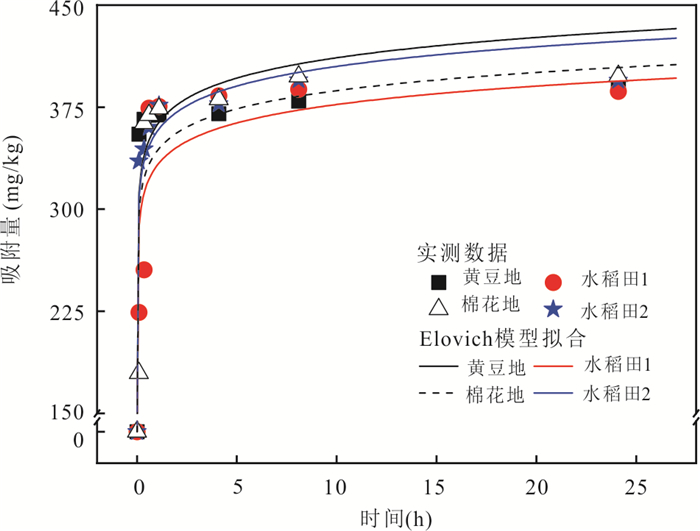
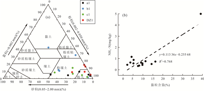
In order to reveal the adsorption and desorption characteristics of Cd2+ in upland and paddy soil, the soil of soybean field, cotton field and rice field in Jianghan Plain were taken as the research objects to carry out the adsorption kinetics experiment, isothermal adsorption desorption experiment and influence experiment of organic matter on soil Cd2+.The results showed that: the adsorption of Cd2+ by soil in Jianghan Plain was a complex adsorption kinetic process, and was dominated by chemisorption. The initial adsorption rate of Cd2+ in paddy soil was higher than that in dryland soil; while dryland soil had lower adsorption capacity and higher desorption capacity for Cd2+, paddy soil had higher adsorption capacity and lower desorption energy for Cd2+.This is related to soil properties such as organic matter content, Cd2+ background content and soil clay content. After removing organic matter, the adsorption capacity of Cd2+ in upland and paddy soil decreased significantly. The adsorption capacity of Cd2+ in paddy soil was still higher than that in upland soil after the removal of organic matter. The research in this paper can provide a theoretical basis for the remediation of Cd2+ pollution in different types of farmland soils.
In order to reveal the adsorption and desorption characteristics of Cd2+ in upland and paddy soil, the soil of soybean field, cotton field and rice field in Jianghan Plain were taken as the research objects to carry out the adsorption kinetics experiment, isothermal adsorption desorption experiment and influence experiment of organic matter on soil Cd2+.The results showed that: the adsorption of Cd2+ by soil in Jianghan Plain was a complex adsorption kinetic process, and was dominated by chemisorption. The initial adsorption rate of Cd2+ in paddy soil was higher than that in dryland soil; while dryland soil had lower adsorption capacity and higher desorption capacity for Cd2+, paddy soil had higher adsorption capacity and lower desorption energy for Cd2+.This is related to soil properties such as organic matter content, Cd2+ background content and soil clay content. After removing organic matter, the adsorption capacity of Cd2+ in upland and paddy soil decreased significantly. The adsorption capacity of Cd2+ in paddy soil was still higher than that in upland soil after the removal of organic matter. The research in this paper can provide a theoretical basis for the remediation of Cd2+ pollution in different types of farmland soils.


2022, 47(2): 556-567.
doi: 10.3799/dqkx.2021.037
Abstract:
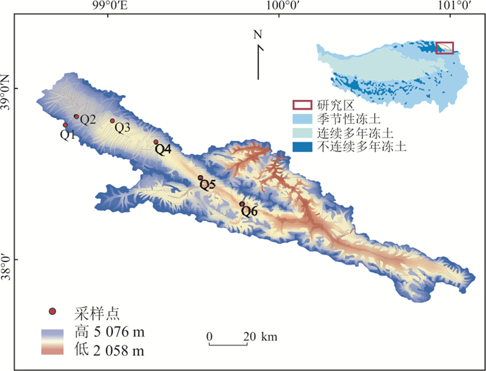
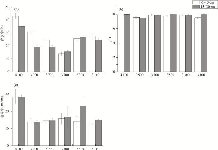
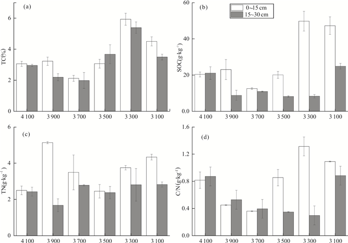
Global warming may cause the decomposition of organic carbon in permafrost regions and release methane (CH4) into the atmosphere, while the correlation between methane fluxes in permafrost regions and the structure of methane-related microbes and the abundance of functional genes remains unclear. In this study, we selected the permafrost region of the Qilian Mountains in the northern Qinghai-Tibet Plateau, and the field work was conducted from June 2019 to January 2020. The CH4 fluxes were measured at different altitudes using static chamber-gas chromatography. The soil physical and chemical variables and abundances of CH4 function genes were analyzed. The results show that the methane fluxes largely increased with the altitude. It appeared as a source at 4 100 m and 3 900 m, while other altitude areas appear as carbon sinks. The soil moisture content, conductivity and mcrA gene abundance were positively correlated with CH4 fluxes. The results showed that CH4 flux at different altitudes in the permafrost regions of Qilian Mountains were affected by soil moisture content and mcrA gene abundance, while organic carbon content mainly affected microbial diversity.
Global warming may cause the decomposition of organic carbon in permafrost regions and release methane (CH4) into the atmosphere, while the correlation between methane fluxes in permafrost regions and the structure of methane-related microbes and the abundance of functional genes remains unclear. In this study, we selected the permafrost region of the Qilian Mountains in the northern Qinghai-Tibet Plateau, and the field work was conducted from June 2019 to January 2020. The CH4 fluxes were measured at different altitudes using static chamber-gas chromatography. The soil physical and chemical variables and abundances of CH4 function genes were analyzed. The results show that the methane fluxes largely increased with the altitude. It appeared as a source at 4 100 m and 3 900 m, while other altitude areas appear as carbon sinks. The soil moisture content, conductivity and mcrA gene abundance were positively correlated with CH4 fluxes. The results showed that CH4 flux at different altitudes in the permafrost regions of Qilian Mountains were affected by soil moisture content and mcrA gene abundance, while organic carbon content mainly affected microbial diversity.


2022, 47(2): 568-576.
doi: 10.3799/dqkx.2021.036
Abstract:
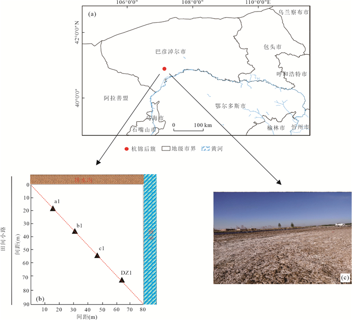
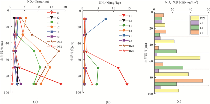
Soil nitrogen plays an important role in plant growth, soil physicochemical properties and microbial activities. In order to identify the process and mechanism of nitrogen migration in the unsaturated zone in salinized areas, a typical salinized farmland in Hetao irrigation areawas selected to explore the difference of nitrogen distribution in soil profiles and the main influencing factors through monitoring the unsaturated zone and hydrochemical statistical analysis. The results showed that the soil nitrogen content in the 0-100 cm depth of the study area was at a low level, and the average contents of NO3-N, NH4-N and NO2-N were 4.88, 1.63 and 0.04 mg/kg, respectively. The spatial distribution of soil nitrogen is related to soil depth and physical and chemical properties. With the increase of soil depth, NO3-N content showed a trend of gradual increase. The high value area is mainly distributed in the soil layer with a depth of 40-80 cm, and the content of NH4-N mostly concentrates in the soil layer with a depth of 60-100 cm. Soil NO3-N content is mainly related to soil pH, water content and water-soluble salt content (TDS, Cl-, SO42-、Na+), while NH4-N content is mainly affected by water content, clay particles and TOC content. The accumulation of NO3-N and NH4-N in soil is related to the movement of water and salt, the electrostatic adsorption of soil minerals and the control of microorganisms, which are largely affected by soil particle size composition, pH, organic matter content and competitive anionsand cations content.
Soil nitrogen plays an important role in plant growth, soil physicochemical properties and microbial activities. In order to identify the process and mechanism of nitrogen migration in the unsaturated zone in salinized areas, a typical salinized farmland in Hetao irrigation areawas selected to explore the difference of nitrogen distribution in soil profiles and the main influencing factors through monitoring the unsaturated zone and hydrochemical statistical analysis. The results showed that the soil nitrogen content in the 0-100 cm depth of the study area was at a low level, and the average contents of NO3-N, NH4-N and NO2-N were 4.88, 1.63 and 0.04 mg/kg, respectively. The spatial distribution of soil nitrogen is related to soil depth and physical and chemical properties. With the increase of soil depth, NO3-N content showed a trend of gradual increase. The high value area is mainly distributed in the soil layer with a depth of 40-80 cm, and the content of NH4-N mostly concentrates in the soil layer with a depth of 60-100 cm. Soil NO3-N content is mainly related to soil pH, water content and water-soluble salt content (TDS, Cl-, SO42-、Na+), while NH4-N content is mainly affected by water content, clay particles and TOC content. The accumulation of NO3-N and NH4-N in soil is related to the movement of water and salt, the electrostatic adsorption of soil minerals and the control of microorganisms, which are largely affected by soil particle size composition, pH, organic matter content and competitive anionsand cations content.


2022, 47(2): 577-588.
doi: 10.3799/dqkx.2021.028
Abstract:
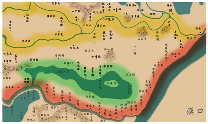
Wuhan is located on the confluence of the Yangtze and Han river in the middle reaches of the Yangtze River. Wuhan is known as "River City" and "City with hundreds of lakes" because of dense river network and numerous lakes in Wuhan. The lakes in Wuhan are of great significance to the sustainable development of Wuhan and the construction of livable city. Many studies have been carried out on the lakes in Wuhan, but few on factors controlling formation of the lakes. The study of genesis of lakes is not only great significance to the Wuhan's modern geoenvironmental evolution but also is a basic scientific issue of lake protection. Based on geological and geomorphic survey, a comprehensive study was carried out on the evolution of river and lake palaeogeography and the historical literature records and so on. The results suggest that the formation of the lakes in Wuhan is closely related to river geological process. And the lakes in Wuhan can be divided into four types based on cause of lake formation: Oxbow lakes (also called abandoned channel lake and lake bounded by a channel and a shoal), bank burst lake, interfluvial depression lake and valley barrier lake. Based on the characteristics, geomorphic distribution and formation process of all types of lakes, we suggest that valley barrier lake is the main type of lakes inWuhan and that its formation and evolution are closely related to the interaction between river and sea controlled by climate change. The valley barrier lakes have experienced three stages: lake basin formation (20-14 ka), lake formation (14-7 ka) and lake development (since 7 ka). In addition, Wuhan has experienced the development process from "the lakes encircling a city" to "the city surrounding lakes". The reclamation of the lakes is the most important man-made natural reconstruction project in Wuhan, which is also the main cause of the tension between man and land at present. The major lakes in Hankou area are interfluvial depression lake. The mode of filling development of these lakes is "Dike-Draining-Land". The lakes in Wuchang and Hanyang areas are dominated by valley barrier lakes. The mode of lake surrounding development of these lake is "Lake branches filling and Land forming".
Wuhan is located on the confluence of the Yangtze and Han river in the middle reaches of the Yangtze River. Wuhan is known as "River City" and "City with hundreds of lakes" because of dense river network and numerous lakes in Wuhan. The lakes in Wuhan are of great significance to the sustainable development of Wuhan and the construction of livable city. Many studies have been carried out on the lakes in Wuhan, but few on factors controlling formation of the lakes. The study of genesis of lakes is not only great significance to the Wuhan's modern geoenvironmental evolution but also is a basic scientific issue of lake protection. Based on geological and geomorphic survey, a comprehensive study was carried out on the evolution of river and lake palaeogeography and the historical literature records and so on. The results suggest that the formation of the lakes in Wuhan is closely related to river geological process. And the lakes in Wuhan can be divided into four types based on cause of lake formation: Oxbow lakes (also called abandoned channel lake and lake bounded by a channel and a shoal), bank burst lake, interfluvial depression lake and valley barrier lake. Based on the characteristics, geomorphic distribution and formation process of all types of lakes, we suggest that valley barrier lake is the main type of lakes inWuhan and that its formation and evolution are closely related to the interaction between river and sea controlled by climate change. The valley barrier lakes have experienced three stages: lake basin formation (20-14 ka), lake formation (14-7 ka) and lake development (since 7 ka). In addition, Wuhan has experienced the development process from "the lakes encircling a city" to "the city surrounding lakes". The reclamation of the lakes is the most important man-made natural reconstruction project in Wuhan, which is also the main cause of the tension between man and land at present. The major lakes in Hankou area are interfluvial depression lake. The mode of filling development of these lakes is "Dike-Draining-Land". The lakes in Wuchang and Hanyang areas are dominated by valley barrier lakes. The mode of lake surrounding development of these lake is "Lake branches filling and Land forming".


2022, 47(2): 589-606.
doi: 10.3799/dqkx.2021.109
Abstract:
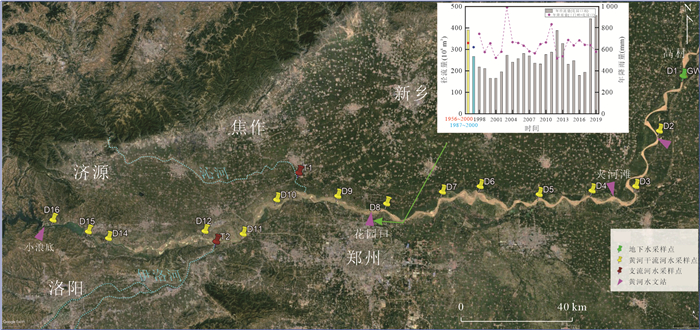
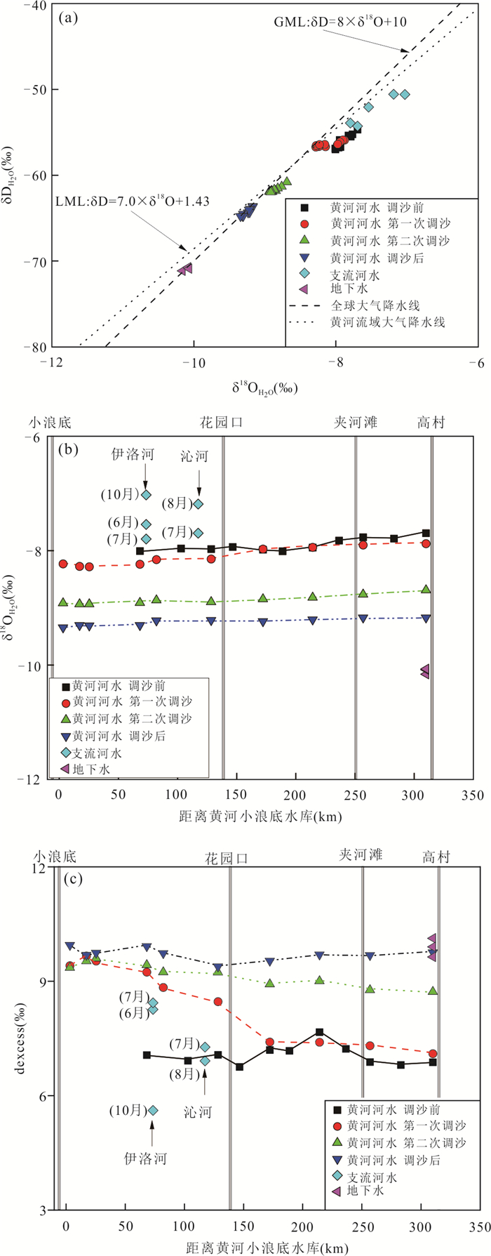
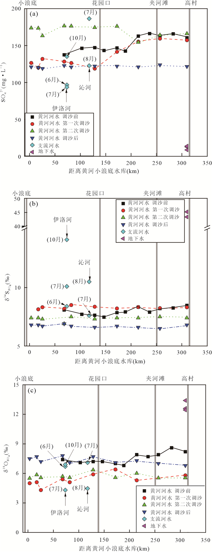
Weathering-derived sulfate (SO42-) from the Continent could be transported to the Ocean by river systems, and sulfate flux coupled with sulfur and oxygen isotope compositions (δ34SSO4 and δ18OSO4) were vital to the global sulfur cycling and sulfate isotope compositions in ocean. SO42- contents together with δ34SSO4and δ18OSO4 values were not only controlled by SO42- sources, but affected by sulfate bacterial reduction (SBR) in internal riversystem, however, these effects were still unclear, and particularly the influences from dam and water-sediment regulation scheme (WSRS) on sulfur cycling in watershed were still unknown. The Xiaolangdi Reservoir in the Yellow River was selected to solve this problem, and hydrochemical compositions, water isotope compositions (δDH2O and δ18OH2O), and δ34SSO4and δ18OSO4 were determined to constrain the effects of WSRS on riverine sulfate flux and isotope compositions by comparing the SO42- contents and isotope compositions before and after the WSRS. The results indicated that (1) WSRS occurred in July 2018, sediment discharge in August was due to sediment scoured by precipitation in midstream of Yellow River. The discharged river water during these two sediment removal had average δ18OH2O values of -8.1‰ and -8.9‰, and average SO42- concentrations of 1.43 mmol/L and 1.77 mmol/L, and average δ34SSO4 values of 8.3‰ and 7.4‰, and average δ18OSO4 values of 5.4‰ and 5.7‰, respectively. (2) The dischared river water before the WSRS (June) had positive average 18OH2O value of -7.0‰, moderate average SO42- concentration of 1.59 mmol/L, positive average δ34SSO4 and δ18OSO4values of 8.0‰ and 7.5‰, resepectively. The dischared river water after the WSRS (October) had negative average δ18OH2O value of -9.2‰, low average SO42- concentration of 1.26 mmol/L, negative average δ34SSO4 value of 6.7‰ and positive average δ18OSO4value of 7.3‰, respectively. (3) The WSRS in July resulted in the exposure of sediment, and the organic sulfur and sulfide from SBR had been reoxidized to sulfate, during which water oxygen was incorporated into fresh sulfate with low oxygen isotope composition, but there was small varitaion of δ34SSO4 and δ18OSO4values in downstream river water. (4) The SO42- flux was about 0.061 Tmol/a in 2018, and the proporation of SO42- flux during WSRS was about 14.8%. The flow-weighted average δ34SSO4 and δ18OSO4values of SO42- into the Ocean were 7.6‰ and 6.8‰, respectively. The conclusion is that the WSRS had altered the water-sediment environment in the Yellow River, and corresponding organic and sulfide were released into the air and reoxidized, which changed the sulfate flux and sulfur and oxygen isotope compostion to the Ocean.
Weathering-derived sulfate (SO42-) from the Continent could be transported to the Ocean by river systems, and sulfate flux coupled with sulfur and oxygen isotope compositions (δ34SSO4 and δ18OSO4) were vital to the global sulfur cycling and sulfate isotope compositions in ocean. SO42- contents together with δ34SSO4and δ18OSO4 values were not only controlled by SO42- sources, but affected by sulfate bacterial reduction (SBR) in internal riversystem, however, these effects were still unclear, and particularly the influences from dam and water-sediment regulation scheme (WSRS) on sulfur cycling in watershed were still unknown. The Xiaolangdi Reservoir in the Yellow River was selected to solve this problem, and hydrochemical compositions, water isotope compositions (δDH2O and δ18OH2O), and δ34SSO4and δ18OSO4 were determined to constrain the effects of WSRS on riverine sulfate flux and isotope compositions by comparing the SO42- contents and isotope compositions before and after the WSRS. The results indicated that (1) WSRS occurred in July 2018, sediment discharge in August was due to sediment scoured by precipitation in midstream of Yellow River. The discharged river water during these two sediment removal had average δ18OH2O values of -8.1‰ and -8.9‰, and average SO42- concentrations of 1.43 mmol/L and 1.77 mmol/L, and average δ34SSO4 values of 8.3‰ and 7.4‰, and average δ18OSO4 values of 5.4‰ and 5.7‰, respectively. (2) The dischared river water before the WSRS (June) had positive average 18OH2O value of -7.0‰, moderate average SO42- concentration of 1.59 mmol/L, positive average δ34SSO4 and δ18OSO4values of 8.0‰ and 7.5‰, resepectively. The dischared river water after the WSRS (October) had negative average δ18OH2O value of -9.2‰, low average SO42- concentration of 1.26 mmol/L, negative average δ34SSO4 value of 6.7‰ and positive average δ18OSO4value of 7.3‰, respectively. (3) The WSRS in July resulted in the exposure of sediment, and the organic sulfur and sulfide from SBR had been reoxidized to sulfate, during which water oxygen was incorporated into fresh sulfate with low oxygen isotope composition, but there was small varitaion of δ34SSO4 and δ18OSO4values in downstream river water. (4) The SO42- flux was about 0.061 Tmol/a in 2018, and the proporation of SO42- flux during WSRS was about 14.8%. The flow-weighted average δ34SSO4 and δ18OSO4values of SO42- into the Ocean were 7.6‰ and 6.8‰, respectively. The conclusion is that the WSRS had altered the water-sediment environment in the Yellow River, and corresponding organic and sulfide were released into the air and reoxidized, which changed the sulfate flux and sulfur and oxygen isotope compostion to the Ocean.


2022, 47(2): 607-621.
doi: 10.3799/dqkx.2021.115
Abstract:
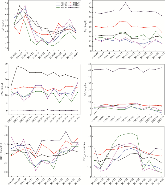
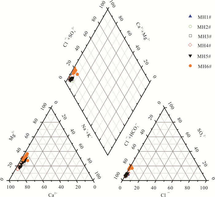
In order to reveal the source of SO42-and NO3-in the cave water and their influence on the hydrogeochemical process, a complete hydrological year monitoring was carried out at six monitor points in Mahuang Cave from August 2018 to July 2019. The results showed as follows: (1)The cave waters hydrochemical types are HCO3-Ca·Mg and HCO3·SO4-Ca·Mg; (2)SO42- and NO3- are mainly derived by agricultural activities, atmospheric deposition and gypsum dissolution, and their sources are different at different drip points. NO3- in the Mahuang cave is mainly caused by agricultural activities and atmospheric N deposition, while SO42- is supplemented by agricultural activities and gypsum dissolution; The SO42- and NO3- both participate in the karstification and accelerate the dissolution of bedrock; (3)Based on the estimation of hydrochemistry method and stable isotope technique, the contribution of DIC of SO42- and NO3-cave water ranges from 0.05 to 0.61. The release of DIC also changes the ion concentration in the water, causing disturbance to karstification and presenting a general pattern of Dry season > Rainy season and dripwaters > fissure water. Similarly, due to the complexity and unknowability of karst area, the combination and comparison of various methods should be paid attention to in the systematic study of karst area, so as to improve the accuracy and credibility of the study.
In order to reveal the source of SO42-and NO3-in the cave water and their influence on the hydrogeochemical process, a complete hydrological year monitoring was carried out at six monitor points in Mahuang Cave from August 2018 to July 2019. The results showed as follows: (1)The cave waters hydrochemical types are HCO3-Ca·Mg and HCO3·SO4-Ca·Mg; (2)SO42- and NO3- are mainly derived by agricultural activities, atmospheric deposition and gypsum dissolution, and their sources are different at different drip points. NO3- in the Mahuang cave is mainly caused by agricultural activities and atmospheric N deposition, while SO42- is supplemented by agricultural activities and gypsum dissolution; The SO42- and NO3- both participate in the karstification and accelerate the dissolution of bedrock; (3)Based on the estimation of hydrochemistry method and stable isotope technique, the contribution of DIC of SO42- and NO3-cave water ranges from 0.05 to 0.61. The release of DIC also changes the ion concentration in the water, causing disturbance to karstification and presenting a general pattern of Dry season > Rainy season and dripwaters > fissure water. Similarly, due to the complexity and unknowability of karst area, the combination and comparison of various methods should be paid attention to in the systematic study of karst area, so as to improve the accuracy and credibility of the study.


2022, 47(2): 622-632.
doi: 10.3799/dqkx.2021.105
Abstract:
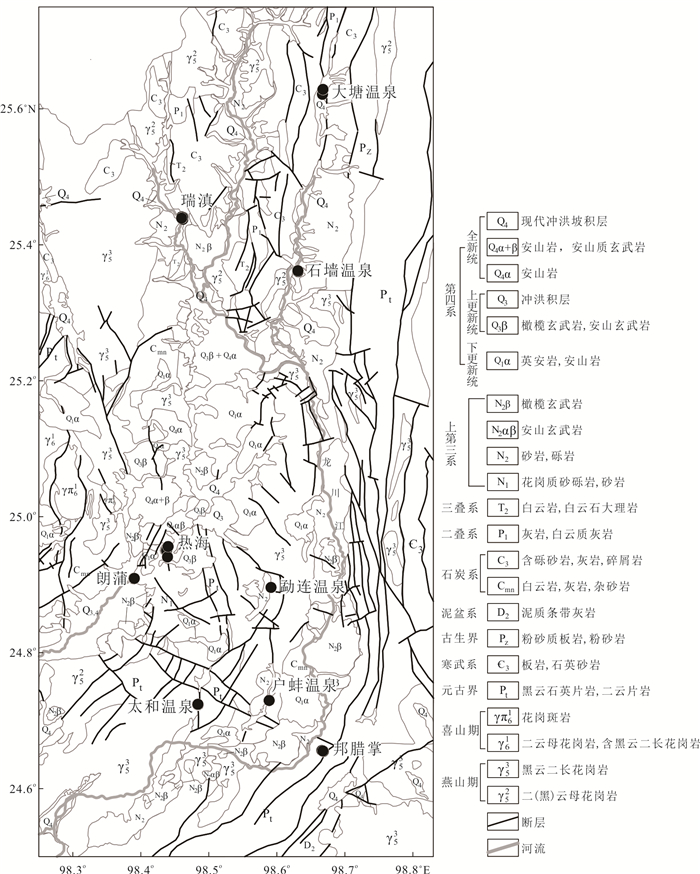
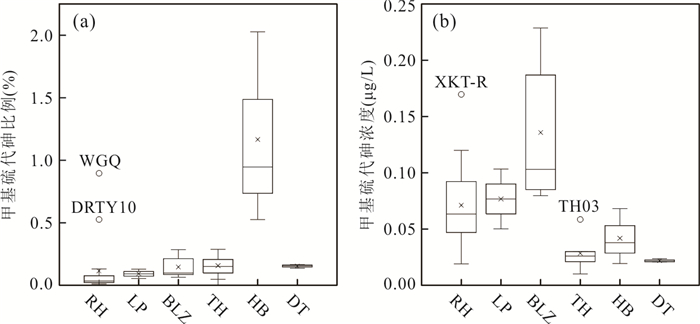
In order to study the speciation of arsenic (As) in hot springs and their distribution and transformation patterns, IC-ICP-MS quantification and hydrogeochemical analyses were conducted for various arsenic species in Tengchong hot springs in Yunnan Province. In 91 hot spring samples, 11 As species were detected, which include arsenate, arsenite, inorganic thioarsenates, methylated oxyarsenates and methylated thioarsenates. Arsenate and arsenite were predominate species followed by inorganic thioarsenates, unlike inorganic species, methylated As occurred as minor species in Tengchong hot springs. The content of thioarsenates and their degree of thiolation are positively correlated with S/As molar ratios. The lack of methylated oxyarsenates was probably the reason for low methylated thioarsenate levels, besides, the S/As molar ratio, total As, temperature, pH, Eh and TDS can also affect the formation and transformation of methylated thioarsenates. Methylated thioarsenates may undergo a series of transformations and interfacial reactions on the surface drainage of hot springs such as de-thiolation, de-methylation and then adsorption by sediments. Other As species can be converted to methylated thioarsenate in downstream areas with relatively low temperatures, low flow rates and significant microbial activity. The thiolated and methylated species of As are widely distributed in hot springs, and the highly toxic methylated thioarsenates have high mobility and are likely to reappear in hot spring drainage environment, which should attract the attention of relevant studies.
In order to study the speciation of arsenic (As) in hot springs and their distribution and transformation patterns, IC-ICP-MS quantification and hydrogeochemical analyses were conducted for various arsenic species in Tengchong hot springs in Yunnan Province. In 91 hot spring samples, 11 As species were detected, which include arsenate, arsenite, inorganic thioarsenates, methylated oxyarsenates and methylated thioarsenates. Arsenate and arsenite were predominate species followed by inorganic thioarsenates, unlike inorganic species, methylated As occurred as minor species in Tengchong hot springs. The content of thioarsenates and their degree of thiolation are positively correlated with S/As molar ratios. The lack of methylated oxyarsenates was probably the reason for low methylated thioarsenate levels, besides, the S/As molar ratio, total As, temperature, pH, Eh and TDS can also affect the formation and transformation of methylated thioarsenates. Methylated thioarsenates may undergo a series of transformations and interfacial reactions on the surface drainage of hot springs such as de-thiolation, de-methylation and then adsorption by sediments. Other As species can be converted to methylated thioarsenate in downstream areas with relatively low temperatures, low flow rates and significant microbial activity. The thiolated and methylated species of As are widely distributed in hot springs, and the highly toxic methylated thioarsenates have high mobility and are likely to reappear in hot spring drainage environment, which should attract the attention of relevant studies.


2022, 47(2): 633-641.
doi: 10.3799/dqkx.2021.102
Abstract:
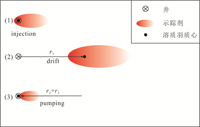
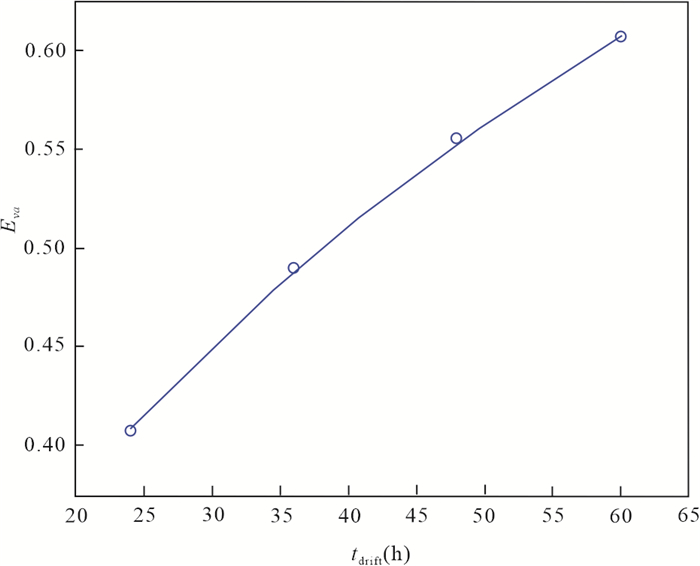
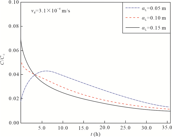
For the purpose of analyzingthe influencingmechanism of groundwater flow velocity in the injection phase (GFVIP) and dispersivity on calculation of groundwater velocity, this study employed GMS (Groundwater Modeling System)to develop numerical models of single-well push-pull (SWPP) test, and the numerical results are compared with theapproximately analytical ones of Leap and Kaplan (1988)to uncover the effects of GFVIP and dispersivity on the calculation accuracy of the analytical model. The results indicate that a larger groundwater velocity or a longer drift time results in a larger misestimation of groundwater velocity bythe model of Leap and Kaplan (1988); GFVIP has little impact on the migration distance of solute plumecentroid, thus the impact of GFIP on the approximately analytical model can be neglected. Additionally, a greater dispersivity results in a more significant calculation error by the model of Leap and Kaplan (1988). Overall, the GFVIP has limited influence on the calculation results by the approximately analytical modelof Leap and Kaplan (1988), while dispersivity has remarkable influence on the estimation accuracy.
For the purpose of analyzingthe influencingmechanism of groundwater flow velocity in the injection phase (GFVIP) and dispersivity on calculation of groundwater velocity, this study employed GMS (Groundwater Modeling System)to develop numerical models of single-well push-pull (SWPP) test, and the numerical results are compared with theapproximately analytical ones of Leap and Kaplan (1988)to uncover the effects of GFVIP and dispersivity on the calculation accuracy of the analytical model. The results indicate that a larger groundwater velocity or a longer drift time results in a larger misestimation of groundwater velocity bythe model of Leap and Kaplan (1988); GFVIP has little impact on the migration distance of solute plumecentroid, thus the impact of GFIP on the approximately analytical model can be neglected. Additionally, a greater dispersivity results in a more significant calculation error by the model of Leap and Kaplan (1988). Overall, the GFVIP has limited influence on the calculation results by the approximately analytical modelof Leap and Kaplan (1988), while dispersivity has remarkable influence on the estimation accuracy.


2022, 47(2): 642-651.
doi: 10.3799/dqkx.2021.034
Abstract:
How to scientifically evaluate the groundwater runoff modulus under field conditions has important application value to meet the needs of engineering hydrogeology. In this paper, the study of groundwater runoff modulus under site conditions in the Parlung Zangbo watershed is carried out by establishing a linear regression model combined with technical means such as field survey, remote sensing interpretation and meteorological and hydrological observations. The results show that the study area has a typical seasonal snowmelt law. The snow accumulate in winter melt into runoff in summer, which serves as an additional source of groundwater recharge. After removing the influence of snowmelt runoff on the runoff modulus, the groundwater runoff modulus of magmatic aquifer, metamorphic aquifer, clastic aquifer and carbonate-clastic aquifer in the study area are respectively between 1.081-2.792 L/s·km2, 1.833-3.225 L/s·km2, 1.128-2.889 L/s·km2, 3.455-3.879 L/s·km2. The estimation results show that the groundwater runoff estimation model established in this paper can be used as a new method for estimating groundwater runoff modulus in southeastern Tibet and similar conditions, providing important hydrogeological parameter support for large-scale infrastructure projects in this area included the cascade development of the lower reaches of the Yarlung Zangbo River.
How to scientifically evaluate the groundwater runoff modulus under field conditions has important application value to meet the needs of engineering hydrogeology. In this paper, the study of groundwater runoff modulus under site conditions in the Parlung Zangbo watershed is carried out by establishing a linear regression model combined with technical means such as field survey, remote sensing interpretation and meteorological and hydrological observations. The results show that the study area has a typical seasonal snowmelt law. The snow accumulate in winter melt into runoff in summer, which serves as an additional source of groundwater recharge. After removing the influence of snowmelt runoff on the runoff modulus, the groundwater runoff modulus of magmatic aquifer, metamorphic aquifer, clastic aquifer and carbonate-clastic aquifer in the study area are respectively between 1.081-2.792 L/s·km2, 1.833-3.225 L/s·km2, 1.128-2.889 L/s·km2, 3.455-3.879 L/s·km2. The estimation results show that the groundwater runoff estimation model established in this paper can be used as a new method for estimating groundwater runoff modulus in southeastern Tibet and similar conditions, providing important hydrogeological parameter support for large-scale infrastructure projects in this area included the cascade development of the lower reaches of the Yarlung Zangbo River.


2022, 47(2): 652-661.
doi: 10.3799/dqkx.2021.095
Abstract:
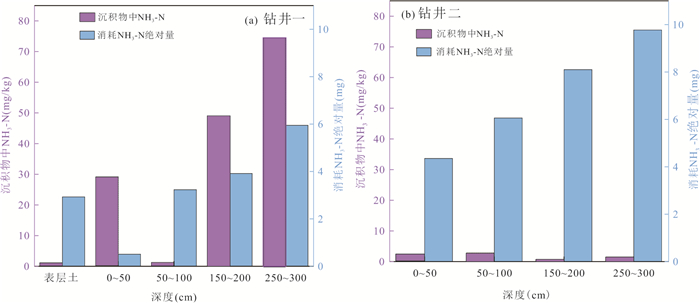
At present, the research on the nitrification kinetics and the degradation of organic pollutants by co-metabolism are mostly based on the pure culture system of microorganisms in laboratory, and few are derived from environmental samples in the field. The study took the sediments of No.1 Pond of Yanjia Lake as the research object. Through field drilling and sampling, different points are selected for nitrification experiments with adding ammonium. The results showed that the nitrification obvious occurred in the topsoil and the sediments at the depth of 50-100 cm of well 1. At the same time, the content of hexachlorobenzene in the organic pollutants decreased the most, by 36.6% and 49.4% respectively. It can be considered to screen nitrification and hexachlorobenzene co-metabolism microorganisms from these two sediments. No obvious nitrification process was detected in the sediments at the depth of 250-300 cm of well 1 and 150-200 cm of well 2, but there were processes such as ammonium adsorption and being used as nitrogen source to decrease ammonium concentration. The contents of r-HCH, heptachlor-epoxide and endrin Ketone at the depth of 250-300 cm of well 1 decreased by 48.8%, 90.2% and 63.3%, respectively, and those at the depth of 150-200 cm of well 2 decreased by 55.8%, 87.4% and 32.1%, respectively. It shows that adding ammonium to these sediments can promote the degradation of organic pollutants.
At present, the research on the nitrification kinetics and the degradation of organic pollutants by co-metabolism are mostly based on the pure culture system of microorganisms in laboratory, and few are derived from environmental samples in the field. The study took the sediments of No.1 Pond of Yanjia Lake as the research object. Through field drilling and sampling, different points are selected for nitrification experiments with adding ammonium. The results showed that the nitrification obvious occurred in the topsoil and the sediments at the depth of 50-100 cm of well 1. At the same time, the content of hexachlorobenzene in the organic pollutants decreased the most, by 36.6% and 49.4% respectively. It can be considered to screen nitrification and hexachlorobenzene co-metabolism microorganisms from these two sediments. No obvious nitrification process was detected in the sediments at the depth of 250-300 cm of well 1 and 150-200 cm of well 2, but there were processes such as ammonium adsorption and being used as nitrogen source to decrease ammonium concentration. The contents of r-HCH, heptachlor-epoxide and endrin Ketone at the depth of 250-300 cm of well 1 decreased by 48.8%, 90.2% and 63.3%, respectively, and those at the depth of 150-200 cm of well 2 decreased by 55.8%, 87.4% and 32.1%, respectively. It shows that adding ammonium to these sediments can promote the degradation of organic pollutants.


2022, 47(2): 662-673.
doi: 10.3799/dqkx.2021.031
Abstract:
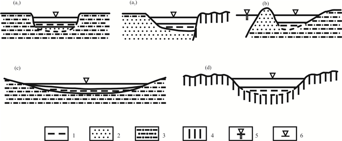
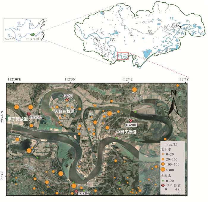
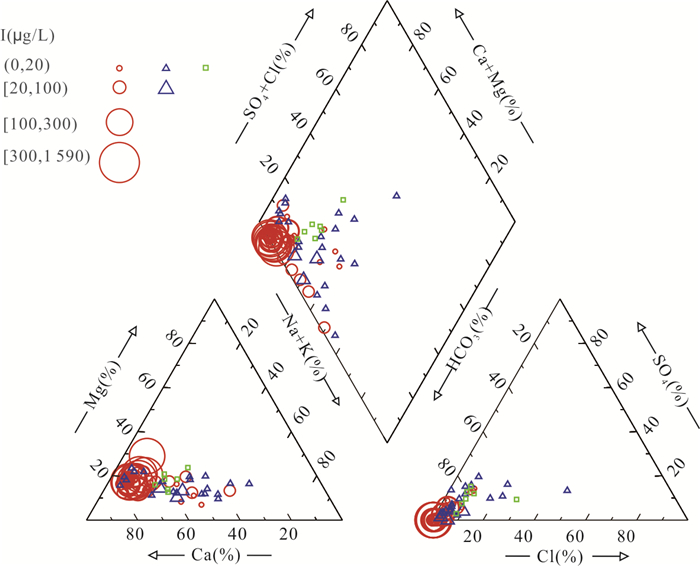
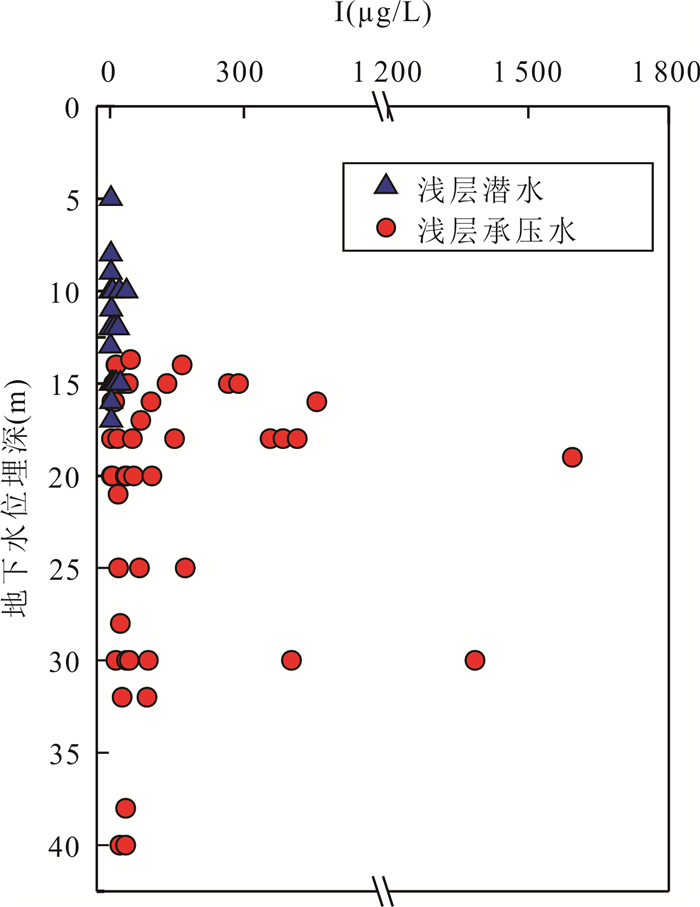
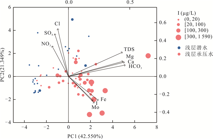
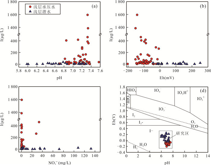
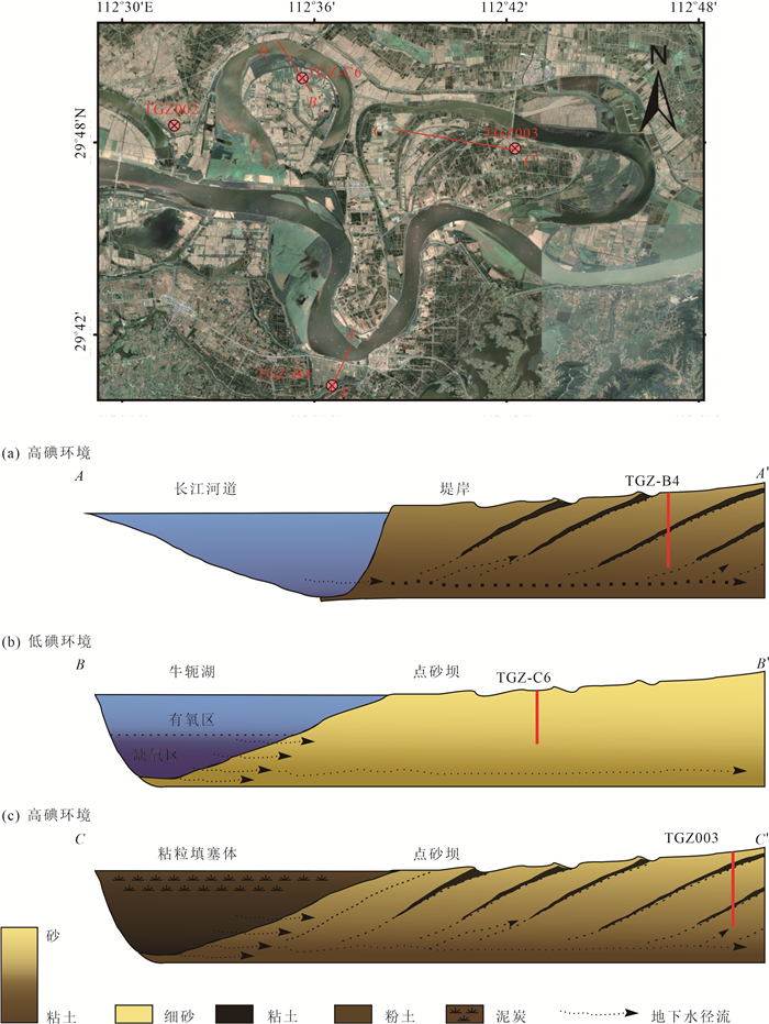
High iodine groundwater (iodine concentration greater than 100 μg/L) is widely distributed in coastal areas and arid inland basins in China, threatening the drinking water safety of nearly ten million people, but the understanding of the distribution andformationof iodine in groundwater in humid areas is still very weak. In this study, 75 shallow groundwater samples and 7 surface water samples were collected fromoxbowsof the middle reach of the Yangtze River for hydrogeochemical analysis, the spatial distribution characteristics of iodine in groundwater were identified, the water environmental factors and hydrogeochemical process of iodine enrichment were identified by principal component analysis, and the control effect of sedimentary environment evolution on iodine enrichment was discussed through the lithological analysis of four boreholes at different locations. The concentration of iodine in groundwater ranged from 0.78 μg/L to 1 590 μg/L, and 25% of the samples exceed the determination value of water iodine content in water source areas with high iodine content in China (100 μg/L). The high iodine groundwater mainly occurs in the shallow confined aquifer, distributed in the concave bank of the Yangtze River and the clayfilled oxbow lake. The strong reducing environment rich in organic matter buried under the deposition in oxbows of the middle reach of Yangtze River is conducive to the release of iodine from the sediments to groundwater. Microbially degradation of organic matter and reductive dissolution of iron hydroxide in aquifer sediments are the main hydrogeochemical processes controlling the formation of high iodine groundwater in the study area. The low-permeability clay packing in the later period of the oxbow lake and the thick clay layer deposited on the concave bank of the river meander created a closed and stagnant groundwater environment for iodine enrichment.
High iodine groundwater (iodine concentration greater than 100 μg/L) is widely distributed in coastal areas and arid inland basins in China, threatening the drinking water safety of nearly ten million people, but the understanding of the distribution andformationof iodine in groundwater in humid areas is still very weak. In this study, 75 shallow groundwater samples and 7 surface water samples were collected fromoxbowsof the middle reach of the Yangtze River for hydrogeochemical analysis, the spatial distribution characteristics of iodine in groundwater were identified, the water environmental factors and hydrogeochemical process of iodine enrichment were identified by principal component analysis, and the control effect of sedimentary environment evolution on iodine enrichment was discussed through the lithological analysis of four boreholes at different locations. The concentration of iodine in groundwater ranged from 0.78 μg/L to 1 590 μg/L, and 25% of the samples exceed the determination value of water iodine content in water source areas with high iodine content in China (100 μg/L). The high iodine groundwater mainly occurs in the shallow confined aquifer, distributed in the concave bank of the Yangtze River and the clayfilled oxbow lake. The strong reducing environment rich in organic matter buried under the deposition in oxbows of the middle reach of Yangtze River is conducive to the release of iodine from the sediments to groundwater. Microbially degradation of organic matter and reductive dissolution of iron hydroxide in aquifer sediments are the main hydrogeochemical processes controlling the formation of high iodine groundwater in the study area. The low-permeability clay packing in the later period of the oxbow lake and the thick clay layer deposited on the concave bank of the river meander created a closed and stagnant groundwater environment for iodine enrichment.


2022, 47(2): 674-688.
doi: 10.3799/dqkx.2021.027
Abstract:
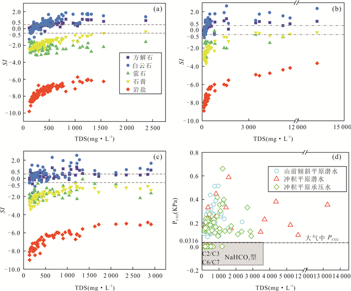
The middle of the northern piedmont of Tianshan Mountain has complicated geological structure and developed faults. It is of great significance to ascertain the formation mechanism of soda water (NaHCO3 type) for understanding the relationship between groundwater hydrogeochemical process and geological conditions in the middle of the northern piedmont of Tianshan Mountain. Based on 209 groups of groundwater samples in the middle plain of the northern piedmont of Tianshan Mountain, Xinjiang, combined with geological conditions, semi-variation model, multiple linear regression of absolute principal component score model (PCA/APCS-MLR) were used to identify the spatial distribution characteristics of hydrochemical types in unconfined water and confined water, source contribution of groundwater chemical components, and the hydrogeochemical process of soda water formation and the controlling factors of geological conditions. The results showed that Na2SO4, NaHCO3 and Na2SO4 are the main types of unconfined groundwater in piedmont inclined plain, unconfined groundwater and confined groundwater in alluvial plain, respectively, the soda water in piedmont clinoplainun confined water, alluvial plain unconfined water and confined water accounted for 7.18%, 14.83% and 6.22% of the total water samples respectively. The spatial autocorrelation of Na+, HCO3- and TDS is strong in confined groundwater, but weak in unconfined groundwater, when TDS is less than 1 000 mg/L, NaHCO3 type water will be formed. The contribution rates of dissolution-enrichment factor (F1), external input factor (F2), native geological factor (F3) and geological environment factor (F4) to groundwater chemical components were 29.44%, 15.99%, 7.70% and 6.71% respectively. The formation process of soda water is not only controlled by various hydrogeochemical processes such as mineral dissolution, cation exchange, mixing and desulphidation, but also affected by geological conditions such as geological environment, geological structure, hydrogeological conditions.
The middle of the northern piedmont of Tianshan Mountain has complicated geological structure and developed faults. It is of great significance to ascertain the formation mechanism of soda water (NaHCO3 type) for understanding the relationship between groundwater hydrogeochemical process and geological conditions in the middle of the northern piedmont of Tianshan Mountain. Based on 209 groups of groundwater samples in the middle plain of the northern piedmont of Tianshan Mountain, Xinjiang, combined with geological conditions, semi-variation model, multiple linear regression of absolute principal component score model (PCA/APCS-MLR) were used to identify the spatial distribution characteristics of hydrochemical types in unconfined water and confined water, source contribution of groundwater chemical components, and the hydrogeochemical process of soda water formation and the controlling factors of geological conditions. The results showed that Na2SO4, NaHCO3 and Na2SO4 are the main types of unconfined groundwater in piedmont inclined plain, unconfined groundwater and confined groundwater in alluvial plain, respectively, the soda water in piedmont clinoplainun confined water, alluvial plain unconfined water and confined water accounted for 7.18%, 14.83% and 6.22% of the total water samples respectively. The spatial autocorrelation of Na+, HCO3- and TDS is strong in confined groundwater, but weak in unconfined groundwater, when TDS is less than 1 000 mg/L, NaHCO3 type water will be formed. The contribution rates of dissolution-enrichment factor (F1), external input factor (F2), native geological factor (F3) and geological environment factor (F4) to groundwater chemical components were 29.44%, 15.99%, 7.70% and 6.71% respectively. The formation process of soda water is not only controlled by various hydrogeochemical processes such as mineral dissolution, cation exchange, mixing and desulphidation, but also affected by geological conditions such as geological environment, geological structure, hydrogeological conditions.


2022, 47(2): 689-699.
doi: 10.3799/dqkx.2021.013
Abstract:
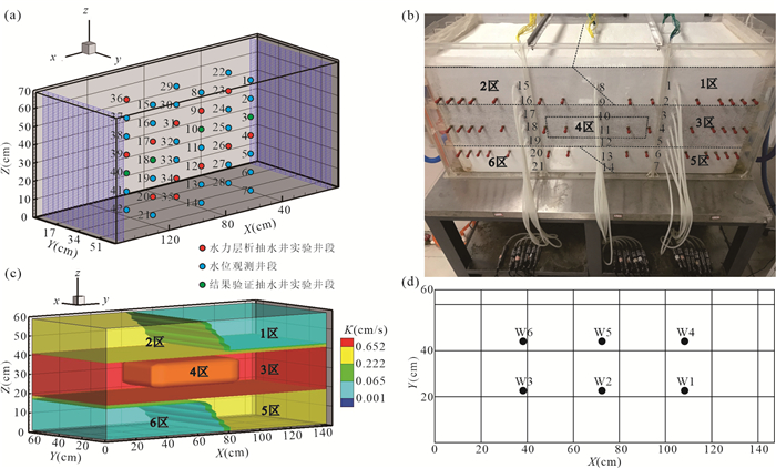
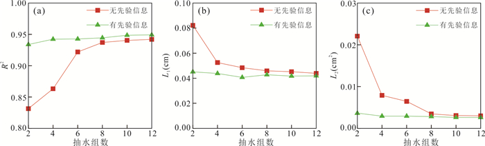
Hydraulic tomography (HT) can accurately characterize the hydraulic conductivity (K) of field heterogeneous aquifer, but the field test cost is relatively high and pumping test need to be optimized. In order to explore the effect of number of pumping tests and prior information on the K estimates, we constructed a laboratory three-dimensional sandbox with heterogeneous aquifer, and then carried out pumping tests in HT survey. The K fields are respectively estimated using HT with and without 42 K values of core samples as prior information. The estimated K fields from different cases are then used to predict non-dependent pumping tests and compare the accuracy of estimated K fields. With increasing number of pumping tests, the estimated K fields are gradually improved. When pumping tests increase to eight groups, the K estimates are not significantly improve with the increase of pumping tests. 42 K values of core samples as prior information can greatly improve the K estimates in HT survey. The K obtained from only two pumping tests with prior information has almost same accuracy as the K estimates from the case of eight pumping tests without prior information.
Hydraulic tomography (HT) can accurately characterize the hydraulic conductivity (K) of field heterogeneous aquifer, but the field test cost is relatively high and pumping test need to be optimized. In order to explore the effect of number of pumping tests and prior information on the K estimates, we constructed a laboratory three-dimensional sandbox with heterogeneous aquifer, and then carried out pumping tests in HT survey. The K fields are respectively estimated using HT with and without 42 K values of core samples as prior information. The estimated K fields from different cases are then used to predict non-dependent pumping tests and compare the accuracy of estimated K fields. With increasing number of pumping tests, the estimated K fields are gradually improved. When pumping tests increase to eight groups, the K estimates are not significantly improve with the increase of pumping tests. 42 K values of core samples as prior information can greatly improve the K estimates in HT survey. The K obtained from only two pumping tests with prior information has almost same accuracy as the K estimates from the case of eight pumping tests without prior information.


2022, 47(2): 700-716.
doi: 10.3799/dqkx.2021.043
Abstract:
Deep groundwater sulfate in the piedmont alluvial plain in Jiaozuo had been increasing, however, the mechanism is still unclear. To illustrate the pollution mechanism of deep groundwater, deep groundwater in different hosting conditions was sampled to compare, and hydro-chemical compositions, hydrogen and oxygen isotopes (δDH2O and δ18OH2O), sulfate sulfur and oxygen isotopes (δ34SSO4 and δ18OSO4) were determined to constrain the sulfate sources, pollution pathways and sulfate bacterial reduction processes with the presence of anthropogenic activities. The results indicated that there were small variations of monthly hydro-chemical and isotope compositions in respective deep groundwaters, but large spatial differences were found in the hydro-chemical compositions of these deep groundwater. Sulfate in the undisturbed deep groundwater was mainly derived from atmospheric deposition, pyrite oxidation and gypsum dissolution, and the bacterial sulfate reduction obviously occurred; There were two kinds of pollution pathways and processes in the polluted deep groundwater. First was that in the piedmont where deep groundwater was recharged, due to no obvious aquifuge between them, the precipitation and river water containing industrial wastes could easily infiltrate into deep groundwater with the result of increasing sulfate concentrations. Second was that in the discharge zone, increased deep groundwater sulfate was related with leapfrog recharge from the above aquifer where sulfate was rich, and the leapfrog recharge was due to overwhelming deep groundwater pumping. Our results well illustrated the sulfate pollution mechanism in deep groundwater underneath the piedmont alluvial plain in Jiaozuo, and provided vitally scientific evidences on effective management and protection of deep groundwater source.
Deep groundwater sulfate in the piedmont alluvial plain in Jiaozuo had been increasing, however, the mechanism is still unclear. To illustrate the pollution mechanism of deep groundwater, deep groundwater in different hosting conditions was sampled to compare, and hydro-chemical compositions, hydrogen and oxygen isotopes (δDH2O and δ18OH2O), sulfate sulfur and oxygen isotopes (δ34SSO4 and δ18OSO4) were determined to constrain the sulfate sources, pollution pathways and sulfate bacterial reduction processes with the presence of anthropogenic activities. The results indicated that there were small variations of monthly hydro-chemical and isotope compositions in respective deep groundwaters, but large spatial differences were found in the hydro-chemical compositions of these deep groundwater. Sulfate in the undisturbed deep groundwater was mainly derived from atmospheric deposition, pyrite oxidation and gypsum dissolution, and the bacterial sulfate reduction obviously occurred; There were two kinds of pollution pathways and processes in the polluted deep groundwater. First was that in the piedmont where deep groundwater was recharged, due to no obvious aquifuge between them, the precipitation and river water containing industrial wastes could easily infiltrate into deep groundwater with the result of increasing sulfate concentrations. Second was that in the discharge zone, increased deep groundwater sulfate was related with leapfrog recharge from the above aquifer where sulfate was rich, and the leapfrog recharge was due to overwhelming deep groundwater pumping. Our results well illustrated the sulfate pollution mechanism in deep groundwater underneath the piedmont alluvial plain in Jiaozuo, and provided vitally scientific evidences on effective management and protection of deep groundwater source.
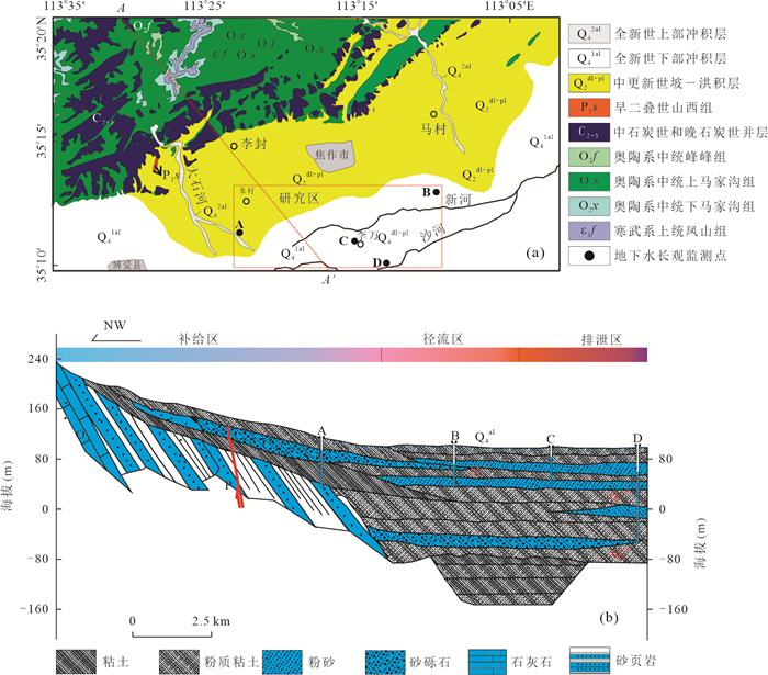


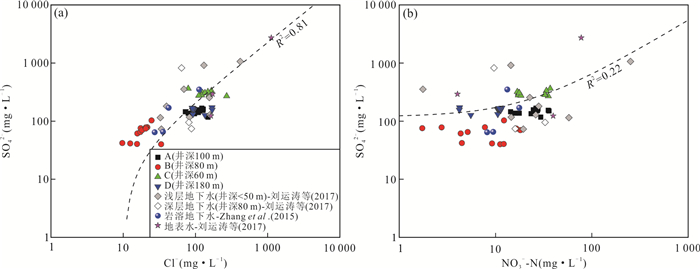
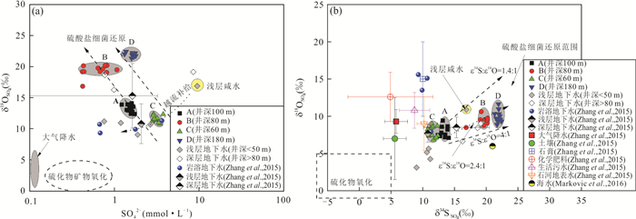
2022, 47(2): 717-728.
doi: 10.3799/dqkx.2021.008
Abstract:
The construction of the tunnel caused changes in the groundwater flow field, which seriously affected the process of regional water migration. Taking the karst trough of Zhongliang Mountain in Chongqing as an example, we collected precipitation, soil water, groundwater and tunnel drainage from April 2017 to April 2019. This study used stable hydrogen and oxygen isotopes to analyze the soil water and groundwater migration processes in the tunnel-affected zone and non-tunnel-affected zone, and explored the impact of tunnel construction on it.The results showed that the change of δ2H and δ18O of soil water in the tunnel-affected area was greater than that of the tunnel-affected area, and the change of groundwater δ2H and δ18O was more stable than that of the non-tunnel-affected area.Compared with the soil water and groundwater in the non-tunnel-affected area, the δ2H and δ18O of the shallow soil water in the tunnel-affected area were heavier in summer, the δ2H and δ18O of deep soil were heavier in autumn, the δ2H and δ18O of shallow karst spring water were basically heavier in all seasons, and the underground river water was δ2H and δ18O tends to be heavier in winter, and the δ2H and δ18O of water bodies in other seasons were basically lighter. The difference of meantransit time and young water fraction between the tunnel-affected zone and the non-tunnel-affected zone gradually decreased from soil water to groundwater.The meantransit time of soil water in the tunnel-affected area was 25.4 days shorter than that in the non-tunnel-affected area, the young water fraction was 13.5% higher, the meantransit time of groundwater was 16.1 days less, and the young water fraction was 3.4% higher.To sum up, the tunnel construction accelerated the water movement speed in the tunnel-affected zone to a certain extent, resulting in the reduction of retained water in the soil layer and the weakening of water mixing.
The construction of the tunnel caused changes in the groundwater flow field, which seriously affected the process of regional water migration. Taking the karst trough of Zhongliang Mountain in Chongqing as an example, we collected precipitation, soil water, groundwater and tunnel drainage from April 2017 to April 2019. This study used stable hydrogen and oxygen isotopes to analyze the soil water and groundwater migration processes in the tunnel-affected zone and non-tunnel-affected zone, and explored the impact of tunnel construction on it.The results showed that the change of δ2H and δ18O of soil water in the tunnel-affected area was greater than that of the tunnel-affected area, and the change of groundwater δ2H and δ18O was more stable than that of the non-tunnel-affected area.Compared with the soil water and groundwater in the non-tunnel-affected area, the δ2H and δ18O of the shallow soil water in the tunnel-affected area were heavier in summer, the δ2H and δ18O of deep soil were heavier in autumn, the δ2H and δ18O of shallow karst spring water were basically heavier in all seasons, and the underground river water was δ2H and δ18O tends to be heavier in winter, and the δ2H and δ18O of water bodies in other seasons were basically lighter. The difference of meantransit time and young water fraction between the tunnel-affected zone and the non-tunnel-affected zone gradually decreased from soil water to groundwater.The meantransit time of soil water in the tunnel-affected area was 25.4 days shorter than that in the non-tunnel-affected area, the young water fraction was 13.5% higher, the meantransit time of groundwater was 16.1 days less, and the young water fraction was 3.4% higher.To sum up, the tunnel construction accelerated the water movement speed in the tunnel-affected zone to a certain extent, resulting in the reduction of retained water in the soil layer and the weakening of water mixing.

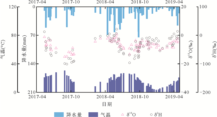

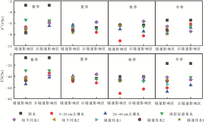
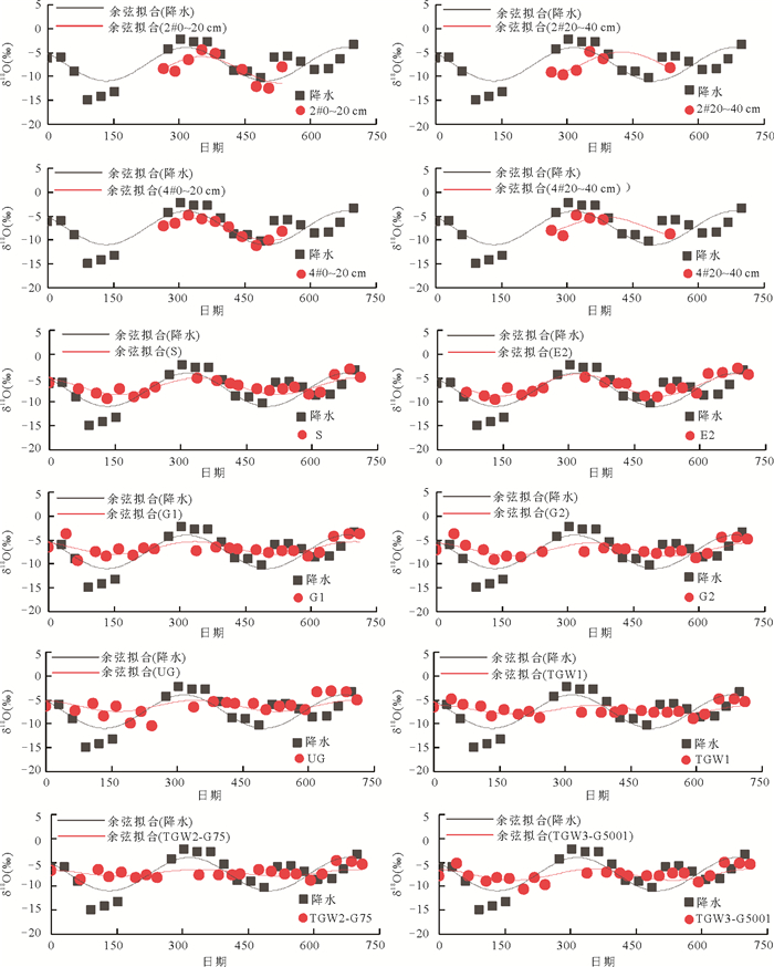
2022, 47(2): 729-741.
doi: 10.3799/dqkx.2021.038
Abstract:
The content of manganese in shallow groundwater in Jianghan Plain is generally high. Studying the distribution characteristics of manganese in the hyporheic zone helps to understand manganese's biogeochemical process in the hyporheic zone. It is of great significance for guiding the protection of river and groundwater quality. This study takes the lateral hyporheic zone in the Han River's lower reaches as the research object. The temporal and spatial distribution of dissolved manganese under different interaction directions between river and groundwater in the lateral hyporheic zone is studied and discussed by detecting manganese concentration and its related parameters in the river and groundwater. The results showed that the dissolved manganese is enriched in the river-groundwater lateral interaction zone near the riparian zone, and the manganese content is higher in the place where there is local reverse flow; The phenomenon of local enrichment is more obvious in the interactive zone where river water supplies groundwater. After flooding for 1-3 months, the enrichment area migrates with the direction of water flow; The dissolved manganese concentration in the groundwater of the study area has a very significant positive correlation with HCO3-, Mg2+, Ca2+, and has a remarkably substantial negative correlation with NO3-. It is also negatively correlated with Fe2+. However, it is not related to the Eh and pH of groundwater in the hyporheic zone.In a word, the spatial and temporal distribution of dissolved manganese in the hyporheic zone is influenced by topographic conditions, hydrodynamics and hydrochemistry.
The content of manganese in shallow groundwater in Jianghan Plain is generally high. Studying the distribution characteristics of manganese in the hyporheic zone helps to understand manganese's biogeochemical process in the hyporheic zone. It is of great significance for guiding the protection of river and groundwater quality. This study takes the lateral hyporheic zone in the Han River's lower reaches as the research object. The temporal and spatial distribution of dissolved manganese under different interaction directions between river and groundwater in the lateral hyporheic zone is studied and discussed by detecting manganese concentration and its related parameters in the river and groundwater. The results showed that the dissolved manganese is enriched in the river-groundwater lateral interaction zone near the riparian zone, and the manganese content is higher in the place where there is local reverse flow; The phenomenon of local enrichment is more obvious in the interactive zone where river water supplies groundwater. After flooding for 1-3 months, the enrichment area migrates with the direction of water flow; The dissolved manganese concentration in the groundwater of the study area has a very significant positive correlation with HCO3-, Mg2+, Ca2+, and has a remarkably substantial negative correlation with NO3-. It is also negatively correlated with Fe2+. However, it is not related to the Eh and pH of groundwater in the hyporheic zone.In a word, the spatial and temporal distribution of dissolved manganese in the hyporheic zone is influenced by topographic conditions, hydrodynamics and hydrochemistry.


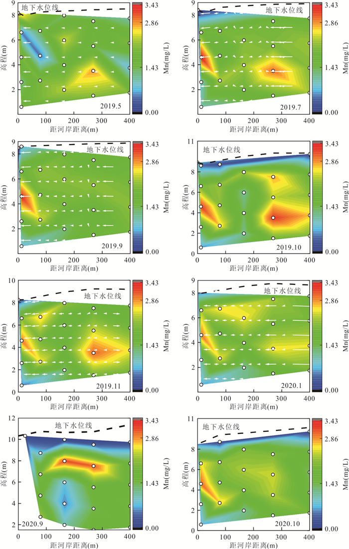

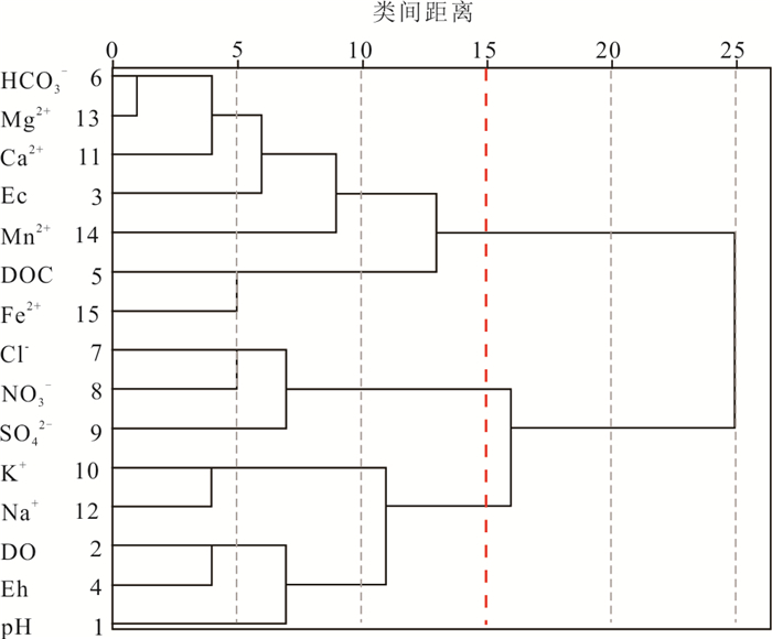
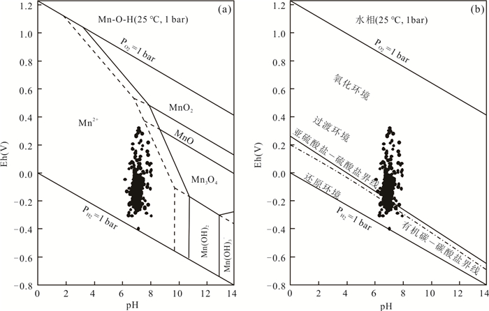

2022, 47(2): 742-756.
doi: 10.3799/dqkx.2021.063
Abstract:
In-situ microanalysis of polymetallic nodule can better reveal the occurrence and migration of elements in the growth process of polymetallic nodules than bulk nodule analysis, and provide new evidence for understanding the enrichment mechanism and genesis of polymetallic nodules. In this study, electron probe microanalysis (EPMA) and laser ablation inductively coupled plasma mass spectrometry (LA-ICP-MS) were used to analyze the polymetallic nodule collected from the Clarion-Clipperton Fault Zone (CCFZ) of the East Pacific Ocean. The results show that the main minerals of the nodule are vernadite, 10 Å manganite and FeOOH. From the inside to the outside, the ferromanganese nodule can be divided into four distinct layer groups: L1, L2, L3 and L4, the average contents of Mn and Fe are 32.2 and 13.3%, 39.1 and 5.2%, 37.0 and 3.4%, 33.1 and 7.8%, respectively. The Mn/Fe ratio increases as a whole, and corresponding to 2.8, 16.6, 19.7 and 10.6, respectively. The variation of Co+Ni+Cu content shows similar trend, with the average content of 1.9%, 3.3%, 3.8% and 3.0%, respectively.The relationship of element content shows that Co mainly occurs in hydrogeneticvernadite, Ni and Cu both occur in hydrogenetic and diagenetic Mn phase minerals, while the enrichment ability of diagenetic 10 Å manganite is stronger than hydrogeneticvernadite. Based on the element composition and microstructure, the layers can be divided into hydrogenetic layer, mixed layer, diagenetic layer and mixed layer, respectively, and the nodules experienced hydrogenetic growth and diagenetic growth successively.
In-situ microanalysis of polymetallic nodule can better reveal the occurrence and migration of elements in the growth process of polymetallic nodules than bulk nodule analysis, and provide new evidence for understanding the enrichment mechanism and genesis of polymetallic nodules. In this study, electron probe microanalysis (EPMA) and laser ablation inductively coupled plasma mass spectrometry (LA-ICP-MS) were used to analyze the polymetallic nodule collected from the Clarion-Clipperton Fault Zone (CCFZ) of the East Pacific Ocean. The results show that the main minerals of the nodule are vernadite, 10 Å manganite and FeOOH. From the inside to the outside, the ferromanganese nodule can be divided into four distinct layer groups: L1, L2, L3 and L4, the average contents of Mn and Fe are 32.2 and 13.3%, 39.1 and 5.2%, 37.0 and 3.4%, 33.1 and 7.8%, respectively. The Mn/Fe ratio increases as a whole, and corresponding to 2.8, 16.6, 19.7 and 10.6, respectively. The variation of Co+Ni+Cu content shows similar trend, with the average content of 1.9%, 3.3%, 3.8% and 3.0%, respectively.The relationship of element content shows that Co mainly occurs in hydrogeneticvernadite, Ni and Cu both occur in hydrogenetic and diagenetic Mn phase minerals, while the enrichment ability of diagenetic 10 Å manganite is stronger than hydrogeneticvernadite. Based on the element composition and microstructure, the layers can be divided into hydrogenetic layer, mixed layer, diagenetic layer and mixed layer, respectively, and the nodules experienced hydrogenetic growth and diagenetic growth successively.