2022 Vol. 47, No. 3
 PDF 886KB
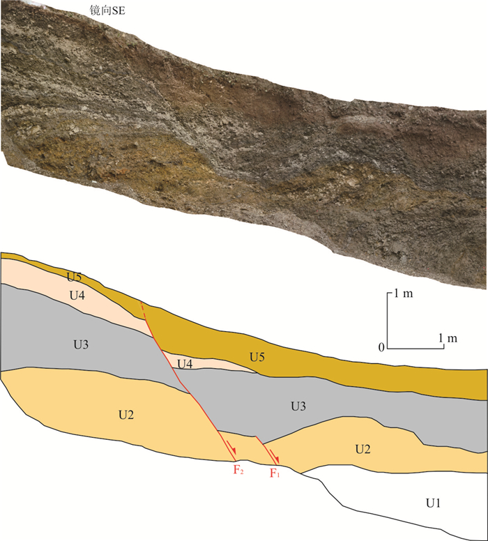
To reveal the internal tectonic deformation characteristics of the Bayan Har block, this paper studies the middle segment of the Wudaoliang-Changshagongma fault activity of the Late Quaternary based on seismic geological survey and new chronological methods. The geological and geomorphological evidences show that the middle segment of the Wudaoliang-Changshagongma fault is a Holocene left-lateral strike-slip fault, indicating that the fault has tectonic condition for generating strong earthquakes as one of the main faults inside the Bayan Har block. The latest paleoearthquake event on the middle segment of the fault occurred after (4 409-4 225) a BP. The elapsed time may be more than a thousand years. Moreover, small earthquakes have been active on this segment in the past two years. And a M5.6 earthquake occurred on it on April 1st, 2020. So, we should pay attention to the strong earthquake risk of the fault in the future.


The Luding ductile shear zone is the middle section of the north-south Daduhe fault and is an important part of the "Y" structure in Sichuan and Yunnan. The Sichuan-Tibet Railway Luding bridge spans the Luding ductile shear zone near Bairiba, Luding County, and the tunnel on the left bank crosses the No.5 mylonite belt. The composition and activity of the ductile shear zone directly affect major foundation projects. Based on the fine cataloguing of excavation profiles of flat tunnels and highways, and the identification of thin sections, the distribution characteristics, composition characteristics and fault activity of the Luding ductile shear zone were studied. The main conclusions are as follows: (1) The Luding ductile shear zone can be divided into five zones from west to east, among which ①, ③ and ⑤ are felsic mylonite belts, and ② and ④ are mylonitized amphibolites. The Luding segment of the Luding ductile shear zone is distributed at the bottom of the valley and the left bank of the bridge area, with a total width of about 1 000 m. The belts ① and ③ traverse the bridge site from north to south, the fault occurrence is N15°-20°E/NW∠55°-65°, the fault width is 500 m, mainly gray felsic mylonite and thousand mylonite. The belt ⑤ extends along the Taiyanggou-Wuligou and crosses the tunnel on the left bank. The occurrence is N43°E/NW∠54°, and the fault width is 500 m. Mylonite is felsic mylonite, zonal-small eyeball mylonite. (2) Cut by the fault zone, the structural joint density of the river reach is high, the number of groups and stages are many, the rock mass is broken, and the integrity of the rock mass is poor. (3) The Luding ductile shear zone was deformed by ductile shear in Jinning Period, and was transformed by brittle fractures since the Mesozoic, but no large-scale brittle fracture zone was formed. The overall impact on the Luding bridge was small, and the engineering effect was mainly manifested in the tunnels on both sides of the Dadu river. The stability of the inlet and outlet slopes is poor and the integrity of the surrounding rock in the left bank cave is poor.


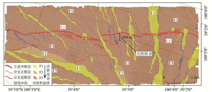
Slip distribution is necessary for the understanding and construction of rupture behavior along active faults. Although large number of researches have been focused on this issue using high-resolution topographic data, the slip distribution along immature active thrusts is still unclear. Two significantly different scenarios exist on this issue until this day. One is the large variation triangular distribution, and the other is comparatively uniform distribution. Using 8 km length, 2.5 km width and 0.5 m resolution UAV derived DEM data; we mapped in detail the geomorphic units, measured 73 vertical separations, and analyzed the parameters of the surface rupture. The Linze thrust is mainly composed of two left stepping branches, and the width of the step is ~260 m. The triangular slip distribution, with maximum and minimum vertical throws of 4.5 m and 0.2 m, respectively, reveals progressively lateral propagation of the thrust. The analysis of surface rupture parameters for the Linze thrust reveals the immature structure and the trend of connection and propagation of the segmented branches. Thus, more attention possibly should be paid to the influence of the propagation and connection of the thrust for the neighboring counties.


Coseismic displacement poses a serious threat to the safety of cross-fault projects such as the Sichuan-Tibet Railway, and a reasonable evaluation of the displacement parameters of active faults has important application value. Because traditional deterministic evaluation methods cannot distinguish the importance of engineering sites and their relative positions on the fault, more and more scholars recommend the use of probabilistic fault displacement hazard analysis (PFDHA). However, the principle of PFDHA based on classic probabilistic method is complicated and difficult to implement, which is not conducive to application of the latest results of fault seismic activity research, and it also hinders the popularization and promotion of PFDHA. Compared with the classic probabilistic method, Monte Carlo simulation has the advantages of clear and easy-to-understand logic, easy implementation, and good compatibility and scalability. In this study, a general algorithm for probabilistic fault displacement hazard analysis is realized based on Monte Carlo simulation, and the method is applied to the Luhuo section of the Xianshuihe fault zone. The results show that the results of PFDHA vary significantly with the level of exceeding probability or the relative position of engineering site points on the fault. The displacement parameters obtained by properly considering the uncertainty of the maximum displacement and surface rupture length are more reasonable. When the probability of exceedance is greater than or equal to 2% in 100 years, the results of PFDHA are significantly smaller than that of the deterministic method. However, as the fault activity increases, the result of 1% probability of exceeding in 100 years may be larger than that of the deterministic method. Selecting the corresponding PFDHA evaluation results according to the seismic fortification standards of different types of projects is not only beneficial to the safety of the project, but also helps to reduce the costs of most projects. Compared with the deterministic method, PFDHA has many advantages, and is expected to provide reasonable fault displacement parameters for major projects such as the Sichuan-Tibet Railway.


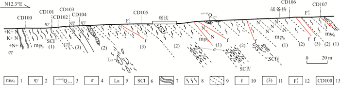
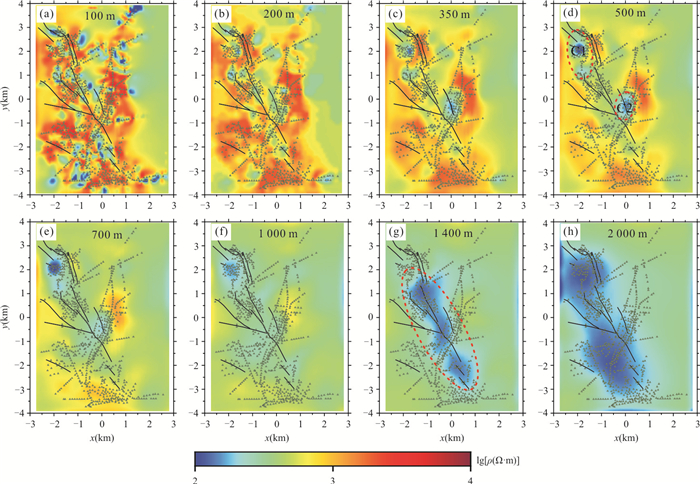
In order to avoid the geological hazards to the greatest extent in the processing of tunnel routes in the Selaha segment of the Sichuan-Tibet Railway line, we use audio magnetotelluric (AMT) data and obtain a reliable 3-D electrical structure model in the Salaha fault and adjacent area. The 3-D electrical resistivity model is comprehensively interpreted with the investigation of active faults. There is a large-scale high resistivity body at the depth from surface to 500 m, where the local area controlled by the faults is of low resistivity. Beneath the shallow 500 m, the resistivity decreases significantly, which results from the fault zone rich in aqueous fluids. In addition, there are two high conductors C1 and C2 in the study region; one is in the Mugecuo south stage area at the northwestern side of the Salaha fault, and the other is in the eastern side of the fault intersection area. These high conductors are presumed to be structural soft rocks. Therefore, it should be avoided as far as possible in designing the tunnel route.


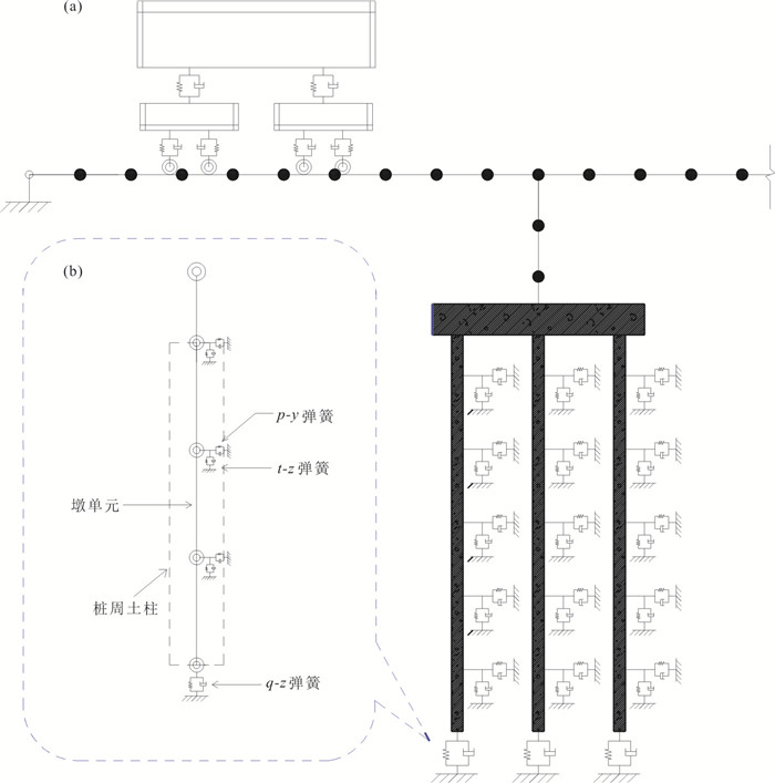
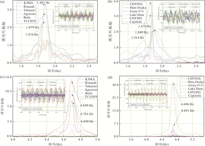
There is a growing worry about the impact of near-fault earthquakes on bridges. This paper presents a bridge-soil-pile foundation global modeling technique that stresses the actual advantages of more comprehensive abutment and soil nonlinearity, which may reflect physical events more accurately than a sequence of axial loads. The nonlinear soil-pile foundation model is established using p-y, t-z, and q-z curves and the SHAKE91 program. The bilinear model is employed to simulate the hysteretic characteristics of the pier and pile; the high-speed railway bridge-soil-pile model is established in this paper. The elastic-plastic seismic response of a high-speed railway bridge subjected to the near-fault ground motions and the Ap/vp ratio on the seismic response of the bridge-pile system is analyzed. The results indicate that the Ap/vp ratio influences the bridge's lateral and vertical response in different ways. In contrast with the fixed base bridge, the lateral response of the bridge decreases for the bridge-foundation system. On the other hand, for the same bridge-foundation system, the vertical response decreases when Ap/vp is greater than 10, which demonstrates the vertical NF ground motion impacts the seismic response of the bridge in the high-frequency range.


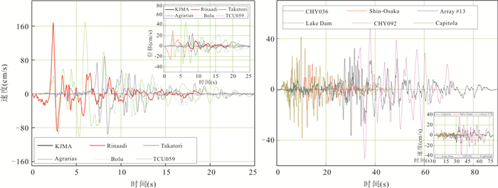


When constructing new railways in challenging tectonic zones, the influence of harsh situations like earthquakes on train traffic is increasingly being considered. With a time-domain solution approach, a numerical model of the coupled train-bridge-soil system is provided. In the poor geological development area, the elastic-plastic seismic response of the railroad train-bridge-soil coupled system is calculated using the p-y, t-z, and q-z curves. This means that bending the beam half-wave form reduces the inherent frequency of the coupled train-bridge-soil system, which is discovered to be the initial bending mode. After taking into account soil-structure interaction (SSI), the frequency components impacting the seismic response vary, and the frequency range widens as well as decreasing. The affecting frequency range is 1.8-2.0 Hz before SSI and 1.2-2.0 Hz after SSI, respectively. To design SSI, it is advised that the influence of vertical higher order vibration pattern should be addressed, since it varies from 4.576 Hz to 14.215 Hz before and after SSI consideration.


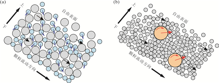
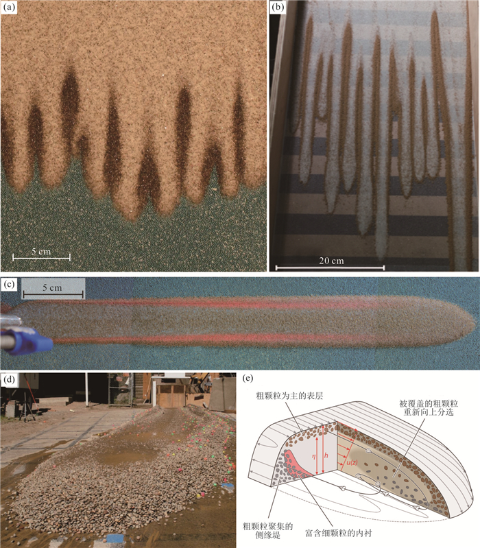
Granular flow is a main stage in the propagation of rock avalanches, which is of significant importance for revealing the hypermobility of rock avalanches. The main methods and theoretical achievements of granular flow can provide important technical means and theoretical basis for the study of rock avalanche dynamics. Focusing on the research of granular flows, its current research progress is reviewed firstly from the perspectives of its concept, flow regimes and corresponding constitutive models, and size-segregation mechanisms. Then, the granular flow theories and methods involved in rock avalanche research are systematically reviewed from the aspects of theoretical analysis, experiments and numerical modeling. On these bases, the key issues involved in the research of rock avalanche dynamics are proposed from the viewpoint of granular flow, i.e., what physical processes is related to the hypermobility of rock avalanche? How to quantify and model its polydispersity and fragmentation? How to quantitatively describe the temporal and spatial evolution of its grain size distribution and related coupling processes? How to retrieve its propagated mechanisms from the deposit? Facing these problems, future works that should be focused are proposed, including research on the physical processes of granular flow from sedimentology, on granular flow dynamics with scale effect considered, on the dynamic mechanisms and their constitutive models of rock avalanche based on the physical processes, and on the application of new technologies and methods.

High altitude rockfalls, as one of the common types of geological disasters in mountains, coasts, traffic corridors and opencast quarries, have the characteristics of wide distribution, sudden failure, concealment and severity of disaster, etc. In recent years, with frequent earthquakes and drastic climate change around the world, the high-altitude extremely-energetic rockfalls have increased significantly, causing serious loss of life and property. Recently, the identification and early warning technology, failure and transportation mechanism as well as disaster chain effects of high-altitude extremely-energetic rockfalls have become one of the research hotspots in the field of international geosciences. This paper summarizes the current main research achievements from the aspects of early identification of rockfalls, failure and transportation mechanism, comprehensive mitigation measures, and puts forward the scientific and technical problems that need to be solved urgently, such as damage identification method of rock bridges, dynamic monitoring technology, dynamic stability evaluation method, early warning model, transportation mechanism and comprehensive prevention and control technology. The solution of these problems will contribute to the comprehensive prevention and control of high-altitude extremely-energetic rockfalls.


Rock-ice avalanche is a special kind of rock avalanche involving ice, rock, and soil particles, which disintegrates from rock/ice avalanches or landslides in cold high-mountain regions. As involved ice, rock-ice avalanches have extremely high mobility and enormous destructive potential, under the background of global warming, the propagation mechanism of rock-ice avalanches is a frontier scientific issue in the field of geological disasters. The representative achievements in the field of rock-ice avalanches over last forty years were reviewed briefly. The terminology and definition of rock-ice avalanche were given. The formation mechanism and its climate sensitivity were investigated, and the regional development characteristics were analyzed. The propagation mechanism and the influence of ice were studied. The extremely high mobility of rock-ice avalanches was attributed to the low friction of icy surface, fluidization of meltwater, and channeling effects. The influence of ice is complicated by the low friction of icy surface and thermo-hydro-mechanical coupling. Further investigation should be conducted in the dynamic characteristics and propagation mechanism for improving relevant hazard mitigation.


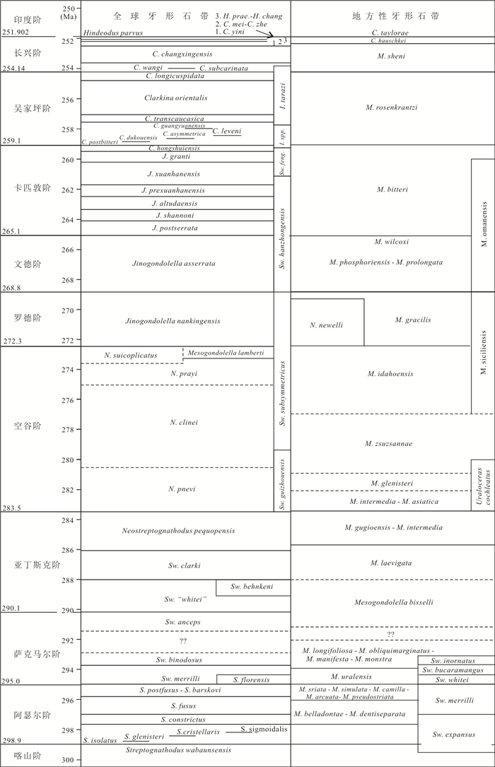
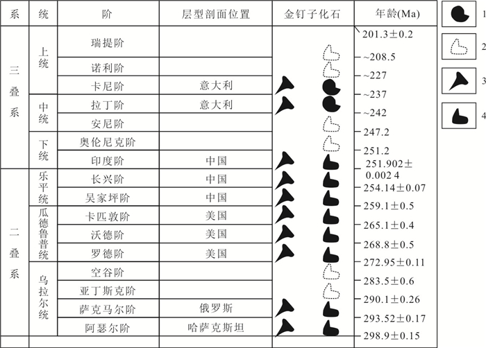
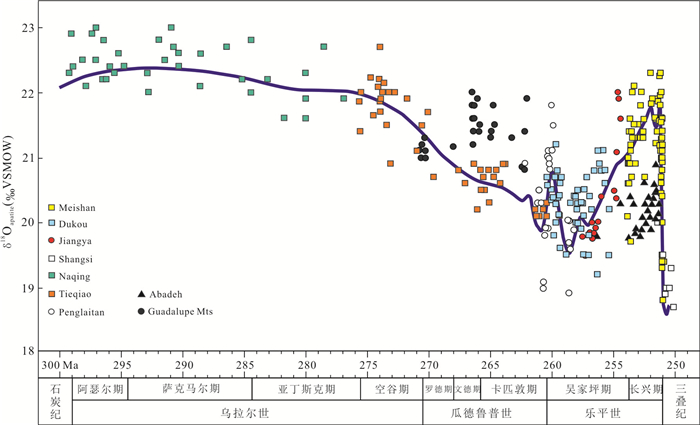
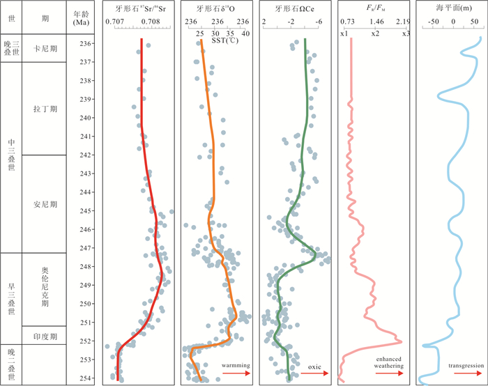
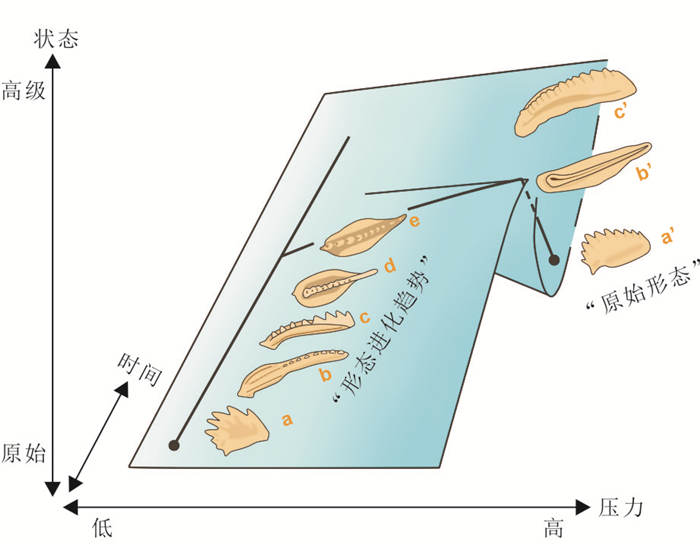
Numerous geological events took place during the Palaeozoic-Mesozoic upheavals, including breakup of the Pangea supercontinent, eruptions of large igneous provinces, ending of the Late Paleozoic Ice Age, extremely hot temperatures, two mass extinctions, and delayed ecosystem recovery. As the main index fossil of this interval, conodont is an important basis for stratigraphic correlation and the co-evolution history of organisms and the environment. In recent years, significant progress has been achieved through the study of Permian and Early Triassic conodonts and its related researches, which plays an important role in understanding the biotic and environment evolutions. The researches about Permian and Early Triassic conodonts have been summarized in this paper, including conodont biology, stratigraphy, and geochemistry. Moreover, some issues which have remained being overlooked or un-solved are also presented. In the future, the development of more technical approaches and the discoveries of more basic materials would be favored for more deep studies on the evolution of the conodont during this interval, which will further play an indispensable role in paleo-oceanic, paleo-environmental and paleontological studies during this transitional and mutational geologic history.


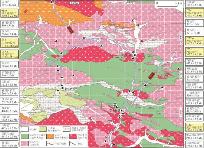
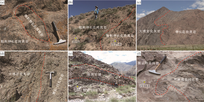
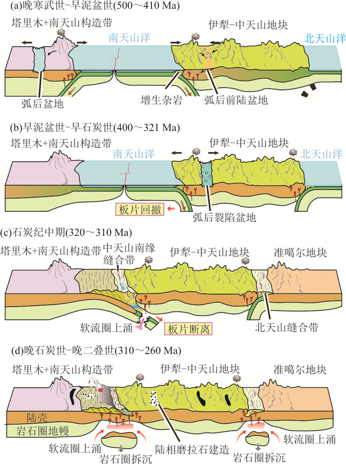
The Paleozoic tectonic evolution of the Tianshan orogenic belt, which is situated between the western Central Asian Orogenic Belt and the Tarim Craton, is still in heated debate. The widespread Paleozoic igneous rocks in the Tianshan orogen are a powerful tool to reveal the subduction and accretion processes as well as the tectonic switching. In this paper, detailed geochronological and geochemical studies were presented for seven suites of Paleozoic igneous rocks in the Baluntai domain of the Chinese western Tianshan. Zircon LA-ICP-MS U-Pb dating reveals that their crystallization ages are in the range of ca. 319-307 Ma, i.e., Late Carboniferous. Geochemical characteristics indicate that the Late Carboniferous mafic igneous rocks were mainly derived from asthenosphere mantle or subduction-modified lithospheric mantle; while the coeval granitoid rocks are generally metaluminous to weak peraluminous medium- and high-K calc-alkaline I-type granites that were mainly originated from partial melting of the lower crustal meta-basic rocks. In combination with the tempo-spatial distribution of the Paleozoic igneous rocks and published results of the metamorphic, ophiolitic and sedimentary rocks in the western Tianshan, we propose that the ca. 320-310 Ma igneous rocks were generated during slab breakoff, marking the tectonic transition from continental collision to post-collision settings. By inference, the subsequent 310-307 Ma magmatism was formed in a post-collisional extensional setting caused by lithospheric delamination.


Narong mining area is located in the southern margin of southern Qiangtang Block, providing an ideal window for understanding the tectonic-magmatic activities and mineralization of Bangong Co-Nujiang metallogenic belt. In this case study, we focus on the quartz diorite porphyries in the Narong mining area and report new zircon U-Pb ages, geochemical, zircon Hf and whole-rock Sr-Nd isotopic data. The results show that the Narong quartz diorite porphyries were emplaced during the Late Jurassic (158-155 Ma). Geochemically, the quartz diorite porphyry samples belong to calc-alkaline series. They are characterized by high Sr (178×10-6-1 086×10-6) contents, and high Sr/Y (15-82), (La/Yb)N (17-34) ratios with depletions of heavy rare earth elements (such as Yb=1.05×10⁻⁶-1.45×10⁻⁶, Y=10.50×10⁻⁶-14.78×10⁻⁶). These geochemical features are generally consistent with those of typical adakitic rocks. Additionally, the studied samples have lower MgO, Cr, Ni but higher Th and Th/U. Their zircon εHf(t) values are between -1.7 to +4.3, initial (87Sr/86Sr)i values are between 0.705 93-0.706 81 and the εNd(t) are between -2.67 to -0.49. These features, along with regional geological information, indicate that they are products of partial melting of thickened lower crust during slab subduction process. In combination with data from the middle and western segments of South Qiangtang, we infer that the Bangong Co-Nujiang Ocean subducted northward beneath the Qiangtang Block, forming a nearly E-W direction magma arc (> 1 200 km) during the Late Jurassic. The ore-forming intrusions in the Narong mining area and the Duolong ore concentration area have similar zircon Hf isotopic compositions, and zircon trace elements have high Ce/Ce* and Eu/Eu* ratios, and whole rock trace elements have high Sr/Y and V/Sc ratios, showing positive mineralization potential.


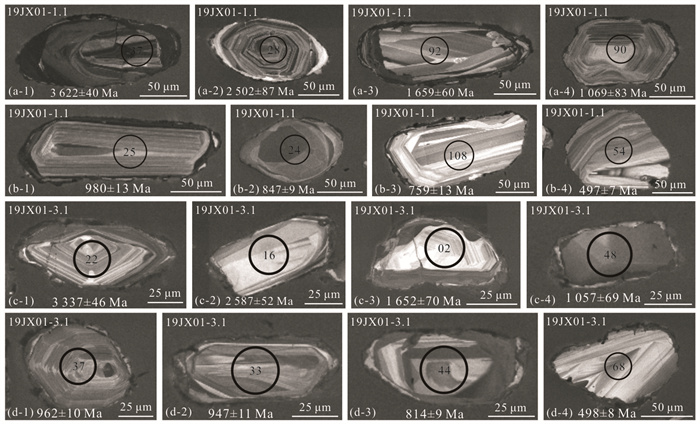
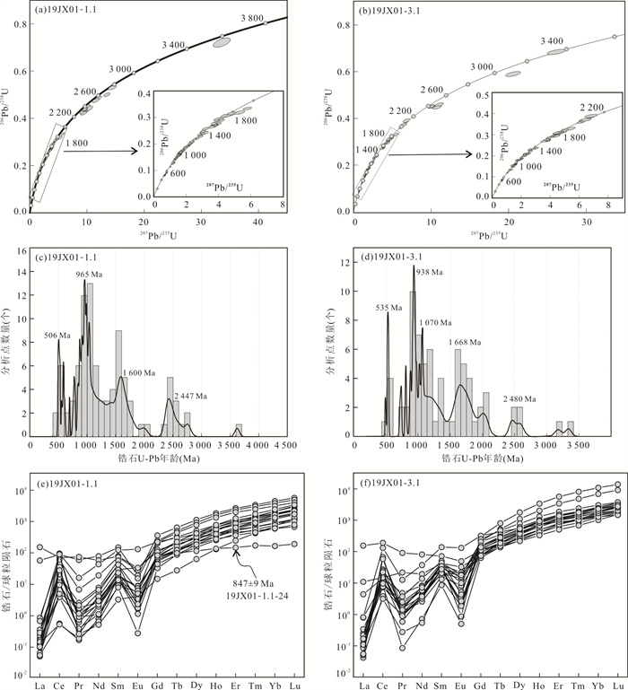
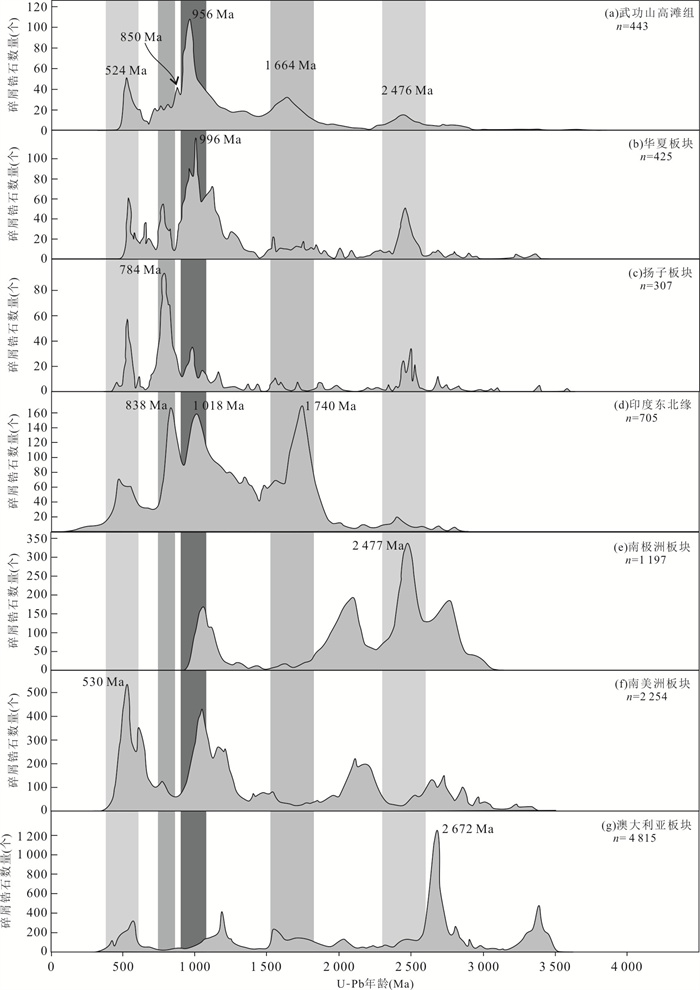
The Gaotan Formation, which has undergone greenschist to amphibolite facies metamorphism, is one of the most widely distributed Early Paleozoic strata units in the Wugongshan complex of Jiangxi Province. Depositional timing and provenance of the Gaotan Formation is vital for probing the Early Paleozoic crustal evolutionary of the Wugongshan complex. In this paper, LA-ICP-MS (laser ablation inductively coupled plasma mass spectrometry) was used to analyze the zircon U-Pb ages and rare earth element compositions of bearing-garnet micas quartz schist in the Gaotan Formation of the Wugongshan complex. The age of the youngest group of detrital zircons from the garnet-bearing micas quartz schist is 524±12 Ma, combined with geological relationship which the Gaotan Formation was intruded by the ca. 462 Ma granites in the Wugongshan complex, it is speculated that the depositional timing of the Gaotan formation is 524-462 Ma. Detrital zircon U-Pb ages of the Gaotan Formation range from 3 622 Ma to 497 Ma, with the main age peak of 956 Ma and four secondary age peaks of 2 456 Ma, 1 644 Ma, 850 Ma and 524 Ma, respectively. By comparing the detrital zircon ages of the Early Paleozoic sedimentary rocks in the Yangtze and Cathaysia blocks, the provenance characteristics of the Gaotan Formation are similar to the Early Paleozoic strata in the Cathaysia block, indicating that the Wugongshan complex was a part of the Cathaysia block during the Early Paleozoic.


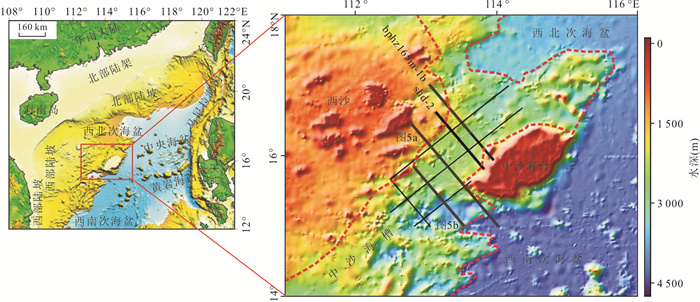
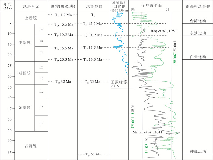
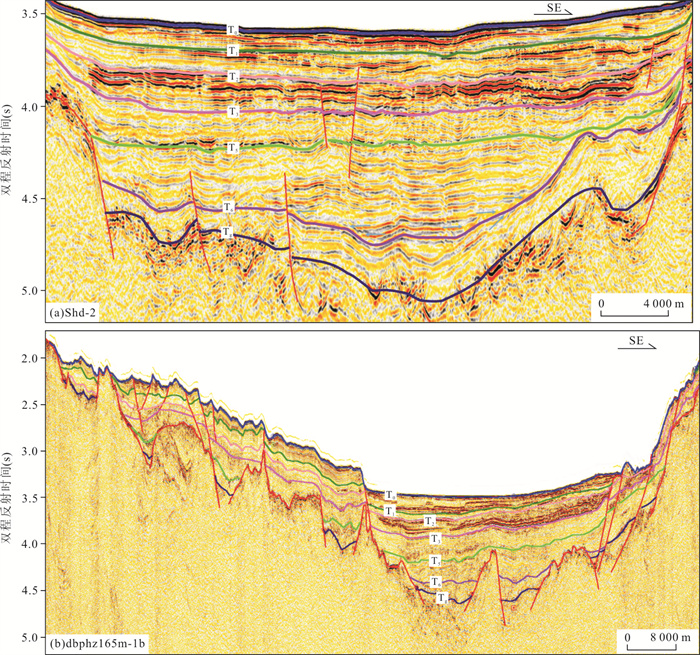
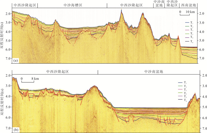
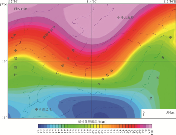
The basin evolution in distal rifting margin has been hotspot in the continental margin scientific planning. Zhongsha trough basin located between the Northwest Sub-Basin and Southwest Sub-Basin is a typical distal rifting basin nearby the ocean basin. In this study, the seismic sequence and tectonic have been unraveled based on the newly collected geophysical data. The basin has been filled with sediments of 200-1 500 m in thickness and 6 identified seismic sequences. Eogene sequence is limited at trough center; while Neogene sequence covered in the whole basin with thickness of 200-1 100 m. Quaternary sedimentary layer is thin hemipelagic deposits. The distal basin has three characters as follows. (1) Intensive magma activity occurred in the whole basin. It was characterized by a large amount of igneous intrusion and eruption on the seismic sections. (2) the rifting basin located over acoustic basement. It has magmatic feature and varied at 6.0-10.4 km buried depth. (3) Buried depth of Moho varies between 15 and 24 km. It is thinner seaward and thick to coral reefal islands. The tectonic deformation is characterized by rifting structures which included NE-SW and NW-SE trending faults, of which the NE-SW striking faults controlled the Cenozoic depression development.


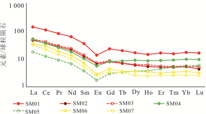
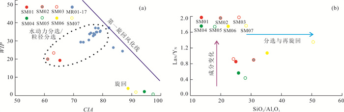
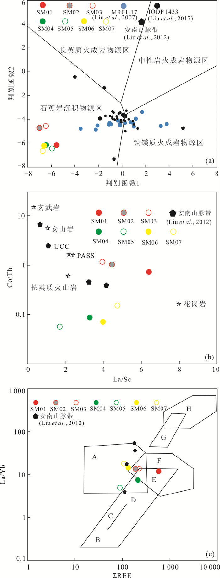
Originating from Qinghai-Tibet Plateau, the Mekong River is seventh longest river of the world, forming the Mekong River Delta in southwestern South China Sea. Due to lack of reliable geochemical data and systematic research, the properties of Quaternary sediments in the Mekong Delta are still unclear, which restricts further understanding of the source and sink system of the Mekong River. Based on the analysis of heavy minerals, geochemical characteristics of major elements and trace elements of samples from Mekong Delta, all the samples present negative chondrite-normalized Eu anomaly, indicating typical terrigenous deposition. With respect to the Pleistocene samples, the ZTR index ranges between 21 and 69. By contrast, the ZTR index of the Holocene samples ranges from 2 to 13. The correlation diagrams show that the Holocene samples are mainly affected by sorting and the Pleistocene samples are mainly affected by sedimentary recycling. The provenance of sediments from the Pleistocene with high component maturity was probably derived from eastern part of the Tibet, which has experienced several depositional recycling and have been transported by Paleo-Mekong River to the Delta. However, with low component maturity, the sediments of the Holocene are proximal source, and most likely from basement of Dalat area nearby. Variation of provenance of Mekong River Delta during different depositional periods may be related to the tectonic activities, depositional processes and evolution of the Mekong River and the Mekong River Delta in Quaternary.


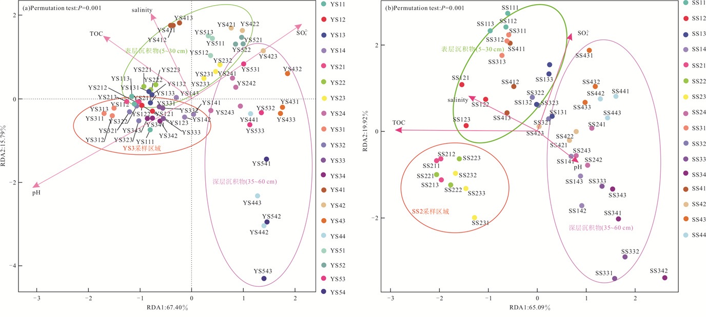
There are abundant microbial communities in mangrove cover and plain sediments. These microorganisms play a vital role in driving the biogeochemical process of mangrove wetlands. It is of great significance to understand the diversity and distribution characteristics of microorganisms in the Dongzhai port mangrove wetland sediments for exploring the biogeochemical process and ecological protection of the wetland. In this study, we collected 108 sediment samples from Yanfengxi River and Sanjiang River in Dongzhai port, and Illumina Miseq high-throughput sequencing technology was used to analyze their geochemical and microbial community characteristics, and the effects of different environmental factors on microbial communities were also discussed. The results show that Proteobacteria is the dominant bacteria species in the mangrove sediments of Dongzhai port, and the microbial abundance and diversity in the sediments generally decrease with depth. There are significant differences in microbial community structure between Yanfengxi River and Sanjiang River. pH is the main environmental factor controlling the microbial community structure in the sediments of plain area, while salinity is controlling the microbial community structure in the surface sediments of mangroves. The above research results show that microorganism distribution and community structure inDongzhai port mangrove sediments are influenced by human activities, and microbial abundance and diversity of the change trend of decrease with depth as a whole. There exist obvious differences in microbial community structure from different sediment sampling areas, as a result of the dual function of natural factors (such as salinity, pH) and human factors (aquaculture).


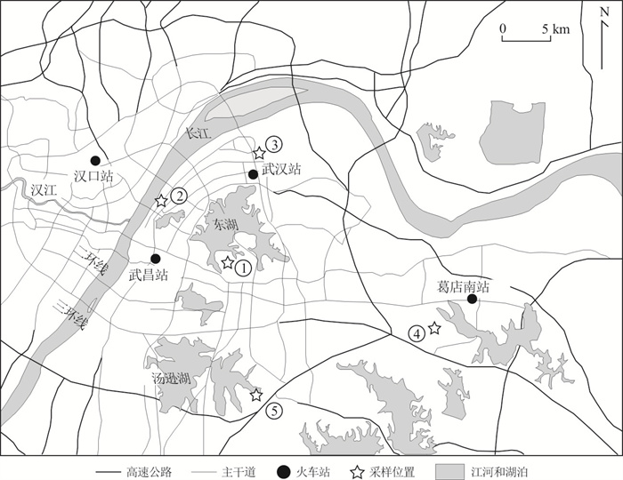
In order to understand the specific characteristics of atmospheric nitrogen deposition in different functional areas of Wuhan, the nitrogen contents and nitrogen isotope composition of camphor leaves and rhizosphere soil in five functional areas including urban traffic area, industrial area, educational area, suburban traffic area and educational area were analyzed. The nitrogen contents of camphor leaves near the urban road, factory and university campus were significantly higher than those of suburban university campus and road. Nitrogen isotopes of camphor leaves near urban road and factory are controlled by the nitrogen isotope composition of the nitrogen oxides (NOx) emitted by automobile exhaust and the ammonia nitrogen compounds (NHy) emitted by factory respectively. The δ15N values of the camphor leaves on suburban university campus are consistent with the values of the soil. The δ15N values of the urban university campus are negative, which may be affected by agricultural ammonia emission from nearby urban villages. The nitrogen contents and isotopic composition of camphor leaves are one of the effective ways to reveal the characteristics of atmospheric nitrogen deposition in Wuhan.