2022 Vol. 47, No. 6
Display Method:
 PDF 295KB
2022, 47(6): 1901-1916.
doi: 10.3799/dqkx.2022.205
Abstract:
China is one of the countries worst affected by landslides in the world, and great efforts have been made to detect potential landslides over wide regions. However, a recent government work report shows that 80% of the newly formed landslides occurred outside the areas labelled as potential landslides, and 80% of them occurred in remote rural areas with limited capability of disaster prevention and mitigation. To address this dilemma, there are urgent needs to (1) identify feasible detection techniques for each landslide type so as to minimize (if not avoid) the missing detection problem, and (2) engage local communities for landslide prevention to help landslide detection and risk assessment. To take full advantage of multi-source remote sensing data and technology, the potential landslides are divided into four types in this paper: actively deforming slopes, reactivated historically deformed slopes, stabilized historically deformed slopes, and undeformed but potentially unstable slopes. Furthermore, a multi-source remote sensing integrated technical framework is presented for landslide prevention, namely "wide-area potential landslide detection-risk assessment for individual potential landslides-community-based disaster prevention". In this study, a key section of the Qinghai-Tibet Plateau Transportation Project (QTPTP) with an area of about 10 000 km² was taken as the research area; collaborating with the local communities including some design and construction units of the QTPTP, it successfully identified 263 potential landslides, among which 249 were actively deforming slopes, 5 reactivated historically deformed slopes and 9 stabilized historically deformed slope. In addition, quantitative risk assessment and community-based disaster prevention were carried out for three typical potential landslides. It is believed that the multi-source remote sensing technical framework will not only help local communities improve their capability in landslide prevention, but also directly benefit to the construction and operation of the QTPTP.
China is one of the countries worst affected by landslides in the world, and great efforts have been made to detect potential landslides over wide regions. However, a recent government work report shows that 80% of the newly formed landslides occurred outside the areas labelled as potential landslides, and 80% of them occurred in remote rural areas with limited capability of disaster prevention and mitigation. To address this dilemma, there are urgent needs to (1) identify feasible detection techniques for each landslide type so as to minimize (if not avoid) the missing detection problem, and (2) engage local communities for landslide prevention to help landslide detection and risk assessment. To take full advantage of multi-source remote sensing data and technology, the potential landslides are divided into four types in this paper: actively deforming slopes, reactivated historically deformed slopes, stabilized historically deformed slopes, and undeformed but potentially unstable slopes. Furthermore, a multi-source remote sensing integrated technical framework is presented for landslide prevention, namely "wide-area potential landslide detection-risk assessment for individual potential landslides-community-based disaster prevention". In this study, a key section of the Qinghai-Tibet Plateau Transportation Project (QTPTP) with an area of about 10 000 km² was taken as the research area; collaborating with the local communities including some design and construction units of the QTPTP, it successfully identified 263 potential landslides, among which 249 were actively deforming slopes, 5 reactivated historically deformed slopes and 9 stabilized historically deformed slope. In addition, quantitative risk assessment and community-based disaster prevention were carried out for three typical potential landslides. It is believed that the multi-source remote sensing technical framework will not only help local communities improve their capability in landslide prevention, but also directly benefit to the construction and operation of the QTPTP.


2022, 47(6): 1917-1931.
doi: 10.3799/dqkx.2021.260
Abstract:
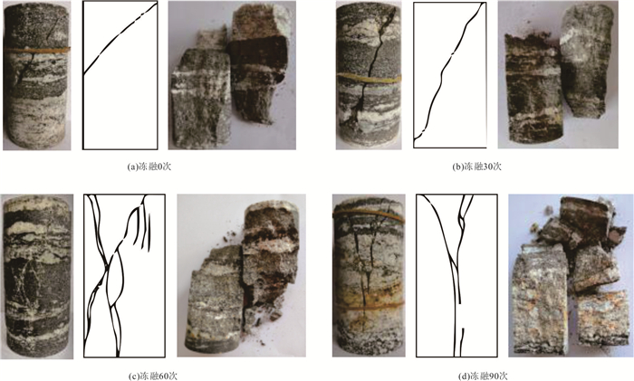
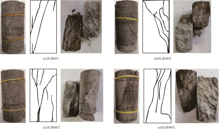
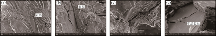
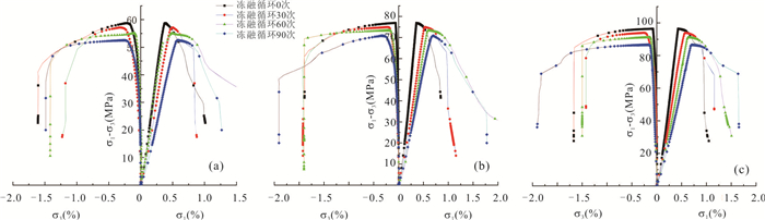
In order to explore the degradation law of typical rock along Sichuan-Tibet traffic corridor under freeze-thaw cycles, granite, gneiss and sandstone of Changdu-Linzhi section of Sichuan-Tibet traffic corridor were selected as the test objects, and the loading and unloading tests of rock with different freeze-thaw cycles were carried out. The results show follows: (1) With the increase of freeze-thaw cycles, the loss rate of rock compressive strength is 30%, the cohesion decreases by 18.4%, the internal friction angle decreases by 10.5%, the elastic modulus decreases gradually, and the Poisson's ratio increases gradually. (2) In triaxial compression test, the deformation modulus of rock sample presents the degradation law similar to compressive strength. Freeze-thaw action has the most obvious degradation effect on sandstone, followed by gneiss and granite, which is proportional to the compressive strength of rock, and the degradation range of deformation modulus is larger than that of compressive strength. (3) Compared with compression test, in unloading confining pressure test, freeze-thaw cycle also has degradation effect on unloading amount of rock, and the rock degradation is not obvious when the unloading degree is small. With the gradual increase of unloading amount, when the unloading amount is greater than 80%, the deformation modulus of rock decreases exponentially and the Poisson's ratio increases exponentially. (4) With the increase of freeze-thaw cycles, the number of cracks caused by tensile and shear failure increases in triaxial compression tests. The rock of unloading confining pressure test is mainly tensile failure. When the number of micro-cracks increases, the degree of irregularity increases, and the cementation state between mineral particles becomes worse. (5) According to the comprehensive test results, freeze-thaw action has the strongest deterioration effect on sandstone, followed by gneiss, and the weakest is granite.
In order to explore the degradation law of typical rock along Sichuan-Tibet traffic corridor under freeze-thaw cycles, granite, gneiss and sandstone of Changdu-Linzhi section of Sichuan-Tibet traffic corridor were selected as the test objects, and the loading and unloading tests of rock with different freeze-thaw cycles were carried out. The results show follows: (1) With the increase of freeze-thaw cycles, the loss rate of rock compressive strength is 30%, the cohesion decreases by 18.4%, the internal friction angle decreases by 10.5%, the elastic modulus decreases gradually, and the Poisson's ratio increases gradually. (2) In triaxial compression test, the deformation modulus of rock sample presents the degradation law similar to compressive strength. Freeze-thaw action has the most obvious degradation effect on sandstone, followed by gneiss and granite, which is proportional to the compressive strength of rock, and the degradation range of deformation modulus is larger than that of compressive strength. (3) Compared with compression test, in unloading confining pressure test, freeze-thaw cycle also has degradation effect on unloading amount of rock, and the rock degradation is not obvious when the unloading degree is small. With the gradual increase of unloading amount, when the unloading amount is greater than 80%, the deformation modulus of rock decreases exponentially and the Poisson's ratio increases exponentially. (4) With the increase of freeze-thaw cycles, the number of cracks caused by tensile and shear failure increases in triaxial compression tests. The rock of unloading confining pressure test is mainly tensile failure. When the number of micro-cracks increases, the degree of irregularity increases, and the cementation state between mineral particles becomes worse. (5) According to the comprehensive test results, freeze-thaw action has the strongest deterioration effect on sandstone, followed by gneiss, and the weakest is granite.


2022, 47(6): 1932-1944.
doi: 10.3799/dqkx.2021.205
Abstract:
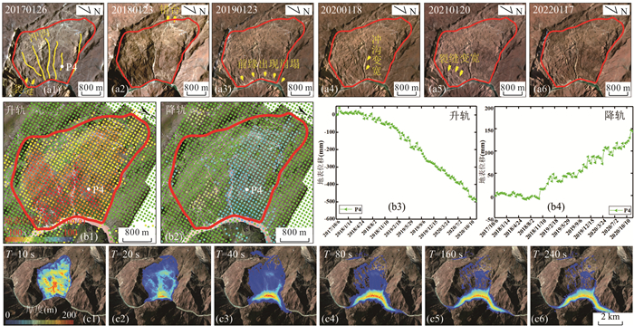
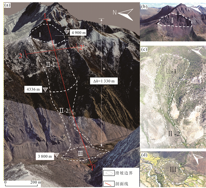
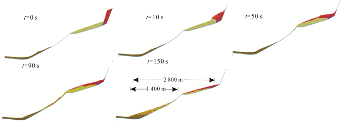
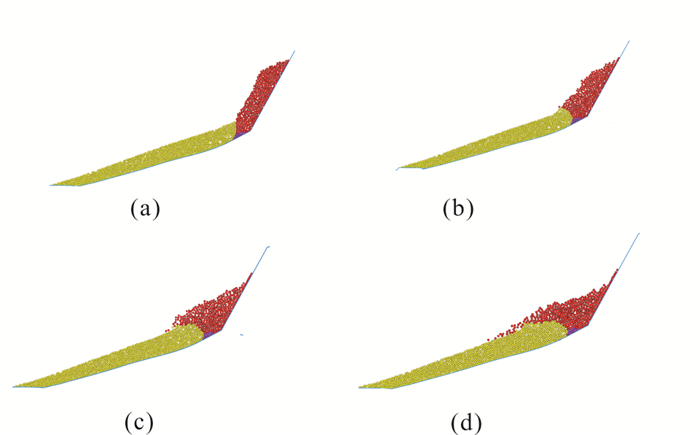
To understand the kinetic mechanism of Chada rock avalanche in Tibet plateau, remote sensing mapping, UAV topographic mapping and field survey data are used to zone the rock avalanche and research the formation mechanism of the rock avalanche. PFC2D numerical simulation is used to analyze the rock avalanche movement process under the seismic conditions simulation. The Chada rock avalanche can be divided into source zone, transition zone and accumulation zone. The average movement speed of this rock avalanche is 15-20 m/s. Its duration time is 150 s, and the maximum movement distance is 2 800 m. The Chada rock avalanche was induced by earthquake. The source zone rock mass scrapes and moves the trailing edge of the upper accumulation which resulting in the overall deformation of the upper accumulation. Its movement process can be divided into four stages: collapse → scraping → sliding → emplacement.
To understand the kinetic mechanism of Chada rock avalanche in Tibet plateau, remote sensing mapping, UAV topographic mapping and field survey data are used to zone the rock avalanche and research the formation mechanism of the rock avalanche. PFC2D numerical simulation is used to analyze the rock avalanche movement process under the seismic conditions simulation. The Chada rock avalanche can be divided into source zone, transition zone and accumulation zone. The average movement speed of this rock avalanche is 15-20 m/s. Its duration time is 150 s, and the maximum movement distance is 2 800 m. The Chada rock avalanche was induced by earthquake. The source zone rock mass scrapes and moves the trailing edge of the upper accumulation which resulting in the overall deformation of the upper accumulation. Its movement process can be divided into four stages: collapse → scraping → sliding → emplacement.


2022, 47(6): 1945-1956.
doi: 10.3799/dqkx.2022.155
Abstract:
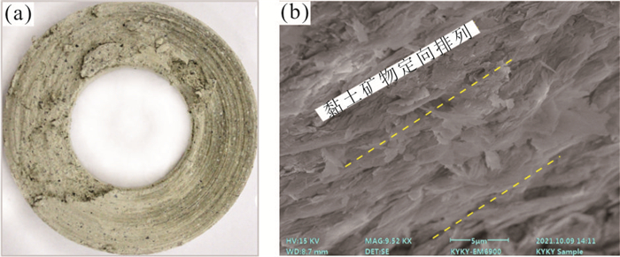
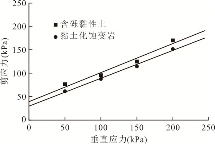
Clayey altered rock is a special geological body with poor engineering geological properties formed under hydrothermal action or hydrothermal action after the magmatic period. Based on field geological survey, clay mineral identification, and physical mechanics test analysis, the formation conditions, regional distribution characteristics, geological characteristics and the criterion of alteration degree of clayey altered rocks in the Sichuan-Tibet traffic corridor are described. Taking Baige landslide as an example, the sliding promotion of clayey altered rock on large-scale landslides are discussed. The results show that the regional distribution of clayey altered rocks is controlled by active faults, hydrothermal action and lithology. The clayey altered rocks often develop along intrusive dikes, fault zones, concentrated joint zones of magmatic rocks, and contact zones between intrusive rock mass and other rock formation. According to the alteration coefficient, the degree of alteration can be divided into four grades: very low alteration, low alteration, medium alteration and high alteration. In alternating wet and dry conditions and relaxation conditions, the altered rock is easy to disintegrate and soften. The medium-high altered rock mass usually has low shearing strength. The promoting effect of clayey altered rock on landslide is mainly reflected in three aspects: strength weakening effect, rock mass structure deterioration effect and instability hysteresis effect, which is an important factor in promoting the instability of slopes and large-scale landslides in deep-cut valley slopes in tectonic melange belts.
Clayey altered rock is a special geological body with poor engineering geological properties formed under hydrothermal action or hydrothermal action after the magmatic period. Based on field geological survey, clay mineral identification, and physical mechanics test analysis, the formation conditions, regional distribution characteristics, geological characteristics and the criterion of alteration degree of clayey altered rocks in the Sichuan-Tibet traffic corridor are described. Taking Baige landslide as an example, the sliding promotion of clayey altered rock on large-scale landslides are discussed. The results show that the regional distribution of clayey altered rocks is controlled by active faults, hydrothermal action and lithology. The clayey altered rocks often develop along intrusive dikes, fault zones, concentrated joint zones of magmatic rocks, and contact zones between intrusive rock mass and other rock formation. According to the alteration coefficient, the degree of alteration can be divided into four grades: very low alteration, low alteration, medium alteration and high alteration. In alternating wet and dry conditions and relaxation conditions, the altered rock is easy to disintegrate and soften. The medium-high altered rock mass usually has low shearing strength. The promoting effect of clayey altered rock on landslide is mainly reflected in three aspects: strength weakening effect, rock mass structure deterioration effect and instability hysteresis effect, which is an important factor in promoting the instability of slopes and large-scale landslides in deep-cut valley slopes in tectonic melange belts.


2022, 47(6): 1957-1968.
doi: 10.3799/dqkx.2021.204
Abstract:
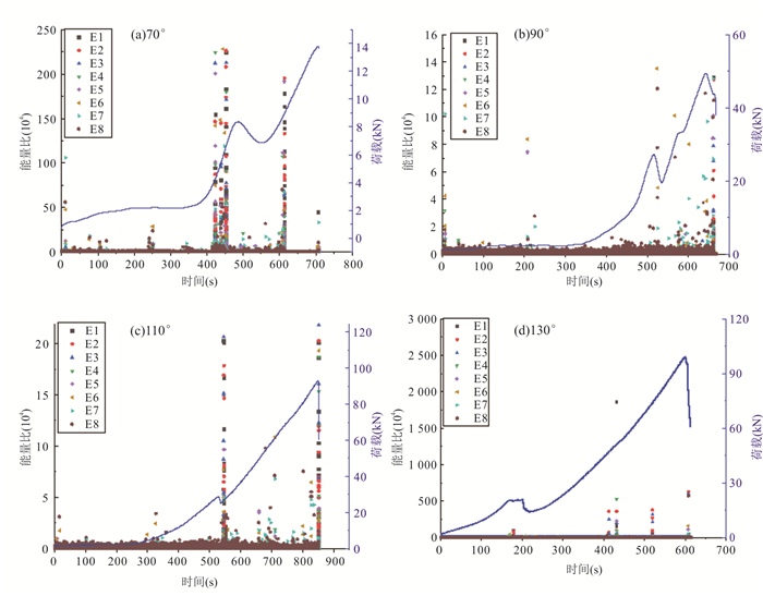
In order to research the energy and frequency distribution characteristics of microseismic signals and the critical slowdown phenomenon in the damage and destruction process of granite locked section slope model, the damage test study of granite locked section slope model was carried out, and the granite locked section slope model with different rock bridge angles was loaded by uniaxial loading system, simultaneous observation was carried out by strain gauges and microseismic (MS) monitoring system. The test results manifest follows: (1) the rock bridge angle affects the damage form of the slope model, when the rock bridge angle is 70° and 90°, the damage form is mainly tension damage. When the rock bridge angle is 110°, it is mixed tension and compression damage. When the rock bridge angle is 130°, it is compression-shear damage, and the leading edge creep-slip section is the largest part of the locked slope deformation. (2) In the loading process, when there is a small damage rupture, mainly high-frequency, low-energy microseismic signals are dominant, and when a large-scale damage rupture is generated, it will be accompanied by low-frequency, high-energy microseismic signals. (3) The critical slowdown phenomenon occurs when the slope model in the locked section is in the critical damage state, which is manifested by the sudden increase of the variance and autocorrelation of the microseismic signal, and the time corresponding to the sudden increase reaches 80% of the destabilization time, so it has good timeliness, and the sudden increase of the variance and autocorrelation coefficient of the microseismic signal can be taken as the precursor information of the destabilization damage of the slope model. (4) The energy ratio method and critical slowing theory form a joint prediction criterion, which can overcome the shortcomings of single criterion and improve the accuracy of prediction. This study can provide usable reference values for monitoring and early warning of rocky slopes of sudden occurrence type.
In order to research the energy and frequency distribution characteristics of microseismic signals and the critical slowdown phenomenon in the damage and destruction process of granite locked section slope model, the damage test study of granite locked section slope model was carried out, and the granite locked section slope model with different rock bridge angles was loaded by uniaxial loading system, simultaneous observation was carried out by strain gauges and microseismic (MS) monitoring system. The test results manifest follows: (1) the rock bridge angle affects the damage form of the slope model, when the rock bridge angle is 70° and 90°, the damage form is mainly tension damage. When the rock bridge angle is 110°, it is mixed tension and compression damage. When the rock bridge angle is 130°, it is compression-shear damage, and the leading edge creep-slip section is the largest part of the locked slope deformation. (2) In the loading process, when there is a small damage rupture, mainly high-frequency, low-energy microseismic signals are dominant, and when a large-scale damage rupture is generated, it will be accompanied by low-frequency, high-energy microseismic signals. (3) The critical slowdown phenomenon occurs when the slope model in the locked section is in the critical damage state, which is manifested by the sudden increase of the variance and autocorrelation of the microseismic signal, and the time corresponding to the sudden increase reaches 80% of the destabilization time, so it has good timeliness, and the sudden increase of the variance and autocorrelation coefficient of the microseismic signal can be taken as the precursor information of the destabilization damage of the slope model. (4) The energy ratio method and critical slowing theory form a joint prediction criterion, which can overcome the shortcomings of single criterion and improve the accuracy of prediction. This study can provide usable reference values for monitoring and early warning of rocky slopes of sudden occurrence type.


2022, 47(6): 1969-1984.
doi: 10.3799/dqkx.2021.194
Abstract:
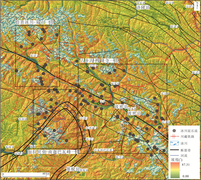
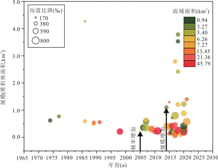
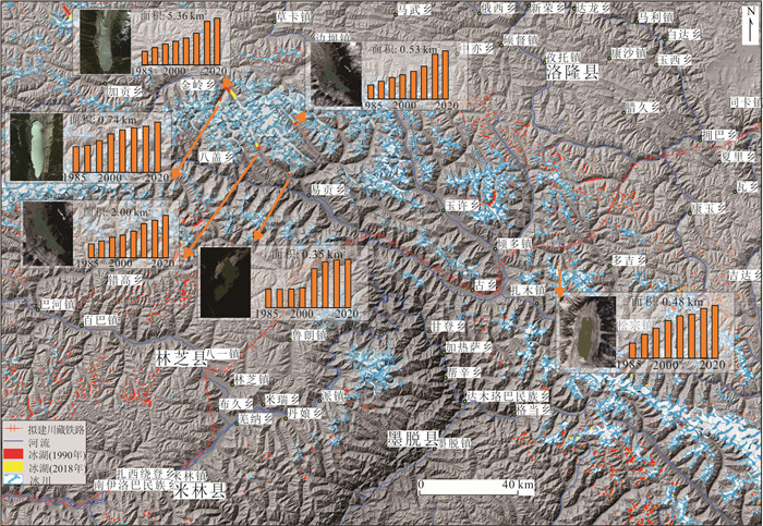
The Sichuan-Tibet traffic corridor is an important transportation strategy in China that plays a key role in the economic prosperity, long-term stability, and the "Belt and Road" strategy in western China. However, the complex terrain, climate environment and active geological tectonic movements along the Sichuan-Tibet traffic corridor lead to extremely developed geo-hazards, such as debris flows, landslides, glacial lake outbreak floods (GLOF), which have serious impacts on railway construction and operation. As a representative section, the Linzhi-Bomi is frequently affected by glacier debris flows, and deemed as the most difficult section for disaster mitigation. Although some conclusions about influencing factors and material properties of glacial debris flows have been achieved at the single-valley scale, there is lacking solid research on predisposing factors, evolution laws and catastrophe indicators of different types of glacial debris flows along the Sichuan-Tibet traffic corridor, making it impossible to build an effective monitoring and early warning system. In this paper, multi-source long-term remote sensing images and meteorological monitoring data, combined with field data, are applied to conduct an inductive analysis of the glacial debris flow along the Sichuan-Tibet traffic corridor. Four conclusions can be drawn. (1) 99 glacial debris flow valleys were identified in the study area, that mainly distributed in the Chaqing glacier-Yigong township, Jialabelei-Nangabawa peak, and Guxiang gully-Galongsi glacier. (2) Climate environment change has led to complex responses in glacier activities, characterised by increased activity of smaller glaciers (high-altitude hanging glaciers) and weakened activity of glaciers in large valleys in the past 40 years; (3) Based on the historic inventory, it can be found that the glacial debris flow has shown the characteristics of increasing frequency and scale since 1973. And (4) the frequency of the debris flows induced by landslides and ice-rock avalanches in steep terrain has increased. In the future, the continuous retreat of glaciers will promote the disappearance of ice waterfalls and the development of larger-scale hanging glaciers, which will increase the risk of glacial debris flows. The evolution process of glacial debris flows has obvious catastrophic indicators, such as: the increasing crevice density, the change in glacier velocities, and the rapid increase of glacial lake areas. Finally, it proposes a monitoring and early warning framework that contains satellites, aerial remote sensing platforms, meteorological and hydrological ground monitoring platforms, and ground motion monitoring platforms, which can provide catastrophic information for different types of glacial debris flows.
The Sichuan-Tibet traffic corridor is an important transportation strategy in China that plays a key role in the economic prosperity, long-term stability, and the "Belt and Road" strategy in western China. However, the complex terrain, climate environment and active geological tectonic movements along the Sichuan-Tibet traffic corridor lead to extremely developed geo-hazards, such as debris flows, landslides, glacial lake outbreak floods (GLOF), which have serious impacts on railway construction and operation. As a representative section, the Linzhi-Bomi is frequently affected by glacier debris flows, and deemed as the most difficult section for disaster mitigation. Although some conclusions about influencing factors and material properties of glacial debris flows have been achieved at the single-valley scale, there is lacking solid research on predisposing factors, evolution laws and catastrophe indicators of different types of glacial debris flows along the Sichuan-Tibet traffic corridor, making it impossible to build an effective monitoring and early warning system. In this paper, multi-source long-term remote sensing images and meteorological monitoring data, combined with field data, are applied to conduct an inductive analysis of the glacial debris flow along the Sichuan-Tibet traffic corridor. Four conclusions can be drawn. (1) 99 glacial debris flow valleys were identified in the study area, that mainly distributed in the Chaqing glacier-Yigong township, Jialabelei-Nangabawa peak, and Guxiang gully-Galongsi glacier. (2) Climate environment change has led to complex responses in glacier activities, characterised by increased activity of smaller glaciers (high-altitude hanging glaciers) and weakened activity of glaciers in large valleys in the past 40 years; (3) Based on the historic inventory, it can be found that the glacial debris flow has shown the characteristics of increasing frequency and scale since 1973. And (4) the frequency of the debris flows induced by landslides and ice-rock avalanches in steep terrain has increased. In the future, the continuous retreat of glaciers will promote the disappearance of ice waterfalls and the development of larger-scale hanging glaciers, which will increase the risk of glacial debris flows. The evolution process of glacial debris flows has obvious catastrophic indicators, such as: the increasing crevice density, the change in glacier velocities, and the rapid increase of glacial lake areas. Finally, it proposes a monitoring and early warning framework that contains satellites, aerial remote sensing platforms, meteorological and hydrological ground monitoring platforms, and ground motion monitoring platforms, which can provide catastrophic information for different types of glacial debris flows.


2022, 47(6): 1999-2014.
doi: 10.3799/dqkx.2021.161
Abstract:
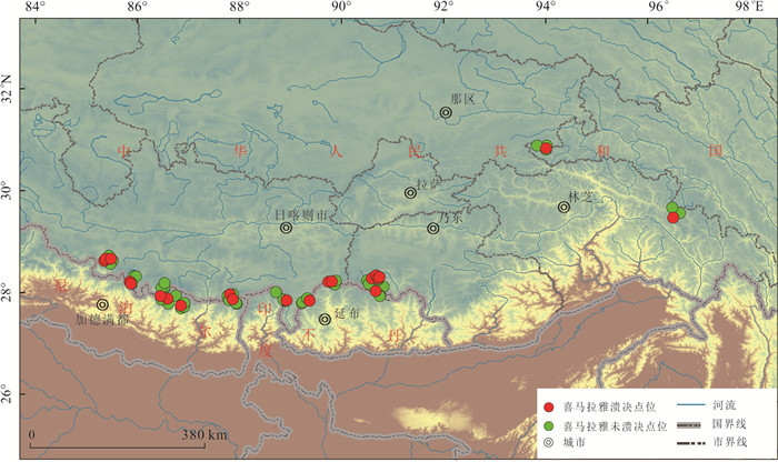
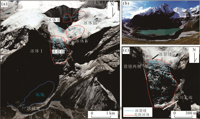
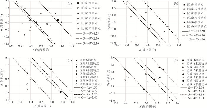
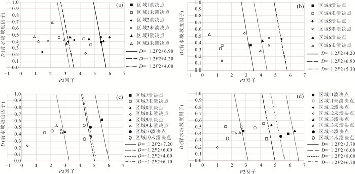
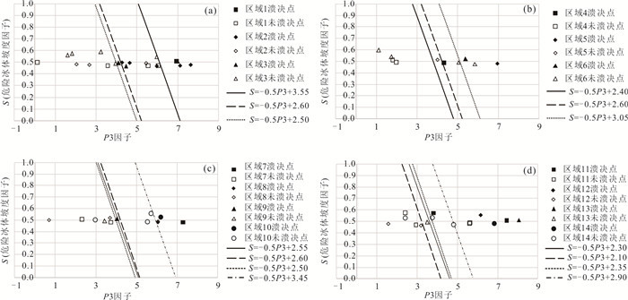
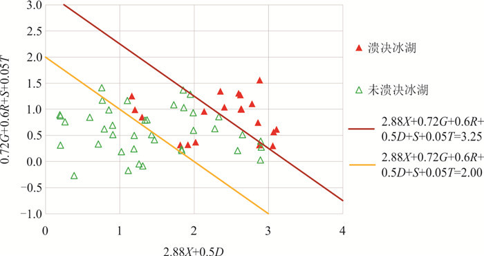
Glacial lake outburst floods (GLOFs) have caused tens of millions of dollars of damage to infrastructure and have killed thousands of people worldwide. Based on the formation mechanism of GLOF of moraine-dammed lakes without ice core, 21 GLOFs were selected for the analysis of triggering factors in the Himalayan region. A statistical method was used via the Variable-Controlling Approach (VCA). Six dimensionless impact factors can be used to reasonably assess the GLOFs susceptibility in the Himalayan mountains, southwestern part of Canadian Columbia and northwestern part of the United States, but the threshold values in the Himalayan mountains are larger than those in southwestern part of Canadian Columbia. The dangerous glacier slope factor, the dangerous glacier temperature factor, the glacier aspect factor, the dangerous glacier volume and lake volume factor, the dangerous glacier and lake kinetic factor, and the downstream slope of the moraine-dam factor are major factors for the breaching of moraine-dammed lake and GLOF. The assessment model with these factors may thus be used to assess the hazard of GLOFs occurrence in other areas.
Glacial lake outburst floods (GLOFs) have caused tens of millions of dollars of damage to infrastructure and have killed thousands of people worldwide. Based on the formation mechanism of GLOF of moraine-dammed lakes without ice core, 21 GLOFs were selected for the analysis of triggering factors in the Himalayan region. A statistical method was used via the Variable-Controlling Approach (VCA). Six dimensionless impact factors can be used to reasonably assess the GLOFs susceptibility in the Himalayan mountains, southwestern part of Canadian Columbia and northwestern part of the United States, but the threshold values in the Himalayan mountains are larger than those in southwestern part of Canadian Columbia. The dangerous glacier slope factor, the dangerous glacier temperature factor, the glacier aspect factor, the dangerous glacier volume and lake volume factor, the dangerous glacier and lake kinetic factor, and the downstream slope of the moraine-dam factor are major factors for the breaching of moraine-dammed lake and GLOF. The assessment model with these factors may thus be used to assess the hazard of GLOFs occurrence in other areas.


2022, 47(6): 2048-2057.
doi: 10.3799/dqkx.2022.069
Abstract:
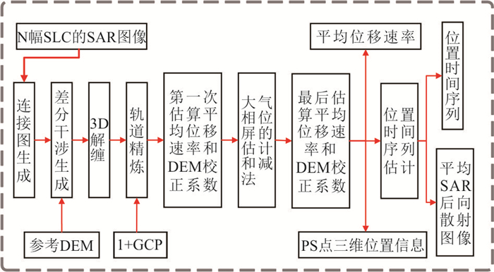
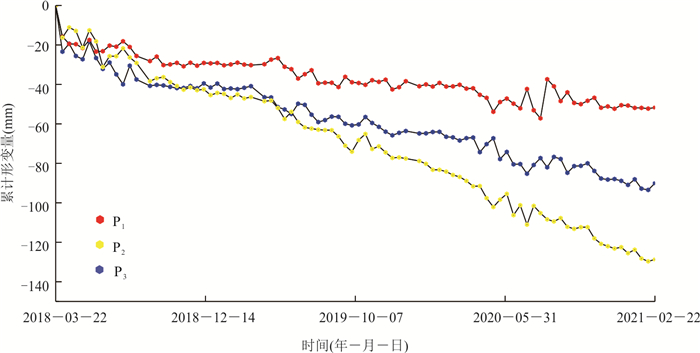
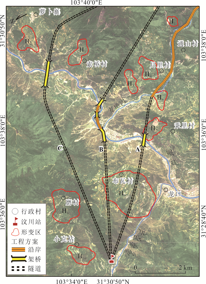
The complex geological structure in the southwest mountainous area leads to the distribution of many landslides. Early landslide identification is essential to guide road route selection scientifically and effectively and avoid the high risk of geological disaster in advance. Interferometry Synthetic Aperture Radar (InSAR) is widely used in the early identification of landslides due to its all-weather and multi-temporal characteristics. In this paper, 87 sentinel-1A orbital descent data are collected. The small baseline subset interferometric synthetic aperture radar (SBAS-InSAR) is used to identify and analyze the potential landslide hazard in the Wenchuan section of Chengwen expressway. 10 deformation areas were identified through the SBAS-InSAR, which after field validation are landslides under continuous deformation. This conclusion corresponds to the actual case. Based on early identification results, three schemes are compared and analyzed, and scheme B is optimal. SBAS-InSAR can effectively identify potential landslide hazard areas of mountain roads and provide scientific support for accurate route selection of mountain expressways.
The complex geological structure in the southwest mountainous area leads to the distribution of many landslides. Early landslide identification is essential to guide road route selection scientifically and effectively and avoid the high risk of geological disaster in advance. Interferometry Synthetic Aperture Radar (InSAR) is widely used in the early identification of landslides due to its all-weather and multi-temporal characteristics. In this paper, 87 sentinel-1A orbital descent data are collected. The small baseline subset interferometric synthetic aperture radar (SBAS-InSAR) is used to identify and analyze the potential landslide hazard in the Wenchuan section of Chengwen expressway. 10 deformation areas were identified through the SBAS-InSAR, which after field validation are landslides under continuous deformation. This conclusion corresponds to the actual case. Based on early identification results, three schemes are compared and analyzed, and scheme B is optimal. SBAS-InSAR can effectively identify potential landslide hazard areas of mountain roads and provide scientific support for accurate route selection of mountain expressways.


2022, 47(6): 2058-2068.
doi: 10.3799/dqkx.2022.050
Abstract:
Land surface soil moisture affects the land-air energy exchange and the water cycle, which is an important factor for geohazards such as debris flow and freeze-thaw of permafrost. Obtaining soil moisture along the Sichuan-Tibet traffic corridor corridor contributes to study climate change and the risk of cryospheric hazards along the railway. In this study, CYGNSS(cyclone global navigation satellite system) GNSS-R(global navigation satellite system reflectometry) signals, combined with land cover, normalized differential vegetation index (NDVI), land surface roughness, and other surface soil moisture influencing factors, are taken as input parameters to the artificial neural network method to establish a multi-parameter inversion model of surface soil moisture. Then it generates a daily product of surface soil moisture with a spatial resolution of 36 km in the area along the Sichuan-Tibet railway for two consecutive years from 2018 to 2019. With soil moisture active and passive (SMAP) soil moisture as references, the correlation coefficient R of the soil moisture is 0.8, the root mean square error (RMSE) is 0.032 cm3/cm3, and the Bias is 0.014 cm3/cm3. The soil moisture products could provide continuous and reliable data for the study of climate change and land surface hazards along the Sichuan-Tibet traffic corridor.
Land surface soil moisture affects the land-air energy exchange and the water cycle, which is an important factor for geohazards such as debris flow and freeze-thaw of permafrost. Obtaining soil moisture along the Sichuan-Tibet traffic corridor corridor contributes to study climate change and the risk of cryospheric hazards along the railway. In this study, CYGNSS(cyclone global navigation satellite system) GNSS-R(global navigation satellite system reflectometry) signals, combined with land cover, normalized differential vegetation index (NDVI), land surface roughness, and other surface soil moisture influencing factors, are taken as input parameters to the artificial neural network method to establish a multi-parameter inversion model of surface soil moisture. Then it generates a daily product of surface soil moisture with a spatial resolution of 36 km in the area along the Sichuan-Tibet railway for two consecutive years from 2018 to 2019. With soil moisture active and passive (SMAP) soil moisture as references, the correlation coefficient R of the soil moisture is 0.8, the root mean square error (RMSE) is 0.032 cm3/cm3, and the Bias is 0.014 cm3/cm3. The soil moisture products could provide continuous and reliable data for the study of climate change and land surface hazards along the Sichuan-Tibet traffic corridor.


2022, 47(6): 2069-2080.
doi: 10.3799/dqkx.2021.300
Abstract:
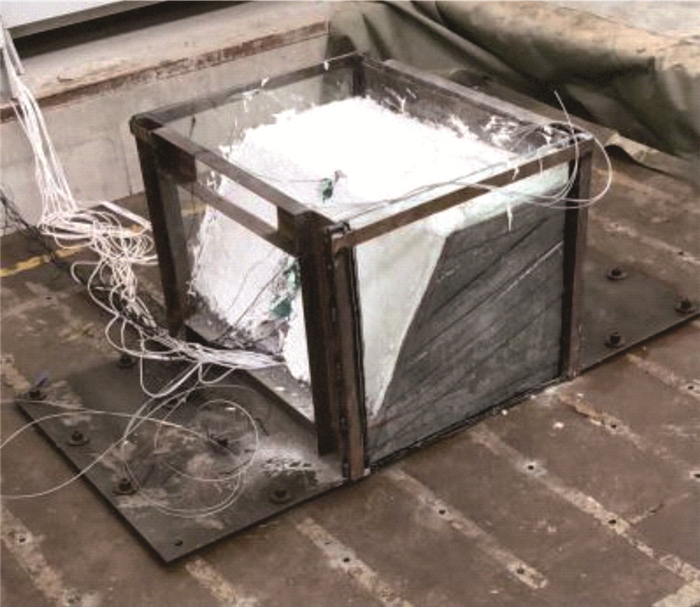
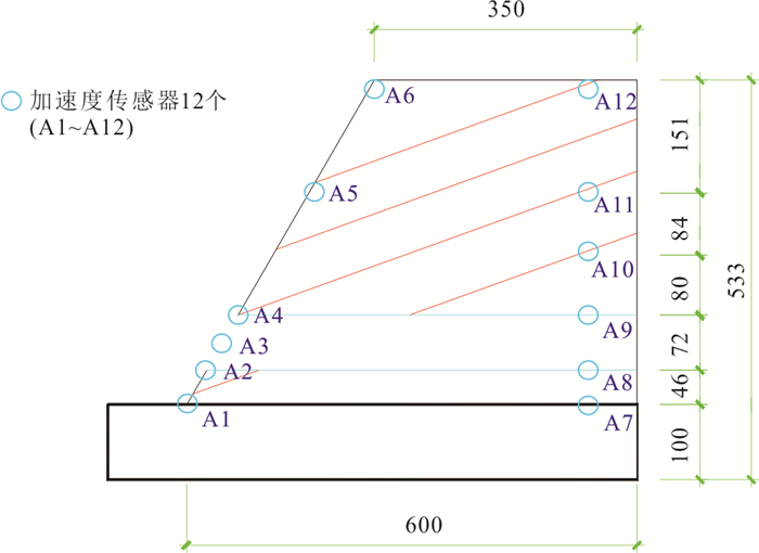
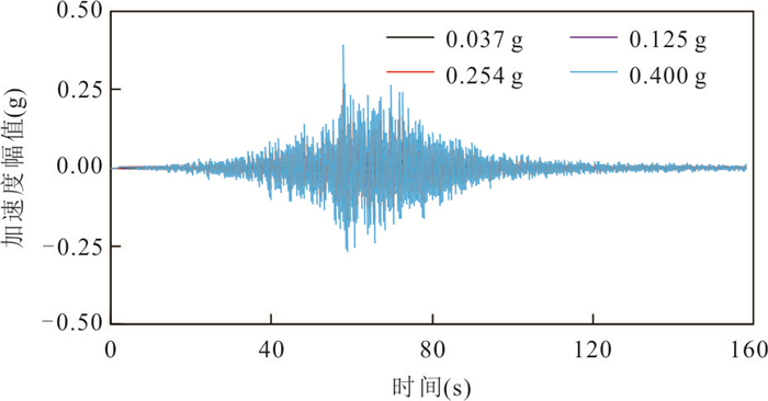
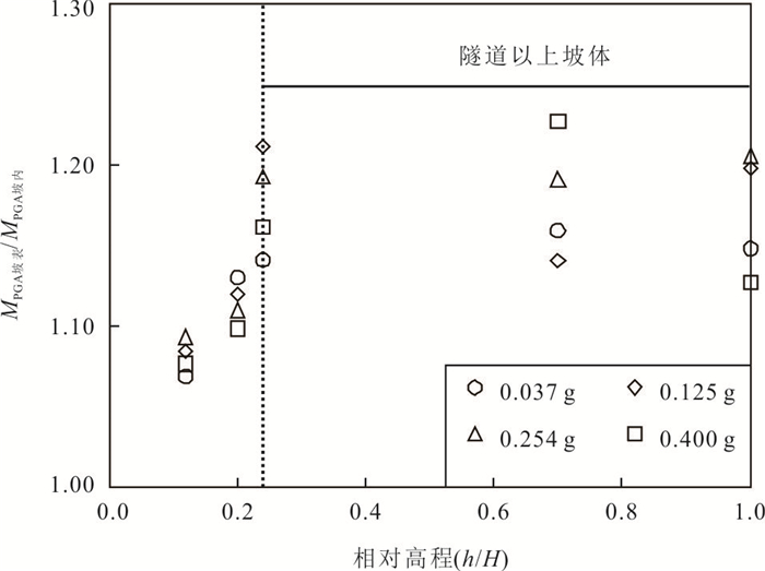
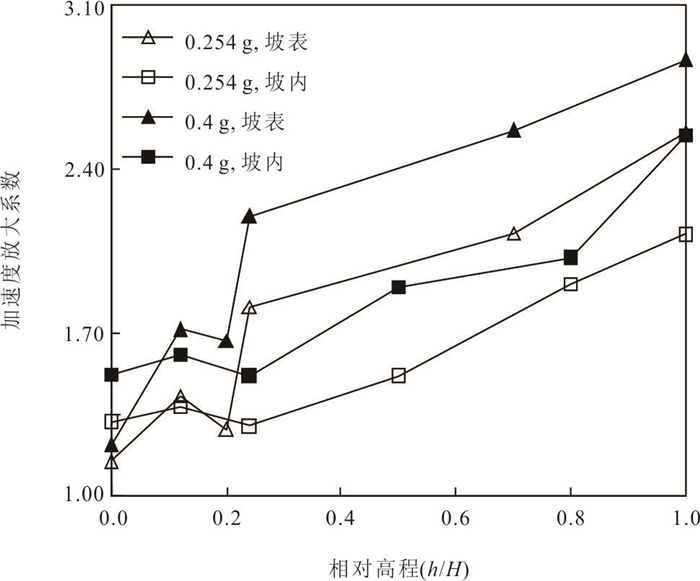
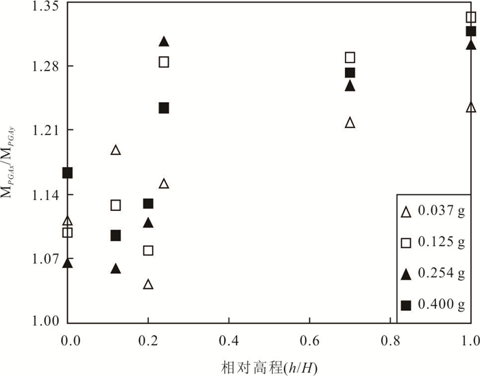
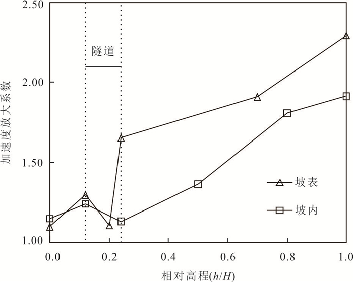
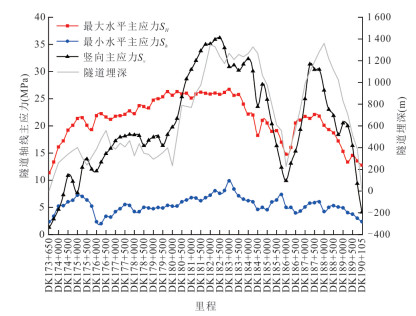
To study the dynamic response characteristics and dynamic failure modes of the bedding slope at the tunnel entrance under earthquakes, a shaking table scaled model test of the bedding slope at the tunnel entrance was designed based on the similarity relationship of the dynamic model tests. The experimental results show that the model slope has typical topographic amplification effect under seismic action. The model slope has obvious dynamic amplification effect of slope surface, and the dynamic amplification effect on the slope surface is larger than that in the slope under the same conditions. The input direction and strength of ground motion have influence on the dynamic response characteristics of the model slope. Compared with the input of vertical ground motion, the dynamic amplification effect of the model slope is larger when the input of horizontal ground motion under the same conditions. The tunnel structure changes the local dynamic response characteristics of the model slope and has a magnifying effect on the dynamic amplification effect of the slope. The dynamic failure mode of the model slope under earthquake action is as follows: earthquake induced-slip zone gradually formed on the topmost structural plane-slip failure above the topmost structural plane-slip body accumulation at the foot of slope.
To study the dynamic response characteristics and dynamic failure modes of the bedding slope at the tunnel entrance under earthquakes, a shaking table scaled model test of the bedding slope at the tunnel entrance was designed based on the similarity relationship of the dynamic model tests. The experimental results show that the model slope has typical topographic amplification effect under seismic action. The model slope has obvious dynamic amplification effect of slope surface, and the dynamic amplification effect on the slope surface is larger than that in the slope under the same conditions. The input direction and strength of ground motion have influence on the dynamic response characteristics of the model slope. Compared with the input of vertical ground motion, the dynamic amplification effect of the model slope is larger when the input of horizontal ground motion under the same conditions. The tunnel structure changes the local dynamic response characteristics of the model slope and has a magnifying effect on the dynamic amplification effect of the slope. The dynamic failure mode of the model slope under earthquake action is as follows: earthquake induced-slip zone gradually formed on the topmost structural plane-slip failure above the topmost structural plane-slip body accumulation at the foot of slope.


2022, 47(6): 2081-2093.
doi: 10.3799/dqkx.2021.153
Abstract:
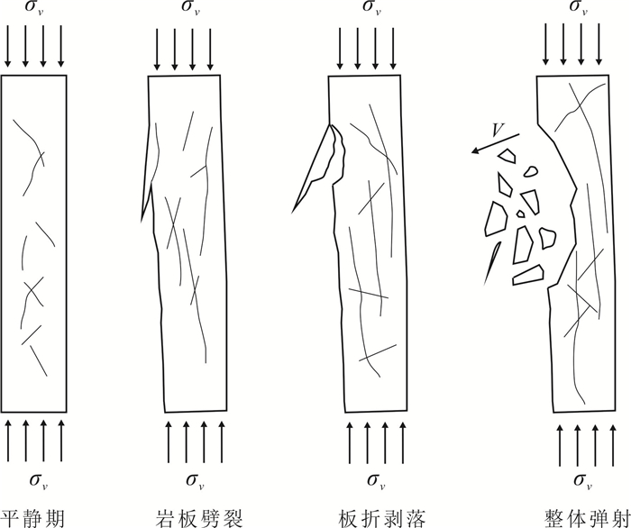
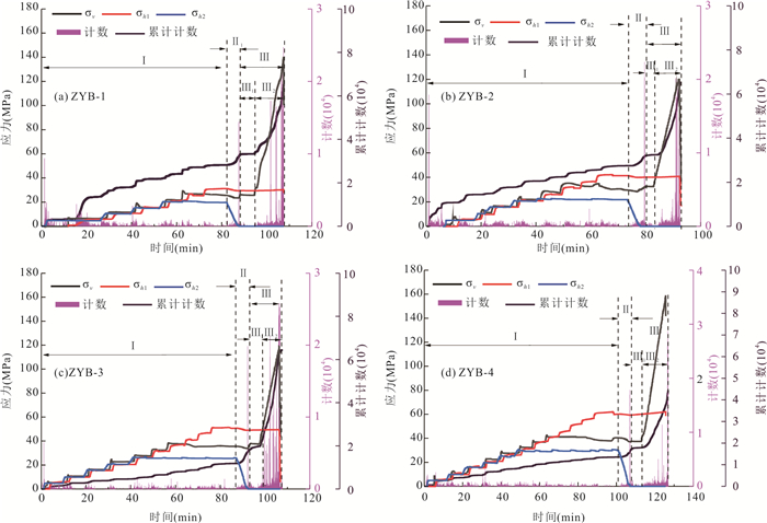
The deep-buried tunnel planned in Zheduo Mountain, Kangding County, Sichuan Province, is likely to rockburst due to its large buried depth and concentrated tectonic stress. In order to figure out the rockburst failure mechanism under different depths, in this study, the triaxial rockburst physical experiments of the granite in the Zheduo Mountain tunnel at different depths were carried out employing the stress monitoring system, high-speed camera system, and acoustic emission monitoring system. The phase characteristics, time characteristics, failure modes, and crack evolution of the granite in the Zheduo Mountain tunnel at different depths were studied with regard to the sound, light, and force and the experimental results show that the rockburst of Zheduo Mountain granite has obvious characteristics of time delaying rockburst (TDR). 770 m is the critical depth of the granite triaxial strength with one free face, and the lag characteristics of the excavation rockburst around this depth is obviously weakened. Rockburst at different depths can be divided into different stages: quiet period, splitting into plate stage, plate folding and spalling stage, and overall ejection stage. Rockburst acoustic emission characteristics reveal that the rockburst of Zheduo Mountain granite is mainly tensile failure, and with the increase of the depth, the number of tension cracks gradually increases and the number of shear cracks gradually decreases. According to the ratio of the stress difference and the uniaxial compressive strength at the time of the rockburst, the rockburst of Zheduo Mountain granite is divided into three failure modes: small particle ejection failure, rock slab splitting failure and mixed ejection failure, and the greater the stress ratio (σv-σh1)/σc is, the greater the rockburst intensity is.
The deep-buried tunnel planned in Zheduo Mountain, Kangding County, Sichuan Province, is likely to rockburst due to its large buried depth and concentrated tectonic stress. In order to figure out the rockburst failure mechanism under different depths, in this study, the triaxial rockburst physical experiments of the granite in the Zheduo Mountain tunnel at different depths were carried out employing the stress monitoring system, high-speed camera system, and acoustic emission monitoring system. The phase characteristics, time characteristics, failure modes, and crack evolution of the granite in the Zheduo Mountain tunnel at different depths were studied with regard to the sound, light, and force and the experimental results show that the rockburst of Zheduo Mountain granite has obvious characteristics of time delaying rockburst (TDR). 770 m is the critical depth of the granite triaxial strength with one free face, and the lag characteristics of the excavation rockburst around this depth is obviously weakened. Rockburst at different depths can be divided into different stages: quiet period, splitting into plate stage, plate folding and spalling stage, and overall ejection stage. Rockburst acoustic emission characteristics reveal that the rockburst of Zheduo Mountain granite is mainly tensile failure, and with the increase of the depth, the number of tension cracks gradually increases and the number of shear cracks gradually decreases. According to the ratio of the stress difference and the uniaxial compressive strength at the time of the rockburst, the rockburst of Zheduo Mountain granite is divided into three failure modes: small particle ejection failure, rock slab splitting failure and mixed ejection failure, and the greater the stress ratio (σv-σh1)/σc is, the greater the rockburst intensity is.


2022, 47(6): 2130-2148.
doi: 10.3799/dqkx.2021.170
Abstract:
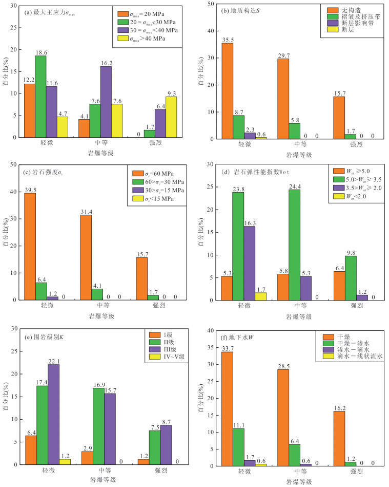
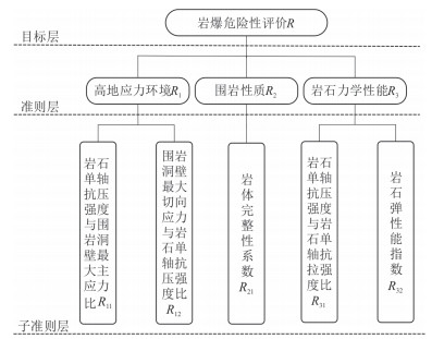
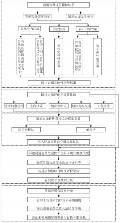
Aming at the uncertain factors in the rockburst risk assessment of deep lying tunnels in complex mountainous areas, the unascertained measurement theory was used to establish a tunnel rockburst risk evaluation model. By summarizing and analyzing the rockburst failure characteristics and key influencing factors of deep lying tunnels under typical high geostress conditions, 5 evaluation indexes were determined from three levels that objectively reflect the high geostress environment, rock mechanical properties and surrounding rock properties. In order to fully consider the subjective and objective factors of rockburst risk assessment, by introducing a distance function, using the combination of entropy weight method and analytic hierarchy process to construct a combination weighting method, and comprehensively determined the weight coefficient of each index. Based on the unascertained measurement theory and calculation rules, it constructed a linear single-index measurement function according to the rockburst risk classification standard. By calculating the single-index measurement evaluation matrix and the multi-index measurement vector, the rockburst risk assessment was carried out according to the confidence criterion. The unascertained measurement model of rockburst risk assessment was applied to the Sangzhuling tunnel of the Sichuan-Tibet traffic corridor. The evaluation accuracy was compared with that obtained from single index criteria such as strength-stress ratio method, Russenes criterion, rock brittleness coefficient, rock mass integrity coefficient, rock elastic energy index and the actual rockburst results. The research results show that the accuracy rate of the evaluation result of the model is 94.4%, which is 16.7%-66.7% higher than that of the single-index rockburst criterion.
Aming at the uncertain factors in the rockburst risk assessment of deep lying tunnels in complex mountainous areas, the unascertained measurement theory was used to establish a tunnel rockburst risk evaluation model. By summarizing and analyzing the rockburst failure characteristics and key influencing factors of deep lying tunnels under typical high geostress conditions, 5 evaluation indexes were determined from three levels that objectively reflect the high geostress environment, rock mechanical properties and surrounding rock properties. In order to fully consider the subjective and objective factors of rockburst risk assessment, by introducing a distance function, using the combination of entropy weight method and analytic hierarchy process to construct a combination weighting method, and comprehensively determined the weight coefficient of each index. Based on the unascertained measurement theory and calculation rules, it constructed a linear single-index measurement function according to the rockburst risk classification standard. By calculating the single-index measurement evaluation matrix and the multi-index measurement vector, the rockburst risk assessment was carried out according to the confidence criterion. The unascertained measurement model of rockburst risk assessment was applied to the Sangzhuling tunnel of the Sichuan-Tibet traffic corridor. The evaluation accuracy was compared with that obtained from single index criteria such as strength-stress ratio method, Russenes criterion, rock brittleness coefficient, rock mass integrity coefficient, rock elastic energy index and the actual rockburst results. The research results show that the accuracy rate of the evaluation result of the model is 94.4%, which is 16.7%-66.7% higher than that of the single-index rockburst criterion.


2022, 47(6): 2149-2164.
doi: 10.3799/dqkx.2021.143
Abstract:
On 17 June, 2019, an M 6.0 earthquake occurred in Changning County, Sichuan Province, with high aftershock activity frequency and intensity. And among the aftershocks, there are 4 strong ones with M≥5.0, which is different from the previous M 6.0 earthquakes. The aftershock activity is closely related to the regional stress change after the mainshock. In order to study the relationship between them, a 3D viscoelastic finite element model of the lithosphere in the Changning area is established. In the model, the main active structures, topographic relief and deep inversion results were considered. By using numerical method, the present tectonic background stress field in the study area is reconstructed to conform to the GPS observed value and the measured one of maximum horizontal principal compressive stress direction. Then the Changning M 6.0 earthquake and its strong aftershock sequence with M≥5.0 were simulated sequentially. The relationship between the stress evolution and aftershocks, as well as the mainshock and the strong aftershock sequence with M≥5.0 were studied by calculating the Coulomb failure stress. The results show that the occurrence of the Changning M 6.0 earthquake may be independent with the regional tectonic loading factors, and the aftershock activity is obviously controlled by the regional stress change after the mainshock. After the Changning earthquake, the stress at the depth of 10 km in the Yutan-Changning anticline was fully released, and the Coulomb failure stress decreased significantly. However, at the depth of 3 km, the Coulomb failure stress increases obviously and the stress level is still high.
On 17 June, 2019, an M 6.0 earthquake occurred in Changning County, Sichuan Province, with high aftershock activity frequency and intensity. And among the aftershocks, there are 4 strong ones with M≥5.0, which is different from the previous M 6.0 earthquakes. The aftershock activity is closely related to the regional stress change after the mainshock. In order to study the relationship between them, a 3D viscoelastic finite element model of the lithosphere in the Changning area is established. In the model, the main active structures, topographic relief and deep inversion results were considered. By using numerical method, the present tectonic background stress field in the study area is reconstructed to conform to the GPS observed value and the measured one of maximum horizontal principal compressive stress direction. Then the Changning M 6.0 earthquake and its strong aftershock sequence with M≥5.0 were simulated sequentially. The relationship between the stress evolution and aftershocks, as well as the mainshock and the strong aftershock sequence with M≥5.0 were studied by calculating the Coulomb failure stress. The results show that the occurrence of the Changning M 6.0 earthquake may be independent with the regional tectonic loading factors, and the aftershock activity is obviously controlled by the regional stress change after the mainshock. After the Changning earthquake, the stress at the depth of 10 km in the Yutan-Changning anticline was fully released, and the Coulomb failure stress decreased significantly. However, at the depth of 3 km, the Coulomb failure stress increases obviously and the stress level is still high.


2022, 47(6): 2165-2174.
doi: 10.3799/dqkx.2021.103
Abstract:
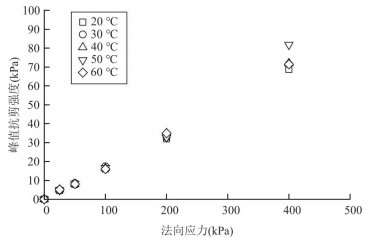
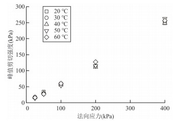
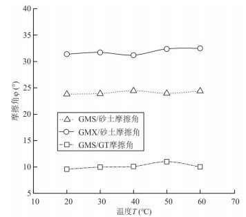
HDPE geomembrane (GM) may be in high temperature condition in environmental protection projects such as urban sanitary landfill. Most of the existing experimental studies on the mechanical properties of GM were carried out at normal temperature, the temperature effect of the mechanical properties of GM relates to in-site slope stability and engineering safety. The temperature-controlled tensile tests of GM, interface shear tests of GM/sand interface and GM / non-woven geotextile (GT) interface under different temperature conditions were carried out to reveal the influence of temperature on the geo-mechanical properties of GM. Qualitative and quantitative effects of temperature on the geo-mechanical properties are revealed through comparative analysis of the tensile properties of GM and the shear properties of GM interface under different temperature conditions. The test results show that the tensile strength of GM changes significantly with temperature, and the tensile strength obtained at high temperature (above 70 ℃) can be reduced by nearly 80% compared with the normal temperature situation. The effect of temperature on the shear properties of GM/GT interface is obviously greater than that of GM/sand interface, and the temperature effect of GM geo-mechanical properties deserve more attention of engineers.
HDPE geomembrane (GM) may be in high temperature condition in environmental protection projects such as urban sanitary landfill. Most of the existing experimental studies on the mechanical properties of GM were carried out at normal temperature, the temperature effect of the mechanical properties of GM relates to in-site slope stability and engineering safety. The temperature-controlled tensile tests of GM, interface shear tests of GM/sand interface and GM / non-woven geotextile (GT) interface under different temperature conditions were carried out to reveal the influence of temperature on the geo-mechanical properties of GM. Qualitative and quantitative effects of temperature on the geo-mechanical properties are revealed through comparative analysis of the tensile properties of GM and the shear properties of GM interface under different temperature conditions. The test results show that the tensile strength of GM changes significantly with temperature, and the tensile strength obtained at high temperature (above 70 ℃) can be reduced by nearly 80% compared with the normal temperature situation. The effect of temperature on the shear properties of GM/GT interface is obviously greater than that of GM/sand interface, and the temperature effect of GM geo-mechanical properties deserve more attention of engineers.


2022, 47(6): 2175-2189.
doi: 10.3799/dqkx.2021.234
Abstract:
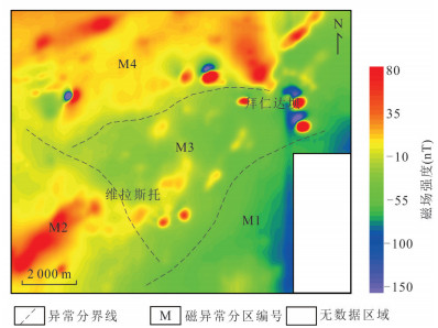
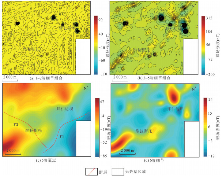
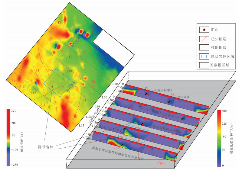
Weilasituo area is located in the metallogenic belt of the Great Xing'an Range (SGXR). With abundant structures and favorable mineralization conditions, there is great potential for continued prospecting. In this paper, aeromagnetic data of Weilasituo area were processed by means of upward continuation, wavelet analysis and boundary recognition techniques. Combined with the existing geological data, the geological structure of Weilasituo area is further improved, and the formation process of Weilasituo and Bairendaba deposit is sorted out. The information of concealed pluton in the north of Weilasituo is extracted from aeromagnetic anomaly apparent magnetic susceptibility imaging inversion results. The results show follows : (1) The NE-to-left shear fracture zone in the central Weilasituo region controls the magmatic activity and ore body migration in the region as a whole. At the same time, the fault zone is also the magnetic transition zone between the negative magnetic anomaly area in the southeast and the positive magnetic anomaly area in the northwest. So the known ore points are closely related to the structure distribution and magnetic strength distribution in the study area. Magnetic anomaly inversion results show that there may be larger hidden ore body deep underground in the north of Weilasituo. Accordingly, in this paper it divides three metallogenic prospect areas, providing certain reference for subsequent prospecting work. (2) The results of upward continuation and wavelet analysis show that Baiyinchagan-Daqingmuchang fault (F1) and Zhulikehe fault (F2) formed early and extended deep underground. It is the main fault controlling magmatic activity and tectonic development in the Weilasituo area. Combined with the results of boundary identification such as tilt angle method, the distribution of fracture and magnetic rock mass in the study area has been elaborated. Fourteen faults and eleven magnetic rocks are identified in the fracture zone. According to its formation and distribution, it is found that Weilasituo is the metallogenic center of the study area. The ore-forming fluids from deep earth rise and enrich near Weilasituo through faults F1 and F2. Then, from west to east, it migrates along the NE fault fracture zone (F3, F4, F5, F6, F7, F10, etc) to Bairendaba. Finally, two typical polymetallic deposits in the Great Xing'an Range (SGXR) area gradually formed.
Weilasituo area is located in the metallogenic belt of the Great Xing'an Range (SGXR). With abundant structures and favorable mineralization conditions, there is great potential for continued prospecting. In this paper, aeromagnetic data of Weilasituo area were processed by means of upward continuation, wavelet analysis and boundary recognition techniques. Combined with the existing geological data, the geological structure of Weilasituo area is further improved, and the formation process of Weilasituo and Bairendaba deposit is sorted out. The information of concealed pluton in the north of Weilasituo is extracted from aeromagnetic anomaly apparent magnetic susceptibility imaging inversion results. The results show follows : (1) The NE-to-left shear fracture zone in the central Weilasituo region controls the magmatic activity and ore body migration in the region as a whole. At the same time, the fault zone is also the magnetic transition zone between the negative magnetic anomaly area in the southeast and the positive magnetic anomaly area in the northwest. So the known ore points are closely related to the structure distribution and magnetic strength distribution in the study area. Magnetic anomaly inversion results show that there may be larger hidden ore body deep underground in the north of Weilasituo. Accordingly, in this paper it divides three metallogenic prospect areas, providing certain reference for subsequent prospecting work. (2) The results of upward continuation and wavelet analysis show that Baiyinchagan-Daqingmuchang fault (F1) and Zhulikehe fault (F2) formed early and extended deep underground. It is the main fault controlling magmatic activity and tectonic development in the Weilasituo area. Combined with the results of boundary identification such as tilt angle method, the distribution of fracture and magnetic rock mass in the study area has been elaborated. Fourteen faults and eleven magnetic rocks are identified in the fracture zone. According to its formation and distribution, it is found that Weilasituo is the metallogenic center of the study area. The ore-forming fluids from deep earth rise and enrich near Weilasituo through faults F1 and F2. Then, from west to east, it migrates along the NE fault fracture zone (F3, F4, F5, F6, F7, F10, etc) to Bairendaba. Finally, two typical polymetallic deposits in the Great Xing'an Range (SGXR) area gradually formed.


2022, 47(6): 2190-2198.
doi: 10.3799/dqkx.2021.186
Abstract:
Fatigue is one of the important mechanical properties of rocks, which is closely related to the safety and stability of engineering. Under the action of circulating loads, the initial damage of the rock continues to accumulate and intensify, eventually leading to the instability and destruction of the rock, thus inducing engineering catastrophes. In this paper, it describes the research progress of rock fatigue damage and failure based on acoustic emission and infrared radiation technology in recent years. Firstly, it discusses the research progress of rock fatigue damage characteristics carried out by researchers using acoustic emission time-domain parameters, acoustic emission spatial evolution, and Felicity ratio. Then, it discusses the research progress of researchers using acoustic emission time-domain parameters, damage variables, fractal dimension values, Felicity ratio, loading/unloading response ratio, RA and b-value parameters to carry out the research progress of rock fatigue failure precursors. On this basis, it also discusses the research progress of researchers using infrared radiation technology to develop rock fatigue damage and failure precursors.Finally, several issues that need to be further resolved in the future research on rock fatigue damage and failure precursors are put forward. This article can play a positive role in promoting the in-depth understanding of rock fatigue damage mechanism and failure precursor characteristics.
Fatigue is one of the important mechanical properties of rocks, which is closely related to the safety and stability of engineering. Under the action of circulating loads, the initial damage of the rock continues to accumulate and intensify, eventually leading to the instability and destruction of the rock, thus inducing engineering catastrophes. In this paper, it describes the research progress of rock fatigue damage and failure based on acoustic emission and infrared radiation technology in recent years. Firstly, it discusses the research progress of rock fatigue damage characteristics carried out by researchers using acoustic emission time-domain parameters, acoustic emission spatial evolution, and Felicity ratio. Then, it discusses the research progress of researchers using acoustic emission time-domain parameters, damage variables, fractal dimension values, Felicity ratio, loading/unloading response ratio, RA and b-value parameters to carry out the research progress of rock fatigue failure precursors. On this basis, it also discusses the research progress of researchers using infrared radiation technology to develop rock fatigue damage and failure precursors.Finally, several issues that need to be further resolved in the future research on rock fatigue damage and failure precursors are put forward. This article can play a positive role in promoting the in-depth understanding of rock fatigue damage mechanism and failure precursor characteristics.
2022, 47(6): 2199-2218.
doi: 10.3799/dqkx.2021.230
Abstract:
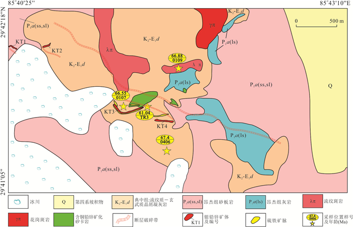
Dajiacuo silver polymetallic deposit is the firstly and newly discovered deposit dominated by silver in the western Gangdese metallogenic belt. In order to find out the time of diagenesis and mineralization, genesis of ore-bearing rocks and metallogenic significance of the deposit, zircon U-Pb chronology, trace elements and Hf isotopes, whole rock geochemistry and molybdenite Re-Os chronology of the ore-bearing (sub-volcanic) volcanic rocks (rhyolitic crystal tuff and rhyolitic porphyry) exposed in the mine area are analyzed in this paper. The results show that the ore-bearing (sub-volcanic) volcanic rocks were formed at 66.6-67.4 Ma, and the late molybdenite isotopic Re-Os model age was 61.0±0.8 Ma. Combined with the mineralization characteristics of ore-bearing geological bodies and the interpenetration relationship between quartz-pyrite and molybdenite veins and ore-bearing rhyolite porphyry etc., it is confirmed that Dajiacuo has two stages of mineralization dominated by the high silicified (sub-volcanic) volcanic rock type and skarn type silver-polymetallic mineralization in the early stage and the quartz vein-type silver-polymetallic mineralization in the late stage. It has a metallogenic time limited of 66.6-61.0 Ma, forming the epithermal cryogenic metallogenic system related to the post-volcanic hydrothermal period. The geochemical data of the (sub-volcanic) volcanic rocks indicate that they belong to the high-K series to shoshonite series with metaluminous to peraluminous, enriched in LREE and large ion lithophile elements (K, Rb, Pb), and depleted in HREE and high field strength elements (Nb, Ta, Ti). The average temperature of zircon is 712 ℃, the εHf(t) values are strongly negative (-16.5 to -3.6) and the TDMC is 1.2-2.1 Ga. The geochemical characteristics indicate that the ore-bearing rocks were typical S-type granite, which were generated from the partial melting of the Paleo-Mesoproterozoic Lhasa crystallization basement. Their characteristics are consistent with those of the ore-forming magmatic rock associated with the Ag-Pb-Zn deposits in the central Lhasa subterrane, but are obvious different with erupted Ⅰ-type granite related copper polymetallic mineralization in the south Lhasa subterrane. It is revealed that the south Lhasa subterrane has the same metallogenic potential as the central Lhasa subterrane related to S-type granites and has great theoretical and practical significance to enrich the mineralization types of the south Lhasa subterrane and promote the further exploration of this type deposits.
Dajiacuo silver polymetallic deposit is the firstly and newly discovered deposit dominated by silver in the western Gangdese metallogenic belt. In order to find out the time of diagenesis and mineralization, genesis of ore-bearing rocks and metallogenic significance of the deposit, zircon U-Pb chronology, trace elements and Hf isotopes, whole rock geochemistry and molybdenite Re-Os chronology of the ore-bearing (sub-volcanic) volcanic rocks (rhyolitic crystal tuff and rhyolitic porphyry) exposed in the mine area are analyzed in this paper. The results show that the ore-bearing (sub-volcanic) volcanic rocks were formed at 66.6-67.4 Ma, and the late molybdenite isotopic Re-Os model age was 61.0±0.8 Ma. Combined with the mineralization characteristics of ore-bearing geological bodies and the interpenetration relationship between quartz-pyrite and molybdenite veins and ore-bearing rhyolite porphyry etc., it is confirmed that Dajiacuo has two stages of mineralization dominated by the high silicified (sub-volcanic) volcanic rock type and skarn type silver-polymetallic mineralization in the early stage and the quartz vein-type silver-polymetallic mineralization in the late stage. It has a metallogenic time limited of 66.6-61.0 Ma, forming the epithermal cryogenic metallogenic system related to the post-volcanic hydrothermal period. The geochemical data of the (sub-volcanic) volcanic rocks indicate that they belong to the high-K series to shoshonite series with metaluminous to peraluminous, enriched in LREE and large ion lithophile elements (K, Rb, Pb), and depleted in HREE and high field strength elements (Nb, Ta, Ti). The average temperature of zircon is 712 ℃, the εHf(t) values are strongly negative (-16.5 to -3.6) and the TDMC is 1.2-2.1 Ga. The geochemical characteristics indicate that the ore-bearing rocks were typical S-type granite, which were generated from the partial melting of the Paleo-Mesoproterozoic Lhasa crystallization basement. Their characteristics are consistent with those of the ore-forming magmatic rock associated with the Ag-Pb-Zn deposits in the central Lhasa subterrane, but are obvious different with erupted Ⅰ-type granite related copper polymetallic mineralization in the south Lhasa subterrane. It is revealed that the south Lhasa subterrane has the same metallogenic potential as the central Lhasa subterrane related to S-type granites and has great theoretical and practical significance to enrich the mineralization types of the south Lhasa subterrane and promote the further exploration of this type deposits.


2022, 47(6): 2219-2244.
doi: 10.3799/dqkx.2021.229
Abstract:
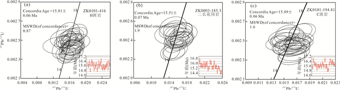
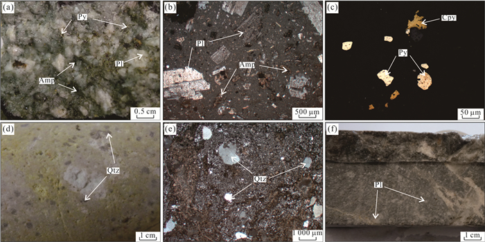
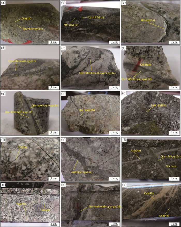
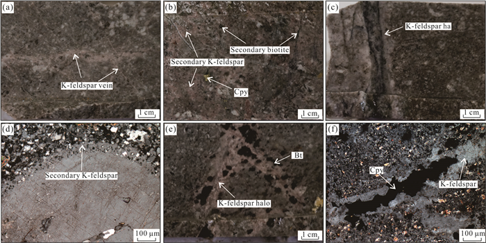
The Cimabanshuo is a newly discovered porphyry copper deposit in the western part of the Gangdese belt in Tibet. It is located about 10 km southwest of the super-large Zhunuo porphyry copper deposit, which is surrounded by the Beimulang, Luobugangmu, and Dongshibu deposits. These deposits are an important part of the Zhunuo copper ore-concentrated district. To further clarify the prospecting potential and exploration direction of the Cimarbanshuo, a systematic zircon U-Pb geochronology analysis and zircon trace element analysis, elaborate alteration-mineralization cataloging of the drilling, and detailed petrographic observations were carried out for the deposit. The study shows that the Miocene intrusions of the main ore-forming period of the Cimabanshuo copper deposit were a composite pluton, consisting of fine-grained monzonite granite porphyry (F porphyry: 16±0.30 Ma), coarse-grained monzonite porphyry (C porphyry: 15.89±0.06 Ma), hornblende monzonite granite porphyry (H porphyry: 15.81±0.06 Ma), diorite porphyry, and monzonitic granite (15.51±0.07 Ma). Different magmas contribute variously to mineralization. The ratios of zircon Ce4+/Ce3+ (average 190) and 10 000×(Eu/Eu*)/Y (average 13) indicate that the oxygen fugacity and water content of the Miocene rocks in the Cimabanshuo are higher than those in the Zhunuo deposit. The hydrothermal evolution of the Cimabanshuo can be divided into 4 stages and 14 types of veins. According to the correspondence between alteration and mineralization at Cimabanshuo, it concludes that copper mainly precipitates in the K-silicate alteration stage, especially closely related to biotite alteration. Propylitic alteration also contributes to part of the copper and phyllic alteration stage contains the least amount of Cu. Compared with the classic alteration-mineralization zoning model of porphyry copper systems, the Cimabanshuo exhibits some abnormal characteristics, such as a strong superposition of deep K-silicate alteration by propylitic alteration and the low-temperature alteration was cutting by high-temperature veins, indicating that there are multiple stages of magma-hydrothermal processes, which provide a steady stream of thermodynamics, ore-forming materials, and ore-forming fluids for mineralization. The F porphyry is the main mineralizing intrusion, which is distributed in the northern part of the Cimabanshuo deposit.The alteration-mineralization in the north of the mining area is stronger than that in the south, and the deep development of strong propylitization alteration. In conclusion, it believes that the Cimabanshuo deposit also has great prospecting potential. The next step of the exploration should be the deeper levels and northeast direction of the mining area, focusing on the F porphyry, C porphyry, and the zones of K-silicate alteration.
The Cimabanshuo is a newly discovered porphyry copper deposit in the western part of the Gangdese belt in Tibet. It is located about 10 km southwest of the super-large Zhunuo porphyry copper deposit, which is surrounded by the Beimulang, Luobugangmu, and Dongshibu deposits. These deposits are an important part of the Zhunuo copper ore-concentrated district. To further clarify the prospecting potential and exploration direction of the Cimarbanshuo, a systematic zircon U-Pb geochronology analysis and zircon trace element analysis, elaborate alteration-mineralization cataloging of the drilling, and detailed petrographic observations were carried out for the deposit. The study shows that the Miocene intrusions of the main ore-forming period of the Cimabanshuo copper deposit were a composite pluton, consisting of fine-grained monzonite granite porphyry (F porphyry: 16±0.30 Ma), coarse-grained monzonite porphyry (C porphyry: 15.89±0.06 Ma), hornblende monzonite granite porphyry (H porphyry: 15.81±0.06 Ma), diorite porphyry, and monzonitic granite (15.51±0.07 Ma). Different magmas contribute variously to mineralization. The ratios of zircon Ce4+/Ce3+ (average 190) and 10 000×(Eu/Eu*)/Y (average 13) indicate that the oxygen fugacity and water content of the Miocene rocks in the Cimabanshuo are higher than those in the Zhunuo deposit. The hydrothermal evolution of the Cimabanshuo can be divided into 4 stages and 14 types of veins. According to the correspondence between alteration and mineralization at Cimabanshuo, it concludes that copper mainly precipitates in the K-silicate alteration stage, especially closely related to biotite alteration. Propylitic alteration also contributes to part of the copper and phyllic alteration stage contains the least amount of Cu. Compared with the classic alteration-mineralization zoning model of porphyry copper systems, the Cimabanshuo exhibits some abnormal characteristics, such as a strong superposition of deep K-silicate alteration by propylitic alteration and the low-temperature alteration was cutting by high-temperature veins, indicating that there are multiple stages of magma-hydrothermal processes, which provide a steady stream of thermodynamics, ore-forming materials, and ore-forming fluids for mineralization. The F porphyry is the main mineralizing intrusion, which is distributed in the northern part of the Cimabanshuo deposit.The alteration-mineralization in the north of the mining area is stronger than that in the south, and the deep development of strong propylitization alteration. In conclusion, it believes that the Cimabanshuo deposit also has great prospecting potential. The next step of the exploration should be the deeper levels and northeast direction of the mining area, focusing on the F porphyry, C porphyry, and the zones of K-silicate alteration.


2022, 47(6): 2245-2263.
doi: 10.3799/dqkx.2021.077
Abstract:
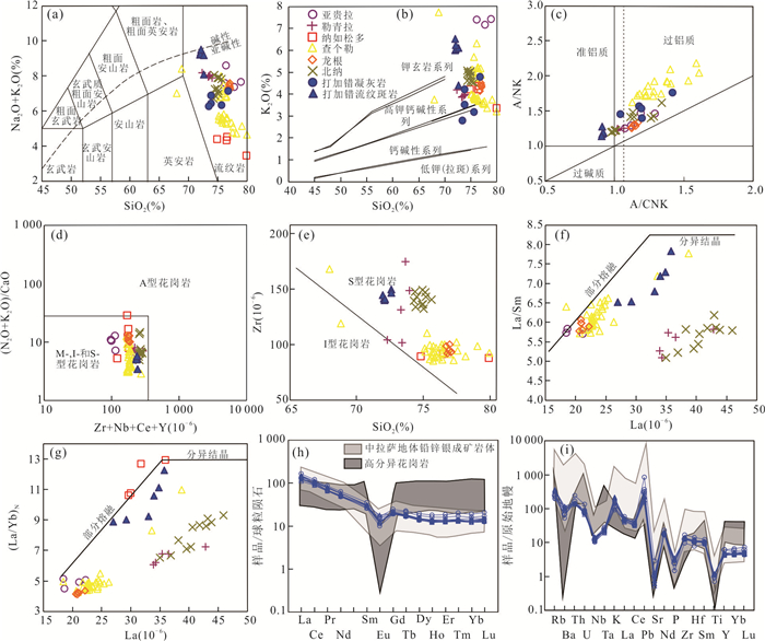
Study of A-type granites is critical for understanding the crust-mantle interaction and tectonic evolution in the Tianshan orogenic belt. Here it reports a detailed petrologic, geochemical and geochronologic data for the alkali-feldspar granite and syenogranite from Harlik in East Tianshan, to constrain their petrogenesis and tectonic setting. LA–ICP–MS zircon U–Pb ages indicate that the granites were emplaced at early Early Carboniferous (350.7±2.0 Ma and 351.8±2.0 Ma). The rocks contain abundant alkali feldspar and biotite with little sodium amphibole. The granites are characterized by high silicon and alkali, low CaO and MgO contents, and enriched in Rb, Th, K (LILE), and Zr, Hf (HFSE), but depleted in Ba, Sr, and Eu. The chondrite-normalized REE patterns show slight enrichment in LREE with (La/Yb)N from 3.23 to 5.55, and great negative Eu anomalies (δEu=0.19-0.28). These feactures indicate the geochemical characteristics of high-K meta- to per-aluminous A-type granite. They have positive εNd(t) (+4.2 to +4.8) values, and the Neoproterozoic two stage Nd model ages (tDM2=0.71-0.75 Ga), suggesting that the A-type granitic magma was probably generated from partial melting of a juvenile crustal source produced by depleted mantle-derived basaltic magmas and a few marine sediments. Combining with the previous works in this region, our study reveals that Harlik and Bogda are constrained by the same tectonic setting in Early Carboniferous, and the A-type granites from Harlik were genetically linked to the initial extensional stage of the Bogda back-arc rift.
Study of A-type granites is critical for understanding the crust-mantle interaction and tectonic evolution in the Tianshan orogenic belt. Here it reports a detailed petrologic, geochemical and geochronologic data for the alkali-feldspar granite and syenogranite from Harlik in East Tianshan, to constrain their petrogenesis and tectonic setting. LA–ICP–MS zircon U–Pb ages indicate that the granites were emplaced at early Early Carboniferous (350.7±2.0 Ma and 351.8±2.0 Ma). The rocks contain abundant alkali feldspar and biotite with little sodium amphibole. The granites are characterized by high silicon and alkali, low CaO and MgO contents, and enriched in Rb, Th, K (LILE), and Zr, Hf (HFSE), but depleted in Ba, Sr, and Eu. The chondrite-normalized REE patterns show slight enrichment in LREE with (La/Yb)N from 3.23 to 5.55, and great negative Eu anomalies (δEu=0.19-0.28). These feactures indicate the geochemical characteristics of high-K meta- to per-aluminous A-type granite. They have positive εNd(t) (+4.2 to +4.8) values, and the Neoproterozoic two stage Nd model ages (tDM2=0.71-0.75 Ga), suggesting that the A-type granitic magma was probably generated from partial melting of a juvenile crustal source produced by depleted mantle-derived basaltic magmas and a few marine sediments. Combining with the previous works in this region, our study reveals that Harlik and Bogda are constrained by the same tectonic setting in Early Carboniferous, and the A-type granites from Harlik were genetically linked to the initial extensional stage of the Bogda back-arc rift.


2022, 47(6): 2264-2274.
doi: 10.3799/dqkx.2021.262
Abstract:
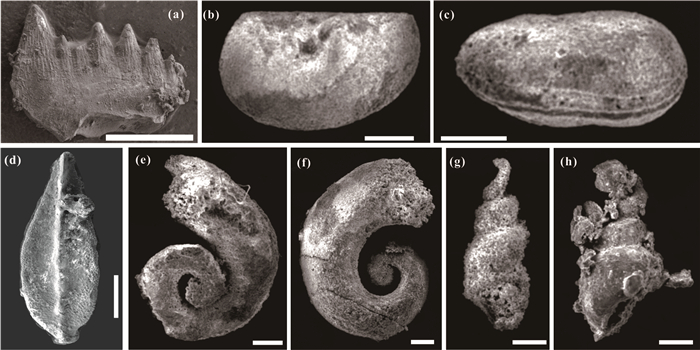
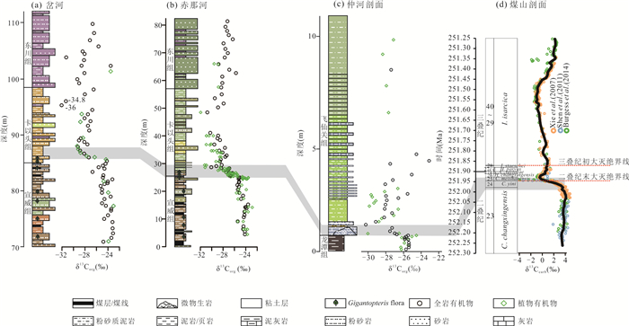
The correlation between the marine and terrestrial Permian-Triassic (P-Tr) strata has a great significance for the definition of the terrestrial P-Tr boundary and the comprehensive understanding for the nature of this global biotic and environmental event. In the present study, it investigated the fossils and organic carbon isotopes of the P-Tr boundary section of Zhonghe in Liupanshui City, Guizhou Province. A preliminary framework for the correlation of marine and terrestrial biostratigraphy and organic carbon isotope stratigraphy was established by combining the previous studies in this area. Moreover, the organic carbon isotopes of plants and marine inorganic carbon isotopes share the same trends, which are confirmed by the evidence of the biostratigraphic correlation framework. Accordingly, it concludes that high-resolution chemostratigraphy of organic carbon isotope is one of the effective proxies to achieve marine and terrestrial stratigraphic correlation.
The correlation between the marine and terrestrial Permian-Triassic (P-Tr) strata has a great significance for the definition of the terrestrial P-Tr boundary and the comprehensive understanding for the nature of this global biotic and environmental event. In the present study, it investigated the fossils and organic carbon isotopes of the P-Tr boundary section of Zhonghe in Liupanshui City, Guizhou Province. A preliminary framework for the correlation of marine and terrestrial biostratigraphy and organic carbon isotope stratigraphy was established by combining the previous studies in this area. Moreover, the organic carbon isotopes of plants and marine inorganic carbon isotopes share the same trends, which are confirmed by the evidence of the biostratigraphic correlation framework. Accordingly, it concludes that high-resolution chemostratigraphy of organic carbon isotope is one of the effective proxies to achieve marine and terrestrial stratigraphic correlation.


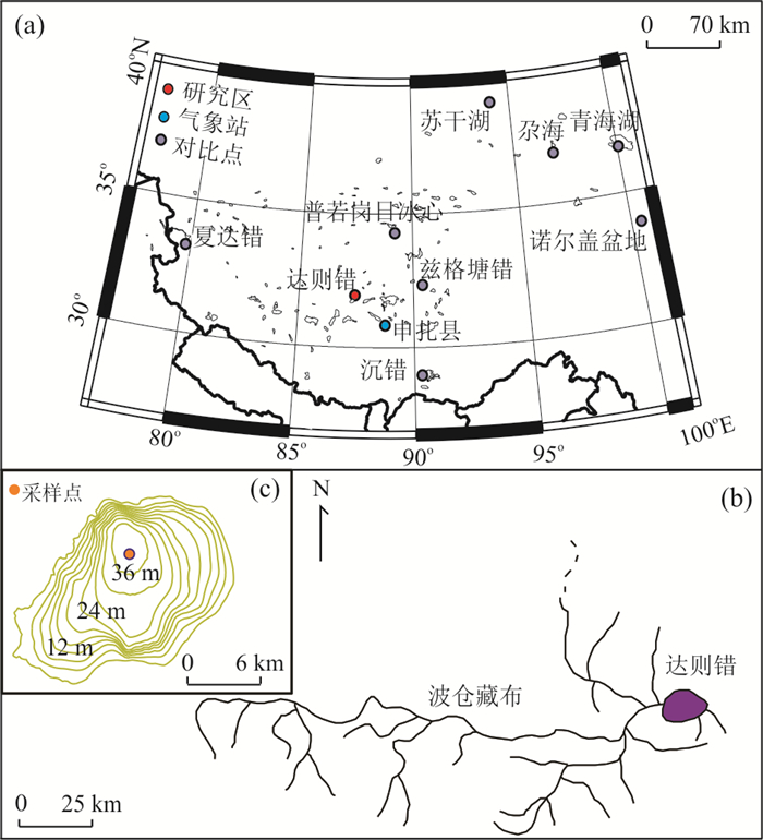
2022, 47(6): 2275-2286.
doi: 10.3799/dqkx.2021.167
Abstract:
Based on the analyses of δ13C and C/N ratio of organic matter in Dagze Co sediments, combined with the records of plankton, nutrient salts, temperature and precipitation, the climatic and environmental implications of organic matter δ13C in Dagze Co sediments during the past 1 000 years were discussed. The results indicate that organic matter of Dagze Co sediment was mainly composed of the autogenous aquatic bioclasts from the lake. Prior to the significant impact of human activities during the past thousand years, climate change was the main factor affecting the formation of δ13C in the Dagze Co sediments. The δ13C value of organic matter was significantly heavier during the cold and dry periods of 1050-1200 AD and 1450-1650 AD, and was considerably lighter during the warmer and wetter periods of 950-1050 AD, 1200-1450 AD and 1650-1850 AD. However, in the past 150 years, the δ13C of organic matter in lake sediments was dramatically heavier, which was mainly affected by changes in the concentration of nutrients caused by human activities. This study also shows that the application of C/N value to determine the source of organic matter in Dagze Co, which is semi-convective and with a single nutrient structure, is not reliable, and it is necessary to combine field factors.
Based on the analyses of δ13C and C/N ratio of organic matter in Dagze Co sediments, combined with the records of plankton, nutrient salts, temperature and precipitation, the climatic and environmental implications of organic matter δ13C in Dagze Co sediments during the past 1 000 years were discussed. The results indicate that organic matter of Dagze Co sediment was mainly composed of the autogenous aquatic bioclasts from the lake. Prior to the significant impact of human activities during the past thousand years, climate change was the main factor affecting the formation of δ13C in the Dagze Co sediments. The δ13C value of organic matter was significantly heavier during the cold and dry periods of 1050-1200 AD and 1450-1650 AD, and was considerably lighter during the warmer and wetter periods of 950-1050 AD, 1200-1450 AD and 1650-1850 AD. However, in the past 150 years, the δ13C of organic matter in lake sediments was dramatically heavier, which was mainly affected by changes in the concentration of nutrients caused by human activities. This study also shows that the application of C/N value to determine the source of organic matter in Dagze Co, which is semi-convective and with a single nutrient structure, is not reliable, and it is necessary to combine field factors.