2022 Vol. 47, No. 8
Display Method:
 PDF 8918KB
2022, 47(8): 2667-2678.
doi: 10.3799/dqkx.2022.302
Abstract:
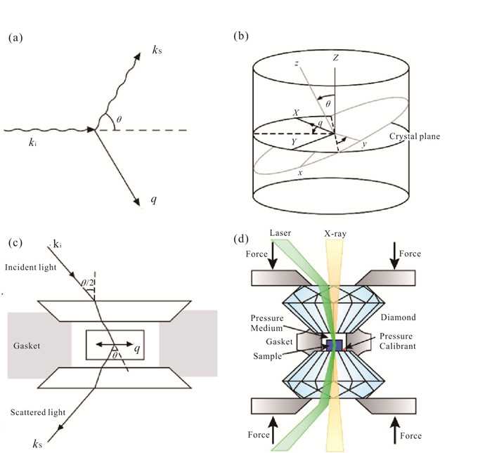
Experimental geoscience utilizes experimental devices and technologies to simulate the high‐temperature and high‐pressure conditions inside the Earth, and conduct research on the physical and chemical properties of the Earth's interior materials and the Earth's interior processes.In the past ten years, the rapid development of experimental geoscience in China has made China becomes an important international research force in the field of high‐temperature and high‐pressure experiments.This paper mainly introduces the definition and strategic value of experimental geoscience, briefly describes the status and weakness of experimental geoscience in China, puts forward ideas and important measures for the future development of the discipline, and looks forward to the priority development direction of the discipline in the future.
Experimental geoscience utilizes experimental devices and technologies to simulate the high‐temperature and high‐pressure conditions inside the Earth, and conduct research on the physical and chemical properties of the Earth's interior materials and the Earth's interior processes.In the past ten years, the rapid development of experimental geoscience in China has made China becomes an important international research force in the field of high‐temperature and high‐pressure experiments.This paper mainly introduces the definition and strategic value of experimental geoscience, briefly describes the status and weakness of experimental geoscience in China, puts forward ideas and important measures for the future development of the discipline, and looks forward to the priority development direction of the discipline in the future.
2022, 47(8): 2679-2690.
doi: 10.3799/dqkx.2022.240
Abstract:
Experimental geochemistry involves the simulation of the physical and chemical conditions of the Earth's interior. By this, the behavior, nature and effects of elements and isotopes are studied experimentally, so as to constrain processes such as petrogenesis and mineralization, magma evolution, fluid metasomatism, and differentiation. The field of experimental geochemistry emerged as a tool to offer forward modeling for challenging issues that are difficult to address by studies with traditional geochemistry and petrology. The rapid development of the field is attributed to the improvement of facilities for generating high‐pressure and high‐temperature conditions and the availability of modern analytical techniques. In the past about half century, the growing research in the field of experimental geochemistry has greatly promoted the development of traditional geochemistry and even the entire earth science related fields. In the next one or two decades, experimental geochemistry is expected to further strengthen important scientific achievements in the following aspects: (1) deep Earth and early Earth; (2) volatiles and habitability of the Earth; (3) experimental simulations and planetary science.
Experimental geochemistry involves the simulation of the physical and chemical conditions of the Earth's interior. By this, the behavior, nature and effects of elements and isotopes are studied experimentally, so as to constrain processes such as petrogenesis and mineralization, magma evolution, fluid metasomatism, and differentiation. The field of experimental geochemistry emerged as a tool to offer forward modeling for challenging issues that are difficult to address by studies with traditional geochemistry and petrology. The rapid development of the field is attributed to the improvement of facilities for generating high‐pressure and high‐temperature conditions and the availability of modern analytical techniques. In the past about half century, the growing research in the field of experimental geochemistry has greatly promoted the development of traditional geochemistry and even the entire earth science related fields. In the next one or two decades, experimental geochemistry is expected to further strengthen important scientific achievements in the following aspects: (1) deep Earth and early Earth; (2) volatiles and habitability of the Earth; (3) experimental simulations and planetary science.


2022, 47(8): 2691-2700.
doi: 10.3799/dqkx.2022.259
Abstract:
Through simulating the high pressure and high temperature conditions in Earth's interior, experimental petrology investigates the physicochemical behavior of minerals, rocks and the components they contain, which complements "inverse problem" study using natural samples. Since the foundation of the Geophysical Laboratory of the Carnegie institution in the early 20th century, the development of experimental petrology has been taking place for more than 100 years. Experimental petrology has played a crucial role in advancing our knowledge about the conditions and processes in Earth's interior and the genesis of minerals and rocks. In China, experimental petrology has developed for more than five decades, and significant progress has been made in the 21th century with respect to laboratory building and scientific research. We highlight the following characteristics in the development of experimental petrology as a discipline: (1) emergence of novel high temperature and high pressure experimental techniques; (2) integration of experimental and analytical techniques; (3) combination of experimental simulation and computational simulation; (4) expansion from thermodynamic equilibrium to kinetics; (5) expansion from dry systems to volatiles-bearing systems including fluids; (6) expansion from the Earth to other terrestrial planets. Through further development in experimental techniques and more intimate combination with analytical and computational methods, experimental petrology is expected to make important contributions in resolving important scientific problems, such as the properties and effects of geofluids, mantle evolution and magma differentiation, rates and mechanisms of metamorphic reactions, and the formation and evolution of terrestrial planets.
Through simulating the high pressure and high temperature conditions in Earth's interior, experimental petrology investigates the physicochemical behavior of minerals, rocks and the components they contain, which complements "inverse problem" study using natural samples. Since the foundation of the Geophysical Laboratory of the Carnegie institution in the early 20th century, the development of experimental petrology has been taking place for more than 100 years. Experimental petrology has played a crucial role in advancing our knowledge about the conditions and processes in Earth's interior and the genesis of minerals and rocks. In China, experimental petrology has developed for more than five decades, and significant progress has been made in the 21th century with respect to laboratory building and scientific research. We highlight the following characteristics in the development of experimental petrology as a discipline: (1) emergence of novel high temperature and high pressure experimental techniques; (2) integration of experimental and analytical techniques; (3) combination of experimental simulation and computational simulation; (4) expansion from thermodynamic equilibrium to kinetics; (5) expansion from dry systems to volatiles-bearing systems including fluids; (6) expansion from the Earth to other terrestrial planets. Through further development in experimental techniques and more intimate combination with analytical and computational methods, experimental petrology is expected to make important contributions in resolving important scientific problems, such as the properties and effects of geofluids, mantle evolution and magma differentiation, rates and mechanisms of metamorphic reactions, and the formation and evolution of terrestrial planets.


2022, 47(8): 2701-2713.
doi: 10.3799/dqkx.2022.285
Abstract:
Experimental metallogeny, using high temperature and high pressure experimental apparatus, investigates the geochemical behavior of ore‐forming elements in mineral‐melt‐fluid systems. In the investigation on the metallogenic "source‐transport‐enrichment‐storage" process, high‐P‐T experiments play a key role in tracking the "transport‐enrichment" mechnism of ore‐forming elements, and thus experimental metallogeny has irreplaceable advantages in revealing ore‐forming process and key ore‐forming controlling factors. Experimental metallogeny has been developed with the development of high‐P‐T experimental techniques. Experimental metallogeny provides important basic data for the development of metallogeny, making up for the limits of natural samples in studying complex metallogenic process, and thus greatly promotes the development of metallogenic theory. This paper reviews the development history and research status of experimental metallogeny, and points out that the development of experimental metallogeny should focus on two aspects in the future: (1) strengthening the construction of experimental platform, especially the visualization‐online techniques, and (2) focusing on frontier studies oriented by national goals (e.g., critical metal mineralization).
Experimental metallogeny, using high temperature and high pressure experimental apparatus, investigates the geochemical behavior of ore‐forming elements in mineral‐melt‐fluid systems. In the investigation on the metallogenic "source‐transport‐enrichment‐storage" process, high‐P‐T experiments play a key role in tracking the "transport‐enrichment" mechnism of ore‐forming elements, and thus experimental metallogeny has irreplaceable advantages in revealing ore‐forming process and key ore‐forming controlling factors. Experimental metallogeny has been developed with the development of high‐P‐T experimental techniques. Experimental metallogeny provides important basic data for the development of metallogeny, making up for the limits of natural samples in studying complex metallogenic process, and thus greatly promotes the development of metallogenic theory. This paper reviews the development history and research status of experimental metallogeny, and points out that the development of experimental metallogeny should focus on two aspects in the future: (1) strengthening the construction of experimental platform, especially the visualization‐online techniques, and (2) focusing on frontier studies oriented by national goals (e.g., critical metal mineralization).

2022, 47(8): 2714-2728.
doi: 10.3799/dqkx.2022.219
Abstract:
Experimental mineral physics is one of the important branches of high‐temperature and high‐pressure experimental Earth science. The primary objectives of experimental mineral physics are to in situ determine phase transition and the state equation, conductivity, thermal conductivity and other physical properties for geomaterial (including minerals, rocks and melt/fluid) through high‐temperature and high‐pressure experiments to simulate the physical and chemical environment inside the Earth. By using these available physical properties, it is crucial for understanding many important scientific problems related to the layered structure, chemical composition and geodynamic process of the Earth. In this paper, the research history, recent progress and perspectives of experimental mineral physics in the past twenty years are reviewed, and the future direction, key scientific problems and main challenges of this discipline are also prospected.
Experimental mineral physics is one of the important branches of high‐temperature and high‐pressure experimental Earth science. The primary objectives of experimental mineral physics are to in situ determine phase transition and the state equation, conductivity, thermal conductivity and other physical properties for geomaterial (including minerals, rocks and melt/fluid) through high‐temperature and high‐pressure experiments to simulate the physical and chemical environment inside the Earth. By using these available physical properties, it is crucial for understanding many important scientific problems related to the layered structure, chemical composition and geodynamic process of the Earth. In this paper, the research history, recent progress and perspectives of experimental mineral physics in the past twenty years are reviewed, and the future direction, key scientific problems and main challenges of this discipline are also prospected.


2022, 47(8): 2729-2743.
doi: 10.3799/dqkx.2022.286
Abstract:
Elasticity and sound velocity are critical physical properties of minerals. Comparing the experimental sound velocity of minerals with seismic observed velocity profiles provide crucial means to constrain the composition of the Earth's deep interior, understand the formation mechanisms of the Earth's layered structure, and decipher the lateral composition variation. In the past twenty years, significant progress has been achieved in the elasticity and sound velocity measurements with the development of various high⁃pressure experimental techniques, including large⁃volume press, diamond anvil cells, synchrotron X⁃ray facility, laser heating, etc. Here, we review the experimental progress in the elasticity and sound velocity measurements made in the past twenty years and discuss the future research topics and challenges.
Elasticity and sound velocity are critical physical properties of minerals. Comparing the experimental sound velocity of minerals with seismic observed velocity profiles provide crucial means to constrain the composition of the Earth's deep interior, understand the formation mechanisms of the Earth's layered structure, and decipher the lateral composition variation. In the past twenty years, significant progress has been achieved in the elasticity and sound velocity measurements with the development of various high⁃pressure experimental techniques, including large⁃volume press, diamond anvil cells, synchrotron X⁃ray facility, laser heating, etc. Here, we review the experimental progress in the elasticity and sound velocity measurements made in the past twenty years and discuss the future research topics and challenges.


2022, 47(8): 2744-2756.
doi: 10.3799/dqkx.2022.301
Abstract:
Experimental rheology is a discipline that studies the deformation and flow of the main components of the Earth under the action of differential stress by means of high temperature and high pressure experiments. With the continuous development of experimental technology, experimental rheology has developed rapidly in the past three decades. The research scope and research objects have been continuously expanded, playing an important role in the research field of Earth and planetary sciences. This paper briefly introduces the development history of experimental rheology technology, and summarizes the main research progresses and existing problems in the field of experimental research on the rheology of the lithosphere, asthenosphere, transition zone and lower mantle and the study of the intermediate and deep focused earthquake mechanisms. It is proposed that the three-dimensional structure of the rheological properties of different layers of the Earth controlled by composition and thermal structure is the citical scientific problem to be solved in the current experimental rheology research, and on this basis, the priority development directions of experimental rheology in the future is prospected.
Experimental rheology is a discipline that studies the deformation and flow of the main components of the Earth under the action of differential stress by means of high temperature and high pressure experiments. With the continuous development of experimental technology, experimental rheology has developed rapidly in the past three decades. The research scope and research objects have been continuously expanded, playing an important role in the research field of Earth and planetary sciences. This paper briefly introduces the development history of experimental rheology technology, and summarizes the main research progresses and existing problems in the field of experimental research on the rheology of the lithosphere, asthenosphere, transition zone and lower mantle and the study of the intermediate and deep focused earthquake mechanisms. It is proposed that the three-dimensional structure of the rheological properties of different layers of the Earth controlled by composition and thermal structure is the citical scientific problem to be solved in the current experimental rheology research, and on this basis, the priority development directions of experimental rheology in the future is prospected.


2022, 47(8): 2757-2764.
doi: 10.3799/dqkx.2022.300
Abstract:
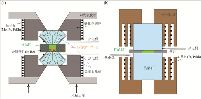
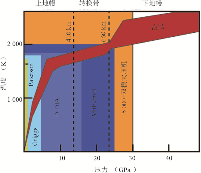
State⁃of⁃art high⁃temperature⁃pressure apparatus and characterization technology are the key way to know the occurrence state of deep earth materials and their effects on geological processes. In the past twenty years, lots of high⁃level high temperature and high pressure experimental platforms were set up in domestic universities and institutes of Earth sciences, which have diverse apparatus covering the temperature⁃pressure conditions of the Earth's surface to the core and various in⁃situ/ex⁃situ characterization techniques. The important progresses of experimental geosciences have been obtained in high⁃pressure mineral physics, experimental petrology and geochemistry etc. Innovative development of devices and technologies is one of key drivers for the basic theory innovations in the country's biggest strategic needs (such as deep earth, deep sea, deep space and Earth system science). Here we review the developed high⁃temperature⁃pressure apparatus and technologies, their challenges, and look into future perspectives.
State⁃of⁃art high⁃temperature⁃pressure apparatus and characterization technology are the key way to know the occurrence state of deep earth materials and their effects on geological processes. In the past twenty years, lots of high⁃level high temperature and high pressure experimental platforms were set up in domestic universities and institutes of Earth sciences, which have diverse apparatus covering the temperature⁃pressure conditions of the Earth's surface to the core and various in⁃situ/ex⁃situ characterization techniques. The important progresses of experimental geosciences have been obtained in high⁃pressure mineral physics, experimental petrology and geochemistry etc. Innovative development of devices and technologies is one of key drivers for the basic theory innovations in the country's biggest strategic needs (such as deep earth, deep sea, deep space and Earth system science). Here we review the developed high⁃temperature⁃pressure apparatus and technologies, their challenges, and look into future perspectives.


2022, 47(8): 2765-2780.
doi: 10.3799/dqkx.2021.151
Abstract:
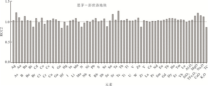
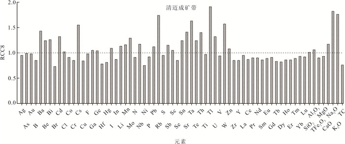
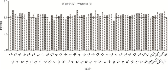
Laos has excellent ore⁃forming geological conditions and great resource potentials. The 1: 1 000 000 National⁃scale Geochemical Mapping project was conducted in the whole area of Laosat the advocate of the "Belt and Road" Initiative.A large amount of geochemical data was collected, which provided high⁃quality basic geochemical data for the study on elemental dispersion and enrichment, mineral exploration, environmental protection and agricultural production.A total of 2079 geochemical samples were collected, 69 elements were analyzed by high⁃precision analytical techniques under the strict quality control. The data set was once processed by the X±3S and the anisotropy was dropped, the median value of the processed data set was used as the valuation. As a result, the first batch of geochemical background values of 69 elements of the Laos was acquired, which filled the gap of national⁃scale geochemical mapping work in Laos. The characteristics of 69⁃element background values of Laos, 7 tertiary geotectonic units and 6 tertiary metallogenic belts throughout Laos are primarily discussed. The study shows that the distribution of elements in different tectonic units is characterized by geological background, tectonic and magmatic activities, while the distribution of elements in different mineralization zones are different due to the influence of mineralization and tectonic magmatic activities, and the enrichment of elements is a good indicator of mineral deposits. The acquisition of these background values provides basic comparative data for the next in⁃depth study of geochemical mapping data in Laos.
Laos has excellent ore⁃forming geological conditions and great resource potentials. The 1: 1 000 000 National⁃scale Geochemical Mapping project was conducted in the whole area of Laosat the advocate of the "Belt and Road" Initiative.A large amount of geochemical data was collected, which provided high⁃quality basic geochemical data for the study on elemental dispersion and enrichment, mineral exploration, environmental protection and agricultural production.A total of 2079 geochemical samples were collected, 69 elements were analyzed by high⁃precision analytical techniques under the strict quality control. The data set was once processed by the X±3S and the anisotropy was dropped, the median value of the processed data set was used as the valuation. As a result, the first batch of geochemical background values of 69 elements of the Laos was acquired, which filled the gap of national⁃scale geochemical mapping work in Laos. The characteristics of 69⁃element background values of Laos, 7 tertiary geotectonic units and 6 tertiary metallogenic belts throughout Laos are primarily discussed. The study shows that the distribution of elements in different tectonic units is characterized by geological background, tectonic and magmatic activities, while the distribution of elements in different mineralization zones are different due to the influence of mineralization and tectonic magmatic activities, and the enrichment of elements is a good indicator of mineral deposits. The acquisition of these background values provides basic comparative data for the next in⁃depth study of geochemical mapping data in Laos.


2022, 47(8): 2781-2794.
doi: 10.3799/dqkx.2021.128
Abstract:
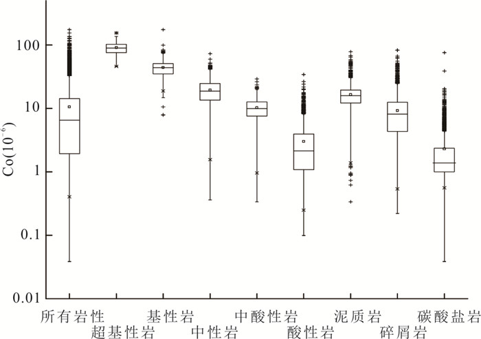
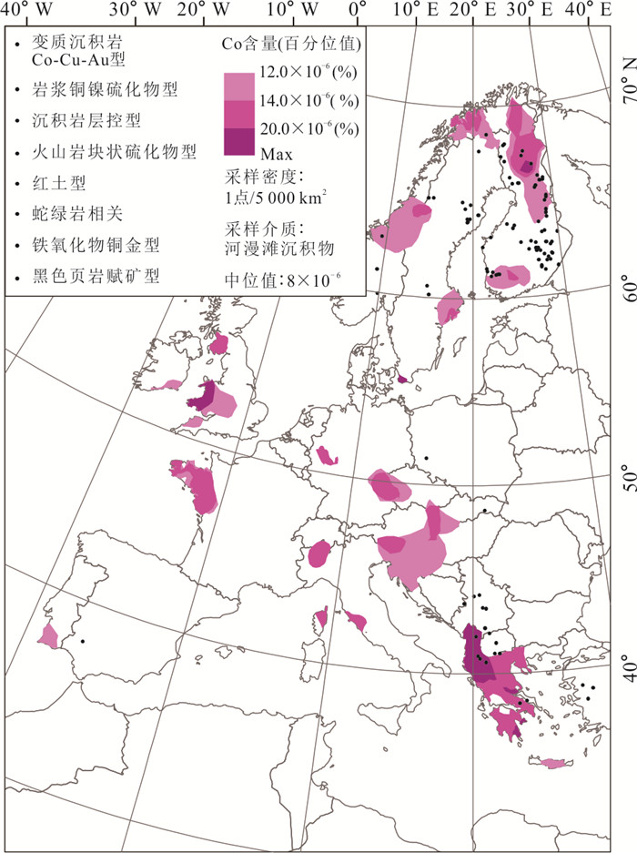
In recent years, the strategic position of cobalt resources has risen sharply, and cobalt resource exploration has also received increasing attention. However, the mineralization of cobalt is special, and whether extremely low⁃density geochemical mapping can provide a reliable basis for cobalt resource exploration remains to be studied.This paper conducts research on the geochemical anomalies of cobalt in deep catchment sediments obtained by the China Geochemical Baselines project, and finds that cobalt anomalies are mainly controlled by ultrabasic/basic rocks, and a few are related to mineralization. Lesser cobalt anomalies are related to argillaceous rock sand secondary enrichment. Establishing a spatial correlative index between deposits and anomalies, and quantitatively evaluating the relative spatial relationship between deposits and anomalies.Both China and Europe (FOREGS project) show that the spatial correspondence relationship of anomalies with weathered, hydrothermal, and magmatic type of cobalt deposits gradually weakened. Based on the above understanding, combined with the metallogenic background of China's cobalt, several cobalt metallogenic prospecting areas have been delineated in the South China and the eastern section of the northern margin of the North China Craton cobalt metallogenic belt.
In recent years, the strategic position of cobalt resources has risen sharply, and cobalt resource exploration has also received increasing attention. However, the mineralization of cobalt is special, and whether extremely low⁃density geochemical mapping can provide a reliable basis for cobalt resource exploration remains to be studied.This paper conducts research on the geochemical anomalies of cobalt in deep catchment sediments obtained by the China Geochemical Baselines project, and finds that cobalt anomalies are mainly controlled by ultrabasic/basic rocks, and a few are related to mineralization. Lesser cobalt anomalies are related to argillaceous rock sand secondary enrichment. Establishing a spatial correlative index between deposits and anomalies, and quantitatively evaluating the relative spatial relationship between deposits and anomalies.Both China and Europe (FOREGS project) show that the spatial correspondence relationship of anomalies with weathered, hydrothermal, and magmatic type of cobalt deposits gradually weakened. Based on the above understanding, combined with the metallogenic background of China's cobalt, several cobalt metallogenic prospecting areas have been delineated in the South China and the eastern section of the northern margin of the North China Craton cobalt metallogenic belt.


2022, 47(8): 2795-2808.
doi: 10.3799/dqkx.2022.054
Abstract:
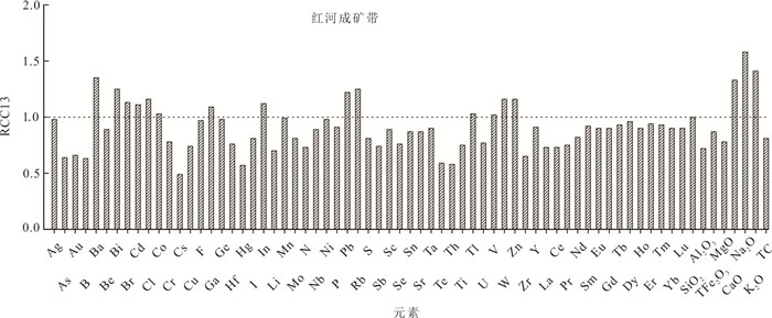
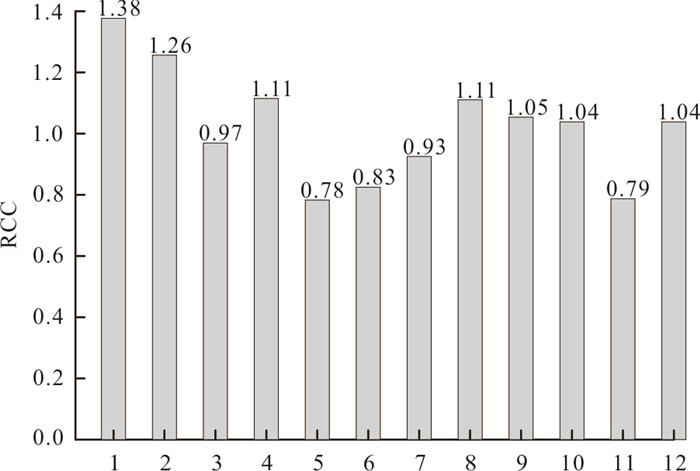
The Sino⁃Mongolia border areas are advantage in ore⁃forming geological conditions and have huge resource potentials, which make them the hotspot for international and domestic geoscience research and exploration. Lithium energy has been recognized as the developing trend of future new energy, and lithium ore has become a hotspot in the investigation and research of strategic mineral resources.With the ever⁃increasing demand for lithium, understanding its concentration and distribution in thepedosphere is essential for alleviating the lithium shortage in China.Based on the 1︰1 million geochemical mapping data of the Sino⁃Mongolia border areas, this paper discusses the geochemical parameters, regional geochemical distribution and influencing factors of lithium in the catchment sediments. The median and average values of lithium in the catchment sediments are 22.50×10⁻⁶ and 24.46×10⁻⁶, respectively. The Altay tectonic belt and the arc basin system at the Altay southern margin have the highest lithium contents, with the regional concentration coefficients of 1.38 and 1.26, respectively, which are the preponderant regions of lithium enrichment. The regional geochemical distribution of lithium is mainly controlled by the geological background, while the geographical landscape, clay content, and mineral deposit distribution can also restrict the distribution patterns of lithium. Based on the 85% cumulative frequency, 74 lithium geochemical anomalies are delineated, of which 23 lithium geochemical anomalies reach the scale of geochemical province. These anomalies provide the important selection areas for exploring lithium and other rare metal deposits in this area. The paper fills the gap in the lithium geochemical distribution study and provides important data for the comparison of rare metal deposits in the Sino⁃Mongolia border areas, and delineates prospecting targets for alleviating the Li shortage in China.
The Sino⁃Mongolia border areas are advantage in ore⁃forming geological conditions and have huge resource potentials, which make them the hotspot for international and domestic geoscience research and exploration. Lithium energy has been recognized as the developing trend of future new energy, and lithium ore has become a hotspot in the investigation and research of strategic mineral resources.With the ever⁃increasing demand for lithium, understanding its concentration and distribution in thepedosphere is essential for alleviating the lithium shortage in China.Based on the 1︰1 million geochemical mapping data of the Sino⁃Mongolia border areas, this paper discusses the geochemical parameters, regional geochemical distribution and influencing factors of lithium in the catchment sediments. The median and average values of lithium in the catchment sediments are 22.50×10⁻⁶ and 24.46×10⁻⁶, respectively. The Altay tectonic belt and the arc basin system at the Altay southern margin have the highest lithium contents, with the regional concentration coefficients of 1.38 and 1.26, respectively, which are the preponderant regions of lithium enrichment. The regional geochemical distribution of lithium is mainly controlled by the geological background, while the geographical landscape, clay content, and mineral deposit distribution can also restrict the distribution patterns of lithium. Based on the 85% cumulative frequency, 74 lithium geochemical anomalies are delineated, of which 23 lithium geochemical anomalies reach the scale of geochemical province. These anomalies provide the important selection areas for exploring lithium and other rare metal deposits in this area. The paper fills the gap in the lithium geochemical distribution study and provides important data for the comparison of rare metal deposits in the Sino⁃Mongolia border areas, and delineates prospecting targets for alleviating the Li shortage in China.


2022, 47(8): 2809-2823.
doi: 10.3799/dqkx.2021.252
Abstract:
Erlian Basin is one of the most important uranium ore producers in China, in which a series of sandstone⁃type uranium deposits have been continuously discovered including the Nuheting giant uranium deposit and Saihangaobi medium⁃sized deposit. A number of Paleozoic to Mesozoic granite intrusions emplaced in the northern and southern margin of Saihangaobi⁃Sunitezuoqi area, which provided abundant uranium source. In addition, NE⁃trending Bayanwula and Saihangaobi paleo⁃channel sand body in this region provided favorable tectonic conditions for the formation and preservation of uranium orebodies. At present, geophysical exploration (electric, seismic, gravity, aeromagnetic) and drilling are the main exploration methods for sandstone⁃type uranium deposits in this area, while conventional geochemical exploration is seldom carried out in this area, or the effect is not satisfied. Given the development of deep penetrating geochemistry theory, fine⁃grained soil prospecting method has raised attention in the exploration practice of uranium deposit in sedimentary basins of northern China. To meet the needs of large⁃scale prospecting, the regional 1: 250 000 geochemical scanning is carried out in the Sihangaobi⁃Sunitezuoqi area of middle Erlian basin based on fine⁃grained soil prospecting method in this study. A total of 2 821 samples were collected and analyzed, the results show that Hg, As, Mo, F, Zr, Sr, Sb, Li, Th and U not only have relatively high enrichment coefficients, but also show relatively high variable coefficients. These elements could be divided into two groups including Zr⁃Th⁃U⁃Mo and As⁃Sb⁃F⁃Li⁃Sr⁃Hg, and U⁃Mo are selected as mineralized indicators of uranium deposit based on the element correlation analysis and R⁃type clustering analysis. The high abundance of U ad Mo is closely associated with widely⁃distributed granitic plutons and paleo⁃channel sand body. Three favorable prospecting places are delineated based on the U⁃Mo comprehensive abnormal development area. The No. I and No. II favorable prospecting places are located in the depression of Erlian basin, and the uranium anomalies in this place are caused by the distribution of paleo⁃channel sand body, indicating that No. I and No. II have great potentials to explore sandstone⁃type uranium deposit.
Erlian Basin is one of the most important uranium ore producers in China, in which a series of sandstone⁃type uranium deposits have been continuously discovered including the Nuheting giant uranium deposit and Saihangaobi medium⁃sized deposit. A number of Paleozoic to Mesozoic granite intrusions emplaced in the northern and southern margin of Saihangaobi⁃Sunitezuoqi area, which provided abundant uranium source. In addition, NE⁃trending Bayanwula and Saihangaobi paleo⁃channel sand body in this region provided favorable tectonic conditions for the formation and preservation of uranium orebodies. At present, geophysical exploration (electric, seismic, gravity, aeromagnetic) and drilling are the main exploration methods for sandstone⁃type uranium deposits in this area, while conventional geochemical exploration is seldom carried out in this area, or the effect is not satisfied. Given the development of deep penetrating geochemistry theory, fine⁃grained soil prospecting method has raised attention in the exploration practice of uranium deposit in sedimentary basins of northern China. To meet the needs of large⁃scale prospecting, the regional 1: 250 000 geochemical scanning is carried out in the Sihangaobi⁃Sunitezuoqi area of middle Erlian basin based on fine⁃grained soil prospecting method in this study. A total of 2 821 samples were collected and analyzed, the results show that Hg, As, Mo, F, Zr, Sr, Sb, Li, Th and U not only have relatively high enrichment coefficients, but also show relatively high variable coefficients. These elements could be divided into two groups including Zr⁃Th⁃U⁃Mo and As⁃Sb⁃F⁃Li⁃Sr⁃Hg, and U⁃Mo are selected as mineralized indicators of uranium deposit based on the element correlation analysis and R⁃type clustering analysis. The high abundance of U ad Mo is closely associated with widely⁃distributed granitic plutons and paleo⁃channel sand body. Three favorable prospecting places are delineated based on the U⁃Mo comprehensive abnormal development area. The No. I and No. II favorable prospecting places are located in the depression of Erlian basin, and the uranium anomalies in this place are caused by the distribution of paleo⁃channel sand body, indicating that No. I and No. II have great potentials to explore sandstone⁃type uranium deposit.


2022, 47(8): 2824-2838.
doi: 10.3799/dqkx.2021.197
Abstract:
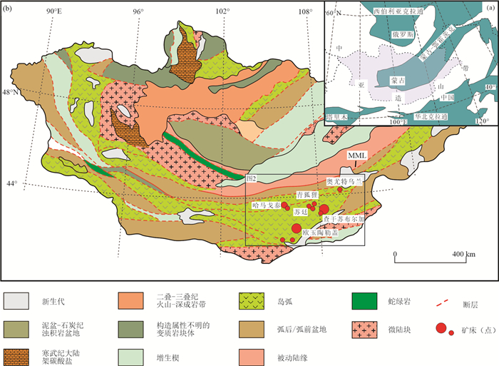
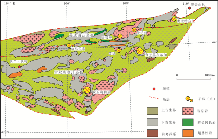
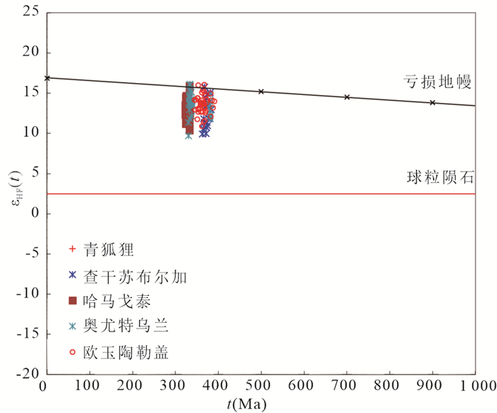
The Mandalovoo⁃Gurvansaikhan island⁃arc Terrane in South Mongolia is an important part of Central Asian Orogenic Belt (CAOB). In order to constrain the genetic relationship between the large⁃scale magmatism, porphyry⁃type Cu⁃polymetallic mineralization and regional crustal evolution, petrography, LA⁃MC⁃ICP⁃MS zircon geochronology and Hf⁃isotop were completed on the typical deposits. Based on geological evidence, the metallogenic⁃related rocks at Kharmagtai Cu⁃Au deposit is the andesite⁃monzodiorite porphyritem, and the LA⁃ICP⁃MS zircon U⁃Pb dating of them yields crystallization age of 332 to 324 Ma. The monzonitic granite hosting the Tsagaan Suvarga Cu⁃Mo ore⁃bodies and the diorite granodiorite porphyry related to Bronze Fox porphyry⁃type mineralization yield crystallization age of ~372 Ma and ~333 Ma respectively. The monzonite intrusions and andesite⁃granodiorite complexes at Oyut Ulaan were emplaced at ~381 Ma and 338 to 332 Ma. Based on geological evidence, and chronology data, the Late Paleozoic magmatic activity at Mandalovoo⁃Gurvansaikhan island⁃arc Terrane is mainly divided into three stages: 383 to 369 Ma, 367 to 363 Ma and 338 to 321 Ma. Among them, the metallogenic⁃related magmatic active are mainly concentrated in two periods of 375 to 369 Ma and 338 to 328 Ma, which may be the two most important mineralization periods in the region. Moreover, the in⁃situ zircon εHf(t) show positive values between +7.85 to +16.14, which are above the chondrite evolution line, partial sample are markedly close to the depleted mantle (DM) evolution line, indicating that the source of the diagenetic material may be the new material formed by the DM partial⁃melting, and the new material subject to partial melting after a short stay in the crust, mixed with a certain amount of mature crust. The tDM2 are 331~717 Ma, indicating that the time of important crustal accretion events in region is from Neoproterozoic to Late Paleozoic.
The Mandalovoo⁃Gurvansaikhan island⁃arc Terrane in South Mongolia is an important part of Central Asian Orogenic Belt (CAOB). In order to constrain the genetic relationship between the large⁃scale magmatism, porphyry⁃type Cu⁃polymetallic mineralization and regional crustal evolution, petrography, LA⁃MC⁃ICP⁃MS zircon geochronology and Hf⁃isotop were completed on the typical deposits. Based on geological evidence, the metallogenic⁃related rocks at Kharmagtai Cu⁃Au deposit is the andesite⁃monzodiorite porphyritem, and the LA⁃ICP⁃MS zircon U⁃Pb dating of them yields crystallization age of 332 to 324 Ma. The monzonitic granite hosting the Tsagaan Suvarga Cu⁃Mo ore⁃bodies and the diorite granodiorite porphyry related to Bronze Fox porphyry⁃type mineralization yield crystallization age of ~372 Ma and ~333 Ma respectively. The monzonite intrusions and andesite⁃granodiorite complexes at Oyut Ulaan were emplaced at ~381 Ma and 338 to 332 Ma. Based on geological evidence, and chronology data, the Late Paleozoic magmatic activity at Mandalovoo⁃Gurvansaikhan island⁃arc Terrane is mainly divided into three stages: 383 to 369 Ma, 367 to 363 Ma and 338 to 321 Ma. Among them, the metallogenic⁃related magmatic active are mainly concentrated in two periods of 375 to 369 Ma and 338 to 328 Ma, which may be the two most important mineralization periods in the region. Moreover, the in⁃situ zircon εHf(t) show positive values between +7.85 to +16.14, which are above the chondrite evolution line, partial sample are markedly close to the depleted mantle (DM) evolution line, indicating that the source of the diagenetic material may be the new material formed by the DM partial⁃melting, and the new material subject to partial melting after a short stay in the crust, mixed with a certain amount of mature crust. The tDM2 are 331~717 Ma, indicating that the time of important crustal accretion events in region is from Neoproterozoic to Late Paleozoic.


2022, 47(8): 2839-2855.
doi: 10.3799/dqkx.2021.162
Abstract:
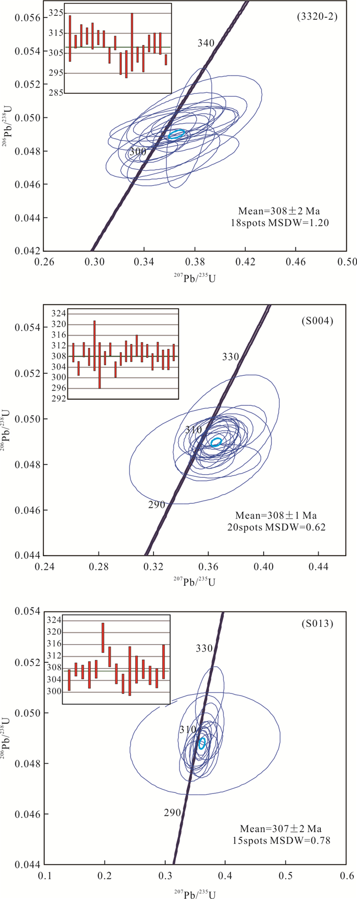
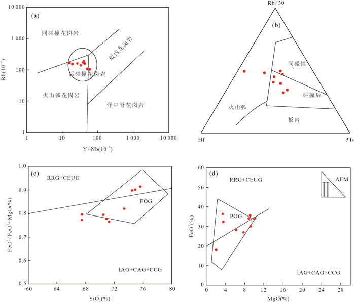
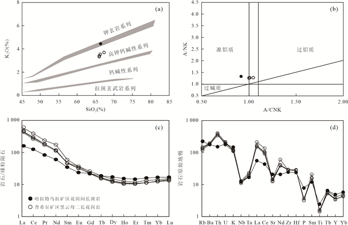
To determine the petrogenesis and tectonic setting of the Late Carboniferous monzogranite in the northern Great Xing'an Range, (Method) the paper analyzes the zircon U⁃Pb geochronology, Hf isotope and geochemistry of the monzogranite samples from Mianduhe area. The zircon U⁃Pb dating results show that the monzongranite was formed at 307⁃308 Ma, belonging to theLate Carboniferous.The characteristics of major elements reveal thatthe granite is characterized by alkali⁃rich(total alkali=7.28%⁃9.08%), high potassium (K2O=3.45%⁃5.54%) and weak peraluminous (A/CNK=1.02⁃1.19), suggesting that it can be classified as high potassium calc⁃alkaline Ⅰ⁃type granite.The characteristics of trace elements reveal thatthe granite has medium⁃negative Eu anomaly(δEu=0.29⁃0.77), obviously enriched LILES(Rb, K, Th and U)and LREE, significantly depleted HFSEs(Ti, Ta and Nb) and P. In addition, the Hf isotope characteristics show that the εHf(t) values range from +7.73 to +12.46, with the tDM2 age of 501⁃764 Ma, indicating that their parent magma was formed by partial melting of the Neoproterozoic juvenile lower crust under the amphibolite facies, and then experienced significant fraction crystallization.Combined with previous study, it is suggested that the Mianduhe monzogranite was responded for the collage of the Erguna⁃Xing'an block and the Songnen block in an post⁃collision setting during the Late Carboniferous.
To determine the petrogenesis and tectonic setting of the Late Carboniferous monzogranite in the northern Great Xing'an Range, (Method) the paper analyzes the zircon U⁃Pb geochronology, Hf isotope and geochemistry of the monzogranite samples from Mianduhe area. The zircon U⁃Pb dating results show that the monzongranite was formed at 307⁃308 Ma, belonging to theLate Carboniferous.The characteristics of major elements reveal thatthe granite is characterized by alkali⁃rich(total alkali=7.28%⁃9.08%), high potassium (K2O=3.45%⁃5.54%) and weak peraluminous (A/CNK=1.02⁃1.19), suggesting that it can be classified as high potassium calc⁃alkaline Ⅰ⁃type granite.The characteristics of trace elements reveal thatthe granite has medium⁃negative Eu anomaly(δEu=0.29⁃0.77), obviously enriched LILES(Rb, K, Th and U)and LREE, significantly depleted HFSEs(Ti, Ta and Nb) and P. In addition, the Hf isotope characteristics show that the εHf(t) values range from +7.73 to +12.46, with the tDM2 age of 501⁃764 Ma, indicating that their parent magma was formed by partial melting of the Neoproterozoic juvenile lower crust under the amphibolite facies, and then experienced significant fraction crystallization.Combined with previous study, it is suggested that the Mianduhe monzogranite was responded for the collage of the Erguna⁃Xing'an block and the Songnen block in an post⁃collision setting during the Late Carboniferous.


2022, 47(8): 2856-2870.
doi: 10.3799/dqkx.2021.136
Abstract:
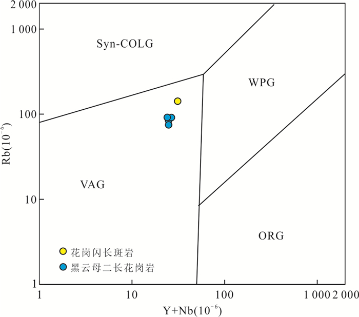
In order to reveal the relationship between the ore genesis and the evolution of Mongolia⁃Okhotsk Ocean, we studied the whole rock geochemistry, U⁃Pb ages and Hf isotopes of the zircons from the ore⁃related granodiorite porphyry inthe Haraat Uul Fe⁃Zn deposit and biotite monzogranite in theTsahir Fe⁃Mo deposit. The ore⁃related granites were formed at ca. 278 Ma for the Haraat Uul Fe⁃Zn deposit and ca. 258 Ma for the Tsahir Fe⁃Mo deposit. The granitic rocks have high contents of K2O and alkali, enrichments of LREE and LILEs (K, Rb), and depletions of HFSEs (Nb, Ta, Ti), which is indicative of high⁃K calc⁃alkaline Ⅰ⁃type granites. The granodiorite porphyry of the Haraat Uul Fe⁃Zn deposit has positive εHf(t) range of 6.6~9.8 with two⁃stage depleted mantle Hf model ages of 672~877 Ma; the biotite monzogranite for the Tsahir Fe⁃Mo deposit has positive εHf(t) range of 6.9~11.1 with two⁃stage depleted mantle Hf model ages of 568~855 Ma, indicating that both of the photoliths were probably derived from a Neoproterozoic depleted mantle. Fe polymetallic mineralisation at the Haraat Uul and Tsahir areas was intimately related to the south⁃eastward subduction of the Mongol⁃Okhotsk Ocean, indirectly proved that the Mongolian⁃Okhotsk Ocean plate began to south⁃eastward subduction before 278 Ma.
In order to reveal the relationship between the ore genesis and the evolution of Mongolia⁃Okhotsk Ocean, we studied the whole rock geochemistry, U⁃Pb ages and Hf isotopes of the zircons from the ore⁃related granodiorite porphyry inthe Haraat Uul Fe⁃Zn deposit and biotite monzogranite in theTsahir Fe⁃Mo deposit. The ore⁃related granites were formed at ca. 278 Ma for the Haraat Uul Fe⁃Zn deposit and ca. 258 Ma for the Tsahir Fe⁃Mo deposit. The granitic rocks have high contents of K2O and alkali, enrichments of LREE and LILEs (K, Rb), and depletions of HFSEs (Nb, Ta, Ti), which is indicative of high⁃K calc⁃alkaline Ⅰ⁃type granites. The granodiorite porphyry of the Haraat Uul Fe⁃Zn deposit has positive εHf(t) range of 6.6~9.8 with two⁃stage depleted mantle Hf model ages of 672~877 Ma; the biotite monzogranite for the Tsahir Fe⁃Mo deposit has positive εHf(t) range of 6.9~11.1 with two⁃stage depleted mantle Hf model ages of 568~855 Ma, indicating that both of the photoliths were probably derived from a Neoproterozoic depleted mantle. Fe polymetallic mineralisation at the Haraat Uul and Tsahir areas was intimately related to the south⁃eastward subduction of the Mongol⁃Okhotsk Ocean, indirectly proved that the Mongolian⁃Okhotsk Ocean plate began to south⁃eastward subduction before 278 Ma.


2022, 47(8): 2871-2888.
doi: 10.3799/dqkx.2021.092
Abstract:
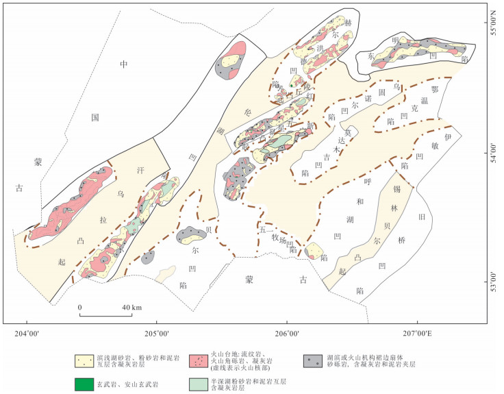
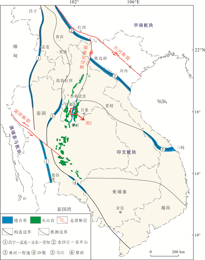
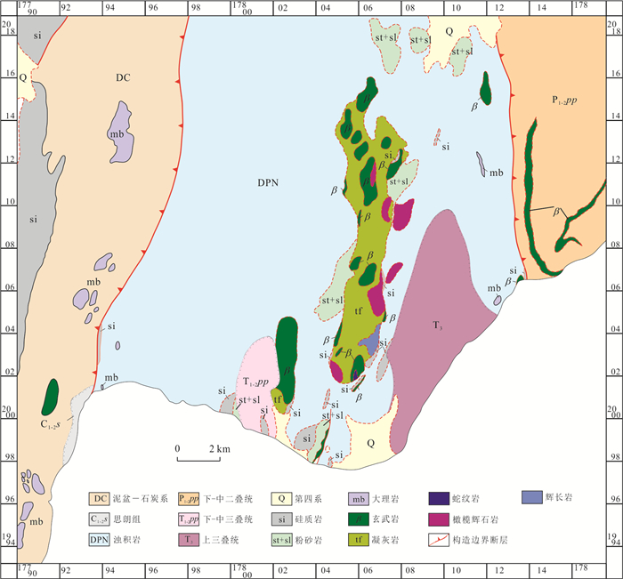
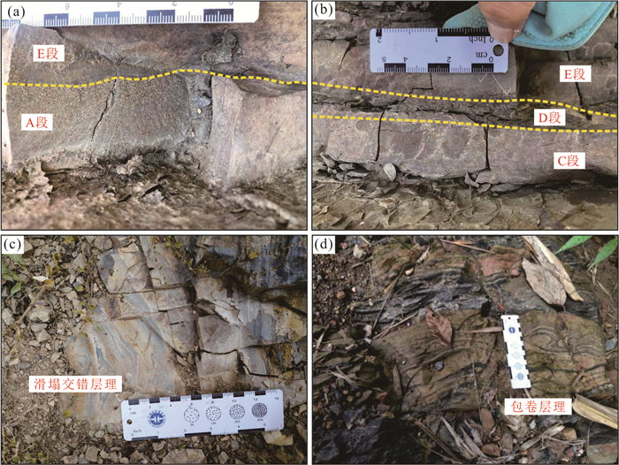
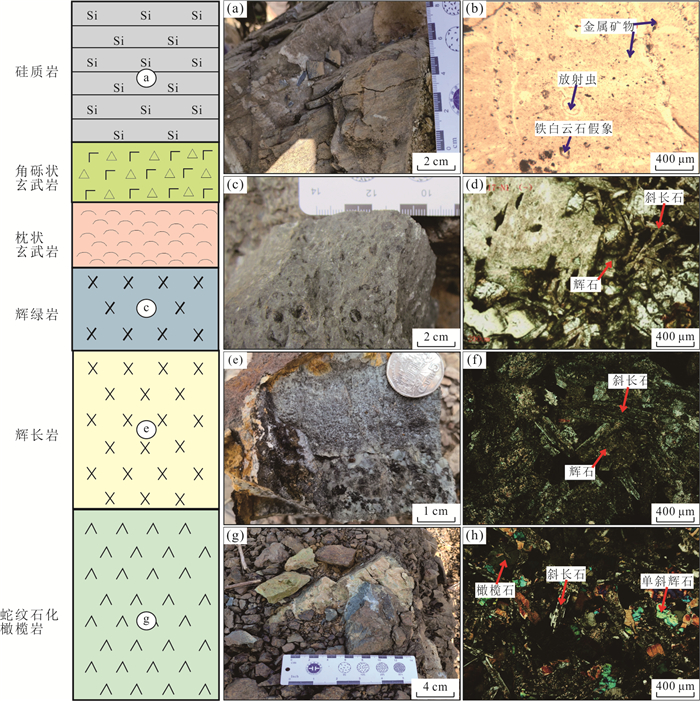
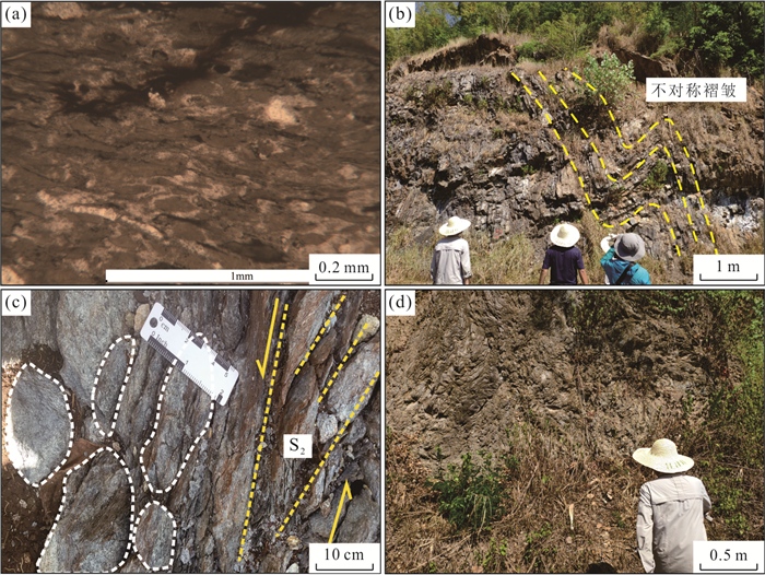
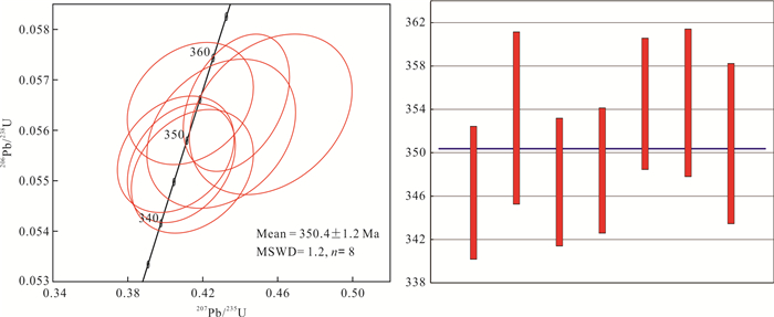
The Tethyan tectonic framework in Southeast Asia is complex, especially the tectonic evolution history and tectonic belt connection of Luang Prabang⁃Loei tectonic belt on the western margin of the Indo china block is more controversial. Basing on the geological mapping work, we discovered for the first time a well⁃preserved ophiolitic complex in the Namhonr area, northern Loei tectonic belt. In order to explore the attributes of the Loei tectonic belt and the regional paleogeographic pattern, the lithology identification for the ophiolitic complex, zircon LA⁃ICP⁃MS U⁃Pb dating forthe gabbro, paleobiology and major and trace elements for the radiolarian chert and reef limestone are presented in this paper. The results show that the outcroped end members of the ophiolitic complex include serpentinite, serpentinized peridotite, gabbro, diorite, basalt and siliceous rock, which display a complete sequence of ophiolitic complex. The LA⁃ICP⁃MS U⁃Pb ages of gabbro is 350.4±3.3 Ma, indicating the gabbro was formed in the Early Carboniferous. The coral species in the oceanic island⁃seamount are Thamnopora sp. and Paracravenia sp. which belong to the Middle Permian. The geochemical characteristics of the siliceous rock indicate that it is of biological origin and the sedimentary environment is an ocean basin or an open basin environment. A total of 30 species of radiolarians have been identified in 9 genera, which belong to the Middle Devonian⁃Early Carboniferous. The results of this research reflect that the ocean basin represented by the ophiolitic complex in the Namhonr area has a long⁃term evolution history, starting from the Late Devonian and continuing to the Middle Permian, the evolution duration is at least 135 Ma, indicating that the ophiolitic complex represents the residual Paleo⁃Tethys ocean basin, not the back⁃arc basin. We believe that the Loei tectonic belt should be connected to the Luang Prabang tectonic belt to the north, the Paleo⁃Tethys Ocean has existed in this area since the Late Devonian.
The Tethyan tectonic framework in Southeast Asia is complex, especially the tectonic evolution history and tectonic belt connection of Luang Prabang⁃Loei tectonic belt on the western margin of the Indo china block is more controversial. Basing on the geological mapping work, we discovered for the first time a well⁃preserved ophiolitic complex in the Namhonr area, northern Loei tectonic belt. In order to explore the attributes of the Loei tectonic belt and the regional paleogeographic pattern, the lithology identification for the ophiolitic complex, zircon LA⁃ICP⁃MS U⁃Pb dating forthe gabbro, paleobiology and major and trace elements for the radiolarian chert and reef limestone are presented in this paper. The results show that the outcroped end members of the ophiolitic complex include serpentinite, serpentinized peridotite, gabbro, diorite, basalt and siliceous rock, which display a complete sequence of ophiolitic complex. The LA⁃ICP⁃MS U⁃Pb ages of gabbro is 350.4±3.3 Ma, indicating the gabbro was formed in the Early Carboniferous. The coral species in the oceanic island⁃seamount are Thamnopora sp. and Paracravenia sp. which belong to the Middle Permian. The geochemical characteristics of the siliceous rock indicate that it is of biological origin and the sedimentary environment is an ocean basin or an open basin environment. A total of 30 species of radiolarians have been identified in 9 genera, which belong to the Middle Devonian⁃Early Carboniferous. The results of this research reflect that the ocean basin represented by the ophiolitic complex in the Namhonr area has a long⁃term evolution history, starting from the Late Devonian and continuing to the Middle Permian, the evolution duration is at least 135 Ma, indicating that the ophiolitic complex represents the residual Paleo⁃Tethys ocean basin, not the back⁃arc basin. We believe that the Loei tectonic belt should be connected to the Luang Prabang tectonic belt to the north, the Paleo⁃Tethys Ocean has existed in this area since the Late Devonian.


2022, 47(8): 2889-2901.
doi: 10.3799/dqkx.2021.129
Abstract:
TheLate Jurassic⁃Early Cretaceous granites are widely developed in the west slop of Southern Great Xing'an Range, and an in⁃depth study of the petrogenesis is of great geological significance to reveal the Mesozoic geodynamic background and tectonic evolution. In this paper, we report for the zircon LA⁃ICP⁃MS U⁃Pb age and Hf isotopic data, whole⁃rock major and trace element composition data from Xiaowulangousyeno granite. LA⁃ICP⁃MS U⁃Pb dating yields a weighted mean of 139.4±0.7 Ma, indicating that Xiaowulangousyeno granite formed in the Early Cretaceous. Geochemically, the syenogranite belongs to Si⁃K⁃rich calc⁃alkaline series, A/CNK=1.00~1.11 and are weak peraluminous. The syenogranite enriched in Rb, Th, U(LILE) and light rare earth elements(LREE), relatively depleted in Ba, Sr, P, Ti(HFSE), withobvious Eu negative anomaly(δEu=0.007~0.009). In addition, the (Zr+Nb+Ce+Y) values of syenograniteis less than 350×10⁃6. The syenogranite contains magnetite, and no primary muscovite and alkaline mafic minerals. All these features above suggest that Xiaowulangousyenogranite belongs to highly fractionated Ⅰ⁃type granite. The zircons εHf(t) values of syenogranite are +5.5~+8.9, and the two stage model ages (tDM2) range 700 Ma to 947 Ma. Combined with the reginoal geological background, we conclude that the Xiaowulangousyenograniteoriginated from the partial melting of upper Proterozoic meta⁃mafic rocks and middle Ordovician meta⁃andesite rocks under low pressure and high temperature, and the syenogranitewas the product of extension after the closure of Mongol⁃Okhotsk Ocean.
TheLate Jurassic⁃Early Cretaceous granites are widely developed in the west slop of Southern Great Xing'an Range, and an in⁃depth study of the petrogenesis is of great geological significance to reveal the Mesozoic geodynamic background and tectonic evolution. In this paper, we report for the zircon LA⁃ICP⁃MS U⁃Pb age and Hf isotopic data, whole⁃rock major and trace element composition data from Xiaowulangousyeno granite. LA⁃ICP⁃MS U⁃Pb dating yields a weighted mean of 139.4±0.7 Ma, indicating that Xiaowulangousyeno granite formed in the Early Cretaceous. Geochemically, the syenogranite belongs to Si⁃K⁃rich calc⁃alkaline series, A/CNK=1.00~1.11 and are weak peraluminous. The syenogranite enriched in Rb, Th, U(LILE) and light rare earth elements(LREE), relatively depleted in Ba, Sr, P, Ti(HFSE), withobvious Eu negative anomaly(δEu=0.007~0.009). In addition, the (Zr+Nb+Ce+Y) values of syenograniteis less than 350×10⁃6. The syenogranite contains magnetite, and no primary muscovite and alkaline mafic minerals. All these features above suggest that Xiaowulangousyenogranite belongs to highly fractionated Ⅰ⁃type granite. The zircons εHf(t) values of syenogranite are +5.5~+8.9, and the two stage model ages (tDM2) range 700 Ma to 947 Ma. Combined with the reginoal geological background, we conclude that the Xiaowulangousyenograniteoriginated from the partial melting of upper Proterozoic meta⁃mafic rocks and middle Ordovician meta⁃andesite rocks under low pressure and high temperature, and the syenogranitewas the product of extension after the closure of Mongol⁃Okhotsk Ocean.


2022, 47(8): 2902-2924.
doi: 10.3799/dqkx.2021.163
Abstract:
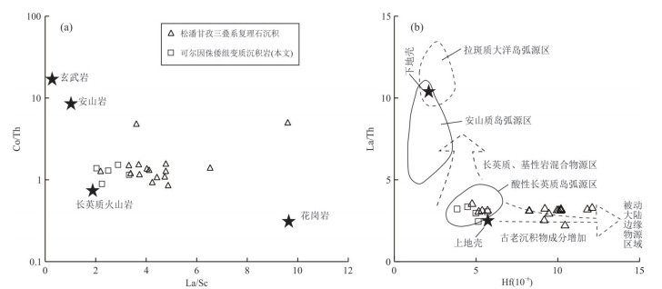
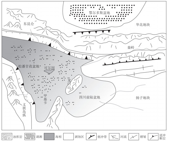
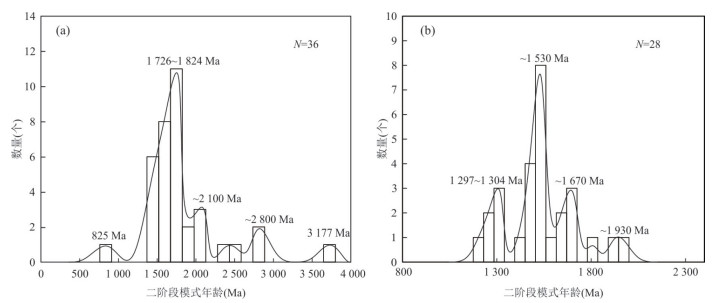
In order to decipher the provenance system of the Triassic Zhuwo Formation meta⁃sedimentary rocks and its genetic relationship with Lijiagou pegmatite in Ke'eryin area, LA⁃ICP⁃MS U⁃Pb micro⁃dating, Lu⁃Hf isotope analysis of detrital zircons and whole⁃rock geochemical analysis of meta⁃sedimentary rocks were conducted. Geochemical analysis results show that the meta⁃sedimentary rocks of Zhuwo Formation are characterized by high SiO2 and Al2O3 content. The chondrite⁃normalized REE patterns are characterised by light REE enrichment, which is similar to the Late Archean sedimentary rocks in Australia(PASS). Detrital Zircons show magmatic oscillating zonation, and are partially sorrounded by metamorphic accretionary rims due to recrystallization.U⁃Pb age of detrital zircons yields two main clusters at 313~227 Ma and 461~401 Ma, as well as two minor clusters at 938~774 Ma and 2 048~1 928 Ma. εHf(t) values of detrital zircons varies from -17.1 to +13.3 with two⁃stage Hf model ages(TDM2) of 3 240~499 Ma. Based on the results above, we conclude that the provenance of Zhuwo Formation meta⁃sedimentary rocks in Ke'eryin includes felsicrocks from continental arcsac companied by some recycled materials mainly receiving materials from East Kunlun, North Qinling orogenic belt and Yangtze blocks. Lijiagou pegmatite in Ke'eryin area was formed by direct partial melting of Triassic Zhuwo Formation meta⁃sedimentary rocks.
In order to decipher the provenance system of the Triassic Zhuwo Formation meta⁃sedimentary rocks and its genetic relationship with Lijiagou pegmatite in Ke'eryin area, LA⁃ICP⁃MS U⁃Pb micro⁃dating, Lu⁃Hf isotope analysis of detrital zircons and whole⁃rock geochemical analysis of meta⁃sedimentary rocks were conducted. Geochemical analysis results show that the meta⁃sedimentary rocks of Zhuwo Formation are characterized by high SiO2 and Al2O3 content. The chondrite⁃normalized REE patterns are characterised by light REE enrichment, which is similar to the Late Archean sedimentary rocks in Australia(PASS). Detrital Zircons show magmatic oscillating zonation, and are partially sorrounded by metamorphic accretionary rims due to recrystallization.U⁃Pb age of detrital zircons yields two main clusters at 313~227 Ma and 461~401 Ma, as well as two minor clusters at 938~774 Ma and 2 048~1 928 Ma. εHf(t) values of detrital zircons varies from -17.1 to +13.3 with two⁃stage Hf model ages(TDM2) of 3 240~499 Ma. Based on the results above, we conclude that the provenance of Zhuwo Formation meta⁃sedimentary rocks in Ke'eryin includes felsicrocks from continental arcsac companied by some recycled materials mainly receiving materials from East Kunlun, North Qinling orogenic belt and Yangtze blocks. Lijiagou pegmatite in Ke'eryin area was formed by direct partial melting of Triassic Zhuwo Formation meta⁃sedimentary rocks.


2022, 47(8): 2925-2939.
doi: 10.3799/dqkx.2022.175
Abstract:
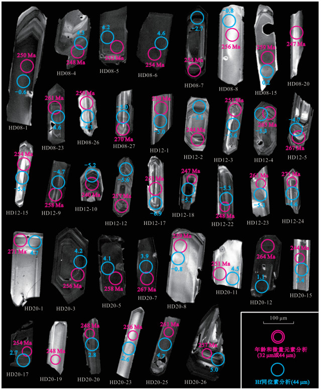
The volcanisms of the Guadalupian⁃Lopingian (also middle⁃late Permian) and Permian⁃Triassic boundaries in South China have attracted increasing attentions from geologists. In contrast, less studies concerned the volcanisms between the two. Here, we report geochemical studies on volcanisms near the Wuchiapingian ⁃ Changhsingian boundary within the late Permian from the Dawoling section of Jiahe Area, Hunan Province, South China, in which three layers of claystones, named as HD08, HD12 and HD20, are pronounced in the Wuchiapingian⁃Changhsingian boundary beds that are calibrated to the lower and middle Dalong Formation. The integrated analyses of whole⁃rock geochemistry, zircon U⁃Pb chronology, trace elements and Lu⁃Hf isotopes reveal that these three claystones originated from altered volcanic ashes, representing three episodes volcanism across the Wuchiapingian⁃Changhsingian boundary. The whole⁃rock and zircon trace element signatures indicate that the volcanic ashes originated from rhyolitic or rhyodacitic volcanism, with calc⁃alkaline affinities, and formed in post⁃collisional tectonic settings in the convergent continental margins. Among them, εHf(t) values of HD08 and HD20 are -6.4 to 7.1, with a wide range of variability, and the magma originates from the mixing of Emeishan/Neoproterozoic neogenic crustal materials of and ancient crustal materials; εHf(t) values of HD12 are -12.0 to -3.5, and the magma mainly originates from ancient crustal materials. These three volcanic ash layers, together with previous researches, further confirm the occurrence of intense felsic volcanisms related to the convergence of the Pangea supercontinent in the areas around the South China block during the middle of the Lopingian (late Permian).
The volcanisms of the Guadalupian⁃Lopingian (also middle⁃late Permian) and Permian⁃Triassic boundaries in South China have attracted increasing attentions from geologists. In contrast, less studies concerned the volcanisms between the two. Here, we report geochemical studies on volcanisms near the Wuchiapingian ⁃ Changhsingian boundary within the late Permian from the Dawoling section of Jiahe Area, Hunan Province, South China, in which three layers of claystones, named as HD08, HD12 and HD20, are pronounced in the Wuchiapingian⁃Changhsingian boundary beds that are calibrated to the lower and middle Dalong Formation. The integrated analyses of whole⁃rock geochemistry, zircon U⁃Pb chronology, trace elements and Lu⁃Hf isotopes reveal that these three claystones originated from altered volcanic ashes, representing three episodes volcanism across the Wuchiapingian⁃Changhsingian boundary. The whole⁃rock and zircon trace element signatures indicate that the volcanic ashes originated from rhyolitic or rhyodacitic volcanism, with calc⁃alkaline affinities, and formed in post⁃collisional tectonic settings in the convergent continental margins. Among them, εHf(t) values of HD08 and HD20 are -6.4 to 7.1, with a wide range of variability, and the magma originates from the mixing of Emeishan/Neoproterozoic neogenic crustal materials of and ancient crustal materials; εHf(t) values of HD12 are -12.0 to -3.5, and the magma mainly originates from ancient crustal materials. These three volcanic ash layers, together with previous researches, further confirm the occurrence of intense felsic volcanisms related to the convergence of the Pangea supercontinent in the areas around the South China block during the middle of the Lopingian (late Permian).


2022, 47(8): 2940-2950.
doi: 10.3799/dqkx.2021.216
Abstract:
The Haidewula uranium deposit, which is located in the eastern part of the East Kunlun orogenic belt, is the newly discovered independenturanium mineralization deposit related to volcanic rocks in northwest China. Therefore, the study on this deposit is beneficial to reveal the formation mechanism of hydrothermal uranium mineralization in the Qinghai⁃Tibet Plateau.In this paper, scanning electron microscope, electron probe analysis, and Laser Ablation Inductively Coupled Plasma Mass Spectrometry in⁃situ analysis were carried out to explore the metallogenic age and genesis of the pitchblende at the Haidewula deposit. Analysis results show that the pitchblende shows high Ca and ∑REE contents and low LREE/HREE ratios.It has a U⁃Th⁃Pb chemical age of 226 to 350 Ma with a peak of 289 Ma, and a U⁃Pb isotopic age of 234.6±1.2 Ma (MSWD=0.99, n=17).The difference between the ages obtained by the two methods may be related to the inaccurate U⁃Th⁃Pb chemical age caused by a certain amount of common lead in the pitchblende of the Haidewula uranium deposit.We suggest that the pitchblende in the Haidewula uranium deposit were formed in post⁃magmatic Ca⁃rich medium⁃temperature hydrothermal fluids.And the formation of the Haidewula uranium deposit is related to the extensional environment after northward subduction⁃collision of the Buqingshan⁃Animaqing Ocean in the Paleo⁃Tethys tectonic domain.
The Haidewula uranium deposit, which is located in the eastern part of the East Kunlun orogenic belt, is the newly discovered independenturanium mineralization deposit related to volcanic rocks in northwest China. Therefore, the study on this deposit is beneficial to reveal the formation mechanism of hydrothermal uranium mineralization in the Qinghai⁃Tibet Plateau.In this paper, scanning electron microscope, electron probe analysis, and Laser Ablation Inductively Coupled Plasma Mass Spectrometry in⁃situ analysis were carried out to explore the metallogenic age and genesis of the pitchblende at the Haidewula deposit. Analysis results show that the pitchblende shows high Ca and ∑REE contents and low LREE/HREE ratios.It has a U⁃Th⁃Pb chemical age of 226 to 350 Ma with a peak of 289 Ma, and a U⁃Pb isotopic age of 234.6±1.2 Ma (MSWD=0.99, n=17).The difference between the ages obtained by the two methods may be related to the inaccurate U⁃Th⁃Pb chemical age caused by a certain amount of common lead in the pitchblende of the Haidewula uranium deposit.We suggest that the pitchblende in the Haidewula uranium deposit were formed in post⁃magmatic Ca⁃rich medium⁃temperature hydrothermal fluids.And the formation of the Haidewula uranium deposit is related to the extensional environment after northward subduction⁃collision of the Buqingshan⁃Animaqing Ocean in the Paleo⁃Tethys tectonic domain.


2022, 47(8): 2951-2967.
doi: 10.3799/dqkx.2021.154
Abstract:
Granite is the main component of continental crust, and the occurrence of Mesozoic granite in Jiaodong Peninsula is an important basis for deducing magmatic evolution and tectonic evolution of subduction plates. Therefore, the study of granite and its xenoliths (meta⁃maficrocks) exposed in Rushan area is helpful to better understand the magmatic evolution and crustal evolution of Jiaodong Peninsula in Mesozoic. This study provides new data of major and traceelements, U⁃Pb dataand Lu⁃Hf isotopesfor Jiaodong Peninsula. Petro⁃geochemistry shows that the biotite monzogranite has the characteristics of high potassium and calcium alkalinity, and is relatively poor in elements such as titanium, iron, manganese, and magnesium. The rock may be I⁃type or M⁃type granite with a high degree of differentiation.The large ion lithophile elements Ba and Sr are obviously enriched, and the high field strength element Zr has no obvious loss.The SiO2, TiO2, Fe2O3T, and MgO content of the amphibolite are 48.9%, 0.68%, 12.64% and 7.33%, respectively. It is a tholeiitic basalt composition, and the total alkali ALK (K2O+Na2O) is relatively low.The large ion lithophile elements Ba and Sr are not significantly enriched, and the high field strength element Zr is weakly depleted, which is similar to the geochemical properties of the garnet plagioclase amphibolite.The granite has magmatic zircon and the amphibolite contains metamorphic recrystallized zircon under zircon CL image. The zircon U⁃Pb dating age of the biotite monzogranite is 118.5±2.7 Ma, and the value of εHf(t) is -15.4 to -27.7 (Mean=-25.2±1.4), and the corresponding two⁃stage model age (TDM2) is 2.16 to 2.90 Ga, but most of them are concentrated in ~2.8 Ga.The upper intersection age amphibolite(xenoliths) is 1 839±27 Ma(zircon U⁃Pb), and and the value of εHf(t) is 0.5 to 5.1 (Mean=3.23±0.74), corresponding to the one⁃stage model age (TDM1) is 2.02 to 2.18 Ga.In addition, the value of εHf(t) of the granite⁃bearing granite in Niantou Village is -25.1 to -27.1 (Mean=-26.0±0.18), and the corresponding two⁃stage model age (TDM2) is 2.75 to 2.87 Ga.The εHf(t) value of the xenoliths (garnet amphibolite) is 3.7 to 4.4 (Mean=3.93±0.21), and the corresponding one⁃stage model age (TDM1) is 1.99 to 2.03 Ga.The above data indicate that the granite is the product of Archean crust remelting in the Eastern North China Craton; the meta⁃mafic rocks can be classified into the Jingshan Group of the North China Craton.Therefore, the Mesozoic granite and its xenoliths in the Rushan area have the same affiliation as the North China Craton. The granites with model ages of Archean age in the Rushan area suggest information about the crustal evolution of the Jiaodong Peninsula. It does not have the characteristics of magmatic rock produced by delamination. A short time after partial melting of the lower crust entrained, many ancient xenoliths (meta⁃mafic rocks) were carried to the subsurface by re⁃melting magma.
Granite is the main component of continental crust, and the occurrence of Mesozoic granite in Jiaodong Peninsula is an important basis for deducing magmatic evolution and tectonic evolution of subduction plates. Therefore, the study of granite and its xenoliths (meta⁃maficrocks) exposed in Rushan area is helpful to better understand the magmatic evolution and crustal evolution of Jiaodong Peninsula in Mesozoic. This study provides new data of major and traceelements, U⁃Pb dataand Lu⁃Hf isotopesfor Jiaodong Peninsula. Petro⁃geochemistry shows that the biotite monzogranite has the characteristics of high potassium and calcium alkalinity, and is relatively poor in elements such as titanium, iron, manganese, and magnesium. The rock may be I⁃type or M⁃type granite with a high degree of differentiation.The large ion lithophile elements Ba and Sr are obviously enriched, and the high field strength element Zr has no obvious loss.The SiO2, TiO2, Fe2O3T, and MgO content of the amphibolite are 48.9%, 0.68%, 12.64% and 7.33%, respectively. It is a tholeiitic basalt composition, and the total alkali ALK (K2O+Na2O) is relatively low.The large ion lithophile elements Ba and Sr are not significantly enriched, and the high field strength element Zr is weakly depleted, which is similar to the geochemical properties of the garnet plagioclase amphibolite.The granite has magmatic zircon and the amphibolite contains metamorphic recrystallized zircon under zircon CL image. The zircon U⁃Pb dating age of the biotite monzogranite is 118.5±2.7 Ma, and the value of εHf(t) is -15.4 to -27.7 (Mean=-25.2±1.4), and the corresponding two⁃stage model age (TDM2) is 2.16 to 2.90 Ga, but most of them are concentrated in ~2.8 Ga.The upper intersection age amphibolite(xenoliths) is 1 839±27 Ma(zircon U⁃Pb), and and the value of εHf(t) is 0.5 to 5.1 (Mean=3.23±0.74), corresponding to the one⁃stage model age (TDM1) is 2.02 to 2.18 Ga.In addition, the value of εHf(t) of the granite⁃bearing granite in Niantou Village is -25.1 to -27.1 (Mean=-26.0±0.18), and the corresponding two⁃stage model age (TDM2) is 2.75 to 2.87 Ga.The εHf(t) value of the xenoliths (garnet amphibolite) is 3.7 to 4.4 (Mean=3.93±0.21), and the corresponding one⁃stage model age (TDM1) is 1.99 to 2.03 Ga.The above data indicate that the granite is the product of Archean crust remelting in the Eastern North China Craton; the meta⁃mafic rocks can be classified into the Jingshan Group of the North China Craton.Therefore, the Mesozoic granite and its xenoliths in the Rushan area have the same affiliation as the North China Craton. The granites with model ages of Archean age in the Rushan area suggest information about the crustal evolution of the Jiaodong Peninsula. It does not have the characteristics of magmatic rock produced by delamination. A short time after partial melting of the lower crust entrained, many ancient xenoliths (meta⁃mafic rocks) were carried to the subsurface by re⁃melting magma.


2022, 47(8): 2968-2984.
doi: 10.3799/dqkx.2021.156
Abstract:
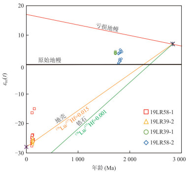
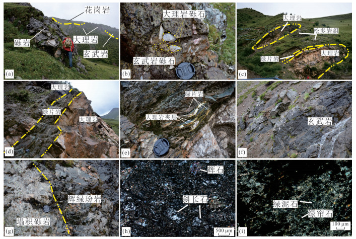
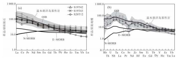
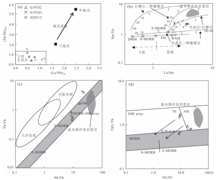
The Sumdo (Ultra)high Pressure Metamorphic Zone plays an important role in understanding the evolution of the Paleo Tethys Ocean in Tibet. However, there are few records about the early evolution of the ocean basin on behalf of this zone, which restricts the understanding of the evolution of the Paleo Tethys Ocean. In this paper, we have studied the field geological characteristics, magmatic whole rock geochemistry and zircon U⁃Pb chronology of the ocean island rock assemblages in Tangga area. The field geological characteristics of the ocean island rock assemblages in Tangga area show the typical "double layer structure", with basalt basement in the lower layer, limestone (marble) cover layer and colluvial conglomerate in the upper cover layer, and metamorphic basalt interbedded with marble and tuff in the upper cover layer, which is similar to the "Cape Verde" ocean island. Zircon U⁃Pb geochronology of two basalts and a diabase porphyrite dike is 330 Ma, 310 Ma and 307 Ma, respectively, indicating the least Early Carboniferous to Late Carboniferous. Both basalt and diabase porphyrite have high content of TiO2, P2O5 and (Na2O+K2O). The rare earth elements (REE) and trace element compositions are similar to those of OIB, showing significant enrichment of Nb and Ta, which fall in OIB and intraplate basalt regions in the discriminant diagram. The REE partition curve and the trace element spider diagram are similar to those of OIB, showing obvious Nb and Ta enrichment. The magma source area of basalt and diabase porphyrite may be the spinel⁃garnet peridotite mantle, with a small melting depth, indicating that the overlying lithosphere may be a new⁃born ocean crust with a small thickness. Combined with previous studies, we preliminarily consider that the Sumdo Paleo Tethys Ocean developed an initial ocean basin in the least Early Carboniferous, and it expanded slowly/ultra⁃slowly from the least Early Carboniferous to the Late Carboniferous, forming the ocean island rock assemblages with the characteristics of "Cape Verde" in Tangga area.
The Sumdo (Ultra)high Pressure Metamorphic Zone plays an important role in understanding the evolution of the Paleo Tethys Ocean in Tibet. However, there are few records about the early evolution of the ocean basin on behalf of this zone, which restricts the understanding of the evolution of the Paleo Tethys Ocean. In this paper, we have studied the field geological characteristics, magmatic whole rock geochemistry and zircon U⁃Pb chronology of the ocean island rock assemblages in Tangga area. The field geological characteristics of the ocean island rock assemblages in Tangga area show the typical "double layer structure", with basalt basement in the lower layer, limestone (marble) cover layer and colluvial conglomerate in the upper cover layer, and metamorphic basalt interbedded with marble and tuff in the upper cover layer, which is similar to the "Cape Verde" ocean island. Zircon U⁃Pb geochronology of two basalts and a diabase porphyrite dike is 330 Ma, 310 Ma and 307 Ma, respectively, indicating the least Early Carboniferous to Late Carboniferous. Both basalt and diabase porphyrite have high content of TiO2, P2O5 and (Na2O+K2O). The rare earth elements (REE) and trace element compositions are similar to those of OIB, showing significant enrichment of Nb and Ta, which fall in OIB and intraplate basalt regions in the discriminant diagram. The REE partition curve and the trace element spider diagram are similar to those of OIB, showing obvious Nb and Ta enrichment. The magma source area of basalt and diabase porphyrite may be the spinel⁃garnet peridotite mantle, with a small melting depth, indicating that the overlying lithosphere may be a new⁃born ocean crust with a small thickness. Combined with previous studies, we preliminarily consider that the Sumdo Paleo Tethys Ocean developed an initial ocean basin in the least Early Carboniferous, and it expanded slowly/ultra⁃slowly from the least Early Carboniferous to the Late Carboniferous, forming the ocean island rock assemblages with the characteristics of "Cape Verde" in Tangga area.


2022, 47(8): 2985-3004.
doi: 10.3799/dqkx.2022.092
Abstract:
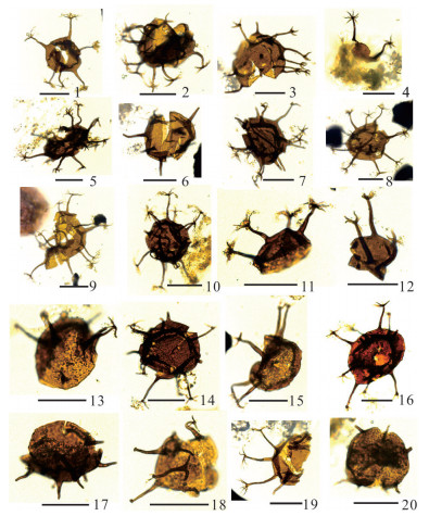
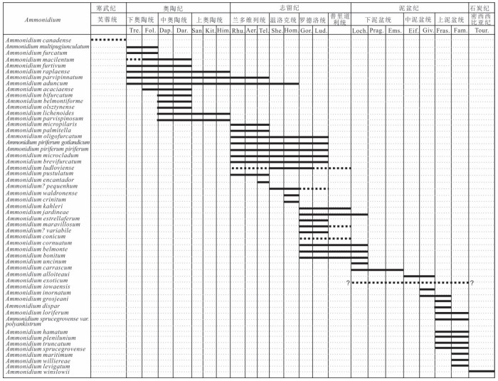
Many species that can be attributed to AmmonidiumLister, 1970 have been differently assigned to Multiplicisphaeridium Staplin, 1961 , Baltisphaeridium Eisenack, 1958 ex Eisenack, 1959 and other similar genera, which, to some extent, narrowed the original definition. The diagnosis of Ammonidium is emended here in based on reference comparison and some Ammonidium taxa collected recently from the lower part of the Hongguleleng Formation, NW Xinjiang. This paper considers Caiacorymbifer Tappan and Loeblich 1971 , Gracilisphaeridium Eisenack and Cramer 1973 , Naevisphaeridium Wicander 1974, Puteoscortum Wicander and Loeblich 1977 , Craterisphaeridium Deunff 1981, Pertusisphaeridium Turner 1986, and Martinsphaeridium Sarjeant and Vavrdová 1997 are junior synonyms of Ammonidium. The taxonomical ranks of Ammonidium sprucegrovense var. polyankistrum Wicander and Loeblich, 1977 are changed from the species to the varietas level. A new species is proposed, i.e., Ammonidium levigatum n. sp., which may have been erroneously identified as A.loriferum (Deunff) Hashemi and Playford 1998 or A. sprucegrovense(Staplin) Lister 1970 in many publications.Ammonidium levigatum n. sp. is widely distributed in the margins ofpalaeocontinents and is an important stratigraphical index fossil for the Late Devonian.
Many species that can be attributed to Ammonidium


2022, 47(8): 3005-3015.
doi: 10.3799/dqkx.2021.202
Abstract:
In this study, two sediment core samples were collected from the tubeworms area (site ROV06) and mussel area (site HM101) of the Haima cold seep, northern South China Sea. We extracted the lipid biomarkers, analyzed the contents and stable carbon isotopic values to study the source of the organic matter in seabed surface sediments, the distribution of microbial communities and their response to the seep leakage intensity. Alarge amount of crocetane, PMI, archaeol and sn2⁃hydroxyarchaeol (sn2⁃OH⁃Ar) related to anaerobic methanotrophic archaea (ANME) and iso⁃C15 and ai⁃C15 fatty acids produced by sulfate⁃reducing bacteria (SRB) were detected. The extremely negative δ13C values of these lipid biomarkers (as low as -126‰ for archaea biomarkers and -89 ‰ for sulfate⁃reducing bacteria biomarkers) indicated that anaerobic oxidation methane (AOM) occurred in the sediments. Crocetane was detected in the sediments of both ROV06 and HM101 sites, and most of the ratio of sn2⁃OH⁃Ar/archaeol was higher than 1, while the ratio of ai⁃C15/iso⁃C15fattyacid was lower than 2, indicating dominated community of ANME⁃2/DSS consortium in both site and a strong methane leakage intensity. The surface sediment of ROV06 site contained crocetane, whereas the low ratio of sn2⁃OH⁃Ar/archaeol(less than 1) and high ratio of ai⁃C15/iso⁃C15 fatty acid (> 2.1) indicated a mixed communities of ANME⁃1 /DSS and ANME⁃2 /DSS and the methane leakage intensity from bottom to surface of ROV06 station with a decreasing trend. The δ13C values of methane (-58‰~-53‰) were calculated based on the carbon isotopic fraction (Δ: -50‰) of ANME⁃2 and the mean δ13C values of the archaea biomarkers (PMI, archaeol, sn2⁃OH⁃Ar), indicating a mixture of thermogenic and biogenic source of methane. Methane at ROV06 and HM101 sites showed similar δ13C values, whereas the δ13C values of the biomarkers derived from SRB at ROV06 was lower than that at HM101 (Δδ13C: 18‰), which may be related to the absorption of sulfide and the release of sulfates by sulfur⁃oxidizing bacteria, a symbiotic bacterium of the tubeworms. The continuous release of sulfates was likely to greatly enhance AOM progress, resulting in more 13C⁃depleted inorganic carbon in the sediment.
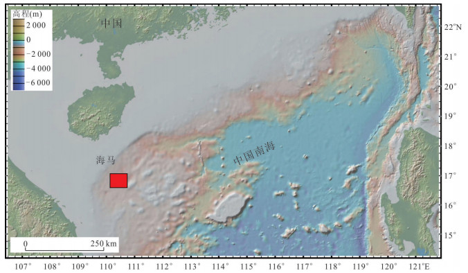
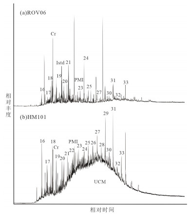
In this study, two sediment core samples were collected from the tubeworms area (site ROV06) and mussel area (site HM101) of the Haima cold seep, northern South China Sea. We extracted the lipid biomarkers, analyzed the contents and stable carbon isotopic values to study the source of the organic matter in seabed surface sediments, the distribution of microbial communities and their response to the seep leakage intensity. Alarge amount of crocetane, PMI, archaeol and sn2⁃hydroxyarchaeol (sn2⁃OH⁃Ar) related to anaerobic methanotrophic archaea (ANME) and iso⁃C15 and ai⁃C15 fatty acids produced by sulfate⁃reducing bacteria (SRB) were detected. The extremely negative δ13C values of these lipid biomarkers (as low as -126‰ for archaea biomarkers and -89 ‰ for sulfate⁃reducing bacteria biomarkers) indicated that anaerobic oxidation methane (AOM) occurred in the sediments. Crocetane was detected in the sediments of both ROV06 and HM101 sites, and most of the ratio of sn2⁃OH⁃Ar/archaeol was higher than 1, while the ratio of ai⁃C15/iso⁃C15fattyacid was lower than 2, indicating dominated community of ANME⁃2/DSS consortium in both site and a strong methane leakage intensity. The surface sediment of ROV06 site contained crocetane, whereas the low ratio of sn2⁃OH⁃Ar/archaeol(less than 1) and high ratio of ai⁃C15/iso⁃C15 fatty acid (> 2.1) indicated a mixed communities of ANME⁃1 /DSS and ANME⁃2 /DSS and the methane leakage intensity from bottom to surface of ROV06 station with a decreasing trend. The δ13C values of methane (-58‰~-53‰) were calculated based on the carbon isotopic fraction (Δ: -50‰) of ANME⁃2 and the mean δ13C values of the archaea biomarkers (PMI, archaeol, sn2⁃OH⁃Ar), indicating a mixture of thermogenic and biogenic source of methane. Methane at ROV06 and HM101 sites showed similar δ13C values, whereas the δ13C values of the biomarkers derived from SRB at ROV06 was lower than that at HM101 (Δδ13C: 18‰), which may be related to the absorption of sulfide and the release of sulfates by sulfur⁃oxidizing bacteria, a symbiotic bacterium of the tubeworms. The continuous release of sulfates was likely to greatly enhance AOM progress, resulting in more 13C⁃depleted inorganic carbon in the sediment.


2022, 47(8): 3016-3028.
doi: 10.3799/dqkx.2021.146
Abstract:
The Central Yunnan Terrane, with internal faults developed, is located in the Southeast of the Tibetan Plateau, which is an ideal place to study the Cenozoic tectonic deformation mechanism of this area. The Cenozoic deformation mechanism of the Central Yunnan Terrane is controversial, and there are two main types of deformation mechanism: "lower crustal flow" and the "rigid block extrusion". The former proposed that the tectonic activity of the block is more uniform, and the latter proposed that the tectonic activity is more intense along the fault. The tectonic activity of different mechanisms has different responses on the surface, and the geomorphic index is extremely sensitive to the tectonic activity response. To determine the tectonic deformation mechanism of the Cenozoic in this study area, 319 basins (sub⁃basins) were extracted based on the SRTM⁃3 Digital Elevation Model (DEM) with a resolution of 30 m. Indices used include hypsometric curve and hypsometric integral (HI), drainage basin shape (BS), asymmetric factor (AF), normalized stream⁃length gradient (SLK), and the ratio of valley floor width to valley height (VF). Results from the analysis are accumulated and expressed as an index of relative active tectonics (Iat), which we divide into four classes from relatively low to highest tectonic activity. The results are: The Iat values of the Lijiang⁃Xiaojinhe fault zone, Zemuhe⁃Xiaojiang fault zone, and Red River fault zone in the Central Yunnan are relatively small, and they gradually increase from north to south, which is consistent with the "rigid block extrusion" mode. At the same time, the Iat value on both sides of the Jinsha River is relatively low it shows that the geomorphic activity is strong, which may be due to the uplift of the Central Yunnan block and river system reconstitution, and the resulting knick points are transmitted upstream. During the migration of the cracks, they are transmitted from the main river channel to the secondary river channel, which affects the increase of the HI, BS and SLK value and the decrease of the VF value, making the relative tectonic activity stronger.
The Central Yunnan Terrane, with internal faults developed, is located in the Southeast of the Tibetan Plateau, which is an ideal place to study the Cenozoic tectonic deformation mechanism of this area. The Cenozoic deformation mechanism of the Central Yunnan Terrane is controversial, and there are two main types of deformation mechanism: "lower crustal flow" and the "rigid block extrusion". The former proposed that the tectonic activity of the block is more uniform, and the latter proposed that the tectonic activity is more intense along the fault. The tectonic activity of different mechanisms has different responses on the surface, and the geomorphic index is extremely sensitive to the tectonic activity response. To determine the tectonic deformation mechanism of the Cenozoic in this study area, 319 basins (sub⁃basins) were extracted based on the SRTM⁃3 Digital Elevation Model (DEM) with a resolution of 30 m. Indices used include hypsometric curve and hypsometric integral (HI), drainage basin shape (BS), asymmetric factor (AF), normalized stream⁃length gradient (SLK), and the ratio of valley floor width to valley height (VF). Results from the analysis are accumulated and expressed as an index of relative active tectonics (Iat), which we divide into four classes from relatively low to highest tectonic activity. The results are: The Iat values of the Lijiang⁃Xiaojinhe fault zone, Zemuhe⁃Xiaojiang fault zone, and Red River fault zone in the Central Yunnan are relatively small, and they gradually increase from north to south, which is consistent with the "rigid block extrusion" mode. At the same time, the Iat value on both sides of the Jinsha River is relatively low it shows that the geomorphic activity is strong, which may be due to the uplift of the Central Yunnan block and river system reconstitution, and the resulting knick points are transmitted upstream. During the migration of the cracks, they are transmitted from the main river channel to the secondary river channel, which affects the increase of the HI, BS and SLK value and the decrease of the VF value, making the relative tectonic activity stronger.


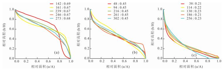
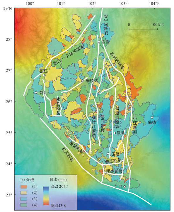


2022, 47(8): 3029-3044.
doi: 10.3799/dqkx.2022.086
Abstract:
The Zhongba rift zone located on the west side of the southern Tibet rift system has well⁃developed faults and clear faulted landforms. However, the study on the activity of the fault is still lacking, which hinders our understanding of the deformation mechanism of the entire southern Tibet rift system. Based on GIS spatial analysis technology, we used the Digital Elevation Model data system to extract geomorphic parameters in this area, including topographic slope, topographic relief, channel steepness index, and knickpoints. We analyzed 36 basins on both sides of the Zhongba rift. The results show that the topographic slope is consistent with ksn. On the west side of the Zhongba rift, tributaries located on the north and middle sections have steeper slopes and higher ksn; tributaries in the south have steeper middle section with higher ksn value. On the east side, the slope and ksn are steep at the middle part and gentle at both ends. The river profiles display that the channel steepness are different on both sides of the knickpoints. The rivers of the east and west sides have the highest channel steepness near the outlets, and decrease towards the upstream. Generally, the river channels on the west sides are steeper than ones on the east side. Based on the analysis results of the topographical slope, river profiles, and knickpoints, we suspect that the tectonic activity of the faults on the west side of the Zhongba rift may be stronger than that on the east side.
The Zhongba rift zone located on the west side of the southern Tibet rift system has well⁃developed faults and clear faulted landforms. However, the study on the activity of the fault is still lacking, which hinders our understanding of the deformation mechanism of the entire southern Tibet rift system. Based on GIS spatial analysis technology, we used the Digital Elevation Model data system to extract geomorphic parameters in this area, including topographic slope, topographic relief, channel steepness index, and knickpoints. We analyzed 36 basins on both sides of the Zhongba rift. The results show that the topographic slope is consistent with ksn. On the west side of the Zhongba rift, tributaries located on the north and middle sections have steeper slopes and higher ksn; tributaries in the south have steeper middle section with higher ksn value. On the east side, the slope and ksn are steep at the middle part and gentle at both ends. The river profiles display that the channel steepness are different on both sides of the knickpoints. The rivers of the east and west sides have the highest channel steepness near the outlets, and decrease towards the upstream. Generally, the river channels on the west sides are steeper than ones on the east side. Based on the analysis results of the topographical slope, river profiles, and knickpoints, we suspect that the tectonic activity of the faults on the west side of the Zhongba rift may be stronger than that on the east side.
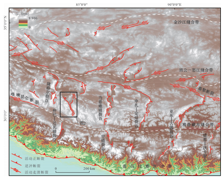


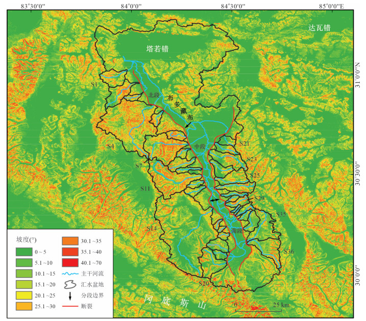


2022, 47(8): 3045-3055.
doi: 10.3799/dqkx.2022.208
Abstract:
Spontaneous imbibition exists in many key stages such as volume fracturing and water injection development in shale reservoirs, which is one of the important factors affecting shale oil productivity. Clarifying the characteristics of imbibition and influencing factors is of great significance to improve the recovery of shale oil. In this paper, spontaneous imbibition experiments were carried out on shale oil reservoirs samples with different source⁃reservoir configuration relationships in Chang 7 member of Ordos Basin. Combined with NMR technology, fluid migration process was monitored, and the influence mechanism of reservoir physical properties and pore structure on spontaneous imbibition of shale oil reservoirs was analyzed, so as to clarify the control effect of source⁃reservoir configuration relationship on imbibition. The average volume fraction of source-type imbibition in Chang 7 member is 33.84 %, and the source-reservoir interbed type is 25.98 %. The average slope of the source⁃type suction stage is 0.359, and the average of the source⁃reservoir interlayer type is 0.302. The proportion of pores with NMR transverse relaxation time less than 10 ms in the imbibition process is high; imbibition volume fraction has good correlation with wettability, reservoir quality factor and pore throat ratio. The permeability of source⁃source configuration relationship of Chang 7 shale oil reservoir is better than that of source⁃reservoir interbed; reservoir imbibition capacity is mainly controlled by wettability, reservoir quality factor and pore throat ratio.
Spontaneous imbibition exists in many key stages such as volume fracturing and water injection development in shale reservoirs, which is one of the important factors affecting shale oil productivity. Clarifying the characteristics of imbibition and influencing factors is of great significance to improve the recovery of shale oil. In this paper, spontaneous imbibition experiments were carried out on shale oil reservoirs samples with different source⁃reservoir configuration relationships in Chang 7 member of Ordos Basin. Combined with NMR technology, fluid migration process was monitored, and the influence mechanism of reservoir physical properties and pore structure on spontaneous imbibition of shale oil reservoirs was analyzed, so as to clarify the control effect of source⁃reservoir configuration relationship on imbibition. The average volume fraction of source-type imbibition in Chang 7 member is 33.84 %, and the source-reservoir interbed type is 25.98 %. The average slope of the source⁃type suction stage is 0.359, and the average of the source⁃reservoir interlayer type is 0.302. The proportion of pores with NMR transverse relaxation time less than 10 ms in the imbibition process is high; imbibition volume fraction has good correlation with wettability, reservoir quality factor and pore throat ratio. The permeability of source⁃source configuration relationship of Chang 7 shale oil reservoir is better than that of source⁃reservoir interbed; reservoir imbibition capacity is mainly controlled by wettability, reservoir quality factor and pore throat ratio.
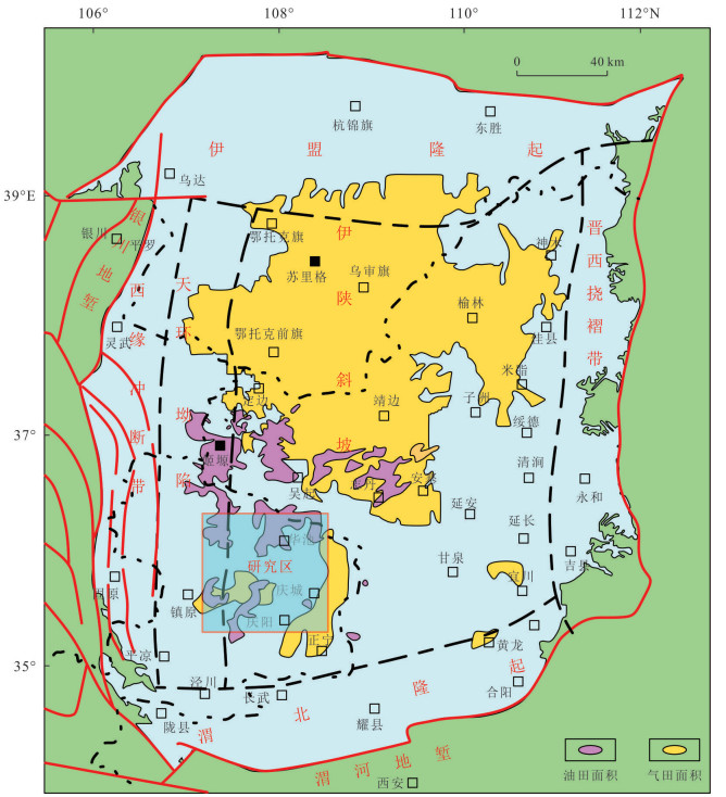
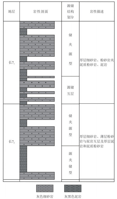
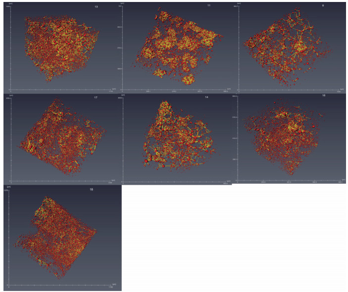
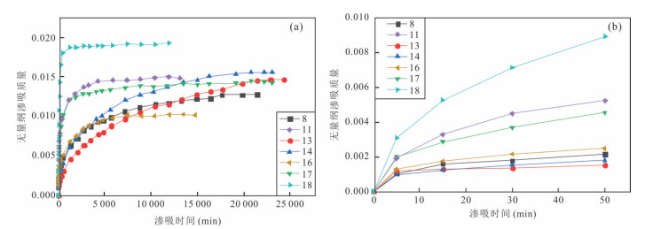
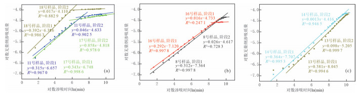
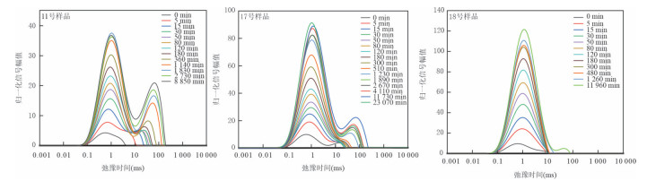


2022, 47(8): 3056-3072.
doi: 10.3799/dqkx.2021.236
Abstract:
Jurassic volcanic rocks of the Tamulangou Formation show great potential for oil and gas exploration, but it is not clear that the volcanic eruption cycles and paleogeography of the Tamulangou Formation, which restricts the exploration for volcanic reservoirs in the basin. Considering the complicated volcanic facies that are often fast changed and various volcanic edifices, this paper comprehensively analyzes outcrop investigation, volcanic U⁃Pb geochronology, drilling and logging, and seismic data, and uses the technology of seismic reflection features, time slice, three⁃dimensional visualization and Mean Square Root Amplitude property to identify volcano⁃sedimentary series, volcanic eruption cycles and lithological paleogeography of each sag in Hailaer Basin. These lines of evidence suggest that Jurassic rocks in Hailaer Basin developed two sets of volcanic⁃sedimentary cycles. Sedimentary beds that deposited outside volcanic edifices during the intermittent period of volcanic eruptions are used as mark beds to regionally recognize eruption cycles due to the continuous reflections formed on the corresponding seismic profile. The Mean Square Root Amplitude that is sensitive to lithology is used to outline volcanic edifices and their surrounding sedimentary beds. The first volcanic⁃sedimentary cycle is characterized by mafic to acidic volcanic rocks and sedimentary intervals that correspond to the Tamulangou Formation outside of the basin. The second volcanic⁃sedimentary cycle is characterized by acidic volcanic rocks and sedimentary intervals, corresponding to the Manitu Formation outside of the basin. The western depression zone mainly develops volcanic edifices and volcanic⁃sedimentary aprons at the edges of the volcanic edifices. The central and eastern depression zones mainly develop lacustrine sandstone and mudstone. The volcanic edifices inside sags are mainly concentrated in the basin floor or slope zone. The Jurassic volcanic⁃sedimentary rocks in the Hailar Basin shows typical characteristics of fault⁃control lake basins, and the Erguna and Deerbugan fault zones in the region greatly influence the distribution of volcanic⁃sedimentary rocks.
Jurassic volcanic rocks of the Tamulangou Formation show great potential for oil and gas exploration, but it is not clear that the volcanic eruption cycles and paleogeography of the Tamulangou Formation, which restricts the exploration for volcanic reservoirs in the basin. Considering the complicated volcanic facies that are often fast changed and various volcanic edifices, this paper comprehensively analyzes outcrop investigation, volcanic U⁃Pb geochronology, drilling and logging, and seismic data, and uses the technology of seismic reflection features, time slice, three⁃dimensional visualization and Mean Square Root Amplitude property to identify volcano⁃sedimentary series, volcanic eruption cycles and lithological paleogeography of each sag in Hailaer Basin. These lines of evidence suggest that Jurassic rocks in Hailaer Basin developed two sets of volcanic⁃sedimentary cycles. Sedimentary beds that deposited outside volcanic edifices during the intermittent period of volcanic eruptions are used as mark beds to regionally recognize eruption cycles due to the continuous reflections formed on the corresponding seismic profile. The Mean Square Root Amplitude that is sensitive to lithology is used to outline volcanic edifices and their surrounding sedimentary beds. The first volcanic⁃sedimentary cycle is characterized by mafic to acidic volcanic rocks and sedimentary intervals that correspond to the Tamulangou Formation outside of the basin. The second volcanic⁃sedimentary cycle is characterized by acidic volcanic rocks and sedimentary intervals, corresponding to the Manitu Formation outside of the basin. The western depression zone mainly develops volcanic edifices and volcanic⁃sedimentary aprons at the edges of the volcanic edifices. The central and eastern depression zones mainly develop lacustrine sandstone and mudstone. The volcanic edifices inside sags are mainly concentrated in the basin floor or slope zone. The Jurassic volcanic⁃sedimentary rocks in the Hailar Basin shows typical characteristics of fault⁃control lake basins, and the Erguna and Deerbugan fault zones in the region greatly influence the distribution of volcanic⁃sedimentary rocks.