


2023 Vol. 48, No. 1
Display Method:
2023, 48(1): 1-13.
doi: 10.3799/dqkx.2022.311
 PDF 7294KB
Abstract:
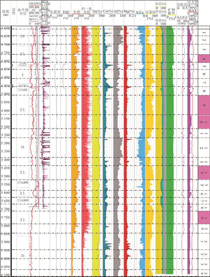
According to the geological characteristics of deep shale gas, such as large horizontal stress difference, small vertical stress difference and strong rock plastic characteristics, evaluation methods were established for the logging curve, total organic carbon, porosity, all gas hydrocarbon, key logging elements, silicon, mineral brittleness, rock mechanics parameters, etc.. And the geology-engineering double sweet spot study along the horizontal wellbore was carried out based on the design concept of geology-engineering integration, so as to accurately identify optimal geological & engineering sweet spot, providing guidance for horizontal well fracturing in deep shale gas play. Then, based on three-dimensional fracture network with high fracture conductivity as the objective function, the volume fracturing pump mode and key parameter optimizations were studied for deep shale gas well under narrow pressure window, i.e., circuitous temporary plugging fracturing technology optimization, the dynamic movement of proppant in complex fracture network and test of fracture conductivity, and research and development for integrated variable viscosity slick water, etc.. Field applications demonstrate that the geology-engineering integration volumetric fracturing technology could improve post-frac gas production by more than 30%-50% compared with adjacent wells. The technology can greatly improve the economic development of deep shale gas wells, and it also has important guiding significance for shale gas wells with vertical depth more than 4 500 m as well.
According to the geological characteristics of deep shale gas, such as large horizontal stress difference, small vertical stress difference and strong rock plastic characteristics, evaluation methods were established for the logging curve, total organic carbon, porosity, all gas hydrocarbon, key logging elements, silicon, mineral brittleness, rock mechanics parameters, etc.. And the geology-engineering double sweet spot study along the horizontal wellbore was carried out based on the design concept of geology-engineering integration, so as to accurately identify optimal geological & engineering sweet spot, providing guidance for horizontal well fracturing in deep shale gas play. Then, based on three-dimensional fracture network with high fracture conductivity as the objective function, the volume fracturing pump mode and key parameter optimizations were studied for deep shale gas well under narrow pressure window, i.e., circuitous temporary plugging fracturing technology optimization, the dynamic movement of proppant in complex fracture network and test of fracture conductivity, and research and development for integrated variable viscosity slick water, etc.. Field applications demonstrate that the geology-engineering integration volumetric fracturing technology could improve post-frac gas production by more than 30%-50% compared with adjacent wells. The technology can greatly improve the economic development of deep shale gas wells, and it also has important guiding significance for shale gas wells with vertical depth more than 4 500 m as well.


2023, 48(1): 14-29.
doi: 10.3799/dqkx.2022.493
Abstract:
A series of exploration and development breakthroughs for continental shale oil have been achieved in recent years in China. However, there are great challenges to the risk resistance capability and sustainable ability of large-scale development. The reformation of cognition and mentality is critical to achieve large-scale economic development. A constructive view is proposed that the goal is to achieve reasonable economic returns with maximized recovery and minimized environmental impacts in the lifecycle of an asset project. Adhering to this idea, it is emphasized that the fluid transfer capability, reservoir stimulation potential and oil recovery enhancement potential of continental shale oil with associated key contents must be systematically evaluated. Some important factors are reviewed and discussed in depth such as fluid heterogeneities, micro wettability, macro molecular retention, meso-to-macro geomechanical characteristics, mechanism of proactive utilization of stress interference, and so on, which had been paid insufficient attentions previously. It is concluded that fluid transfer capability is the basis of sweet-spot evaluation and enhanced oil recovery. The cumulative effect formed by the coupling evolution process of shale oil in geologic time plays a key role at present. The multi-scale mechanical properties of shale with complex fabrics and the dynamic evolution behavior of induced stress field are key factors for reservoir stimulation potential. The effectiveness of an artificial reservoir can be significantly improved through proactive utilization of stress interference. The oil mobility in nano pores is the core of micro displacement efficiency. Unique recovery mechanisms with the artificial reservoir can be promoted and utilized through stereoscopic development. The fundamental evaluation properties can at least include fluid heterogeneity, micro wettability, mesoscopic geomechanics and the effective matrix permeability of stimulated reservoir volume. It is vital to have proper characterization and theoretical models for them. It is suggested that development of innovative lab equipment and approaches, establishment of on-site scientific laboratory for continental shale oil, research of digital and intelligent emulation technology and associated evaluation methods, and construction of multi-scale mapping and modeling technology based on "digital twins".
A series of exploration and development breakthroughs for continental shale oil have been achieved in recent years in China. However, there are great challenges to the risk resistance capability and sustainable ability of large-scale development. The reformation of cognition and mentality is critical to achieve large-scale economic development. A constructive view is proposed that the goal is to achieve reasonable economic returns with maximized recovery and minimized environmental impacts in the lifecycle of an asset project. Adhering to this idea, it is emphasized that the fluid transfer capability, reservoir stimulation potential and oil recovery enhancement potential of continental shale oil with associated key contents must be systematically evaluated. Some important factors are reviewed and discussed in depth such as fluid heterogeneities, micro wettability, macro molecular retention, meso-to-macro geomechanical characteristics, mechanism of proactive utilization of stress interference, and so on, which had been paid insufficient attentions previously. It is concluded that fluid transfer capability is the basis of sweet-spot evaluation and enhanced oil recovery. The cumulative effect formed by the coupling evolution process of shale oil in geologic time plays a key role at present. The multi-scale mechanical properties of shale with complex fabrics and the dynamic evolution behavior of induced stress field are key factors for reservoir stimulation potential. The effectiveness of an artificial reservoir can be significantly improved through proactive utilization of stress interference. The oil mobility in nano pores is the core of micro displacement efficiency. Unique recovery mechanisms with the artificial reservoir can be promoted and utilized through stereoscopic development. The fundamental evaluation properties can at least include fluid heterogeneity, micro wettability, mesoscopic geomechanics and the effective matrix permeability of stimulated reservoir volume. It is vital to have proper characterization and theoretical models for them. It is suggested that development of innovative lab equipment and approaches, establishment of on-site scientific laboratory for continental shale oil, research of digital and intelligent emulation technology and associated evaluation methods, and construction of multi-scale mapping and modeling technology based on "digital twins".


2023, 48(1): 30-48.
doi: 10.3799/dqkx.2022.183
Abstract:
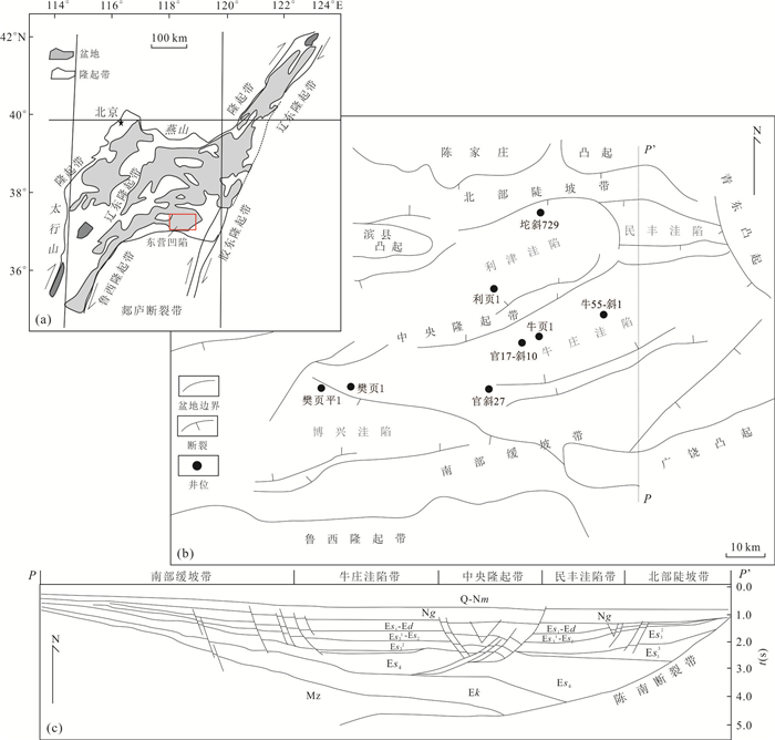
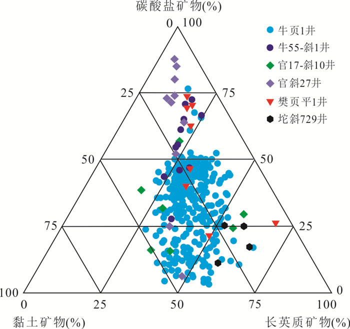
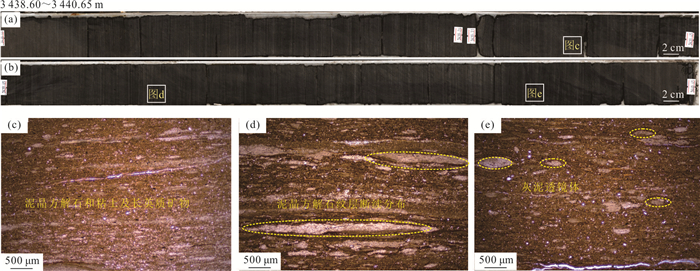
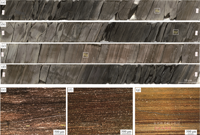
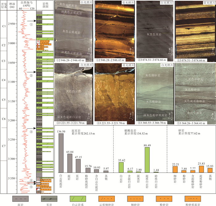
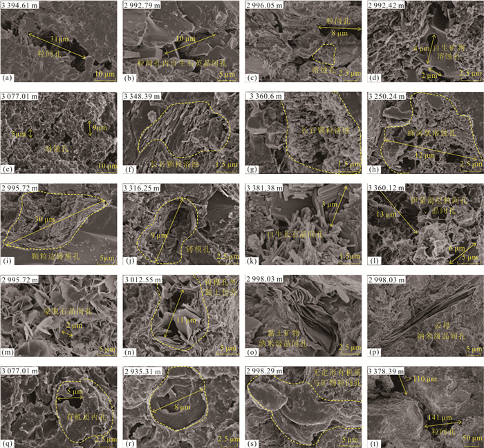
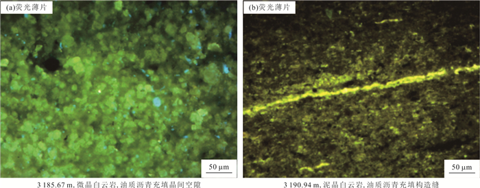
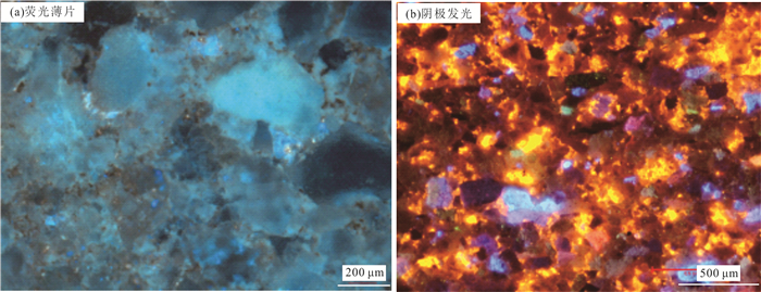
There are no relevant research results and technical methods on the classification of shale lithofacies combinations in continental faulted basins, and the basic characteristics of different shale lithofacies assemblages need to be further clarified. Based on the fine observation and description of the core samples, the basic rock and lithofacies types of the sampled shale sections were identified by observing rock thin sections and performing X-ray-based full-rock mineral diffraction analysis. By analyzing the major mineral composition and major and trace element contents of the samples, information about the sedimentary paleoenvironment of the Jiyang Depression was extracted. According to the basic characteristics of the four paleoenvironment factors (paleoclimate, paleosource, paleosalinity, paleowater depth), the shale stratigraphy of the Upper Sub-member of the Fourth Member of Shahejie Formation (Es4s) in the Dongying Sag was divided into lithofacies combinations based on the principle of sedimentary environment similarity and internal structure uniformity. A lithofacies combination classification scheme based on sedimentary environment control was established, and combined with reservoir and organic geochemical analysis, the main lithofacies combination reservoir and oil-bearing characteristics were clarified. Results show that: (1) Es4s shale in the Dongying Sag is a typical carbonate-rich shale (carbonate shale) and mixed shale, with significant lamination features, various types of pores, well-developed bedding and structural fractures, high organic matter abundance, moderate-to-low evolutionary degree, deep burial depth and high pressure coefficient. (2) Based on sedimentary structural position and paleoenvironment, the Es4s shale in the Dongying Sag can be divided into 8 lithofacies combinations. In the central part of the basin, the matrix carbonate shale lithofacies combination is dominant, with some interbedded block dolomite shale lithofacies combination. In the northern steep slope belt, the sandstone interbedded shale lithofacies combination is mainly developed, and in the southern gentle slope belt, the block dolomite shale interbedded lithofacies combination and the laminar carbonate mudstone and dolomite shale interbedded lithofacies combination are mainly developed. (3) In general, as the main body of fine-grained sediments, the Es4s matrix shale stratigraphy in the center of the Dongying Sag develops from bottom to top: laminar carbonate shale interbedded with block dolomite shale lithofacies, laminar carbonate shale and dolomite shale interbedded lithofacies, laminar carbonate shale and carbonate mudstone interbedded lithofacies, laminar carbonate shale interbedded with carbonate mudstone lithofacies, laminated carbonate shale and carbonate mudstone interbedded lithofacies, laminated carbonate shale interbedded with carbonate mudstone lithofacies, etc., revealing the change in sedimentary paleoenvironment from arid, brackish water, semi-deep water, and less source rocks to semi-wet, semi-brackish water, deep water, and more source rocks. (4) The laminar carbonate shale interbedded with carbonate mudstone lithofacies combination and the laminar carbonate shale and carbonate mudstone interbedded lithofacies combination are the most developed, with a variety of reservoir space types, high proportion of large-diameter pores and good connectivity. The laminar carbonate shale and carbonate mudstone interbedded lithofacies combination has relatively high oil saturation, and is also a favorable lithofacies combination type for achieving breakthroughs in shale oil in the Jiyang Depression. The laminar carbonate shale interbedded with block-type dolomite shale lithofacies combination has good oil-bearing and brittle properties. Further analysis of the basic geological characteristics and oil-bearing characteristics of different lithofacies combinations and determination of the development and distribution characteristics of the main shale lithofacies combinations are of practical significance for exploring shale oil in continental faulted basins.
There are no relevant research results and technical methods on the classification of shale lithofacies combinations in continental faulted basins, and the basic characteristics of different shale lithofacies assemblages need to be further clarified. Based on the fine observation and description of the core samples, the basic rock and lithofacies types of the sampled shale sections were identified by observing rock thin sections and performing X-ray-based full-rock mineral diffraction analysis. By analyzing the major mineral composition and major and trace element contents of the samples, information about the sedimentary paleoenvironment of the Jiyang Depression was extracted. According to the basic characteristics of the four paleoenvironment factors (paleoclimate, paleosource, paleosalinity, paleowater depth), the shale stratigraphy of the Upper Sub-member of the Fourth Member of Shahejie Formation (Es4s) in the Dongying Sag was divided into lithofacies combinations based on the principle of sedimentary environment similarity and internal structure uniformity. A lithofacies combination classification scheme based on sedimentary environment control was established, and combined with reservoir and organic geochemical analysis, the main lithofacies combination reservoir and oil-bearing characteristics were clarified. Results show that: (1) Es4s shale in the Dongying Sag is a typical carbonate-rich shale (carbonate shale) and mixed shale, with significant lamination features, various types of pores, well-developed bedding and structural fractures, high organic matter abundance, moderate-to-low evolutionary degree, deep burial depth and high pressure coefficient. (2) Based on sedimentary structural position and paleoenvironment, the Es4s shale in the Dongying Sag can be divided into 8 lithofacies combinations. In the central part of the basin, the matrix carbonate shale lithofacies combination is dominant, with some interbedded block dolomite shale lithofacies combination. In the northern steep slope belt, the sandstone interbedded shale lithofacies combination is mainly developed, and in the southern gentle slope belt, the block dolomite shale interbedded lithofacies combination and the laminar carbonate mudstone and dolomite shale interbedded lithofacies combination are mainly developed. (3) In general, as the main body of fine-grained sediments, the Es4s matrix shale stratigraphy in the center of the Dongying Sag develops from bottom to top: laminar carbonate shale interbedded with block dolomite shale lithofacies, laminar carbonate shale and dolomite shale interbedded lithofacies, laminar carbonate shale and carbonate mudstone interbedded lithofacies, laminar carbonate shale interbedded with carbonate mudstone lithofacies, laminated carbonate shale and carbonate mudstone interbedded lithofacies, laminated carbonate shale interbedded with carbonate mudstone lithofacies, etc., revealing the change in sedimentary paleoenvironment from arid, brackish water, semi-deep water, and less source rocks to semi-wet, semi-brackish water, deep water, and more source rocks. (4) The laminar carbonate shale interbedded with carbonate mudstone lithofacies combination and the laminar carbonate shale and carbonate mudstone interbedded lithofacies combination are the most developed, with a variety of reservoir space types, high proportion of large-diameter pores and good connectivity. The laminar carbonate shale and carbonate mudstone interbedded lithofacies combination has relatively high oil saturation, and is also a favorable lithofacies combination type for achieving breakthroughs in shale oil in the Jiyang Depression. The laminar carbonate shale interbedded with block-type dolomite shale lithofacies combination has good oil-bearing and brittle properties. Further analysis of the basic geological characteristics and oil-bearing characteristics of different lithofacies combinations and determination of the development and distribution characteristics of the main shale lithofacies combinations are of practical significance for exploring shale oil in continental faulted basins.


2023, 48(1): 49-62.
doi: 10.3799/dqkx.2022.320
Abstract:
The development of shale oil in Gulong Sag has achieved promising results. It is particularly important to summarize the geological conditions of Gulong shale oil enrichment for the next stage of exploration. In this paper, it aims to summarize the geological characteristics and exploration results of Gulong shale until now, raise the possible scientific and technological issues faced by production, and point out the direction of scientific research for further study. The shale of the first member of Qingshankou Formation in the north of the Songliao Basin is characterized by high organic matter content (TOC ranges in 2.0%-3.0%, with an average value of 2.7%), oil-prone organic type (mainly type Ⅰ kerogen, and the hydrocarbon generating material is mainly layered algae), high maturity (Ro ranges in 1.20%-1.67%) and high clay mineral content (more than 35%). Benefiting from the high ground temperature gradient, the organic matter of Qingshankou Formation in Gulong Sag is in high maturity stage, with light oil quality (ground density less than 0.8 g/cm3) and high gas oil ratio (more than 50 m3/m3), which shows the potential for large-scale development of high maturity shale oil. The unclear evaluation standards of Gulong shale oil, the uncertainty of single well EUR prediction and the lack of technology for large scale development are the main challenges for Gulong shale oil exploration and development. The breakthrough in the research on the unique mechanism of continental shale oil enrichment, such as the influence of clay minerals on the oil phase, the saturation of oil and water and the control of wettability on the permeability and replacement efficiency of fracturing fluid, will promote the rapid realization of the oil production target of the national development demonstration area, and is expected to expand the exploration and development achievements of Gulong shale oil on the basis of the development of light oil belt.
The development of shale oil in Gulong Sag has achieved promising results. It is particularly important to summarize the geological conditions of Gulong shale oil enrichment for the next stage of exploration. In this paper, it aims to summarize the geological characteristics and exploration results of Gulong shale until now, raise the possible scientific and technological issues faced by production, and point out the direction of scientific research for further study. The shale of the first member of Qingshankou Formation in the north of the Songliao Basin is characterized by high organic matter content (TOC ranges in 2.0%-3.0%, with an average value of 2.7%), oil-prone organic type (mainly type Ⅰ kerogen, and the hydrocarbon generating material is mainly layered algae), high maturity (Ro ranges in 1.20%-1.67%) and high clay mineral content (more than 35%). Benefiting from the high ground temperature gradient, the organic matter of Qingshankou Formation in Gulong Sag is in high maturity stage, with light oil quality (ground density less than 0.8 g/cm3) and high gas oil ratio (more than 50 m3/m3), which shows the potential for large-scale development of high maturity shale oil. The unclear evaluation standards of Gulong shale oil, the uncertainty of single well EUR prediction and the lack of technology for large scale development are the main challenges for Gulong shale oil exploration and development. The breakthrough in the research on the unique mechanism of continental shale oil enrichment, such as the influence of clay minerals on the oil phase, the saturation of oil and water and the control of wettability on the permeability and replacement efficiency of fracturing fluid, will promote the rapid realization of the oil production target of the national development demonstration area, and is expected to expand the exploration and development achievements of Gulong shale oil on the basis of the development of light oil belt.


2023, 48(1): 63-76.
doi: 10.3799/dqkx.2022.212
Abstract:
In order to further clarify the dominant reservoir lithology of lacustrine shale strata, focus on sweet spots, improve the drilling encounter rate of sweet spots in the horizontal section, and increase the shale oil production of horizontal wells, this paper comprehensively uses the 494.29 m core of Well G108-8 in the second member of Kongdong Sag, more than 3 000 sub-sections, scanning electron microscopy, nuclear magnetic resonance, mercury intrusion and whole-rock X-ray analysis data to systematically analyze the carbonate rock, sandstone and shale pore types, structures, and heterogeneity. The results show that feldspar, quartz and organic matter have a constructive role in the development of reservoirs. Calcite, clay and analcite minerals are unfavorable factors for the development of reservoir space. Although dolomitization has improved carbon to a certain extent, dolomite-like microcrystalline, micrite nano-scale intercrystalline pore storage and poor seepage conditions, the dominant reservoir lithology of shale oil mainly includes feldspar lithic sandstone, laminar type shale and fractured dolomite. Laminar shale has various types of reservoir space, and the residual intergranular pores and dissolution pores in the laminae rich in felsic minerals have good connectivity. Artificial fractures form complex fracture network structure with the matrix pores and fractures, and has the ability to stabilize production, which is the main production layer of shale oil in the second member of the hole. The newly implemented horizontal well focuses the drilling box to the 8-10 m thick layered felsic shale interval, wells GY5-3-1L and GY5-1-9H produced more than 1.0×10⁴ t of oil per well in the first year, and the cost per barrel of oil dropped to US $65, realizing the profitable development of lacustrine shale oil.
In order to further clarify the dominant reservoir lithology of lacustrine shale strata, focus on sweet spots, improve the drilling encounter rate of sweet spots in the horizontal section, and increase the shale oil production of horizontal wells, this paper comprehensively uses the 494.29 m core of Well G108-8 in the second member of Kongdong Sag, more than 3 000 sub-sections, scanning electron microscopy, nuclear magnetic resonance, mercury intrusion and whole-rock X-ray analysis data to systematically analyze the carbonate rock, sandstone and shale pore types, structures, and heterogeneity. The results show that feldspar, quartz and organic matter have a constructive role in the development of reservoirs. Calcite, clay and analcite minerals are unfavorable factors for the development of reservoir space. Although dolomitization has improved carbon to a certain extent, dolomite-like microcrystalline, micrite nano-scale intercrystalline pore storage and poor seepage conditions, the dominant reservoir lithology of shale oil mainly includes feldspar lithic sandstone, laminar type shale and fractured dolomite. Laminar shale has various types of reservoir space, and the residual intergranular pores and dissolution pores in the laminae rich in felsic minerals have good connectivity. Artificial fractures form complex fracture network structure with the matrix pores and fractures, and has the ability to stabilize production, which is the main production layer of shale oil in the second member of the hole. The newly implemented horizontal well focuses the drilling box to the 8-10 m thick layered felsic shale interval, wells GY5-3-1L and GY5-1-9H produced more than 1.0×10⁴ t of oil per well in the first year, and the cost per barrel of oil dropped to US $65, realizing the profitable development of lacustrine shale oil.


2023, 48(1): 77-91.
doi: 10.3799/dqkx.2022.356
Abstract:
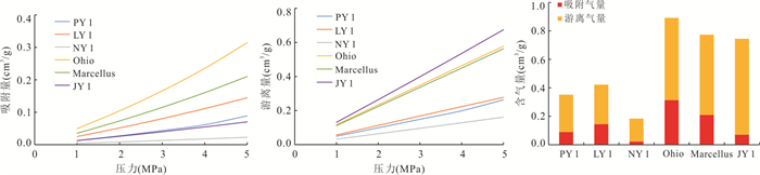
After continuous research in various countries, overpressured shale gas has been commercially developed in most countries, but normally-pressured shale gas has only been commercially developed in the United States. In order to overcome the current situation of China's high external dependence on natural gas, the commercial development of normally-pressured shale gas will play significant role to fulfill the demand in natural gas. It is urgent to study its enrichment characteristics, which may provide guidance for the formulation of development plans. This study starts from the tectonic & sedimentary evolution of typical normally-pressured shale gas reservoirs in the Lower Silurian shale of Sichuan Basin and Devonian shales of the Appalachian Basin. Then, the differences in reservoir geochemistry and shale gas occurrence characteristics are analyzed. Finally, the paper conducts the comparion analyses in the enrichment of normally-pressured shale gas reservoirs in China and the United States. Compared to the Appalachian Devonian Marcellus shale and Ohio shale with simple structural deformation, rich type Ⅱ-Ⅲ kerogen, high gas-bearing porosity and far away from outcrop, the Lower Silurian Wufeng-Longmaxi Formation shale layer in southeastern Sichuan is rich in high-mature type Ⅰ kerogen, and has undergone multiple stages of complex tectonic movement. This means that underlain formation is more structurally-deformed, the formation dip angle is larger, and the shale gas is easy to migrate to the underlain fractured rock and outcrop area to leak, so its gas content is slightly lower than that of Marcellus shale. But for the Ohio shale, even though which has low gas content and low enrichment, it is easier to reach industrial gas flow by depressurization due to its shallow burial and low temperature and pressure.
After continuous research in various countries, overpressured shale gas has been commercially developed in most countries, but normally-pressured shale gas has only been commercially developed in the United States. In order to overcome the current situation of China's high external dependence on natural gas, the commercial development of normally-pressured shale gas will play significant role to fulfill the demand in natural gas. It is urgent to study its enrichment characteristics, which may provide guidance for the formulation of development plans. This study starts from the tectonic & sedimentary evolution of typical normally-pressured shale gas reservoirs in the Lower Silurian shale of Sichuan Basin and Devonian shales of the Appalachian Basin. Then, the differences in reservoir geochemistry and shale gas occurrence characteristics are analyzed. Finally, the paper conducts the comparion analyses in the enrichment of normally-pressured shale gas reservoirs in China and the United States. Compared to the Appalachian Devonian Marcellus shale and Ohio shale with simple structural deformation, rich type Ⅱ-Ⅲ kerogen, high gas-bearing porosity and far away from outcrop, the Lower Silurian Wufeng-Longmaxi Formation shale layer in southeastern Sichuan is rich in high-mature type Ⅰ kerogen, and has undergone multiple stages of complex tectonic movement. This means that underlain formation is more structurally-deformed, the formation dip angle is larger, and the shale gas is easy to migrate to the underlain fractured rock and outcrop area to leak, so its gas content is slightly lower than that of Marcellus shale. But for the Ohio shale, even though which has low gas content and low enrichment, it is easier to reach industrial gas flow by depressurization due to its shallow burial and low temperature and pressure.


2023, 48(1): 92-109.
doi: 10.3799/dqkx.2022.020
Abstract:
Sweet spot is a relatively high production formation and region in shale gas reservoir. The reasonable prediction and evaluation of geological sweet spot, engineering sweet spot and comprehensive sweet spot is the key to economical and efficient development of shale gas field. To solve the problem of shale gas sweet spot evaluation based on multi-parameter, a new geology-engineering integration shale gas sweet spot evaluation method is introduced. Base on the high-resolution three-dimensional (3D) attributer models, analytic hierarchy process (AHP) is applied to combine the geological sweet spot evaluation indices and engineering sweet spot evaluation indices. Firstly, by integrating the previous researches, a shale gas sweet spot evaluation system is established for geological, engineering and comprehensive sweet spot evaluations. Secondly, the technical route of geology-engineering integration sweet spot evaluation method for shale gas reservoir based on AHP is designed. Lastly, data from X well region in Taiyang shale gas field of Zhaotong shale gas demonstration area are employed to verify the validity of proposed approach. Base on the high-resolution 3D models of the target area, the geological, engineering and comprehensive sweet spot has been evaluated by using the proposed approach. The results show that the proposed approach can realize the evaluation of geological, engineering and comprehensive sweet spot for the target area by integrating geological and engineering indices. The evaluation results show that sweet spot is mainly distributed in Ordovician Wufeng Formation (WF) and the first three layers of the first sub-formation of the first Silurian Longmaxi Formation (L111, L112 and L113). While, the sweet spot in the fourth layer of the first sub-formation of the first Silurian Longmaxi Formation (L114) is relatively rarely distributed. By combining the qualitative analysis and quantitative analysis, the proposed geology-engineering integration sweet spot evaluation approach for shale gas reservoir based on AHP provides a new route for the delineation of shale gas sweet spot. Meanwhile, the proposed route can improve the rationality and accuracy of shale gas sweet spot evaluation results to some extent.
Sweet spot is a relatively high production formation and region in shale gas reservoir. The reasonable prediction and evaluation of geological sweet spot, engineering sweet spot and comprehensive sweet spot is the key to economical and efficient development of shale gas field. To solve the problem of shale gas sweet spot evaluation based on multi-parameter, a new geology-engineering integration shale gas sweet spot evaluation method is introduced. Base on the high-resolution three-dimensional (3D) attributer models, analytic hierarchy process (AHP) is applied to combine the geological sweet spot evaluation indices and engineering sweet spot evaluation indices. Firstly, by integrating the previous researches, a shale gas sweet spot evaluation system is established for geological, engineering and comprehensive sweet spot evaluations. Secondly, the technical route of geology-engineering integration sweet spot evaluation method for shale gas reservoir based on AHP is designed. Lastly, data from X well region in Taiyang shale gas field of Zhaotong shale gas demonstration area are employed to verify the validity of proposed approach. Base on the high-resolution 3D models of the target area, the geological, engineering and comprehensive sweet spot has been evaluated by using the proposed approach. The results show that the proposed approach can realize the evaluation of geological, engineering and comprehensive sweet spot for the target area by integrating geological and engineering indices. The evaluation results show that sweet spot is mainly distributed in Ordovician Wufeng Formation (WF) and the first three layers of the first sub-formation of the first Silurian Longmaxi Formation (L111, L112 and L113). While, the sweet spot in the fourth layer of the first sub-formation of the first Silurian Longmaxi Formation (L114) is relatively rarely distributed. By combining the qualitative analysis and quantitative analysis, the proposed geology-engineering integration sweet spot evaluation approach for shale gas reservoir based on AHP provides a new route for the delineation of shale gas sweet spot. Meanwhile, the proposed route can improve the rationality and accuracy of shale gas sweet spot evaluation results to some extent.


2023, 48(1): 110-129.
doi: 10.3799/dqkx.2022.139
Abstract:
The geology-engineering integration of shale gas is necessary for analyzing and evaluating the key elements in efficient exploration and development of shale gas. This paper presents a study from the perspectives of sweet spot optimization, drilling, well completion engineering, and fracturing technology in Luzhou area, southern Sichuan. Combined with the geology-engineering integration, the coupling relationship is systematically analyzed between engineering and geological factors. The results show that the geological conditions of the Luzhou area are complex, and the direction of horizontal maximum principal stress is NWW-SEE. The development of fractures decreases from west to east. The effective matching well trajectory can improve the fracturing volume between the natural fracture direction and the maximum principal stress direction. When the angle between the good trajectory azimuth and the stress is greater than 60°, and the angle between the good trajectory azimuth and the main fracture direction is greater than 20°, the horizontal well fracturing effect is better. Through technical optimization such as encryption clustering, an increase of displacement, temporary plugging and steering, and an increase of sand strength, the volume of deep shale transformation and the effectiveness of the fracture network can be ensured. In summary, with the coupling analysis of engineering and geological factors, the technical research on the relationship between deep good trajectory and sweet spot prediction, the relationship between deep fracture volume transformation and in-situ stress, and the relationship between deep drilling and completion engineering and rock mechanics can effectively promote the dynamic operation of geological engineering integration, which can improve the maximum recoverable amount of single well and the maximum production of the block.
The geology-engineering integration of shale gas is necessary for analyzing and evaluating the key elements in efficient exploration and development of shale gas. This paper presents a study from the perspectives of sweet spot optimization, drilling, well completion engineering, and fracturing technology in Luzhou area, southern Sichuan. Combined with the geology-engineering integration, the coupling relationship is systematically analyzed between engineering and geological factors. The results show that the geological conditions of the Luzhou area are complex, and the direction of horizontal maximum principal stress is NWW-SEE. The development of fractures decreases from west to east. The effective matching well trajectory can improve the fracturing volume between the natural fracture direction and the maximum principal stress direction. When the angle between the good trajectory azimuth and the stress is greater than 60°, and the angle between the good trajectory azimuth and the main fracture direction is greater than 20°, the horizontal well fracturing effect is better. Through technical optimization such as encryption clustering, an increase of displacement, temporary plugging and steering, and an increase of sand strength, the volume of deep shale transformation and the effectiveness of the fracture network can be ensured. In summary, with the coupling analysis of engineering and geological factors, the technical research on the relationship between deep good trajectory and sweet spot prediction, the relationship between deep fracture volume transformation and in-situ stress, and the relationship between deep drilling and completion engineering and rock mechanics can effectively promote the dynamic operation of geological engineering integration, which can improve the maximum recoverable amount of single well and the maximum production of the block.


2023, 48(1): 130-142.
doi: 10.3799/dqkx.2022.181
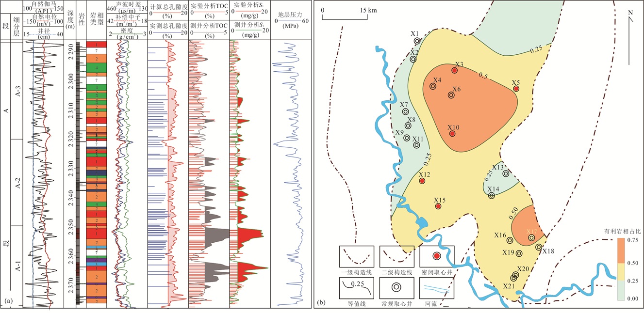
Abstract:
Shale lithofacies identification is an important task in the spatial distribution of shale oil and exploration target prediction, but it is difficult to identify lithofacies based on logging response equations due to the formation heterogeneity and redundancy of logging information. In this paper, a lithofacies identification model based on random forest algorithm is proposed, which uses the SHAP method to quantify the contribution of logging parameters. The results show that the random forest algorithm can identify shale lithofacies well, and its accuracy is higher than support vector machine, k-nearest neighbors and XGBoost; SP, CAL and AC contribute the most to the model's identification of lithofacies. The model can quickly identify the lithofacies of a single well, and determine the favorable lithofacies by combining total porosity, free hydrocarbon S1, TOC, etc., and then determine the distribution of favorable lithofacies in the whole area, providing a basis for subsequent "sweet spot" prediction.
Shale lithofacies identification is an important task in the spatial distribution of shale oil and exploration target prediction, but it is difficult to identify lithofacies based on logging response equations due to the formation heterogeneity and redundancy of logging information. In this paper, a lithofacies identification model based on random forest algorithm is proposed, which uses the SHAP method to quantify the contribution of logging parameters. The results show that the random forest algorithm can identify shale lithofacies well, and its accuracy is higher than support vector machine, k-nearest neighbors and XGBoost; SP, CAL and AC contribute the most to the model's identification of lithofacies. The model can quickly identify the lithofacies of a single well, and determine the favorable lithofacies by combining total porosity, free hydrocarbon S1, TOC, etc., and then determine the distribution of favorable lithofacies in the whole area, providing a basis for subsequent "sweet spot" prediction.


2023, 48(1): 143-157.
doi: 10.3799/dqkx.2022.444
Abstract:
The formation conditions of shale oil for the Lower Es3 (Third Member of Shahejie Formation) and Upper Es4 (Fourth Member of Shahejie Formation) Sub-member in Jiyang Depression, Bohai Bay Basin, are excellent, but none of the production test results of four evaluation wells and four system coring wells at preferred favorable layers reach the level of scale breakthrough. In order to reveal the causes of "failure" for the first round shale oil exploration wells in Jiyang Depression, the characteristics of oiliness, reservoir property, compressibility and mobility of shale oil for coring section of four system coring wells and the implementation of engineering technologies to preferred favorable layers of four system coring wells and four evaluation wells, are systematically analyzed. The results of this study show that the oiliness, reservoir property, compressibility and mobility of shale oil for coring section from wells NY1 and LY1 are all good and preferred favorable layers are reasonable, but the oiliness, reservoir property, and mobility of shale oil for coring section from wells FY1 and L69 are obviously lower than results of wells NY1 and LY1 and preferred favorable layers are incorrect. The main causes of "failure" for four evaluation wells are the maturity of shales rich in organic matter of horizontal intervals are low and the fracturing engineering technologies are poorly adaptable. The cause of "failure" for NY1 and LY1 of system coring wells at preferred favorable layer is mainly related to only conventional oil and gas test and production tools are used for joint measurement. The causes of "failure" for FY1 and L69 of system coring wells for preferred favorable layer are not only the preferred favorable layers are wrong, but also only conventional oil and gas test and production tools are used for joint measurement.
The formation conditions of shale oil for the Lower Es3 (Third Member of Shahejie Formation) and Upper Es4 (Fourth Member of Shahejie Formation) Sub-member in Jiyang Depression, Bohai Bay Basin, are excellent, but none of the production test results of four evaluation wells and four system coring wells at preferred favorable layers reach the level of scale breakthrough. In order to reveal the causes of "failure" for the first round shale oil exploration wells in Jiyang Depression, the characteristics of oiliness, reservoir property, compressibility and mobility of shale oil for coring section of four system coring wells and the implementation of engineering technologies to preferred favorable layers of four system coring wells and four evaluation wells, are systematically analyzed. The results of this study show that the oiliness, reservoir property, compressibility and mobility of shale oil for coring section from wells NY1 and LY1 are all good and preferred favorable layers are reasonable, but the oiliness, reservoir property, and mobility of shale oil for coring section from wells FY1 and L69 are obviously lower than results of wells NY1 and LY1 and preferred favorable layers are incorrect. The main causes of "failure" for four evaluation wells are the maturity of shales rich in organic matter of horizontal intervals are low and the fracturing engineering technologies are poorly adaptable. The cause of "failure" for NY1 and LY1 of system coring wells at preferred favorable layer is mainly related to only conventional oil and gas test and production tools are used for joint measurement. The causes of "failure" for FY1 and L69 of system coring wells for preferred favorable layer are not only the preferred favorable layers are wrong, but also only conventional oil and gas test and production tools are used for joint measurement.


2023, 48(1): 158-172.
doi: 10.3799/dqkx.2022.457
Abstract:
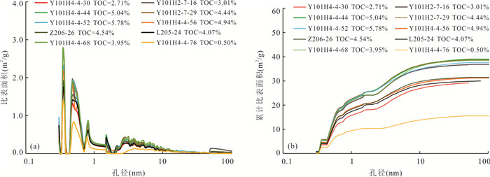
Pore distribution of shale is a key parameter of the shale reservoir, and it is important to estimate shale gas resource reserve and for shale gas exploration and development. To characterize the pore apertures of deeply buried Wufeng-Longmaxi shale in the Luzhou district, carbon dioxide and nitrogen adsorption, high pressure mercury injection and helium expansion porosity were used, combined with the oxidation-reduction condition during the deposition, moisture and TOC. The data show that mesopores were main pore types, accounting for 73% of the total pore volume on average, followed by micropores of 23%, and macropores of 4%. Pore volume changed regularly with the deposited oxidation-reduction environment, and the TOC contents dominantly controlled the pore distributions and pore volumes, especially obvious for pores of less than 10 nm in diameter. Moisture could occupy some pores, and reduce the pore surface area and pore volume, with decrease amounting to 30%. Therefore, pore distributions were jointly controlled by oxidation-reduction condition, TOC and moisture.
Pore distribution of shale is a key parameter of the shale reservoir, and it is important to estimate shale gas resource reserve and for shale gas exploration and development. To characterize the pore apertures of deeply buried Wufeng-Longmaxi shale in the Luzhou district, carbon dioxide and nitrogen adsorption, high pressure mercury injection and helium expansion porosity were used, combined with the oxidation-reduction condition during the deposition, moisture and TOC. The data show that mesopores were main pore types, accounting for 73% of the total pore volume on average, followed by micropores of 23%, and macropores of 4%. Pore volume changed regularly with the deposited oxidation-reduction environment, and the TOC contents dominantly controlled the pore distributions and pore volumes, especially obvious for pores of less than 10 nm in diameter. Moisture could occupy some pores, and reduce the pore surface area and pore volume, with decrease amounting to 30%. Therefore, pore distributions were jointly controlled by oxidation-reduction condition, TOC and moisture.


2023, 48(1): 173-190.
doi: 10.3799/dqkx.2022.218
Abstract:
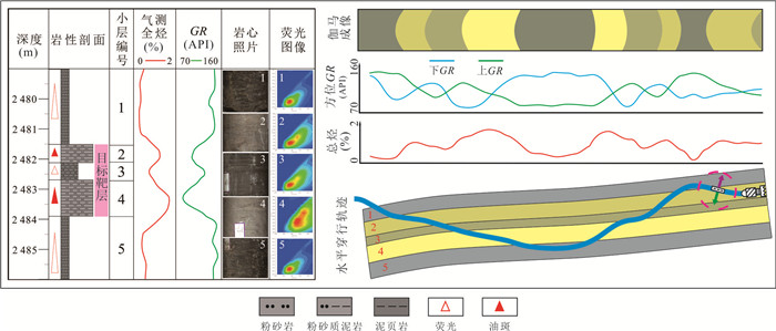
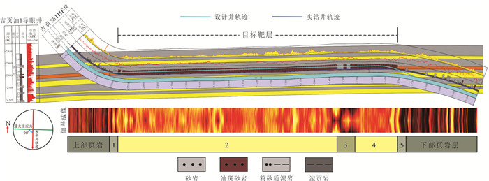
China's continental shale oil resources have great potential, but the shale reservoir has the characteristics of high clay mineral content, strong heterogeneity and low ground energy, which seriously restricts the efficient exploration of continental shale oil in China. Focusing on the key links such as sweet spot optimization, horizontal well drilling, stimulated reservoir volume and oil test for production, comprehensively utilizing the coring, logging, logging and analysis and test data of JYY1 Well system, innovative research has been carried out on geology-engineering integration. The results show that the shale of Qingyi Member in Songliao Basin can be divided into two lithofacies types: high TOC bedding clayey shale and medium TOC laminated felsic shale. The former is mainly geological sweet spot and the latter is mainly engineering sweet spot. In this study, the integrated "double sweet spot" evaluation standard of geology-engineering has been established. Based on our horizontal well design concept of "drilling sand and fracturing shale", the 1.94 m thick double sweet spot target layer was selected, and the technical breakthrough of 1 252 m horizontal drilling of ultra-thin target layer and 100% penetration rate was achieved by adopting the three-dimensional geophysical geology-engineering integration ultra-thin target layer guidance technology. The four advantages of supercritical CO2 are rock breaking, dissolution, oil displacement and energy increase. The supercritical CO2 + large-scale hydraulic sand carrying composite fracturing process and pressure controlled energy storage flowback technology have been innovated, which has realized the large-scale volume transformation of continental shale formation of JYY1 Well, and achieved a breakthrough in 16.4 m3/d high and stable shale oil, resulting in a geology-engineering integration method, technology, process and various parameters. It has reference significance for the efficient exploration and development of continental shale oil in Songliao Basin and the same type.
China's continental shale oil resources have great potential, but the shale reservoir has the characteristics of high clay mineral content, strong heterogeneity and low ground energy, which seriously restricts the efficient exploration of continental shale oil in China. Focusing on the key links such as sweet spot optimization, horizontal well drilling, stimulated reservoir volume and oil test for production, comprehensively utilizing the coring, logging, logging and analysis and test data of JYY1 Well system, innovative research has been carried out on geology-engineering integration. The results show that the shale of Qingyi Member in Songliao Basin can be divided into two lithofacies types: high TOC bedding clayey shale and medium TOC laminated felsic shale. The former is mainly geological sweet spot and the latter is mainly engineering sweet spot. In this study, the integrated "double sweet spot" evaluation standard of geology-engineering has been established. Based on our horizontal well design concept of "drilling sand and fracturing shale", the 1.94 m thick double sweet spot target layer was selected, and the technical breakthrough of 1 252 m horizontal drilling of ultra-thin target layer and 100% penetration rate was achieved by adopting the three-dimensional geophysical geology-engineering integration ultra-thin target layer guidance technology. The four advantages of supercritical CO2 are rock breaking, dissolution, oil displacement and energy increase. The supercritical CO2 + large-scale hydraulic sand carrying composite fracturing process and pressure controlled energy storage flowback technology have been innovated, which has realized the large-scale volume transformation of continental shale formation of JYY1 Well, and achieved a breakthrough in 16.4 m3/d high and stable shale oil, resulting in a geology-engineering integration method, technology, process and various parameters. It has reference significance for the efficient exploration and development of continental shale oil in Songliao Basin and the same type.


2023, 48(1): 191-205.
doi: 10.3799/dqkx.2022.422
Abstract:
The construction of shale oil demonstration area is of great significance to leading and promoting the scale benefit development of continental shale oil and the sustainable development of the industry in China. Based on the development status and construction progress of the existing national shale oil demonstration area, as well as the analysis of the situation and challenges faced, the feasibility evaluation method, evaluation parameters and index system of the (proposed) demonstration area are established. China's Longdong, Jimusar, Gulong and Jiyang demonstration areas have made two major strategic breakthroughs and reserves discovery of shale oil, five key technological breakthroughs and integrated innovation. A number of engineering and technical parameters have achieved step-by-step leapfrog upgrading, geology-engineering integration application, quality improvement and efficiency increase, forming the mechanism mode and gaining important experience in four aspects: organization and management, production and construction, technical breakthrough and measure guarantee. There are three types of shale oil developed in the demonstration area, individual achievements are lower than the approval planning objectives, potential and pressure of increasing reserves and production as well as scale benefit development coexist. According to the key contents, main methods and parameter-index system construction principles of shale oil feasibility evaluation, six categories of primary indicators (including resource feasibility, geological condition feasibility, development technology feasibility, environmental protection and energy conservation feasibility, economic feasibility and risk countermeasure feasibility), 18 categories of secondary indicators, 126 three-level indicators are established, which constitutes the feasibility evaluation index system framework of shale oil demonstration. In general, the construction of three national shale oil demonstration areas has been smoothly promoted and developed steadily. The feasibility evaluation parameter-index system pays attention to the combination of resources and geological characteristics, development technology and economic evaluation in terms of content, highlights the combination of parameter analogy method, economic evaluation method and comprehensive analysis method and queuing comparison method in terms of methods, and strengthens the feasibility evaluation of environmental protection, energy conservation and carbon reduction, risk and countermeasure analysis under the background of "dual carbon" goals in the new era. It is expected to provide decision-making reference for the feasibility evaluation and construction of shale oil demonstration areas in China.
The construction of shale oil demonstration area is of great significance to leading and promoting the scale benefit development of continental shale oil and the sustainable development of the industry in China. Based on the development status and construction progress of the existing national shale oil demonstration area, as well as the analysis of the situation and challenges faced, the feasibility evaluation method, evaluation parameters and index system of the (proposed) demonstration area are established. China's Longdong, Jimusar, Gulong and Jiyang demonstration areas have made two major strategic breakthroughs and reserves discovery of shale oil, five key technological breakthroughs and integrated innovation. A number of engineering and technical parameters have achieved step-by-step leapfrog upgrading, geology-engineering integration application, quality improvement and efficiency increase, forming the mechanism mode and gaining important experience in four aspects: organization and management, production and construction, technical breakthrough and measure guarantee. There are three types of shale oil developed in the demonstration area, individual achievements are lower than the approval planning objectives, potential and pressure of increasing reserves and production as well as scale benefit development coexist. According to the key contents, main methods and parameter-index system construction principles of shale oil feasibility evaluation, six categories of primary indicators (including resource feasibility, geological condition feasibility, development technology feasibility, environmental protection and energy conservation feasibility, economic feasibility and risk countermeasure feasibility), 18 categories of secondary indicators, 126 three-level indicators are established, which constitutes the feasibility evaluation index system framework of shale oil demonstration. In general, the construction of three national shale oil demonstration areas has been smoothly promoted and developed steadily. The feasibility evaluation parameter-index system pays attention to the combination of resources and geological characteristics, development technology and economic evaluation in terms of content, highlights the combination of parameter analogy method, economic evaluation method and comprehensive analysis method and queuing comparison method in terms of methods, and strengthens the feasibility evaluation of environmental protection, energy conservation and carbon reduction, risk and countermeasure analysis under the background of "dual carbon" goals in the new era. It is expected to provide decision-making reference for the feasibility evaluation and construction of shale oil demonstration areas in China.


2023, 48(1): 206-222.
doi: 10.3799/dqkx.2022.440
Abstract:
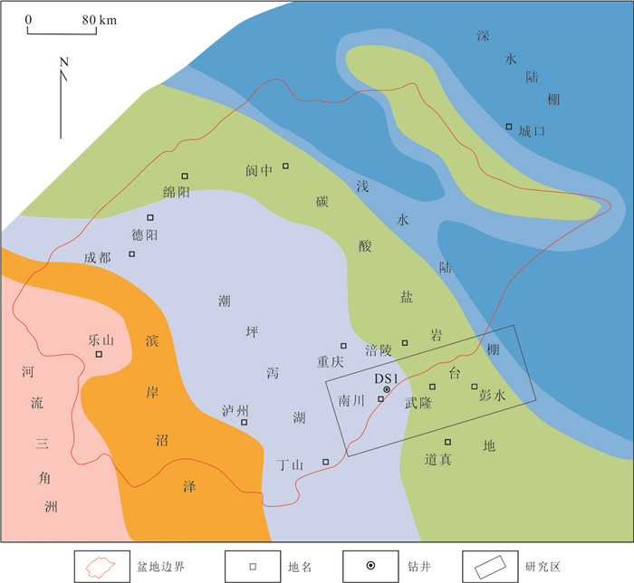
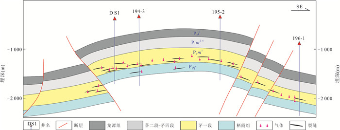
The southeastern Chongqing is located in the basin-margin transition zone on the southeast edge of Sichuan Basin. The Paleozoic strata are well-developed, but experienced multiple tectonic periods and great strength, leading to many types of natural gas and complex accumulation conditions. In order to clarify the main types of natural gas reservoirs, the characteristics of accumulation system and the stereoscopic exploration and development potential, reduce exploration risk and cost, and improve the success rate of exploration, guided by the theory of reservoir-forming system and the thought of stereoscopic exploration, this paper studies sedimentary facies, geochemical index, reservoir type, accumulation conditions, source-reservoir matching relationship and accumulation mode, and combining the exploration and development practices, two types of intra and external source accumulation systems have been identified. The intra-source accumulation system includes shale-coal bed gas reservoirs of Longtan Formation and lime-mudstone gas reservoirs of Maokou Formation of Permian, Ordovician Wufeng Formation-Silurian Longmaxi Formation and Cambrian Shuijingtuo Formation shale gas reservoirs. The external-source accumulation system includes the sandstone gas reservoirs of Xiaoheba Formation of Silurian, the carbonate gas reservoirs of Xixiangchi Group and Shilongdong Formation of Cambrian. The suggestion of stereoscopic exploration is mainly lower shale gas of Wufeng-Longmaxi Formation, and the upper shale gas of Longtan Formation and Maokou Formation is subsidiary, and at the same time to explore the external-source of sandstone and carbonate gas reservoirs. The discovery of multiple commercial gas-bearing strata as many as possible is of great practical significance for sustainable exploration. Comprehensive study of the reservoir forming conditions and enrichment regularity of natural gas in intra-source accumulation system and external-source accumulation system, it is regarded that Nanchuan area is a favorable stereoscopic exploration area for Permian, Silurian and Cambrian strata, and Pengshui area is a favorable stereoscopic exploration area for Silurian and Cambrian strata.
The southeastern Chongqing is located in the basin-margin transition zone on the southeast edge of Sichuan Basin. The Paleozoic strata are well-developed, but experienced multiple tectonic periods and great strength, leading to many types of natural gas and complex accumulation conditions. In order to clarify the main types of natural gas reservoirs, the characteristics of accumulation system and the stereoscopic exploration and development potential, reduce exploration risk and cost, and improve the success rate of exploration, guided by the theory of reservoir-forming system and the thought of stereoscopic exploration, this paper studies sedimentary facies, geochemical index, reservoir type, accumulation conditions, source-reservoir matching relationship and accumulation mode, and combining the exploration and development practices, two types of intra and external source accumulation systems have been identified. The intra-source accumulation system includes shale-coal bed gas reservoirs of Longtan Formation and lime-mudstone gas reservoirs of Maokou Formation of Permian, Ordovician Wufeng Formation-Silurian Longmaxi Formation and Cambrian Shuijingtuo Formation shale gas reservoirs. The external-source accumulation system includes the sandstone gas reservoirs of Xiaoheba Formation of Silurian, the carbonate gas reservoirs of Xixiangchi Group and Shilongdong Formation of Cambrian. The suggestion of stereoscopic exploration is mainly lower shale gas of Wufeng-Longmaxi Formation, and the upper shale gas of Longtan Formation and Maokou Formation is subsidiary, and at the same time to explore the external-source of sandstone and carbonate gas reservoirs. The discovery of multiple commercial gas-bearing strata as many as possible is of great practical significance for sustainable exploration. Comprehensive study of the reservoir forming conditions and enrichment regularity of natural gas in intra-source accumulation system and external-source accumulation system, it is regarded that Nanchuan area is a favorable stereoscopic exploration area for Permian, Silurian and Cambrian strata, and Pengshui area is a favorable stereoscopic exploration area for Silurian and Cambrian strata.


2023, 48(1): 223-234.
doi: 10.3799/dqkx.2022.333
Abstract:
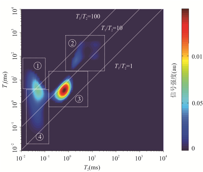
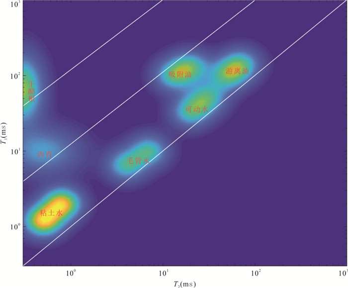
Mahu Fengcheng Formation shale oil is a new field of oil and gas exploration in Junggar Basin. Clarifying its high-quality "sweet spot" development section is of great significance to the oil test horizon and the deployment of horizontal wells. Starting with two key geological engineering parameters in shale oil evaluation: free oil and brittleness index, and based on the systematic experimental site, in this paper it studies the logging evaluation method of free oil and brittleness index of shale oil in Mahu Fengcheng Formation, analyzes the influence of the two parameters on production, establishes the calculation model of production potential index, and forms the "sweet spot" classification method. The research shows that: (1) (T2, T1) 2D NMR method can effectively distinguish movable water, free oil and adsorbed oil (T1/T2: movable water < free oil < adsorbed oil). The porosity of free oil in shale reservoir of Fengcheng Formation is low, mainly 0.5%-3.0%. (2) Shale oil layer has good brittleness, and the brittleness index is more than 70%, but the Young's modulus is large, so it is difficult to start fracturing by hydraulic fracturing. (3) According to the productivity potential index, it is divided into three types of sweet spots. Vertically, the three types of sweet spots are overlapped and developed, and three sets of high-quality sweet spots can be selected. The key technology of shale oil sweet spot evaluation proposed in the research provides an important basis for shale oil testing and layer selection of Fengcheng Formation and target layer selection of horizontal wells. This technical method can provide a reference for shale oil sweet spot evaluation in other continental basins in China.
Mahu Fengcheng Formation shale oil is a new field of oil and gas exploration in Junggar Basin. Clarifying its high-quality "sweet spot" development section is of great significance to the oil test horizon and the deployment of horizontal wells. Starting with two key geological engineering parameters in shale oil evaluation: free oil and brittleness index, and based on the systematic experimental site, in this paper it studies the logging evaluation method of free oil and brittleness index of shale oil in Mahu Fengcheng Formation, analyzes the influence of the two parameters on production, establishes the calculation model of production potential index, and forms the "sweet spot" classification method. The research shows that: (1) (T2, T1) 2D NMR method can effectively distinguish movable water, free oil and adsorbed oil (T1/T2: movable water < free oil < adsorbed oil). The porosity of free oil in shale reservoir of Fengcheng Formation is low, mainly 0.5%-3.0%. (2) Shale oil layer has good brittleness, and the brittleness index is more than 70%, but the Young's modulus is large, so it is difficult to start fracturing by hydraulic fracturing. (3) According to the productivity potential index, it is divided into three types of sweet spots. Vertically, the three types of sweet spots are overlapped and developed, and three sets of high-quality sweet spots can be selected. The key technology of shale oil sweet spot evaluation proposed in the research provides an important basis for shale oil testing and layer selection of Fengcheng Formation and target layer selection of horizontal wells. This technical method can provide a reference for shale oil sweet spot evaluation in other continental basins in China.


2023, 48(1): 235-251.
doi: 10.3799/dqkx.2022.140
Abstract:
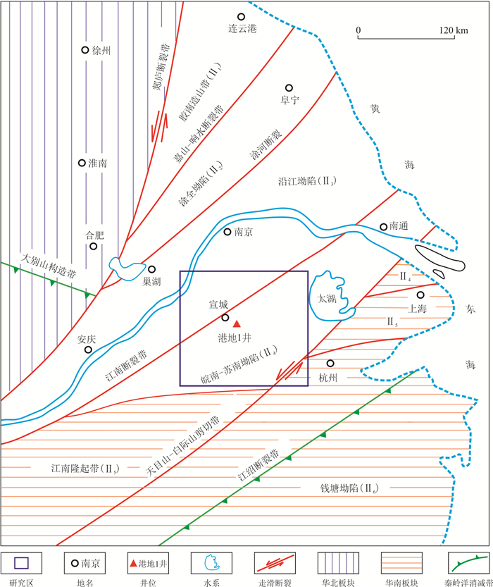
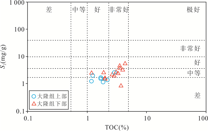
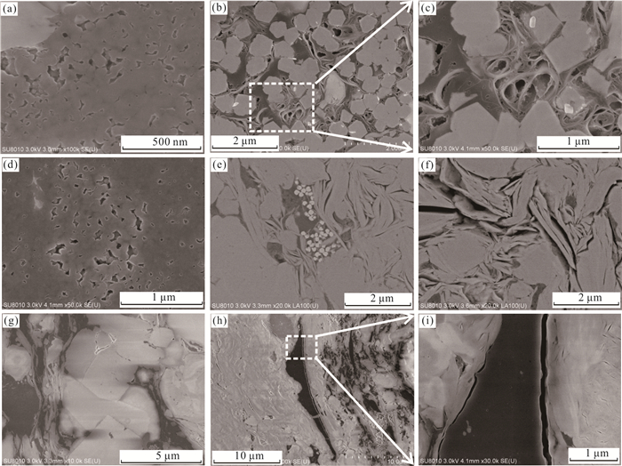
In order to elucidate shale characteristics of the Upper Permian Dalong Formation in southern Anhui Province in the Lower Yangtze, a total of 20 shale samples collected from Gangdi-1 Well were analyzed by conducting organic geochemical test, argon ion polishing-scanning electron microscopy (SEM) observation, and mineral composition analysis. Results show that total organic carbon (TOC) content for the Dalong Formation shale in southern Anhui Province is in the range of 1.18%-4.35%. The kerogen type is dominated by type Ⅰ and followed by type Ⅱ1. The vitrinite reflectance (Ro) is between 1.15% and 1.29%, demonstrating that the Dalong Formation shale is in a mature stage of hydrocarbon generation. Moreover, the Dalong Formation shale extracts display a full range of C11-C35 n-alkanes and acyclic isoprenoids. The chromatograms are characterized by a unimodal distribution of n-alkanes with carbon peak in the range of nC18-nC22 and low quantities of long-chain (nC25+) n-alkanes. Furthermore, the steranes are dominated by C27, C28, and C29 sterane homologs of regular steranes, with the following relative distributions: C27≈C29>C28 regular steranes, which belongs to the V-shaped distribution, indicating that the organic matters in Dalong Formation black shale are mainly originated from lower aquatic organisms (e.g., bacteria and algae) and followed by higher plants in a local area. This conclusion is also supported by the variations of the δ13C values of C13-C26 n-alkanes for the target samples being in the range of 3.0‰-5.6‰ offset, which is slightly higher than the corresponding value (1.6‰) of n-alkanes from a single source. In addition, the cross plot of TOC vs. TS as well as the Pr/Ph ratio and the Pr/nC17-Ph/nC18 diagram indicate that Dalong Formation black shale was mainly formed in a marine anoxic-dysoxic environment, which is beneficial to the preservation of organic matter.
In order to elucidate shale characteristics of the Upper Permian Dalong Formation in southern Anhui Province in the Lower Yangtze, a total of 20 shale samples collected from Gangdi-1 Well were analyzed by conducting organic geochemical test, argon ion polishing-scanning electron microscopy (SEM) observation, and mineral composition analysis. Results show that total organic carbon (TOC) content for the Dalong Formation shale in southern Anhui Province is in the range of 1.18%-4.35%. The kerogen type is dominated by type Ⅰ and followed by type Ⅱ1. The vitrinite reflectance (Ro) is between 1.15% and 1.29%, demonstrating that the Dalong Formation shale is in a mature stage of hydrocarbon generation. Moreover, the Dalong Formation shale extracts display a full range of C11-C35 n-alkanes and acyclic isoprenoids. The chromatograms are characterized by a unimodal distribution of n-alkanes with carbon peak in the range of nC18-nC22 and low quantities of long-chain (nC25+) n-alkanes. Furthermore, the steranes are dominated by C27, C28, and C29 sterane homologs of regular steranes, with the following relative distributions: C27≈C29>C28 regular steranes, which belongs to the V-shaped distribution, indicating that the organic matters in Dalong Formation black shale are mainly originated from lower aquatic organisms (e.g., bacteria and algae) and followed by higher plants in a local area. This conclusion is also supported by the variations of the δ13C values of C13-C26 n-alkanes for the target samples being in the range of 3.0‰-5.6‰ offset, which is slightly higher than the corresponding value (1.6‰) of n-alkanes from a single source. In addition, the cross plot of TOC vs. TS as well as the Pr/Ph ratio and the Pr/nC17-Ph/nC18 diagram indicate that Dalong Formation black shale was mainly formed in a marine anoxic-dysoxic environment, which is beneficial to the preservation of organic matter.


2023, 48(1): 252-266.
doi: 10.3799/dqkx.2022.137
Abstract:
The shallow shale gas in the Zhaotong area has a wide distribution and large geological reserves, with a large development potential. To realize the efficient production and resource utilization of shallow shale gas in the Haiba backslope of the central area, based on the experience of the Taiyang backslope, the feasibility of the stereoscopic development of shallow shale gas in Haiba and the deployment of the well pattern were explored, based on the geology-engineering integration concept and research workflow. The research result shows that the best target for single-layer development is still the Long 111 layer, and the Wufeng Formation does not have the conditions for economic development as an independent development layer system under the current process technology and economic index, and further exploration is still needed. The thickness of Class Ⅰ+Ⅱ high quality reservoir between Long 111 layer + Long 113 layer is large, compared with the development of Long 111 single layer, using Long 111 minor layer + Long 113 layer with stereoscopic staggered well pattern in the same well spacing and number of wells, the platform EUR and IRR are greatly increased. Under the same control area conditions, there is an optimal interval between well spacing and well number, and 250 m is recommended as the best well spacing under the current technology and economic index; if the well construction cost decreases, there is a potential to further reduce the well spacing and improve the overall EUR of the platform. Large-scale hydraulic fracturing will not only change the in-situ stress magnitude, but also change the horizontal principal stress direction, thus changing the stress state in the near-well zone from a walking-slip to a reverse-fault state, and adversely affecting the hydraulic fracturing due to T shape fracture. One-time well deployment can effectively reduce negative inter-well stress interference and improve the degree of inter-well reserve utilization compared to the infill well pattern deployment. In conclusion, the development of shallow shale gas in Haiba is suitable to adopt a stereoscopic staggered one-time well pattern with small well spacing, promoting the development of Zhaotong area shallow shale gas in a cost-effective way.
The shallow shale gas in the Zhaotong area has a wide distribution and large geological reserves, with a large development potential. To realize the efficient production and resource utilization of shallow shale gas in the Haiba backslope of the central area, based on the experience of the Taiyang backslope, the feasibility of the stereoscopic development of shallow shale gas in Haiba and the deployment of the well pattern were explored, based on the geology-engineering integration concept and research workflow. The research result shows that the best target for single-layer development is still the Long 111 layer, and the Wufeng Formation does not have the conditions for economic development as an independent development layer system under the current process technology and economic index, and further exploration is still needed. The thickness of Class Ⅰ+Ⅱ high quality reservoir between Long 111 layer + Long 113 layer is large, compared with the development of Long 111 single layer, using Long 111 minor layer + Long 113 layer with stereoscopic staggered well pattern in the same well spacing and number of wells, the platform EUR and IRR are greatly increased. Under the same control area conditions, there is an optimal interval between well spacing and well number, and 250 m is recommended as the best well spacing under the current technology and economic index; if the well construction cost decreases, there is a potential to further reduce the well spacing and improve the overall EUR of the platform. Large-scale hydraulic fracturing will not only change the in-situ stress magnitude, but also change the horizontal principal stress direction, thus changing the stress state in the near-well zone from a walking-slip to a reverse-fault state, and adversely affecting the hydraulic fracturing due to T shape fracture. One-time well deployment can effectively reduce negative inter-well stress interference and improve the degree of inter-well reserve utilization compared to the infill well pattern deployment. In conclusion, the development of shallow shale gas in Haiba is suitable to adopt a stereoscopic staggered one-time well pattern with small well spacing, promoting the development of Zhaotong area shallow shale gas in a cost-effective way.


2023, 48(1): 267-278.
doi: 10.3799/dqkx.2022.383
Abstract:
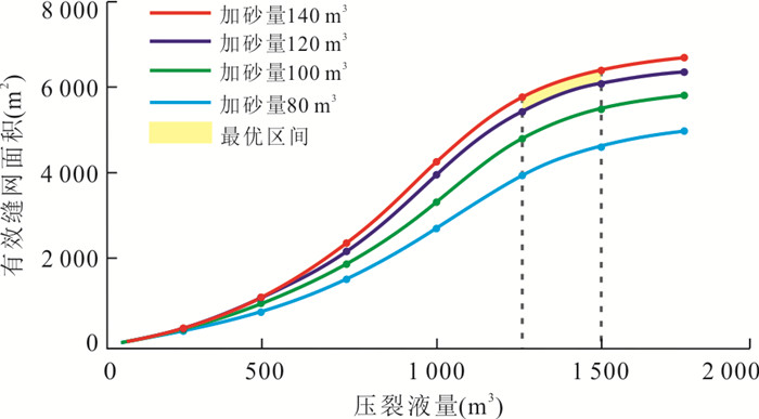
Geology-engineering integration policy is an important way to reduce cost and increase efficiency of shale gas. Integrated and quantitative approach is an important development direction of integrated optimization decision research. However, the current quantitative optimization is more often performed for single well, and the optimal fracture half-length/horizontal well length obtained from the optimization of a single well is often used as the basis for well pattern deployment. In this paper, it compares the sensitivity of single-well and block optimization results to major geological conditions and engineering parameters based on the objective functions of single-well and block benefits constructed using operational research techniques. The results show that although the benefits of both single-well and block show a trend of increasing and then decreasing with increasing fracture size (fracture half-length), the optimal fracture half-lengths are significantly different. Meanwhile, with the increase of porosity, gas saturation, pressure coefficient, natural gas price, fracturing cost and drilling cost, the optimal fracture half length of single well and block varies. It indicates that the optimal values obtained for blocks and single well are not consistent, and wells should be laid out with the results of the overall geology-engineering integration optimization of the blocks. This finding has realistic implications for the optimal deployment and efficient development of shale gas and other unconventional oil and gas well networks.
Geology-engineering integration policy is an important way to reduce cost and increase efficiency of shale gas. Integrated and quantitative approach is an important development direction of integrated optimization decision research. However, the current quantitative optimization is more often performed for single well, and the optimal fracture half-length/horizontal well length obtained from the optimization of a single well is often used as the basis for well pattern deployment. In this paper, it compares the sensitivity of single-well and block optimization results to major geological conditions and engineering parameters based on the objective functions of single-well and block benefits constructed using operational research techniques. The results show that although the benefits of both single-well and block show a trend of increasing and then decreasing with increasing fracture size (fracture half-length), the optimal fracture half-lengths are significantly different. Meanwhile, with the increase of porosity, gas saturation, pressure coefficient, natural gas price, fracturing cost and drilling cost, the optimal fracture half length of single well and block varies. It indicates that the optimal values obtained for blocks and single well are not consistent, and wells should be laid out with the results of the overall geology-engineering integration optimization of the blocks. This finding has realistic implications for the optimal deployment and efficient development of shale gas and other unconventional oil and gas well networks.


2023, 48(1): 279-292.
doi: 10.3799/dqkx.2022.446
Abstract:
Thick organic-rich shale with thin silty sandstones is developed in Chang 73 Sub-member of Yanchang Formation in Ordos Basin. The sandstones in deep water environment are charged high intensity by source rocks and have a certain scale, which is an important target of deep water exploration in the basin. Based on the core, logging and test data of Chang 73 Sub-member, combined with the risk exploration practice of Lingye and Chiye horizontal wells, this paper discusses and analyzes the sedimentary and reservoir characteristics of deep-water sandy rocks in Chang 73 Sub-member. The results show that during the Chang 73 sedimentary period, the water body was deep, organic-rich shale was developed, the Qiqin orogenic belt in the southwest of the basin had frequent seismic and volcanic activities, and the source supply was sufficient, the rainfall was large and the lake level was rising. The gravity flow deposits of slump origin and flood origin were widely developed in the middle of the basin. Slope break belt controlled the development of deep-water gravity flow, the characteristics of deep-water gravity flow were controlled by the ancient landform and sedimentary microfacies, developing sliding-slump, sandy debris flow, hybrid event bed, turbidity current and density flow, such as slope break zone of slope toe, relatively rich ancient channel sand, sandy debris flow and turbidity current deposits are favorable reservoir types. The single sand body is thin, with an average thickness of 1 m, and is isolated or superimposed. In terms of spatial thickness, length and width, the combination of thick block single sand body and tightly continuous superimposed thin single sand body is the reservoir expected to be drilled. Shale with high Ro and high TOC is the material basis for sandy rock. Under high residual pressure difference, high-quality sandy "sweet spot" is most likely to appear in the source-reservoir configuration relationship between tightly stacked thin sandstone reservoir with better reservoir performance and interbedded high-quality source rock. The exploration potential of deep-water sandy rocks in Chang 73 Sub-member is good, so it is necessary to continuously explore the geophysical exploration technology of thin reservoir and the matched fracturing technology.
Thick organic-rich shale with thin silty sandstones is developed in Chang 73 Sub-member of Yanchang Formation in Ordos Basin. The sandstones in deep water environment are charged high intensity by source rocks and have a certain scale, which is an important target of deep water exploration in the basin. Based on the core, logging and test data of Chang 73 Sub-member, combined with the risk exploration practice of Lingye and Chiye horizontal wells, this paper discusses and analyzes the sedimentary and reservoir characteristics of deep-water sandy rocks in Chang 73 Sub-member. The results show that during the Chang 73 sedimentary period, the water body was deep, organic-rich shale was developed, the Qiqin orogenic belt in the southwest of the basin had frequent seismic and volcanic activities, and the source supply was sufficient, the rainfall was large and the lake level was rising. The gravity flow deposits of slump origin and flood origin were widely developed in the middle of the basin. Slope break belt controlled the development of deep-water gravity flow, the characteristics of deep-water gravity flow were controlled by the ancient landform and sedimentary microfacies, developing sliding-slump, sandy debris flow, hybrid event bed, turbidity current and density flow, such as slope break zone of slope toe, relatively rich ancient channel sand, sandy debris flow and turbidity current deposits are favorable reservoir types. The single sand body is thin, with an average thickness of 1 m, and is isolated or superimposed. In terms of spatial thickness, length and width, the combination of thick block single sand body and tightly continuous superimposed thin single sand body is the reservoir expected to be drilled. Shale with high Ro and high TOC is the material basis for sandy rock. Under high residual pressure difference, high-quality sandy "sweet spot" is most likely to appear in the source-reservoir configuration relationship between tightly stacked thin sandstone reservoir with better reservoir performance and interbedded high-quality source rock. The exploration potential of deep-water sandy rocks in Chang 73 Sub-member is good, so it is necessary to continuously explore the geophysical exploration technology of thin reservoir and the matched fracturing technology.


2023, 48(1): 293-316.
doi: 10.3799/dqkx.2022.463
Abstract:
The Ordos Basin is one of the main petroliferous basins in China. The Triassic Yanchang Formation is the main oil-bearing units in this basin. Based on the investigation and study of typical outcrops of Yanchang Formation and the data of paleontology, lithology and lithofacies, three new insights are obtained. (1) The paleoclimatic environment of Yanchang Formation during the sedimentary period has been recovered, which is considered to be tripartite, and the Ladinian Age was an arid environment. During the Carnian Age, the climate changed to a warm and humid environment because of the Carnian Pluvial Episode (CPE). In the Norian-Rhaetian ages, the climate environment changed to semi-arid and sub-humid again. (2) The CPE changed the way of sediment transport and deposition in the Yanchang Formation. In the dry environment period before and after the CPE, the seasonal river, crevasse splay and crevasse channels caused by rainstorm and flood were mainly developed. During the CPE and in the mid-Carnian period, terrigenous detrital materials were transported to the underwater environment mainly by various gravity flows such as turbidity flow, sandy debris flow and hyperpycnal flow, forming sandy event deposits. At the same time, controlled by the CPE, black organic-rich shale event deposits were also developed in the deep water environment. (3) Two sedimentary models of arid and humid environments were established in the Yanchang Formation. In the former, the catchment area in the arid environment was small, and the main sedimentary units were flood plain, seasonal channel, crevasse splay, crevasse channels and so on. In the latter, the catchment area of the humid environment is large, and the complete continental fluvial, delta-lacustrine and gravity flow sedimentary system is developed. Due to the stable long-flowing water, the channel is relatively fixed, the sedimentation mode is mainly progradation, supplemented by retrogradation, and not obvious aggradation. The study is of practical value to the discussion of how the large depressed lake basin formed and evolved in the Yanchang Formation, sedimentary sequence evolution, and petroleum exploration, and it is also significant to the study of the sedimentological records in inland lake basins generated by global extreme climate events in the Late Triassic Epoch to understand the sedimentary responses of the Carnian Pluvial Episode in the Pangea at the east margin of the Paleo-Tethys.
The Ordos Basin is one of the main petroliferous basins in China. The Triassic Yanchang Formation is the main oil-bearing units in this basin. Based on the investigation and study of typical outcrops of Yanchang Formation and the data of paleontology, lithology and lithofacies, three new insights are obtained. (1) The paleoclimatic environment of Yanchang Formation during the sedimentary period has been recovered, which is considered to be tripartite, and the Ladinian Age was an arid environment. During the Carnian Age, the climate changed to a warm and humid environment because of the Carnian Pluvial Episode (CPE). In the Norian-Rhaetian ages, the climate environment changed to semi-arid and sub-humid again. (2) The CPE changed the way of sediment transport and deposition in the Yanchang Formation. In the dry environment period before and after the CPE, the seasonal river, crevasse splay and crevasse channels caused by rainstorm and flood were mainly developed. During the CPE and in the mid-Carnian period, terrigenous detrital materials were transported to the underwater environment mainly by various gravity flows such as turbidity flow, sandy debris flow and hyperpycnal flow, forming sandy event deposits. At the same time, controlled by the CPE, black organic-rich shale event deposits were also developed in the deep water environment. (3) Two sedimentary models of arid and humid environments were established in the Yanchang Formation. In the former, the catchment area in the arid environment was small, and the main sedimentary units were flood plain, seasonal channel, crevasse splay, crevasse channels and so on. In the latter, the catchment area of the humid environment is large, and the complete continental fluvial, delta-lacustrine and gravity flow sedimentary system is developed. Due to the stable long-flowing water, the channel is relatively fixed, the sedimentation mode is mainly progradation, supplemented by retrogradation, and not obvious aggradation. The study is of practical value to the discussion of how the large depressed lake basin formed and evolved in the Yanchang Formation, sedimentary sequence evolution, and petroleum exploration, and it is also significant to the study of the sedimentological records in inland lake basins generated by global extreme climate events in the Late Triassic Epoch to understand the sedimentary responses of the Carnian Pluvial Episode in the Pangea at the east margin of the Paleo-Tethys.


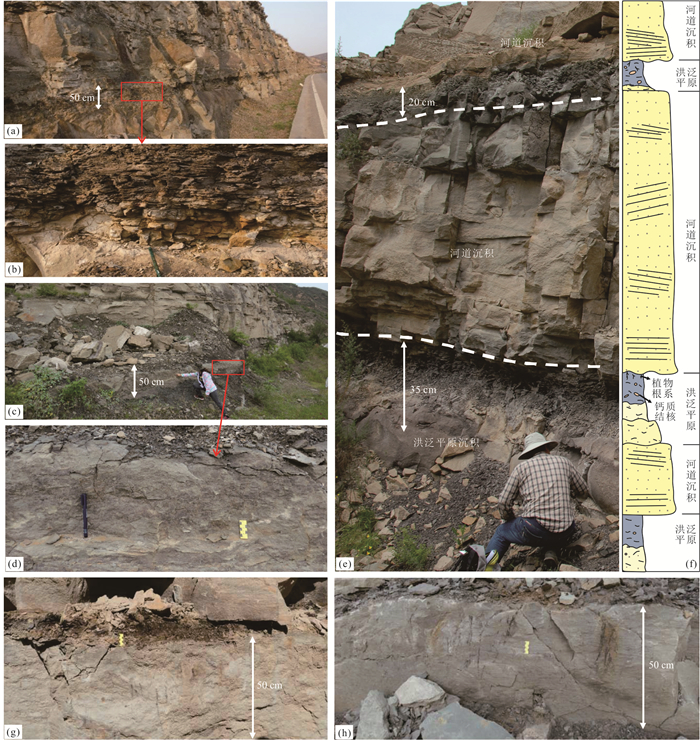
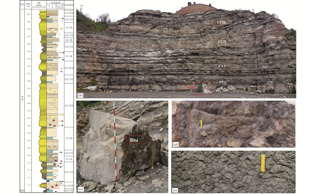


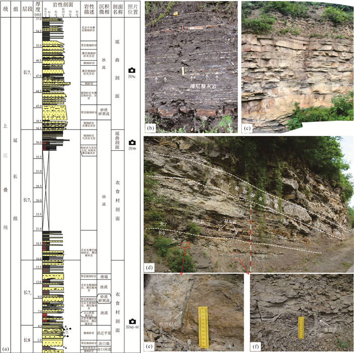

2023, 48(1): 317-328.
doi: 10.3799/dqkx.2021.257
Abstract:
Thick Cenozoic strata are developed in the Yinchuan Basin, among which the Qingshuiying Formation is the period of salinized lake basin development and the most developed layer of hydrocarbon source rocks. Therefore, it is of great geological significance and exploration significance to clarify the sedimentary characteristics and lake basin evolution of the Qingshuiying Formation. In this paper, the lithology and petrographic types of the Late Paleoproterozoic Qingshuiying Formation in the Yinchuan Basin are analyzed and summarized using field outcrops, drill cores, logs and organic geochemical data to clarify the depositional environment. The sedimentary cyclogenesis of the Qingshuiying Formation was identified and classified using rock-electric characteristics and wavelet transform, and the evolution of the lake basin was analyzed on this basis. The lithology of the Qingshuiying Formation is mainly gray mudstone, brown-red mudstone, gypsum-bearing mudstone, gypsum and thin-bedded fine sandstone and siltstone, etc., and there are four types of petrographic assemblages. The Qingshuiying Formation can be divided into three four-order sedimentary cycles, corresponding to the three evolutionary stages of the salinized lake basin of the Qingshuiying Formation. SQ1 is the development stage of the salinized lake basin at the early stage of rifting. SQ2 is the period of strong rifting, in which the depth of the water body of the lake basin has increased, and the salinized lake is at its peak stage. SQ3 is the period when the water body becomes shallow, in which the scope of the lake basin becomes larger, the closure weakens, and the saline lake evolves into a freshwater lake.
Thick Cenozoic strata are developed in the Yinchuan Basin, among which the Qingshuiying Formation is the period of salinized lake basin development and the most developed layer of hydrocarbon source rocks. Therefore, it is of great geological significance and exploration significance to clarify the sedimentary characteristics and lake basin evolution of the Qingshuiying Formation. In this paper, the lithology and petrographic types of the Late Paleoproterozoic Qingshuiying Formation in the Yinchuan Basin are analyzed and summarized using field outcrops, drill cores, logs and organic geochemical data to clarify the depositional environment. The sedimentary cyclogenesis of the Qingshuiying Formation was identified and classified using rock-electric characteristics and wavelet transform, and the evolution of the lake basin was analyzed on this basis. The lithology of the Qingshuiying Formation is mainly gray mudstone, brown-red mudstone, gypsum-bearing mudstone, gypsum and thin-bedded fine sandstone and siltstone, etc., and there are four types of petrographic assemblages. The Qingshuiying Formation can be divided into three four-order sedimentary cycles, corresponding to the three evolutionary stages of the salinized lake basin of the Qingshuiying Formation. SQ1 is the development stage of the salinized lake basin at the early stage of rifting. SQ2 is the period of strong rifting, in which the depth of the water body of the lake basin has increased, and the salinized lake is at its peak stage. SQ3 is the period when the water body becomes shallow, in which the scope of the lake basin becomes larger, the closure weakens, and the saline lake evolves into a freshwater lake.

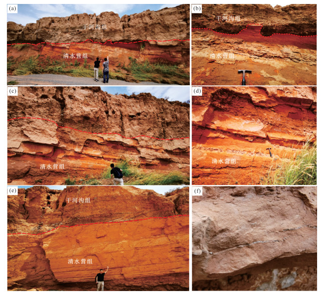


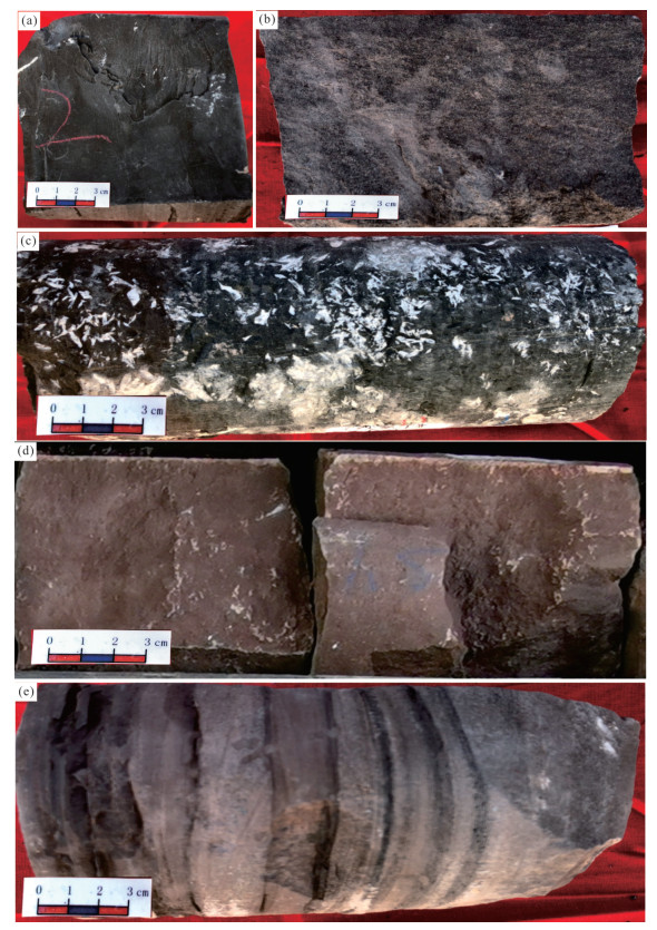
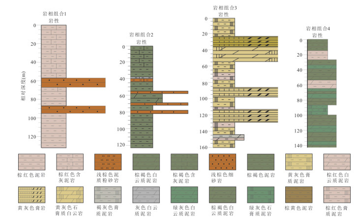


2023, 48(1): 329-341.
doi: 10.3799/dqkx.2022.406
Abstract:
The large-scale buried⁃hill oil and gas discovery in Bohai Sea is concentrated in the Archean metamorphic rocks at the mountain top, while the Lower Paleozoic carbonate rocks are developed in the slope zone, and the existing geological models are difficult to explain their accumulation laws. In this paper, core, thin section, seismic, imaging logging, analysis and laboratory data are used to study the characteristics of the Lower Paleozoic reservoir and the main controlling factors of reservoir formation in the northwestern Shaleitian Uplift. The results show that "fracture cave" type reservoirs are developed in the Lower Paleozoic carbonate rocks in this area, and the reservoir space is controlled by two factors: fractures and karst. Three periods of fault activities since Indosinian formed a series of structural stratigraphic traps. The overpressure of the hydrocarbon generating stove in the northern Nanpu Sag provides a strong filling and injection condition for reservoir formation, the Cenozoic draped mudstone provides a regional sealing condition, and the tight limestone at the updip end of the fault block provides a shielding condition for oil and gas accumulation in the slope zone. Therefore, the reservoir forming model of carbonate buried⁃hill in slope zone of "ancient reservoir, ancient plugging and overpressure injection" is established, which provides a new idea for buried⁃hill oil and gas exploration.
The large-scale buried⁃hill oil and gas discovery in Bohai Sea is concentrated in the Archean metamorphic rocks at the mountain top, while the Lower Paleozoic carbonate rocks are developed in the slope zone, and the existing geological models are difficult to explain their accumulation laws. In this paper, core, thin section, seismic, imaging logging, analysis and laboratory data are used to study the characteristics of the Lower Paleozoic reservoir and the main controlling factors of reservoir formation in the northwestern Shaleitian Uplift. The results show that "fracture cave" type reservoirs are developed in the Lower Paleozoic carbonate rocks in this area, and the reservoir space is controlled by two factors: fractures and karst. Three periods of fault activities since Indosinian formed a series of structural stratigraphic traps. The overpressure of the hydrocarbon generating stove in the northern Nanpu Sag provides a strong filling and injection condition for reservoir formation, the Cenozoic draped mudstone provides a regional sealing condition, and the tight limestone at the updip end of the fault block provides a shielding condition for oil and gas accumulation in the slope zone. Therefore, the reservoir forming model of carbonate buried⁃hill in slope zone of "ancient reservoir, ancient plugging and overpressure injection" is established, which provides a new idea for buried⁃hill oil and gas exploration.

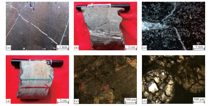

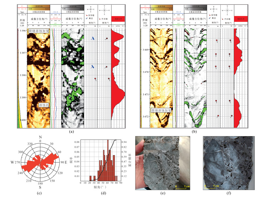

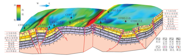
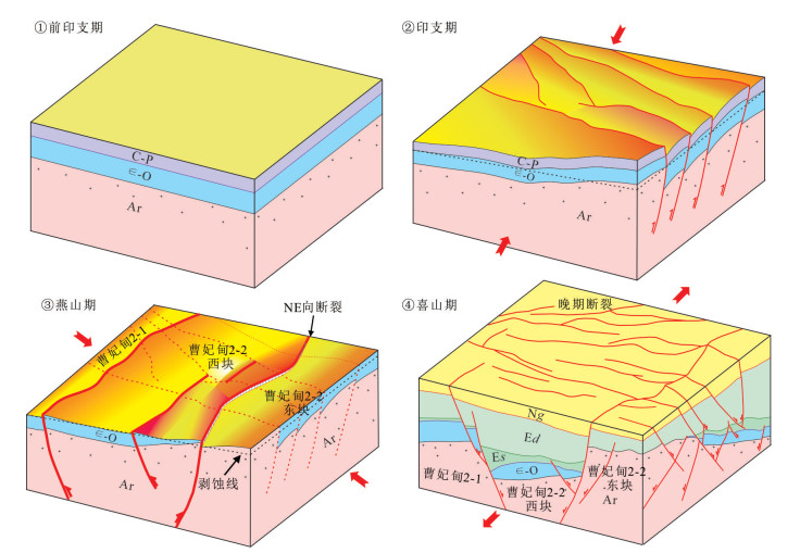


2023, 48(1): 342-358.
doi: 10.3799/dqkx.2021.131
Abstract:
Based on thin section and core data, quartz bridges in natural fractures of Cretaceous sandstones of the Keshen-Dabei area in the Kuqa foreland thrust belt were discovered by SEM, fluid inclusions and ion microprobe in-situ isotope. Quartz bridge is highly localized overgrowth accumulations that span fracture walls and is scattered on the fracture surface. Fluid inclusion assemblages sub-parallel to the fracture walls were observed in the quartz bridge. Their homogenization temperature range (150-176 ℃) is different from that of the fluid inclusions in quartz grains (90-120 ℃). Besides, the scope of δ18OVSMOWvalues (17‰-21‰) does not overlap with that of quartz grain and quartz secondary enlargement (8‰-17‰). In the Cretaceous sandstone of the Keshen and Dabei area, quartz bridges are widespread in the hinge-parallel fractures. The formation of quartz bridge may be related to the extension during folding in the high-temperature at great depth and the migration of 18O-enriched water of Paleogene evaporates. The research of the quartz bridge is a frontier and practical field, which has great significance for reconstructing fracture opening history and preserving fracture physical properties.
Based on thin section and core data, quartz bridges in natural fractures of Cretaceous sandstones of the Keshen-Dabei area in the Kuqa foreland thrust belt were discovered by SEM, fluid inclusions and ion microprobe in-situ isotope. Quartz bridge is highly localized overgrowth accumulations that span fracture walls and is scattered on the fracture surface. Fluid inclusion assemblages sub-parallel to the fracture walls were observed in the quartz bridge. Their homogenization temperature range (150-176 ℃) is different from that of the fluid inclusions in quartz grains (90-120 ℃). Besides, the scope of δ18OVSMOWvalues (17‰-21‰) does not overlap with that of quartz grain and quartz secondary enlargement (8‰-17‰). In the Cretaceous sandstone of the Keshen and Dabei area, quartz bridges are widespread in the hinge-parallel fractures. The formation of quartz bridge may be related to the extension during folding in the high-temperature at great depth and the migration of 18O-enriched water of Paleogene evaporates. The research of the quartz bridge is a frontier and practical field, which has great significance for reconstructing fracture opening history and preserving fracture physical properties.


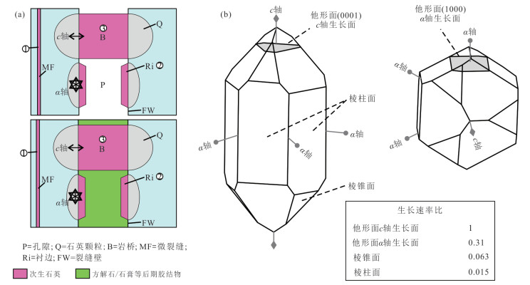

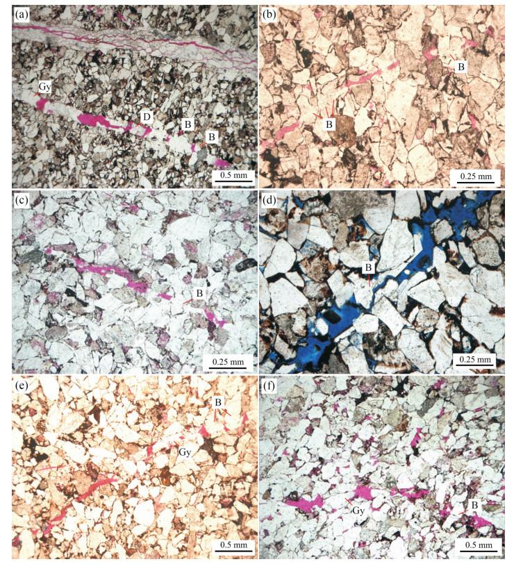


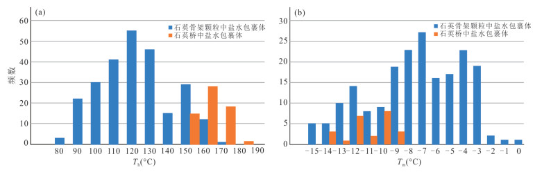


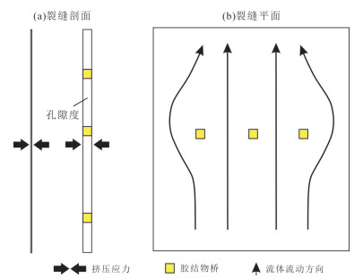

2023, 48(1): 359-374.
doi: 10.3799/dqkx.2022.413
Abstract:
River confluence has a great potential of hydrocarbon reservoirs owing to wide and thick channel-fill deposits by widening and deepening effects. The Mesozoic and Cenozoic hydrocarbon-bearing basins in China are internally drainage basins dominated and fluvial deposits are widely regarded as important hydrocarbon. The (semi-) arid regions cover 41% of the global continental areas, and river systems are widely distributed with substantial ecological resources. However, current research on river confluence is mainly focused on humid regions, and research on the channel morphology of river confluence in drylands and their controls has been rarely reported. In this study, we select the confluence (Kalakashen River and Yulongkashen River) of the Hotan River in Tarim Basin as study area. Firstly, the combination of Digital Elevation Model (DEM) and high-resolution Google Earth images were used to identify the bankfull boundaries of all river channels. Subsequently the evolution of river planform in the confluence area was analyzed using hydrological data and time-series remote sensing images. Results show that the confluence of Hotan River is a fixed and "Y" type confluence, and their junctions have different river types: Kalakashen River is meandering while Yulongkashen River is meandering-braided transitional. Cutoffs occurred along these junctions. The confluence is transformed into braided river, and its bankfull width increases by 58% (505 m wider) compared with that of junctions. Furthermore, we select 23 river confluences in typical semi-arid-arid regions (n= 10) and humid regions (n=13) around the world to investigate the changes in bankfull width from junctions to confluences. Results reveal that the increase (> 50%) in bankfull widths of river confluence in drylands with (non-) sparse vegetation greatly exceeded that (17%) of river confluence in humid areas with riparian vegetation. Slopes (2‰) of these selected dryland rivers (lack of riparian vegetation) are on average one category higher than those (0.6‰) in humid regions. Therefore, lack of riparian vegetation and high slope of river profiles are the main controls for significant widening in river confluences of dryland regions. Our results not only complement the models of river confluence, but also provide a basis for the further research of sedimentary processes and their sedimentary model in dryland river confluence.
River confluence has a great potential of hydrocarbon reservoirs owing to wide and thick channel-fill deposits by widening and deepening effects. The Mesozoic and Cenozoic hydrocarbon-bearing basins in China are internally drainage basins dominated and fluvial deposits are widely regarded as important hydrocarbon. The (semi-) arid regions cover 41% of the global continental areas, and river systems are widely distributed with substantial ecological resources. However, current research on river confluence is mainly focused on humid regions, and research on the channel morphology of river confluence in drylands and their controls has been rarely reported. In this study, we select the confluence (Kalakashen River and Yulongkashen River) of the Hotan River in Tarim Basin as study area. Firstly, the combination of Digital Elevation Model (DEM) and high-resolution Google Earth images were used to identify the bankfull boundaries of all river channels. Subsequently the evolution of river planform in the confluence area was analyzed using hydrological data and time-series remote sensing images. Results show that the confluence of Hotan River is a fixed and "Y" type confluence, and their junctions have different river types: Kalakashen River is meandering while Yulongkashen River is meandering-braided transitional. Cutoffs occurred along these junctions. The confluence is transformed into braided river, and its bankfull width increases by 58% (505 m wider) compared with that of junctions. Furthermore, we select 23 river confluences in typical semi-arid-arid regions (n= 10) and humid regions (n=13) around the world to investigate the changes in bankfull width from junctions to confluences. Results reveal that the increase (> 50%) in bankfull widths of river confluence in drylands with (non-) sparse vegetation greatly exceeded that (17%) of river confluence in humid areas with riparian vegetation. Slopes (2‰) of these selected dryland rivers (lack of riparian vegetation) are on average one category higher than those (0.6‰) in humid regions. Therefore, lack of riparian vegetation and high slope of river profiles are the main controls for significant widening in river confluences of dryland regions. Our results not only complement the models of river confluence, but also provide a basis for the further research of sedimentary processes and their sedimentary model in dryland river confluence.


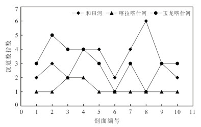
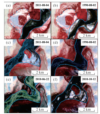

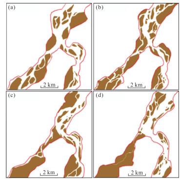
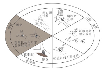


2023, 48(1): 376-384.
doi: 10.3799/dqkx.2022.010
Abstract:
Analysis of thiotungstates in natural water is of great importance for systematically investigating the environmental geochemistry of tungsten. In this paper, a method based on a system combining reversed-phase ion pair chromatography and inductively coupled plasma mass spectrometry is proposed to simultaneously determine the concentrations of tungstate (WO42‒) and four thiotungstates (including WO3S2‒, WO2S22‒, WOS32‒ and WS42‒). The speciation analyses of these five tungsten compounds were performed by a high-resolution electrospray ionization mass spectrometer. Sulfide-rich geothermal water samples were snap frozen at -20 ℃ and transported to the laboratory. After thawing under anaerobic conditions, the five tungsten compounds were separated and determined within 30 min using optimized chromatographic and mass spectrometric conditions. The working curves were established using tungstate as the standards for the other tungsten compounds, with good linear relation (correlation coefficient R2 > 0.999) in the concentration range of 0.001-20 mg/L. The limits of detection (LOD) for tungstate, monothiotungstate, dithiotungstate, trithiotungstate and tetrathiotungstate were 0.82 µg/L, 0.34 µg/L, 0.22 µg/L, 0.79 µg/L and 0.62 µg/L, respectively. This method has the advantages of high sensitivity and good reproducibility, and provides an effective way for the detection and research of thiotungstates in natural water.
Analysis of thiotungstates in natural water is of great importance for systematically investigating the environmental geochemistry of tungsten. In this paper, a method based on a system combining reversed-phase ion pair chromatography and inductively coupled plasma mass spectrometry is proposed to simultaneously determine the concentrations of tungstate (WO42‒) and four thiotungstates (including WO3S2‒, WO2S22‒, WOS32‒ and WS42‒). The speciation analyses of these five tungsten compounds were performed by a high-resolution electrospray ionization mass spectrometer. Sulfide-rich geothermal water samples were snap frozen at -20 ℃ and transported to the laboratory. After thawing under anaerobic conditions, the five tungsten compounds were separated and determined within 30 min using optimized chromatographic and mass spectrometric conditions. The working curves were established using tungstate as the standards for the other tungsten compounds, with good linear relation (correlation coefficient R2 > 0.999) in the concentration range of 0.001-20 mg/L. The limits of detection (LOD) for tungstate, monothiotungstate, dithiotungstate, trithiotungstate and tetrathiotungstate were 0.82 µg/L, 0.34 µg/L, 0.22 µg/L, 0.79 µg/L and 0.62 µg/L, respectively. This method has the advantages of high sensitivity and good reproducibility, and provides an effective way for the detection and research of thiotungstates in natural water.


