2023 Vol. 48, No. 2
Display Method:
2023, 48(2): 385-397.
doi: 10.3799/dqkx.2022.151
 PDF 18551KB
Abstract:
With the increasing exploration degree of shallow formations (mainly Meogene) in offshore China, middle⁃deep buried formations (mainly Paleogene), especially the Eocene and Oligocene, is one of the important exploration targets in the future. However, there is still a lack of systematic research on the characteristics and dissolution of the middle⁃deep clastic reservoirs in offshore China. In this paper, Liaozhong sag, Xihu sag and Baiyun sag were taken as target areas. Based on a large number of new drilling, physical property data and various tests, the petrological characteristics, physical property and pore types of paleogene clastic reservoirs in offshore China were systematically elucidated, and their dissolution regularities were analyzed and summarized. The results show that the Paleogene sandstone reservoirs in offshore China were mainly composed of feldspar⁃lithic sandstone or lithic⁃feldspar sandstone. Different structures and lithology varied significantly in the same sag, and the content of quartz and lithic varied slightly in different layers. The reservoir was mainly medium⁃low porosity and low permeability, and medium⁃high porosity and permeability reservoirs are mainly developed in the first and second member of Shahejie Formation and the upper member of Zhuhai Formation of Baiyun Sag. The primary pores only developed in the north of Pinghu slope in Xihu Sag, the fourth member of Shahejie Formation in Liaozhong Sag and the upper member of Zhuhai Formation in Baiyun Sag. The dissolution of feldspar, calcite and part of fragments was mainly by acidic fluid. The dissolution in Liaozhong Sag varied markedly between different formations, with significant dissolution in sandstone reservoirs controlled by shallow⁃buried deep volcanic host rocks and medium⁃deep rigid host rocks, while the West Slope of the Xihu Sag showed early succession calcite dissolution in a section of the Pinghu Formation and three sections of the Pinghu Formation, and the Baiyun Sag dissolution was mainly kaolinization of feldspar and illite lithification of kaolinite.This study aims to provide reference for exploration and development of paleogene clastic reservoirs in offshore China.
With the increasing exploration degree of shallow formations (mainly Meogene) in offshore China, middle⁃deep buried formations (mainly Paleogene), especially the Eocene and Oligocene, is one of the important exploration targets in the future. However, there is still a lack of systematic research on the characteristics and dissolution of the middle⁃deep clastic reservoirs in offshore China. In this paper, Liaozhong sag, Xihu sag and Baiyun sag were taken as target areas. Based on a large number of new drilling, physical property data and various tests, the petrological characteristics, physical property and pore types of paleogene clastic reservoirs in offshore China were systematically elucidated, and their dissolution regularities were analyzed and summarized. The results show that the Paleogene sandstone reservoirs in offshore China were mainly composed of feldspar⁃lithic sandstone or lithic⁃feldspar sandstone. Different structures and lithology varied significantly in the same sag, and the content of quartz and lithic varied slightly in different layers. The reservoir was mainly medium⁃low porosity and low permeability, and medium⁃high porosity and permeability reservoirs are mainly developed in the first and second member of Shahejie Formation and the upper member of Zhuhai Formation of Baiyun Sag. The primary pores only developed in the north of Pinghu slope in Xihu Sag, the fourth member of Shahejie Formation in Liaozhong Sag and the upper member of Zhuhai Formation in Baiyun Sag. The dissolution of feldspar, calcite and part of fragments was mainly by acidic fluid. The dissolution in Liaozhong Sag varied markedly between different formations, with significant dissolution in sandstone reservoirs controlled by shallow⁃buried deep volcanic host rocks and medium⁃deep rigid host rocks, while the West Slope of the Xihu Sag showed early succession calcite dissolution in a section of the Pinghu Formation and three sections of the Pinghu Formation, and the Baiyun Sag dissolution was mainly kaolinization of feldspar and illite lithification of kaolinite.This study aims to provide reference for exploration and development of paleogene clastic reservoirs in offshore China.


2023, 48(2): 398-412.
doi: 10.3799/dqkx.2022.414
Abstract:
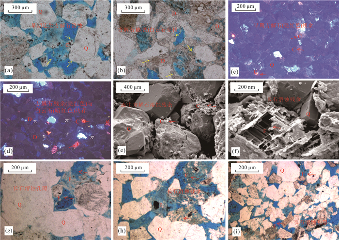
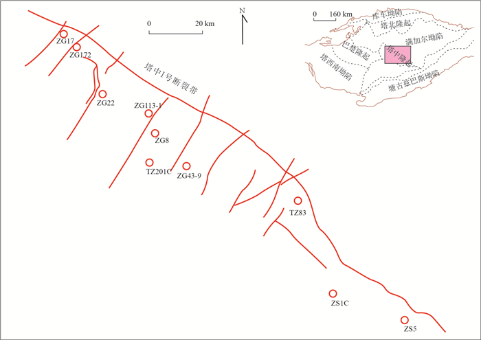
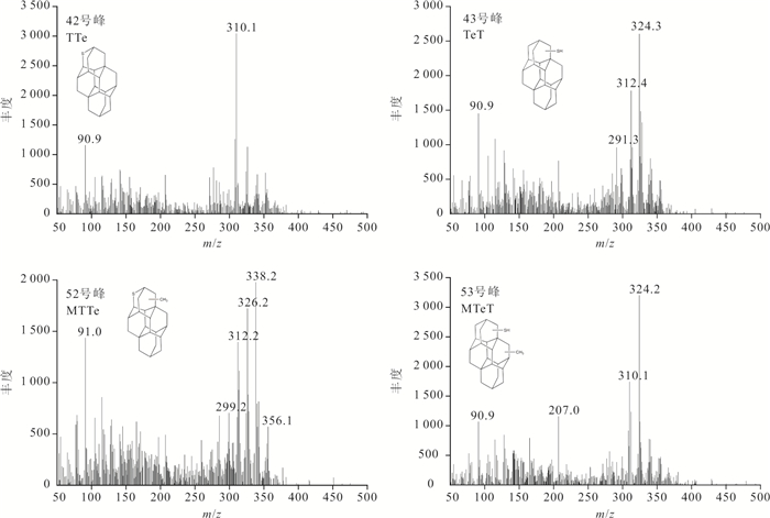
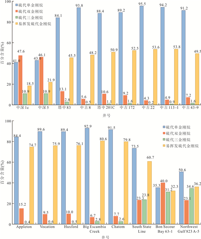
Thiadiamondoids are commonly considered to be typical products of thermochemical sulfate reduction (TSR). Thiadiamondoids have been found in high quantities in crude oil in the Tarim Basin. By using a silver nitrate impregnated silica gel column, organic sulfur compounds (OSC) were separated from the marine oil samples from the Tarim Basin. By using GC⁃MS analysis, 76 compounds were identified in OSC fraction, including all lower thiadiamondoids (1⁃, 2⁃, and 3⁃cage thiadiamondoids), part of higher thiadiamondoids (4⁃, 5⁃, and 6⁃cage thiadiamondoids), and diamondoidthiols. C0⁃C2 thiaadamantanes (high volatile thiadiamondoids) comprise nearly half of the total thiaadamantanes in most of the samples. ZS1C and ZS5 samples are special compared with the rest of the samples, in which high volatile thiadiamondoids occupies only about 20% relative abundance. the ratios of thiaadamantanes: thiadiamantanes: thiatriamantanes of these two samples are approximately 4∶4∶1, while those of the other samples are generally 8∶1∶0. Thiadiamondoids can serve as a quantitative indicator of the strength of TSR. The oil sample has migrated, as evidenced by the high ratio of thiaadamantanes and the high relative abundance of high volatile thiadiamondoids. The content differences of thiadiamondoids can effectively indicate the intensity of TSR and to judge whether TSR is in⁃situ, and the OSC component of the TSR product is also present, along with a significant quantity of H2S gas. It can also provide guidance for the prediction of the distribution and genesis of hydrogen sulfide and petroleum exploration and exploitation decisions in deep strata.
Thiadiamondoids are commonly considered to be typical products of thermochemical sulfate reduction (TSR). Thiadiamondoids have been found in high quantities in crude oil in the Tarim Basin. By using a silver nitrate impregnated silica gel column, organic sulfur compounds (OSC) were separated from the marine oil samples from the Tarim Basin. By using GC⁃MS analysis, 76 compounds were identified in OSC fraction, including all lower thiadiamondoids (1⁃, 2⁃, and 3⁃cage thiadiamondoids), part of higher thiadiamondoids (4⁃, 5⁃, and 6⁃cage thiadiamondoids), and diamondoidthiols. C0⁃C2 thiaadamantanes (high volatile thiadiamondoids) comprise nearly half of the total thiaadamantanes in most of the samples. ZS1C and ZS5 samples are special compared with the rest of the samples, in which high volatile thiadiamondoids occupies only about 20% relative abundance. the ratios of thiaadamantanes: thiadiamantanes: thiatriamantanes of these two samples are approximately 4∶4∶1, while those of the other samples are generally 8∶1∶0. Thiadiamondoids can serve as a quantitative indicator of the strength of TSR. The oil sample has migrated, as evidenced by the high ratio of thiaadamantanes and the high relative abundance of high volatile thiadiamondoids. The content differences of thiadiamondoids can effectively indicate the intensity of TSR and to judge whether TSR is in⁃situ, and the OSC component of the TSR product is also present, along with a significant quantity of H2S gas. It can also provide guidance for the prediction of the distribution and genesis of hydrogen sulfide and petroleum exploration and exploitation decisions in deep strata.


2023, 48(2): 413-428.
doi: 10.3799/dqkx.2022.353
Abstract:
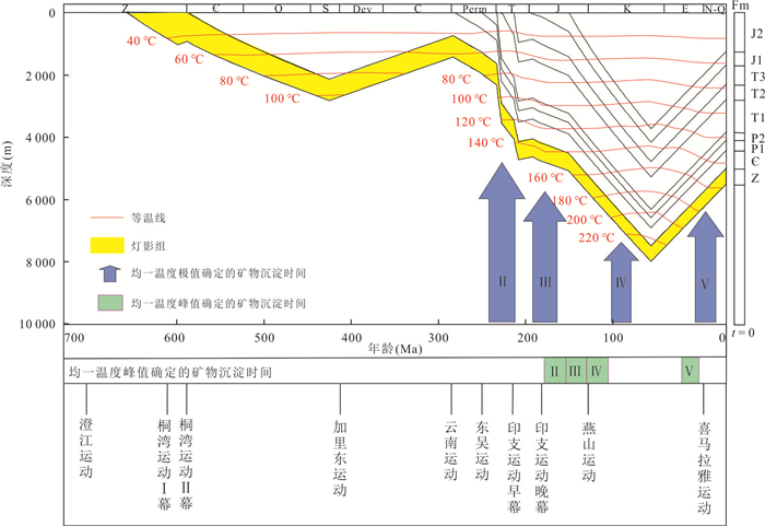
Complex geological evolution often leads to re⁃equilibration of fluid inclusions in deep carbonate reservoirs, and correctly identifying re⁃equilibration is of great significance to accurately explain paleo⁃fluid evolution.In this paper, taking the dolostone reservoir of Sinian Dengying Formation in Anyue gas field in Sichuan Basin, China as an example, the characteristics and types of re⁃equilibration are identified by petrography, Raman spectroscopy and micro⁃thermometry combined with the history of tectonic evolution, and original trapping conditions of each stage fluid inclusions are determined by PVT simulation based on the maxima or minima homogenization temperature of re⁃equilibrated fluid inclusions. The results show that fluid inclusions indolomi tes at stage Ⅱ, Ⅲ and Ⅳ are deformed by decrepitation, and fluid inclusions in calcite at stage Ⅴ are stretched, while re⁃equilibration characteristics of fluid inclusions in quartz at stage Ⅳ are not obvious. Re⁃equilibration of fluid inclusions in dolomites at stage Ⅱ and Ⅲ are in the process of burying and temperature increasing, while re⁃equilibration of fluid inclusions in dolomites at stage Ⅳ and in calcite at stage Ⅴ are in the process of uplift and temperature reducing.The trapping pressure and trapping temperature of fluid inclusions increase from stage Ⅱ to stage Ⅳ, reaching the peak of temperature and pressure at stage Ⅳ, while the trapping pressure and trapping temperature of fluid inclusions in calcite at stage Ⅴ are lower than those at stage Ⅳ. Combining trapping conditions and burial history can accurately determine the formation age of minerals at different diagenetic sequence, and the results can be compared with data from isotopic dating.
Complex geological evolution often leads to re⁃equilibration of fluid inclusions in deep carbonate reservoirs, and correctly identifying re⁃equilibration is of great significance to accurately explain paleo⁃fluid evolution.In this paper, taking the dolostone reservoir of Sinian Dengying Formation in Anyue gas field in Sichuan Basin, China as an example, the characteristics and types of re⁃equilibration are identified by petrography, Raman spectroscopy and micro⁃thermometry combined with the history of tectonic evolution, and original trapping conditions of each stage fluid inclusions are determined by PVT simulation based on the maxima or minima homogenization temperature of re⁃equilibrated fluid inclusions. The results show that fluid inclusions indolomi tes at stage Ⅱ, Ⅲ and Ⅳ are deformed by decrepitation, and fluid inclusions in calcite at stage Ⅴ are stretched, while re⁃equilibration characteristics of fluid inclusions in quartz at stage Ⅳ are not obvious. Re⁃equilibration of fluid inclusions in dolomites at stage Ⅱ and Ⅲ are in the process of burying and temperature increasing, while re⁃equilibration of fluid inclusions in dolomites at stage Ⅳ and in calcite at stage Ⅴ are in the process of uplift and temperature reducing.The trapping pressure and trapping temperature of fluid inclusions increase from stage Ⅱ to stage Ⅳ, reaching the peak of temperature and pressure at stage Ⅳ, while the trapping pressure and trapping temperature of fluid inclusions in calcite at stage Ⅴ are lower than those at stage Ⅳ. Combining trapping conditions and burial history can accurately determine the formation age of minerals at different diagenetic sequence, and the results can be compared with data from isotopic dating.


2023, 48(2): 429-438.
doi: 10.3799/dqkx.2022.399
Abstract:
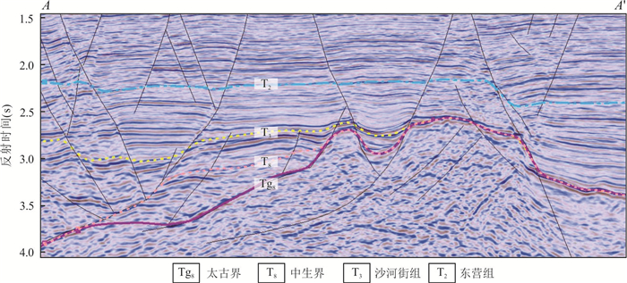
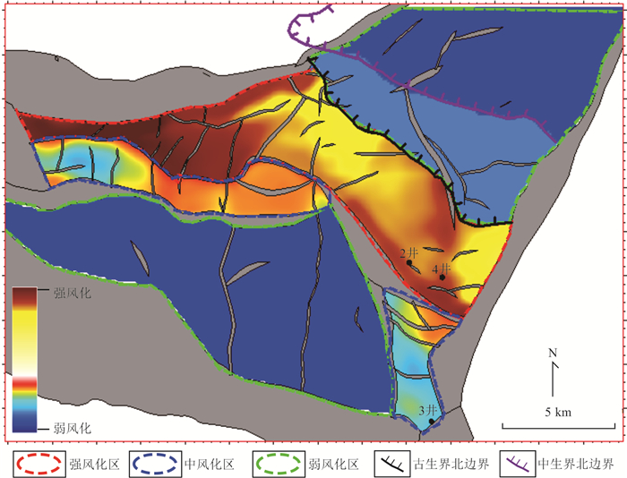
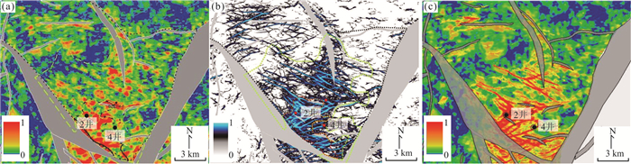
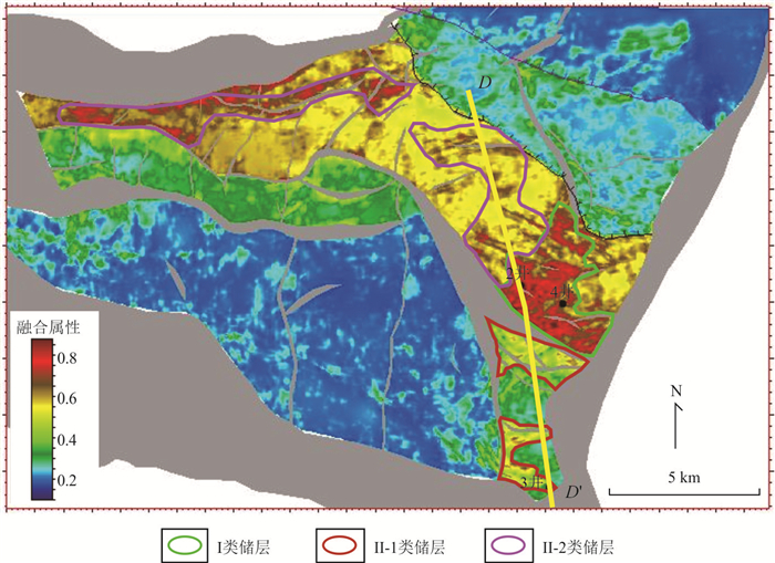
Archean buried⁃hill reservoir in BZ26⁃6, Bohai Bay is controlled by ancient landform and faults simultaneously. In order for reservoir evaluation and reserve production, we propose a fault⁃landform double controlledArchean buried⁃hill reservoir integrated prediction method. The composition of the overlying strata above the Archean buriedhill controls the weathering degree.Via restoration of ancient landform, we achieve reservoir plane division considering the weathering degree. Near east⁃west high⁃angle faults activated in Indosinian period and the normal fault continuously activated among Indosinian, Yanshanian and Himalayan periods control the fracture development, and we exploit the Radon transform and ant tracking methods to predict the favorable area of the fracture.In final, using the prediction of the weathering degree as low⁃frequency information, and the prediction of the fracture as high⁃frequency information, we exploiting the wavelet transform method to achieve the attribute fusion. Based on the fused attribute, the reservoir is classified as type Ⅰ, type Ⅱ⁃1 and type Ⅱ⁃2. The reservoir of type Ⅰ has the best quality, both the weathering degree and fracture development are relatively well, the reservoir of type Ⅱ⁃1 and Ⅱ⁃2 have relatively good quality, either weathering degree or fracture development is relatively well. The reservoir classification is coincided with the well logs and production test data, and helps to establish the reserve production strategy. It illustrates that exploiting the main controlling factors of weathering and fracture to guide seismic reservoir prediction, and using the attribute fusion to merge the results has a certain degree of practical significance.
Archean buried⁃hill reservoir in BZ26⁃6, Bohai Bay is controlled by ancient landform and faults simultaneously. In order for reservoir evaluation and reserve production, we propose a fault⁃landform double controlledArchean buried⁃hill reservoir integrated prediction method. The composition of the overlying strata above the Archean buriedhill controls the weathering degree.Via restoration of ancient landform, we achieve reservoir plane division considering the weathering degree. Near east⁃west high⁃angle faults activated in Indosinian period and the normal fault continuously activated among Indosinian, Yanshanian and Himalayan periods control the fracture development, and we exploit the Radon transform and ant tracking methods to predict the favorable area of the fracture.In final, using the prediction of the weathering degree as low⁃frequency information, and the prediction of the fracture as high⁃frequency information, we exploiting the wavelet transform method to achieve the attribute fusion. Based on the fused attribute, the reservoir is classified as type Ⅰ, type Ⅱ⁃1 and type Ⅱ⁃2. The reservoir of type Ⅰ has the best quality, both the weathering degree and fracture development are relatively well, the reservoir of type Ⅱ⁃1 and Ⅱ⁃2 have relatively good quality, either weathering degree or fracture development is relatively well. The reservoir classification is coincided with the well logs and production test data, and helps to establish the reserve production strategy. It illustrates that exploiting the main controlling factors of weathering and fracture to guide seismic reservoir prediction, and using the attribute fusion to merge the results has a certain degree of practical significance.


2023, 48(2): 439-450.
doi: 10.3799/dqkx.2022.456
Abstract:
The distribution of source⁃rock and main controlling factors of gas accumulation are vague in baodao sag, which restricts exploration breakthroughs. Comprehensive application of structural analysis、hydrocarbon source identification, source⁃sink system and comprehensive analysis techniques for accumulation, the main hydrocarbon supply kitchen、favorable reservoir⁃seal layer as well as main controlling factors of play under the control of differential structural evolution in baodao sag have been identified. The research shows that baodao sag belongs an "atypical" double fault during early oligocene, Yacheng formation in the fault terrace belts is thick, respectively forming two depression groups in the south and north; the northern depression groups mainly controlled by the early NE trending faults, result in multiple transition fault terrace belts are formed; NE⁃trending structural transition belts and low uplift controls the distribution of paleogene fan delta, delta sandstone as well as terrigenous marine source rock, thus becomes the main place for natural gas accumulation. Based on the analysis of natural gas migration and accumulation conditions under the control of different tectonic styles, two accumulation models are established, namely "oligocene near⁃source high efficiency accumulation type in transition fault terrace belts" and "miocene submarine fan limited accumulation type in depression zone", and sug"oligocene delta & structural⁃lithologic composite trap" on the transform fault terrace belts t are exploration direction of large gas fields.
The distribution of source⁃rock and main controlling factors of gas accumulation are vague in baodao sag, which restricts exploration breakthroughs. Comprehensive application of structural analysis、hydrocarbon source identification, source⁃sink system and comprehensive analysis techniques for accumulation, the main hydrocarbon supply kitchen、favorable reservoir⁃seal layer as well as main controlling factors of play under the control of differential structural evolution in baodao sag have been identified. The research shows that baodao sag belongs an "atypical" double fault during early oligocene, Yacheng formation in the fault terrace belts is thick, respectively forming two depression groups in the south and north; the northern depression groups mainly controlled by the early NE trending faults, result in multiple transition fault terrace belts are formed; NE⁃trending structural transition belts and low uplift controls the distribution of paleogene fan delta, delta sandstone as well as terrigenous marine source rock, thus becomes the main place for natural gas accumulation. Based on the analysis of natural gas migration and accumulation conditions under the control of different tectonic styles, two accumulation models are established, namely "oligocene near⁃source high efficiency accumulation type in transition fault terrace belts" and "miocene submarine fan limited accumulation type in depression zone", and sug"oligocene delta & structural⁃lithologic composite trap" on the transform fault terrace belts t are exploration direction of large gas fields.


2023, 48(2): 451-464.
doi: 10.3799/dqkx.2022.487
Abstract:
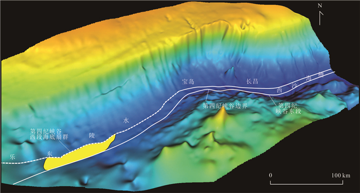
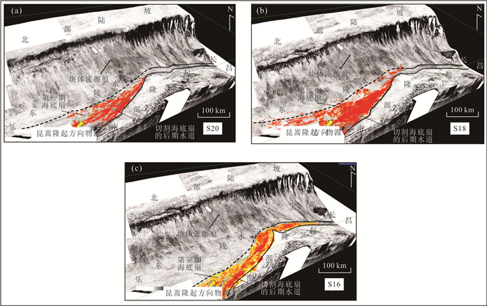
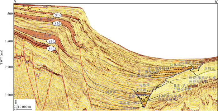
Based on the drilling data and new high⁃quality seismic data of the Central Canyon in Qiongdongnan Basin, the morphology, internal composition, sedimentary evolution process, and main controlling factors of the Quaternary Central Canyon System are systematically studied. The results indicate that the Central Canyon System went through 3 stages of evolution: the erosion and filling stage in the early Upper Miocene(Ⅰstage), the calm filling stage in the early Pliocene(Ⅱstage), the rejuvenation stage in early Quaternary(Ⅲ stage), and the evolution of the Canyon System was jointly controlled by tectonic activity and source supply. The negative paleogeomorphy and provenance supply that controlled the formation of the Central Canyon System in the first two stages still existed in the western segment of the Quaternary canyon. The early multi⁃provenance system in the western segment changed to the single provenance of the Qiupenhe River in the Con Son Swell in the Quaternary, and the provenance supply was sufficient. The progradational continental slope controlled the semi⁃restricted negative landform and sandy deposition to migrate gradually to the southeast, and the Canyon was filled up in the early Quaternary (S14). Under the guidance of this understanding, three⁃stage semi⁃restricted⁃scale submarine fan groups in the shallow strata of the western segment of the Quaternary canyon are discovered for the first time. These submarine fan groups have superior conditions for reservoir formation and have the new hydrocarbon accumulation model of "shallow⁃deep dual hydrocarbon source supplying, multiple preferential pathways conducting, shallow gas hydrate sealing, submarine fan below the hydrate stable zone controlling accumulation", and are new fields of large⁃middle scale oilfield exploration with broad prospects.
Based on the drilling data and new high⁃quality seismic data of the Central Canyon in Qiongdongnan Basin, the morphology, internal composition, sedimentary evolution process, and main controlling factors of the Quaternary Central Canyon System are systematically studied. The results indicate that the Central Canyon System went through 3 stages of evolution: the erosion and filling stage in the early Upper Miocene(Ⅰstage), the calm filling stage in the early Pliocene(Ⅱstage), the rejuvenation stage in early Quaternary(Ⅲ stage), and the evolution of the Canyon System was jointly controlled by tectonic activity and source supply. The negative paleogeomorphy and provenance supply that controlled the formation of the Central Canyon System in the first two stages still existed in the western segment of the Quaternary canyon. The early multi⁃provenance system in the western segment changed to the single provenance of the Qiupenhe River in the Con Son Swell in the Quaternary, and the provenance supply was sufficient. The progradational continental slope controlled the semi⁃restricted negative landform and sandy deposition to migrate gradually to the southeast, and the Canyon was filled up in the early Quaternary (S14). Under the guidance of this understanding, three⁃stage semi⁃restricted⁃scale submarine fan groups in the shallow strata of the western segment of the Quaternary canyon are discovered for the first time. These submarine fan groups have superior conditions for reservoir formation and have the new hydrocarbon accumulation model of "shallow⁃deep dual hydrocarbon source supplying, multiple preferential pathways conducting, shallow gas hydrate sealing, submarine fan below the hydrate stable zone controlling accumulation", and are new fields of large⁃middle scale oilfield exploration with broad prospects.


2023, 48(2): 465-474.
doi: 10.3799/dqkx.2022.488
Abstract:
Due to the small number of exploration Wells in the deep⁃water area and the similar number of AVO types of different fluids, the derived hydrocarbon detection properties such as conventional P (fitting intercept), G (fitting gradient), P×G and P+G have been unable to effectively identify the fluid properties of the deep water area, so it is urgent to find a hydrocarbon detection method suitable for the effective reservoirs in this area. In fact, seismic waves will produce obvious absorption and attenuation phenomenon in the propagation process of underground strata, especially through the gas⁃bearing sandstone will produce low⁃frequency increase phenomenon, so the combined spectral decomposition and AVO technology is an effective way to solve the deep⁃water hydrocarbon detection. By using the peak amplitude and average amplitude, can better describe the difference of fluid properties change, can enhance the sensitivity of the deep⁃water gas identification, in deep⁃water turbidity reservoir hydrocarbon detection good application results, progress to improve the reliability of deep⁃water reservoir hydrocarbon detection, effectively reduce the solution of deep⁃water hydrocarbon detection.
Due to the small number of exploration Wells in the deep⁃water area and the similar number of AVO types of different fluids, the derived hydrocarbon detection properties such as conventional P (fitting intercept), G (fitting gradient), P×G and P+G have been unable to effectively identify the fluid properties of the deep water area, so it is urgent to find a hydrocarbon detection method suitable for the effective reservoirs in this area. In fact, seismic waves will produce obvious absorption and attenuation phenomenon in the propagation process of underground strata, especially through the gas⁃bearing sandstone will produce low⁃frequency increase phenomenon, so the combined spectral decomposition and AVO technology is an effective way to solve the deep⁃water hydrocarbon detection. By using the peak amplitude and average amplitude, can better describe the difference of fluid properties change, can enhance the sensitivity of the deep⁃water gas identification, in deep⁃water turbidity reservoir hydrocarbon detection good application results, progress to improve the reliability of deep⁃water reservoir hydrocarbon detection, effectively reduce the solution of deep⁃water hydrocarbon detection.


2023, 48(2): 475-487.
doi: 10.3799/dqkx.2022.299
Abstract:
In Bozhong 19⁃6 gas field, due to the different types of reservoir spaces, strong heterogeneity, and unclear of main controlling factor of productivity of buried⁃hill fractured reservoirs, which makes it difficult to predict the productivity. In order to solve this problem, the characteristics of buried⁃hill fractured reservoirs are analyzed based on core, logging, geological and other data. Additionally, based on the CT scan experiment, the fractures can be quantitatively characterized and a series of calculation methods of fracture parameters including fracture permeability are formed. As a result, the productivity prediction model for buried⁃hill fractured reservoirs is established and the problem of productivity prediction of buried⁃hill fractured reservoirs is solved. The research results show that the fracture permeability of buried⁃hill fractured reservoirs is mainly controlled by the length, width and connectivity of the fractures, and has no obvious relationship with the porosity. Then, the fracture permeability can be calculated from the difference between the total permeability obtained by Stoneley wave inversion and the matrix permeability. The relative errors of matrix permeability and total permeability calculations are respectively 28.50% and 15.56%. Based on the fracture permeability, fracture longitudinal connectivity and effective thickness of buried⁃hill fractured reservoirs, the productivity prediction model for buried⁃hill fractured reservoirs can be established in Bozhong 19⁃6 gas field. The accuracy of fracture permeability calculation result determines the reliability of productivity prediction result of buried⁃hill fractured reservoirs.
In Bozhong 19⁃6 gas field, due to the different types of reservoir spaces, strong heterogeneity, and unclear of main controlling factor of productivity of buried⁃hill fractured reservoirs, which makes it difficult to predict the productivity. In order to solve this problem, the characteristics of buried⁃hill fractured reservoirs are analyzed based on core, logging, geological and other data. Additionally, based on the CT scan experiment, the fractures can be quantitatively characterized and a series of calculation methods of fracture parameters including fracture permeability are formed. As a result, the productivity prediction model for buried⁃hill fractured reservoirs is established and the problem of productivity prediction of buried⁃hill fractured reservoirs is solved. The research results show that the fracture permeability of buried⁃hill fractured reservoirs is mainly controlled by the length, width and connectivity of the fractures, and has no obvious relationship with the porosity. Then, the fracture permeability can be calculated from the difference between the total permeability obtained by Stoneley wave inversion and the matrix permeability. The relative errors of matrix permeability and total permeability calculations are respectively 28.50% and 15.56%. Based on the fracture permeability, fracture longitudinal connectivity and effective thickness of buried⁃hill fractured reservoirs, the productivity prediction model for buried⁃hill fractured reservoirs can be established in Bozhong 19⁃6 gas field. The accuracy of fracture permeability calculation result determines the reliability of productivity prediction result of buried⁃hill fractured reservoirs.


2023, 48(2): 488-502.
doi: 10.3799/dqkx.2022.296
Abstract:
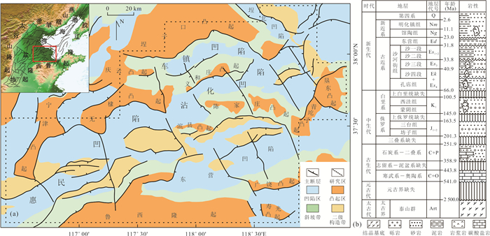
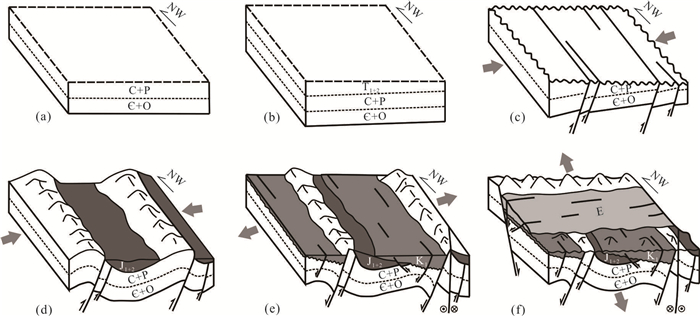
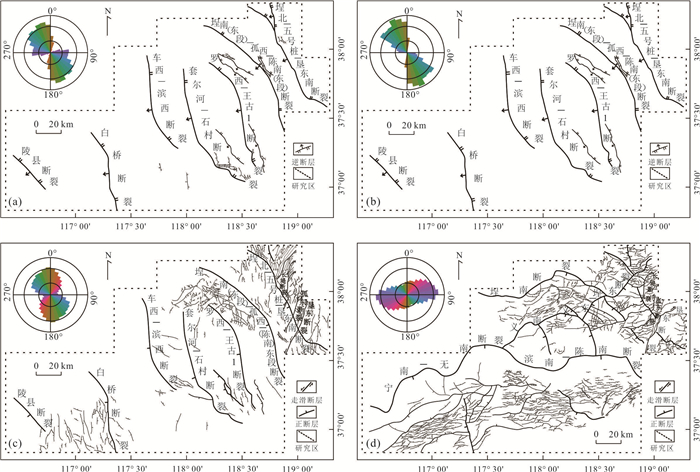
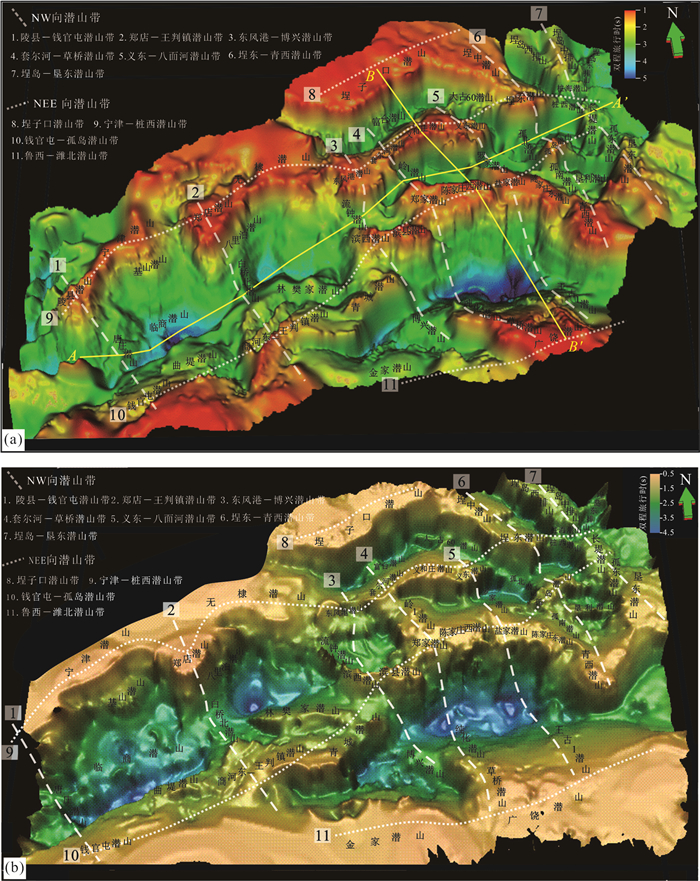
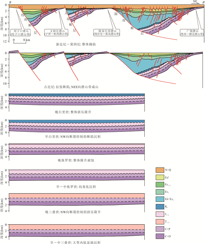
Based on the comprehensive application of the latest drilling, logging and seismic data and the structural evolution superposition relationship in the Jiyang Depression, this paper reveals the distribution law, genetic types and the internal structural differences of buried⁃hills, so as to provide guidance for hydrocarbon exploration. The results show that the vertical superposition of the basin structures controlled by the Mesozoic NW⁃trending inversion faults and the Cenozoic NEE⁃trending extensional faults influences the development of the NW⁃trending and NEE⁃trending buried⁃hill belts, forming the "seven⁃longitude and four⁃ latitude" distribution pattern of buried⁃hills in the Jiyang Depression. According to the development and evolution of buried⁃hills in the Jiyang Depression, they can be classified into three categories and seven sub categories. The differences in stratigraphic framework, structural style and burial history of various types of buried⁃hills lead to different hydrocarbon accumulation conditions such as oil and gas source, effective reservoirs and internal structures. NW⁃NEE superimposed hills have the best hydrocarbon conditions and should become key target areas of buried⁃hill oil reservoir exploration in the Jiyang Depression in the future.
Based on the comprehensive application of the latest drilling, logging and seismic data and the structural evolution superposition relationship in the Jiyang Depression, this paper reveals the distribution law, genetic types and the internal structural differences of buried⁃hills, so as to provide guidance for hydrocarbon exploration. The results show that the vertical superposition of the basin structures controlled by the Mesozoic NW⁃trending inversion faults and the Cenozoic NEE⁃trending extensional faults influences the development of the NW⁃trending and NEE⁃trending buried⁃hill belts, forming the "seven⁃longitude and four⁃ latitude" distribution pattern of buried⁃hills in the Jiyang Depression. According to the development and evolution of buried⁃hills in the Jiyang Depression, they can be classified into three categories and seven sub categories. The differences in stratigraphic framework, structural style and burial history of various types of buried⁃hills lead to different hydrocarbon accumulation conditions such as oil and gas source, effective reservoirs and internal structures. NW⁃NEE superimposed hills have the best hydrocarbon conditions and should become key target areas of buried⁃hill oil reservoir exploration in the Jiyang Depression in the future.


2023, 48(2): 503-516.
doi: 10.3799/dqkx.2022.497
Abstract:
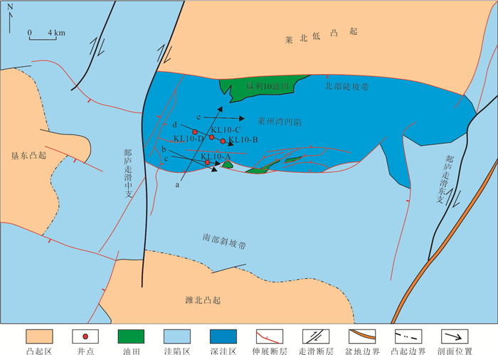
Based on the well⁃drilled, well logging and 3D seismic data, the sedimentary characteristics of sandbodies in the third member of Shahejie formation in Laizhouwan sag were analyzed, and the genesis and development model were discussed. The results show that the sandbodies in the early middle member of the third member of Shahejie formation in the study area are formed by sublacustrine fan deposits, which show channel type characteristics. The sublacustrine fan deposits can be subdivided into sedimentary microfacies types such as superimposed channel and its flanks, compound channel and its flanks, single channel and interchannel. Sublacustrine fan framework sand body is composed of superimposed channel and compound channel. The type and scale of the waterway from south to north are controlled by the degree of provenance and sand enrichment, the type of slope break zone of synsedimentary fault, and paleogeomorphology changes. The degree of provenance sand enrichment fundamentally determines the external shape of the sublacustrine fan. The type of slope break zone and paleogeomorphologic change of synsedimentary fault further control the location, channel size and type of the lake floor fan. Watercourse type lake⁃bottom fan is an important target for lithologic reservoir exploration because of the excellent hydrocarbon migration and accumulation conditions near oil source and good reservoir⁃cap assemblage.
Based on the well⁃drilled, well logging and 3D seismic data, the sedimentary characteristics of sandbodies in the third member of Shahejie formation in Laizhouwan sag were analyzed, and the genesis and development model were discussed. The results show that the sandbodies in the early middle member of the third member of Shahejie formation in the study area are formed by sublacustrine fan deposits, which show channel type characteristics. The sublacustrine fan deposits can be subdivided into sedimentary microfacies types such as superimposed channel and its flanks, compound channel and its flanks, single channel and interchannel. Sublacustrine fan framework sand body is composed of superimposed channel and compound channel. The type and scale of the waterway from south to north are controlled by the degree of provenance and sand enrichment, the type of slope break zone of synsedimentary fault, and paleogeomorphology changes. The degree of provenance sand enrichment fundamentally determines the external shape of the sublacustrine fan. The type of slope break zone and paleogeomorphologic change of synsedimentary fault further control the location, channel size and type of the lake floor fan. Watercourse type lake⁃bottom fan is an important target for lithologic reservoir exploration because of the excellent hydrocarbon migration and accumulation conditions near oil source and good reservoir⁃cap assemblage.


2023, 48(2): 517-532.
doi: 10.3799/dqkx.2023.030
Abstract:
The quantitative characterization of deep and ultra-deep hydrocarbon accumulation across multiple tectonic periods is one of the major sticking points in geoscience. The Dengying natural gas reservoirs of Upper Sinian in Central Sichuan are dominated by typical oil-cracking gas, and the hydrocarbon evolution has experienced a complex process from paleo-oil-reservoirs, paleo-gas reservoirs to today's gas reservoirs. The quantitative description of paleo-oil-reservoirs is the key and core to restore its hydrocarbon accumulation process. In this paper, the Dengying gas reservoirs of Upper Sinian in the North Slope of the central Sichuan paleo-uplift is selected as the research object, the solid bitumen is taken as the medium, based on core description, the solid bitumen is quantitatively evaluated in three dimensions from "point" (quantitative evaluation of solid bitumen by image-processing method), "line" (quantitative evaluation of solid bitumen by logging interpretation on multi-mineral inversion) to "plane" (quantitatively evaluate the plane distribution of solid bitumen), then quantitatively evaluated the paleo-oil-reservoirs and their resources by volume method, to provide support for the evaluation of natural gas exploration potential in the slope area from the perspective of hydrocarbon accumulation mechanism. The results show that: (1) Solid bitumen in the Dengying Formation mainly exists in the pore space in the state of semi-filling to full-filling. Generally, the solid bitumen content of the second member of the Dengying Formation is higher than that of the fourth member. Also, the solid bitumen content in the upper sub-member is slightly higher than that in the lower sub-member, no matter in the second member or the fourth; (2) The vertical and horizontal distribution of solid bitumen indicate that: in the vertical direction, the oil charging direction is mostly from top to bottom; while on the plane, there are two main directions for oil charging: from Deyang-Anyue rift trough to the inner side of the platform; lateral charging from the northern slope area to south, to the high part of the paleo-uplift; (3) The paleo-oil-reservoirs of Dengying Formation in the North Slope completed cracking earlier than the large-scale regional tectonic movement. Therefore, the content and distribution of solid bitumen in the reservoirs can be used to quantitatively describe the paleo-oil-reservoirs. The identification standard of paleo-oil-reservoirs is: the filling degree of solid bitumen in pore space is greater than 25% and the of solid bitumen content is greater than 2%; (4) Based on the distribution of mound and beach body on the platform-edge in the slope area, this study quantitatively depicted 5 reliable paleo-oil-reservoirs and 4 potential paleo-oil-reservoirs in North Slope of the central Sichuan Uplift. The scale of the paleo-oil-reservoirs obtained by volume method is about 177.25 × 10⁸ t, and a complete cracking can produce oil-cracking gas of about 109 893.94 × 10⁸ m3.
The quantitative characterization of deep and ultra-deep hydrocarbon accumulation across multiple tectonic periods is one of the major sticking points in geoscience. The Dengying natural gas reservoirs of Upper Sinian in Central Sichuan are dominated by typical oil-cracking gas, and the hydrocarbon evolution has experienced a complex process from paleo-oil-reservoirs, paleo-gas reservoirs to today's gas reservoirs. The quantitative description of paleo-oil-reservoirs is the key and core to restore its hydrocarbon accumulation process. In this paper, the Dengying gas reservoirs of Upper Sinian in the North Slope of the central Sichuan paleo-uplift is selected as the research object, the solid bitumen is taken as the medium, based on core description, the solid bitumen is quantitatively evaluated in three dimensions from "point" (quantitative evaluation of solid bitumen by image-processing method), "line" (quantitative evaluation of solid bitumen by logging interpretation on multi-mineral inversion) to "plane" (quantitatively evaluate the plane distribution of solid bitumen), then quantitatively evaluated the paleo-oil-reservoirs and their resources by volume method, to provide support for the evaluation of natural gas exploration potential in the slope area from the perspective of hydrocarbon accumulation mechanism. The results show that: (1) Solid bitumen in the Dengying Formation mainly exists in the pore space in the state of semi-filling to full-filling. Generally, the solid bitumen content of the second member of the Dengying Formation is higher than that of the fourth member. Also, the solid bitumen content in the upper sub-member is slightly higher than that in the lower sub-member, no matter in the second member or the fourth; (2) The vertical and horizontal distribution of solid bitumen indicate that: in the vertical direction, the oil charging direction is mostly from top to bottom; while on the plane, there are two main directions for oil charging: from Deyang-Anyue rift trough to the inner side of the platform; lateral charging from the northern slope area to south, to the high part of the paleo-uplift; (3) The paleo-oil-reservoirs of Dengying Formation in the North Slope completed cracking earlier than the large-scale regional tectonic movement. Therefore, the content and distribution of solid bitumen in the reservoirs can be used to quantitatively describe the paleo-oil-reservoirs. The identification standard of paleo-oil-reservoirs is: the filling degree of solid bitumen in pore space is greater than 25% and the of solid bitumen content is greater than 2%; (4) Based on the distribution of mound and beach body on the platform-edge in the slope area, this study quantitatively depicted 5 reliable paleo-oil-reservoirs and 4 potential paleo-oil-reservoirs in North Slope of the central Sichuan Uplift. The scale of the paleo-oil-reservoirs obtained by volume method is about 177.25 × 10⁸ t, and a complete cracking can produce oil-cracking gas of about 109 893.94 × 10⁸ m3.


2023, 48(2): 533-552.
doi: 10.3799/dqkx.2022.416
Abstract:
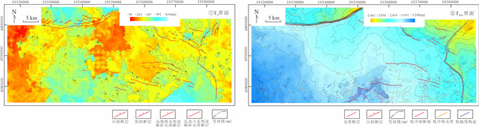
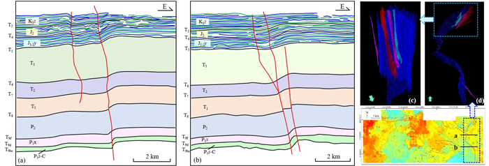
The nor-marine tight sandstone strata of upper Paleozoic contains rich hydrocarbon resources in Dongsheng gas field in Hangjinqi area, northern Ordos Basin. But the western, eastern, and northern margin mountains surround northern Ordos Basin which experienced multiphase, multi-direction and multi-attribute tectonization. The nor-marine tight sandstone strata of upper Paleozoic in Hangjinqi area exhibit large differences of structural effect, tight and strong heterogeneous reservoirs, complicated and specific hydrocarbon geological characteristics. Based on relationship analysis between northern basin and surrounding margin tectonic systems, stratigraphic contact relationship, 3D-seismic data, paleogeomorphic and tectonic chronology analysis, three main fault systems properties and formation time have been identified. (1)EW-NEE-trend faults are compressional fault at Late Jurassic and tensional fault at Late Cretaceous-early Himalayan epoch. (2)NW-NWW-trend faults are tensional strike slip fault at Late Cretaceous-early Himalayan epoch. (3)NE-SN-trend faults are compressional fault tensional fault at Early Cretaceous and tensional strike slip fault at Late Cretaceous-early Himalayan epoch. Three periods of tectonic deformation have been identified, which are Late Jurassic, Early Cretaceous and Late Cretaceous-early Himalayan epoch. Two critical tectonic periods have been identified which are the Early Yanshan epoch (late Jurassic-early Cretaceous) and the Later Yanshan epoch-early Himalayan epoch (later Cretaceous-early Eocene). The control effect of two critical tectonic periods on nor-marine tight gas accumulation express as different pattern, spatial extent, and results.
The nor-marine tight sandstone strata of upper Paleozoic contains rich hydrocarbon resources in Dongsheng gas field in Hangjinqi area, northern Ordos Basin. But the western, eastern, and northern margin mountains surround northern Ordos Basin which experienced multiphase, multi-direction and multi-attribute tectonization. The nor-marine tight sandstone strata of upper Paleozoic in Hangjinqi area exhibit large differences of structural effect, tight and strong heterogeneous reservoirs, complicated and specific hydrocarbon geological characteristics. Based on relationship analysis between northern basin and surrounding margin tectonic systems, stratigraphic contact relationship, 3D-seismic data, paleogeomorphic and tectonic chronology analysis, three main fault systems properties and formation time have been identified. (1)EW-NEE-trend faults are compressional fault at Late Jurassic and tensional fault at Late Cretaceous-early Himalayan epoch. (2)NW-NWW-trend faults are tensional strike slip fault at Late Cretaceous-early Himalayan epoch. (3)NE-SN-trend faults are compressional fault tensional fault at Early Cretaceous and tensional strike slip fault at Late Cretaceous-early Himalayan epoch. Three periods of tectonic deformation have been identified, which are Late Jurassic, Early Cretaceous and Late Cretaceous-early Himalayan epoch. Two critical tectonic periods have been identified which are the Early Yanshan epoch (late Jurassic-early Cretaceous) and the Later Yanshan epoch-early Himalayan epoch (later Cretaceous-early Eocene). The control effect of two critical tectonic periods on nor-marine tight gas accumulation express as different pattern, spatial extent, and results.


2023, 48(2): 553-567.
doi: 10.3799/dqkx.2022.346
Abstract:
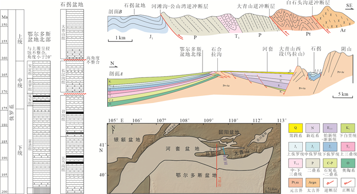
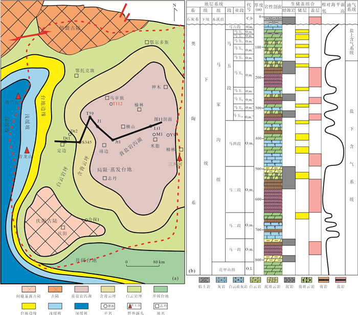
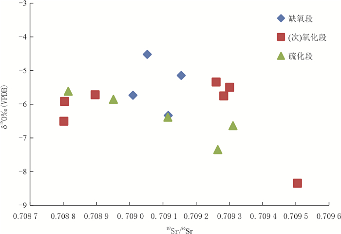
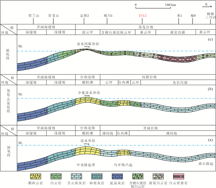
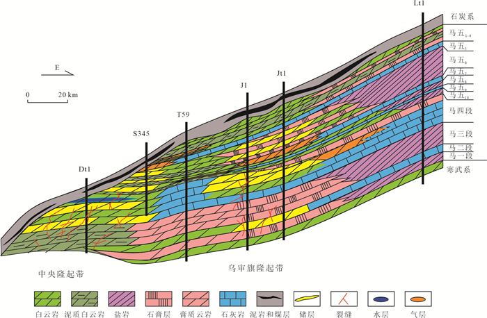
The carbonate gypsum salt rock combination contains 46% of the global carbonate oil and gas reserves and is an important oil and gas enrichment horizon. The Majiagou Formation of Ordovician in Ordos basin develops a large set of thick carbonate gypsum salt rock mixed deposits. At present, nearly trillion cubic meters of proved reserves have been found on salt. Is there exploration potential under salt and between salt? The restoration of the Paleoenvironment of the sedimentary system is the key. Based on the description of 400 m systematic coring of well T112 in the basin, combined with thin section identification, supporting analysis of trace elements, rare earth elements, carbon, oxygen, strontium isotopes and rock components, this paper restores the depositional environment of carbonate gypsum salt rock sedimentary system of Majiagou formation. According to the rise and fall of sea level and the change of water oxidation degree, the system can be divided into four sub environments: anoxic section, secondary oxidation section, oxidation section and sulfide section. With the aggravation of oxidation degree, the contents of trace elements such as U and Mo decrease, and the carbon oxygen strontium isotope is gradually positive. However, the oxygen content decreases sharply due to the sulfide section, and the isotopes of U, Mo and carbon oxygen strontium rise sharply, showing a frequent oscillation distribution with sea level. Based on the comparative analysis of paleoenvironment, TOC and porosity, the sulfide section and anoxic section are the most favorable hydrocarbon source rock development sections. Strong evaporation leads to water stratification and vulcanization, so that organic matter can be effectively preserved. Oxidation section and secondary oxidation section are favorable sections for reservoir development. The mound and beach bodies deposited by local uplift in the platform were frequently exposed, encountered quasi syngenetic dissolution and developed a large number of dissolution pores, which were effectively preserved after dolomitization. The source rock in the sulfide section and the dolomite reservoir in the oxidation section are interbedded in the longitudinal direction, and finger crossing in the plane, forming a good source-reservoir matching relationship. The three-dimensional reservoir network developed on Wushenqi uplift belt is a favorable area for Ordovician subsalt exploration in Ordos Basin.
The carbonate gypsum salt rock combination contains 46% of the global carbonate oil and gas reserves and is an important oil and gas enrichment horizon. The Majiagou Formation of Ordovician in Ordos basin develops a large set of thick carbonate gypsum salt rock mixed deposits. At present, nearly trillion cubic meters of proved reserves have been found on salt. Is there exploration potential under salt and between salt? The restoration of the Paleoenvironment of the sedimentary system is the key. Based on the description of 400 m systematic coring of well T112 in the basin, combined with thin section identification, supporting analysis of trace elements, rare earth elements, carbon, oxygen, strontium isotopes and rock components, this paper restores the depositional environment of carbonate gypsum salt rock sedimentary system of Majiagou formation. According to the rise and fall of sea level and the change of water oxidation degree, the system can be divided into four sub environments: anoxic section, secondary oxidation section, oxidation section and sulfide section. With the aggravation of oxidation degree, the contents of trace elements such as U and Mo decrease, and the carbon oxygen strontium isotope is gradually positive. However, the oxygen content decreases sharply due to the sulfide section, and the isotopes of U, Mo and carbon oxygen strontium rise sharply, showing a frequent oscillation distribution with sea level. Based on the comparative analysis of paleoenvironment, TOC and porosity, the sulfide section and anoxic section are the most favorable hydrocarbon source rock development sections. Strong evaporation leads to water stratification and vulcanization, so that organic matter can be effectively preserved. Oxidation section and secondary oxidation section are favorable sections for reservoir development. The mound and beach bodies deposited by local uplift in the platform were frequently exposed, encountered quasi syngenetic dissolution and developed a large number of dissolution pores, which were effectively preserved after dolomitization. The source rock in the sulfide section and the dolomite reservoir in the oxidation section are interbedded in the longitudinal direction, and finger crossing in the plane, forming a good source-reservoir matching relationship. The three-dimensional reservoir network developed on Wushenqi uplift belt is a favorable area for Ordovician subsalt exploration in Ordos Basin.


2023, 48(2): 568-581.
doi: 10.3799/dqkx.2022.370
Abstract:
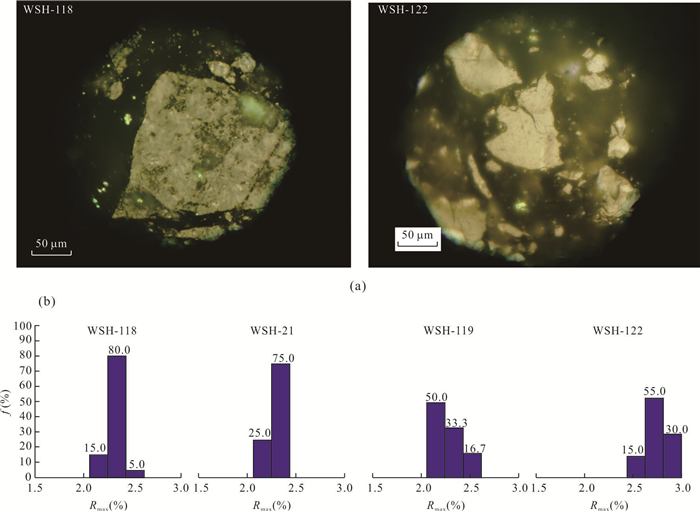
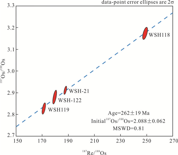
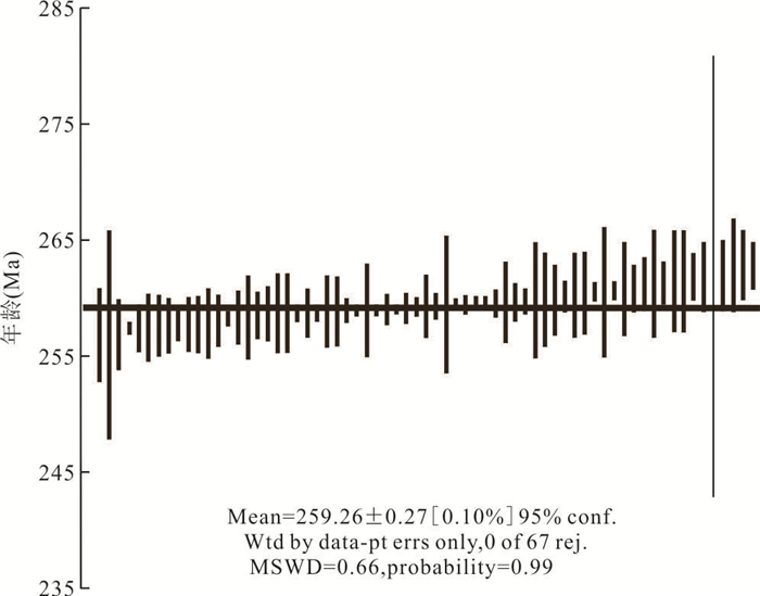
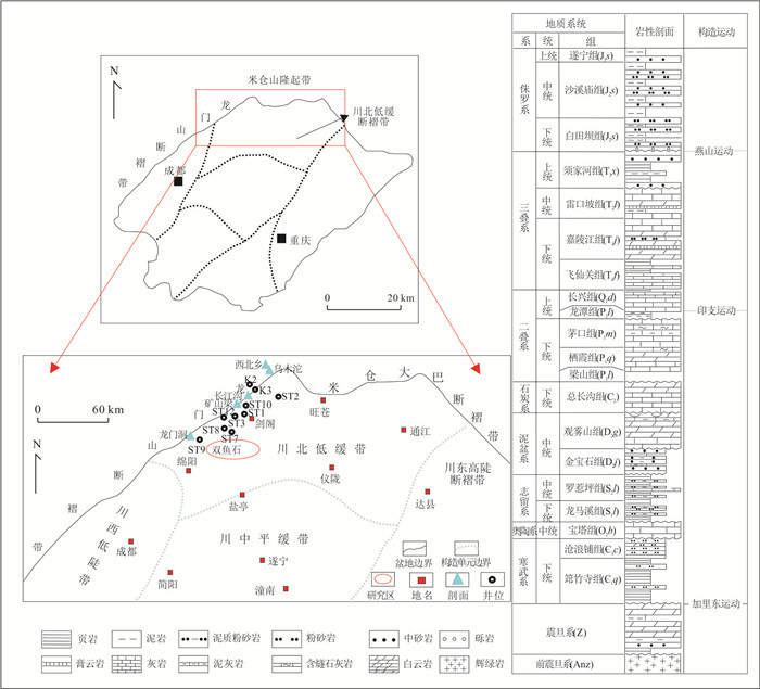
During the long process of basin formation and evolution, thermal events such as magma intrusion and deep high temperature fluid upwelling will lead to thermal anomalies and directly control the petroleum evolution. Located in the inter-mediate zone of Emeishan large igneous province in southwest Sichuan Basin, the Upper Neoproterozoic-Lower Cambrian Wusihe paleo-reservoir is an ideal object on revealing the relationship between volcanism and the petroleum evolution. Integrating the bitumen reflectance (Rb), elementary composition and Re-Os isotope dating in this work as well as the burial history, thermal histories and key timings related to Emeishan large igneous province from published works, the origin and evolution of bitumen were discussed and the relationship between petroleum accumulation and volcanic activity was established in the Wusihe area. The high bitumen reflectivity (~2.27−2.77) and low H/C atomic ratio (0.21−0.22) of the solid bitumen indicate they are high maturity pyrobitumen formed by thermal cracking. The Re-Os dates (~262 Ma) of the solid bitumen recorded timing of crude oil cracking and gas generation. In addition, the nearly same timing among the oil cracking, abnormal thermal event revealed by H1 Well (~260 Ma), as well as the Eruptive time for the Emeishan igneous province (257−263 Ma) indicate the petroleum evolution in the Wusihe reservoir is controlled by volcanic activities in the Emeishan igneous province during the same period, and the formation of the pyrobitumen and its Re-Os isotopic age are the responses to the activities of the Emeishan super mantle plume. This study provides a typical example for the study of petroleum evolution effect in Emeishan large igneous province.
During the long process of basin formation and evolution, thermal events such as magma intrusion and deep high temperature fluid upwelling will lead to thermal anomalies and directly control the petroleum evolution. Located in the inter-mediate zone of Emeishan large igneous province in southwest Sichuan Basin, the Upper Neoproterozoic-Lower Cambrian Wusihe paleo-reservoir is an ideal object on revealing the relationship between volcanism and the petroleum evolution. Integrating the bitumen reflectance (Rb), elementary composition and Re-Os isotope dating in this work as well as the burial history, thermal histories and key timings related to Emeishan large igneous province from published works, the origin and evolution of bitumen were discussed and the relationship between petroleum accumulation and volcanic activity was established in the Wusihe area. The high bitumen reflectivity (~2.27−2.77) and low H/C atomic ratio (0.21−0.22) of the solid bitumen indicate they are high maturity pyrobitumen formed by thermal cracking. The Re-Os dates (~262 Ma) of the solid bitumen recorded timing of crude oil cracking and gas generation. In addition, the nearly same timing among the oil cracking, abnormal thermal event revealed by H1 Well (~260 Ma), as well as the Eruptive time for the Emeishan igneous province (257−263 Ma) indicate the petroleum evolution in the Wusihe reservoir is controlled by volcanic activities in the Emeishan igneous province during the same period, and the formation of the pyrobitumen and its Re-Os isotopic age are the responses to the activities of the Emeishan super mantle plume. This study provides a typical example for the study of petroleum evolution effect in Emeishan large igneous province.


2023, 48(2): 582-595.
doi: 10.3799/dqkx.2022.441
Abstract:
The research on the hydrocarbon kitchen evolution of the Lower Cambrian Qiongzhusi Formation can provide important sustain for natural gas accumulation dynamics and exploration direction of the Sinian-Cambrian. Based on thermal history of the Sichuan Basin, the maturity and hydrocarbon generation histories of source rocks of the Qiongzhusi Formation were reproduced, the hydrocarbon kitchen evolution regularity was revealed, the coupling relationship between hydrocarbon generation processes, pale structure and large-scale reservoir formation was established, and the favorable zones of natural gas development in the Sinian-Cambrian were pointed out. The results show that the source rocks of the Qiongzhusi Formation experienced three stages of oil generation, including the Late Caledonian Movement Cycle, the Middle to Late Hercynian Movement Cycle and the Late Indosinian Movement Cycle to Early Yanshanian Movement Cycle; and four stages of gas generation, including the Late Caledonian Movement Cycle, the Middle to Late Hercynian Movement Cycle, the Late Hercynian Movement Cycle to Middle Indosinian Movement Cycle and the Middle Indosinian Movement Cycle to Early Yanshanian Movement Cycle. During the Late Caledonian Movement Cycle, two hydrocarbon kitchens were developed in northern and southern to southwestern Sichuan Basin, respectively, and the latter was the main hydrocarbon generation center; During the Late Caledonian Movement Cycle to the Late Hercynian Movement Cycle, hydrocarbon kitchen in northern Sichuan Basin migrated westward and was the main hydrocarbon generation center. The hydrocarbon generation intensity of hydrocarbon kitchen in southern to southwestern Sichuan Basin increased slightly and the kitchen did not migrate. During the Late Hercynian Movement Cycle to the Late Yanshanian Movement Cycle, a new hydrocarbon kitchen was developed in northwestern to central Sichuan Basin, which had large hydrocarbon intensity and wide area, and this stage was the most important hydrocarbon generation stage. The Sinian-Cambrian natural gas reservoirs were mainly formed by secondary cracking of crude oil. The space-time coupling of massive hydrocarbon generation, high-quality reservoirs in the platform margin and the high tectonic belt have laid a solid foundation for the large-scale accumulation. This research can provide basic parameters for gas exploration and exploitation. For the next exploration of the natural gas of the Sinian-Cambrian system, the high-quality reservoirs in the margin belt of the north central trough should be considered, and the shale gas exploration should be carried out at the positions where the three source rock kitchens are developed.
The research on the hydrocarbon kitchen evolution of the Lower Cambrian Qiongzhusi Formation can provide important sustain for natural gas accumulation dynamics and exploration direction of the Sinian-Cambrian. Based on thermal history of the Sichuan Basin, the maturity and hydrocarbon generation histories of source rocks of the Qiongzhusi Formation were reproduced, the hydrocarbon kitchen evolution regularity was revealed, the coupling relationship between hydrocarbon generation processes, pale structure and large-scale reservoir formation was established, and the favorable zones of natural gas development in the Sinian-Cambrian were pointed out. The results show that the source rocks of the Qiongzhusi Formation experienced three stages of oil generation, including the Late Caledonian Movement Cycle, the Middle to Late Hercynian Movement Cycle and the Late Indosinian Movement Cycle to Early Yanshanian Movement Cycle; and four stages of gas generation, including the Late Caledonian Movement Cycle, the Middle to Late Hercynian Movement Cycle, the Late Hercynian Movement Cycle to Middle Indosinian Movement Cycle and the Middle Indosinian Movement Cycle to Early Yanshanian Movement Cycle. During the Late Caledonian Movement Cycle, two hydrocarbon kitchens were developed in northern and southern to southwestern Sichuan Basin, respectively, and the latter was the main hydrocarbon generation center; During the Late Caledonian Movement Cycle to the Late Hercynian Movement Cycle, hydrocarbon kitchen in northern Sichuan Basin migrated westward and was the main hydrocarbon generation center. The hydrocarbon generation intensity of hydrocarbon kitchen in southern to southwestern Sichuan Basin increased slightly and the kitchen did not migrate. During the Late Hercynian Movement Cycle to the Late Yanshanian Movement Cycle, a new hydrocarbon kitchen was developed in northwestern to central Sichuan Basin, which had large hydrocarbon intensity and wide area, and this stage was the most important hydrocarbon generation stage. The Sinian-Cambrian natural gas reservoirs were mainly formed by secondary cracking of crude oil. The space-time coupling of massive hydrocarbon generation, high-quality reservoirs in the platform margin and the high tectonic belt have laid a solid foundation for the large-scale accumulation. This research can provide basic parameters for gas exploration and exploitation. For the next exploration of the natural gas of the Sinian-Cambrian system, the high-quality reservoirs in the margin belt of the north central trough should be considered, and the shale gas exploration should be carried out at the positions where the three source rock kitchens are developed.


2023, 48(2): 596-608.
doi: 10.3799/dqkx.2022.403
Abstract:
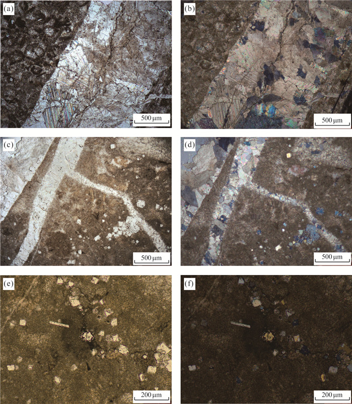
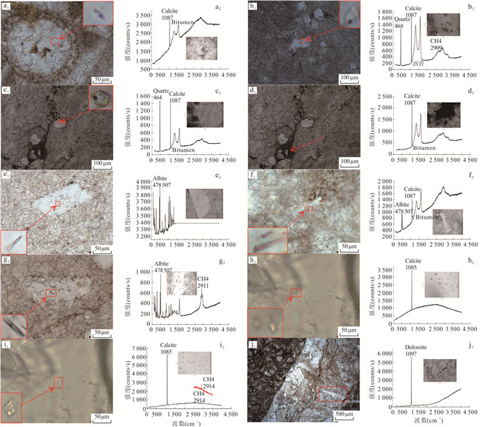
Based on drilling core observation, combined polarizing microscopic observation forthin section, cathodoluminescence and fluid inclusion analysis, this paper discusses hydrocarbon accumulation and fluid evolution of Qixia Formation in Shuangyushi structure in northwestern Sichuan. There sults show that the upper reservoir of Qixia Formation of Shuangyushi structure in northwest Sichuan is sparry cloud limestone, and its fillings of diagenetic mineral can be divided into four stages, including early fine crystalline calcite, recrystallized calcite, quartz and albite filled in early limestone holes, and dolomite and calcite filled in pore cracks. Combined with the characteristics of fluid inclusions in different diagenetic stages and burial history analysis, it is found that study area was settled and accepted deposition from Permian to Middle Triassic, recrystallized calcite was formed due to the increase of burial depth and hydrothermal action associated with Emei taphrogeny.The early⁃middle Triassic to middle Jurassic lower Cambrian source rocks reached the peak of oil generation, which made the first stage of oil charged into Qixia Formation reservoir. Then the middle and lower Permian source rocks reached the peak of oil generation in the Early Jurassic and Early Cretaceous, that is, the second stage of oil charging. Quartz and albite were formed due to the charging of silica⁃rich hydrothermal fluid. At the same time, due to the burial depth and the transformation of hydrothermal fluid, part of the crude oil cracked into bitumen, and the ancient gas reservoir began to form gradually. The Longmenshan area experienced continuous thrust deformation in the middle and late Mesozoic from late Yanshanian to Himalayan, structural fractures were filled with dolomite and calcite. Methane and asphalt inclusions were captured in the veincalcite, and the ancient gas reservoirs were adjusted accordingly, which indicated the characteristics of early accumulation and late adjustment.
Based on drilling core observation, combined polarizing microscopic observation forthin section, cathodoluminescence and fluid inclusion analysis, this paper discusses hydrocarbon accumulation and fluid evolution of Qixia Formation in Shuangyushi structure in northwestern Sichuan. There sults show that the upper reservoir of Qixia Formation of Shuangyushi structure in northwest Sichuan is sparry cloud limestone, and its fillings of diagenetic mineral can be divided into four stages, including early fine crystalline calcite, recrystallized calcite, quartz and albite filled in early limestone holes, and dolomite and calcite filled in pore cracks. Combined with the characteristics of fluid inclusions in different diagenetic stages and burial history analysis, it is found that study area was settled and accepted deposition from Permian to Middle Triassic, recrystallized calcite was formed due to the increase of burial depth and hydrothermal action associated with Emei taphrogeny.The early⁃middle Triassic to middle Jurassic lower Cambrian source rocks reached the peak of oil generation, which made the first stage of oil charged into Qixia Formation reservoir. Then the middle and lower Permian source rocks reached the peak of oil generation in the Early Jurassic and Early Cretaceous, that is, the second stage of oil charging. Quartz and albite were formed due to the charging of silica⁃rich hydrothermal fluid. At the same time, due to the burial depth and the transformation of hydrothermal fluid, part of the crude oil cracked into bitumen, and the ancient gas reservoir began to form gradually. The Longmenshan area experienced continuous thrust deformation in the middle and late Mesozoic from late Yanshanian to Himalayan, structural fractures were filled with dolomite and calcite. Methane and asphalt inclusions were captured in the veincalcite, and the ancient gas reservoirs were adjusted accordingly, which indicated the characteristics of early accumulation and late adjustment.


2023, 48(2): 609-620.
doi: 10.3799/dqkx.2022.364
Abstract:
The northwest of Sichuan Basin are the key region of deep oil and gas exploration. Changxing Formation Formation platform marginal reef-flat gas fields have been discovered around"Kaijiang-Liangping" deep-water trough. Recently, with the new discovery of oil and gas in the Maokou Formation under the oil and gas accumulation zone, the forming time and scope of the deep-water trough and its constraint on the favorable exploration zone of the Maokou Formation have become a new research hotspot. Based on several field outcrop sections and drilling data in northwest Sichuan Basin, we reconstructed lithofacies paleogeographic of Maokou Formation in detail, and revealed the differentiation of deep-water facies and platform facies in Middle-Late of Maokou Formation. The sedimentation in facies belt results in the zonal synergistic difference in strata thickness; We reconstructed the lithofacies paleogeography and described the structure-sedimentary differentiation model of the Middle-Late Maokou Formation. This study confirms that the forming time of Kaijiang-Liangping trough should be pushed forward to the late of Middle Permian. Generally speaking, the deep-water trough of Makou Formation spreads along the Guangyuan-Bazhong-Pingchang area, and the platform margins on both sides are the potential development area of a new large-scale oil and gas accumulation zone. The platform margin zone formed by the tectonic-sedimentary differentiation is the initial geomorphological inherited margin along deep water trough, with the characteristics of wide margin and thin shoal body. The structure of shoal facies is discontinuous accretion, which is in sharp contrast to the narrow margin and thick shoal pattern formed by continuous accretion or progradation of generated on the edge in Changxing Formation.
The northwest of Sichuan Basin are the key region of deep oil and gas exploration. Changxing Formation Formation platform marginal reef-flat gas fields have been discovered around"Kaijiang-Liangping" deep-water trough. Recently, with the new discovery of oil and gas in the Maokou Formation under the oil and gas accumulation zone, the forming time and scope of the deep-water trough and its constraint on the favorable exploration zone of the Maokou Formation have become a new research hotspot. Based on several field outcrop sections and drilling data in northwest Sichuan Basin, we reconstructed lithofacies paleogeographic of Maokou Formation in detail, and revealed the differentiation of deep-water facies and platform facies in Middle-Late of Maokou Formation. The sedimentation in facies belt results in the zonal synergistic difference in strata thickness; We reconstructed the lithofacies paleogeography and described the structure-sedimentary differentiation model of the Middle-Late Maokou Formation. This study confirms that the forming time of Kaijiang-Liangping trough should be pushed forward to the late of Middle Permian. Generally speaking, the deep-water trough of Makou Formation spreads along the Guangyuan-Bazhong-Pingchang area, and the platform margins on both sides are the potential development area of a new large-scale oil and gas accumulation zone. The platform margin zone formed by the tectonic-sedimentary differentiation is the initial geomorphological inherited margin along deep water trough, with the characteristics of wide margin and thin shoal body. The structure of shoal facies is discontinuous accretion, which is in sharp contrast to the narrow margin and thick shoal pattern formed by continuous accretion or progradation of generated on the edge in Changxing Formation.


2023, 48(2): 621-639.
doi: 10.3799/dqkx.2022.379
Abstract:
To clarify the favorable reservoir distribution, determine associated engineering technology, and improve the exploration efficiency in Dibei tight gas reservoir of Kuqa Depression, the in situ stress field prediction and fracture effectiveness evaluation were analyzed based on geomechanics method in this study. In addition, the efficiency of sweet spot drilling and fracturing stimulation were considered, and the directional wellbore trajectory was quantitatively optimized based on the integration of geology and engineering. The results show that: (1) the in situ stresses and natural fractures largely determine the quality and fracturing efficiency of deep tight gas reservoirs, affecting the productivity of gas wells; (2) the Dibei gas reservoir has strong heterogeneity, resulting in significantly differences in petrophysical characteristics, in situ stress and fracture effectiveness among wells. The distribution of fracture sweet spots in Dibei gas reservoir is discrete, and the difficulty of reservoir stimulation is greatly restricted by geological factors. (3) Natural fractures greatly control high-quality sweet spots of deep tight gas reservoirs, and they can reduce the difficulty of fracturing operations and improve fracturing stimulation efficiency; (4) Directional wells should penetrate more low-stress zones and natural fractures and fully match the direction of natural fractures and in situ stress to improve single-well production. The vertical well drilling mode has limitations in the efficient exploration of Dibei tight gas reservoirs. Directional wells can take into account the efficiency of sweet spot drilling and fracturing stimulation and have advantages in terms of drilling safety and stability.
To clarify the favorable reservoir distribution, determine associated engineering technology, and improve the exploration efficiency in Dibei tight gas reservoir of Kuqa Depression, the in situ stress field prediction and fracture effectiveness evaluation were analyzed based on geomechanics method in this study. In addition, the efficiency of sweet spot drilling and fracturing stimulation were considered, and the directional wellbore trajectory was quantitatively optimized based on the integration of geology and engineering. The results show that: (1) the in situ stresses and natural fractures largely determine the quality and fracturing efficiency of deep tight gas reservoirs, affecting the productivity of gas wells; (2) the Dibei gas reservoir has strong heterogeneity, resulting in significantly differences in petrophysical characteristics, in situ stress and fracture effectiveness among wells. The distribution of fracture sweet spots in Dibei gas reservoir is discrete, and the difficulty of reservoir stimulation is greatly restricted by geological factors. (3) Natural fractures greatly control high-quality sweet spots of deep tight gas reservoirs, and they can reduce the difficulty of fracturing operations and improve fracturing stimulation efficiency; (4) Directional wells should penetrate more low-stress zones and natural fractures and fully match the direction of natural fractures and in situ stress to improve single-well production. The vertical well drilling mode has limitations in the efficient exploration of Dibei tight gas reservoirs. Directional wells can take into account the efficiency of sweet spot drilling and fracturing stimulation and have advantages in terms of drilling safety and stability.


2023, 48(2): 640-656.
doi: 10.3799/dqkx.2022.371
Abstract:
The Kuqa Depression is an important natural gas exploration target area in the Tarim Basin. Although the gas-bearing layer from the lower Cretaceous in the Dabei-Keshen area is buried deeper than 7500 m, and the average lithologic tight porosity is 4.8%, the area is still getting high-yield industrial gas stream. Fractures developed in rock formations have become the key factor for high natural gas production. Therefore, using reasonable techniques to effectively express fractured atais the key to clarifying the development characteristics and spatial distribution off ractures in deep tight sandstone, and is the premise for the effective development off ractured gas reservoirs. The advantages of big data can be obtained by using 3D laser scanning. Using point data splicing, denoising, and cutting methods, directly identifying the effective fracture information in the point cloud data, and analyzing the identified fracture information in combination with the fracture data obtained from the field profile measurement are incredibly useful to establish a geological knowledge base of fracture information in the target area. Identifying the spatial extent of fracture development in the target area, the development law of fracture density, and the azimuthal distribution of fractures helps to determine the constraints for the later random simulation. Under the constraints of 3D laser scanning point cloud processing data, the fisher function using stochastic simulation technology can better represent the azimuthal deflection phenomenon between single fractures in the fracture development area, reflecting the random development characteristics of natural fractures. Using the fracture opening information, the Oda calculation method is used to calculate and analyze the seepage capacity of each fracture, and the influence of the fracture development area on the surrounding rock fluid seepage is quantitatively determined. The calculation results of the Kuqa River section in the Kuqa Depression show that the vadose zone caused by the fracture cluster on the right side can reach 3.1m in width and 2.6m in extension; The vadose zone of the fracture cluster in the middle area is 1.2m wide and the extension length is 1.4 m; The width of the fracture cluster vadose zone on the left is about 0.9m, and its extension length is only about 0.33m.Itisconsistentwithfielddata. It can be seen that the higher the density of fractures in the fracture cluster, the greater the impact on fluid vadose zone. The wider the width of the fluid vadose zone expansion in the fracture cluster, the scope of influence wider. This better expresses the characteristics of deep fractured tight gas reservoirs in Kuqa. It shows that the stochastic simulation technology of fractures based on laser scanning technology can truly express the three-dimensional spatial distribution of fractures and the contribution of luidflow through porous medium.
The Kuqa Depression is an important natural gas exploration target area in the Tarim Basin. Although the gas-bearing layer from the lower Cretaceous in the Dabei-Keshen area is buried deeper than 7500 m, and the average lithologic tight porosity is 4.8%, the area is still getting high-yield industrial gas stream. Fractures developed in rock formations have become the key factor for high natural gas production. Therefore, using reasonable techniques to effectively express fractured atais the key to clarifying the development characteristics and spatial distribution off ractures in deep tight sandstone, and is the premise for the effective development off ractured gas reservoirs. The advantages of big data can be obtained by using 3D laser scanning. Using point data splicing, denoising, and cutting methods, directly identifying the effective fracture information in the point cloud data, and analyzing the identified fracture information in combination with the fracture data obtained from the field profile measurement are incredibly useful to establish a geological knowledge base of fracture information in the target area. Identifying the spatial extent of fracture development in the target area, the development law of fracture density, and the azimuthal distribution of fractures helps to determine the constraints for the later random simulation. Under the constraints of 3D laser scanning point cloud processing data, the fisher function using stochastic simulation technology can better represent the azimuthal deflection phenomenon between single fractures in the fracture development area, reflecting the random development characteristics of natural fractures. Using the fracture opening information, the Oda calculation method is used to calculate and analyze the seepage capacity of each fracture, and the influence of the fracture development area on the surrounding rock fluid seepage is quantitatively determined. The calculation results of the Kuqa River section in the Kuqa Depression show that the vadose zone caused by the fracture cluster on the right side can reach 3.1m in width and 2.6m in extension; The vadose zone of the fracture cluster in the middle area is 1.2m wide and the extension length is 1.4 m; The width of the fracture cluster vadose zone on the left is about 0.9m, and its extension length is only about 0.33m.Itisconsistentwithfielddata. It can be seen that the higher the density of fractures in the fracture cluster, the greater the impact on fluid vadose zone. The wider the width of the fluid vadose zone expansion in the fracture cluster, the scope of influence wider. This better expresses the characteristics of deep fractured tight gas reservoirs in Kuqa. It shows that the stochastic simulation technology of fractures based on laser scanning technology can truly express the three-dimensional spatial distribution of fractures and the contribution of luidflow through porous medium.


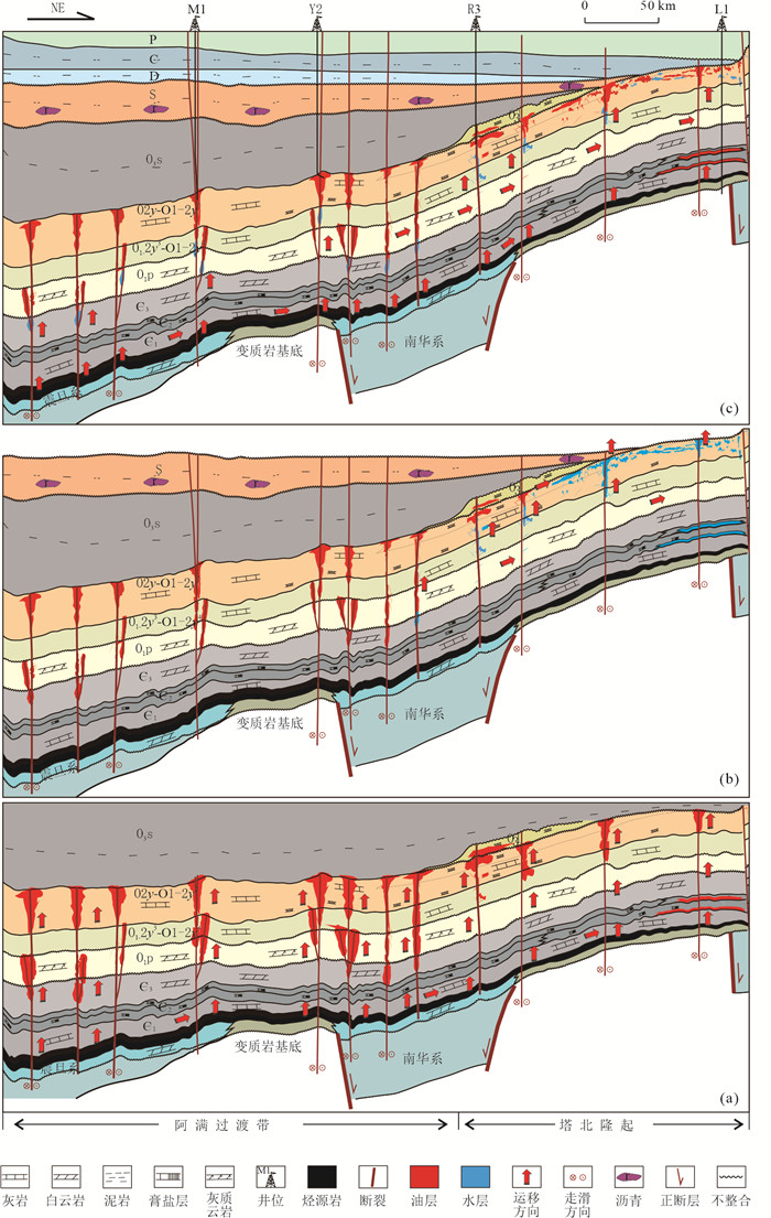
2023, 48(2): 657-672.
doi: 10.3799/dqkx.2022.445
Abstract:
The genetic model of the Ordovician multiphase oil and gas reservoirs in the south Tahe area is not well understood, the reservoir geochemistry, structural analysis, and geophysics have been used to conduct a deep study of the fluid properties, phase distribution, and origin of the Ordovician. It is discovered that the Ordovician reservoir fluid exhibits "four low and one high" features as well as the coexistence of dry gas and wet gas. Three different types of oil and gas reservoirs-condensate gas reservoir, volatile oil reservoir, and light oil reservoir-present the distribution pattern of east gas and west oil reservoirs, respectively. Only the nose bulge in the Hade block has experienced biodegradation, leaving most of the Ordovician crude oil in excellent condition. The crude oil has not experienced extensive cracking or TSR reaction and is of normal maturity. Early accumulation, vertical migration and accumulation, lateral adjustment, and sublevel enrichment are the characteristics of the primary Ordovician light oil reservoir in the main region. "Multi-source hydrocarbon supply, early oil and late gas, vertical charging and lateral migration and accumulation" are characteristics of the Ordovician condensate gas reservoir in the Yuke area's accumulation mechanism. It is determined that the Ordovician oil and gas preservation conditions are better in the south Tahe area, that there may still be major oil resources in the strike-slip fault zone in the southern depression area, and that there are significant natural gas resources in the platform margin zone of the Middle Cambrian Yijianfang Formation.
The genetic model of the Ordovician multiphase oil and gas reservoirs in the south Tahe area is not well understood, the reservoir geochemistry, structural analysis, and geophysics have been used to conduct a deep study of the fluid properties, phase distribution, and origin of the Ordovician. It is discovered that the Ordovician reservoir fluid exhibits "four low and one high" features as well as the coexistence of dry gas and wet gas. Three different types of oil and gas reservoirs-condensate gas reservoir, volatile oil reservoir, and light oil reservoir-present the distribution pattern of east gas and west oil reservoirs, respectively. Only the nose bulge in the Hade block has experienced biodegradation, leaving most of the Ordovician crude oil in excellent condition. The crude oil has not experienced extensive cracking or TSR reaction and is of normal maturity. Early accumulation, vertical migration and accumulation, lateral adjustment, and sublevel enrichment are the characteristics of the primary Ordovician light oil reservoir in the main region. "Multi-source hydrocarbon supply, early oil and late gas, vertical charging and lateral migration and accumulation" are characteristics of the Ordovician condensate gas reservoir in the Yuke area's accumulation mechanism. It is determined that the Ordovician oil and gas preservation conditions are better in the south Tahe area, that there may still be major oil resources in the strike-slip fault zone in the southern depression area, and that there are significant natural gas resources in the platform margin zone of the Middle Cambrian Yijianfang Formation.


2023, 48(2): 673-689.
doi: 10.3799/dqkx.2022.277
Abstract:
PenglaibaFormation of Tarim Basin has huge potential of hydrocarbon exploration, however, with unclear exploration target of either "fault dissolved geobody" or bedded massive dolomite reservoir. Based on the analysis ofreservoir features on the outcrops and drilling data, integrated with petrography and geochemistry examinations including C, O, Sr isotopes and laser ablation U⁃Pb datingetc., the origin and development of dolomite and the potential of bedded massive dolomite reservoir of Penglaiba Formation of Tarim Basin has been discussed, and furthermore, the exploration directionwas analyzed based ont the prediction of massive dolomite reservoir.Three aspects of results achieved include: (1) Penglaiba Formation hosts porous⁃vuggydolomite reservoir with the average porosity of 2.81% and the maximum porosity of 13.91%, with thepotential of constituting high quality reservoir; (2) It's proposed that the dolomite reservoir is made of mainly the burial dolomite formed by penecontemperanous dolomite modified and recrystallized by shallow burial dolomitization, whichis controlled by sedimentary faciesand could be developedmassively and bedded, mostly within the inner⁃ to middle ramp penecomtemporaneously dolomitized shoal; (3) It's predicted that south margin of Tabei uplift and north slope of Tazhong uplift are the favorable zone for the bedded massive dolomite reservoir, constituting worthwhile exploration targets.
PenglaibaFormation of Tarim Basin has huge potential of hydrocarbon exploration, however, with unclear exploration target of either "fault dissolved geobody" or bedded massive dolomite reservoir. Based on the analysis ofreservoir features on the outcrops and drilling data, integrated with petrography and geochemistry examinations including C, O, Sr isotopes and laser ablation U⁃Pb datingetc., the origin and development of dolomite and the potential of bedded massive dolomite reservoir of Penglaiba Formation of Tarim Basin has been discussed, and furthermore, the exploration directionwas analyzed based ont the prediction of massive dolomite reservoir.Three aspects of results achieved include: (1) Penglaiba Formation hosts porous⁃vuggydolomite reservoir with the average porosity of 2.81% and the maximum porosity of 13.91%, with thepotential of constituting high quality reservoir; (2) It's proposed that the dolomite reservoir is made of mainly the burial dolomite formed by penecontemperanous dolomite modified and recrystallized by shallow burial dolomitization, whichis controlled by sedimentary faciesand could be developedmassively and bedded, mostly within the inner⁃ to middle ramp penecomtemporaneously dolomitized shoal; (3) It's predicted that south margin of Tabei uplift and north slope of Tazhong uplift are the favorable zone for the bedded massive dolomite reservoir, constituting worthwhile exploration targets.
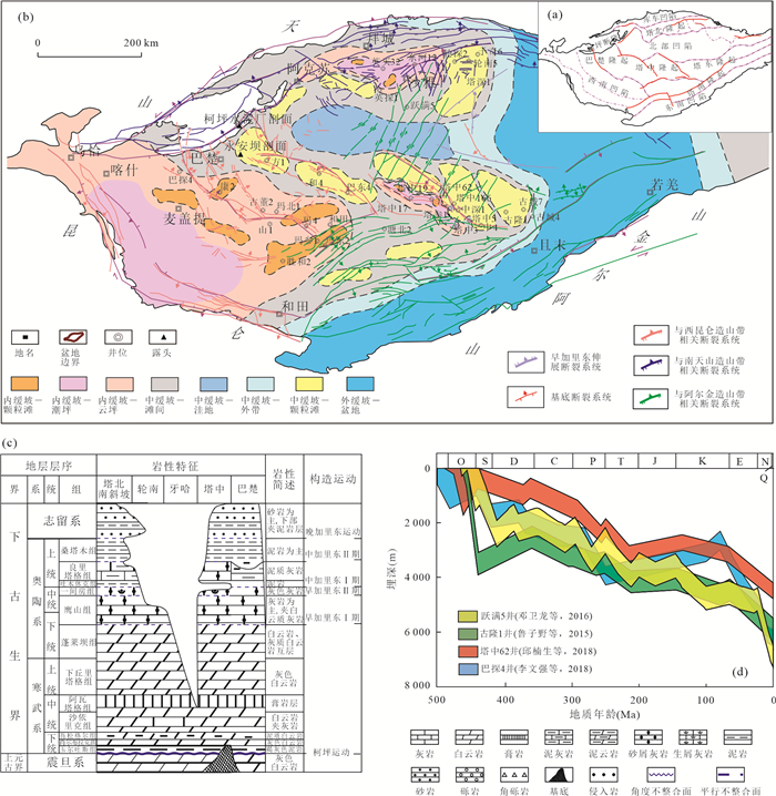


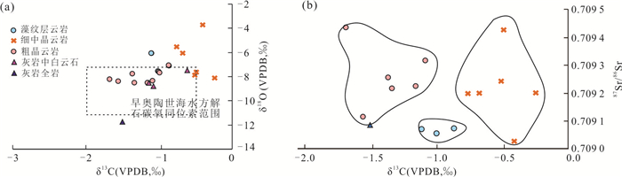

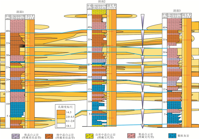


2023, 48(2): 690-704.
doi: 10.3799/dqkx.2022.304
Abstract:
Carbonate rock is the major target horizon for Paleogene oil/gas exploration in the Tazhong area of the Tazhong Low Salient, Well G70 in the north slope of Tazhong obtained high⁃yield industrial gas flow in the test of the fourth member of Yingshan Formation of Lower Ordovician, and the deep layer of Ordovician in the northern slope of Tazhong Low Salient showed broad exploration potential and can be used as the next important replacement domain of carbonate rocks in Tazhong uplift. Searching for high⁃quality reservoirs around oil source fracture is still the first choice for deep ordovician exploration target and target selection, but the distribution of o oil source fracture and distribution of high⁃quality reservoirs need to be further clarified. Based on 3D seismic data of Tazhong, combined with single well logging, well logging and physical properties of oil and gas, we analyzed oil source fracture characteristics, reservoir prediction and property controlling factors. It is found that the East and West ends of Tazhong No 1 fault, the west section of thrust fault in Tazhong No.10 fault belt and the numbered F1⁃F16 of NE strike slip fault have long⁃term effect of transporting oil and gas, which are the main oil source faults of Ordovician oil and gas accumulation in Tazhong Low Salient; In the relatively stable area of paleokarst landform, large⁃area and long⁃term water rock contact is conducive to the development of karst cave reservoirs; The late fault activity not only transformed the reservoir performance, but also enhanced the karstification, in the superposition area of fault and paleokarst landform stability area, it is more conducive to the development of high⁃quality karst cave reservoirs.Based on the above work, a comprehensive evaluation of reservoir formation was carried out based on regional seal distribution, high⁃quality reservoir distribution and fault distribution, and eleven Class Ⅰ favorable areas selected, to direct future exploration.
Carbonate rock is the major target horizon for Paleogene oil/gas exploration in the Tazhong area of the Tazhong Low Salient, Well G70 in the north slope of Tazhong obtained high⁃yield industrial gas flow in the test of the fourth member of Yingshan Formation of Lower Ordovician, and the deep layer of Ordovician in the northern slope of Tazhong Low Salient showed broad exploration potential and can be used as the next important replacement domain of carbonate rocks in Tazhong uplift. Searching for high⁃quality reservoirs around oil source fracture is still the first choice for deep ordovician exploration target and target selection, but the distribution of o oil source fracture and distribution of high⁃quality reservoirs need to be further clarified. Based on 3D seismic data of Tazhong, combined with single well logging, well logging and physical properties of oil and gas, we analyzed oil source fracture characteristics, reservoir prediction and property controlling factors. It is found that the East and West ends of Tazhong No 1 fault, the west section of thrust fault in Tazhong No.10 fault belt and the numbered F1⁃F16 of NE strike slip fault have long⁃term effect of transporting oil and gas, which are the main oil source faults of Ordovician oil and gas accumulation in Tazhong Low Salient; In the relatively stable area of paleokarst landform, large⁃area and long⁃term water rock contact is conducive to the development of karst cave reservoirs; The late fault activity not only transformed the reservoir performance, but also enhanced the karstification, in the superposition area of fault and paleokarst landform stability area, it is more conducive to the development of high⁃quality karst cave reservoirs.Based on the above work, a comprehensive evaluation of reservoir formation was carried out based on regional seal distribution, high⁃quality reservoir distribution and fault distribution, and eleven Class Ⅰ favorable areas selected, to direct future exploration.
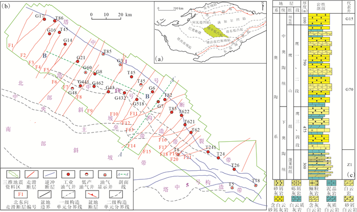

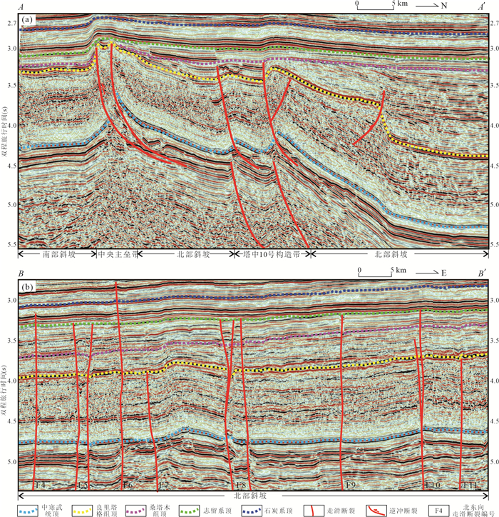


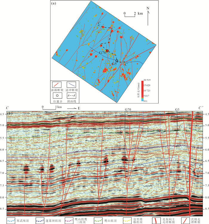
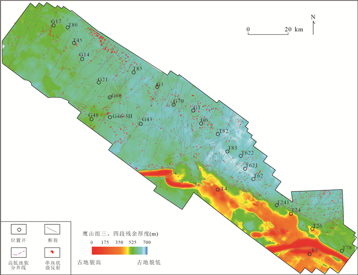


2023, 48(2): 705-718.
doi: 10.3799/dqkx.2022.464
Abstract:
The East Niger basin group belongs to the West African Rift System. Based on seismic, drilling, side wall core, and geochemical analysis data of Donga formation, this paper analyses its depositional system, play and exploration potential. Donga formation is a normal cycle sequence formed in late Cretaceous transgression, and the top is developed with thin carbonate rocks. This sequence is widely developed in the Upper Cretaceous of the East Niger Basin Group, which indicates that seawater flooded these basins during the Late Cretaceous and forms a temporarily unified basin. The transgression event significantly affected the sedimentary system of the Late Cretaceous basin and controlled its petroleum system and hydrocarbon accumulation. The widely deposited mudstone can be a good hydrocarbon source rock and cap rock. There are two plays in Donga formation, upper generation and lower reservoir, supply hydrocarbon laterally, and self⁃generated and self⁃stored. Reservoir is the control factor of Donga formation hydrocarbon accumulation, the moderate buried and near provenance area in the north and southeast margin could develop good reservoir and has good exploration potential.
The East Niger basin group belongs to the West African Rift System. Based on seismic, drilling, side wall core, and geochemical analysis data of Donga formation, this paper analyses its depositional system, play and exploration potential. Donga formation is a normal cycle sequence formed in late Cretaceous transgression, and the top is developed with thin carbonate rocks. This sequence is widely developed in the Upper Cretaceous of the East Niger Basin Group, which indicates that seawater flooded these basins during the Late Cretaceous and forms a temporarily unified basin. The transgression event significantly affected the sedimentary system of the Late Cretaceous basin and controlled its petroleum system and hydrocarbon accumulation. The widely deposited mudstone can be a good hydrocarbon source rock and cap rock. There are two plays in Donga formation, upper generation and lower reservoir, supply hydrocarbon laterally, and self⁃generated and self⁃stored. Reservoir is the control factor of Donga formation hydrocarbon accumulation, the moderate buried and near provenance area in the north and southeast margin could develop good reservoir and has good exploration potential.


2023, 48(2): 719-734.
doi: 10.3799/dqkx.2023.038
Abstract:
Distribution of oil and gas/condensate fields is characterized with the feature of "large hydrocarbon reserves and heavy oil density in deep-water zone, while small hydrocarbon reserves and light oil density in relative shallow water area". Light oil reservoirs (with oil density of 36-58 API°) or gas/condensate reservoirs are located in the proximal shallow water area within the water depth of 1000 m with small hydrocarbon reserves, and oil fields in deep water area with water depth more than 1500 m, are mainly of normal oil (with oil density of 25-32 API°). The distribution of oil and gas fields is constrained by the nature of pre-salt and post-salt source rocks, source rock maturity and salt development. Lacustrine source rocks pre-salt with type Ⅰ organic matter are prone to oil, and of the high or over mature stage in central depression and of the mature stage in eastern deep-water area. Marine source rocks post-salt mainly of type Ⅱ2-Ⅲ kerogen are prone to light oil and gas, with the maturity of late oil window stage in central depression and western are of Santos basin. Studies show that light oils and gas condensate oils of post-salt reservoirs are originated from marine source rocks post salt of high maturity, while oils from deep water and north area of central depression mainly came from pre-salt high quality lacustrine source rocks of medium maturity. Constraining on the characteristic and origin of hydrocarbon of Santos Basin, is helpful to understand the principle of hydrocarbon distribution, generation and accumulation in Santos Basin thoroughly, and it also make significant sense to optimize potential blocks and reduce the risk of investment.
Distribution of oil and gas/condensate fields is characterized with the feature of "large hydrocarbon reserves and heavy oil density in deep-water zone, while small hydrocarbon reserves and light oil density in relative shallow water area". Light oil reservoirs (with oil density of 36-58 API°) or gas/condensate reservoirs are located in the proximal shallow water area within the water depth of 1000 m with small hydrocarbon reserves, and oil fields in deep water area with water depth more than 1500 m, are mainly of normal oil (with oil density of 25-32 API°). The distribution of oil and gas fields is constrained by the nature of pre-salt and post-salt source rocks, source rock maturity and salt development. Lacustrine source rocks pre-salt with type Ⅰ organic matter are prone to oil, and of the high or over mature stage in central depression and of the mature stage in eastern deep-water area. Marine source rocks post-salt mainly of type Ⅱ2-Ⅲ kerogen are prone to light oil and gas, with the maturity of late oil window stage in central depression and western are of Santos basin. Studies show that light oils and gas condensate oils of post-salt reservoirs are originated from marine source rocks post salt of high maturity, while oils from deep water and north area of central depression mainly came from pre-salt high quality lacustrine source rocks of medium maturity. Constraining on the characteristic and origin of hydrocarbon of Santos Basin, is helpful to understand the principle of hydrocarbon distribution, generation and accumulation in Santos Basin thoroughly, and it also make significant sense to optimize potential blocks and reduce the risk of investment.


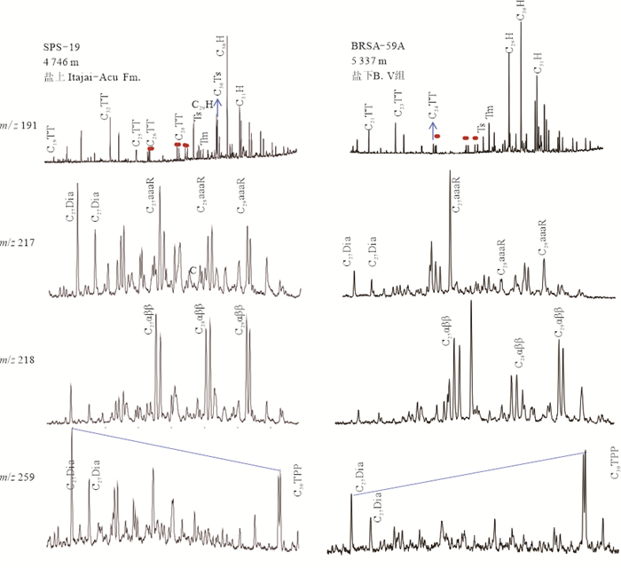


2023, 48(2): 735-748.
doi: 10.3799/dqkx.2022.401
Abstract:
Fault activities play an important role in the formation and evolution of the basin and the petroleum migration and accumulation. Accurately determining the ages and active period of the fault is an indispensable work in the study of basin tectonics and petroleum accumulation, and has always been a difficult work in the geological study. In view of this problem, based on the analysis of the internal structure of the fault zone and previous research results, the commonly used authigenic illite K-Ar/Ar-Ar dating method and quartz ESR dating technology were briefly reviewed in this study. And this paper mainly focuses on discussing the basic principles, experimental methods and typical examples of laser in situ calcite U-Pb dating, quartz fluid inclusions 40Ar/39Ar dating and low-temperature thermochronology technology which applied to the study of fault activity time. The presently existing problems and development trends were analyzed, and the next research direction was pointed out. It is believed that laser in situ calcite U-Pb dating, quartz fluid inclusions 40Ar/39Ar dating and low-temperature thermochronology techniques have important guiding significance for the study of fault activities and petroleum exploration, and will play an important role in the study of basin faults in the future, with broad application prospects.
Fault activities play an important role in the formation and evolution of the basin and the petroleum migration and accumulation. Accurately determining the ages and active period of the fault is an indispensable work in the study of basin tectonics and petroleum accumulation, and has always been a difficult work in the geological study. In view of this problem, based on the analysis of the internal structure of the fault zone and previous research results, the commonly used authigenic illite K-Ar/Ar-Ar dating method and quartz ESR dating technology were briefly reviewed in this study. And this paper mainly focuses on discussing the basic principles, experimental methods and typical examples of laser in situ calcite U-Pb dating, quartz fluid inclusions 40Ar/39Ar dating and low-temperature thermochronology technology which applied to the study of fault activity time. The presently existing problems and development trends were analyzed, and the next research direction was pointed out. It is believed that laser in situ calcite U-Pb dating, quartz fluid inclusions 40Ar/39Ar dating and low-temperature thermochronology techniques have important guiding significance for the study of fault activities and petroleum exploration, and will play an important role in the study of basin faults in the future, with broad application prospects.

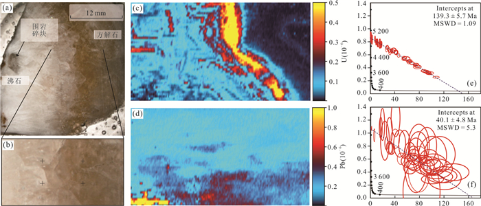
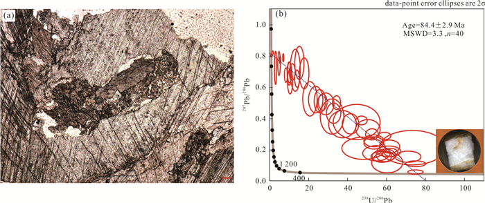
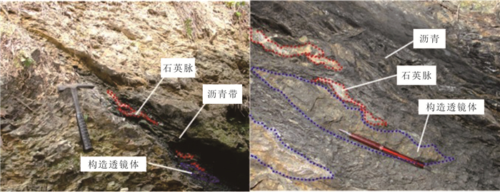


2023, 48(2): 749-763.
doi: 10.3799/dqkx.2022.465
Abstract:
The Hetao Basin has a low degree of exploration and the favorable exploration strata are deeply buried. No breakthroughs have been achieved in more than 40 years. In order to achieve rapid breakthroughs in oil and gas exploration in Hetao Basin, high⁃precision gravity and time⁃frequency electromagnetic exploration have been carried out as a whole. Aiming at the problems that the main hydrocarbon⁃generating areas in the basin are unclear and the structure is difficult to determine, a new technology for deep target gravity anomaly extraction based on loose constrained multi⁃interface inversion based on finite well and seismic data and gravity forward stripping based on basement background density methodis applied.After these work, the geological structure of Linhe depression is re⁃recognized and the distribution of main hydrocarbon generating sags is quickly confirmed. It's pointed out that the Naoxi deep sub⁃sag of Bayannur sag in the north of the depression is the most favorable hydrocarbon generating area. The newly discovered favorable exploration targets for near source oil and gas, such as the central Xinglong faulted horst type buried hill drape structural belt and the nose shaped buried hill drape structural belt on the east wing of Jixi high, which are distributed around the Yellow River fault sub⁃sag and Naoxi deep sub⁃sag have led to targeted, rapid and efficient seismic deployment and drilling. Aiming at the problems of unclear reservoir target and difficult determination of breakthrough well location, time⁃frequency electromagnetic exploration supporting technologies such as target layer targeted acquisition based on well seismic simulation, electric⁃magnetic⁃well⁃seismic joint constrained inversion to improve the resolution of deep exploration and the prediction accuracy of oil and gas reservoirs have been proposed and applied. The resolution of deep exploration and the prediction accuracy of oil and gas reservoirs are improved. Favorable target areas such as well JHZK2, well Jihua 2x and well Linhua 1x are quickly locked. It has played a key leading role in the efficient breakthrough of oil and gas exploration in Hetao Basin and has provided successful examples and technical methods for deep oil and gas exploration in similar complex areas and special basins.
The Hetao Basin has a low degree of exploration and the favorable exploration strata are deeply buried. No breakthroughs have been achieved in more than 40 years. In order to achieve rapid breakthroughs in oil and gas exploration in Hetao Basin, high⁃precision gravity and time⁃frequency electromagnetic exploration have been carried out as a whole. Aiming at the problems that the main hydrocarbon⁃generating areas in the basin are unclear and the structure is difficult to determine, a new technology for deep target gravity anomaly extraction based on loose constrained multi⁃interface inversion based on finite well and seismic data and gravity forward stripping based on basement background density methodis applied.After these work, the geological structure of Linhe depression is re⁃recognized and the distribution of main hydrocarbon generating sags is quickly confirmed. It's pointed out that the Naoxi deep sub⁃sag of Bayannur sag in the north of the depression is the most favorable hydrocarbon generating area. The newly discovered favorable exploration targets for near source oil and gas, such as the central Xinglong faulted horst type buried hill drape structural belt and the nose shaped buried hill drape structural belt on the east wing of Jixi high, which are distributed around the Yellow River fault sub⁃sag and Naoxi deep sub⁃sag have led to targeted, rapid and efficient seismic deployment and drilling. Aiming at the problems of unclear reservoir target and difficult determination of breakthrough well location, time⁃frequency electromagnetic exploration supporting technologies such as target layer targeted acquisition based on well seismic simulation, electric⁃magnetic⁃well⁃seismic joint constrained inversion to improve the resolution of deep exploration and the prediction accuracy of oil and gas reservoirs have been proposed and applied. The resolution of deep exploration and the prediction accuracy of oil and gas reservoirs are improved. Favorable target areas such as well JHZK2, well Jihua 2x and well Linhua 1x are quickly locked. It has played a key leading role in the efficient breakthrough of oil and gas exploration in Hetao Basin and has provided successful examples and technical methods for deep oil and gas exploration in similar complex areas and special basins.


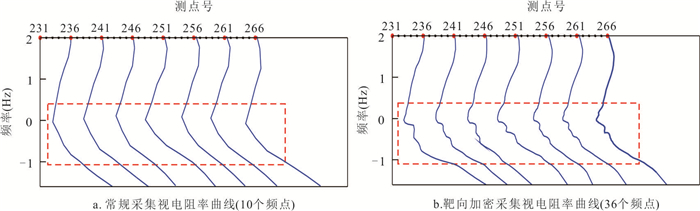

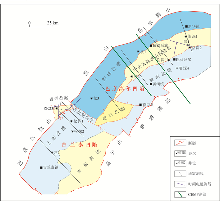


2023, 48(2): 764-775.
doi: 10.3799/dqkx.2022.267
Abstract:
The development mode with dense well pattern in land is not applicable to offshore shallow water delta oilfield, This paper studies the development technology of horizontal wells in offshore shallow water delta oilfield. Based on the sedimentary model of shallow water delta and the principle of seismic sedimentology, the formation conditions, genetic mechanism and distribution characteristics of shallow water delta reservoir in BZ oilfield are put forward. The primary well pattern is deployed and optimized through large⁃scale physical model experiment and reservoir numerical simulation. The development type of shallow water delta reservoir in BZ oilfield is continuous lobed composite sand body formed by lateral migration and superposition of multiple single distributary channels, Three river contact patterns were identified. The primary well pattern of offshore shallow water delta oilfield adopts horizontal well staggered well pattern, and the effect of oil production in the upper part and water injection development in the lower part of the reservoir is the best. The well pattern optimization method under three channel contact patterns is proposed. For the first time, the development mode of horizontal well and single sand body layered system based on single channel in offshore shallow water delta oilfield is proposed, which is applied in BZ oilfield, and the development effect is evaluated as class I.
The development mode with dense well pattern in land is not applicable to offshore shallow water delta oilfield, This paper studies the development technology of horizontal wells in offshore shallow water delta oilfield. Based on the sedimentary model of shallow water delta and the principle of seismic sedimentology, the formation conditions, genetic mechanism and distribution characteristics of shallow water delta reservoir in BZ oilfield are put forward. The primary well pattern is deployed and optimized through large⁃scale physical model experiment and reservoir numerical simulation. The development type of shallow water delta reservoir in BZ oilfield is continuous lobed composite sand body formed by lateral migration and superposition of multiple single distributary channels, Three river contact patterns were identified. The primary well pattern of offshore shallow water delta oilfield adopts horizontal well staggered well pattern, and the effect of oil production in the upper part and water injection development in the lower part of the reservoir is the best. The well pattern optimization method under three channel contact patterns is proposed. For the first time, the development mode of horizontal well and single sand body layered system based on single channel in offshore shallow water delta oilfield is proposed, which is applied in BZ oilfield, and the development effect is evaluated as class I.


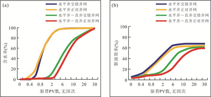
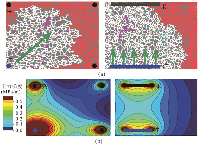


2023, 48(2): 776-792.
doi: 10.3799/dqkx.2022.458
Abstract:
The Paleogene Zhuhai Formation in the deep Wenchang A Sag of the Pearl River Mouth Basin is rich in oil and gas resources, but the distribution of oil and gas reservoirs in different regions is complex, and the study of inclusions, the key evidence of oil and gas accumulation period, is relatively weak. In order to accurately determine the hydrocarbon charging periods of Zhuhai Formation in Wenchang A Sag, the hydrocarbon inclusions and their associated brine inclusions in the sandstone reservoirs of Zhuhai Formation in the study area were taken as the research object. Fluorescence spectroscopy, laser Raman spectroscopy, micro thermometry and other related experiment were used, combined with the analysis of inclusion capture pressure calculation, burial history, paleogeothermal evolution history, and thermal evolution history of hydrocarbon source rocks. The research on hydrocarbon charging stages and their differences in the central depression and the fault zone has been carried out. The results show that there are three kinds of inclusions, including high⁃density single⁃phase oil inclusions, two⁃phase of gas⁃liquid hydrocarbon inclusions and two⁃phase of gas⁃liquid saline inclusions in the sandstonereservoir. The components of hydrocarbon inclusions and the associated brine inclusions are mainly CH4, C2H6, SO2, CO2 and H2O, and the homogenization temperature of brine inclusions distributed mainly from 95 to 180 ℃. Three stages of hydrocarbon filling occurred both in the central depression and the fault zone, but the hydrocarbon filling time is different. The first hydrocarbon charging occurred in the central depression rangesfrom 21.9 to 13.9 Ma, the second oil filling occurred at 12.0 to 8.9 Ma, and the third oil and gas filling occurred at 7.8 to 4.8 Ma. However, in the fault zone, the first oil charging occurred at 21.7 to 10.2 Ma, the second one occurred at 9.1 to 4.9 Ma, and the third oil and gas filling was about 3.9 to 1.5 Ma. The difference of source rock burial depth, multi⁃stage fault activity and their spatio⁃temporal configuration caused by different tectonic subsidence is the main reason for the difference of hydrocarbon generation peak and hydrocarbon accumulation time in the central depression and fault zone. The research results provide a scientific basis forselection and deployment of oil and gas exploration targets in the study area.
The Paleogene Zhuhai Formation in the deep Wenchang A Sag of the Pearl River Mouth Basin is rich in oil and gas resources, but the distribution of oil and gas reservoirs in different regions is complex, and the study of inclusions, the key evidence of oil and gas accumulation period, is relatively weak. In order to accurately determine the hydrocarbon charging periods of Zhuhai Formation in Wenchang A Sag, the hydrocarbon inclusions and their associated brine inclusions in the sandstone reservoirs of Zhuhai Formation in the study area were taken as the research object. Fluorescence spectroscopy, laser Raman spectroscopy, micro thermometry and other related experiment were used, combined with the analysis of inclusion capture pressure calculation, burial history, paleogeothermal evolution history, and thermal evolution history of hydrocarbon source rocks. The research on hydrocarbon charging stages and their differences in the central depression and the fault zone has been carried out. The results show that there are three kinds of inclusions, including high⁃density single⁃phase oil inclusions, two⁃phase of gas⁃liquid hydrocarbon inclusions and two⁃phase of gas⁃liquid saline inclusions in the sandstonereservoir. The components of hydrocarbon inclusions and the associated brine inclusions are mainly CH4, C2H6, SO2, CO2 and H2O, and the homogenization temperature of brine inclusions distributed mainly from 95 to 180 ℃. Three stages of hydrocarbon filling occurred both in the central depression and the fault zone, but the hydrocarbon filling time is different. The first hydrocarbon charging occurred in the central depression rangesfrom 21.9 to 13.9 Ma, the second oil filling occurred at 12.0 to 8.9 Ma, and the third oil and gas filling occurred at 7.8 to 4.8 Ma. However, in the fault zone, the first oil charging occurred at 21.7 to 10.2 Ma, the second one occurred at 9.1 to 4.9 Ma, and the third oil and gas filling was about 3.9 to 1.5 Ma. The difference of source rock burial depth, multi⁃stage fault activity and their spatio⁃temporal configuration caused by different tectonic subsidence is the main reason for the difference of hydrocarbon generation peak and hydrocarbon accumulation time in the central depression and fault zone. The research results provide a scientific basis forselection and deployment of oil and gas exploration targets in the study area.


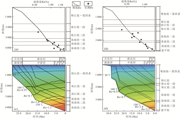


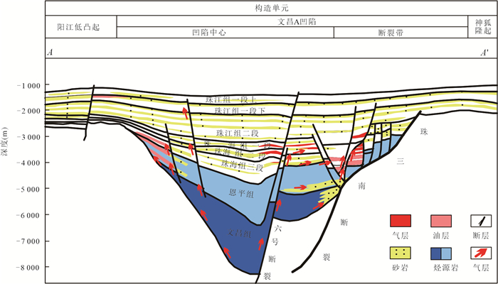
2023, 48(2): 793-813.
doi: 10.3799/dqkx.2022.443
Abstract:
Shale oil plays a significant role in petroleum exploration and development with its huge reserves, concentrated distribution, and broad prospects. Combining the achievements of global shale oil exploration and development, two bibliometric software CiteSpace and VOSviewer were used to visualize the scientific knowledge about the last ten years. The theme evolution, hotspots and frontiers were systematically sort out. Furthermore, the challenges and effective techniques of shale oil research are summarized. The results show that the research hotspots of shale oil focus on four aspects: formation conditions, reservoir property, mobility, and fracturing. The sedimentary tectonic setting is stable and the production technologies are continuously updated in North America. However, the sedimentary phase change of shale oil is rapid in China, and the pore types are greatly affected by diagenesis. In addition, there is no systematic method to evaluate the mobility of shale oil. Hydraulic fracturing sometimes induces earthquakes and causes environmental pollution. To accurately predict the "geological-engineering" sweet spot of shale oil and promote the rapid transformation of energy structure, the following research should be strengthened including the lithofacies of fine-grained sediment, the quantitative characterization of reservoir space, occurrence state of shale oil, the systematic evaluation method of movability, and the advanced green fracturing technology.
Shale oil plays a significant role in petroleum exploration and development with its huge reserves, concentrated distribution, and broad prospects. Combining the achievements of global shale oil exploration and development, two bibliometric software CiteSpace and VOSviewer were used to visualize the scientific knowledge about the last ten years. The theme evolution, hotspots and frontiers were systematically sort out. Furthermore, the challenges and effective techniques of shale oil research are summarized. The results show that the research hotspots of shale oil focus on four aspects: formation conditions, reservoir property, mobility, and fracturing. The sedimentary tectonic setting is stable and the production technologies are continuously updated in North America. However, the sedimentary phase change of shale oil is rapid in China, and the pore types are greatly affected by diagenesis. In addition, there is no systematic method to evaluate the mobility of shale oil. Hydraulic fracturing sometimes induces earthquakes and causes environmental pollution. To accurately predict the "geological-engineering" sweet spot of shale oil and promote the rapid transformation of energy structure, the following research should be strengthened including the lithofacies of fine-grained sediment, the quantitative characterization of reservoir space, occurrence state of shale oil, the systematic evaluation method of movability, and the advanced green fracturing technology.

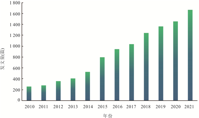


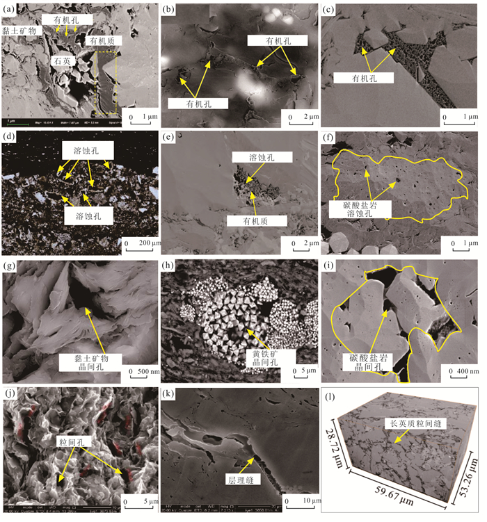

2023, 48(2): 814-834.
doi: 10.3799/dqkx.2023.031
Abstract:
Deep to ultra⁃deep carbonate reservoirs have always been the focus of global oil and gas exploration at present, which are also the future fields of commercial hydrocarbon discovery in China. The importance of early epigenetic dissolution and/or late burial dissolution modification has been generally emphasized for the formation of high⁃quality carbonate reservoirs in deep burial environments. As an effective way to characterize the mechanism of reservoir dissolution, the fluid⁃rock dissolution simulation experiment can reproduce the interaction process between carbonate rocks and diagenetic fluids under actual geological conditions, thus providing a new perspective for determining the dissolution and modification of carbonate reservoirs. In this paper, the research progress of carbonate dissolution simulation experiments in recent years is systematically reviewed. In addition, the controlling factors of dissolution on the formation of deep to ultra⁃deep carbonate rocks are discussed from the perspective of experimental simulation. Firstly, the dissolution and modification of carbonate reservoirs are reviewed, and the techniques and methods of carbonate fluid⁃rock dissolution simulation experiments are summarized. Secondly, the law and understanding of carbonate reservoir dissolution and modification based on simulation experiments are sorted out. Finally, the application prospect of current research on deep to ultra⁃deep hydrocarbon exploration and carbon sequestration and recycling is prospected. Generally, the simulation experiment of carbonate dissolution is expected to provide a basis for discovering the secondary pore development zones during burial diagenesis and clarifying the favorable conditions for the occurrence of large⁃scale dissolution. Furthermore, this work can provide certain reference significance for future research on the formation mechanism and experimental simulation of carbonate reservoirs.
Deep to ultra⁃deep carbonate reservoirs have always been the focus of global oil and gas exploration at present, which are also the future fields of commercial hydrocarbon discovery in China. The importance of early epigenetic dissolution and/or late burial dissolution modification has been generally emphasized for the formation of high⁃quality carbonate reservoirs in deep burial environments. As an effective way to characterize the mechanism of reservoir dissolution, the fluid⁃rock dissolution simulation experiment can reproduce the interaction process between carbonate rocks and diagenetic fluids under actual geological conditions, thus providing a new perspective for determining the dissolution and modification of carbonate reservoirs. In this paper, the research progress of carbonate dissolution simulation experiments in recent years is systematically reviewed. In addition, the controlling factors of dissolution on the formation of deep to ultra⁃deep carbonate rocks are discussed from the perspective of experimental simulation. Firstly, the dissolution and modification of carbonate reservoirs are reviewed, and the techniques and methods of carbonate fluid⁃rock dissolution simulation experiments are summarized. Secondly, the law and understanding of carbonate reservoir dissolution and modification based on simulation experiments are sorted out. Finally, the application prospect of current research on deep to ultra⁃deep hydrocarbon exploration and carbon sequestration and recycling is prospected. Generally, the simulation experiment of carbonate dissolution is expected to provide a basis for discovering the secondary pore development zones during burial diagenesis and clarifying the favorable conditions for the occurrence of large⁃scale dissolution. Furthermore, this work can provide certain reference significance for future research on the formation mechanism and experimental simulation of carbonate reservoirs.